Embed Size (px)
Citation preview
Mobile Applications and Services FALL 2013
Location-based Service and
Geosocial Services
Navid Nikaein
Mobile Communication Department
This work is licensed under a CC attribution Share-Alike 3.0 Unported license.

Content
Basic concept
(Geo-)Location-based services and architecture
Location-based Service Ecosystem
Geo-social service
New trends
©Navid Nikaein 2013 - p 2
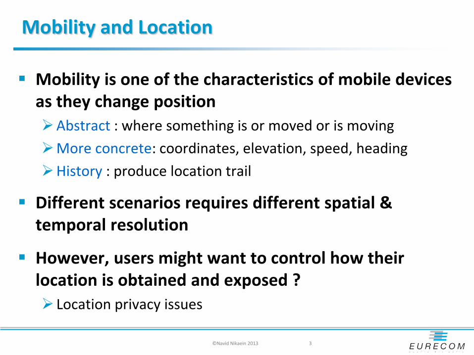
Mobility and Location
Mobility is one of the characteristics of mobile devices as they change position Abstract : where something is or moved or is moving More concrete: coordinates, elevation, speed, heading History : produce location trail
Different scenarios requires different spatial & temporal resolution
However, users might want to control how their location is obtained and exposed ? Location privacy issues
©Navid Nikaein 2013 3

Basic Concept
Position : association of a single point with spatial coordinates Commonly used coordinate system is the latitude-longitude-altitude system Another example is the Universal Transverse Mercator (UTM)
Location : association of an object with a place in the real world, a descriptive position (Locality, Postal or ZIP codes, etc…)
Geolocation : identification of the real-world geographic location of an object establish a location information useful for recommendations, advertising,
marketing, tagging, targeting and etc.
Location Service : Self localization Example: Where am I ?
(Geo-)Location-based service (LBS): Value-added service Report your location to other users Associate/bind real-world locations (cinema) to your location Example: How can I get to a certain place ?
©Navid Nikaein 2013 - p 4

Buzzword of the year 2010
(Geo-)location-based service was the technical buzzword of 2010 Change the way we socialize and discover new places
The next wave of is about value-added services mainly in social networking and professional usage Facebook, Twitter , and Google+ now wants to know
“where are you?”
©Navid Nikaein 2013 5
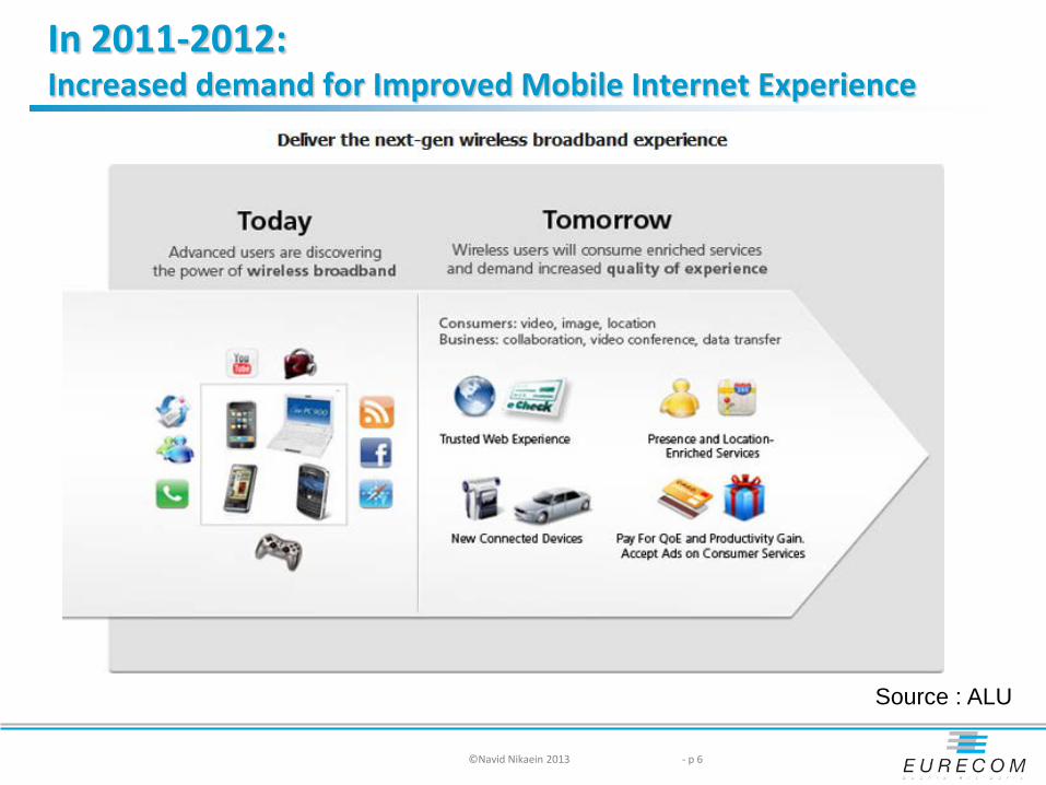
In 2011-2012: Increased demand for Improved Mobile Internet Experience
©Navid Nikaein 2013 - p 6
Source : ALU
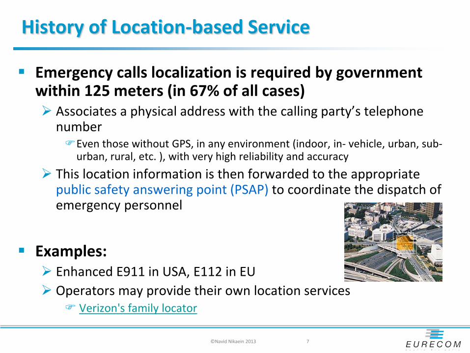
History of Location-based Service
Emergency calls localization is required by government within 125 meters (in 67% of all cases) Associates a physical address with the calling party’s telephone
number Even those without GPS, in any environment (indoor, in- vehicle, urban, sub-
urban, rural, etc. ), with very high reliability and accuracy This location information is then forwarded to the appropriate
public safety answering point (PSAP) to coordinate the dispatch of emergency personnel
Examples: Enhanced E911 in USA, E112 in EU Operators may provide their own location services
Verizon's family locator
7 ©Navid Nikaein 2013

LBS type
Pull Sends a request for local weather forecast by SMS to the
service number 1234.
Push Service provider send information to customer
Operators give the position of the customer to the service providers based on customer permission
Track Get the location of a terminal (person, vehicle, fleet) Permissions is given to the operators to a third party or
service to track the terminal Could provide location profile/history
©Navid Nikaein 2013 - p 8
Location Information Provisioning
Location-Based Services consists of the following 5 steps 1. position determination 2. location pre-processing 3. service operation 4. result pre-processing 5. final result presentation
Which induces four main flaws The location description is specific to the service The location is restricted to the geographic position interpretation It is dependant on the positioning mechanism Only point-based positioning is supported
9 ©Navid Nikaein 2013
Position Acquisition Methods
Trilateration estimates the distance from two or more known time-synchronized
reference points (i.e. BS) received signal strength derived from time-of-arrival (TOA) of received signal
Triangulation Estimate the angle of arrival between the mobile terminal and
three reference points Also known as direction of arrival (DOA) or Angle of Arrival (AOA)
Multilateration or hyperbolic positioning Estimate the time difference of arrival (TDOA) from the mobile
terminal to three reference points without the need for time synchronization
©Navid Nikaein 2013 - p 10
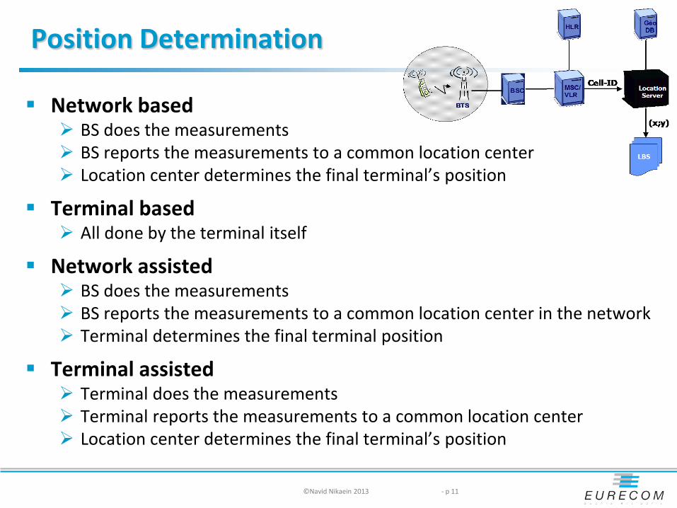
Position Determination
Network based BS does the measurements BS reports the measurements to a common location center Location center determines the final terminal’s position
Terminal based All done by the terminal itself
Network assisted BS does the measurements BS reports the measurements to a common location center in the network Terminal determines the final terminal position
Terminal assisted Terminal does the measurements Terminal reports the measurements to a common location center Location center determines the final terminal’s position
©Navid Nikaein 2013 - p 11

Classification
©Navid Nikaein 2013 - p 12
OTDOA
GPSNon GPS
Proximity TriangulationMultilateration Trilateration
GSM Fingerprinting database
IP/MAC/RFID/UUID/WiFi Fingerprinting database AOA TOA
U-TDOA
E-OTD
AFLT (CDMA)
A-GPS
Cell ID

IP Positioning: Address Problems
Identifying an IP address block's owner can be done through public registries, and used for host or network interface identification Location addressing
Modern network technologies made IP addresses less reliable Network Address Translation (NAT) hides device IP addresses to the outside
world Dynamic Host Configuration Protocol (DHCP) makes IP addresses less static Virtual Private Network (VPN) technology assigns internal addresses for
external devices
IP addresses are still useful as a fallback and for stationary devices big organizations often have a well-defined location and IP addresses for location on the regional level this often is good enough
IP addresses are almost useless for phone-based connectivity expect on the nation-level
14 ©Navid Nikaein 2013

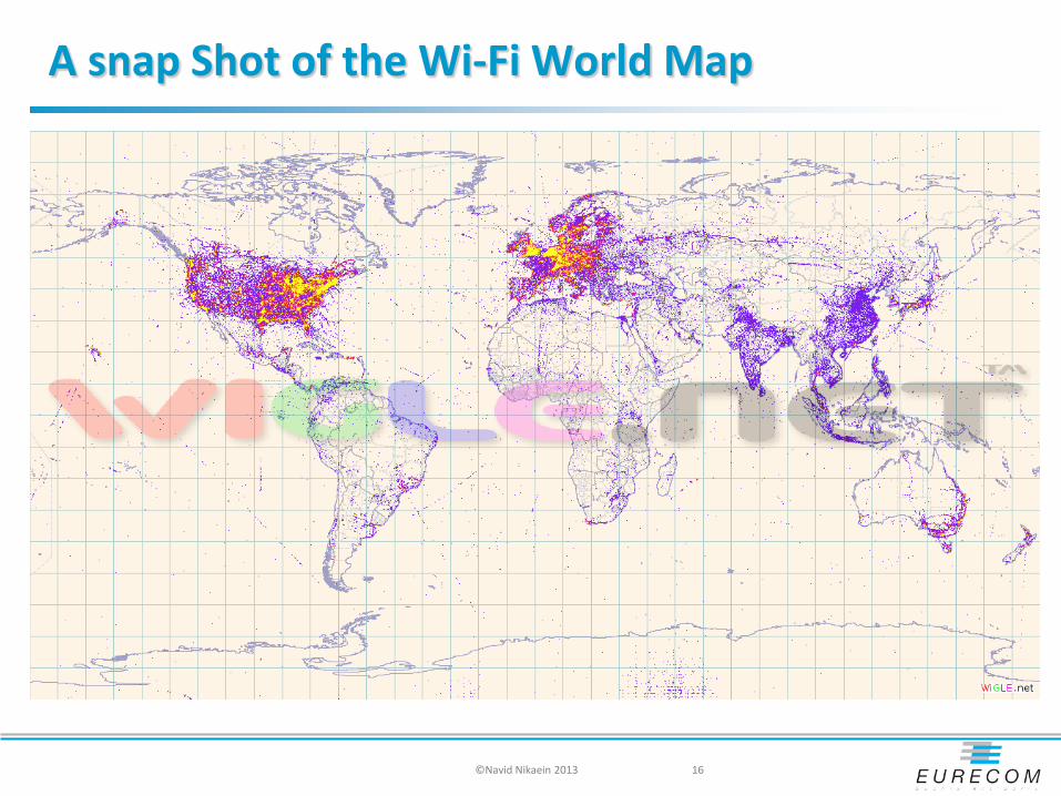
Wi-Fi Positioning
Wi-Fi networks have unique identifiers Media Access Control (MAC) which uniquely identifies each manufactured
device Service Set Identifier (SSID) which is not unique but publicly visible and
reasonably good
Wi-Fi networks have short range and thus provide good localization maximum indoor range of 802.11n is 70m maximum outdoor range of 802.11n is 250m
Wi-Fi networks are widely deployed and identified Wardriving : trend of collecting Wi-Fi information big databases: contain tens of millions of WiFi networks
Links to Geolocation database: http://geomena.org/ http://www.skyhookwireless.com/ http://www.wigle.net/
©Navid Nikaein 2013 15
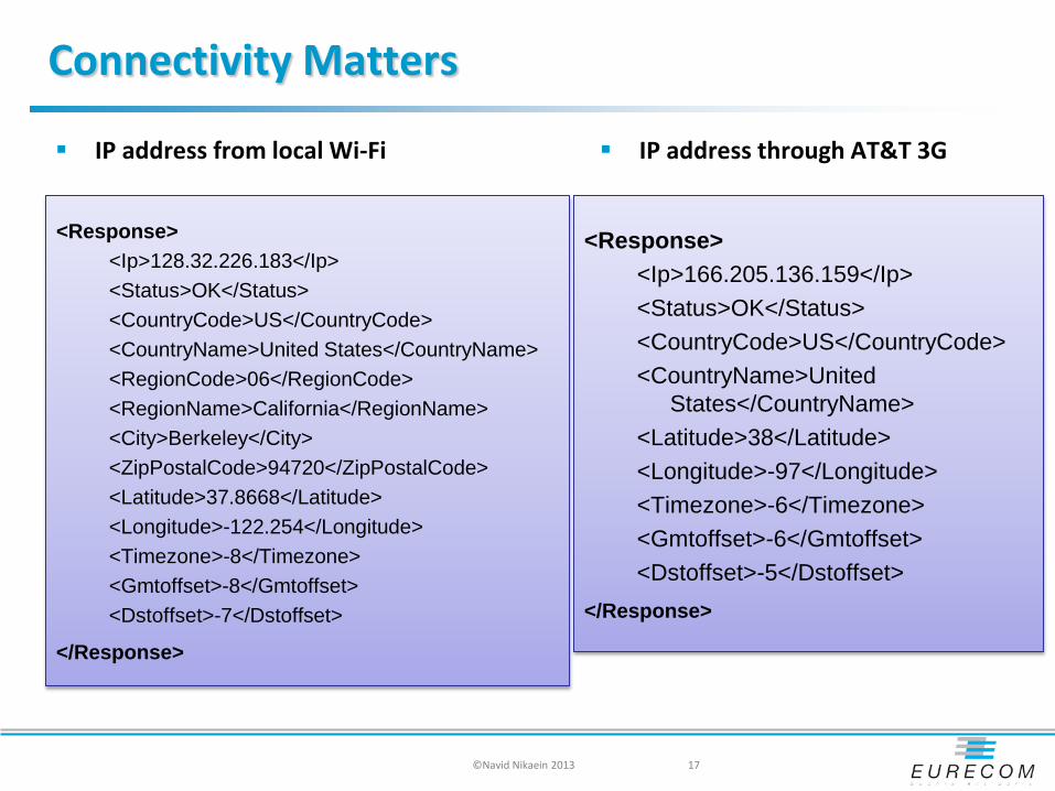
Connectivity Matters
<Response> <Ip>128.32.226.183</Ip> <Status>OK</Status> <CountryCode>US</CountryCode> <CountryName>United States</CountryName> <RegionCode>06</RegionCode> <RegionName>California</RegionName> <City>Berkeley</City> <ZipPostalCode>94720</ZipPostalCode> <Latitude>37.8668</Latitude> <Longitude>-122.254</Longitude> <Timezone>-8</Timezone> <Gmtoffset>-8</Gmtoffset> <Dstoffset>-7</Dstoffset>
</Response>
17
IP address from local Wi-Fi IP address through AT&T 3G
<Response> <Ip>166.205.136.159</Ip> <Status>OK</Status> <CountryCode>US</CountryCode> <CountryName>United
States</CountryName> <Latitude>38</Latitude> <Longitude>-97</Longitude> <Timezone>-6</Timezone> <Gmtoffset>-6</Gmtoffset> <Dstoffset>-5</Dstoffset>
</Response>
©Navid Nikaein 2013

GPS Positioning
Obtain coordination (x,y,z): Latitude, Longitude, Altitude GPS was conceived in the mid-1970's by US’s DoD for people and objects positioning (e.g. Long-range
ballistic missiles need global navigation) first experimental satellite launched in 1978 initial operational capability was achieved in December 1993 Selective Availability (SA) was switched off in 2000 globally available (signal strength is low and receivers requires LoS)
In 2002, the European Union decided to build a GPS-like system called Galileo which is scheduled to start operations in 2014 Same (military) frequency is used for GPS and Galileo
Beidou navigation system in China is now online for region service, and will provide world-wide service by 2020 北斗导航系统
GLONASS Globalnaya Navigatsionnaya Sputnikovaya Sistema or Global Navigation Satellite System Augmented service
WAAS/EGNOS/MSAS, Differential GPS (DGPS), Nationwide Differential GPS (NDGPS), Real-Time Kinematic (RTK)
©Navid Nikaein 2013 18
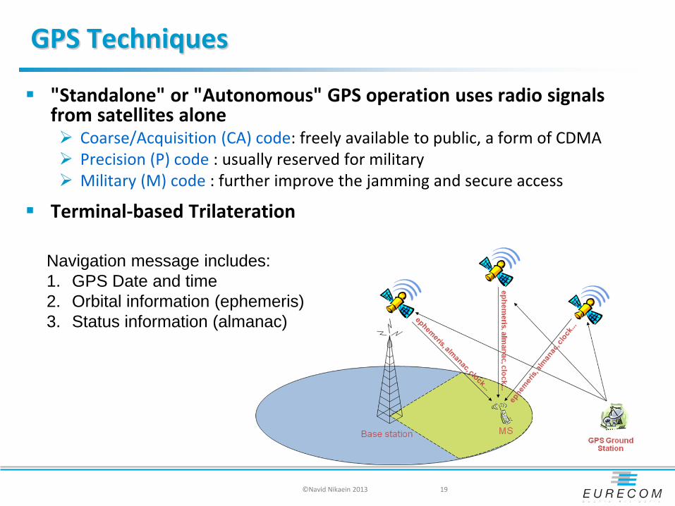
GPS Techniques
"Standalone" or "Autonomous" GPS operation uses radio signals from satellites alone Coarse/Acquisition (CA) code: freely available to public, a form of CDMA Precision (P) code : usually reserved for military Military (M) code : further improve the jamming and secure access
Terminal-based Trilateration
19
Navigation message includes: 1. GPS Date and time 2. Orbital information (ephemeris) 3. Status information (almanac)
©Navid Nikaein 2013

A-GPS : Assisted GPS
A-GPS additionally uses network resources to locate and utilize the satellites in poor signal conditions Improve the initial position acquisition performance (delay, precision) Useful in poor signal conditions, e.g. a city, indoor environment
Supply ephemeris and almanac data to the terminal for faster lock on CA code Network-based /handset-assisted trilateration
20 ©Navid Nikaein 2013

A-GPS : Assisted GPS
The assistance server locate the phone roughly by the cell it is connected to on the cellular
network. has a good satellite signal, and lots of computation power, so it can
compare fragmentary signals relayed to it by cell phones with the satellite signal it receives directly, and then inform the cell phone or emergency services of the cell phone’s position
supply ephemeris and/or almanac data for the GPS satellites to the cell phone, enabling the cell phone to lock on to the satellites faster in some cases
The BS captures a brief snapshot of the GPS signal, with approximate time, for the server to later process into a position By having accurate, surveyed coordinates for the cell site towers, it has
better knowledge of ionospheres' conditions and other errors affecting the GPS signal than the cell phone alone, enabling more precise calculation of position.
21 ©Navid Nikaein 2013

Geolocation API
W3C provides efforts to standardize an interface to retrieve the geographical location information for a client side device
GPS-based coordinates have become the norm globally usable and readily available from GPS receivers printed maps start supporting WGS84 coordinates as well
http://dev.w3.org/geo/api/spec-source.html http://en.wikipedia.org/wiki/W3C_Geolocation_API
22
interface Position { readonly attribute Coordinate coords; readonly attribute DOMTimeStamp timestamp; };
interface Coordinates { readonly attribute double latitude; readonly attribute double longitude; readonly attribute double altitude; readonly attribute double accuracy; readonly attribute double altitudeAccuracy; readonly attribute double heading; readonly attribute double speed;
};
©Navid Nikaein 2013
Geocoding and Reverse Geocoding
The current API only supports coordinates civic locations will be supported in the next version
Geocoding turns locations into coordinates Eurecom, Sophia → (43.623731,7.041106)
Reverse Geocoding turns coordinates into locations (43.623731,7.041106) → Eurecom, Sophia
Geocoding is not a simple 1:1 mapping operation most locations are not points; they are areas most points can be associated with more than one location
Geonames.org provides data and Web services for (reverse) geocoding findNearBy(43.623731,7.041106) extendedfindNearby(43.623731,7.041106) findNearbyPostalCodes(43.623731,7.041106)
23 ©Navid Nikaein 2013
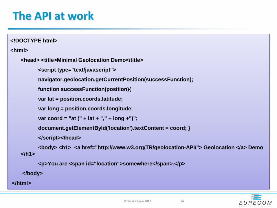
The API at work
<!DOCTYPE html>
<html>
<head> <title>Minimal Geolocation Demo</title>
<script type="text/javascript">
navigator.geolocation.getCurrentPosition(successFunction);
function successFunction(position){
var lat = position.coords.latitude;
var long = position.coords.longitude;
var coord = "at (" + lat + "," + long +")";
document.getElementById('location').textContent = coord; }
</script></head>
<body> <h1> <a href="http://www.w3.org/TR/geolocation-API/"> Geolocation </a> Demo </h1>
<p>You are <span id="location">somewhere</span>.</p>
</body>
</html>
24 ©Navid Nikaein 2013

Applications Requirements
26
Cell ID +TAE CGITDOA CellIDGPSA-GPS
Rural
Sub-Urban
Urban
CityIndoor
10 100 1000 10000 m
Emergency
Navigation
Tracking
Traffic Info
Weather Forcast
Yellow PagesHigh AccuracyServices
Low AccuracyServices
©Navid Nikaein 2013
A-GPS
GPS

Location-based Service Architecture
Control plane a standard-based implementation in which the positioning
messages are transported over the control signaling channels of the mobile network User traffic (voice or data) can be transported in parallel with
positioning data
Data plane Based on IP transmission of positioning messages
All the positioning messaging appears as user traffic to the mobile network.
U-Plane can be used either as an alternative or as a complementary to the C-Plane approaches
©Navid Nikaein 2013 - p 27
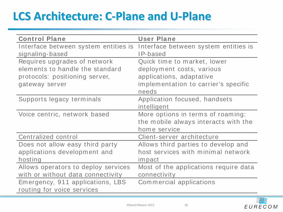
LCS Architecture: C-Plane and U-Plane
28
Control Plane User Plane Interface between system entities is signaling-based
Interface between system entities is IP-based
Requires upgrades of network elements to handle the standard protocols: positioning server, gateway server
Quick time to market, lower deployment costs, various applications, adaptative implementation to carrier’s specific needs
Supports legacy terminals Application focused, handsets intelligent
Voice centric, network based More options in terms of roaming: the mobile always interacts with the home service
Centralized control Client-server architecture Does not allow easy third party applications development and hosting
Allows third parties to develop and host services with minimal network impact
Allows operators to deploy services with or without data connectivity
Most of the applications require data connectivity
Emergency, 911 applications, LBS routing for voice services
Commercial applications
©Navid Nikaein 2013

Geolocation
Location has always been important and is not just a new trends in smartphone Where can I find something to eat? Where is the post office ?
But in 21 century, people are mobile around the globe Physical position/location becomes more important than ever
Geolocation is an association of an object with a geographical position/coordinate
©Navid Nikaein 2013 - p 34

Difference between Geolocation and Places?
Geolocation 43.626854,7.047082
Place Research institute My graduate school Eurecom
Only places have a social meaning
Social Networking + Places = GeoSocial Network
©Navid Nikaein 2013 - p 35
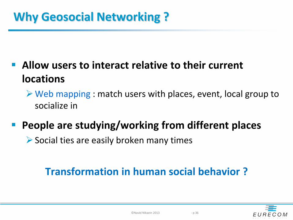
Why Geosocial Networking ?
Allow users to interact relative to their current locations Web mapping : match users with places, event, local group to
socialize in
People are studying/working from different places Social ties are easily broken many times
Transformation in human social behavior ?
©Navid Nikaein 2013 - p 36

Why Geosocial Networking ?
Collaborate and help when something happens Disaster: natural catastrophe, epidemic , terrorist attach Event : protect, manifestation, news Shopping: exchange/barter, buy/sell, ads
Usage Collaborative map : develop a collective situational awareness
through an assembly of individual perspective around collaboratively filtered geotag information
Collaborative event: organize, track, and communicate events Social shopping : collect information on different items as you
pass by ThisNext, Shopkick, and Do Together
©Navid Nikaein 2013 - p 37

Why second life did not succeed
Locations are virtual
People were anonymous difficult to find friends difficult to create presence
Tele-transporting and flying as a way to navigate and search
Not easy to pop/push an information
3D experience not matured Difficult to convey the information
©Navid Nikaein 2013 - p 38

Until now, but
Being online remains virtual the missing piece is the physical link between person and
society
Identification service Mapping a person’s online identity to their real life identify
©Navid Nikaein 2013 - p 39

©Navid Nikaein 2013 - p 40
Geosocial Networking
Type of social networking in which geolocation/location-based services and capabilities such as geocodeing and geotagging are used to generate additional social dynamics [wikipedia] Where are your friends right now ? What did your friends do this WE? Who were your friends hanging out with? What is this place? What is the hot spot around me right now ?
Geosocial Networking Trends: Support for other social networks Native and web based application Gaming aspects Augmented reality Man-machine social networking

Why Facebook is successful
Mapping to people’s reallife Originate from the real world People are real with the real name and photo
Community medium Value increases with every new member
Feedback system Action and response
Cheap and easy to maintain your social network Self communication and promotion
Let friends sort the information
Re-establish the broken social ties
Personal identify Associations (movie, music, fashion, etc. ) Share stuff and exchange information
©Navid Nikaein 2013 - p 41
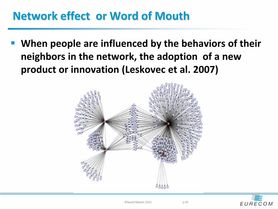
Network effect or Word of Mouth
When people are influenced by the behaviors of their neighbors in the network, the adoption of a new product or innovation (Leskovec et al. 2007)
©Navid Nikaein 2013 - p 42

Why Geosocial ?
Growth of Geosocial network Samrtphones increase usage New emerging device like iPad and Galaxy Tab Gaming and augmented reality aspect Functional application
Waze: realtime live map and traffic information based on wisdom of the crowd
Observation: Fast growing but fragmented market Increasing number of users Emerging opportunities yet small market
©Navid Nikaein 2013 - p 43

What Can You Do With Geosocial Services?
Check ins
• Friend finder • Leave extra
information
Earn points and unlock rewards
• Owner of Places • Get real or
imaginary discounts
Discover the world around you
• See the nearby places and business
• Get direction and contact info
• Connect to friends
• Location alert
Create challenge
• Add your own trips/ places / business
• Add tips about your visits
• Add story
Analyze and manage locations
• Privacy • Monitor your
establishment
©Navid Nikaein 2013 - p 44

Main Geosocial platforms
Basic Platforms Foursquare Gowalla Facebook Places Google latitude Loopt / Loopt Star
Gaming Platform SCVNGR Whrrl
Augmented Reality Yelp Layar
©Navid Nikaein 2013 - p 45

Foursquare
©Navid Nikaein 2013 - p 46
Location-based service for social networking : move – check-in – tell friends Friend finder and social city guide Gaming aspect
Become mayor, get badges and special offers Badges are little rewards you earn for doing or checking-into interesting places
Earn points Track the history Create private/public to do list and tips for a venue
Other features Biggest Geosocial community : 4 million users Developers API Establishment may reward their customers Support for Facebook, Twiter and gmail contact Support for iPhone, Android, webOS, WP7, BB Three level of super users status with varying levels of control to edit locations Partners NY times Web and mobile application
Maybe bought by Yahoo
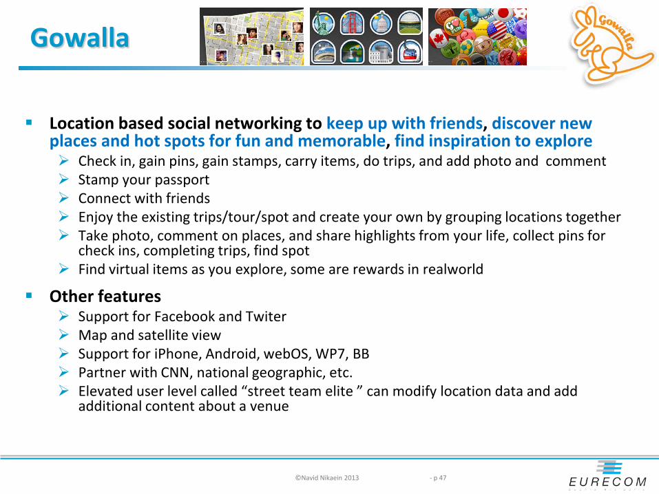
Gowalla
Location based social networking to keep up with friends, discover new places and hot spots for fun and memorable, find inspiration to explore Check in, gain pins, gain stamps, carry items, do trips, and add photo and comment Stamp your passport Connect with friends Enjoy the existing trips/tour/spot and create your own by grouping locations together Take photo, comment on places, and share highlights from your life, collect pins for
check ins, completing trips, find spot Find virtual items as you explore, some are rewards in realworld
Other features Support for Facebook and Twiter Map and satellite view Support for iPhone, Android, webOS, WP7, BB Partner with CNN, national geographic, etc. Elevated user level called “street team elite ” can modify location data and add
additional content about a venue
©Navid Nikaein 2013 - p 47

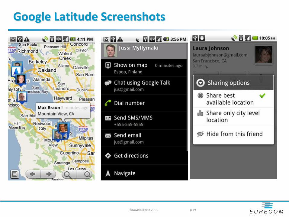
Google Latitude
Location-aware mobile app mapped to google map Find your friends on a map and see nearby friends and meet up Share where you are with the friends you choose Control your location and privacy settings Other services
Location history: manage and analyze user locations with google map( e.g. view trips). Not shared.
Location alert: notification when you are near your friends, or doing something different than routines
Location badge: publish your location or city spots on your blog/website Google talk status : share information with all of your google contacts
Standalone and web app support for iPhone Feature of google maps for android, blackberry, symbian, WP
Google Places (business oriented) Add google tags to be found on google search and maps
©Navid Nikaein 2013 - p 48

Facebook Places
Before just who, what, when, and now includes where Share where you are
Check in and your page “Place/Wall/News Feed” will be updated automatically
Tag the friends to activate group update Appear in “Here Now” to nearby friends
Connect with friends nearby Check out “Here Now” of nearby friends and get in touch with them
Find local deals Get special offers through “deal” logo Check in and get discounts Check out good deals and let friends know about it
©Navid Nikaein 2013 - p 50

Other platforms : game
SCVNGR: a game about doing challenges at places Go places Create challenges Do Challenges through check in Earn points and unlock awards Integration with facebook and twitter Consumer and enterprise components
WHRRL : a game to unlock societies and leave your footstream Check in Create societies based on users’ real world passions Create recommendation Earn points and rewards Create story with posting photos and notes
©Navid Nikaein 2013 - p 51

Other platforms : Augmented Reality
Layar: retrieve data based on your geolocation, and overlay real time digital information on top of the real world as seen through the camera of your mobile phone
©Navid Nikaein 2013 - p 52

Google +
Company 4th attempt for social networking platform Google profiles, buzz, friend connect, orkut
Refresh the visual design across Google products to achieve a consistent experience across the Google spectrum
Features Circles : organize contacts into groups for sharing Hangout: group video, instant webcast, share docs Sparks: front-end for google search for identifying topics messenger: instant messaging with sms support Ripple: rehashing activities happens in a public post Creative kit: online photo editor Games, Instant upload, Messenger, +1, search, pages, badge,
mobile
©Navid Nikaein 2013 - p 53

Privacy Issues
Opt. in vs. opt. out user should join or sign up to network, and then the host is
given permission to access the user's information and to contact him or her
network is defaulted to have the user included in a group, and users must remove themselves from the network if they wish to not be included
©Navid Nikaein 2013 - p 55
Geosocial Business leverage
Discounts for check ins / Mayor-ships
Custom icons for branding
search, follow and track the customers
Promotional campaigns for product launches
Custom event stamps for special events
Loyalty /reward campaigns
Example: Starbucks coffee : as a mayor of the store, get $1 off
©Navid Nikaein 2013 - p 56

Geosocial Networking & Journalism
Finding target contacts
Breaking news
Source information from tips/comments
Learn about people around and their behavior
Discover and monitor trends
Publish and distribute contents
Crowd sourcing news and rewarding readers with badges
©Navid Nikaein 2013 - p 57

Quick Response (QR) Code
2 dimensional barcode readable by QR scanner allowing fast readability and large storage capacity (ISO standard, free of license) Legacy data: numeric, alphanumeric, bytes/binary, kanji Any other type of data through extensions
Created by Toyota in 1994 for tracking parts in vehicle manufacturing Also readable by smartphones through camera
Realtime analytical Social networking Live content to be received instantly Run javascript Invoke application on your phone
Risks malicious website enabling the microphone/camera/GPS and streaming those feeds to a remote server
Example: Qrpedia, SPARQ Code
©Navid Nikaein 2013 - p 59
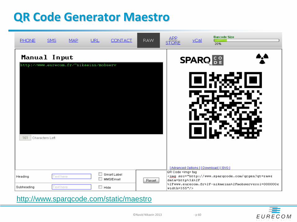
QR Code Generator Maestro
©Navid Nikaein 2013 - p 60
http://www.sparqcode.com/static/maestro
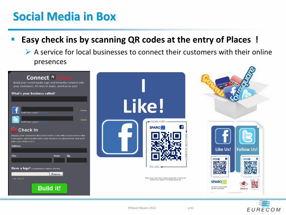
Social Media in Box
Easy check ins by scanning QR codes at the entry of Places ! A service for local businesses to connect their customers with their online
presences
©Navid Nikaein 2013 - p 61

Near Field Communication
NFC is a contact-less short range (max 10cm) wireless connectivity technology standard Based on RFID technology at 13.56 MHz support both : Initiator /target and active/passive 3 modes
Card emulation, Reader/writer, Peer to peer
Gradually turning to the social side Support for google+ already provided
Check out a place and share it with Circles, and perhaps even add us into somebody's Circle or Hangout
When paying through google wallet ? Google, Apple, Paypal changing the game on how payment is done,
banks are just following !
©Navid Nikaein 2013 - p 62