Embed Size (px)
DESCRIPTION
Fort Collins created MMLOS standards for its streets in the late 1990s and has continued to refine them. Fort Collins standards consider both route characteristics and land use characteristics; high-priority land uses, such as public schools, require higher LOS for pedestrian and bicycle modes.
Citation preview
How to measure
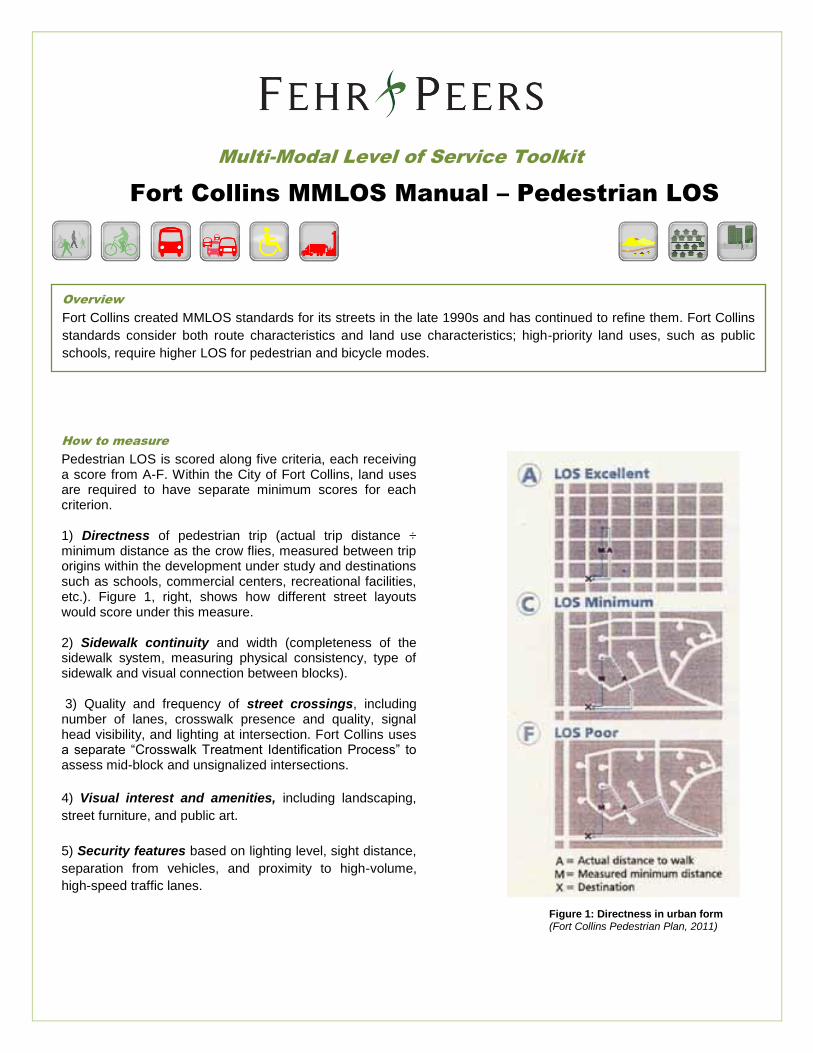
Pedestrian LOS is scored along five criteria, each receiving a score from A-F. Within the City of Fort Collins, land uses are required to have separate minimum scores for each criterion. 1) Directness of pedestrian trip (actual trip distance ÷ minimum distance as the crow flies, measured between trip origins within the development under study and destinations such as schools, commercial centers, recreational facilities, etc.). Figure 1, right, shows how different street layouts would score under this measure. 2) Sidewalk continuity and width (completeness of the sidewalk system, measuring physical consistency, type of sidewalk and visual connection between blocks). 3) Quality and frequency of street crossings, including number of lanes, crosswalk presence and quality, signal head visibility, and lighting at intersection. Fort Collins uses a separate “Crosswalk Treatment Identification Process” to assess mid-block and unsignalized intersections.
4) Visual interest and amenities, including landscaping,
street furniture, and public art.
5) Security features based on lighting level, sight distance,
separation from vehicles, and proximity to high-volume,
high-speed traffic lanes.
Multi-Modal Level of Service Toolkit
Figure 1: Directness in urban form (Fort Collins Pedestrian Plan, 2011)
Fort Collins MMLOS Manual – Pedestrian LOS
Overview
Fort Collins created MMLOS standards for its streets in the late 1990s and has continued to refine them. Fort Collins
standards consider both route characteristics and land use characteristics; high-priority land uses, such as public
schools, require higher LOS for pedestrian and bicycle modes.
Advantages
New development achieves connectivity and continuity goals
Reduces City’s capital infrastructure burdens (developments must meet LOS standards to win approval)
Educates developers, engineers and planners; promotes buy-in among professionals
Creates better interconnectivity between modes, higher modal splits
Sample Applications
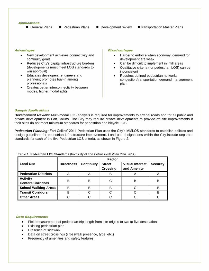
Development Review: Multi-modal LOS analysis is required for improvements to arterial roads and for all public and private development in Fort Collins. The City may require private developments to provide off-site improvements if their sites do not meet minimum standards for pedestrian and bicycle LOS. Pedestrian Planning: Fort Collins’ 2011 Pedestrian Plan uses the City’s MMLOS standards to establish policies and design guidelines for pedestrian infrastructure improvement. Land use designations within the City include separate standards for each of the five Pedestrian LOS criteria, as shown in Figure 2. Table 1: Pedestrian LOS Standards (from City of Fort Collins Pedestrian Plan, 2011)
Land Use
Factor
Directness Continuity Street
Crossing
Visual Interest
and Amenity
Security
Pedestrian Districts A A B A A
Activity
Centers/Corridors B B C B B
School Walking Areas B B B C B
Transit Corridors B C C C B
Other Areas C C C C C
Disadvantages
Harder to enforce when economy, demand for development are weak
Can be difficult to implement in infill areas
Qualitative criteria (for pedestrian LOS) can be inconsistent
Requires defined pedestrian networks, congestion/transportation demand management plan
Applications
General Plans Pedestrian Plans Development review Transportation Master Plans
Data Requirements
Field measurement of pedestrian trip length from site origins to two to five destinations.
Existing pedestrian plan
Presence of sidewalk
Data on street crossings (crosswalk presence, type, etc.)
Frequency of amenities and safety features