Embed Size (px)
DESCRIPTION
Fort Collins created MMLOS standards for its streets in the late 1990s and has continued to refine them. Fort Collins standards consider both route characteristics and land use characteristics; high-priority land uses, such as public schools, require higher LOS for pedestrian and bicycle modes.
Citation preview
Roadway
Functional
Classification
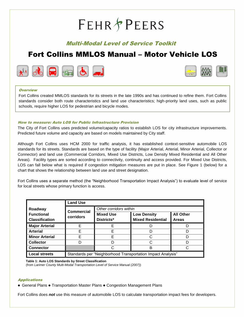
Land Use
Commercial
corridors
Other corridors within
Mixed Use
Districts*
Low Density
Mixed Residential
All Other
Areas
Major Arterial E E D D
Arterial E E D D
Minor Arterial E E C D
Collector D D C D
Connector C B C
Local streets Standards per “Neighborhood Transportation Impact Analysis”
How to measure: Auto LOS for Public Infrastructure Provision
The City of Fort Collins uses predicted volume/capacity ratios to establish LOS for city infrastructure improvements.
Predicted future volume and capacity are based on models maintained by City staff.
Although Fort Collins uses HCM 2000 for traffic analysis, it has established context-sensitive automobile LOS
standards for its streets. Standards are based on the type of facility (Major Arterial, Arterial, Minor Arterial, Collector or
Connector) and land use (Commercial Corridors, Mixed Use Districts, Low Density Mixed Residential and All Other
Areas). Facility types are sorted according to connectivity, continuity and access provided. For Mixed Use Districts,
LOS can fall below what is required if congestion mitigation measures are put in place. See Figure 1 (below) for a
chart that shows the relationship between land use and street designation.
Fort Collins uses a separate method (the “Neighborhood Transportation Impact Analysis”) to evaluate level of service
for local streets whose primary function is access.
Multi-Modal Level of Service Toolkit
Overview
Fort Collins created MMLOS standards for its streets in the late 1990s and has continued to refine them. Fort Collins
standards consider both route characteristics and land use characteristics; high-priority land uses, such as public
schools, require higher LOS for pedestrian and bicycle modes.
Applications
General Plans Transportation Master Plans Congestion Management Plans Fort Collins does not use this measure of automobile LOS to calculate transportation impact fees for developers.
Fort Collins MMLOS Manual – Motor Vehicle LOS
Table 1: Auto LOS Standards by Street Classification (from Larimer County Multi-Modal Transportation Level of Service Manual (2007))

Advantages
New development achieves connectivity and continuity goals
Reduces City’s capital infrastructure burdens (developments must meet LOS standards to win approval)
Educates developers, engineers and planners; promotes buy-in among professionals
Creates better interconnectivity between modes, higher modal splits
Disadvantages
Harder to enforce when economy, demand for development are weak
Can be difficult to implement in infill areas
Requires defined roadway networks, congestion/transportation demand management plan
Data Requirements (public infrastructure provision only)
Volume/Capacity calculations (based on existing conditions and projected land uses)
Land use plan (existing)
Transportation master plan (existing)