Embed Size (px)
Citation preview

Marbled Murrelet Long-Term Conservation Strategy FEIS Appendix D Page D-1
Appendix D
Occupied Sites Focus Paper
This focus paper was part of a series presented to the Board of Natural Resources (board) in October and
November 2015 to inform development of the marbled murrelet long-term conservation strategy alternatives.
The purpose of this focus paper is to describe the scientific methods used to identify sites occupied by marbled
murrelets (occupied sites) for purposes of protecting these sites
under the long-term conservation strategy.
What Are Occupied Sites?
Occupied sites represent the best information available to
DNR and USFWS about where murrelets might be nesting.
They are forested areas where evidence of either murrelet
nests, eggs, or chicks have been found or where murrelet
nesting behaviors have been observed.
Murrelet nests are difficult to find. A set of criteria is used in
the field to determine if a forest stand is likely to be used by
murrelets for nesting (refer to text box). Certain behaviors,
which have been documented at active nest sites, are used
during audio-visual survey as indicators of occupancy.1
These behaviors also have been associated with purposes
1 Only trained, certified murrelet surveyors are qualified to identify murrelet nesting evidence and behaviors.
Occupied Sites
Focus
Paper #4
Occupied sites are contiguous areas
of habitat where at least one of the
following occurs:
A murrelet nest is located.
Downy murrelet chicks or eggs or
egg shell fragments are found.
Marbled murrelets are detected
flying below, through, or into or
out of the forest canopy.
Marbled murrelets are heard
calling from a stationary location
within habitat.
Marbled murrelets are seen
circling above a stand within one
tree height of the top of the
canopy.

OCCUPIED SITES FOCUS PAPER
Marbled Murrelet Long-Term Conservation Strategy FEIS Appendix D Page D-2
other than attending an active nest, suggesting that the stand has some importance for breeding (Evans
Mack and others 2003).
Because of the difficulty in finding the specific tree within a forest stand that a marbled murrelet might be
using as a nest tree, most occupied sites are determined through observation of marbled murrelets flying
below, through, or into or out of the forest canopy, and/or marbled murrelets circling above a forest stand
within one tree height of the top of the canopy. This type of observation is documented as an “occupied
detection.” A majority of the occupied sites mapped on DNR-managed lands were identified through
occupied detections 2. Few occupied sites have been documented by finding the actual nest, murrelet
chicks or egg shell fragments, or by calling from a stationary location. Nest sites are confirmed only when
an actual nest is identified in a tree platform. Out of the 5,202 occupied detections in Washington State,
only 51 are associated with confirmed nests; of those, 13 are on DNR-managed lands.
Occupied behavior detection is a prudent approach to determining where murrelets are nesting. Although
scientific uncertainty exists (Plissner and others 2015, Oregon Department of Forestry 2019), there is
consistent evidence that occupied behaviors occur in the vicinity of known murrelet nest sites (Oregon
Department of Forestry 2019).
How Are Occupied Sites Delineated for Purposes of
Conservation Planning?
At the signing of DNR’s State Trust Lands Habitat Conservation Plan (1997 HCP), few occupied sites
had been identified and little was known about murrelet nesting habitat in Washington State, including on
DNR-managed lands. In granting DNR an incidental take permit for marbled murrelets, the U.S. Fish and
Wildlife Service (USFWS) agreed to an interim marbled murrelet conservation strategy (interim strategy)
to gather knowledge about marbled murrelet habitat needs before developing a long-term conservation
strategy. Part of this interim strategy included a habitat relationship study and an intensive survey
program of potential nesting habitat (DNR 1997). DNR’s survey program had begun in 1994, anticipating
the need for information about marbled murrelet occupancy for the development of an HCP. As a result of
the HCP survey effort, 397 occupied sites3, totaling approximately 43,000 acres, were identified on DNR-
managed lands. These occupied sites range in size from under 5 acres to 3,100 acres, and are between 0
and 53 miles from marine waters.
Occupied sites identified within the Straits, OESF, South Coast and Columbia HCP planning units were
reviewed and adjusted by a “Science Team” assembled in 2004 by DNR to develop recommendations for
marbled murrelet conservation (Raphael and others 2008). The Science Team recommended increasing
the total occupied site acres on DNR-managed lands to approximately 59,300 acres; this was an increase
of approximately 16,000 acres over what was delineated as occupied under the 1997 HCP, based on the
2 The Washington Department of Fish and Wildlife maintains a database of occupied detections. 3 Total generated through an objective and repeatable process DNR developed in 2019 to determine the number of occupied sites on DNR-managed lands. Refer to Appendix O for more information.
OCCUPIED SITES FOCUS PAPER
Marbled Murrelet Long-Term Conservation Strategy FEIS Appendix D Page D-3
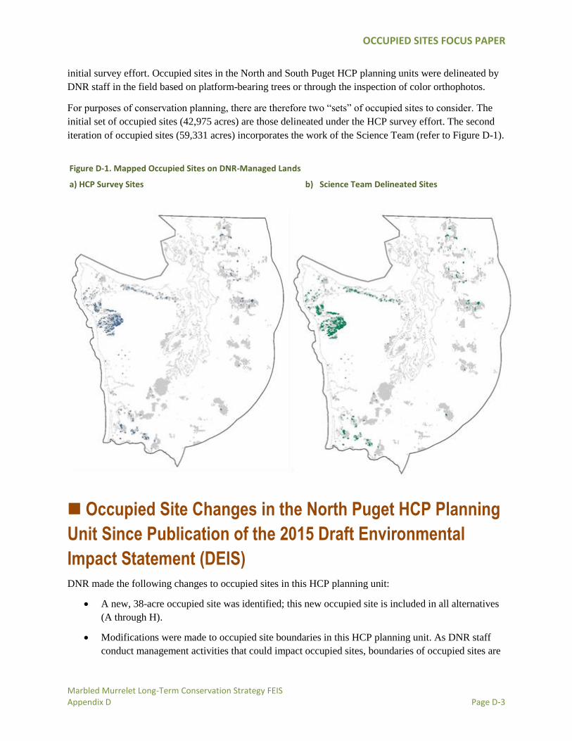
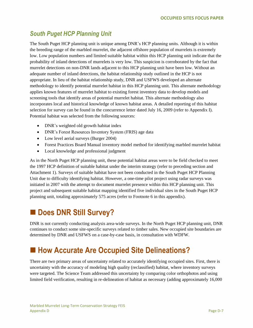
initial survey effort. Occupied sites in the North and South Puget HCP planning units were delineated by
DNR staff in the field based on platform-bearing trees or through the inspection of color orthophotos.
For purposes of conservation planning, there are therefore two “sets” of occupied sites to consider. The
initial set of occupied sites (42,975 acres) are those delineated under the HCP survey effort. The second
iteration of occupied sites (59,331 acres) incorporates the work of the Science Team (refer to Figure D-1).
Occupied Site Changes in the North Puget HCP Planning
Unit Since Publication of the 2015 Draft Environmental
Impact Statement (DEIS)
DNR made the following changes to occupied sites in this HCP planning unit:
A new, 38-acre occupied site was identified; this new occupied site is included in all alternatives
(A through H).
Modifications were made to occupied site boundaries in this HCP planning unit. As DNR staff
conduct management activities that could impact occupied sites, boundaries of occupied sites are
Figure D-1. Mapped Occupied Sites on DNR-Managed Lands
a) HCP Survey Sites b) Science Team Delineated Sites

OCCUPIED SITES FOCUS PAPER
Marbled Murrelet Long-Term Conservation Strategy FEIS Appendix D Page D-4
field verified to platform bearing trees and adjusted as required under a concurrence letter dated
February 23, 2007 (refer to Appendix I).
Occupied sites in this planning unit were not quantified correctly in the DEIS. The GIS data used
to identify occupied site boundaries resulted in an overestimate of occupied site acres. This issue
was addressed.
All changes combined resulted in an overall decrease of 1,746 acres of occupied sites in this HCP
planning unit. For maps of occupied sites and their associated buffers, refer to Appendix F.
How Did DNR Select Habitat to Survey?
The interim strategy focused DNR’s survey efforts on marbled
murrelet habitat known as “reclassified habitat;” refer to
Attachment 1 for a stepwise explanation of how this habitat was
defined.
Briefly, reclassified habitat was identified through the use of a
habitat relationship study predictive model (DNR 1999). Two
classes of habitat were identified based on this model:
1. Marginal habitat: Defined as those lands expected to contain a maximum of five percent of the
occupied sites on DNR-managed lands within each planning unit. These areas were made
available for harvest. All known occupied sites were deferred from harvest and were not included
in this habitat designation. Harvest of marginal habitat is permitted under the interim strategy
Incidental Take Permit.
2. Higher-quality habitat: Defined as those lands expected to contain at least 95 percent of the
occupied sites on DNR-managed lands within each HCP planning unit. This habitat is frequently
referred to as “reclassified habitat.”
The interim strategy directed DNR to survey all reclassified habitat acres using survey protocols
developed by the Pacific Seabird Group. Based on the observations made at each survey site, each
location within reclassified habitat would be determined to be “occupied” or “surveyed, unoccupied.”
Survey results were then submitted to Washington State Department of Fish and Wildlife (WDFW),
which is charged with stewarding all marbled murrelet survey data4.
4 Authority is granted to WDFW under WAC 222-16-010 *General definitions. “In determining the existence, location and status of occupied marbled murrelet sites, the department shall consult with the department of fish and wildlife and use only those sites documented in substantial compliance with guidelines or protocols and quality control methods established by and available from the department of fish and wildlife.”
“Reclassified habitat” is a term to
describe high quality marbled
murrelet habitat identified by
predictive models. This habitat was
expected to contain 95 percent of
the occupied sites found in surveys.

OCCUPIED SITES FOCUS PAPER
Marbled Murrelet Long-Term Conservation Strategy FEIS Appendix D Page D-5
How Did DNR Conduct Surveys?
Marbled murrelet surveys to identify occupied sites were conducted in each HCP planning unit between
1994 and 2009. Surveys were conducted according to inland survey protocols developed and updated by
the Pacific Seabird Group, Marbled Murrelet Technical Committee, or other methods approved by
USFWS5. These protocols were updated over time, with DNR using the most current protocol. Most
surveys were conducted for two years (usually five visits per year) or until murrelets were observed flying
within the forest canopy (in other words, occupied behavior); whichever was sooner. The layout of survey
sites and stations was planned by DNR staff using aerial photography and GIS mapping techniques.
Field-location of survey stations, and the actual murrelet surveys were conducted by several private
consulting firms (Resources Northwest, Inc.; Hamer Environmental; and Turnstone Environmental
Consultants, Inc.) with substantial review by the contractor and DNR staff. Survey results are summarized
in Table D-1.
Results
DNR completed marbled murrelet surveys for the South Coast and Columbia HCP planning units in 2002
and for the Straits HCP planning unit in 2003. The OESF inventory surveys were almost (80 percent)
complete in 2002 and were discontinued because DNR requested to USFWS that it was reasonable to
enter into the long-term planning process with the understanding that a multi-agency science team could
adequately develop a long-term conservation strategy without completing the surveys (DNR 2003). The
2008 Science Team Report considered unsurveyed acres in the broader context of its landscape scale
recommendations. The surveys were targeted to reclassified habitat identified through the habitat
relationship studies for these HCP planning units. Habitat was identified through an alternative process in
North and South Puget HCP planning units beginning in 2007. Results are summarized in Table D-1.
Table D-1. Survey Results Summary by Planning Unit
HCP Planning Unit Results
Approximate Acres of Habitat Identifieda
Approximate Surveyed Acres
Occupied Sites (in Acres)
Unsurveyed Acres
HCP Occupied Site Acres
Science Team Delineated Occupied
Site Acres
OESF 54,500 39,500 25,882b 39,611 15,000
Straits 15,600 15,600 3,942 5,661 0
South Coast and Columbia
27,000 27,000 8,741 9,656 0
5 Pacific Seabird Group survey protocols from Raphael and others (1994, 1995b, 1996, 1997, 1998) and Evans Mack and others
(2000, 2003). Sampling design approved by DNR and USFWS was used for habitat in natural resource conservation areas and
natural area preserves.

OCCUPIED SITES FOCUS PAPER
Marbled Murrelet Long-Term Conservation Strategy FEIS Appendix D Page D-6
HCP Planning Unit Results
North Puget 30,000
Note: “Suitable and
potential habitat”
17,500 3,834 3,834
c
South Pugetd 674
Note: “Suitable
habitat”
575 575 575 e
a Acres of high quality habitat were adjusted by the Science Team based on a review of the survey results and habitat relationship studies. b
Total occupied sites include those sites also identified by surveys conducted by WDFW in 2001and 2002 in response to the Tenyo Maru oil spill disaster. Protocols for the surveys conducted by WDFW are described in http://www.darrp.noaa.gov/northwest/tenyo/pdf/ten-mmfnl0203.pdf. c As of February 2014, in the North Puget HCP planning unit, 4,300 acres of identified "suitable habitat” remained unsurveyed. Also, 17,300 acres of “potential habitat” need to be field verified and classified as suitable habitat or unsuitable habitat. Based on previous field inspections of potential habitat, it is estimated that 30 to 50 percent of potential habitat in the North Puget HCP planning unit could be identified as suitable habitat. d All surveys in the South Puget HCP planning unit were conducted with radar. e There are 2,131 “potential habitat” acres identified through a methodology agreed to by USFWS and DNR.
North Puget HCP Planning Unit
In the case of the North Puget HCP planning unit, the reclassified habitat model did not perform well due
to the low number of occupied sites found in the habitat relationship study. Higher-quality marbled
murrelet habitat was discovered scattered throughout areas in this planning unit. These pockets of higher-
quality habitat were not identified by the reclassified habitat model, and thus were not scheduled to be
surveyed. USFWS and DNR agreed to a different approach to identifying habitat for the surveys (known
as “reclassified plus”). A detailed reporting of this habitat selection for survey can be found in the
concurrence letter dated February 23, 2007 (refer to Appendix I).
Briefly, all areas identified by various data sources (reclassified modeling efforts, local knowledge, and
professional judgment) were mapped as “potential habitat.” These potential habitat areas were field
checked to meet the 1997 HCP definition of suitable habitat (stands containing on average at least of two,
7-inch platforms per acre, greater or equal to five-acre patches, within 50 miles of marine water).6 If these
criteria were found on site, then the stand was scheduled for survey. Additionally, any new areas found to
meet the suitable habitat definition outside mapped potential habitat were not scheduled for survey, but
were deferred for consideration under the long-term conservation planning process. A total of 72
occupied sites7 were delineated through these survey efforts (refer to Table D-1).8
6 1997 HCP Chapter IV, pages 40-42. 7 The number of occupied sites is based on how they are delineated in DNR’s GIS data as of the date of this paper. 8 “Suitable habitat acres” is subject to change due to ongoing field work related to timber sales.
OCCUPIED SITES FOCUS PAPER
Marbled Murrelet Long-Term Conservation Strategy FEIS Appendix D Page D-7
South Puget HCP Planning Unit
The South Puget HCP planning unit is unique among DNR’s HCP planning units. Although it is within
the breeding range of the marbled murrelet, the adjacent offshore population of murrelets is extremely
low. Low population numbers and limited suitable habitat within this HCP planning unit indicate that the
probability of inland detections of murrelets is very low. This suspicion is corroborated by the fact that
murrelet detections on non-DNR lands adjacent to this HCP planning unit have been low. Without an
adequate number of inland detections, the habitat relationship study outlined in the HCP is not
appropriate. In lieu of the habitat relationship study, DNR and USFWS developed an alternate
methodology to identify potential murrelet habitat in this HCP planning unit. This alternate methodology
applies known features of murrelet habitat to existing forest inventory data to develop models and
screening tools that identify areas of potential murrelet habitat. This alternate methodology also
incorporates local and historical knowledge of known habitat areas. A detailed reporting of this habitat
selection for survey can be found in the concurrence letter dated July 16, 2009 (refer to Appendix I).
Potential habitat was selected from the following sources:
DNR’s weighted old growth habitat index
DNR’s Forest Resources Inventory System (FRIS) age data
Low level aerial surveys (Burger 2004)
Forest Practices Board Manual inventory model method for identifying marbled murrelet habitat
Local knowledge and professional judgment
As in the North Puget HCP planning unit, these potential habitat areas were to be field checked to meet
the 1997 HCP definition of suitable habitat under the interim strategy (refer to preceding section and
Attachment 1). Surveys of suitable habitat have not been conducted in the South Puget HCP Planning
Unit due to difficulty identifying habitat. However, a one-time pilot project using radar surveys was
initiated in 2007 with the attempt to document murrelet presence within this HCP planning unit. This
project and subsequent suitable habitat mapping identified five individual sites in the South Puget HCP
planning unit, totaling approximately 575 acres (refer to Footnote 6 in this appendix).
Does DNR Still Survey?
DNR is not currently conducting analysis area-wide surveys. In the North Puget HCP planning unit, DNR
continues to conduct some site-specific surveys related to timber sales. New occupied site boundaries are
determined by DNR and USFWS on a case-by-case basis, in consultation with WDFW.
How Accurate Are Occupied Site Delineations?
There are two primary areas of uncertainty related to accurately identifying occupied sites. First, there is
uncertainty with the accuracy of modeling high quality (reclassified) habitat, where inventory surveys
were targeted. The Science Team addressed this uncertainty by comparing color orthophotos and using
limited field verification, resulting in re-delineation of habitat as necessary (adding approximately 16,000
OCCUPIED SITES FOCUS PAPER
Marbled Murrelet Long-Term Conservation Strategy FEIS Appendix D Page D-8
acres). As described previously, uncertainties with the modeling efforts in the North Puget HCP planning
unit resulted in occupied sites being field-delineated in that HCP planning unit.
Second, there is some uncertainty built into the application of survey protocols. The protocols were
revised annually by the Pacific Seabird Group throughout and after the DNR surveys were conducted;
earlier surveys were not necessarily consistent with the most current protocols. The 2003 Pacific Seabird
Group survey protocols, which came out after DNR surveys under the interim strategy were concluded,
recommended that surveys take place over two consecutive years, because murrelets may occupy a site
one year and not the next. The revised protocol recommended a change from a minimum of four site
visits to five visits per year. Based on the 2003 protocol, the Science Team evaluated the older DNR
surveys and estimated potential error rates, making adjustments to recommended habitat conservation as
necessary (refer to Appendix F of Raphael and others 2008 for a detailed description).
How Does the Long-term Conservation Strategy Address
Occupied Sites?
Occupied site data are a key component of the habitat classification model being used under the analytical
framework for the long-term conservation strategy (refer to Appendix E, “P-stage Focus Paper”). For
purposes of the long-term conservation strategy, all survey-verified occupied sites are valued as high
quality habitat.
Occupied sites are variable; the structure, availability, and complexity of habitat varies across DNR-
managed lands within the range of the marbled murrelet, and the birds appear to use a range of habitat
quality. For example, although occupied sites were located in the high quality (reclassified) habitat in the
OESF HCP planning unit, even the marginal habitat in the OESF was of relatively higher quality
compared to habitat in other HCP planning units. The Straits HCP planning unit includes occupied sites
with little or no structure, perhaps because of a large, adjacent marine population of birds.
DNR has analyzed known occupied sites based on their size, number and type of detections, and forest
structure in order to rank these sites based on quality. All of the conservation approaches developed for
the long-term conservation strategy protect occupied sites, but with different strategies. Some alternatives
protect strategically located sites or groups of sites within larger habitat areas that include buffers and/or
security forests. Other alternatives focus conservation on the occupied sites as currently mapped. All of
the alternatives propose to include lands beyond occupied sites that provide marbled murrelet habitat
value (refer to Appendix G, “Long-term Forest Cover Focus Paper”).
OCCUPIED SITES FOCUS PAPER
Marbled Murrelet Long-Term Conservation Strategy FEIS Appendix D Page D-9
Attachment 1
The Reclassified Model Under the Interim Strategy The interim marbled murrelet strategy in the State Trust Lands Habitat Conservation Plan (1997 HCP)
provides five steps to guide DNR in protecting the marbled murrelet on DNR-managed lands in the area
covered by the 1997 HCP, while participating in collection of the information needed to develop a long-
term conservation strategy. DNR relied upon these steps to develop a “model” that predicts murrelet
occupancy at the forest stand level. The following information describes the steps that assisted DNR in
developing the long-term conservation strategy.
1. Defer Suitable Habitat Blocks
During development of the interim strategy in 1997, DNR and USFW agreed to a conservative definition
of suitable habitat, prior to developing the DNR predictive model. The conservative nature of the suitable
habitat definition was intended to ensure DNR avoided “take” of habitat prior to the completion of
predictive model. Once the predictive model was developed, it reclassified the definition of habitat from
suitable habitat to “Reclassified Habitat and Marginal Habitat.”
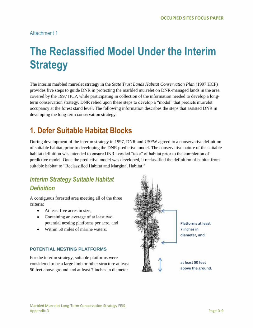
Interim Strategy Suitable Habitat
Definition
A contiguous forested area meeting all of the three
criteria:
At least five acres in size,
Containing an average of at least two
potential nesting platforms per acre, and
Within 50 miles of marine waters.
POTENTIAL NESTING PLATFORMS
For the interim strategy, suitable platforms were
considered to be a large limb or other structure at least
50 feet above ground and at least 7 inches in diameter.
Platforms at least
7 inches in
diameter, and
at least 50 feet
above the ground.
OCCUPIED SITES FOCUS PAPER
Marbled Murrelet Long-Term Conservation Strategy FEIS Appendix D Page D-10
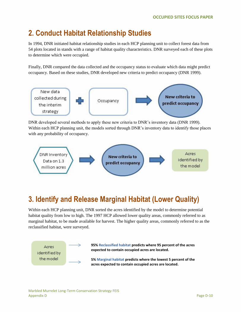
2. Conduct Habitat Relationship Studies
In 1994, DNR initiated habitat relationship studies in each HCP planning unit to collect forest data from
54 plots located in stands with a range of habitat quality characteristics. DNR surveyed each of these plots
to determine which were occupied.
Finally, DNR compared the data collected and the occupancy status to evaluate which data might predict
occupancy. Based on these studies, DNR developed new criteria to predict occupancy (DNR 1999).
DNR developed several methods to apply these new criteria to DNR’s inventory data (DNR 1999).
Within each HCP planning unit, the models sorted through DNR’s inventory data to identify those places
with any probability of occupancy.
3. Identify and Release Marginal Habitat (Lower Quality)
Within each HCP planning unit, DNR sorted the acres identified by the model to determine potential
habitat quality from low to high. The 1997 HCP allowed lower quality areas, commonly referred to as
marginal habitat, to be made available for harvest. The higher quality areas, commonly referred to as the
reclassified habitat, were surveyed.
95% Reclassified habitat predicts where 95 percent of the acres expected to contain occupied acres are located. 5% Marginal habitat predicts where the lowest 5 percent of the acres expected to contain occupied acres are located.

OCCUPIED SITES FOCUS PAPER
Marbled Murrelet Long-Term Conservation Strategy FEIS Appendix D Page D-11
4. Survey Reclassified Habitat (Higher Quality)
DNR conducted surveys on higher quality reclassified habitat.9
5. Develop a Long-term Conservation Strategy
The information obtained during the previous steps, as well as other research efforts, is being used to
develop a long-term conservation strategy within each HCP planning unit.
9 In accordance with the HCP, surveyed, unoccupied habitat outside of southwest Washington could be released for harvest if it is not within 0.5 mile of an occupied site and after harvest, at least 50 percent of the suitable marbled murrelet habitat on DNR-managed lands in the watershed administrative unit remained. Within southwest Washington, release of surveyed, unoccupied habitat is subject to the process used by DNR and USFWS to develop the long-term strategy (HCP pp. IV-40, step 4).

OCCUPIED SITES FOCUS PAPER
Marbled Murrelet Long-Term Conservation Strategy FEIS Appendix D Page D-12
Literature Cited Bradley, J.E. and J. M. Marzluff. 2003. Rodents as nest predators: Influences on predatory behavior and
consequences to nesting birds. Auk 120 4 1180
Evans Mack, D., W. P. Ritchie, S. K. Nelson, E. Kuo-Harrison, P. Harrison and T. E. Hamer. 2003. Methods for
surveying marbled murrelets in forests, a revised protocol for land management and research. Pacific Seabird Group,
Marbled Murrelet Technical Committee. Technical Publication Number 2. Available from
http://www.pacificseabirdgroup.org.
Horton, S. 2008. Ecology and conservation of marbled murrelets on the Western Olympic Peninsula: Temporal and
spatial variation in inland activity and implications for forest management. University of Washington Ph.D thesis
Lance, M.M. and S. F. Pearson. 2005. At-sea marbled murrelet population monitoring. Washington Department of
Fish and Wildlife, Olympia, WA
Luginbuhl, J.M., J.M. Marzluff, J. E. Bradley, M. G. Raphael and D. E. Varland. 2001. Corvid survey techniques
and the relationship between corvid relative abundance and nest predation. Journal of Field Ornithology 7:2 4 556
Marzluff, J.M., J. M. Luginbuhl, J. E. Bradley, M. G. Raphael, D. M. Evans and D. Varland. 1999. The influence of
stand structure, proximity to human activity, and forest fragmentation on the risk of predation to nests of marbled
murrelets on the Olympic Peninsula: Annual report, June 25th, 1999
Marzluff, J.M., M. G. Raphael and R. Sallabanks. 2000. Understanding the effects of forest management on avian
species. Wildlife Society Bulletin 28 4 1132
Oregon Department of Forestry. 2019. Marbled murrelet technical report—final. April 24, 2109. Developed by
Jennifer Weikel, Private Forest Program. Oregon Department of Forestry, Salem, Oregon. 41 p.
Plissner, J. H., B. Cooper, R. H. Day, P. M. Sanzenbacher, and ABR, Inc. 2015. A review of marbled murrelet
research related to nesting habitat use and nest success. Prepared for Oregon Department of Forestry, Salem,
Oregon. 32 p.
Thompson, C.W. 1999. Distribution and abundance of marbled murrelets and common murres on the outer coast of
Washington—summer 1997 through winter 1998-1999. Washington Department of Fish and Wildlife, Olympia,
WA
Ralph, C. J., S. K. Nelson, M. M. Shaughnessy, S. L. Miller, and T. E. Hamer. 1994. Methods for surveying for
marbled murrelets in forests — a protocol for land management and research. Pacific Seabird Group, Marbled
Murrelet Technical Committee. Technical paper No. 1, revision. 48 pp. Available from USDA Forest Service,
Redwood Sciences Laboratory, 1700 Bayview Dr., Arcata, CA.
Ralph, C. J., S. K. Nelson, S. L. Miller, and T. E. Hamer. March 8, 1995. Letter to marbled murrelet surveyors and
managers providing additions to the 1994 inland survey protocol. Pacific Seabird Group, Marbled Murrelet
Technical Committee, Inland Survey Protocol Subcommittee. 5 pp. + attachments. Available from USDA Forest
Service, Redwood Sciences Laboratory, 1700 Bayview Dr., Arcata, CA.
Ralph, C. J., S. K. Nelson, S. L. Miller, and T. E. Hamer. April 24, 1996. Letter to marbled murrelet surveyors and
managers providing clarification and updates for the 1994 protocol and 1995 protocol letter. Pacific Seabird Group,

OCCUPIED SITES FOCUS PAPER
Marbled Murrelet Long-Term Conservation Strategy FEIS Appendix D Page D-13
Marbled Murrelet Technical Committee, Inland Survey Protocol Subcommittee. 2 pp. Available from USDA Forest
Service, Redwood Sciences Laboratory, 1700 Bayview Dr., Arcata, CA.
Ralph, C. J., S. K. Nelson, S. L. Miller, and T. E. Hamer. April 24, 1997. Letter to marbled murrelet surveyors and
managers providing clarification and updates for the 1994 protocol and subsequent protocol letters. Pacific Seabird
Group, Marbled Murrelet Technical Committee, Inland Survey Protocol Subcommittee. 2 pp. Available from USDA
Forest Service, Redwood Sciences Laboratory, 1700 Bayview Dr., Arcata, CA.
Ralph, C. J., S. K. Nelson, S. L. Miller, and T. E. Hamer. March 11, 1998. Letter to marbled murrelet surveyors and
managers providing clarification and updates for the 1994 protocol and subsequent protocol letters. Pacific Seabird
Group, Marbled Murrelet Technical Committee, Inland Survey Protocol Subcommittee. 2 pp. Available from USDA
Forest Service, Redwood Sciences Laboratory, 1700 Bayview Dr., Arcata, CA.
Raphael, M. G., S. K. Nelson, P. Swedeen, M. Ostwald, K. Flotlin, S. Desimone, S. Horton, P. Harrison, D. P.
Escene and W. Jaross. 2008. Recommendations and supporting analysis of conservation opportunities for the
marbled murrelet conservation strategy (Science Team Report). Washington State Department of Natural Resources,
Olympia, WA.
Washington State Department of Natural Resources. 1997. Final Habitat Conservation Plan. Olympia, WA.
Washington State Department of Natural Resources. February 23, 2007. North Puget planning unit interim strategy.
Letter to Ken Berg, USFWS.
Washington Department of Natural Resources. 1999. Marbled murrelet forest habitat relationships studies.
Developed by Danielle Prenzlow-Escene, Resource Planning and Asset Management. Washington Department of
Natural Resources, Olympia, WA. 79 p.
Washington State Department of Natural Resources. July 16, 2009. Final SPPU murrelet habitat identification
concurrence letter. Letter to Ken Berg, USFWS.
Washington State Department of Natural Resources. April 8, 2003. Letter from DNR to USFWS, re: Discontinuing
surveys in the OESF.


![FEIS TableOfContents[1]](https://img.pdfslide.us/doc/110x75/577d366b1a28ab3a6b9308e2/feis-tableofcontents1.jpg)