Embed Size (px)
Citation preview

!
!P
!
!
!
!
!
! !
!
!
!
!
!!
!
!
!
!
!
!
!
!
!P
!
!
!
!
!
!
!
!
!
!
!
!
!
!
!
!
!
!
!
!
South Point SMR
Santa BarbaraIsland SMR
JudithRock SMR
PyramidHead SMR
Land'sEnd SMR
Palos Verdes SMR
CarpinteriaSalt Marsh SMR
MuguLagoon SMR
Newport Bay SMR
Carpinteria SMR
Cardiff SMR
San Elijo Lagoon SMR
Orange County SMR
MalibuSMR
Devereux Lagoon SMRGoleta Slough SMR
BatiquitosLagoon SMR
Begg Rock SMR
TajiguasSMR
ChinaPoint SMR
NorthEnd SMR
Catalina North SMR
San Diego Bay SMP
Goleta SMR
Pt Conception SMR
Bolsa Chica SMR
Long Pt SMRFarnsworthBank SMR
LechuzaSMP
RefugioSMP
Pt MuguSMCA
Imperial Beach SMR
Richardson Rock SMR HarrisPoint SMR
Gull Island SMR
CarringtonPoint SMR
PaintedCave SMCA Scorpion
SMR AnacapaIsland SMCA
Anacapa Island SMR
Footprint SMRSkunk
Point SMR
Tijuana Estuary SMR
West San Nicolas SMR
Pt Loma SMR
La Jolla SMR
Agua Hedionda SMR
Huntington Beach
Riverside
Lancaster
Palmdale
Santa Clarita
Simi Valley
Thousand Oaks Burbank
Inglewood
Long Beach
Pasadena
Anaheim CoronaFullerton
Ontario
Orange
Pomona
Santa Ana
San Bernardino
Escondido
Oceanside
Santa BarbaraCarpinteria
Oxnard
Santa Monica
Hermosa Beach
Palos Verdes Estates
Newport BeachLaguna Beach
San Clemente
Carlsbad
Encinitas
Del Mar
Coronado
Imperial Beach
Malibu
Ventura
Mira Monte
Lompoc
Los Angeles
San Diego
MexicoMexico117°30'0"W118°20'0"W119°10'0"W120°0'0"W
34°1
0'0"N 34°1
0'0"N
33°2
0'0"N 33°2
0'0"N
32°3
0'0"N 32°3
0'0"N
MLPA South Coast Study Region: Round 1 - Draft External Proposal C
Name: NAD 1983 California Teale Albers Projection: Albers Datum: North American 1983
1:1,400,000±0 7.5 153.75 MilesProjection Information: Printing Date: 2/26/2009
Created By: Marine Map, Cartographic Division UCSB
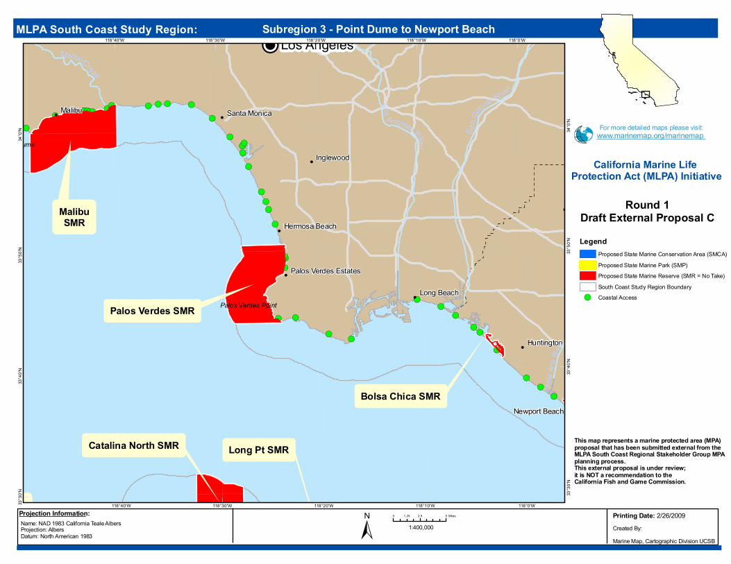
LegendProposed Marine Protected Areas
Proposed State Marine Conservation Area (SMCA)
Proposed State Marine Park (SMP)
Proposed State Marine Reserve (SMR = No Take)South Coast Study Region Boundary
This map represents a marine protected area (MPA) proposal that has been submitted external from theMLPA South Coast Regional Stakeholder Group MPA planning process. This external proposal is under review; it is NOT a recommendation to the California Fish and Game Commission.
For more detailed maps please visit:www.marinemap.org/marinemap
California Marine Life Protection Act (MLPA) Initiative

Data Sources: California Department of Fish and Game
!
!
!
!(!(!(
!(!( !(
!(!(!(
!( !( !(!(!(!(
!( !(!(
!(
!
!
!
JudithRock SMR
CarpinteriaSalt Marsh SMR
Carpinteria SMR
Devereux Lagoon SMR Goleta Slough SMR
TajiguasSMR
Goleta SMR
Pt Conception SMR
RefugioSMP
Richardson Rock SMR
HarrisPoint SMR
CarringtonPoint SMR
PaintedCave SMCA
ScorpionSMR Anacapa
Island SMCA
Anacapa Island SMR
Footprint SMR
SkunkPoint SMR
Santa BarbaraCarpinteria
LompocEast Fork Sant.
Cruz Crk
.
Sisquoc R iver
Santa Cruz Creek
Santa Ynez River
Mono Creek
San Antonio Creek
Santa Ynez River
Rincon Point
Goleta Point
Point Conception
119°50'W
119°50'W
120°10'W
120°10'W
119°30'W
119°30'W
119°40'W
119°40'W
120°0'W
120°0'W
120°20'W
120°20'W
120°30'W
120°30'W
34°4
0'N
34°4
0'N
34°3
0'N
34°3
0'N
34°2
0'N
34°2
0'N
34°1
0'N
34°1
0'N
34°0
'N
34°0
'N
Name: NAD 1983 California Teale Albers Projection: Albers Datum: North American 1983
1:500,000±0 3 61.5 MilesProjection Information:
LegendProposed State Marine Conservation Area (SMCA)Proposed State Marine Park (SMP)Proposed State Marine Reserve (SMR = No Take)South Coast Study Region Boundary
!( Coastal Access
MLPA South Coast Study Region: Subregion 1 - Government Point to Rincon Point
Round 1Draft External Proposal C
This map represents a marine protected area (MPA) proposal that has been submitted external from theMLPA South Coast Regional Stakeholder Group MPA planning process. This external proposal is under review; it is NOT a recommendation to theCalifornia Fish and Game Commission.
For more detailed maps please visit:www.marinemap.org/marinemap
Printing Date: 2/26/2009Created By: Marine Map, Cartographic Division UCSB
California Marine Life Protection Act (MLPA) Initiative

Data Sources: California Department of Fish and Game
!
!
!
!
!(
!( !(!(!( !(!(!(
!( !(!(!(!(!(
!( !( !(
!(!(
!(
!(!(
!(
!(!(
!(
!(
!(
!(
!(!(!(
!(!(
!
!
!
!
!
!
!
!
CarpinteriaSalt Marsh SMR
MuguLagoon SMR
Carpinteria SMR
MalibuSMR
LechuzaSMP
Pt MuguSMCA
Gull Island SMR
ScorpionSMR Anacapa
Island SMCA
Anacapa Island SMR
Footprint SMR
Simi Valley
Thousand Oaks
Santa BarbaraCarpinteria
Oxnard
Port Hueneme
Ventura
Mira Monte
Malibu
Piru Creek
Ses pe
Cree
k
Ca llegu
as Cree
k
Santa C lara River
Arroyo Las Posas
Arroyo Simi
Ventur a Riv er
Santa C la ra River
Point Dume
Point Mugu
Point Hueneme
Rincon Point
119°30'W
119°30'W
118°50'W
118°50'W
119°0'W
119°0'W
119°10'W
119°10'W
119°20'W
119°20'W
34°2
0'N
34°2
0'N
34°1
0'N
34°1
0'N
34°0
'N
34°0
'N
Name: NAD 1983 California Teale Albers Projection: Albers Datum: North American 1983
1:350,000±0 2 41 MilesProjection Information:
LegendProposed State Marine Conservation Area (SMCA)Proposed State Marine Park (SMP)Proposed State Marine Reserve (SMR = No Take)South Coast Study Region Boundary
!( Coastal Access
MLPA South Coast Study Region: Subregion 2 - Rincon Point to Point Dume
Round 1Draft External Proposal C
This map represents a marine protected area (MPA) proposal that has been submitted external from theMLPA South Coast Regional Stakeholder Group MPA planning process. This external proposal is under review; it is NOT a recommendation to theCalifornia Fish and Game Commission.
For more detailed maps please visit:www.marinemap.org/marinemap
Printing Date: 2/26/2009Created By: Marine Map, Cartographic Division UCSB
California Marine Life Protection Act (MLPA) Initiative
Data Sources: California Department of Fish and Game
!
!
!(
!(!(
!(
!(
!(!(
!( !(
!(!(
!(!(
!(
!(!(!(
!(
!(!(
!(
!(
!(!(
!(!(
!(
!(!(
!( !(!(!(!(!(!(
!( !(!( !( !( !( !(
!
!P
!
!
!
!
!
!
!
!
!
!
!
!
Land'sEnd SMR
Palos Verdes SMR
Newport Bay SMR
Orange County SMR
MalibuSMR
Catalina North SMR
Bolsa Chica SMR
Long Pt SMR
Thousand Oaks Burbank
Inglewood
Long Beach
Pasadena
Anaheim
Fullerton
Orange
Santa Ana
Irvine
Santa Monica
Hermosa Beach
Palos Verdes Estates
Newport Beach
Huntington Beach
Malibu
Los Angeles
Santa
Ana R
iver
Malibu C reek
Los
Angeles River
San G
abriel Rive r
Palos Verdes Point
Point Dume
118°0'W
118°0'W
118°10'W
118°10'W
118°20'W
118°20'W
118°30'W
118°30'W
118°40'W
118°40'W
34°0
'N 34°0
'N
33°5
0'N 33°5
0'N
33°4
0'N 33°4
0'N
33°3
0'N 33°3
0'N
Name: NAD 1983 California Teale Albers Projection: Albers Datum: North American 1983
1:400,000±0 2.5 51.25 MilesProjection Information:
LegendProposed State Marine Conservation Area (SMCA)Proposed State Marine Park (SMP)Proposed State Marine Reserve (SMR = No Take)South Coast Study Region Boundary
!( Coastal Access
MLPA South Coast Study Region: Subregion 3 - Point Dume to Newport Beach
Round 1Draft External Proposal C
This map represents a marine protected area (MPA) proposal that has been submitted external from theMLPA South Coast Regional Stakeholder Group MPA planning process. This external proposal is under review; it is NOT a recommendation to theCalifornia Fish and Game Commission.
For more detailed maps please visit:www.marinemap.org/marinemap
Printing Date: 2/26/2009Created By: Marine Map, Cartographic Division UCSB
California Marine Life Protection Act (MLPA) Initiative
Data Sources: California Department of Fish and Game
!
!
!(
!(!(
!(
!(!(
!(
!(!(
!(
!(
!(
!(
!(!(
!(!(
!(
!(!(!(!(
!(!(
!(
!(!
!
!
!
!
!
!
!
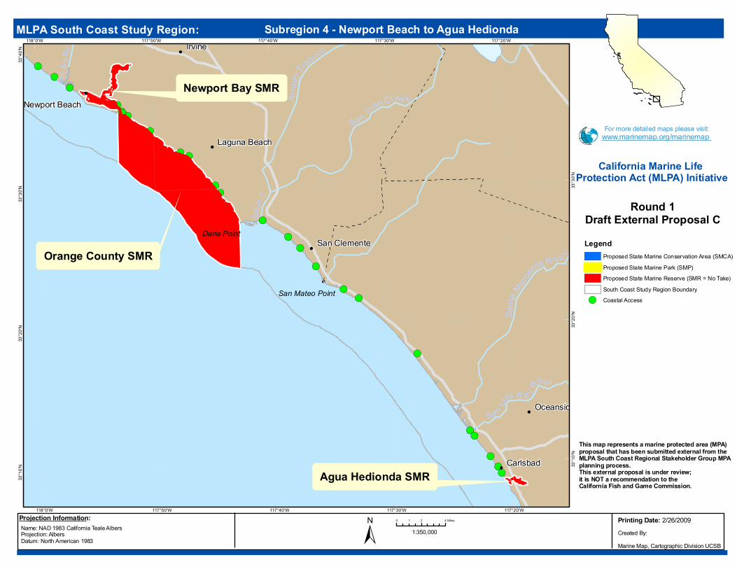
Newport Bay SMR
Orange County SMR
BatiquitosLagoon SMR
Bolsa Chica SMR
Agua Hedionda SMR
Long Beach
Santa Ana
Irvine
Oceanside
Newport Beach
Laguna Beach
San Clemente
Carlsbad
Huntington Beach
Solana Beach
Encinitas
Santa
Margarita
Riv e r
Sa n Jn. C
.
Snt. An
a Rv r.
San Luis R e y R
ive r
Arroy
o Trabuco
San Juan Cree k
San Mateo Point
Dana Point
117°20'W
117°20'W
117°30'W
117°30'W
117°40'W
117°40'W
117°50'W
117°50'W
118°0'W
118°0'W
33°4
0'N33
°30'N
33°3
0'N
33°2
0'N
33°2
0'N
33°1
0'N 33°1
0'N
Name: NAD 1983 California Teale Albers Projection: Albers Datum: North American 1983
1:350,000±0 2 41 MilesProjection Information:
LegendProposed State Marine Conservation Area (SMCA)Proposed State Marine Park (SMP)Proposed State Marine Reserve (SMR = No Take)South Coast Study Region Boundary
!( Coastal Access
MLPA South Coast Study Region: Subregion 4 - Newport Beach to Agua Hedionda
Round 1Draft External Proposal C
This map represents a marine protected area (MPA) proposal that has been submitted external from theMLPA South Coast Regional Stakeholder Group MPA planning process. This external proposal is under review; it is NOT a recommendation to theCalifornia Fish and Game Commission.
For more detailed maps please visit:www.marinemap.org/marinemap
Printing Date: 2/26/2009Created By: Marine Map, Cartographic Division UCSB
California Marine Life Protection Act (MLPA) Initiative
Data Sources: California Department of Fish and Game
!
!
!(
!(
!(!(
!(
!(!(!(
!(!(
!(!(!(
!(
!(
!(!(
!(!(
!(!(
!(!(!(!(
!(
!(!(
!(!(
!(
!
!
!P
!
!
!
!
!
!
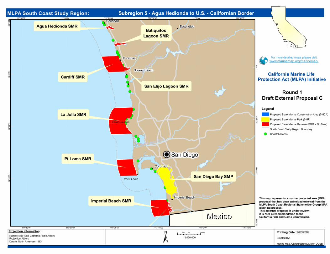
Cardiff SMRSan Elijo Lagoon SMR
BatiquitosLagoon SMR
San Diego Bay SMP
Imperial Beach SMR
Tijuana Estuary SMR
Pt Loma SMR
La Jolla SMR
Agua Hedionda SMR Escondido
Oceanside
Carlsbad
Solana Beach
Coronado
Imperial Beach
Encinitas
San Diego
San Die
gt. River
San Di egu
ito
Rive r
Otay R ive r
Santa Ysabel Cr eek
S weet
w ater Riv e r
Esc ondid o Creek
San Diego Rive r
Point Loma
Point La Jolla
MexicoMexico116°50'W
116°50'W
117°0'W
117°0'W
117°10'W
117°10'W
117°20'W
117°20'W
117°30'W
117°30'W
117°40'W
117°40'W
33°1
0'N33
°0'N
33°0
'N
32°5
0'N
32°5
0'N
32°4
0'N
32°4
0'N32
°30'N
Name: NAD 1983 California Teale Albers Projection: Albers Datum: North American 1983
1:420,000±0 2.5 51.25 MilesProjection Information:
LegendProposed State Marine Conservation Area (SMCA)Proposed State Marine Park (SMP)Proposed State Marine Reserve (SMR = No Take)South Coast Study Region Boundary
!( Coastal Access
MLPA South Coast Study Region: Subregion 5 - Agua Hedionda to U.S. - Californian Border
Round 1Draft External Proposal C
This map represents a marine protected area (MPA) proposal that has been submitted external from theMLPA South Coast Regional Stakeholder Group MPA planning process. This external proposal is under review; it is NOT a recommendation to theCalifornia Fish and Game Commission.
For more detailed maps please visit:www.marinemap.org/marinemap
Printing Date: 2/26/2009Created By: Marine Map, Cartographic Division UCSB
California Marine Life Protection Act (MLPA) Initiative

Data Sources: California Department of Fish and Game
!
!
!
!
!(
!( !(!(!(
!( !(!(!(!(!(
!(!(
!( !(
!(!(!(
!(
!(
!(
!(
!(!(!(
!(!(
!
!
!
!
!
!
South Point SMR
JudithRock SMR
CarpinteriaSalt Marsh SMR
Carpinteria SMR
Devereux Lagoon SMR Goleta Slough SMR
Begg Rock SMR
TajiguasSMR
Goleta SMR
Pt Conception SMR
RefugioSMP
Richardson Rock SMR
HarrisPoint SMR
Gull Island SMR
CarringtonPoint SMR
PaintedCave SMCA
ScorpionSMR Anacapa
Island SMCA
Anacapa Island SMR
Footprint SMR
SkunkPoint SMR
Santa BarbaraCarpinteria
Oxnard
Port Hueneme
Ventura
Mira Monte
Snt. Clr . Rvr .
Mtl. Cr.
Vent
ura R iv e
r
Goleta Point
Point Conception
Point Hueneme
Rincon Point
119°50'W
119°50'W
120°10'W
120°10'W
119°20'W
119°20'W
119°30'W
119°30'W
119°40'W
119°40'W
120°0'W
120°0'W
120°20'W
120°20'W
120°30'W
120°30'W120°40'W
34°3
0'N
34°2
0'N
34°2
0'N
34°1
0'N
34°1
0'N
34°0
'N
34°0
'N
33°5
0'N
33°5
0'N
33°4
0'N
33°4
0'N
33°3
0'N
33°3
0'N
Name: NAD 1983 California Teale Albers Projection: Albers Datum: North American 1983
1:650,000±0 4 82 MilesProjection Information:
LegendProposed State Marine Conservation Area (SMCA)Proposed State Marine Park (SMP)Proposed State Marine Reserve (SMR = No Take)South Coast Study Region Boundary
!( Coastal Access
MLPA South Coast Study Region: Subregion 6 - Northern Channel Islands
Round 1Draft External Proposal C
This map represents a marine protected area (MPA) proposal that has been submitted external from theMLPA South Coast Regional Stakeholder Group MPA planning process. This external proposal is under review; it is NOT a recommendation to theCalifornia Fish and Game Commission.
For more detailed maps please visit:www.marinemap.org/marinemap
Printing Date: 2/26/2009Created By: Marine Map, Cartographic Division UCSB
California Marine Life Protection Act (MLPA) Initiative

Data Sources: California Department of Fish and Game
!(!(
!(!(
!(
!
Santa BarbaraIsland SMR
PyramidHead SMR
Land'sEnd SMR
Palos Verdes SMR
Begg Rock SMR
ChinaPoint SMR
NorthEnd SMR
Catalina North SMR
Bolsa Chica SMR
Long Pt SMR
FarnsworthBank SMR
West San Nicolas SMR
Long Beach
Palos Verdes Estates
119°40'W
119°40'W
118°20'W
118°20'W
118°30'W
118°30'W
118°40'W
118°40'W
118°50'W
118°50'W
119°0'W
119°0'W
119°10'W
119°10'W
119°20'W
119°20'W
119°30'W
119°30'W
33°4
0'N 33°4
0'N
33°3
0'N 33°3
0'N
33°2
0'N 33°2
0'N
33°1
0'N 33°1
0'N
33°0
'N 33°0
'N
32°5
0'N 32°5
0'N
32°4
0'N 32°4
0'N
Name: NAD 1983 California Teale Albers Projection: Albers Datum: North American 1983
1:700,000±0 4 82 MilesProjection Information:
LegendProposed State Marine Conservation Area (SMCA)Proposed State Marine Park (SMP)Proposed State Marine Reserve (SMR = No Take)South Coast Study Region Boundary
!( Coastal Access
MLPA South Coast Study Region: Subregion 7 - Santa Catalina and Santa Barbara Islands
Round 1Draft External Proposal C
This map represents a marine protected area (MPA) proposal that has been submitted external from theMLPA South Coast Regional Stakeholder Group MPA planning process. This external proposal is under review; it is NOT a recommendation to theCalifornia Fish and Game Commission.
For more detailed maps please visit:www.marinemap.org/marinemap
Printing Date: 2/26/2009Created By: Marine Map, Cartographic Division UCSB
California Marine Life Protection Act (MLPA) Initiative