Embed Size (px)
Citation preview

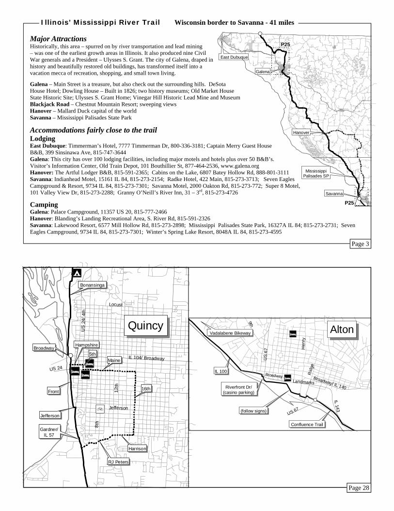
Major Attractions: Alton - Alton Museum of History and Art; Confederate Cemetery; Confederate Prison; Lovejoy Monument, Alton Cemetery; Piasa Bird, On River Bluff, 1 Mile West of Alton, Visitors Center on IL 100; Robert Wadlow Monument; Lincoln-Douglas, Broadway and Landmarks; National Great Rivers Museum at Lock 26 Hartford - Lewis and Clark State Historic Site Interpretive Center, IL 3 at Poag Rd Collinsville - Cahokia Mounds Cahokia - Historic Cahokia Courthouse, Martin-Boismenue House / Jarrot Mansion
Accommodations fairly close to the trail: Lodging: Alton: Comfort Inn, 11 Crossroads Ct, 618-465-9999; Days Inn, 1900 Homer Adams Pkwy 618-463-0800; Beall Mansion B & B, 407 E. 12th St, 618-474-9100, 800-990-2325; Holiday Inn, 3800 Homer Adams Pkwy, 618-462-1220; Jackson House B & B, 1821 Seminary St, 618-462-1426, 800-462-1426; Super 8 Hotel, 1800 Homer Adams Pkwy, 618-465-8885; Tiffany Inn B & B, 410 E. Broadway, 618-462-4145 Granite City: Best Western Camelot Inn, 1240E Old Chain Of Rocks Rd, 618-931-2262; Relax Inn, 1100 Niedringhaus Ave, 618-877-7100; Land of Lincoln Motel, 3220 W. Chain Of Rocks Rd, 618-931-1414; Canal Motel, 3317 W. Chain Of Rocks Rd, 618-931-0744 East St. Louis: Casino Queen Hotel and Casino, 200 Front St, 800-777-0777 Cahokia: Trails End Motel, 600 Water St, 618-337-2010
Camping: Granite City: KOA Campground, 3157 W. Chain of Rocks Rd, 618-931-5160 East St. Louis: Casino Queen RV Park, 200 Front St, 800-777-0777 Cahokia: Cahokia RV Park, IL 3 & IL 157, 618-332-9700
This segment predominately uses Illinois highways. Illinois 57 is scenic but can be busy, others have low traffic. The detour to Hannibal, Boyhood Home of Mark Twain, uses the only Interstate Highway in Illinois permitting bikes. It’s hilly getting into and out of town on the Missouri side.
Food: Quincy (CS), Hull (C), Kinderhook (S), New Canton (CS), Atlas (CS), Pleasant Hill (CS)
Bicycle Repair: Quincy: Madison & Davis Bicycle Shop, 912 S. 8th St, 217-222-7262
Emergency Information: State Police: Dist 20, 217-285-4431
Cue Sheet - Quincy to Pleasant Hill, 53 miles Start: Quincy—Broadway and Front St
Go Dir On Miles Total (See Page 12 for scenic tour of Quincy—alternative route)
S Front.............................................................. 1.0 1.0 L E Jefferson (no sign)......................................... 0.0 1.0 R S Gardner Expy/ IL57- Caution: heavy (N) to moderate (S) traffic, trucks................................11.5 12.5 R S/W Fall Creek Rd/ 1100E.................................... 5.2 17.7 L SE IL 106 - Hull - F&D...................................... 8.3 26.0 E IL 96............................................................... 1.2 27.2 R S IL 96/ IL106 - Kinderhook - F&D............... 1.6 28.8 R SE IL 96 - New Canton - F&D........................... 5.6 34.4 SE IL 96 - Atlas - F&D..................................... 11.0 45.4 Lodging in Louisiana, MO, 6.5 miles SE IL 96 - Pleasant Hill - F&D.......................... 7.1 52.5
IL 96 Quincy St & Main St - Pleasant Hill
To Hannibal, Missouri from Fall Creek Rd and IL106
L E IL 106............................................................. 0.2 0.2 R SW I-72 (shoulder)............................................... 1.0 1.2 R W Off-ramp to MO 79....................................... 0.3 1.5 L SE MO 79 becomes 3rd St.................................. 1.0 2.2
Hannibal - Left on Hill St, one block to Main St historic sites
#S
#S
East Alton
Wood River
Hartford
PontoonBeach
Madison
Cahokia
Edwardsville
Alton
Granite City
Venice
Brooklyn
E. St. Louis
Dupo
Sauget
Illinois’ Mississippi River Trail Alton to Dupo (Metro East Area) - 34 miles
Page 17
Page 14
P29
P29
P29
P28
#S
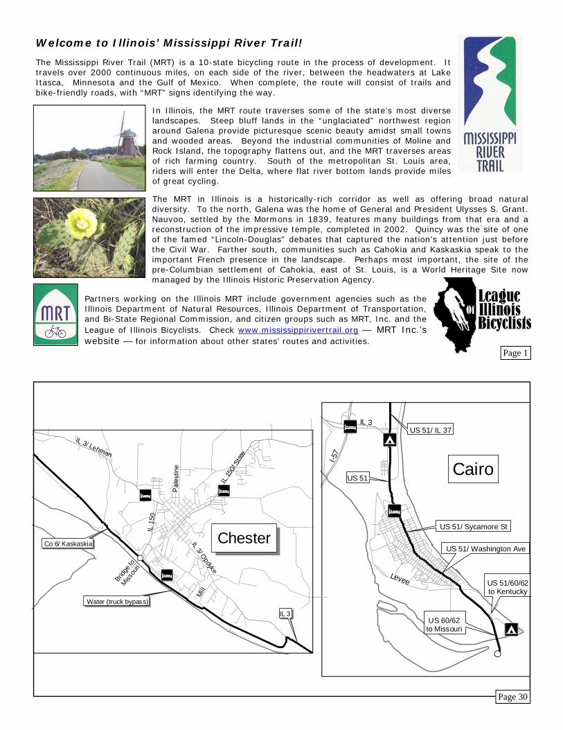
#SChester
Dupo
Columbia
Valmeyer
Maeystown
Prairie du Rocher
Chester
Fults
Modoc
EllisGrove
Major Attractions: Geography is the pull here. On one side, an encompassing flood plain stretches flatly as far as the eye can see to the Missouri bluffs on the far side of the majes-tic Mississippi. On the other side, sometimes so close you can almost touch it, the river bluff soars to towering heights, spinning raptors and verdant vegetation from its sheer limestone cliffs.
Fults – Fults Hill Prairie Nature preserve Prairie du Rocher – Fort de Chartres, circa 1753 Modoc – Modoc Ferry to Sainte Genevieve, MO Modoc Rock Shelter – a cave providing shelter since 8000 BC Ellis Grove – Fort Kaskaskia – the earthworks remain Pierre Menard Home – early 1800s mansion of 1st Lt. Governor Chester – Chester River Bridge and Popeye statue; Randolph County Museum; Kaskaskia Island – Illinois on the western shore of the Misssissippi
Accommodations fairly close to the trail: Lodging: Maeystown: Corner George Inn B&B, 1101 Main St, 618-458-6660 Prairie du Rocher: La Maison du Rocher Country Inn B&B, Duclos and Main Sts., 618-284-3463 Sainte Genevieve, MO: Wilmar Motel, 370 Sainte Genevieve Dr, 573 - 883-2702; Hotel Ste. Genevieve, N. Main & Merchant, 573 - 883-3562; Family Budget Inn, 17030 New Bremen Rd, 573-543-2272 Chester: Hi 3 Motel, 827 Lehman Dr, 618-826-4415; Reid’s Inn Best Western, 2150 State St, 618-826-3034; The Stone House B&B, 509 W. Harrison St, 618-604-9106
Camping: Ellis Grove: Fort Kaskaskia Historic Campground, 4372 Park Rd, 618-859-3741 Chester: Randolph County Conservation Area, 4301 S. Lake Dr, 618-826-2706
Illinois’ Mississippi River Trail Dupo to Chester - 61 miles
Food: Nauvoo (CS), Warsaw (CS), Ursa (C off route), Quincy (CS)
Bicycle Repair: Quincy: Madison & Davis Bicycle Shop, 912 S. 8th St, 217-222-7262
Emergency Information: Hospital: Dial 911 State Police: State Police: Hancock County, 309-833-4046, Adams County, 217-285-4431
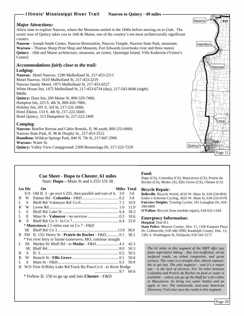
Cue Sheet - Nauvoo to Quincy, 49 miles Start: Nauvoo—IL 96 Mulholland St and Durphy St
Go Dir On Miles Total S Durphy St/ IL 96 - Caution traffic, especially summer weekends .................... 11.8 11.8 R SW US 136 - Hamilton -F&D (off route)- heavy traffic... 0.6 12.4 * To Keokuk, IA (F&D) - Continue 1.3 miles west on US136
L S Co 32/ Warsaw-Hamilton Rd (stop light, no sign)...... 4.9 17.3 R W Main St (stop light, no sign) - Warsaw - F&D............ 0.4 17.7 L S Water/ Co 11...............................................................20.2 37.9 * Ferry, Meyer to Canton, MO, 6.2 miles west at 15.6 miles (8 a.m. to 5 p.m.)
L E 2150th (no sign, stop sign) F&D off route in Ursa...... 1.2 39.1 R S Co 7/ Bonansinga ........................................................ 9.8 48.9 L E Broadway..................................................................... 0.0 48.9
Broadway & Front - Quincy - F&D
Scenic Tour of Quincy Route (Adds 2.5 miles to direct Route) R S Front St......................................................................... 0.2 0.2 L E Hampshire (2nd street after bridge overhead).............. 0.3 0.5 R S 5th St - move to left lane.............................................. 0.1 0.6 L E Maine............................................................................ 1.0 1.6 R S 16th St.......................................................................... 1.3 2.9 R W Harrison ....................................................................... 0.3 3.2 W R J Peters...................................................................... 1.0 4.2 L S Gardner Expressway
Page 19
Page 12
From Nauvoo to Hamilton, Route 96 gives great views of the river and has many turn-offs, which may be welcome after dealing with the hills. Narrow shoulders are fairly consistent southbound; less so northbound. It’s bottomland on the 31 miles between Warsaw and Quincy, with no services but very quiet riding.
P29
P30
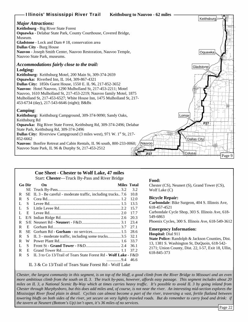
The route is straight and flat in the Big River State Forest between Keithsburg and Oquawka. Between US 34 and Lomax, enjoy nice riding through farmland with many turns that provide a change from the flat, straight routes closer to the river. Between Dallas City and Nauvoo, the route again takes lower trafficked roads inland with a few hills.
Food: Keithsburg (CS), Oquawka (CS), Lomax (C), Dallas City (C), Nauvoo (CS)
Bicycle Repair: West Burlington, IA: Bickel's Fit-ness & Cycling, 305 E. Agency Rd W, 319-754-4410
Emergency Information: State Police: Dist 14, 309-833-4046
R S 870E....................................................... 2.2 29.7 R W 900N...................................................... 0.5 30.2 L S 750E....................................................... 1.5 31.7 L E 750N....................................................... 0.5 32.2 R S 800E....................................................... 1.8 34.0 R W 575N...................................................... 0.2 34.2 L S 775E....................................................... 2.7 36.9 R W 300N/ IL 96........................................... 0.9 37.8 Junction IL 522 - Lomax - F&D
SW IL 96/ 2nd St.......................................... 4.8 42.6 R W Toward Dallas City Park....................... 0.2 42.8 L W/SW 1st St - Dallas City - F&D.................... 1.1 43.9 * Bridge to Ft. Madison, IA, at Niota, 6 mi west of Dallas City
L S Oak St/ IL 9........................................... 3.1 47.0 S E 1800 (not marked).............................. 1.0 48.0 R W N 2600................................................... 0.5 48.5 L S E 1760 - Colusa - no services............... 1.0 49.5 R W N 2500/ N2450/ Co 2............................. 9.9 59.4 L S E 800...................................................... 0.5 59.9 R W IL 96/ Mulholland St.............................. 2.1 62.0
IL 96 Mulholland St & Durphy St - Nauvoo - F&D
#S
#S
Gorham
Wolf Lake
GrandTower
Neunert
Cora
To Murphysboroand Carbondale
ChesterMajor Attractions: Chester – Chester River Bridge and Popeye statue Randolph County Museum Kaskaskia Island – Illinois on the western shore of the Misssissippi Shawnee National Forest – 27,700 unglaciated acres of woods and small farms and towns Grand Tower – Devil’s Backbone Park, with the Devil’s Bake Oven (caves); Oakwood Bottoms – trails, bluffs, and the LaRue Swamp
Accommodations fairly close to the trail: Lodging: Chester: Hi 3 Motel, 827 Lehman Dr, 618-826-4415; Reid’s Inn Best Western, 2150 State St, 618-826-3034; The Stone House B&B, 509 W. Harrison St, 618-604-9106 Murphysboro (10 miles from route): Apple Tree Inn, 200 N. 2nd St, 618-687-2345 Super 8 Motel, 128 E Walnut St, 618-687-2244
Camping: Cora – Gorham: Johnson Creek, north on IL 151, 618-687-4914 Murphysboro (10 miles from route): Kinkaid Lake Village Marina, 2063 Marina Rd, 618-687-4914; Lake Murphysboro State Park, 52 Cinder Hill Dr, 618-684-2867 Grand Tower: Devil’s Backbone Park Campground, Brunkhorst Ave at Grand Tower Rd, 618-565-2454; Turkey Bayou/ Oakwood Bottoms, east on 800N, 618-687-1731 Wolf Lake: Pine Hills, east on Co 13, 618-833-8576
Illinois’ Mississippi River Trail Chester to Wolf Lake - 47 miles
Cue Sheet - Keithsburg to Nauvoo, 62 miles Start: Keithsburg - 4th St and Main St
Go Dir On Miles Total L E Main St, Keithsburg............................. 0.3 0.3 R S 10th St/ Co 25/ Keithsburg Rd/ Co 3....10.0 10.3 R W 2225N toward Delabar State Park......... 0.5 10.8 L S 3rd St..................................................... 1.8 12.6 * Mississippi River two short blocks to right L E Schuyler - Oquawka - F&D................. 0.4 13.0 R S IL 164/ 8th St........................................ 4.8 17.8 * Henderson Covered Bridge 2.5 mi. south R W/S To Lock and Dam/ Co 15/ 1600N - Gladstone - no services.................................................. 3.2 21.0 L S 900E/ Co 15........................................... 3.0 24.0 R W/S 1300N.................................................... 1.0 25.0 R W US 34 - Take care: heavy traffic, including some trucks ............................................................... 0.5 25.5 Many turns next 12 miles, but low traffic L S 800E...................................................... 0.9 26.4 R S 825E...................................................... 0.7 27.1 L E 1100N.................................................... 0.4 27.5
Page 21
Page 10
P30
#S
#S
WolfLake
Trail of Tears SF
Jonesboro Anna
Tamms
OliveBranch
Mounds
MoundCity
Cairo
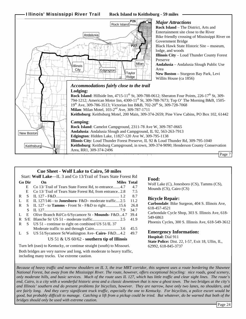
Much of this segment is ideal biking territory: low trafficked country roads that are flat and scenic. The Rock River crossing and the sections through Milan, however, are somewhat demanding because of high traffic and minimal shoulders. Be very cautious. Be also cautious about water and food, since there are no services between Edgington and New Boston, about 30 miles, unless you go across the river to Muscatine, Iowa.
Food: Rock Island (CS), Milan (CS), Edgington (CS), New Boston (CS), Keithsburg (CS)
Bicycle Repair: Rock Island: Bike & Hike, 3913-14th Ave, 309-788-2092 Muscatine, Iowa – across bridge: Harper’s Cy-cling, 1106 Grandview Ave, 563-263-4043
Emergency Information: Hospital: Dial 911 State Police: Dist. 7, 800 Hillcrest Rd, East Moline, 309-752-4915
Cue Sheet - Rock Island to Keithsburg, 59 miles Start: Rock Island - Great River Trail & Government Bridge
Use the Government Bridge to go across the Rock Island Arsenal to Iowa. At this point the east-west American Discovery Trail meets the MRT.
Go Dir On Miles Total SW Great River Trail - downtown left one block - F&D........... 0.4 0.4 SW Great River Trail .................................................................. 3.0 3.4 L E 31st Ave - moderate traffic.................................................... 1.0 4.4 R S 9th St - moderate traffic - F&D.............................................. 1.0 5.4 * Black Hawk State Historical Site, half mile to the left on Black Hawk Rd R S/E IL 67/ 1st Ave - Milan - F&D.............................................. 1.1 6.5 Go over Rock River Bridge - Very heavy traffic - Take caution R S 4th St (a one-way street) - heavy traffic................................. 0.8 7.3 R W 10th Ave/78th Ave/Andalusia Rd - Use caution, very busy...0.7 8.0 L S Ridgewood Rd/ Co 62 (cross 92nd Ave/Milan Beltway)...... 4.0 12.0 R W/S IL 94/ IL 192 - to Taylor Ridge............................................ 3.5 15.5 W IL 192 to Edgington - F&D.................................................. 5.0 20.5 W IL 192 to hard right................................................................ 2.4 22.9 R N IL 192..................................................................................... 0.9 23.8 * Scenic Loud Thunder Co. Forest Pres. - F&D (seasonal) - further N on IL 192 L W IL 92 - to Illinois City .......................................................... 4.7 28.5 W IL 92....................................................................................... 5.8 34.3 * Mississippi River bridge to Muscatine, Iowa - 2 miles further W on IL 92 L S Co 11/ Co 14.........................................................................15.9 50.2 L E Co 17 - New Boston 1.5 miles south on Co 17 - F&D......... 0.3 50.5 E Co 17..................................................................................... 2.5 53.0 R S Keithsburg Rd/ 76th St/ 4th St - Keithsburg - F&D............ 6.0 59.0
4th St & Main St - Keithsburg
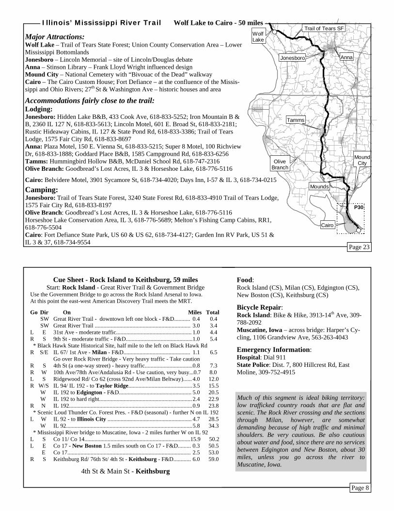
Cairo: Belvidere Motel, 3901 Sycamore St, 618-734-4020; Days Inn, I-57 & IL 3, 618-734-0215
Camping: Jonesboro: Trail of Tears State Forest, 3240 State Forest Rd, 618-833-4910 Trail of Tears Lodge, 1575 Fair City Rd, 618-833-8197 Olive Branch: Goodbread’s Lost Acres, IL 3 & Horseshoe Lake, 618-776-5116 Horseshoe Lake Conservation Area, IL 3, 618-776-5689; Melton’s Fishing Camp Cabins, RR1, 618-776-5504 Cairo: Fort Defiance State Park, US 60 & US 62, 618-734-4127; Garden Inn RV Park, US 51 & IL 3 & 37, 618-734-9554
Major Attractions: Wolf Lake – Trail of Tears State Forest; Union County Conservation Area – Lower Mississippi Bottomlands Jonesboro – Lincoln Memorial – site of Lincoln/Douglas debate Anna – Stinson Library – Frank Lloyd Wright influenced design Mound City – National Cemetery with “Bivouac of the Dead” walkway Cairo – The Cairo Custom House; Fort Defiance – at the confluence of the Missis-sippi and Ohio Rivers; 27th St & Washington Ave – historic houses and area
Accommodations fairly close to the trail: Lodging: Jonesboro: Hidden Lake B&B, 433 Cook Ave, 618-833-5252; Iron Mountain B & B, 2360 IL 127 N, 618-833-5613; Lincoln Motel, 601 E. Broad St, 618-833-2181; Rustic Hideaway Cabins, IL 127 & State Pond Rd, 618-833-3386; Trail of Tears Lodge, 1575 Fair City Rd, 618-833-8697 Anna: Plaza Motel, 150 E. Vienna St, 618-833-5215; Super 8 Motel, 100 Richview Dr, 618-833-1888; Goddard Place B&B, 1585 Campground Rd, 618-833-6256 Tamms: Hummingbird Hollow B&B, McDaniel School Rd, 618-747-2316 Olive Branch: Goodbread’s Lost Acres, IL 3 & Horseshoe Lake, 618-776-5116
Illinois’ Mississippi River Trail Wolf Lake to Cairo - 50 miles
Page 23
Page 8
P30

Detailed Inset Maps
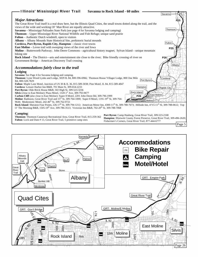
The vision of the MRT is an uninterrupted off-road trail as close as possible to the banks of the Mississippi – and in this segment that vision approaches reality. Most of the 60 miles are on the well-marked Great River Trail, with numerous food and drink stops, and it’s just about as flat as a floodplain can get.
Food: Savanna (CS), Spring Lake (S), Thomson (CS), Fulton (CS), Albany (CS), Cordova (C), Port Byron (CS), Rapids City (CS), Hampton (CS), E. Moline (CS), Moline (CS), Rock Island (CS) Bicycle Repair: Savanna: Arnold’s Bicycle Repair, 319 Main St, 815-273-7789 Clinton, Iowa – across from Fulton: River City Bike Shop, 131-5th Ave, 563-243-8000 Rock Island: Bike & Hike,3913-14th Ave, 309-788-2092
Cue Sheet - Savanna to Rock Island, 60 miles Start: Savanna - Great River Trail & IL 84
Go Dir On Miles Total S Great River Trail…………………………………..........3.2 3.2 R S IL 84 - moderate traffic, heavy at times…...................... 1.4 4.6 R W/S Riverview Rd………………………………………...... 4.5 9.1 * Visit the Fish & Wildlife interpretive center L E Sandpatch Rd…………………………………….......... 0.5 9.6 R S Sandridge Rd………………………………………… 1.0 10.6 L E Main St - Thomson (straight ahead) - F&D……….... 0.1 10.7 R S Lewis Ave (unmarked)………………..…….………. 0.4 11.1 L S enter Thomson Sand Prairie Trail…………………… 2.0 13.1 R/L S Unmarked road - after quick right & left……………. 2.1 15.2 L/R S Great River Trail - after quick left and right………… 2.7 17.9 * Watch for Great River Trail signs from here to Rock Island. R W 9th Ave - Fulton - F&D…….………………………. 1.1 19.0 R N 2nd St…..……………………………………………. 0.1 19.1 L W/S Levee path……………………………………..…….. 0.8 19.9 * IL 136 Bridge to Clinton, Iowa R S Path next to road…………………………………...… 1.4 21.3 S On-road - cross RR tracks - follow signs to levee path.. 0.7 22.0 L S Levee Path …………………………………………….. 0.8 22.8 R S Ebson Rd (some gravel)………………………………. 1.3 24.1
L E/S Kennedy Rd/ Co 30 - cross IL 84 - keep to right……. 0.6 24.7 R S Ufkin Rd - some gravel……………………………… 0.5 25.2 R W Palmer Rd…………………………………………… 0.9 26.1 L SW Waller/ Bluff/ Church - Albany - F&D………………. 1.6 27.7 L SE 11th Ave…………………………………………….. 0.2 27.9 R S Path through Albany Mounds Historical Site……….. 0.7 28.6 The path meanders through burial mounds made by prehistoric people R/R N Meridosia Rd………………………...………………… 0.3 28.9 L S Great River Trail to Nuclear Plant exit………………… 6.1 35.0 S Trail - (path & road) to Kiosk - Cordova - F&D……… 2.9 37.9 S Trail - (on road) - to path entrance south of Cordova…. 1.0 38.9 S Trail - to Kiosk at riverfront - Port Byron - F&D…….. 4.6 43.5 S Trail - to Kiosk at riverfront - Rapids City - F&D……..1.8 45.3 SW Trail - to Kiosk at Illiniwek Park - D (seasonal)............. 3.5 48.8 SW Trail - to Kiosk at Hampton - F&D.............................. 1.1 49.9 SW Trail - to Kiosk at Empire Park - East Moline - F&D (seasonal)............................ 1.0 50.9 SW Trail - to Campbell's Island Rd........................................ 0.6 51.5 SW Trail - to Moline/East Moline border - F&D to south... 2.5 54.0 W Trail - to Kiosk, Butterworth Pky - Moline - seasonal D.. 1.1 55.1 W Trail - to Kiosk at John Deere Commons Area - F&D... 2.2 57.3 W Trail - to Government Bridge - Rock Island - F&D...... 2.7 60.0
Great River Trail & Government Bridge - Rock Island
Emergency Information: Hospital: Dial 911 State Police: Carroll and Whiteside Counties, Dist. 1, 3107 W. Lincolnway, Sterling, 815-632-4010; Rock Island County, Dist. 7, 800 Hillcrest Rd, East Moline, 309-752-4915
Æó
Æó
ÆQ
US 20
IL 84
Buckhill
Dewey
High Ridge W. Council Hill
N. Council Hill
Main
Rives
3rd
Blackjack
US 20/ IL 84
Franklin
US 20
Chetlain
US 20
Galena
ÆWÆW
ÆW
ÆWÆQ
ÆWÆó
#SIL 84/ Chicago
Scenic Ridge
5th
4th
Webster
IL 84
GreatRiverTrail
IL 84/Main
US 52(to Iowa)
Great River Trail
MississippiPalisades SP
IL 8
4
US 52/ IL 64
Savanna
Oakton
Dean
ÆW
IL 8
4
IL 136
US 30
Hazel
Garden PlainIL 84
4 th
9th
GreatRiverTrail
US 30
Ebso
n
Ward
31st
4th
IL 136
2nd
(follow signs)
Levee trail
Levee trail
Ebson
Kennedy
Ufkin
Fulton
Page 25
Page 6
Serious riders will enjoy the heart of the “Illinois Alps” in this stretch of the MRT. Geographically, much of the segment lies in the driftless, or unglaciated, area of northwestern Illinois. This is an area of crags, ravines, ridges – rugged topography not worn down and smoothed by the recent glaciers. One result is spectacular scenery – ridge-top views undu-lating with verdant landscapes capped by the Missis-sippi River in the distance. Another is challenging cycling. Derailleurs will be used. The true corridor of the MRT is, of course, right along the Mississippi’s shoreline, but these routes will always offer a strong rugged and scenic alternative.
Food is available at or near the following locations: (C-Convenience; S-Full Service) Galena (CS), Hanover (CS), Mississippi Palisades State Park (C-seasonal), Savanna (CS)
Bicycle Repair Galena: VeloCity Sports, 11400 US 20 W, 877-776-4386; Fever River Outfitters – bike rental, 216 - N Commerce St, 815-776-9425 Savanna: Arnold’s Bicycle Repair, 319 Main St, 815-273-7789
Emergency Information Hospital: Dial 911 State Police: Jo Daviess County, Dist. 16, 16450 W. State Rd, Pecatonica, 815-987-7156; Carroll County, Dist 1, 3107 W. Lincolnway, Sterling, 815-632-4010
Cue Sheet - Wisconsin border to Savanna, 41 miles Start: Wisconsin border - High Ridge Rd & Sinsinawa Rd
Go Dir On Miles Total S/E High Ridge Rd to W. Valley Rd intersection……………… 2.3 2.3 S/E High Ridge Rd…………………………………………….. 2.4 4.7 L N IL 84 - moderate traffic…………………………………….. 0.8 5.5 R E W. Council Hill Rd/ Co 1…….........…………………….. 1.5 7.0 R S N. Council Hill Rd/ Co 2…………….......………………… 2.3 9.3 R S Dewey/Broadway/Main St - downtown Galena - F&D…… 1.6 10.9 L E US 20 - Take care, heavy traffic…………………………… 0.3 11.2 R S 3rd St ………………………………………………….. 0.1 11.3 L E Rives St…………………………………………………….. 0.1 11.4 R SE Blackjack Rd/ Co 8 - scenic ridge road - very hilly……….15.1 26.5 R S IL 84 - to Hwy turning left………………………………… 0.3 26.8 L SE IL 84 - Hanover - to Jefferson Street - F&D…............…… 0.5 27.3 SE IL 84 - to Palisades State Park - F&D (seasonal)…………10.1 37.4 Take caution on IL 84 - moderate traffic S IL 84 - to Sabula Bridge to Iowa………………………….. 3.0 40.4 S IL 84………………………………………………………. 1.0 41.4 Main St/ IL 84 - Savanna - F&D
Alternate route - (6 miles longer) on the bluff, hilly, but avoids traffic on IL 84
Start: Hanover - IL 84 & Jefferson St
E Jefferson St………………………………………………………… 0.2 27.5 L N Plateau St………………………………………………………….. 0.1 27.6 R E Monroe St/ Hanover Rd/ Co 17 - two long hills…………………. 5.7 33.3 R S Derinda Rd/ Co 7……………………………………………...…. 2.9 36.2 R W/S Scenic Ridge Rte/ Co 9/ 5th St - Savanna…………..……………10.2 46.4 R W Webster St…………………………………………………………. 0.1 46.5 L S 4th St……………………………………………………………..… 0.6 47.1 R W Chicago Ave/ IL 84………………………………………………… 0.2 47.3 Main St/ IL 84 - Savanna - F&D
ÆW ÆWÆWÆW
ÆQ
#S
N 2450
E 800
IL 96
IL 96/ MulhollandIL 96/ Durphy Parley
Young
IL 96
NauvooÆW
ÆW
ÆW
Great River Trail
31st
9th
IL67
1st
4th
3rd
Ridgewood
Rock Island
Milan
10th/ 78th/ Andalusia
I-280
Big Island
IL 5
US
6 731st
92nd
4 th
US
6 7
17th18thIL
92 900E/ Co 15
1600N
1300N
US 34
800E
825E 1100N
870E900N
750E
750N 800E
575N775N
300E/ IL 96
HendersonCounty
#
Lomax
Car
man
I L 5
22
#
GulfPort
Page 27
Page 4
ÆW
Confluence Trail
ConfluenceTrail (end)
IL 3
McKinleyBridge
IL 3/ LincolnBroadway
IL 3/ 2nd
Granite City
Venice
Brooklyn
IL 3/ 4th
Madison
20th
Niedringhaus
Rock
North
Bissell
IL 203
Eagle Park
IL 3
ÆWÆQ
IL 3/ St. Clair
I-55-64-70/ IL3
I-55/7
0
I-64
Brooklyn
Sauget
9thBroadway
Mississippi
IL 3
I-55/70I L
3Fr
ont
8th
Trendley
Veterans MemorialEads
BroadwayMac Arthur
State
20th
10th
Monsanto
East St.Louis
8th
#S
StolleIL 3
State
I-255IL
3
I-255
I-255
5th
S. Main
N. Main
Old IL 3
Davis St Ferry
PalmerBluff
Old IL 3
IL 3
Columbia
Dupo
Page 29
About This Guide The Illinois’ Mississippi River Trail User Guide was produced by the League of Illinois Bicyclists (LIB) with the assistance of the Illinois Department of Natural Resources. It is intended to promote bicycle touring along the Mississippi River on a route suggested by LIB. Route selection was based on factors including proximity to the river, availability of off-road trails, roadway “bike-friendliness”, accommodations, and points of interest. Over time, the route will change as more off-road trails are built and improvements made to other roads. Check www.bikelib.org/mrt for the latest.
Using This Guide This booklet is divided into 11 segments of distances averaging 50-60 miles—possibly a day’s ride. Segment endpoints are chosen based on mileage and accommodations. Each segment includes an overall map (with inset maps at the back); major attractions; accommodations fairly close to the route; towns with food and drink; bike repair; emergency information, and a detailed north-to-south cue sheet with turns, road names, and mileages. (Check www.bikelib.org/mrt for south-to-north cue sheets, if needed.) Contact local tourism or convention & visitor bureaus for further information.
The cue sheet makes note of roads with more traffic. In general, “very heavy traffic” means over 12,000 vehicles per day on the road. “Heavy” means 12,000 to 6,000, and “Moderate” means 6,000 down to 3,000 or sometimes 2,000. Be safe out there—learn more about bike safety education at www.bikelib.org Acknowledgements
LIB volunteers and staff: Chuck Oestreich, Ann Schonlau, Al Sturges, Lee Pirtle, and Ed Barsotti. MRT, Inc: Pat Nunnally. Photos: Pat Nunnally and Mike Bentley. LIB would like to thank the Illinois Department of Natural Resources for its financial support of this project, as well as the other officials and volunteers who helped.
Page 2
User Guide 2004
Downloads and updates at www.bikelib.org/mrt
2550 Cheshire Dr. Aurora, IL 60504 www.bikelib.org
#S
#S
#S
#S
#S
#S
#S
#S
#S
#S
#S
#S
Illinois’ Mississippi
River Trail
#S
#S
#S
#S
#S
#S
#S
#S
#S
#S
#S
#S
Illinois’ Mississippi
River Trail
Illinois’ Mississippi River Trail
User Guide 2004
A touring guide for bicyclists and others
Explore Illinois’ 585 miles of roadways and paths, towns and countryside, natural sights, history, and Midwestern living—
all following America’s greatest waterway
Page 30
ÆQ
ÆW
ÆWÆQ
#S
I-57
IL 3US 51/ IL 37
US 51
US 51/ Sycamore St
US 60/62to Missouri
US 51/60/62to Kentucky
Levee
US 51/ Washington Ave
CairoÆW
ÆW
ÆW
#S
Co 6/ Kaskaskia
Water (truck bypass)
IL 3
Pal
e stin
e
IL 1
50/ S
tate
IL 3/ Opdyke
IL 3/ Lehman
IL 1
5 0
Bridge
toMiss
ouri
Chester
Mill
Welcome to Illinois’ Mississippi River Trail! The Mississippi River Trail (MRT) is a 10-state bicycling route in the process of development. It travels over 2000 continuous miles, on each side of the river, between the headwaters at Lake Itasca, Minnesota and the Gulf of Mexico. When complete, the route will consist of trails and bike-friendly roads, with “MRT” signs identifying the way.
In Illinois, the MRT route traverses some of the state’s most diverse landscapes. Steep bluff lands in the “unglaciated” northwest region around Galena provide picturesque scenic beauty amidst small towns and wooded areas. Beyond the industrial communities of Moline and Rock Island, the topography flattens out, and the MRT traverses areas of rich farming country. South of the metropolitan St. Louis area, riders will enter the Delta, where flat river bottom lands provide miles of great cycling. The MRT in Illinois is a historically-rich corridor as well as offering broad natural diversity. To the north, Galena was the home of General and President Ulysses S. Grant. Nauvoo, settled by the Mormons in 1839, features many buildings from that era and a reconstruction of the impressive temple, completed in 2002. Quincy was the site of one of the famed “Lincoln-Douglas” debates that captured the nation’s attention just before the Civil War. Farther south, communities such as Cahokia and Kaskaskia speak to the important French presence in the landscape. Perhaps most important, the site of the pre-Columbian settlement of Cahokia, east of St. Louis, is a World Heritage Site now managed by the Illinois Historic Preservation Agency.
Partners working on the Illinois MRT include government agencies such as the Illinois Department of Natural Resources, Illinois Department of Transportation, and Bi-State Regional Commission, and citizen groups such as MRT, Inc. and the League of Illinois Bicyclists. Check www.mississippirivertrail.org — MRT Inc.’s website — for information about other states’ routes and activities.
Page 1
#S
#S
East Dubuque
Hanover
MississippiPalisades SP
Galena
Savanna
Major Attractions Historically, this area – spurred on by river transportation and lead mining – was one of the earliest growth areas in Illinois. It also produced nine Civil War generals and a President – Ulysses S. Grant. The city of Galena, draped in history and beautifully restored old buildings, has transformed itself into a vacation mecca of recreation, shopping, and small town living.
Galena – Main Street is a treasure, but also check out the surrounding hills. DeSota House Hotel; Dowling House – Built in 1826; two history museums; Old Market House State Historic Site; Ulysses S. Grant Home; Vinegar Hill Historic Lead Mine and Museum Blackjack Road – Chestnut Mountain Resort; sweeping views Hanover – Mallard Duck capital of the world Savanna – Mississippi Palisades State Park
Accommodations fairly close to the trail Lodging East Dubuque: Timmerman’s Hotel, 7777 Timmerman Dr, 800-336-3181; Captain Merry Guest House B&B, 399 Sinsinawa Ave, 815-747-3644 Galena: This city has over 100 lodging facilities, including major motels and hotels plus over 50 B&B’s. Visitor’s Information Center, Old Train Depot, 101 Bouthillier St, 877-464-2536, www.galena.org Hanover: The Artful Lodger B&B, 815-591-2365; Cabins on the Lake, 6807 Batey Hollow Rd, 888-801-3111 Savanna: Indianhead Motel, 15161 IL 84, 815-273-2154; Radke Hotel, 422 Main, 815-273-3713; Seven Eagles Campground & Resort, 9734 IL 84, 815-273-7301; Savanna Motel, 2000 Oakton Rd, 815-273-772; Super 8 Motel, 101 Valley View Dr, 815-273-2288; Granny O’Neill’s River Inn, 31 – 3rd, 815-273-4726
Camping Galena: Palace Campground, 11357 US 20, 815-777-2466 Hanover: Blanding’s Landing Recreational Area, S. River Rd, 815-591-2326 Savanna: Lakewood Resort, 6577 Mill Hollow Rd, 815-273-2898; Mississippi Palisades State Park, 16327A IL 84; 815-273-2731; Seven Eagles Campground, 9734 IL 84, 815-273-7301; Winter’s Spring Lake Resort, 8048A IL 84, 815-273-4595
Æó
ÆQ
ÆWÆWÆW
#S
Bonansinga
Broadway
Front
Jefferson
Gardner/IL 57
5th
Hampshire
Maine
16th
Harrison
RJ Peters
US
24/
4th
Jefferson
IL 104/ Broadway
US 24
12th
Locust
8 th
QuincyÆW
ÆW
#S
US 67
US
67
IL 143
Broadway/ IL 140
IL 100
Confluence Trail
Riverfront Dr/(casino parking)
Rid
ge
Landmarks
Hen
r y
9th
Vadalabene Bikeway
(follow signs)
Alton
Broadway
Page 28
Illinois’ Mississippi River Trail Wisconsin border to Savanna - 41 miles
Page 3
P25
P25
#S
#S
Thomson
Port Byron
Rapids CityHampton
Cordova
Albany
Savanna
Rock IslandEast Moline
Moline
Fulton
Major Attractions The Great River Trail itself is a real draw here, but the Illinois Quad Cities, the small towns dotted along the trail, and the views of the wide and working Ol’ Man River are equally attractive. Savanna – Mississippi Palisades State Park (see page 4 for Savanna lodging and camping) Thomson – Upper Mississippi River National Wildlife and Fish Refuge; unique sand prairie Fulton – Authentic Dutch windmill, open to visitors Albany – Albany Mounds State Historical Site, prehistoric burial mounds Cordova, Port Byron, Rapids City, Hampton – classic river towns East Moline – Levee trail with sweeping views of the river and Iowa Moline – Butterworth Parkway; John Deere Commons—agricultural history magnet; Sylvan Island—unique mountain biking site Rock Island – The District—arts and entertainment site close to the river; Bike friendly crossing of river on Government Bridge – American Discovery Trail crossing Accommodations fairly close to the trail Lodging Savanna: See Page 4 for Savanna lodging and camping. Thomson: Lynn Wood Lynks and Lodge, 5029 IL 84, 800-596-6966; Thomson House Villager Lodge, 800 One Mile Rd, 800-328-7829 Fulton: Maple Lane Motel, Junction of US 30 & IL 36, 815-589-3038; Pine Motel, IL 84, 815-589-4847 Cordova: Leisure Harbor Inn B&B, 701 Main St, 309-654-2233 Port Byron: Olde Brick House B&B, 502 High St, 309-523-3236 Silvis (close to East Moline): Plaza Motel, 1320-1st Ave, 309-792-0677 Carbon Cliff (also close to East Moline): Super 8 Motel, 2201 John Deere Rd, 309-796-1999 Moline: Radisson, Great River Trail and 15th St, 309-764-1000; Super 8 Motel, 1191-19th St, 309-764-9644; Modernistic Motel, 242-46th St, 309-762-0721 Rock Island: Sheraton Four Points, 226-17th St, 309-794-1212; American Motor Inn, 4300-11th St, 309-788-7673; Hillside Inn, 4715-11th St, 309-788-0612; Top O’ The Morning B&B, 1505-19th Ave, 309-786-3513; Victorian Inn B&B, 702-20th St, 309-788-7068
Camping: Thomson: Thomson Causeway Recreational Area, Great River Trail, 815-259-362 Fulton: Lock and Dam # 13, Great River Trail, 5 primitive camp sites
Æó
ÆW
ÆW
ÆWÆW
ÆW
ÆWÆW
#S
I
I-74
US 67
US
67/
11t
h 38th
12th
7t h
IL 92
IL 92
IL 8
4
34th
18th
GRT: Empire Park
Great River Trail
GRT: Moline/E.MolineGRT: Gov't Bridge
30th
16th
53rd
19th
East MolineSilvis
MolineRock Island
Quad Cites
IL 92IL 92
17th
AccommodationsÆó Bike Repair ÆQ Camping ÆW Motel/Hotel
Port Byron: Camp Hauberg, Great River Trail, 309-523-2168 Hampton: Illiniwek County Forest Preserve, Great River Trail, 309-496-2620; Fishermen’s Corners, Great River Trail, 877-444-6777
Illinois’ Mississippi River Trail Savanna to Rock Island - 60 miles
Pae 26
IL 84
Kennedy
Ufkin
PalmerBluff
Church
Albany
Stone
Ufk
in
Bunker Hill
11th
AlbanyMounds
trail
Meridosia
GreatRiverTrail
5th
Albany
Page 26
Page 5
P26
P25
P26
P25
#S
#S
New Boston
EdgingtonIllinoisCity
Andalusia
TaylorRidge
Keithsburg
Rock Island
Milan
Accommodations fairly close to the trail Lodging: Rock Island: Hillside Inn, 4715-11th St, 309-788-0612; Sheraton Four Points, 226-17th St, 309-794-1212; American Motor Inn, 4300-11th St, 309-788-7673; Top O’ The Morning B&B, 1505-19th Ave, 309-786-3513; Victorian Inn B&B, 702-20th St, 309-728-7068 Milan: Milan Motel, 103-2nd Ave, 309-787-1711 Keithsburg: Keithsburg Motel, 200 Main, 309-374-2659; Pine View Cabins, PO Box 102, 61442
Camping: Rock Island: Camelot Campground, 2311-78 Ave W, 309-787-0665 Andalusia: Andalusia Slough and Campground, IL 92, 563-263-7913 Edgington: Hidden Lake, 11827-120 Ave W, 309-795-1138 Illinois City: Loud Thunder Forest Preserve, IL 92 & Loud Thunder Rd, 309-795-1040 Keithsburg: Keithsburg Campground, in town, 309-374-9090; Henderson County Conservation Area, RR1, 309-374-2496
Major Attractions Rock Island – The District, Arts and Entertainment site close to the River Bike friendly crossing of Mississippi River on Government Bridge Black Hawk State Historic Site – museum, lodge, and woods Illinois City – Loud Thunder County Forest Preserve Andalusia – Andalusia Slough Public Use Area New Boston – Sturgeon Bay Park, Levi Willits House (ca 1856)
Because of heavy traffic and narrow shoulders on IL 3, the true MRT corridor, this segment uses a route bordering the Shawnee National Forest, but away from the Mississippi River. The route, however, offers exceptional bicycling: nice roads, good scenery, only moderate hills, and basic services. Much of the route uses IL 127, which has little traffic and clear sight lines. The route’s end, Cairo, is a city with a wonderful historic area and a classic downtown that is now a ghost town. The two bridges at the city’s and Illinois’ southern end do present problems for bicyclists, however. They are narrow, have only two lanes, no shoulders, and are fairly long. And they carry significant truck traffic, especially the one to Kentucky. For bicyclists, a police escort would be good, but probably difficult to manage. Catching a lift from a pickup could be tried. But whatever, do be warned that both of the bridges should only be used with extreme caution.
Food: Wolf Lake (C), Jonesboro (CS), Tamms (CS), Mounds (CS), Cairo (CS) Bicycle Repair: Carbondale: Bike Surgeon, 404 S. Illinois Ave, 618-457-4521 Carbondale Cycle Shop, 303 S. Illinois Ave, 618-549-6863 Phoenix Cycles, 300 S. Illinois Ave, 618-549-3612 Emergency Information: Hospital: Dial 911 State Police: Dist. 22, I-57, Exit 18, Ullin, IL, 62992, 618-845-3737
Cue Sheet - Wolf Lake to Cairo, 50 miles Start: Wolf Lake—IL 3 and Co 13/Trail of Tears State Forest Rd
Go Dir On Miles Total E Co 13/ Trail of Tears State Forest Rd, to entrance....... 4.7 4.7 E Co 13/ Trail of Tears State Forest Rd, from entrance.. 2.8 7.5 R S IL 127 - F&D............................................................... 1.2 8.7 L E IL 127/146 - to Jonesboro- F&D– moderate traffic.... 2.5 11.2 R S IL 127 - to Tamms - Front St - F&D to right .............15.6 26.8 S IL 127........................................................................... 7.9 34.7 L E Olive Branch Rd/Co 6/Sycamore St - Mounds- F&D...4.7 39.4 R S/E Blanche St/ US 51 - moderate traffic........................... 2.5 41.9 R S US 51 - continue to right on combined US 51/IL 37 Moderate traffic to and through Cairo.......................... 3.6 45.5 L S US 51/Sycamore St/Washington Ave- Cairo- F&D.... 4.2 49.7
US 51 & US 60/62 - southern tip of Illinois
Turn left (east) to Kentucky, or continue straight (south) to Missouri.
Both bridges are very narrow and long, with moderate to heavy traffic, including many trucks. Use extreme caution.
Page 24
Illinois’ Mississippi River Trail Rock Island to Keithsburg - 59 miles
Page 7
P27
P26
#S
#S
Keithsburg
Oquawka
Dallas City
Lomax
Gladstone
Colusa
Nauvoo
Chester, the largest community in this segment, is on top of the bluff, a good climb from the River Bridge to Missouri and an even more ambitious climb from the south on IL 3. The truck by-pass, however, affords easy passage. This segment includes about 20 miles on IL 3, a National Scenic By-Way which at times carries heavy traffic. It’s possible to avoid IL 3 by going inland from Chester through Murphysboro, but this does add miles and, of course, is not near the river. An interesting mid-section explores the Mississippi River flood plain in detail. Cyclists can almost become a part of the river, traversing a vast, fertile flatland between towering bluffs on both sides of the river, yet secure on very lightly traveled roads. But do remember to carry food and drink: if the tavern at Neunert (Bottom’s Up) isn’t open, it’s 36 miles of no services.
Food: Chester (CS), Neunert (S), Grand Tower (CS), Wolf Lake (C)
Bicycle Repair: Carbondale: Bike Surgeon, 404 S. Illinois Ave, 618-457-4521 Carbondale Cycle Shop, 303 S. Illinois Ave, 618-549-6863 Phoenix Cycles, 300 S. Illinois Ave, 618-549-3612
Emergency Information: Hospital: Dial 911 State Police: Randolph & Jackson Counties, Dist. 13, 1381 S. Washington St, DuQuoin, 618-542-2171; Union County, Dist. 22, I-57, Exit 18, Ullin, 618-845-373
Cue Sheet - Chester to Wolf Lake, 47 miles Start: Chester—Truck By-Pass and River Bridge
Go Dir On Miles Total SE Truck By-Pass.............................................................. 3.2 3.2 R SE IL 3 - Be careful - moderate traffic, including trucks.. 7.6 10.8 R S Cora Rd........................................................................ 1.2 12.0 L S Levee Rd...................................................................... 1.5 13.5 L S Little Levee Rd............................................................. 2.2 15.7 L E Levee Rd...................................................................... 2.0 17.7 L E/S Indian Ridge Rd........................................................... 2.6 20.3 R S/E Neunert Rd - Neunert - F&D...................................... 3.1 23.4 R E Gorham Rd................................................................... 3.7 27.1 R SE Gorham Rd - Gorham - no services............................ 1.5 28.6 R S IL 3 - moderate traffic, including some trucks............. 3.5 32.1 R W Power Plant Rd............................................................ 1.6 33.7 L S Front St - Grand Tower - F&D.................................. 2.4 36.1 R E Grand Tower Rd.......................................................... 1.1 37.2 R S IL 3 to Co 13/Trail of Tears State Forest Rd - Wolf Lake - F&D .............. 9.4 46.6
IL 3 & Co 13/Trail of Tears State Forest Rd - Wolf Lake
Major Attractions: Keithsburg - Big River State Forest Oquawka - Delabar State Park, County Courthouse, Covered Bridge, Museum. Gladstone - Lock and Dam # 18, conservation area Dallas City - Burg House Nauvoo - Joseph Smith Center, Nauvoo Restoration, Nauvoo Temple, Nauvoo State Park, museums.
Accommodations fairly close to the trail: Lodging: Keithsburg: Keithsburg Motel, 200 Main St, 309-374-2659 Oquawka: Riverbed Inn, IL 164, 309-867-4321 Dallas City: 1850s Guest House, 1550 E. IL 96, 217-852-3652 Nauvoo: Hotel Nauvoo, 1290 Mulholland St, 217-453-2211; Motel Nauvoo, 1610 Mulholland St, 217-453-2219; Nauvoo family Motel, 1875 Mulholland St, 217-453-6527; White House Inn, 1475 Mulholland St, 217-453-6734 (day), 217-543-6646 (night); B&Bs
Camping:
Keithsburg: Keithsburg Campground, 309-374-9090; Sandy Oaks, Keithsburg Rd Oquawka: Big River State Forest, Keithsburg Rd, 309-374-2496; Delabar State Park, Keithsburg Rd, 309-374-2496 Dallas City: Riverview Campground (3 miles west), 971 W. 1st St, 217-852-6662 Nauvoo: Bonfire Retreat and Cabin Rentals, IL 96 south, 800-233-0060; Nauvoo State Park, IL 96 & Durphy St, 217-453-2512
Illinois’ Mississippi River Trail Keithsburg to Nauvoo - 62 miles
Page 22
Page 9 P27
P27
#S
#S
Hamilton
Warsaw
Ursa
Quincy
Nauvoo
Major Attractions: Allow time to explore Nauvoo, where the Mormons settled in the 1840s before moving on to Utah. The scenic tour of Quincy takes you to 16th & Maine, one of the country’s ten most architecturally significant corners. Nauvoo - Joseph Smith Center, Nauvoo Restoration, Nauvoo Temple, Nauvoo State Park, museums. Warsaw - Thomas Sharp Print Shop and Museum, Fort Edwards (overlooks river and three states) Quincy - 16th and Maine architecture, museums, art center, Quinsippi Island, Villa Katherine (Visitor's Center)
Accommodations fairly close to the trail: Lodging: Nauvoo: Hotel Nauvoo, 1290 Mulholland St, 217-453-2211 Motel Nauvoo, 1610 Mulholland St, 217-453-2219 Nauvoo family Motel, 1875 Mulholland St, 217-453-6527 White House Inn, 1475 Mulholland St, 217-453-6734 (day), 217-543-6646 (night) B&Bs Quincy: Days Inn, 200 Maine St, 800-329-7466; Hampton Inn, 225 S. 4th St, 800-426-7866; Holiday Inn, 201 S. 3rd St, 217-222-2666; Hotel Elkton, 133 S. 4th St, 217-222-5660; Hotel Quincy, 513 Hampshire St, 217-222-2400
Camping: Nauvoo: Bonfire Retreat and Cabin Rentals, IL 96 south, 800-233-0060; Nauvoo State Park, IL 96 & Durphy St., 217-453-2512 Hamilton: Wildcat Springs Park, 840 N. 7th St, 217-847-2906 Warsaw: Water St. Quincy: Valley View Campground: 2300 Bonansinga Dr, 217-222-7229
Illinois’ Mississippi River Trail Nauvoo to Quincy - 49 miles
The 61 miles in this segment of the MRT offer just plain superlative biking – flat, low-trafficked, nicely surfaced roads, no urban congestion, and great scenery. The route is a straight shot, almost impossi-ble to get lost. The only negative – and it’s a major one - is the lack of services. For 34 miles between Columbia and Prairie du Rocher no food or water is available – unless you go up the bluff for a few miles at Maeystown. So bring two water bottles and an apple or two. The nationwide, east-west American Discovery Trail also uses the roads in this segment.
Food: Dupo (CS), Columbia (CS), Maeystown (CS), Prairie du Rocher (CS), Modoc (S), Ellis Grove (CS), Chester (CS)
Bicycle Repair: Belleville: Bicycle World, 4516 W. Main St, 618-234-0041 Endre’s Schwinn Cycling, 3625 W. Main St, 618-233-0378 Fairview Heights: Touring Cyclist, 101 Lanaghan Dr, 618-398-6800 O’Fallon: Bicycle Zone (mobile repair), 618-632-1164
Emergency Information: Hospital: Dial 911 State Police: Monroe County, Dist. 11, 1100 Eastport Plaza Dr, Collinsville, 618-346-3990; Randolph County, Dist. 13, 1381 S. Washington St, DuQuoin, 618-542-2171
Cue Sheet - Dupo to Chester, 61 miles Start: Dupo—Main St and I-255/ US 50
Go Dir On Miles Total E/S Old IL 3 - go over I-255, then parallel and east of it. 3.6 3.6 R W Palmer Rd - Columbia - F&D..................................... 0.2 3.8 L S Bluff Rd/ Valmeyer Rd/ Co 6...................................... 7.1 10.9 R W Levee Rd...................................................................... 1.0 11.9 L S Bluff Rd/ Lake St ........................................................ 6.4 18.3 L E Main St - Valmeyer - no services ............................... 0.3 18.6 R S Bluff Rd/ Co 3 - to Co 7............................................... 6.4 25.0 * Maeystown 2.5 miles east on Co 7 - F&D SE Bluff Rd/ Co 3.............................................................13.0 38.0 R SW IL 155/ Henry St - Prairie du Rocher - F&D............. 0.1 38.1 * For river ferry to Sainte Genevieve, MO, continue straight L SE Market St/ Bluff Rd - to Modoc - F&D....................... 4.2 42.3 SE Bluff Rd........................................................................ 8.0 50.3 R S IL 3............................................................................... 0.2 50.5 R W Branch St - Ellis Grove .............................................. 0.1 50.6 L S Main St - F&D............................................................. 0.3 50.9 R W/S First St/Riley Lake Rd/Truck By-Pass/Co 6 - to River Bridge ........................ 9.7 60.6 * Follow IL 150 to go up and into Chester - F&D
Page 20
Page 11
P28
P27

Accommodations fairly close to the trail: Lodging: Quincy: Days Inn, 200 Maine St, 800-329-7466; Hampton Inn, 225 S. 4th St, 800-426-7866; Holiday Inn, 201 S. 3rd St, 217-222-2666; Hotel Elkton, 133 S. 4th St, 217-222-5660; Hotel Quincy, 513 Hampshire St, 217-222-2400 Hull: Railsplitter Inn Motel, IL 106, 217-432-5417 Pleasant Hill: BJ's Guest Houses, 217-734-2332
Camping: Quincy: Valley View Campground: 2300 Bonansinga Dr, 217-222-7229 Pleasant Hill: Great River Road Campground, Co 1, Box 198, 217-734-9006
#S
#S
Hull
Kinderhook
New Canton
Pleasant Hill
Atlas
Quincy
Major Attractions: Quincy - 16th and Maine architecture, museums, art center, Quinsippi Island, Villa Katherine (Visitor's Center) Hannibal - Mark Twain Boyhood Home
Illinois’ Mississippi River Trail Quincy to Pleasant Hill - 53 miles
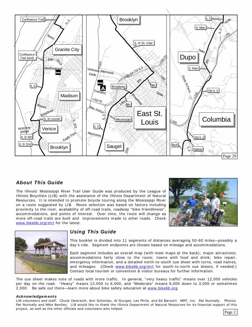
Beyond Alton, the 17-mile Confluence Trail provides more views of the Mighty Mississippi and its confluence with the Missouri. After trail’s end, the route mostly follows Illinois Route 3 through the industrial towns of the Metro East area. Expect trucks and rough urban areas.
Food: Alton (CS), Wood River (CS), Granite City (CS), East St. Louis (CS), Sauget (CS), Cahokia (CS), Dupo (CS)
Bicycle Repair: Edwardsville: The Cyclery, 244 S. Buchanan, 618-692-0070 Pontoon Beach: Breese Bikes, 3809 Pontoon Rd, 618-797-0434 Fairview Heights: Touring Cyclist, 101 Lanaghan Dr, 618-398-6800
Emergency Information: Hospital: Dial 911 State Police: Dial 911
Cue Sheet - Alton to Dupo, 34 miles Start: Alton—IL 100/ Broadway and Riverfront Dr (casino parking)
Go Dir On Miles Total R S/E Riverfront Dr/ local trails to MCT Confluence Trail (Follow “To: MCT Confluence Trail” signs).............. 1.1 1.1 R SE Confluence Trail to Lock & Dam 26, museum............ 1.6 2.7 E/S Confluence Trail to Lewis & Clark Visitor’s Center... 7.1 9.8 S Confluence Trail to Chain of Rocks Bridge road......... 3.3 13.1 S Confluence Tr to IL 3/ 20th St - Granite City - F&D..5.1 18.2 S IL 3 to McKinley Bridge road - heavy traffic.............. 2.5 20.7 L E IL 3 - Venice................................................................ 0.3 21.0 R SE IL 3/ Lincoln Ave......................................................... 0.1 21.1 R S IL 3/ 4th St - heavy traffic............................................ 0.7 21.8 R S/SE IL 3/ 2nd St/ St. Clair Ave - East St. Louis - F&D Caution: heavy to very heavy traffic........................... 2.4 24.2 SE St. Clair Ave (across interstate)................................... 0.3 24.5 R SW 9th St (one-way)........................................................... 1.0 25.5 R NW Broadway..................................................................... 0.1 25.6 L SW 8th St/ Mississippi Ave................................................ 1.3 26.9 L S IL 3 - Cahokia - F&D Take care: heavy traffic but some paved shoulders.... 2.6 29.5 S IL 3............................................................................... 2.1 31.6 R SW Stolle Rd/ Main St - Dupo - F&D - moderate traffic... 2.8 34.4
Main St and I-255/ US 50 - Dupo
Page 18
Page 13
P28
Camping: Pleasant Hill: Great River Road Campground, Co. 1, Box 198, 217-734-9006 Kampsville: City Hall Campground Beechville: Cedar Hill Restaurant Marina and RV Parking, Beech Landing Rd Grafton: Pere Marquette State Park Campground, 618-786-2331
Food: Pleasant Hill (CS), Mozier (S), Hamburg (S), Batchtown (S), Beechville (S), Brussels (CS), Cen-terville (CS), Grafton (CS), Elsah (CS), Alton (CS) Bicycle Repair: Godfrey: Wild Trak Bikes, Inc., 5745 Godfrey Rd, 618-467-2453 Alton: Eddie’s Bicycle Shop, 3320 Fernwood Ave, 618-465-6755 Emergency Information: Hospital: Dial 911 State Police: Dial 911
Cue Sheet - Pleasant Hill to Alton, 69 miles Start: Pleasant Hill—Quincy St and Main St
Go Dir On Miles Total S IL 96 - Mozier - D......................................................12.5 12.5 S IL 96 to Co 2................................................................ 0.9 13.4 S Mississippi River Rd (unmarked) - Hamburg - F&D..3.4 16.8 S Mississippi River Rd - Gilead..................................... 9.2 26.0 S Mississippi River Rd - Batchtown - F&D................... 5.2 31.2 S Mississippi River Rd - Beechville - F&D.................... 4.8 36.0 S Mississippi River Rd ................................................... 0.2 36.2 L E Schleeper Rd................................................................ 2.6 38.8 R S Illinois River Rd........................................................... 1.0 39.8 L E/SE Prosker Ln/ Main St - Brussels - F&D........................ 0.7 40.5 SE Main St/Co 1/Illinois River Rd - Centerville - F&D...1.5 42.0 R E/N Co 1/ Illinois River Rd to Brussels Ferry..................... 6.4 48.4 * Pere Marquette St Park lodge - 3 miles W on IL 100, Vadalabene Trail R E IL 100 - moderate traffic.............................................. 1.0 49.4 L N Graham Hollow Rd...................................................... 0.0 49.4 R E Sam Vadalabene Bikeway - Grafton - F&D............... 3.0 52.4 SE Sam Vadalabene Bikeway/ IL 100 - Elsah ................. 4.5 56.9 SE Sam Vadalabene Bikeway/ IL 100 Piasa Bird Painting parking.........................................10.1 68.0 SE IL 100 - Alton - F&D................................................... 1.5 69.5
IL 100/ Broadway and Riverfront Dr (casino parking) - Alton
#S
#S
Pleasant Hill
Hamburg
Batchtown
Grafton
ElsahGodfrey
Mozier
Beechville
Brussels
Centerville
Kampsville
Hardin
Alton
Major Attractions: Kampsville - The Center for American Archeology Brussels - Apples in fall, peaches in spring, Pere Marquette Cross - IL 100 (across from Brussels Ferry) Grafton - Confluence of Illinois and Mississippi, Pere Marquette State Park Alton - Alton Museum of History and Art; Confederate Cemetery; Confederate Prison; Lovejoy Monument, Alton Cemetery; Piasa Bird, On River Bluff, 1 Mile West of Alton, Visitors Center on IL 100; Robert Wadlow Monument; Lincoln-Douglas, Broadway and Landmarks; National Great Rivers Museum at Lock and Dam 26
Accommodations fairly close to the trail: Lodging: Pleasant Hill: BJ's Guest Houses, 202 E. Quincy St, 217-734-2332 Hardin: Hardin Hotel, 206 N. County Rd, 618-576-9003 Calhoun Co Line/ Nebo: Harpoles Heartland Lodge (3.5 mi N of trail), RR1 Box 8A, 800-717-4868 Mozier: Baytown Guest House, 618-232-1223 Grafton: Pere Marquette State Park Lodge, 618-786-2332; Ruebel Hotel, 217 E. Main, 618-786-2315 Alton: Comfort Inn, 11 Crossroads Ct, 618-465-9999; Days Inn, 1900 Homer Adams Pkwy, 618-463-0800; Beall Mansion B & B, 407 E. 12th St, 618-474-9100, 800-990-2325; Holiday Inn, 3800 Homer Adams Pkwy, 618-462-1220; Jackson House B & B, 1821 Seminary St, 618-462-1426, 800-462-1426; Super 8 Hotel, 1800 Homer Adams Pkwy, 618-465-8885; Tiffany Inn B & B, 410 E. Broadway, 618-462-4145
Illinois’ Mississippi River Trail Pleasant Hill to Alton - 69 miles
Calhoun County is a long peninsula between the Mississippi and Illinois River, offering spectacular views of the two great rivers. Cross the Illinois on the Brussels Ferry. Then, enjoy the Mississippi River bluffs as you bike the Sam Vadalabene Bikeway—a combination of off-road trails and paved shoulders along Illinois Route 100.
Page 16
Page 15
P28


![Park Map of Natchez Trace Parkway National Scenic Trail [Mississippi, Alabama, and Tennessee]](https://img.pdfslide.us/doc/110x75/577ce6f11a28abf10393ff30/park-map-of-natchez-trace-parkway-national-scenic-trail-mississippi-alabama.jpg)