Embed Size (px)
Citation preview
Appendix E
Final Integrated
GRR and SEIS
April 2018
APPENDIX E
Scoping Report
Mississippi River Ship Channel Gulf to Baton Rouge, LA Integrated General Reevaluation Report And Supplemental Environmental Impact Statement
US Army Corps of Engineers New Orleans District
National Environmental Policy Act
SCOPING REPORT
Mississippi River Ship Channel, Gulf to Baton Rouge, Louisiana, General Reevaluation Study and Supplemental Environmental Impact Statement
July 2015
Mississippi River Ship Channel, Gulf to Baton Rouge, Louisiana – Scoping Report Page 2
TABLE OF CONTENTS
1.0 INTRODUCTION.................................................................................................3 2.0 STUDY BACKGROUND AND AUTHORITY..................................................3 3.0 STUDY PURPOSE AND NEED.........................................................................5 4.0 STUDY AREA.....................................................................................................5 5.0 PROJECT GOALS/OBJECTIVES.......................................................................5 6.0 SCOPING MEETING..........................................................................................6 7.0 SCOPING COMMENTS.....................................................................................7 8.0 SUMMARY OF SCOPING COMMENTS.......................................................34 9.0 CONCLUSIONS................................................................................................34
APPENDIX A – SCOPING MEETING ATTENDANCE SHEETS APPENDIX B – SCOPING COMMENT LETTERS, EMAILS, POSTCARDS APPENDIX C – PUBLIC SCOPING MEETING TRANSCRIPTS
Mississippi River Ship Channel, Gulf to Baton Rouge, Louisiana – Scoping Report Page 3
National Environmental Policy Act
SCOPING REPORT
Mississippi River Ship Channel, Gulf to Baton Rouge, Louisiana Project General Reevaluation Report and Supplemental Environmental Impact Statement
July 2015
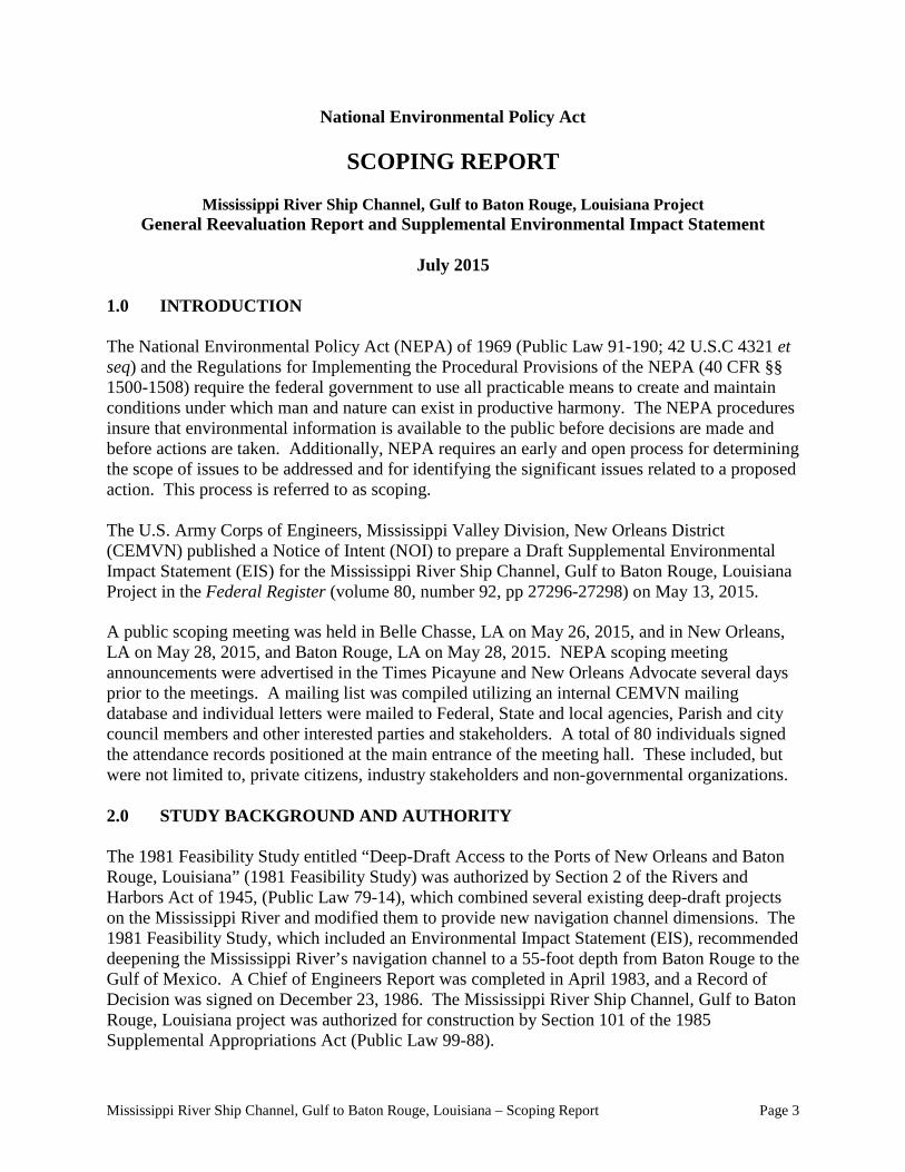
1.0 INTRODUCTION
The National Environmental Policy Act (NEPA) of 1969 (Public Law 91-190; 42 U.S.C 4321 et seq) and the Regulations for Implementing the Procedural Provisions of the NEPA (40 CFR §§ 1500-1508) require the federal government to use all practicable means to create and maintain conditions under which man and nature can exist in productive harmony. The NEPA procedures insure that environmental information is available to the public before decisions are made and before actions are taken. Additionally, NEPA requires an early and open process for determining the scope of issues to be addressed and for identifying the significant issues related to a proposed action. This process is referred to as scoping.
The U.S. Army Corps of Engineers, Mississippi Valley Division, New Orleans District (CEMVN) published a Notice of Intent (NOI) to prepare a Draft Supplemental Environmental Impact Statement (EIS) for the Mississippi River Ship Channel, Gulf to Baton Rouge, Louisiana Project in the Federal Register (volume 80, number 92, pp 27296-27298) on May 13, 2015.
A public scoping meeting was held in Belle Chasse, LA on May 26, 2015, and in New Orleans, LA on May 28, 2015, and Baton Rouge, LA on May 28, 2015. NEPA scoping meeting announcements were advertised in the Times Picayune and New Orleans Advocate several days prior to the meetings. A mailing list was compiled utilizing an internal CEMVN mailing database and individual letters were mailed to Federal, State and local agencies, Parish and city council members and other interested parties and stakeholders. A total of 80 individuals signed the attendance records positioned at the main entrance of the meeting hall. These included, but were not limited to, private citizens, industry stakeholders and non-governmental organizations.
2.0 STUDY BACKGROUND AND AUTHORITY
The 1981 Feasibility Study entitled “Deep-Draft Access to the Ports of New Orleans and Baton Rouge, Louisiana” (1981 Feasibility Study) was authorized by Section 2 of the Rivers and Harbors Act of 1945, (Public Law 79-14), which combined several existing deep-draft projects on the Mississippi River and modified them to provide new navigation channel dimensions. The 1981 Feasibility Study, which included an Environmental Impact Statement (EIS), recommended deepening the Mississippi River’s navigation channel to a 55-foot depth from Baton Rouge to the Gulf of Mexico. A Chief of Engineers Report was completed in April 1983, and a Record of Decision was signed on December 23, 1986. The Mississippi River Ship Channel, Gulf to Baton Rouge, Louisiana project was authorized for construction by Section 101 of the 1985 Supplemental Appropriations Act (Public Law 99-88).
Mississippi River Ship Channel, Gulf to Baton Rouge, Louisiana – Scoping Report Page 4
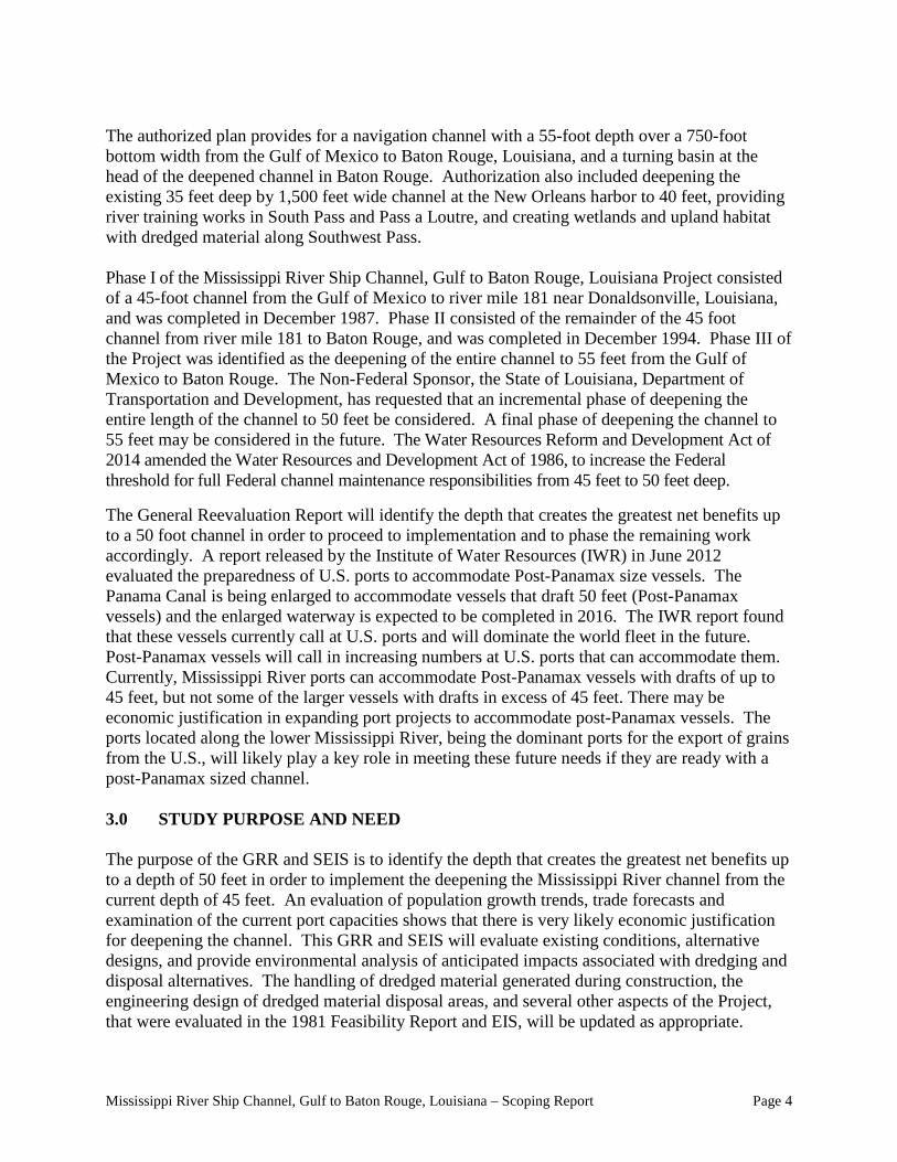
The authorized plan provides for a navigation channel with a 55-foot depth over a 750-foot bottom width from the Gulf of Mexico to Baton Rouge, Louisiana, and a turning basin at the head of the deepened channel in Baton Rouge. Authorization also included deepening the existing 35 feet deep by 1,500 feet wide channel at the New Orleans harbor to 40 feet, providing river training works in South Pass and Pass a Loutre, and creating wetlands and upland habitat with dredged material along Southwest Pass. Phase I of the Mississippi River Ship Channel, Gulf to Baton Rouge, Louisiana Project consisted of a 45-foot channel from the Gulf of Mexico to river mile 181 near Donaldsonville, Louisiana, and was completed in December 1987. Phase II consisted of the remainder of the 45 foot channel from river mile 181 to Baton Rouge, and was completed in December 1994. Phase III of the Project was identified as the deepening of the entire channel to 55 feet from the Gulf of Mexico to Baton Rouge. The Non-Federal Sponsor, the State of Louisiana, Department of Transportation and Development, has requested that an incremental phase of deepening the entire length of the channel to 50 feet be considered. A final phase of deepening the channel to 55 feet may be considered in the future. The Water Resources Reform and Development Act of 2014 amended the Water Resources and Development Act of 1986, to increase the Federal threshold for full Federal channel maintenance responsibilities from 45 feet to 50 feet deep.
The General Reevaluation Report will identify the depth that creates the greatest net benefits up to a 50 foot channel in order to proceed to implementation and to phase the remaining work accordingly. A report released by the Institute of Water Resources (IWR) in June 2012 evaluated the preparedness of U.S. ports to accommodate Post-Panamax size vessels. The Panama Canal is being enlarged to accommodate vessels that draft 50 feet (Post-Panamax vessels) and the enlarged waterway is expected to be completed in 2016. The IWR report found that these vessels currently call at U.S. ports and will dominate the world fleet in the future. Post-Panamax vessels will call in increasing numbers at U.S. ports that can accommodate them. Currently, Mississippi River ports can accommodate Post-Panamax vessels with drafts of up to 45 feet, but not some of the larger vessels with drafts in excess of 45 feet. There may be economic justification in expanding port projects to accommodate post-Panamax vessels. The ports located along the lower Mississippi River, being the dominant ports for the export of grains from the U.S., will likely play a key role in meeting these future needs if they are ready with a post-Panamax sized channel. 3.0 STUDY PURPOSE AND NEED The purpose of the GRR and SEIS is to identify the depth that creates the greatest net benefits up to a depth of 50 feet in order to implement the deepening the Mississippi River channel from the current depth of 45 feet. An evaluation of population growth trends, trade forecasts and examination of the current port capacities shows that there is very likely economic justification for deepening the channel. This GRR and SEIS will evaluate existing conditions, alternative designs, and provide environmental analysis of anticipated impacts associated with dredging and disposal alternatives. The handling of dredged material generated during construction, the engineering design of dredged material disposal areas, and several other aspects of the Project, that were evaluated in the 1981 Feasibility Report and EIS, will be updated as appropriate.
Mississippi River Ship Channel, Gulf to Baton Rouge, Louisiana – Scoping Report Page 5
4.0 STUDY AREA The study area is located in the southeastern portion of Louisiana and consists of the Mississippi River below Baton Rouge and its major outlet to the Gulf of Mexico, Southwest Pass. The area includes the 45 foot channel of the Mississippi River which services 4 of the top 15 ports in the United States including the largest port, the Port of South Louisiana. The Mississippi River, Gulf of Mexico to Baton Rouge Louisiana project authorized the construction of the channel to a depth of 55 feet. The project has been constructed and maintained to dimensions of 45' x 750' from New Orleans to Mile 18 BHP and 45' x 600' from Mile 18 BHP to Gulf of Mexico allowing for transfer of over 400,000,000 tons of cargo each year. 5.0 PROJECT GOALS & OBJECTIVES The initial planning goal is to confirm that the authorized project is economically justified to move forward to construction. The ultimate goal of the project is to improve deep draft navigation on the MRSC to the authorized 50-55 feet in two phases (Phases III and IV). Phase III would increase the depth from 45ft. to 50ft. from the Gulf of Mexico to Baton Rouge. The final Phase IV would be pursued at a later date and would deepen the channel from a depth of 50 ft to 55 ft.
Planning Constraints - Avoid or minimize potential impacts on existing ecological resources in the lower delta. - Avoid impacts or minimize potential impacts to existing channel training works in the lower MS River Delta, particularly in South West Pass. - Avoid impacts or minimize potential impacts to the riverine and hurricane risk reduction system adjacent to the Mississippi River Ship Channel
Planning Objectives The plan formulation will based on the following project objectives, while keeping the constraints in mind: - Reduce transportation costs caused by vessel light loading, tidal/river stage delays, or other transportation costs for commercial deep draft navigation relating to insufficient depths in the Mississippi River Ship Channel, from the entrance channel in the Gulf of Mexico (Mile 22 BHP) to Baton Rouge (Mile 232.4), beginning in 2020. * Measuring: Transportation cost savings * Data Needed: Current and Future Shipping Fleet data - Preserve, enhance, and restore ecological resources in the lower delta adjacent to the Mississippi River Ship Channel. * Measuring: Acres of Marsh Created from Beneficial Use, AAHUs * Data Needs: Beneficial use material available by year, bathymetry data, and land loss rates - Reduce navigation concerns and improve vessel safety relating to insufficient width, in the Mississippi River Ship Channel Crossings (Mile 181 to Mile 232.4) beginning in 2020. * Measuring: TBD * Data Needed: TBD
Mississippi River Ship Channel, Gulf to Baton Rouge, Louisiana – Scoping Report Page 6
- Maintain or improve operations and maintenance dredging intervals within Mississippi River Ship Channel Crossings, particularly in areas where improvements have already been investigated for the existing 45 ft depth channel, “Mississippi River Ship Channel Gulf To Baton Rouge, Louisiana, Phase II 45Foot Channel (Mile 181-232.4), Design Memorandum No. 1, Supplement No. 2, Volume I. * Measuring: Shoaling rates * Data Needed: Deposition Rates, Annual Dredging Cost, Training Dikes Construction Cost 6.0 SCOPING MEETING On May 18, 2015, a scoping meeting public notice fact sheet was mailed to approximately 407 individual mailing addresses compiled from an internal CEMVN mailing database. These individual addresses were comprised of various Federal, State and local agencies and officials, Parish and city government representatives, non-governmental organizations, and individual stakeholders and members of the public. The fact sheet provided an overview of the meeting purpose, date, address and time as well as sufficient project background, study alternatives, the purpose and need and issues/resources to be addressed. Two questions were also provided as a means of focusing the public’s concerns:
• Question #1: What are the most important issues, resources, and impacts that should be considered in the SEIS?
• Question #2: Are there any other alternatives or modifications to the tentative alternatives that should be considered in the SEIS?
In addition to the individual letters, four separate scoping meeting publications were run in three local newspapers on the following dates:
• May 19 and May 26, 2015 – Plaquemines Gazette • May 24 and May 28, 2015 – New Orleans Advocate • May 24 and May, 2015 – Baton Rouge Advocate
The May 13, 2015 Notice of Intent (volume 80, number 92, pp 27296-27298) identified the NEPA public scoping meeting dates, locations, times and meeting formats. The first scoping meeting was held on May 26, 2015 at the Belle Chasse Branch Library, in Belle Chaase, Louisiana and began at 6:00 p.m. with an Open House wherein the public was invited to visit a series of poster stations staffed by the project delivery team members and subject matter experts. The second scoping meeting was held at the New Orleans District, in New Orleans, LA and began at 8:30 a.m. The third scoping meeting was held at the Louisiana State Police Training Academy, in Baton Rouge, LA and began at 6:00 p.m. Each meeting began with Open House wherein the public was invited to visit a series of poster stations staffed by the project delivery team members and subject matter experts. The posters on display covered the following topics:
• Project Study Area Map – map depicting the region of the Mississippi River between Baton Rouge, LA and the Gulf of Mexico Louisiana showing river crossings, existing authorized depths, and areas south of Venice, LA.
Mississippi River Ship Channel, Gulf to Baton Rouge, Louisiana – Scoping Report Page 7
• Mississippi Watershed Map – map showing the United States and identifying theMississippi River Watershed as well as the major ports of the nation.
• Panama Canal Expansion diagram – comparison of the existing and future expansion ofinfrastructure in the Panama Canal.
Following the open houses, brief presentations were made to the attendees by the Senior Project Manager and Lead Planner. This presentation provided an overview of the NEPA process, discussed the historical background of Mississippi River navigation, highlighted the prior environmental studies and authorizations, and provided the context for the current study and project scoping meeting. Meeting attendees were informed that all comments and questions received during the meeting and those postmarked before June 15, 2015 would be included in the project scoping report.
After the presentations, the facilitator initiated the public comment period of the meeting. Individuals were invited to present their verbal and/or written scoping comments to be recorded without interruption. This part of the meetings continued until no further scoping comments were offered. In total, 80 individuals signed the attendance records positioned at the main entrance of the meeting halls. As the meetings concluded, all attendees were reminded to pick up postage-paid comment cards if they wished to submit additional comments at a later date.
7.0 SCOPING COMMENTS
This NEPA Scoping Report presents and summarizes the scoping comments expressed at the public scoping meetings, as well as all other scoping comments received during the scoping comment period beginning May 13, 2015, and ending June 15, 2015. This information will be considered both during the study process and in preparation of the draft Supplemental EIS. Each scoping comment was reviewed for content and categorized by where in the draft Supplemental EIS individual comments would likely be addressed. A transcript of comments made at the scoping meeting was prepared by a certified court reporter and is presented in Appendix A.
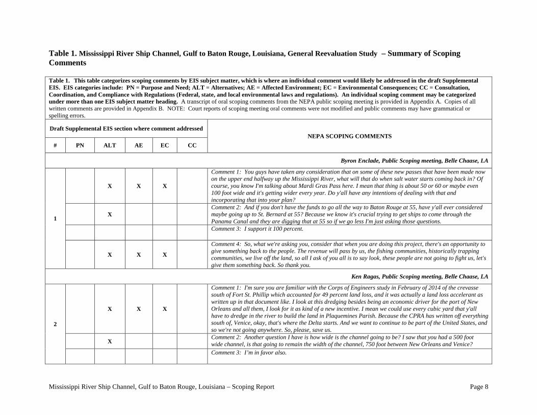
A combined total of 77 comments were recorded from scoping meeting participants and comments submitted during the scoping comment period (Table 1). Table 1 identifies the section of the draft Supplemental EIS where comments are likely to be addressed and the source of the comment. A scoping comment may be addressed in more than one section of the draft Supplemental EIS if such consideration is required to appropriately address the ramifications of the comment. Draft Supplemental EIS subject matter headings include: purpose and need for action (PN); alternatives, including the proposed action (Alt); affected environment (AE); environmental consequences (EC); and consultation and coordination (CC) with the Federal, state and other agencies . Compliance with regulations (Federal, state, and local environmental laws and regulations) is included in the latter category. Compliance with major environmental laws and regulations such as the Endangered Species Act of 1973, the Coastal Zone Management Act of 1972, and the Fish and Wildlife Coordination Act will be addressed in specific sections of the draft Supplemental EIS (especially in the Environmental Consequences section).
Mississippi River Ship Channel, Gulf to Baton Rouge, Louisiana – Scoping Report Page 8
Table 1. Mississippi River Ship Channel, Gulf to Baton Rouge, Louisiana, General Reevaluation Study – Summary of Scoping Comments
Table 1. This table categorizes scoping comments by EIS subject matter, which is where an individual comment would likely be addressed in the draft Supplemental EIS. EIS categories include: PN = Purpose and Need; ALT = Alternatives; AE = Affected Environment; EC = Environmental Consequences; CC = Consultation, Coordination, and Compliance with Regulations (Federal, state, and local environmental laws and regulations). An individual scoping comment may be categorized under more than one EIS subject matter heading. A transcript of oral scoping comments from the NEPA public scoping meeting is provided in Appendix A. Copies of all written comments are provided in Appendix B. NOTE: Court reports of scoping meeting oral comments were not modified and public comments may have grammatical or spelling errors. Draft Supplemental EIS section where comment addressed
NEPA SCOPING COMMENTS # PN ALT AE EC CC
Byron Enclade, Public Scoping meeting, Belle Chaase, LA
1
X X X
Comment 1: You guys have taken any consideration that on some of these new passes that have been made now on the upper end halfway up the Mississippi River, what will that do when salt water starts coming back in? Of course, you know I'm talking about Mardi Gras Pass here. I mean that thing is about 50 or 60 or maybe even 100 foot wide and it's getting wider every year. Do y'all have any intentions of dealing with that and incorporating that into your plan?
X Comment 2: And if you don't have the funds to go all the way to Baton Rouge at 55, have y'all ever considered maybe going up to St. Bernard at 55? Because we know it's crucial trying to get ships to come through the Panama Canal and they are digging that at 55 so if we go less I'm just asking those questions.
Comment 3: I support it 100 percent.
X X X
Comment 4: So, what we're asking you, consider that when you are doing this project, there's an opportunity to give something back to the people. The revenue will pass by us, the fishing communities, historically trapping communities, we live off the land, so all I ask of you all is to say look, these people are not going to fight us, let's give them something back. So thank you.
Ken Ragas, Public Scoping meeting, Belle Chaase, LA
2
X X X
Comment 1: I'm sure you are familiar with the Corps of Engineers study in February of 2014 of the crevasse south of Fort St. Phillip which accounted for 49 percent land loss, and it was actually a land loss accelerant as written up in that document like. I look at this dredging besides being an economic driver for the port of New Orleans and all them, I look for it as kind of a new incentive. I mean we could use every cubic yard that y'all have to dredge in the river to build the land in Plaquemines Parish. Because the CPRA has written off everything south of, Venice, okay, that's where the Delta starts. And we want to continue to be part of the United States, and so we're not going anywhere. So, please, save us.
X Comment 2: Another question I have is how wide is the channel going to be? I saw that you had a 500 foot wide channel, is that going to remain the width of the channel, 750 foot between New Orleans and Venice?
Comment 3: I’m in favor also.
Mississippi River Ship Channel, Gulf to Baton Rouge, Louisiana – Scoping Report Page 9
Table 1. This table categorizes scoping comments by EIS subject matter, which is where an individual comment would likely be addressed in the draft Supplemental EIS. EIS categories include: PN = Purpose and Need; ALT = Alternatives; AE = Affected Environment; EC = Environmental Consequences; CC = Consultation, Coordination, and Compliance with Regulations (Federal, state, and local environmental laws and regulations). An individual scoping comment may be categorized under more than one EIS subject matter heading. A transcript of oral scoping comments from the NEPA public scoping meeting is provided in Appendix A. Copies of all written comments are provided in Appendix B. NOTE: Court reports of scoping meeting oral comments were not modified and public comments may have grammatical or spelling errors. Draft Supplemental EIS section where comment addressed
NEPA SCOPING COMMENTS # PN ALT AE EC CC
Ken Ragas, Public Scoping meeting, Belle Chaase, LA
2 X
Comment 4: What would be the proper method of communicating to y'all on the, say, building of a ridge on south of Ostrica, I mean would that be through the Parish would be the correct way to do that, Plaquemines Parish would say could you please use such and such borrow to do such and such a project? Ostrica wants that levee, you know, before they bulldozed the Bohemia Spillway levee the levee once ran all the way to Batiste Collette Pass and turned. Mr. Delesdernier is very familiar with that. And after Hurricane Camille the levee was not maintained by the Corps of Engineers anymore so it's --they must have 30 cuts in it right now. Try to make it wider so we can get something.
Clay Guidry, Public Scoping meeting, Belle Chaase, LA.
3
X X X Comment 1: Do you have any estimate of dredge material if you are going to remove or you haven't got that far yet?
X Comment 2: Do you have any plans to cooperate with the Louisiana CPRA and some of their projects?
X Comment 3: And that's the only way we are ever going to rebuild some of our wetlands, with dredge material out of the Mississippi River.
X X X X
Comment 4: I would also like to make a comment about what Mr. Ken was talking about, when you are talking about salt water intrusion up the river you have got so many cuts and breaks in the river right now that I don't know how, if you widen it and deepen it, and you have more volume you are going to have more problems than just water supply in Belle Chasse if you don't close up some of these Mardi Gras Pass, Port St. Phillip, that's all consideration that you really need to look at because when we have low river events we have to be concerned about those water intakes. You might run all the way up to New Orleans. I used to work with my friend Bryon back at the Alliance Refinery and I seen them have to put in a desalination plant so that they could purify the water so it wouldn't contaminate their systems so that's pretty high up. And If you have more volume with deeper and wider you are going to have that problem.
X Comment 5: I worked with the CPRA and worked with the user groups, shrimp guys and oyster guys in doing some of these projects. And I'll push on my end and have the pipe ready for you so you can hook into it. Thank you.
Comment 6: I am in favor of it most definitely.
Mississippi River Ship Channel, Gulf to Baton Rouge, Louisiana – Scoping Report Page 10
Table 1. This table categorizes scoping comments by EIS subject matter, which is where an individual comment would likely be addressed in the draft Supplemental EIS. EIS categories include: PN = Purpose and Need; ALT = Alternatives; AE = Affected Environment; EC = Environmental Consequences; CC = Consultation, Coordination, and Compliance with Regulations (Federal, state, and local environmental laws and regulations). An individual scoping comment may be categorized under more than one EIS subject matter heading. A transcript of oral scoping comments from the NEPA public scoping meeting is provided in Appendix A. Copies of all written comments are provided in Appendix B. NOTE: Court reports of scoping meeting oral comments were not modified and public comments may have grammatical or spelling errors. Draft Supplemental EIS section where comment addressed
NEPA SCOPING COMMENTS # PN ALT AE EC CC
Clay Guidry, Public Scoping meeting, Belle Chaase, LA.
3
X X
Comment 7: Are you guys cooperating -- right now CRPA is conducting some studies, river studies and trying to build very large scale versions of 65,000 CFS mid Barataria River Road and that's going to have some effect on the flow of the river, shoaling, are you working with those guys to kind of incorporate what they want to do into what you want to do? Because I think the numbers they are using are probably not considering 54 or 55 feet that you have got issue for.
X X X
Comment 8: A lot of that money is not going to Plaquemines Parish, probably the largest percentage out of state, so what I would suggest is that you work with the Corps and set up your projects. I don't think the State can stop you from doing projects for Plaquemines Parish. And they are going to determine what cost it's going to be to get the sediment to wherever, and they may say well, we'll need this much money for this project. You take it from there, it's going to be less of a cost if you hire the dredging than you doing it yourself. That's what I try to get it across to CPRA, we should be marrying up, for want of a better word, with the Corps, and when they do their project we can have a project ready and pipeline waiting there. And if it takes a booster pump we should be doing the same thing, we should have those pipelines in place already and we don't. Instead we're spending 100 million dollars on consulting fees to see if we can build diversions.
Mark Delesdernier, Public Scoping meeting, Belle Chaase, LA.
4
Comment 1: I fully support your project for 50 foot
X Comment 2: Now I would say since '48 we have had ships that can come in here and load way more than 45 feet but we restricted, and if we don't do something about this we're going to lose this business to Houston, we're going to lose it to Charleston, Mobile, the Texas Ports. We're at the bottom of the funnel for mid America.
X Comment 3: It's going to be important because if you are in the marine industry and you go to Houston they are already saying, God if we had the Mississippi River what we could do. And that's true and we really need to not sit on our hands, we really need to move on this project.
X Comment 4: So it just goes to tell you that diversions are not always are going to help the situation. But what we really need is the money to be able to take that dredge material and pump it into the swamps and rebuild our land, and that's what's going to be important with this project.
X Comment 5: One of the things you are going to have to consider is that the Corps is going to have to have the capacity with dredging to maintain this channel because you can't depend on private industry. Thank you.
Mississippi River Ship Channel, Gulf to Baton Rouge, Louisiana – Scoping Report Page 11
Table 1. This table categorizes scoping comments by EIS subject matter, which is where an individual comment would likely be addressed in the draft Supplemental EIS. EIS categories include: PN = Purpose and Need; ALT = Alternatives; AE = Affected Environment; EC = Environmental Consequences; CC = Consultation, Coordination, and Compliance with Regulations (Federal, state, and local environmental laws and regulations). An individual scoping comment may be categorized under more than one EIS subject matter heading. A transcript of oral scoping comments from the NEPA public scoping meeting is provided in Appendix A. Copies of all written comments are provided in Appendix B. NOTE: Court reports of scoping meeting oral comments were not modified and public comments may have grammatical or spelling errors. Draft Supplemental EIS section where comment addressed
NEPA SCOPING COMMENTS # PN ALT AE EC CC
Charlie Bird, Public Scoping meeting, Belle Chaase, LA.
5 X X X
Comment 1: My comment is who actually has the final authority to determine where that dredge material goes as far as the Corps? So if it's dredged in Plaquemines Parish technically that should go back in Plaquemines Parish and not another state or another Parish hopefully. It's not going to be cost effective to put it not close to where it's been dredged.
Sean Duffy, Public Scoping meeting, Belle Chaase, LA.
6
X X X
Comment 1: Some of the things that I think are important enough to be on the record to say is since 2009 not only have we been doing the hopper dredges but in 2009 we started using cutter head dredges in Southwest Pass which hadn't been done in decades to the tune of about 4000 acres being created just through, in my mind, navigation partnering with the Corps to look at those kind of efforts. But I think one of the things that's important to remember here is dredging will be below Venice. So the areas for beneficial use to look at maximizing would be below Venice also.
Comment 2: But I mean we face things that make, in my mind, no sense, elevation limits, and we have been part of successfully raising those limits in places in Southwest Pass. And if you have ever been down to Southwest Pass and seen something that you thought was too high I would love to know here it is. But I'll be glad to pick up the dredging conversation at a later time.
X X X
Comment 3: It was over 50 and last year also it was monumental for the first time in a very long time Coastal Zone Consistency was awarded to the Corps partly because of these projects where we have been going down areas that cutter heads weren't allowed to work before and using them. And what's happened is now hopper dredges are working on sandy restoration projects, so we have had to use more cutter heads which means more beneficial use. All the cutter heads are beneficial use, there's just certain places you can't work a cutter head dredge. But in 2009 the places we thought we could not work on that list has changed a lot, there's only a couple of locations where a person was very restricted. And what's happened is there's a comfort with the cutter head dredges.
X X X
Comment 4: That's the only area you have to dredge other than maybe a possible hot spot up to Bellmont Crossing which is mile 154 above header passes which is probably about ten miles above the Gramercy Bridge. So if you dredge from Venice on down the next place other than the New Orleans Harbor alongside the docks, if you have to dredge, the only place you have to dredge the channel once Venice is open is Bellmont Crossing, it's the first one that would have to be dredged.
Mississippi River Ship Channel, Gulf to Baton Rouge, Louisiana – Scoping Report Page 12
Table 1. This table categorizes scoping comments by EIS subject matter, which is where an individual comment would likely be addressed in the draft Supplemental EIS. EIS categories include: PN = Purpose and Need; ALT = Alternatives; AE = Affected Environment; EC = Environmental Consequences; CC = Consultation, Coordination, and Compliance with Regulations (Federal, state, and local environmental laws and regulations). An individual scoping comment may be categorized under more than one EIS subject matter heading. A transcript of oral scoping comments from the NEPA public scoping meeting is provided in Appendix A. Copies of all written comments are provided in Appendix B. NOTE: Court reports of scoping meeting oral comments were not modified and public comments may have grammatical or spelling errors. Draft Supplemental EIS section where comment addressed
NEPA SCOPING COMMENTS # PN ALT AE EC CC
Benny Rousselle, Public Scoping meeting, New Orleans, LA.
7 X X X
Comment 1: My name is Benny Rousselle with Plaquemines Parish Government, and our interest is in making sure that the saltwater up the river comes to a point where we would look at that to see if there’s any impact of the increase to our coastal water supply system. I know we talked about this before the meeting, but I want to go on the record to say that we are looking forward to those results and see what impact this project will have on our water system.
X X Comment 2: How much of the river actually needs to be dredged to get to that 50 feet?
George Ricks, Public Scoping meeting, New Orleans, LA.
8 X X X
Comment 1: My name is Captain George Ricks, I am president of the State of Louisiana Coalition. My organization and I would like to go on the record by saying we support this project under conditions that this project would make beneficial usage of dredging material for coastal restoration projects. I’d also like to caution the Corps to look into the possible effects that large scale river diversions that are now proposed in the master plan may have upon itself and may compromise the depth of the river after this project is done and also increase the saltwater wedge. I’d just like the Corps to take that into consideration in the further study of this project.
Joe Cocchiara, Public Scoping meeting, New Orleans, LA.
9 X X
Comment 1: The last time this was seriously studied was three decades ago. So, I would hope that the Corps’ study this time would take that into consideration that we really need to do this in a way that does help us see far into the future -- or at least contemplate alternatives as far into the future -- as unknown as that might be. With that in mind, my first suggestion is that the study go beyond 50 feet – that it go all the way to the full authorized depth of 55 feet. I understand there is no desire at this point to go beyond the 50 feet, but I think it would be unwise to take this opportunity, when you’ve “opened up the can of worms,” you got the consultants on board, you’re studying the economics, you’re studying the technical feasibility, you’re studying all the issues such as saltwater intrusion, why not let’s look at what the implications are of going all the way to 55 feet. I personally believe you will find a 55-foot project all the way to Baton Rouge remains economically viable as it did three decades ago from a net benefit standpoint. So, I strongly suggest that you consider looking all the way to 55 feet all the way to Baton Rouge in this project.
Mississippi River Ship Channel, Gulf to Baton Rouge, Louisiana – Scoping Report Page 13
Table 1. This table categorizes scoping comments by EIS subject matter, which is where an individual comment would likely be addressed in the draft Supplemental EIS. EIS categories include: PN = Purpose and Need; ALT = Alternatives; AE = Affected Environment; EC = Environmental Consequences; CC = Consultation, Coordination, and Compliance with Regulations (Federal, state, and local environmental laws and regulations). An individual scoping comment may be categorized under more than one EIS subject matter heading. A transcript of oral scoping comments from the NEPA public scoping meeting is provided in Appendix A. Copies of all written comments are provided in Appendix B. NOTE: Court reports of scoping meeting oral comments were not modified and public comments may have grammatical or spelling errors. Draft Supplemental EIS section where comment addressed
NEPA SCOPING COMMENTS # PN ALT AE EC CC
Joe Cocchiara, Public Scoping meeting, New Orleans, LA.
9
X X
Comment 2: Secondly, I would also ask that you consider the deepening of the New Orleans Harbor to the full actualized depth of the main river shipping channel. There’s been a point of difficulty over the past several years as the port has brought in larger and deeper container ships, particularly, and we would certainly hope to be able to tap into and take benefit of the full depth that’s in the river for the harbor in New Orleans. Our containerized shipping business is our fastest growing business right now, and we would hope to be able to utilize and take advantage of the improvements of the Panama Canal and the improvements of this shipping channel.
X Comment 3: My third comment is perhaps a bit of a light comment, but I think you are wasting your time at any increments between 45 and 50. Perhaps you need to do that, but I feel truly confident that 50 is going to be the most justified depth of any depths between 45 and 50.
John Lopez, Public Scoping meeting, New Orleans, LA.
10 X X
Comment 1: There’s one comment I’d like to make. I guess it’s a question or comment that whatever comes out of it, it is consistent with the state master plan. So, my question is what assurance do we have that this process will end up as the tentatively selected plan or something be consistent with the state master plan?
Morgan Crutcher, Public Scoping meeting, New Orleans, LA.
11 X X X
Comment 1: I have a question about the Corps’ perspective on the high organization and ownership resources in the river. We’ve had past conflicts with the saltwater sill before and I can’t imagine that this will be an issue again. What is the Corps’ perspective on how those conflicts will be resolved in the future? Oh, sorry. My name is Morgan Crutcher. I am with the Coalition to Restore Coastal Louisiana.
Mississippi River Ship Channel, Gulf to Baton Rouge, Louisiana – Scoping Report Page 14
Table 1. This table categorizes scoping comments by EIS subject matter, which is where an individual comment would likely be addressed in the draft Supplemental EIS. EIS categories include: PN = Purpose and Need; ALT = Alternatives; AE = Affected Environment; EC = Environmental Consequences; CC = Consultation, Coordination, and Compliance with Regulations (Federal, state, and local environmental laws and regulations). An individual scoping comment may be categorized under more than one EIS subject matter heading. A transcript of oral scoping comments from the NEPA public scoping meeting is provided in Appendix A. Copies of all written comments are provided in Appendix B. NOTE: Court reports of scoping meeting oral comments were not modified and public comments may have grammatical or spelling errors. Draft Supplemental EIS section where comment addressed
NEPA SCOPING COMMENTS # PN ALT AE EC CC
Sean Duffy, Public Scoping meeting, New Orleans, LA.
12 X X X
Comment 1: First, on Mr. Lopez’ point about agreement with the state master plan. From a realistic standpoint, the dredging for this channel, if it is successfully funded and appropriated to move forward, is from Venice on down. I think one of the challenges with the state master plan, is there’s not a project in that area that at the lowest project on the river is about 28.5 below the diversion, so the first 50 miles of river are unaccounted for in the state master plan. There’s been a great deal of beneficial use over the last five years that it’s been getting done with cutter head dredges which led to coastal zone consistency, so I would believe there is some well-laid efforts that will help with increasing the beneficial use of dredge material which I believe is the intended goal across the board. I think that the sill discussion, there is an agreement between the state and the Corps, and I think that’s going to determine how that project is managed. So I would refer it back to that.
Mr. Hose, Public Scoping meeting, New Orleans, LA.
13 X
Comment 1: The dredging, of course, to 50 feet is totally supported. My concern is the farther we go up river with any air draft limitations created particularly during a higher river. They are going to preclude the larger ships from going up-river anyway, unless they can ballast down. So I am just requesting that the Corps look at all the air draft limitations that might present themselves.
April Newman, Public Scoping meeting, Baton Rouge, LA.
14 X
Comment 1: I'm with the Atchafalaya Basin Program. I'm curious how you will - - o r whether or not it is going to continue past the point where you're doing dredging and how it's going to affect things upstream, such as the Ole River construction? I was just wondering like how do you prevent the head coating from continuing to migrate upstream.
X X Comment 2: Will this project affect the new flow lines?
Mississippi River Ship Channel, Gulf to Baton Rouge, Louisiana – Scoping Report Page 15
Table 1. This table categorizes scoping comments by EIS subject matter, which is where an individual comment would likely be addressed in the draft Supplemental EIS. EIS categories include: PN = Purpose and Need; ALT = Alternatives; AE = Affected Environment; EC = Environmental Consequences; CC = Consultation, Coordination, and Compliance with Regulations (Federal, state, and local environmental laws and regulations). An individual scoping comment may be categorized under more than one EIS subject matter heading. A transcript of oral scoping comments from the NEPA public scoping meeting is provided in Appendix A. Copies of all written comments are provided in Appendix B. NOTE: Court reports of scoping meeting oral comments were not modified and public comments may have grammatical or spelling errors. Draft Supplemental EIS section where comment addressed
NEPA SCOPING COMMENTS # PN ALT AE EC CC
Joseph Accardo Jr, Public Scoping meeting, Baton Rouge, LA.
15
X X
Comment 1: I'm the executive director of the Ports Association of Louisiana. Our trade association represents thirty-one (31 ) port s throughout the state and in particularly, the ports along the Mississippi River , Port of South Louisiana, Port of New Orleans, Port of St. Bernard, and Port of Plaquemines. Our boards strongly support the project deepening of the Mississippi River to fifty (50) feet. In my twenty (20) years of interaction with the importers and exporters on the Mississippi River, those who export and import bulk materials, such as grain, fertilizers, oil and gas , all have said to me that a deeper channel will permit larger ships to carry cargo at more a efficient return cost and will make Americans far more – American farmers, American manufacturers – far more competitive on world market. And so therefore, we as a trade association, and I 'm sure the -- the useof the Rive r w ill - - will strongly support this project. Thank you.
X X
Comment 2: The other thing too is what we're doing is matching up the most efficient way to ship cargo and that's by barge. An d -- and I think that will affect the environment favorably because the – the leas t -- the least definitive effect on t h e environment, I believe, is to put more-- m ore cargo freight on barges, which is the most efficient way to ship it. Putting it on trucks or rail is – affects the environment far more than it would the shipping on a river.
Greg Ducote, Public Scoping meeting, Baton Rouge, LA.
16 X X Comment 1: I would like to know if there is any consideration within the study and are y' all going to look at any dredging in South Pass or -- and/or Pass a Loutre.
Bren Haase, Public Scoping meeting, Baton Rouge, LA.
17 Comment 1: I just want to say, we're, you know, excited about this effort. I think that certainly we recognize the potential economic impact a deeper channel can have on -- o n both this region of the state. But I did have a few questions.
Mississippi River Ship Channel, Gulf to Baton Rouge, Louisiana – Scoping Report Page 16
Table 1. This table categorizes scoping comments by EIS subject matter, which is where an individual comment would likely be addressed in the draft Supplemental EIS. EIS categories include: PN = Purpose and Need; ALT = Alternatives; AE = Affected Environment; EC = Environmental Consequences; CC = Consultation, Coordination, and Compliance with Regulations (Federal, state, and local environmental laws and regulations). An individual scoping comment may be categorized under more than one EIS subject matter heading. A transcript of oral scoping comments from the NEPA public scoping meeting is provided in Appendix A. Copies of all written comments are provided in Appendix B. NOTE: Court reports of scoping meeting oral comments were not modified and public comments may have grammatical or spelling errors. Draft Supplemental EIS section where comment addressed
NEPA SCOPING COMMENTS # PN ALT AE EC CC
Bren Haase, Public Scoping meeting, Baton Rouge, LA.
18
X X
Comment 1: Does the scope of this effort relate to the placement of the additional dredge material that will be generated from a deeper channel? I mean, is that -- wouldn't that be brought into consideration, because that's part of the economics?
X X X
Comment 2: One of the big concerns of our agency is just the same as the others: trying to for a sustaining coast. And so, one of the questions I guess, would be is there any - - will t here be any consideration, I guess, as far as the landscape around the navigation channel and the sustainability of it? So, you know, if it's economically justified to deepen the channel but perhaps the landscape is not there to support the channels, is that -- is any part of that going to be brought into the thinking in terms o f whether, you know, this is a – a good idea?
Comment 3: The third thing I had, I guess, was (inaudible) suite of tools that we have had available to evaluate some of these things that I would imagine and hope, I guess, that those will be use d in this effort as well. Do you know that yet? Or can you comment on that?
US Environmental Protection Agency, email dated June 03, 2015.
19 X X X
Comment 1: EPA is particularly interested in an analysis of vegetated wetlands or submerged aquatic vegetation that may be adversely or beneficially impacted. We encourage consideration of beneficial use of the dredged material by either implementing wetland fill projects, or by making dredge material available to other entities, i.e. CWPPRA, State, Third Party Mitigation Bankers for other projects. We acknowledge that beneficial use is not always practical or feasible, but we believe it should always be considered in the evaluation process.
US Fish And Wildlife Service, letter dated June 04, 2015.
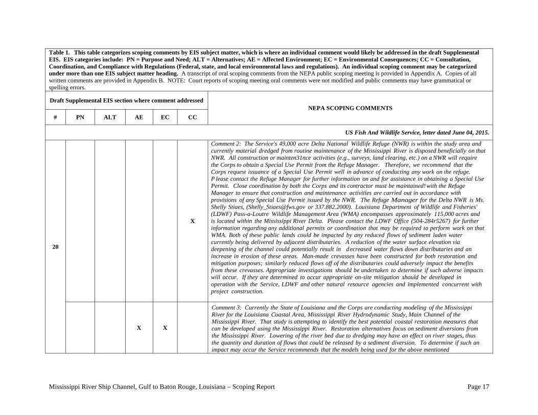
20 X
Comment 1: The most significant fish and wildlife related problem in the study area and throughout coastal Louisiana is the rapid loss of valuable wetland habitat. Currently the State of Louisiana and the Corps are conducting modeling of the Mississippi River) for the Louisiana Coastal Area, Mississippi River Hydrodynamic Study, Main Channel o f the Mississippi River. Those efforts are working to identify the best potential coastal restoration measures that can be developed.
Mississippi River Ship Channel, Gulf to Baton Rouge, Louisiana – Scoping Report Page 17
Table 1. This table categorizes scoping comments by EIS subject matter, which is where an individual comment would likely be addressed in the draft Supplemental EIS. EIS categories include: PN = Purpose and Need; ALT = Alternatives; AE = Affected Environment; EC = Environmental Consequences; CC = Consultation, Coordination, and Compliance with Regulations (Federal, state, and local environmental laws and regulations). An individual scoping comment may be categorized under more than one EIS subject matter heading. A transcript of oral scoping comments from the NEPA public scoping meeting is provided in Appendix A. Copies of all written comments are provided in Appendix B. NOTE: Court reports of scoping meeting oral comments were not modified and public comments may have grammatical or spelling errors. Draft Supplemental EIS section where comment addressed
NEPA SCOPING COMMENTS # PN ALT AE EC CC
US Fish And Wildlife Service, letter dated June 04, 2015.
20
X
Comment 2: The Service's 49,000 acre Delta National Wildlife Refuge (NWR) is within the study area and currently material dredged from routine maintenance of the Mississippi River is disposed beneficially on that NWR. All construction or mainten31nce activities (e.g., surveys, land clearing, etc.) on a NWR will require the Corps to obtain a Special Use Permit from the Refuge Manager. Therefore, we recommend that the Corps request issuance of a Special Use Permit well in advance of conducting any work on the refuge. P lease contact the Refuge Manager for further information on and for assistance in obtaining a Special Use Permit. Close coordination by both the Corps and its contractor must be maintained! with the Refuge Manager to ensure that construction and maintenance activities are carried out in accordance with provisions of any Special Use Permit issued by the NWR. The Refuge Manager for the Delta NWR is Ms. Shelly Stiaes, ([email protected] or 337.882.2000). Louisiana Department of Wildlife and Fisheries' (LDWF) Pass-a-Loutre Wildlife Management Area (WMA) encompasses approximately 115,000 acres and is located within the Mississippi River Delta. Please contact the LDWF Office (504-284r5267) for further information regarding any additional permits or coordination that may be required to perform work on that WMA. Both of these public lands could be impacted by any reduced flows of sediment laden water currently being delivered by adjacent distributaries. A reduction of the water surface elevation via deepening of the channel could potentially result in decreased water flows down distributaries and an increase in erosion of these areas. Man-made crevasses have been constructed for both restoration and mitigation purposes; similarly reduced flows off of the distributaries could adversely impact the benefits from these crevasses. Appropriate investigations should be undertaken to determine if such adverse impacts will occur. If they are determined to occur appropriate on-site mitigation should be developed in operation with the Service, LDWF and other natural resource agencies and implemented concurrent with project construction.
X X
Comment 3: Currently the State of Louisiana and the Corps are conducting modeling of the Mississippi River for the Louisiana Coastal Area, Mississippi River Hydrodynamic Study, Main Channel of the Mississippi River. That study is attempting to identify the best potential coastal restoration measures that can be developed using the Mississippi River. Restoration alternatives focus on sediment diversions from the Mississippi River. Lowering of the river bed due to dredging may have an effect on river stages, thus the quantity and duration of flows that could be released by a sediment diversion. To determine if such an impact may occur the Service recommends that the models being used for the above mentioned

Mississippi River Ship Channel, Gulf to Baton Rouge, Louisiana – Scoping Report Page 18
Table 1. This table categorizes scoping comments by EIS subject matter, which is where an individual comment would likely be addressed in the draft Supplemental EIS. EIS categories include: PN = Purpose and Need; ALT = Alternatives; AE = Affected Environment; EC = Environmental Consequences; CC = Consultation, Coordination, and Compliance with Regulations (Federal, state, and local environmental laws and regulations). An individual scoping comment may be categorized under more than one EIS subject matter heading. A transcript of oral scoping comments from the NEPA public scoping meeting is provided in Appendix A. Copies of all written comments are provided in Appendix B. NOTE: Court reports of scoping meeting oral comments were not modified and public comments may have grammatical or spelling errors. Draft Supplemental EIS section where comment addressed
NEPA SCOPING COMMENTS # PN ALT AE EC CC
US Fish And Wildlife Service, letter dated June 04, 2015.
20
X X
hydrodynamic study be employed, as appropriate, to determine if such potential impacts are likely and their impact on those coastal restoration efforts quantified. Impacts to existing freshwater diversions and siphons should also be ascertained The Coastal Wetlands Planning, Protection and Restoration program, (CWPPRA) has funded restoration projects that involve dredging sediments from shoals in the river to restore eroded coastal marshes. If changes in the river flow patterns fr9m the proposed deepening decrease sedimentation on those shoals there could be a negative impact to such restoration efforts. Therefore, the Service recommends investigations be undertaken to determine and address these potential impacts.
X X
Comment 4: The Service recommends that to the extent feasible all dredged material should be used beneficially to restore coastal habitats that are in decline. The Service continues to urge the Corps to reduce or avoid the use of the Hopper Dredge disposal Area (HDDA), near the head of Pass-a-Loutre and South Pass in order to avoid or lessen the impacts to fish and wildlife habitat in Delta NWR and Pass-a-Loutre WMA. The Service commends the Corps for their habitat creation in the Mississippi River Delta using material excavated from the HDDA but urges the Corps to directly place dredged material at beneficial us sites. We also continue to recommend, when practicable, the expanded use of cutterhead dredges which have been used successfully in Southwest Pass to create wetland habitat along the channel. If hopper dredges are used for construction the Service r ecommends the Corps utilize the hopper dredge pump out technique to maximize beneficial use. / With the hopper dredge pump out technique an additional hopper dredge would be used so that while one is dredging the other could have dredged material pumped from the hopper for beneficial use. Moreover, material removed from the channel by hopper dredge and placed! in a designated beneficial use site would reduce the amount of material placed in the "Above Head of Passes" HDDA or the designated ocean disposal site as requested in the previous paragraph. To help plan the beneficial use of dredged material from construction and/or maintenance the Service recommends that the Corps determine dredging future locations and quantities of dredged material and provide this information to the resource agencies as early as possible.
Mississippi River Ship Channel, Gulf to Baton Rouge, Louisiana – Scoping Report Page 19
Table 1. This table categorizes scoping comments by EIS subject matter, which is where an individual comment would likely be addressed in the draft Supplemental EIS. EIS categories include: PN = Purpose and Need; ALT = Alternatives; AE = Affected Environment; EC = Environmental Consequences; CC = Consultation, Coordination, and Compliance with Regulations (Federal, state, and local environmental laws and regulations). An individual scoping comment may be categorized under more than one EIS subject matter heading. A transcript of oral scoping comments from the NEPA public scoping meeting is provided in Appendix A. Copies of all written comments are provided in Appendix B. NOTE: Court reports of scoping meeting oral comments were not modified and public comments may have grammatical or spelling errors. Draft Supplemental EIS section where comment addressed
NEPA SCOPING COMMENTS # PN ALT AE EC CC
US Fish And Wildlife Service, letter dated June 04, 2015.
20
X X
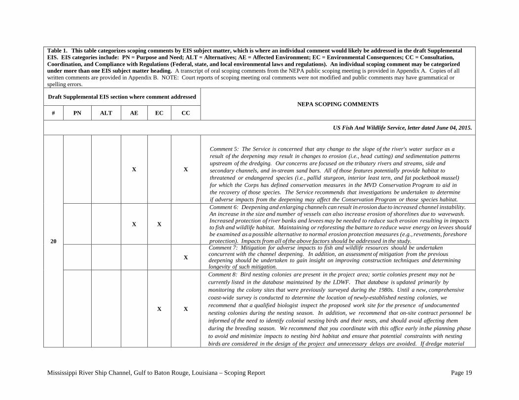
Comment 5: The Service is concerned that any change to the slope of the river's water surface as a result of the deepening may result in changes to erosion (i.e., head cutting) and sedimentation patterns upstream of the dredging. Our concerns are focused on the tributary rivers and streams, side and secondary channels, and in-stream sand bars. All of those features potentially provide habitat to threatened or endangered species (i.e., pallid sturgeon, interior least tern, and fat pocketbook mussel) for which the Corps has defined conservation measures in the MVD Conservation Program to aid in the recovery of those species. The Service recommends that investigations be undertaken to determine if adverse impacts from the deepening may affect the Conservation Program or those species habitat.
X X
Comment 6: Deepening and enlarging channels can result in erosion due to increased channel instability. An increase in the size and number of vessels can also increase erosion of shorelines due to wavewash. Increased protection of river banks and levees may be needed to reduce such erosion resulting in impacts to fish and wildlife habitat. Maintaining or reforesting the batture to reduce wave energy on levees should be examined as a possible alternative to normal erosion protection measures (e.g., revetments, foreshore protection). Impacts from all of the above factors should be addressed in the study.
X
Comment 7: Mitigation for adverse impacts to fish and wildlife resources should be undertaken concurrent with the channel deepening. In addition, an assessment of mitigation from the previous deepening should be undertaken to gain insight on improving construction techniques and determining longevity of such mitigation.
X X
Comment 8: Bird nesting colonies are present in the project area; sortie colonies present may not be currently listed in the database maintained by the LDWF. That database is updated primarily by monitoring the colony sites that were previously surveyed during the 1980s. Until a new, comprehensive coast-wide survey is conducted to determine the location of newly-established nesting colonies, we recommend that a qualified biologist inspect the proposed work site for the presence of undocumented nesting colonies during the nesting season. In addition, we recommend that on-site contract personnel be informed of the need to identify colonial nesting birds and their nests, and should avoid affecting them during the breeding season. We recommend that you coordinate with this office early in the planning phase to avoid and minimize impacts to nesting bird habitat and ensure that potential constraints with nesting birds are considered in the design of the project and unnecessary delays are avoided. If dredge material
Mississippi River Ship Channel, Gulf to Baton Rouge, Louisiana – Scoping Report Page 20
Table 1. This table categorizes scoping comments by EIS subject matter, which is where an individual comment would likely be addressed in the draft Supplemental EIS. EIS categories include: PN = Purpose and Need; ALT = Alternatives; AE = Affected Environment; EC = Environmental Consequences; CC = Consultation, Coordination, and Compliance with Regulations (federal, state, and local environmental laws and regulations). An individual scoping comment may be categorized under more than one EIS subject matter heading. A transcript of oral scoping comments from the NEPA public scoping meeting is provided in Appendix A. Copies of all written comments are provided in Appendix B. NOTE: Court reports of scoping meeting oral comments were not modified and public comments may have grammatical or spelling errors. Draft Supplemental EIS section where comment addressed
NEPA SCOPING COMMENTS # PN ALT AE EC CC
US Fish And Wildlife Service, letter dated June 04, 2015.
20
X X
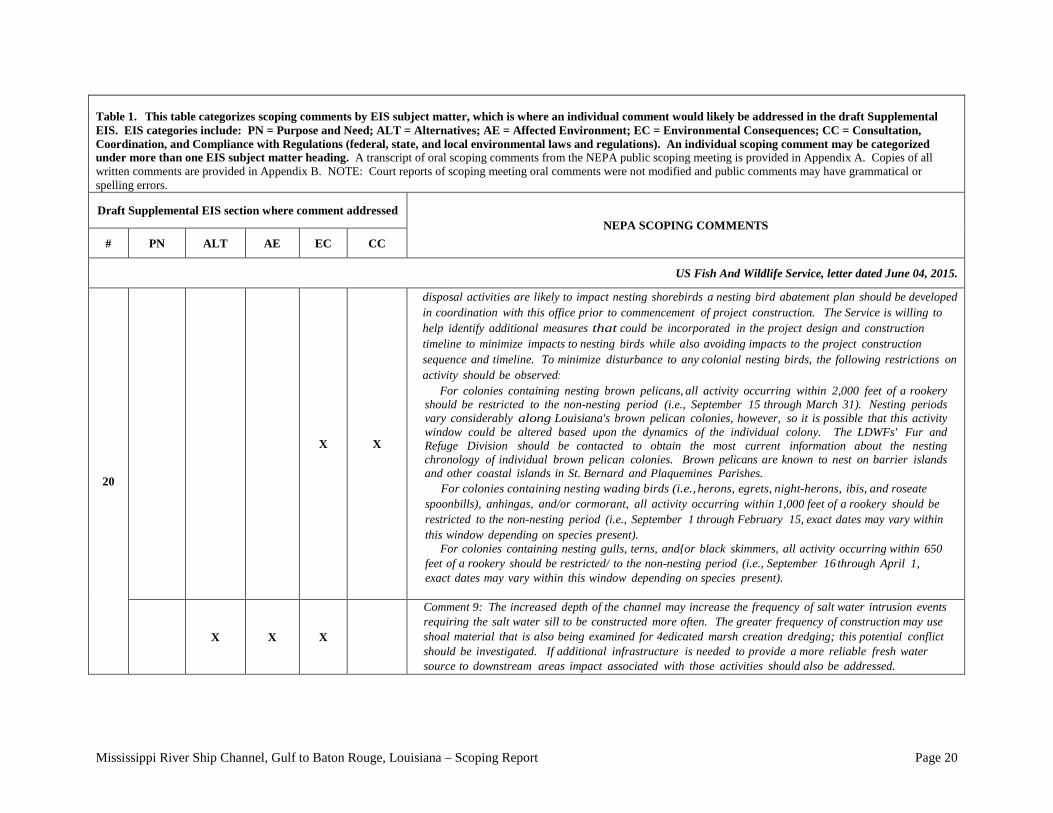
disposal activities are likely to impact nesting shorebirds a nesting bird abatement plan should be developed in coordination with this office prior to commencement of project construction. The Service is willing to help identify additional measures that could be incorporated in the project design and construction timeline to minimize impacts to nesting birds while also avoiding impacts to the project construction sequence and timeline. To minimize disturbance to any colonial nesting birds, the following restrictions on activity should be observed: For colonies containing nesting brown pelicans, all activity occurring within 2,000 feet of a rookery should be restricted to the non-nesting period (i.e., September 15 through March 31). Nesting periods vary considerably along Louisiana's brown pelican colonies, however, so it is possible that this activity window could be altered based upon the dynamics of the individual colony. The LDWFs' Fur and Refuge Division should be contacted to obtain the most current information about the nesting chronology of individual brown pelican colonies. Brown pelicans are known to nest on barrier islands and other coastal islands in St. Bernard and Plaquemines Parishes. For colonies containing nesting wading birds (i.e., herons, egrets, night-herons, ibis, and roseate spoonbills), anhingas, and/or cormorant, all activity occurring within 1,000 feet of a rookery should be restricted to the non-nesting period (i.e., September 1 through February 15, exact dates may vary within this window depending on species present). For colonies containing nesting gulls, terns, and{or black skimmers, all activity occurring within 650 feet of a rookery should be restricted/ to the non-nesting period (i.e., September 16 through April 1, exact dates may vary within this window depending on species present).
X X X
Comment 9: The increased depth of the channel may increase the frequency of salt water intrusion events requiring the salt water sill to be constructed more often. The greater frequency of construction may use shoal material that is also being examined for 4edicated marsh creation dredging; this potential conflict should be investigated. If additional infrastructure is needed to provide a more reliable fresh water source to downstream areas impact associated with those activities should also be addressed.
Mississippi River Ship Channel, Gulf to Baton Rouge, Louisiana – Scoping Report Page 21
Table 1. This table categorizes scoping comments by EIS subject matter, which is where an individual comment would likely be addressed in the draft Supplemental EIS. EIS categories include: PN = Purpose and Need; ALT = Alternatives; AE = Affected Environment; EC = Environmental Consequences; CC = Consultation, Coordination, and Compliance with Regulations (Federal, State, and local environmental laws and regulations). An individual scoping comment may be categorized under more than one EIS subject matter heading. A transcript of oral scoping comments from the NEPA public scoping meeting is provided in Appendix A. Copies of all written comments are provided in Appendix B. NOTE: Court reports of scoping meeting oral comments were not modified and public comments may have grammatical or spelling errors.
Draft Supplemental EIS section where comment addressed
NEPA SCOPING COMMENTS # PN ALT AE EC CC
US Fish And Wildlife Service, letter dated June 04, 2015
20 X X X X
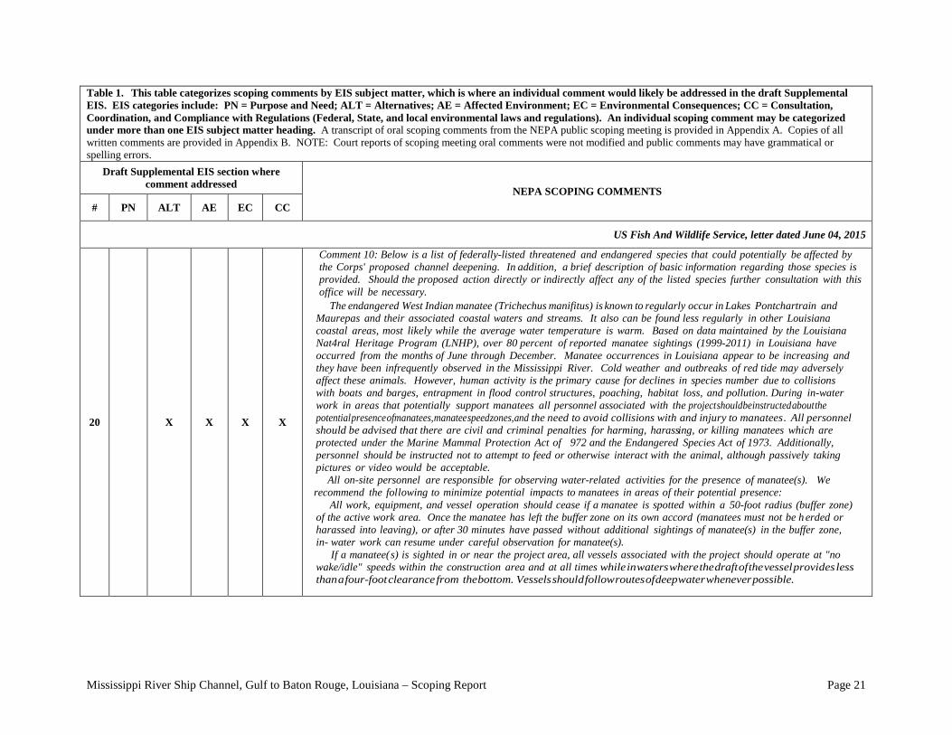
Comment 10: Below is a list of federally-listed threatened and endangered species that could potentially be affected by the Corps' proposed channel deepening. In addition, a brief description of basic information regarding those species is provided. Should the proposed action directly or indirectly affect any of the listed species further consultation with this office will be necessary.
The endangered West Indian manatee ( Trichechus manifitus) is known to regularly occur in Lakes Pontchartrain and Maurepas and their associated coastal waters and streams. It also can be found less regularly in other Louisiana coastal areas, most likely while the average water temperature is warm. Based on data maintained by the Louisiana Nat4ral Heritage Program (LNHP), over 80 percent of reported manatee sightings (1999-2011) in Louisiana have occurred from the months of June through December. Manatee occurrences in Louisiana appear to be increasing and they have been infrequently observed in the Mississippi River. Cold weather and outbreaks of red tide may adversely affect these animals. However, human activity is the primary cause for declines in species number due to collisions with boats and barges, entrapment in flood control structures, poaching, habitat loss, and pollution. During in-water work in areas that potentially support manatees all personnel associated with the project should be instructed about the potential presence of manatees, manatee speed zones, and the need to avoid collisions with and injury to manatees . All personnel should be advised that there are civil and criminal penalties for harming, harassing, or killing manatees which are protected under the Marine Mammal Protection Act of 972 and the Endangered Species Act of 1973. Additionally, personnel should be instructed not to attempt to feed or otherwise interact with the animal, although passively taking pictures or video would be acceptable. All on-site personnel are responsible for observing water-related activities for the presence of manatee(s). We recommend the following to minimize potential impacts to manatees in areas of their potential presence: All work, equipment, and vessel operation should cease if a manatee is spotted within a 50-foot radius (buffer zone) of the active work area. Once the manatee has left the buffer zone on its own accord (manatees must not be h erded or harassed into leaving), or after 30 minutes have passed without additional sightings of manatee(s) in the buffer zone, in- water work can resume under careful observation for manatee(s). If a manatee( s) is sighted in or near the project area, all vessels associated with the project should operate at "no wake/idle" speeds within the construction area and at all times while in waters where the draft of the vessel provides less than a four-foot clearance from the bottom. Vessels should follow routes of deep water whenever possible.
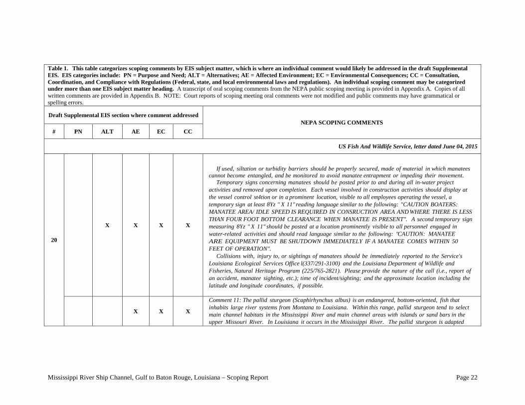
Mississippi River Ship Channel, Gulf to Baton Rouge, Louisiana – Scoping Report Page 22
Table 1. This table categorizes scoping comments by EIS subject matter, which is where an individual comment would likely be addressed in the draft Supplemental EIS. EIS categories include: PN = Purpose and Need; ALT = Alternatives; AE = Affected Environment; EC = Environmental Consequences; CC = Consultation, Coordination, and Compliance with Regulations (Federal, state, and local environmental laws and regulations). An individual scoping comment may be categorized under more than one EIS subject matter heading. A transcript of oral scoping comments from the NEPA public scoping meeting is provided in Appendix A. Copies of all written comments are provided in Appendix B. NOTE: Court reports of scoping meeting oral comments were not modified and public comments may have grammatical or spelling errors. Draft Supplemental EIS section where comment addressed
NEPA SCOPING COMMENTS # PN ALT AE EC CC
US Fish And Wildlife Service, letter dated June 04, 2015
20
X X X X
If used, siltation or turbidity barriers should be properly secured, made of material in which manatees cannot become entangled, and be monitored to avoid manatee entrapment or impeding their movement. Temporary signs concerning manatees should be posted prior to and during all in-water project activities and removed upon completion. Each vessel involved in construction activities should display at the vessel control st4tion or in a prominent location, visible to all employees operating the vessel, a temporary sign at least 8Yz " X 11" reading language similar to the following: "CAUTION BOATERS: MANATEE AREA/ IDLE SPEED IS REQUIRED IN CONSRUCTION AREA AND WHERE THERE IS LESS THAN FOUR FOOT BOTTOM CLEARANCE WHEN MANATEE IS PRESENT". A second temporary sign measuring 8Yz " X 11" should be posted at a location prominently visible to all personnel engaged in water-related activities and should read language similar to the following: "CAUTION: MANATEE ARE EQUIPMENT MUST BE SHUTDOWN IMMEDIATELY IF A MANATEE COMES WITHIN 50 FEET OF OPERATION". Collisions with, injury to, or sightings of manatees should be immediately reported to the Service's Louisiana Ecological Services Office l(337/291-3100) and the Louisiana Department of Wildlife and Fisheries, Natural Heritage Program (225/765-2821). Please provide the nature of the call (i.e., report of an accident, manatee sighting, etc.); time of incident/sighting; and the approximate location including the latitude and longitude coordinates, if possible.
X X X
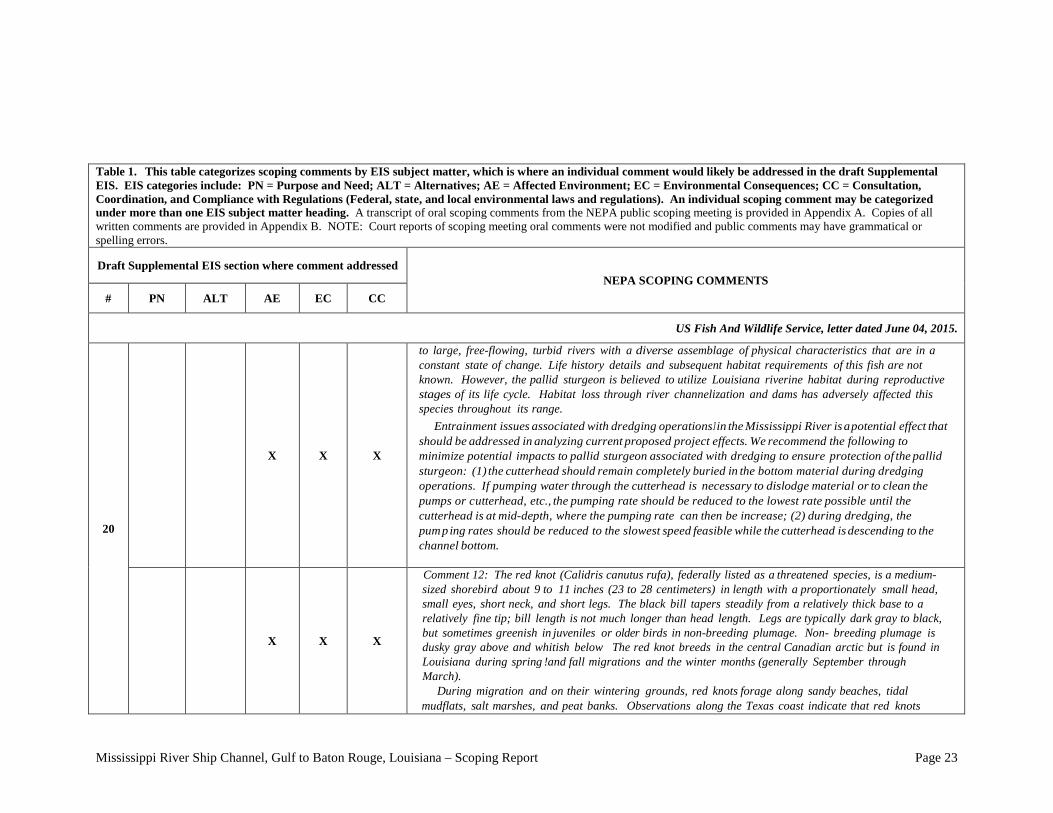
Comment 11: The pallid sturgeon (Scaphirhynchus albus) is an endangered, bottom-oriented, fish that inhabits large river systems from Montana to Louisiana. Within this range, pallid sturgeon tend to select main channel habitats in the Mississippi River and main channel areas with islands or sand bars in the upper Missouri River. In Louisiana it occurs in the Mississippi River. The pallid sturgeon is adapted
Mississippi River Ship Channel, Gulf to Baton Rouge, Louisiana – Scoping Report Page 23
Table 1. This table categorizes scoping comments by EIS subject matter, which is where an individual comment would likely be addressed in the draft Supplemental EIS. EIS categories include: PN = Purpose and Need; ALT = Alternatives; AE = Affected Environment; EC = Environmental Consequences; CC = Consultation, Coordination, and Compliance with Regulations (Federal, state, and local environmental laws and regulations). An individual scoping comment may be categorized under more than one EIS subject matter heading. A transcript of oral scoping comments from the NEPA public scoping meeting is provided in Appendix A. Copies of all written comments are provided in Appendix B. NOTE: Court reports of scoping meeting oral comments were not modified and public comments may have grammatical or spelling errors. Draft Supplemental EIS section where comment addressed
NEPA SCOPING COMMENTS # PN ALT AE EC CC
US Fish And Wildlife Service, letter dated June 04, 2015.
20
X X X
to large, free-flowing, turbid rivers with a diverse assemblage of physical characteristics that are in a constant state of change. Life history details and subsequent habitat requirements of this fish are not known. However, the pallid sturgeon is believed to utilize Louisiana riverine habitat during reproductive stages of its life cycle. Habitat loss through river channelization and dams has adversely affected this species throughout its range. Entrainment issues associated with dredging operations J in the Mississippi River is a potential effect that should be addressed in analyzing current proposed project effects. We recommend the following to minimize potential impacts to pallid sturgeon associated with dredging to ensure protection of the pallid sturgeon: (1) the cutterhead should remain completely buried in the bottom material during dredging operations. If pumping water through the cutterhead is necessary to dislodge material or to clean the pumps or cutterhead, etc., the pumping rate should be reduced to the lowest rate possible until the cutterhead is at mid-depth, where the pumping rate can then be increase; (2) during dredging, the pumping rates should be reduced to the slowest speed feasible while the cutterhead is descending to the channel bottom.
X X X
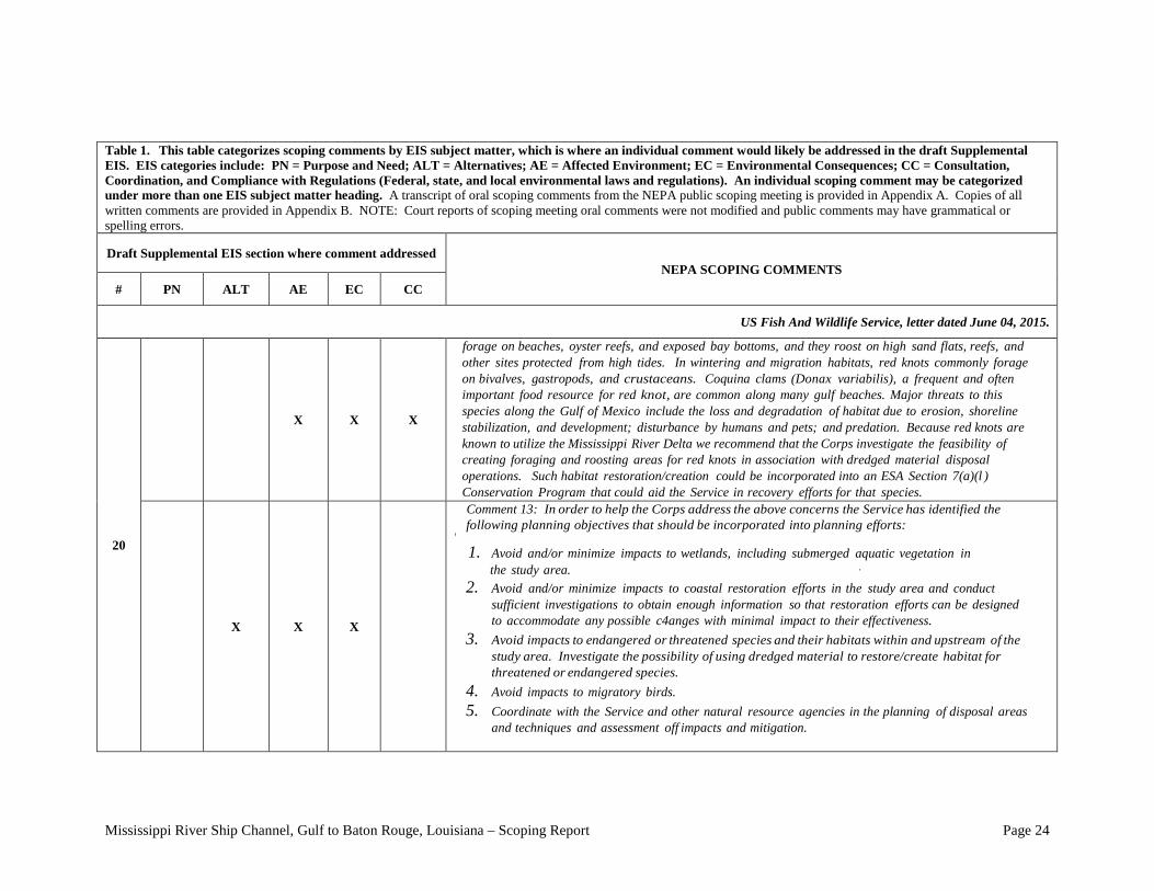
Comment 12: The red knot (Calidris canutus rufa), federally listed as a threatened species, is a medium-sized shorebird about 9 to 11 inches (23 to 28 centimeters) in length with a proportionately small head, small eyes, short neck, and short legs. The black bill tapers steadily from a relatively thick base to a relatively fine tip; bill length is not much longer than head length. Legs are typically dark gray to black, but sometimes greenish in juveniles or older birds in non-breeding plumage. Non- breeding plumage is dusky gray above and whitish below The red knot breeds in the central Canadian arctic but is found in Louisiana during spring !and fall migrations and the winter months (generally September through March). During migration and on their wintering grounds, red knots forage along sandy beaches, tidal mudflats, salt marshes, and peat banks. Observations along the Texas coast indicate that red knots
Mississippi River Ship Channel, Gulf to Baton Rouge, Louisiana – Scoping Report Page 24
Table 1. This table categorizes scoping comments by EIS subject matter, which is where an individual comment would likely be addressed in the draft Supplemental EIS. EIS categories include: PN = Purpose and Need; ALT = Alternatives; AE = Affected Environment; EC = Environmental Consequences; CC = Consultation, Coordination, and Compliance with Regulations (Federal, state, and local environmental laws and regulations). An individual scoping comment may be categorized under more than one EIS subject matter heading. A transcript of oral scoping comments from the NEPA public scoping meeting is provided in Appendix A. Copies of all written comments are provided in Appendix B. NOTE: Court reports of scoping meeting oral comments were not modified and public comments may have grammatical or spelling errors. Draft Supplemental EIS section where comment addressed
NEPA SCOPING COMMENTS # PN ALT AE EC CC
US Fish And Wildlife Service, letter dated June 04, 2015.
20
X X X
forage on beaches, oyster reefs, and exposed bay bottoms, and they roost on high sand flats, reefs, and other sites protected from high tides. In wintering and migration habitats, red knots commonly forage on bivalves, gastropods, and crustaceans. Coquina clams (Donax variabilis), a frequent and often important food resource for red knot, are common along many gulf beaches. Major threats to this species along the Gulf of Mexico include the loss and degradation of habitat due to erosion, shoreline stabilization, and development; disturbance by humans and pets; and predation. Because red knots are known to utilize the Mississippi River Delta we recommend that the Corps investigate the feasibility of creating foraging and roosting areas for red knots in association with dredged material disposal operations. Such habitat restoration/creation could be incorporated into an ESA Section 7(a)(l ) Conservation Program that could aid the Service in recovery efforts for that species.
X X X
Comment 13: In order to help the Corps address the above concerns the Service has identified the following planning objectives that should be incorporated into planning efforts:
' 1. Avoid and/or minimize impacts to wetlands, including submerged aquatic vegetation in
the study area. · 2. Avoid and/or minimize impacts to coastal restoration efforts in the study area and conduct
sufficient investigations to obtain enough information so that restoration efforts can be designed to accommodate any possible c4anges with minimal impact to their effectiveness.
3. Avoid impacts to endangered or threatened species and their habitats within and upstream of the study area. Investigate the possibility of using dredged material to restore/create habitat for threatened or endangered species.
4. Avoid impacts to migratory birds. 5. Coordinate with the Service and other natural resource agencies in the planning of disposal areas
and techniques and assessment off impacts and mitigation.
Mississippi River Ship Channel, Gulf to Baton Rouge, Louisiana – Scoping Report Page 25
Table 1. This table categorizes scoping comments by EIS subject matter, which is where an individual comment would likely be addressed in the draft Supplemental EIS. EIS categories include: PN = Purpose and Need; ALT = Alternatives; AE = Affected Environment; EC = Environmental Consequences; CC = Consultation, Coordination, and Compliance with Regulations (Federal, state, and local environmental laws and regulations). An individual scoping comment may be categorized under more than one EIS subject matter heading. A transcript of oral scoping comments from the NEPA public scoping meeting is provided in Appendix A. Copies of all written comments are provided in Appendix B. NOTE: Court reports of scoping meeting oral comments were not modified and public comments may have grammatical or spelling errors. Draft Supplemental EIS section where comment addressed
NEPA SCOPING COMMENTS # PN ALT AE EC CC
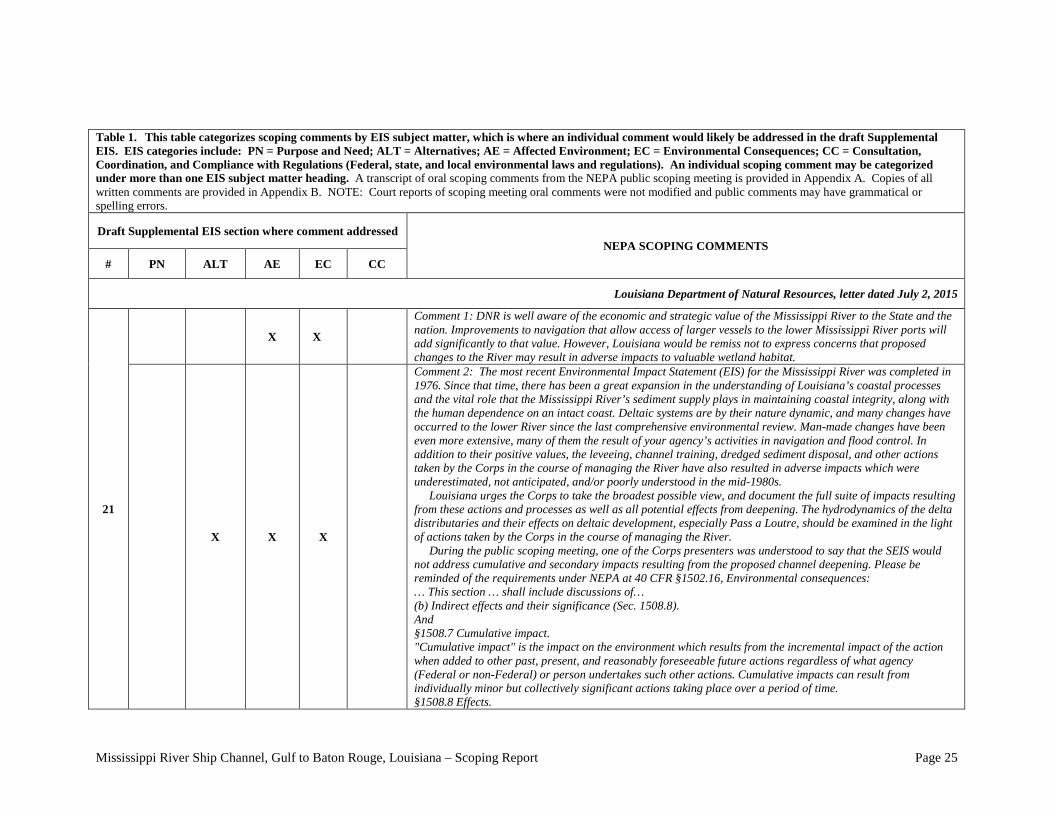
Louisiana Department of Natural Resources, letter dated July 2, 2015
21
X X
Comment 1: DNR is well aware of the economic and strategic value of the Mississippi River to the State and the nation. Improvements to navigation that allow access of larger vessels to the lower Mississippi River ports will add significantly to that value. However, Louisiana would be remiss not to express concerns that proposed changes to the River may result in adverse impacts to valuable wetland habitat.
X X X
Comment 2: The most recent Environmental Impact Statement (EIS) for the Mississippi River was completed in 1976. Since that time, there has been a great expansion in the understanding of Louisiana’s coastal processes and the vital role that the Mississippi River’s sediment supply plays in maintaining coastal integrity, along with the human dependence on an intact coast. Deltaic systems are by their nature dynamic, and many changes have occurred to the lower River since the last comprehensive environmental review. Man-made changes have been even more extensive, many of them the result of your agency’s activities in navigation and flood control. In addition to their positive values, the leveeing, channel training, dredged sediment disposal, and other actions taken by the Corps in the course of managing the River have also resulted in adverse impacts which were underestimated, not anticipated, and/or poorly understood in the mid-1980s. Louisiana urges the Corps to take the broadest possible view, and document the full suite of impacts resulting from these actions and processes as well as all potential effects from deepening. The hydrodynamics of the delta distributaries and their effects on deltaic development, especially Pass a Loutre, should be examined in the light of actions taken by the Corps in the course of managing the River. During the public scoping meeting, one of the Corps presenters was understood to say that the SEIS would not address cumulative and secondary impacts resulting from the proposed channel deepening. Please be reminded of the requirements under NEPA at 40 CFR §1502.16, Environmental consequences: … This section … shall include discussions of… (b) Indirect effects and their significance (Sec. 1508.8). And §1508.7 Cumulative impact. "Cumulative impact" is the impact on the environment which results from the incremental impact of the action when added to other past, present, and reasonably foreseeable future actions regardless of what agency (Federal or non-Federal) or person undertakes such other actions. Cumulative impacts can result from individually minor but collectively significant actions taking place over a period of time. §1508.8 Effects.
Mississippi River Ship Channel, Gulf to Baton Rouge, Louisiana – Scoping Report Page 26
Table 1. This table categorizes scoping comments by EIS subject matter, which is where an individual comment would likely be addressed in the draft Supplemental EIS. EIS categories include: PN = Purpose and Need; ALT = Alternatives; AE = Affected Environment; EC = Environmental Consequences; CC = Consultation, Coordination, and Compliance with Regulations (Federal, state, and local environmental laws and regulations). An individual scoping comment may be categorized under more than one EIS subject matter heading. A transcript of oral scoping comments from the NEPA public scoping meeting is provided in Appendix A. Copies of all written comments are provided in Appendix B. NOTE: Court reports of scoping meeting oral comments were not modified and public comments may have grammatical or spelling errors. Draft Supplemental EIS section where comment addressed
NEPA SCOPING COMMENTS # PN ALT AE EC CC
Louisiana Department of Natural Resources, letter dated July 2, 2015
21
X X X
"Effects" include: (a) Direct effects, which are caused by the action and occur at the same time and place. (b) Indirect effects, which are caused by the action and are later in time or farther removed in distance, but are still reasonably foreseeable. Indirect effects may include growth inducing effects and other effects related to induced changes in the pattern of land use, population density or growth rate, and related effects on air and water and other natural systems, including ecosystems. Effects and impacts as used in these regulations are synonymous. Effects may result from actions which have both beneficial and detrimental effects, even if on balance the agency believes that the effect will be beneficial. Given the obsolescence of the existing environmental document, OCM strongly urges your agency to evaluate the indirect, cumulative, and secondary impacts already experienced along the lower Mississippi River as part of quantifying the existing conditions/no action alternatives, and as a means of anticipating future indirect, cumulative, and secondary impacts which may result from the proposed deepening project.
X X X
Comment 3: The Louisiana Coastal Resources Program (LCRP), this state’s federally-approved coastal management plan, places a high value on the beneficial use of dredged material. As this project moves forward, planning must include the beneficial use not only of the new material dredged in the deepening project, but that which will be generated in future Operations and Maintenance (O&M) activities. Federal regulations at 15 CFR §930.32(a)(1) state: The term “consistent to the maximum extent practicable” means fully consistent with the enforceable policies of management programs unless full consistency is prohibited by existing law applicable to the Federal agency. And in the next paragraph goes on to say … Accordingly, whenever legally permissible, Federal agencies shall consider the enforceable policies of management programs as requirements to be adhered to in addition to existing Federal agency statutory mandates. It is therefore a federal requirement that the cost estimates ultimately submitted for Congressional approval factor in the beneficial use of dredged material as an integral component of this project. In addition, Louisiana recommends that the COE carefully consider potential disposal sites and bear in mind future O&M dredging and disposal with limited funds. Accessible disposal sites should be preserved for future use and, to the extent justified, infrastructure built to enable future O&M at lower costs. Louisiana encourages the COE to consider alternatives such as the installation of a permanent sediment
Mississippi River Ship Channel, Gulf to Baton Rouge, Louisiana – Scoping Report Page 27
Table 1. This table categorizes scoping comments by EIS subject matter, which is where an individual comment would likely be addressed in the draft Supplemental EIS. EIS categories include: PN = Purpose and Need; ALT = Alternatives; AE = Affected Environment; EC = Environmental Consequences; CC = Consultation, Coordination, and Compliance with Regulations (Federal, state, and local environmental laws and regulations). An individual scoping comment may be categorized under more than one EIS subject matter heading. A transcript of oral scoping comments from the NEPA public scoping meeting is provided in Appendix A. Copies of all written comments are provided in Appendix B. NOTE: Court reports of scoping meeting oral comments were not modified and public comments may have grammatical or spelling errors. Draft Supplemental EIS section where comment addressed
NEPA SCOPING COMMENTS # PN ALT AE EC CC
Louisiana Department of Natural Resources, letter dated July 2, 2015
21
X X X disposal pipeline to provide beneficial use opportunities for both the deepening project and future maintenance dredging.
X X X
Comment 3: Currently the State of Louisiana and the COE are conducting modeling of the Mississippi River to identify the best potential coastal restoration measures that can be developed using the Mississippi River. Lowering the river bed may have an effect on river stages, thus the quantity and duration of flows that could be released by a sediment diversion. Louisiana recommends modeling to determine if potential impacts are likely and to quantify their impact on coastal restoration efforts.
Comment 5: Deepening and enlarging channels can result in erosion due to increased channel instability. Also, an increase in the size and number of vessels can exacerbate erosion of shorelines due to wavewash. Louisiana recommends modeling to determine if potential impacts are likely and to quantify their impact on the river system.
X X Comment 6: The increased depth of the channel may increase the frequency of salt water intrusion events. Louisiana recommends modeling to determine if potential impacts are likely and to quantify their effect on coastal Louisiana.
The New Orleans Board of trade, letter dated June 10, 2015
22
Comment 1: We are confident that deepening the Lower Mississippi River will have a positive effect on the maritime industry as well as the economy of both the state and entire nation. On behalf of the membership, The New Orleans Board of Trade would like to go on record as fully supporting the deepening of the Lower Mississippi River from the Sea Buoy to Baton Rouge to fifty (50) feet. We appreciate being allowed to submit this letter of support for this important project.
Chalin Perez, Port Eads Fishing Club, letter dated June 15, 2015
23 X X
Comment 1: I am writing to object to any further dredging at the Head of Passes that does not also include at the same time the actual dredging of South Pass to its approved depth. We are told that the dredgi ng of South Pass has not been done in years simply because of funding. The U. S. Coast Guard abandoned the aids to navigation in South Pass on information that the U. S. Corps of Engineers would not get funding to dredge South Pass. The aids to navigation have been replaced. The present dredging at the
Mississippi River Ship Channel, Gulf to Baton Rouge, Louisiana – Scoping Report Page 28
Table 1. This table categorizes scoping comments by EIS subject matter, which is where an individual comment would likely be addressed in the draft Supplemental EIS. EIS categories include: PN = Purpose and Need; ALT = Alternatives; AE = Affected Environment; EC = Environmental Consequences; CC = Consultation, Coordination, and Compliance with Regulations (Federal, state, and local environmental laws and regulations). An individual scoping comment may be categorized under more than one EIS subject matter heading. A transcript of oral scoping comments from the NEPA public scoping meeting is provided in Appendix A. Copies of all written comments are provided in Appendix B. NOTE: Court reports of scoping meeting oral comments were not modified and public comments may have grammatical or spelling errors. Draft Supplemental EIS section where comment addressed
NEPA SCOPING COMMENTS # PN ALT AE EC CC
Port Eads Fishing Club, letter dated June 15, 2015
23 X X
Head of Passes is causing the silting of South Pass. Some sections are not marked as to the dangers to navigation. Any dredging approval and the funding should include the dredging of South Pass. South Pass had been navigable since the first explorers traveled up the Mississippi River and it is only the dredging at the Head of Passes and the Corps failure to maintain South Pass that the present conditions exist.
The World Trade Center New Orleans, letter dated Jun 15, 2015
24
Comment 1: WTCNO is confident that deepening the river will have a positive effect on Louisiana's economy and ability to facilitate trade, leading to an increase in economic opportunities for the slate and the nation. On behalf of the membership of WTCNO and the WTCA, we would like to go on record as fully supporting the deepening of the Lower Mississippi River, from the Sea Buoy to Baton Rouge, to fifty feet. We appreciate the opportunity to submit this letter of support, as we feel strongly about the positive impact of this project. If you have any additional questions or if we can be of any assistance, please feel free to contact me.
Audubon Society, Coalition to Restore Coastal Louisiana, Environmental Defense Fund, Lake Ponchartrain Basin Foundation, Louisiana Wildlife Federation, and the National Wildlife Federation, letter dated June 15, 2015.
25
Comment 1: At the outset we would make one over-arching observation: efficient and successful navigation of the lower Mississippi River is critical to the US economy, and we strongly support efforts to maintain the competitive advantages for the port systems along the Lower Mississippi River. Those advantages are good for both national and Louisiana interests.
X X X
Comment 2: Within that context, and regarding the scope of this investigation, we strongly urge the U.S. Army Corps of Engineers (USACE) to seize the opportunity to fully integrate this effort with work already underway on the Mississippi River to find the means to successfully forge a united path forward for the people, economy, culture and environment of the Lower Mississippi River. The continuing rate of land loss within the delta coupled with a changing and uncertain future require a new and a management paradigm for the lower river - management that recognizes the need to realistically and pro-actively balance navigation, flood control and the utilization of ecosystem services. The survival of the Lower Mississippi River and its delta depends upon it.
Mississippi River Ship Channel, Gulf to Baton Rouge, Louisiana – Scoping Report Page 29
Table 1. This table categorizes scoping comments by EIS subject matter, which is where an individual comment would likely be addressed in the draft Supplemental EIS. EIS categories include: PN = Purpose and Need; ALT = Alternatives; AE = Affected Environment; EC = Environmental Consequences; CC = Consultation, Coordination, and Compliance with Regulations (Federal, state, and local environmental laws and regulations). An individual scoping comment may be categorized under more than one EIS subject matter heading. A transcript of oral scoping comments from the NEPA public scoping meeting is provided in Appendix A. Copies of all written comments are provided in Appendix B. NOTE: Court reports of scoping meeting oral comments were not modified and public comments may have grammatical or spelling errors. Draft Supplemental EIS section where comment addressed
NEPA SCOPING COMMENTS # PN ALT AE EC CC
Audubon Society, Coalition to Restore Coastal Louisiana, Environmental Defense Fund, Lake Ponchartrain Basin Foundation, Louisiana Wildlife Federation, and the National Wildlife Federation, letter dated June 15, 2015.
25
X X X
Comment 3: Let it not be said of us in the future that by failing to think about and examine the broader implications of the project before us, we made the same mistake here as we made in the past, which was to discount the potential impacts of a project because we so favor the potential benefits.
X X X
Comment 4: This reevaluation study provides a key opportunity to consider the long-term future of the navigation system and to integrate its needs with the ecosystem restoration program and flood control system of the Lower Mississippi River (LMR). This study should intersect with the ongoing Mississippi River Hydrodynamic and Delta Management Study (MRHDM) and the Mississippi River Flowline Study and Water Control Manual Update to create a vision for comprehensive management of the LMR. All three studies are being developed separately by the USACE. Integrating these efforts would be far more effective than treating them as separate factors that are pitted against one another competing for limited financial and natural resources. The long-term sustainability of the navigation channel and the efficacy of the flood storm risk reduction system for millions of people and vital infrastructure relies upon a robust Mississippi River Delta providing ecosystem service such as storm surge attenuation and floodplain management. Comprehensive management of the river can provide more robust means to manage user needs, fitted together to strengthen the whole.
X X X
Comment 5: In order to fully identify and assess the potential direct, indirect and cumulative impacts of this navigational deepening project, it is essential to use the best science available to define baseline conditions of the LMR. It is not a static system. The 2014 MRHDM geomorphic assessment of the LMR by Little and Biedenharn observed significant decadal timescale changes in the stability of the river channel. The reach of the river between Empire and River Mile (RM) 4, part of which will likely require dredging if the channel is deepened to 50-ft, has shifted from a trend where the channel was deepening over time (degradation) in 1960s and 1970s to a trend where the channel is filling in over time (aggradation) in the 1990s and 2000s. This shift to aggradation suggests that this reach of the river channel which might not have required dredging in 1981, would now require dredging to maintain the existing 45-ft channel, let alone 48-ft or 50-ft channel depth. Channel stability is not the only baseline condition of the system that has changed since the 1981 EIS, relative sea level has risen at least 10-inches between 1981 and 2014. This and many other conditions of the river and the surrounding system may have changed since the 1981 study. Compared to 1981, there is much more information available about baseline environmental conditions, such as subsidence, sea level rise, the hydrodynamics and sediment dynamics of the river and how they can affect the
Mississippi River Ship Channel, Gulf to Baton Rouge, Louisiana – Scoping Report Page 30
Table 1. This table categorizes scoping comments by EIS subject matter, which is where an individual comment would likely be addressed in the draft Supplemental EIS. EIS categories include: PN = Purpose and Need; ALT = Alternatives; AE = Affected Environment; EC = Environmental Consequences; CC = Consultation, Coordination, and Compliance with Regulations (Federal, state, and local environmental laws and regulations). An individual scoping comment may be categorized under more than one EIS subject matter heading. A transcript of oral scoping comments from the NEPA public scoping meeting is provided in Appendix A. Copies of all written comments are provided in Appendix B. NOTE: Court reports of scoping meeting oral comments were not modified and public comments may have grammatical or spelling errors. Draft Supplemental EIS section where comment addressed
NEPA SCOPING COMMENTS # PN ALT AE EC CC
Audubon Society, Coalition to Restore Coastal Louisiana, Environmental Defense Fund, Lake Ponchartrain Basin Foundation, Louisiana Wildlife Federation, and the National Wildlife Federation, letter dated June 15, 2015.
25
X X X
navigation channel, infrastructure and the amount and frequency of required dredging and wetland loss and the resulting reduced storm surge buffering capacity of the system. Indeed, in accordance with 40 CFR 1502.9(c)(1)(i), the amount of new information and evidence of changing circumstances relating to a discussion of baseline conditions at the mouth of the river over the next 50 years is so vast compared to the information and analytic capability available in 1981 it is appropriate for the Corps to undertake a robust, new and thorough assessment of current and projected baseline conditions and not view this assessment simply as a “supplement”. This supplemental EIS should use the MRHDM study and others sources of new data and modeling capacity to provide a whole new assessment of these dynamic baseline conditions and how they are affecting the sustainability of the 45-ft channel. In general, the question should be what the implications of these shifting forces are on the integrity and sustainability of the current navigation channel at 45-feet and then use that as starting place to look forward by decade over the next 50 years. Another aspect of the changing environment that an examination of river channel deepening must consider is the delta restoration program that Congress authorized in Title VII of 2007 WRDA and that Louisiana’s2012 Coastal Master Plan (2012 CMP) describes. By the time this supplemental EIS is completed, the State will have made substantial progress on projects selected in the 2012 CMP and made considerable progress on its 2017 Coastal Master Plan. A description of various options for the restoration program and the timing of the implementation of that program is necessary since deepening of the navigation channel could have an impact on the restoration program, and the restoration program could affect the channel and the benefits and costs of maintaining a deeper channel. Since, at a conceptual level, the goal of the restoration program is to convey sediment from the LMR into the delta wetland complex via diversions and/or dredging and pumping, the potential exists to control disposal of sediment in the navigation channel where it requires dredging and to promote deposition at upstream points where the material can be used beneficially via dredging and pumping for sustainable wetland creation higher in the estuarine basins on either side of the lower river.
X X X
Comment 6: The major environmental impacts identified in the 1981 study, marsh loss and salt wedge migration, should be reexamined using information available today. In addition, changes in the hydro and sediment dynamics in the river and storm surge propagation upriver associated with deepening the navigation channel should be investigated. The ongoing MRHDM effort has developed a full suite of modeling tools that should be used in this study, including the local and regional Delft3D models, FVCOM, AdH and HEC-6T. By using the full suite of tools, the forecasted impacts of channel deepening on a local and regional scale can be
Mississippi River Ship Channel, Gulf to Baton Rouge, Louisiana – Scoping Report Page 31
Table 1. This table categorizes scoping comments by EIS subject matter, which is where an individual comment would likely be addressed in the draft Supplemental EIS. EIS categories include: PN = Purpose and Need; ALT = Alternatives; AE = Affected Environment; EC = Environmental Consequences; CC = Consultation, Coordination, and Compliance with Regulations (Federal, state, and local environmental laws and regulations). An individual scoping comment may be categorized under more than one EIS subject matter heading. A transcript of oral scoping comments from the NEPA public scoping meeting is provided in Appendix A. Copies of all written comments are provided in Appendix B. NOTE: Court reports of scoping meeting oral comments were not modified and public comments may have grammatical or spelling errors. Draft Supplemental EIS section where comment addressed
NEPA SCOPING COMMENTS # PN ALT AE EC CC
Audubon Society, Coalition to Restore Coastal Louisiana, Environmental Defense Fund, Lake Ponchartrain Basin Foundation, Louisiana Wildlife Federation, and the National Wildlife Federation, letter dated June 15, 2015.
25 X X
better refined and the effects of shifting conditions and environmental uncertainties on the navigation channel and dredging needs, such as future sea level rise, subsidence, changes in river discharge patterns and changes in precipitations patterns, can be forecasted to estimate the dredging needed to maintain the project alternatives over the 50-years. Salt wedge migration: As part of the 1981 feasibility analysis, a saltwater sill and freshwater holding facilities were considered part of the USACE mitigation responsibility for the adverse impacts of the salt wedge migration upwards within the deeper channel. A sill was constructed in 1988 and again in 2012 at -45-ft, five feet higher than a -50-ft channel and 10-ft higher than a -55-ft channel. A sill constructed at this height is clearly in conflict with the proposed depths of the channel whose purpose is for navigation. Complicating matters further, the borrow source identified with construction of the sill is the same source identified as a borrow site for marsh creation projects within the 2012 CMP. This study should anticipate conflicts in resource needs along the river and develop mutually-agreeable solutions. Marsh loss: The 1981 study presents estimates of the number of acres of marsh near the mouth of the river and over a broader area that are likely to be lost with no deepening of the river below its then depth of 40-ft. That study projected loss of different marsh types without the channel deepening at 10 years intervals. The supplemental EIS should include similar forecasts for changes in marsh acreage with and without project based on the latest information from the USGS 2011 land area change study, the 2012 CMP, and the MRHDM study. Additionally, projections of the number of acres of marsh that would be created by decade with material dredged from the initial channel deepening and maintenance of the project alternatives should be compared with that information with a 50-foot channel in place. The 1981 EIS seemed to assume that new marsh created in this manner was sustainable. In any event, any new marsh created at the mouth would erode and subside just like existing marsh. These processes should be identified, since environmental benefit claims are time sensitive and not permanent. Changes in hydro and sediment dynamics in the river: The deepening of the river channel from 45 to 50-ft may shift the location and quantity of sediment deposited in the LMR channel and the location of bars in the river that have been identified as resources needed for coastal restoration projects. This supplemental study should use the tools developed through the MRDHM study to examine possible changes to the hydro and
Mississippi River Ship Channel, Gulf to Baton Rouge, Louisiana – Scoping Report Page 32
Table 1. This table categorizes scoping comments by EIS subject matter, which is where an individual comment would likely be addressed in the draft Supplemental EIS. EIS categories include: PN = Purpose and Need; ALT = Alternatives; AE = Affected Environment; EC = Environmental Consequences; CC = Consultation, Coordination, and Compliance with Regulations (Federal, state, and local environmental laws and regulations). An individual scoping comment may be categorized under more than one EIS subject matter heading. A transcript of oral scoping comments from the NEPA public scoping meeting is provided in Appendix A. Copies of all written comments are provided in Appendix B. NOTE: Court reports of scoping meeting oral comments were not modified and public comments may have grammatical or spelling errors. Draft Supplemental EIS section where comment addressed
NEPA SCOPING COMMENTS # PN ALT AE EC CC
Audubon Society, Coalition to Restore Coastal Louisiana, Environmental Defense Fund, Lake Ponchartrain Basin Foundation, Louisiana Wildlife Federation, and the National Wildlife Federation, letter dated June 15, 2015.
25
X X X
sediment dynamics of the river due to channel deepening over the 50 year life of the project that could have implications for the delta restoration program, particularly changes that could impact the availability of sediment for sediment diversions and dredging and pumping higher up in the estuarine system. Additionally, this study should collaborate with the MRDHM study to investigate the potential benefits of reduced dredging requirements that could be reaped from sediment diversion projects. The possible impacts of this deepening project on the resources needed for ecosystem restoration and the dredging-reduction benefits that may be derived from sediment diversion projects again highlights the need for an integrated river management that proactively balances navigation, flood protection and ecosystem restoration. Storm surge propagation upriver: Hurricanes can lead to storm surge propagating up the Mississippi River. During Hurricanes Katrina and Isaac, storm surge increased river stage at the USACE Carrollton gage in New Orleans by at least 10-ft and 6-ft, respectively. An important impact to consider as part of this deepening study is the increased storm surge height and distance of propagation upriver that may result, intensifying pressure on the river levees, particularly those in Plaquemines Parish.
X X X
Comment 7: The final selected plan for possible channel deepening should be consistent with the currently approved State Master Plan. It is incumbent for both Federal and State partners to recognize the consistency requirements as they relate to the state master plan and that they endeavor to establish consistency within the execution of the channel deepening study.
X X X X
Comment 8: Mitigation is required under 33 U.S.C. section 2283(d) and the Clean Water Act, for “damages to ecological resources, including terrestrial and aquatic resources, and fish and wildlife losses created by such project” unless the Secretary of the Army issues a written determination that the project will have “negligible adverse impact on ecological resources and fish and wildlife without the implementation of mitigation measures.” In developing the required mitigation plan, the EIS/Re-Evaluation report should consider piping dredged material from the deeper channel upstream further into the Barataria Basin and the Breton Sound Basin where the wetlands created could be more sustainable because of their location in these estuaries and because they could be sustained with sediment delivery into the basins via sediment diversions.
Mississippi River Ship Channel, Gulf to Baton Rouge, Louisiana – Scoping Report Page 33
Table 1. This table categorizes scoping comments by EIS subject matter, which is where an individual comment would likely be addressed in the draft Supplemental EIS. EIS categories include: PN = Purpose and Need; ALT = Alternatives; AE = Affected Environment; EC = Environmental Consequences; CC = Consultation, Coordination, and Compliance with Regulations (Federal, state, and local environmental laws and regulations). An individual scoping comment may be categorized under more than one EIS subject matter heading. A transcript of oral scoping comments from the NEPA public scoping meeting is provided in Appendix A. Copies of all written comments are provided in Appendix B. NOTE: Court reports of scoping meeting oral comments were not modified and public comments may have grammatical or spelling errors. Draft Supplemental EIS section where comment addressed
NEPA SCOPING COMMENTS # PN ALT AE EC CC
Audubon Society, Coalition to Restore Coastal Louisiana, Environmental Defense Fund, Lake Ponchartrain Basin Foundation, Louisiana Wildlife Federation, and the National Wildlife Federation, letter dated June 15, 2015.
25 X X X
Comment 9: The National Water Resources Planning Policy established by Congress in 2007 states that “all water resources projects” shall “protect and restore the functions of natural systems and mitigate any unavoidable damage to natural systems.” 33 U.S.C 1962-3 (established by § 2031(a) of the Water Resources Development Act of 2007, and immediately applicable to all water resources projects). Accordingly, this SEIS must evaluate alternatives that would promote protection and restoration of the natural land-building and Delta wetland preservation functions of the Mississippi River, and must ultimately select an alternative that is consonant with these objectives. In combination with the “no action”, 48-ft navigation channel and a 50-ft navigation channel alternatives outlined in the scoping notice, this study should therefore also consider, in each alternative, the possibility for the integrated use of sediment diversion projects to help defray the costs of maintaining a deeper navigation channel and to restore and preserve Delta wetlands. Thus, consistent with the purpose of an investigation of reasonable alternatives as set forth in ER 1105-2-100 G-16(14) and 40 CFR 1502.14(a) and 1508.25 and the requirements of the National Water Resources Planning Policy, the EIS should present as an alternative a broader framework for assessing the proposed deepening of the navigation channel that looks at the relationships between navigation, flood control, risk reduction and ecosystem restoration actions and strategies for integrating those actions and making them mutually supportive. Today they are often in conflict. This framework should recognize the long-term dependency of the navigation system on a healthy delta ecosystem. The reevaluation of a deeper channel provides an opportunity to advance thinking about better ways of managing the LMR to achieve multiple purposes rather than one purpose at a time. Indeed, evaluating the 50-ft channel in this broader LMR management context is the only way to assure its long-term sustainability.
Mississippi River Ship Channel, Gulf to Baton Rouge, Louisiana – Scoping Report Page 34
Table 1. This table categorizes scoping comments by EIS subject matter, which is where an individual comment would likely be addressed in the draft Supplemental EIS. EIS categories include: PN = Purpose and Need; ALT = Alternatives; AE = Affected Environment; EC = Environmental Consequences; CC = Consultation, Coordination, and Compliance with Regulations (Federal, state, and local environmental laws and regulations). An individual scoping comment may be categorized under more than one EIS subject matter heading. A transcript of oral scoping comments from the NEPA public scoping meeting is provided in Appendix A. Copies of all written comments are provided in Appendix B. NOTE: Court reports of scoping meeting oral comments were not modified and public comments may have grammatical or spelling errors. Draft Supplemental EIS section where comment addressed
NEPA SCOPING COMMENTS # PN ALT AE EC CC
Louisiana Coastal Protection and Restoration Authority, letter dated July 1, 2015
26
X X X
Comment 1: The focus of the SEIS/GRS for this proposed action seems constrained to an analysis of the economic benefits of a deeper channel against the cost of constructing and maintaining the deeper channel. There is no apparent consideration for the need to establish a new environmental baseline in response to drastic alterations in the affected landscape that have occurred subsequent to the original 1981 Feasibility Study and EIS for the MRSC. CPRA is also concerned that this new study does not seem to consider the interaction of channel deepening with proposed coastal restoration efforts that aim to make use of Lower Mississippi River sediment and water resources.
X X X
Comment 2: CPRA strongly supports the integration of the Louisiana Coastal Area Mississippi River Hydrodynamic and Delta Management (MRHDM) Study body of knowledge and evaluation tools with the proposed SEIS/Reevaluation Study. The products of the MRHDM Study represent millions of dollars and many years of cooperative effort between the United States Army Corps of Engineers and CPRA, manifested as the most detailed understanding of physical processes in the LMR to date and state of the art hydrodynamic modeling tools of the LMR channel and adjacent basins.
Port of New Orleans, letter dated July 15, 2015
27 X X
Comment 1: I t is anticipated that the GRR will confirm a Channel depth of SO feet. The Board intends to seek authorization in the next WRRDA to dredge the Harbor to the same depth as the Channel. The same data are required to study both the Channel and Harbor so i t i s reasonable to consider them simultaneously and it would take very little effort on the part of the Corps. Doing otherwise would be an inefficient use of Corps resources requiring an additional GRR for Harbor deepening and would unnecessarily delay the ultimate realization of the full benefit of a deeper Channel to the Port of New Orleans. The Board respectfully requests that the Corps include an evaluation of deepening the Harbor to SO feet in the current GRR. Should you require additional information or wish to discuss this request further, please contact Ms. Andree Fant at S04-S28-3321 or [email protected] .
Mississippi River Ship Channel, Gulf to Baton Rouge, Louisiana – Scoping Report Page 35
Table 1. This table categorizes scoping comments by EIS subject matter, which is where an individual comment would likely be addressed in the draft Supplemental EIS. EIS categories include: PN = Purpose and Need; ALT = Alternatives; AE = Affected Environment; EC = Environmental Consequences; CC = Consultation, Coordination, and Compliance with Regulations (Federal, state, and local environmental laws and regulations). An individual scoping comment may be categorized under more than one EIS subject matter heading. A transcript of oral scoping comments from the NEPA public scoping meeting is provided in Appendix A. Copies of all written comments are provided in Appendix B. NOTE: Court reports of scoping meeting oral comments were not modified and public comments may have grammatical or spelling errors. Draft Supplemental EIS section where comment addressed
NEPA SCOPING COMMENTS # PN ALT AE EC CC
Big River Coalition, letter dated July 16, 2015
28
X
Comment 1: The successful construction of the saltwater barrier on an average of every nine years has prevented the saltwater wedge from fouling the water intakes for the city of New Orleans as designed. Therefore, the saltwater sill should ameliorate any concerns about the saltwater wedge even if it has to be constructed more frequently.
Comment 2: The Big River Coalition applauds the United States Army Corps’ of Engineers (Mississippi Valley New Orleans) and the Louisiana Department of Transportation and Development for undertaking this historic effort. The Coalition remains indebted to our federal and state project sponsors and will continue to assist with the process and to provide documentation as requested.
Page 36
8.0 SUMMARY OF SCOPING COMMENTS
The concerns expressed at the public scoping meeting are summarized below. The primary concerns expressed by scoping participants regard the project alternatives, environmental consequences and affected environment, followed closely by the project alternatives and consultation and coordination, and purpose and need only slightly regarded as important. In general, all parties that presented comments were in favor of the project. However, some parties also raised serious concerns over an array of environmental uncertainties and potential negative impacts.
Local residents provided comments and questions regarding the affect on the local communities in Plaquemines Parish. A common concern was raised about the need for beneficial use of dredged material, especially in areas south of Venice. Residents were also concerned about the potential negative effects of saltwater contamination on water supply.
There were multiple comments from industry and maritime representatives stressing the need for deepening and widening the river, as well as a need for improved maintenance. Concerns were also raised concerning the effects of future diversions on the navigability of the lower Mississippi River. Some concerns were raise about the need to dredge Pass Loutre and South Pass and questions were raised as to if the new study would include such maintenance.
The state of Louisiana and a coalition of Environmental NGO’s also presented insightful questions and comments during scoping. One common recommendation was to coordinate closely with Louisiana Coastal Protection and Restoration Authority to assure the project is in alignment with the Louisiana State Master Plan and be cohesive with the long term management of the lower Mississippi River. It was expressed that effective coordination would prevent future conflict of the ownership of resources in the river. Concerns about the potential for erosion and increased channel instability, and the most effective placement of material that would be used beneficially for purposes of coastal restoration were shared. Concerns that channel deepening may also effect salt wedge migration, marsh loss, storm surge upriver, and changes in dynamics of the river were also raised.
The last major category of comments dealt with dredging and the environmental impacts of the project. The US Fish and Wildlife Service submitted a letter providing a list of detailed comments to assist CEMVN during project planning and construction. The Service raised valid concerns and provided useful comments on issues concerning public lands, coastal restoration, mitigation efforts, increased erosion, endangered species, migratory birds, saltwater intrusion mitigation.
9.0 CONCLUSIONS
The scoping comments described herein will be addressed in the significant issues, range of alternatives, and consultation and coordination sections of the draft Supplemental EIS. Some comments are outside the scope of this project and CEMVN will consider them in consultation and coordination, where appropriate. The draft Supplemental EIS will be distributed for public comment and interagency review for a minimum of 45 days, which is anticipated to begin in August of 2016.
Mississippi River Ship Channel, Gulf to Baton Rouge, Louisiana – Scoping Report