Embed Size (px)
Citation preview
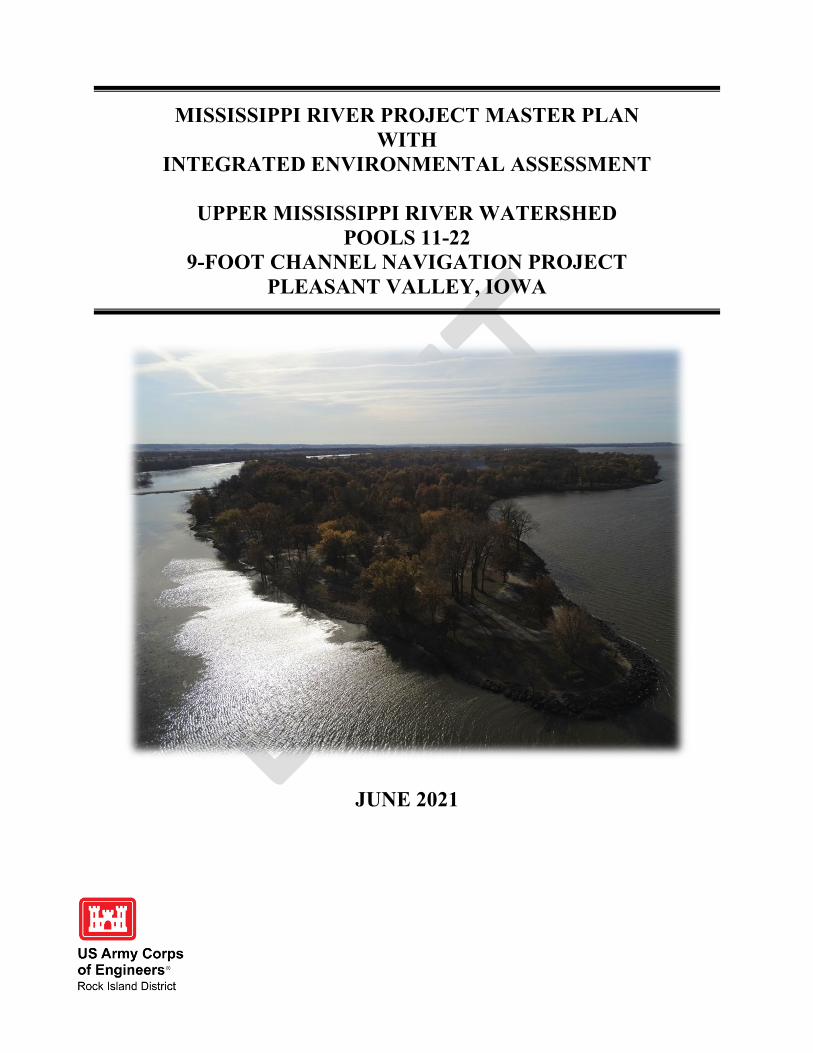
MISSISSIPPI RIVER PROJECT MASTER PLAN WITH
INTEGRATED ENVIRONMENTAL ASSESSMENT
UPPER MISSISSIPPI RIVER WATERSHED POOLS 11-22
9-FOOT CHANNEL NAVIGATION PROJECT PLEASANT VALLEY, IOWA
JUNE 2021
US Army Corps of Engineers® Rock Island District
I
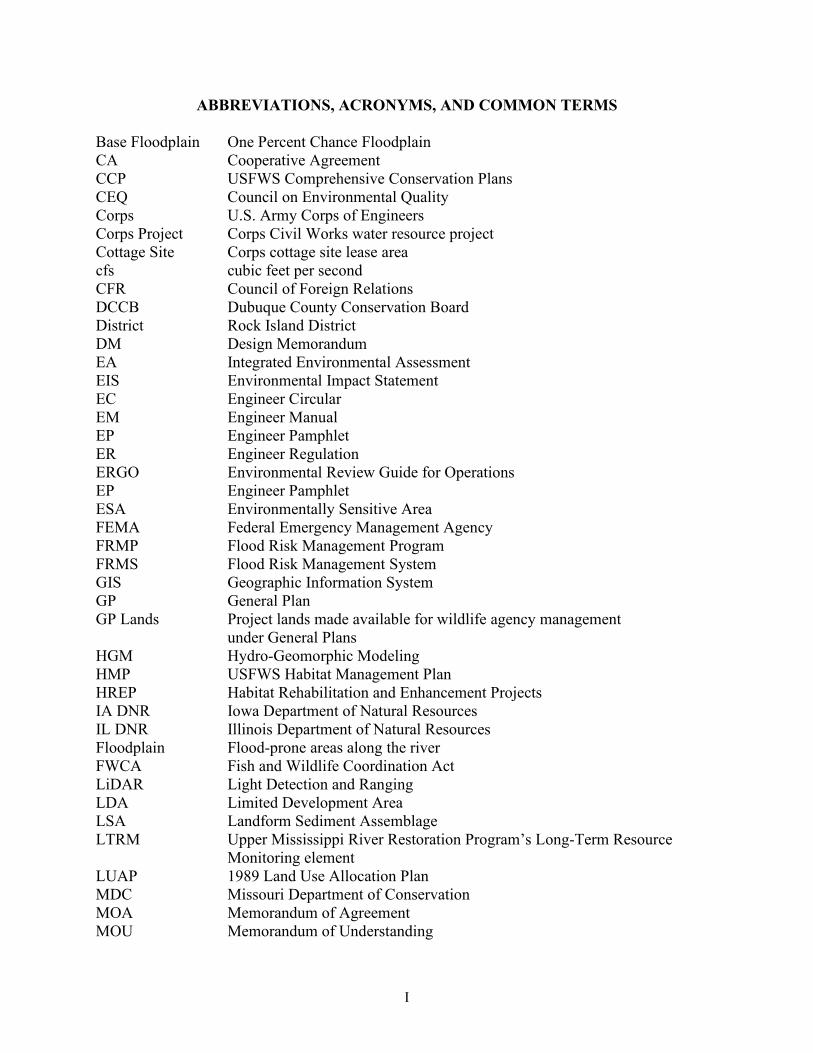
ABBREVIATIONS, ACRONYMS, AND COMMON TERMS Base Floodplain One Percent Chance Floodplain CA Cooperative Agreement CCP USFWS Comprehensive Conservation Plans CEQ Council on Environmental Quality Corps U.S. Army Corps of Engineers Corps Project Corps Civil Works water resource project Cottage Site Corps cottage site lease area cfs cubic feet per second CFR Council of Foreign Relations DCCB Dubuque County Conservation Board District Rock Island District DM Design Memorandum EA Integrated Environmental Assessment EIS Environmental Impact Statement EC Engineer Circular EM Engineer Manual EP Engineer Pamphlet ER Engineer Regulation ERGO Environmental Review Guide for Operations EP Engineer Pamphlet ESA Environmentally Sensitive Area FEMA Federal Emergency Management Agency FRMP Flood Risk Management Program FRMS Flood Risk Management System GIS Geographic Information System GP General Plan GP Lands Project lands made available for wildlife agency management under General Plans HGM Hydro-Geomorphic Modeling HMP USFWS Habitat Management Plan HREP Habitat Rehabilitation and Enhancement Projects IA DNR Iowa Department of Natural Resources IL DNR Illinois Department of Natural Resources Floodplain Flood-prone areas along the river FWCA Fish and Wildlife Coordination Act LiDAR Light Detection and Ranging LDA Limited Development Area LSA Landform Sediment Assemblage LTRM Upper Mississippi River Restoration Program’s Long-Term Resource Monitoring element LUAP 1989 Land Use Allocation Plan MDC Missouri Department of Conservation MOA Memorandum of Agreement MOU Memorandum of Understanding

II
MP Master Plan NEPA National Environmental Policy Act NHPA National Historic Preservation Act NRHP National Register of Historic Places NRM Natural Resources Management NWR National Wildlife Refuge NWFR National Wildlife and Fish Refuge OMP Operational Management Plan Outgrant Corps Real Estate Instrument for Use of Project Lands PL Public Law Pool Navigation pool created upstream of a lock and dam Project Mississippi River Nine-Foot Channel Navigation Project Project Lands Federal fee title tracts acquired for the Project and associated accreted lands R1S Recreation One Stop RM River Mile ROW Rights of Way SMP Shoreline Management Plan SHPO State Historic Preservation Office UMR Upper Mississippi River UMRR Upper Mississippi River Restoration Program UMRS Upper Mississippi River System UMRSFSP Upper Mississippi River Systemic Forest Stewardship Plan USEPA U.S. Environmental Protection Agency USFWS U.S. Fish and Wildlife Service USGS United States Geological Survey VMA Vegetative Management Area WMA Wildlife Management Area WRDA Water Resources Development Act

i
MISSISSIPPI RIVER PROJECT MASTER PLAN WITH
INTEGRATED ENVIRONMENTAL ASSESSMENT
TABLE OF CONTENTS
Page numbers will be added upon Public Review CHAPTER 1. INTRODUCTION ........................................................................................ 1-1 1.1. Project Authorizations ............................................................................................................ 1.2. Project Purposes .....................................................................................................................
1.2.1. Navigation .................................................................................................................. 1.2.2. Natural Resources ...................................................................................................... 1.2.3. Environmental Stewardship ....................................................................................... 1.2.4. Recreation ..................................................................................................................
1.3. Purpose, Need and Scope of the Master Plan ....................................................................... 1.3.1. Planning Separate From the Master Plan ...................................................................
1.4. Mississippi River Watershed.................................................................................................. 1.4.1. Upper Mississippi River Watershed ..........................................................................
1.5. Floodplain Along the Mississippi River Project .................................................................... 1.5.1. Project Administration .................................................................................................
1.6. Prior Design Memoranda and Master Planning Documents .................................................. 1.7. Pertinent Project Information ................................................................................................ CHAPTER 2. PROJECT SETTING, FACTORS INFLUENCING ................................ 2-1 MANAGEMENT AND DEVELOPMENT (AFFECTED ENVIRONMENT) 2.1. Introduction ............................................................................................................................
2.1.1. Public Lands ................................................................................................................ 2.1.2. Public Waters ............................................................................................................... 2.1.3. Shoreline ...................................................................................................................... 2.1.4. Easements ....................................................................................................................
2.2. Description of Navigation Pools ............................................................................................ 2.3. River Hydrological Characteristics ........................................................................................
2.3.1. Pooled River ................................................................................................................ 2.3.2. Mississippi River Within the Project ........................................................................... 2.3.3. Annual River Discharge ..............................................................................................
2.4. Sedimentation & Shoreline Erosion ....................................................................................... 2.5. Water Quality .........................................................................................................................
2.5.1. Non-Point Source Pollution ......................................................................................... 2.5.2. Point Source Pollution ................................................................................................. 2.5.3. Environmental Spills ...................................................................................................
2.6. Climate & Weather ................................................................................................................ 2.7. Topography, Geology, and Soils ............................................................................................
2.7.1. Geology and Topography ...........................................................................................

Mississippi River Project Master Plan With Integrated Environmental Assessment
ii
2.7.2. Topography ................................................................................................................ 2.7.3. Soils............................................................................................................................
2.8. Resource Analysis (Level One and Two Inventories) ........................................................... 2.8.1. Fish & Wildlife Resources ......................................................................................... 2.8.2. Vegetative Resources ................................................................................................. 2.8.3. Wetlands .................................................................................................................... 2.8.4. Threatened & Endangered Species ............................................................................ 2.8.5. Invasive Species ......................................................................................................... 2.8.6. Ecological Setting ......................................................................................................
2.9. Cultural Resources ................................................................................................................. 2.10. Demographics ......................................................................................................................
2.10.1. Population ............................................................................................................... 2.10.2. Housing .................................................................................................................. 2.10.3. Income & Education ............................................................................................... 2.10.4. Race and Origin ......................................................................................................
2.12. Recreation Facilities, Activities, and Needs ........................................................................ 2.12.1. Recreation Areas ...................................................................................................... 2.12.2. Zones of Influence ................................................................................................... 2.12.3. Visitation Profile ..................................................................................................... 2.12.4. Recreational Carrying Capacity and Analysis .........................................................
2.13. Real Estate .......................................................................................................................... 2.13.1. Acquisition Policy .................................................................................................. 2.13.2. Outgrants On Public Lands ................................................................................... 2.13.3. Corps Easements On Private Lands ....................................................................... 2.13.4. Operation On Other Public Lands ......................................................................... 2.13.5. New Non-Recreational Outgrant Proposals ...........................................................
2.14. Pertinent Public Laws ......................................................................................................... CHAPTER 3. RESOURCE OBJECTIVES ....................................................................... 3-1 3.1. Background ............................................................................................................................ 3.2. Resource Vision ..................................................................................................................... 3.3. Resource Goals ...................................................................................................................... 3.4. Resource Objectives...............................................................................................................
3.4.1. Environmental Stewardship Resource Objectives ..................................................... 3.4.2. Recreation Resource Objectives ................................................................................
3.5. Implementation of Objectives ................................................................................................ CHAPTER 4. LAND ALLOCATION, LAND CLASSIFICATION, WATER .............. 4-1 SURFACE, AND PROJECT EASEMENT LANDS 4.1. Land Allocation ..................................................................................................................... 4.2. Shoreline Management Allocation ........................................................................................ 4.3. Land Use Classification ......................................................................................................... 4.3.1. Project Operations ....................................................................................................... 4.3.2. High Density Recreation ............................................................................................. 4.3.3. Mitigation ................................................................................................................... 4.3.4. Environmentally Sensitive Areas ................................................................................

Mississippi River Project Master Plan With Integrated Environmental Assessment
iii
4.3.5. Multiple Resource Management Lands ....................................................................... 4.3.6. Water Surface .............................................................................................................. 4.3.7. Project Easement ......................................................................................................... 4.3.8. Additional Administrative Details ............................................................................... 4.3.9. Land Use Classification Summary .............................................................................. CHAPTER 5. RESOURCE PLAN ...................................................................................... 5-1 5.1. General ................................................................................................................................... 5.2. Master Plan Alternatives ........................................................................................................
5.2.1. Alternative 1 - No Action Alternative ......................................................................... 5.2.2. Alternative 2 - Preferred Alternative-Existing Conditions Focus ............................... 5.2.3. Alternative 3 - Conservation Alternative ..................................................................... 5.2.4. Alternative 4 - Recreation Alternative......................................................................... 5.2.5. Comparison of Alternatives .........................................................................................
5.3. Preferred Alternative Resource Plan ......................................................................................
CHAPTER 6. SPECIAL TOPICS, PLANNING CONSIDERATIONS, ......................... 6-1 AND SPECIAL CONCERNS 6.1. General Plans and Cooperative Agreements .......................................................................... 6.2. Upper Mississippi River Restoration Program Habitat Rehabilitation and ........................... Enhancement Projects 6.3. Forest Stewardship Planning .................................................................................................. 6.4. Hydro-Geomorphic Modeling ................................................................................................ 6.5. Outgrants ................................................................................................................................
6.5.1. Outgrant Guidelines ..................................................................................................... 6.5.2. Non - Recreation Outgrants ......................................................................................... 6.5.3. Recreation Outgrant Development Policy ...................................................................
6.6. Barge Fleeting ........................................................................................................................ 6.6.1. Barge Fleeting Defined .............................................................................................. 6.6.2. Regulatory and Real Estate Approval Process ...........................................................
6.7. Mississippi River Project Boundary ...................................................................................... 6.7.1. Background ................................................................................................................ 6.7.2. Boundary Maintenance ..............................................................................................
6.7.3. Outreach Activities.............................................................................................................. 6.7.4. Encroachments .................................................................................................................... 6.7.5. Mapping Changes Due to River Processes ........................................................................ 6.8. Volunteers and Partnerships ................................................................................................... 6.9. Water Trail ............................................................................................................................. 6.10. Visitor Center ....................................................................................................................... 6.11. Utilities ................................................................................................................................. 6.12. Mitigation ............................................................................................................................. 6.13. Private Exclusive Use and Private Shoreline Use ................................................................
6.13.1. Shoreline Management ............................................................................................ 6.13.2. Cottage Sites. .......................................................................................................... 6.13.3. Overnight Occupancy of Vessels and Floating Structures .......................................
6.14. Dredged Material Placement Areas .....................................................................................

Mississippi River Project Master Plan With Integrated Environmental Assessment
iv
6.15. Flood Risk Management Systems and Flowage Easement Overlap .................................... CHAPTER 7. AGENCY AND PUBLIC COORDINATION ........................................... 7-1 7.1. Agency and Public Coordination ........................................................................................... 7.2. Agency Scoping Meetings ..................................................................................................... 7.3. Tribal Coordination ............................................................................................................... 7.4. Public Scoping Meetings ....................................................................................................... 7.5. Posting of Draft Master Plan and Public Comment Period ................................................... CHAPTER 8. ALTERNATIVES & COMPARISON OF POTENTIAL ........................ 8-1 ENVIRONMENTAL IMPACTS 8.1. Decision To Be Made ............................................................................................................ 8.2. The Planning Team ................................................................................................................ 8.3. Issues/Concerns That Arose During Agency and Public Scoping ......................................... 8.4. Future Recommended Management Actions ......................................................................... 8.5. Alternatives Including The Proposed Action ......................................................................... 8.6. No-Action (Alternative 1) ...................................................................................................... 8.7. Existing Conditions Focus (Alternative 2 – Preferred) .......................................................... 8.8. Conservation Focus (Alternative 3) ....................................................................................... 8.10. Alternatives Not Carried Forward For Further Analysis ..................................................... 8.11. Evaluation of Alternatives and Selection of Preferred Alternative .................................... 8.12. Comparison of Effects of Alternatives By Resource ..........................................................
8.12.1. Environmental Impacts ........................................................................................... 8.12.2. Probable Adverse Effects Which Cannot Be Avoided ........................................... 8.12.3. Relationship Between Short-Term Use and Long-Term Productivity ................... 8.12.4. Irreversible or Irretrievable Commitment of Resources if the Project Is ............... Implemented ........................................................................................................... 8.12.5. Relationship of the Proposed Project to Land-Use Plans ....................................... 8.12.6. Indirect and Cumulative Impacts of the Preferred Alternative .............................. 8.12.7. Compliance With Environmental Quality Statutes ................................................
CHAPTER 9. SUMMARY OF RECOMMENDATIONS ................................................ 9-1 9.1. General Background .............................................................................................................. 9.2. Land Classification Changes ..................................................................................................
9.2.1. Recreation Changes ..................................................................................................... 9.3. Modernization of Recreation Facilities .................................................................................. 9.4. Implementation of The Master Plan: Operational Management Plans .................................. 9.5. Non-Recreation Outgrant Policy............................................................................................ 9.6. Recommendations .................................................................................................................. 9.7. Conclusion ............................................................................................................................. 9.8. Further Management Studies .................................................................................................
Mississippi River Project Master Plan With Integrated Environmental Assessment
v
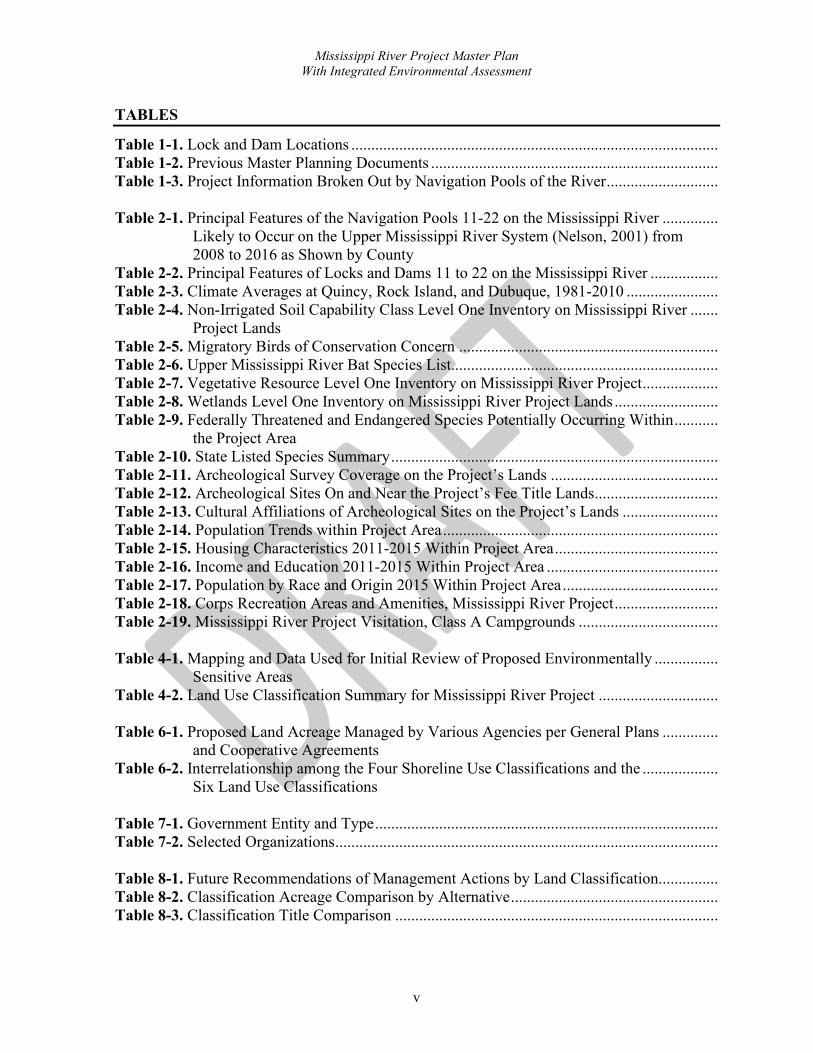
TABLES
Table 1-1. Lock and Dam Locations ............................................................................................ Table 1-2. Previous Master Planning Documents ........................................................................ Table 1-3. Project Information Broken Out by Navigation Pools of the River ............................ Table 2-1. Principal Features of the Navigation Pools 11-22 on the Mississippi River .............. Likely to Occur on the Upper Mississippi River System (Nelson, 2001) from 2008 to 2016 as Shown by County Table 2-2. Principal Features of Locks and Dams 11 to 22 on the Mississippi River ................. Table 2-3. Climate Averages at Quincy, Rock Island, and Dubuque, 1981-2010 ....................... Table 2-4. Non-Irrigated Soil Capability Class Level One Inventory on Mississippi River ....... Project Lands Table 2-5. Migratory Birds of Conservation Concern ................................................................. Table 2-6. Upper Mississippi River Bat Species List................................................................... Table 2-7. Vegetative Resource Level One Inventory on Mississippi River Project ................... Table 2-8. Wetlands Level One Inventory on Mississippi River Project Lands .......................... Table 2-9. Federally Threatened and Endangered Species Potentially Occurring Within ........... the Project Area Table 2-10. State Listed Species Summary .................................................................................. Table 2-11. Archeological Survey Coverage on the Project’s Lands .......................................... Table 2-12. Archeological Sites On and Near the Project’s Fee Title Lands............................... Table 2-13. Cultural Affiliations of Archeological Sites on the Project’s Lands ........................ Table 2-14. Population Trends within Project Area ..................................................................... Table 2-15. Housing Characteristics 2011-2015 Within Project Area ......................................... Table 2-16. Income and Education 2011-2015 Within Project Area ........................................... Table 2-17. Population by Race and Origin 2015 Within Project Area ....................................... Table 2-18. Corps Recreation Areas and Amenities, Mississippi River Project .......................... Table 2-19. Mississippi River Project Visitation, Class A Campgrounds ................................... Table 4-1. Mapping and Data Used for Initial Review of Proposed Environmentally ................ Sensitive Areas Table 4-2. Land Use Classification Summary for Mississippi River Project .............................. Table 6-1. Proposed Land Acreage Managed by Various Agencies per General Plans .............. and Cooperative Agreements Table 6-2. Interrelationship among the Four Shoreline Use Classifications and the ................... Six Land Use Classifications Table 7-1. Government Entity and Type ...................................................................................... Table 7-2. Selected Organizations ................................................................................................ Table 8-1. Future Recommendations of Management Actions by Land Classification............... Table 8-2. Classification Acreage Comparison by Alternative .................................................... Table 8-3. Classification Title Comparison .................................................................................

Mississippi River Project Master Plan With Integrated Environmental Assessment
vi
Table 8-4. Area Proposed for Environmentally Sensitive Area Classification Under ................. Alternative 2, Preferred Alternative Table 8-5. Environmental Impacts of the Four Alternatives ........................................................ Table 8-6. Compliance with Environmental Protection Statutes and Other ................................ Environmental Requirements FIGURES
Figure 1-1. Lock & Dam Locations on the Upper Mississippi River System ............................. Figure 1-2. The Mississippi River Basin ..................................................................................... Figure 2-1. Number of Top 100 Flood Crests by Decade since 1900 at Hannibal, ..................... as Shown by State Residence Figure 2-2. Project Land Cover Types Subject to Flooding ........................................................ Figure 2-3. The 303d List of Impaired Water Bodies as of 2008 ................................................ Figure 2-4. Average Monthly Temperatures and Precipitation for Rock Island, IL, ................... From 1981-2010 Figure 2-5. Temperatures Rising in the Midwest ........................................................................ Figure 2-6. Land Cover Category Summary for Project Fee Title Lands .................................... Figure 2-7. Hypothetical Floodplain Cross Section Illustration of Habitat Types ...................... Figure 2-8. Visitor Numbers for Camping at Project Class A Campgrounds from ..................... 2008 to 2016 Figure 2-9. Low to High Visitation for Camping at Project Class A Campgrounds ................... Figure 8.1. Percentage of Response from Four Public Scoping Questions ................................. Figure 8-2. 1989 Management ..................................................................................................... Figure 8-3. Alternative 1 Classification ....................................................................................... Figure 8-4. Alternative 2 Management ........................................................................................ Figure 8-5. Alternative 2 Classification ....................................................................................... Figure 8-6. Classification Breakdown of Areas Directly Managed by the Corps ....................... Figure 8-7. Fee Title Lands Percent of Acreage Under Water or Subject to Flooding ............... Figure 8-8. Alternative 3 Management ........................................................................................ Figure 8-9. Alternative 3 Classification ....................................................................................... Figure 8-10. Alternative 4 Management ...................................................................................... Figure 8-11: Alternative 4 Classification..................................................................................... Figure 8-12. Connection Between the Master Plan, Operational Management Plans, ................ and Specific Natural Resource Management Plans

Mississippi River Project Master Plan With Integrated Environmental Assessment
vii
APPENDICES
Appendix A Approval Documentation Appendix B Agency and Public Coordination Appendix C Design Memorandums Appendix D Applicable Federal Standards Appendix E Bibliography Appendix F August 2012 Upper Mississippi River Systemic Forest Stewardship Plan Appendix G 1989 Shoreline Management Plan Appendix H Listed Species Appendix I 1982 Forest, Fish, and Wildlife Management Plan Appendix J Land Use Classification and Management Plates Appendix K General Plans Plates - Pools 11-13, Pools 14-22

1-1
MISSISSIPPI RIVER PROJECT MASTER PLAN WITH
INTEGRATED ENVIRONMENTAL ASSESSMENT
CHAPTER 1
INTRODUCTION
1.1. PROJECT AUTHORIZATIONS
The U.S. Army Corps of Engineers (Corps), Rock Island District (District), Mississippi River Nine-Foot Channel Navigation Project (Project) was originally authorized by the Rivers and Harbors Act of 1930 (Seventy-First Congress, Session 2, Chapter 847). The administrative portion of the Project associated with this Master Plan (MP) is Pools 11 through 22 and the associated Federal fee title land (Project lands) and easement interests acquired for the Project within the boundaries of the District between river mile (RM) 300.0 (approximately 1 mile downstream of Lock and Dam 22) and RM 614.0 (approximately 1 mile below Lock and Dam 10). Project lands also include accreted lands adjoining and associated with acquired Federal fee title tracts.
1.2. PROJECT PURPOSES
1.2.1. Navigation. The Project was originally constructed for the sole purpose of a continuous navigable channel of a minimum 9-foot depth on the Upper Mississippi River (UMR). Previous congressional authorizations included 4.5- and 6-foot channel depths. The constructed locks and dams created a chain of pools to help achieve the minimum 9-foot channel depth. Lock and Dam 19 predated the Project and was privately built for electric power generation. The District dredges within the navigation pools and maintains channel training structures, such as wing dams and side channel closing structures, to ensure navigable depth and width. The Project has 12 locks and dams within its borders in the District, located at the points shown in Table 1-1 and Figure 1-1.
Table 1-1. Lock and Dam Locations Lock & Dam Location River Mile LD 11 Dubuque, IA 583 LD 12 Bellevue, IA 556.7 LD 13 Fulton, IL 522.5 LD 14 Pleasant Valley, IA 493.3 LD 15 Rock Island, IL 483 LD 16 Illinois City, IL 457.2 LD 17 New Boston, IL 437.1 LD 18 Gladstone, IL 410.5 LD 19 Keokuk, IA 364.2 LD 20 Canton, MO 343.2 LD 21 Quincy, IL 324.9 LD 22 Saverton, MO 301.2

Mississippi River Project Master Plan With Integrated Environmental Assessment
Chapter 1
Introduction
1-2
Figure 1-1. Lock & Dam Locations on the Upper Mississippi River System
Lock & Dam 11 Dubuque Fie d Station
Loci< & Dam 12
Lock & Dam 14 Iowa Mississippi Riiver P1rojed Office
Lock & Dam 16
Muscatine Field Sta tion
wock & Dam 17
Lock & Dam 18
Lock & Oam 19
Lock & Dam 20
Missouri
Wisconsin
Thomson Field S1a,tion
Lock & Dam 13
Lock & Dam 15 Mississi pi River Visito center
Hl iinois

Mississippi River Project Master Plan With Integrated Environmental Assessment
Chapter 1
Introduction
1-3
1.2.2. Natural Resources. Congress has authorized the Corps to develop recreational facilities and requires consideration of fish and wildlife conservation at all Corps water resource projects. The Flood Control Act of 1944, as amended, authorized the Corps to construct recreational developments at its water resource projects. In 1958, the Fish and Wildlife Coordination Act (FWCA) stated that fish and wildlife conservation should receive consideration equal to that of other project purposes and should be coordinated with other features of water resource development. In accordance with these laws, environmental stewardship and recreation are now major features of the Project for lands along the UMR. The Corps operates and maintains recreation areas and provides stewardship of the natural resources on Project lands. Its Natural Resources Management Mission is to manage and conserve those natural resources, consistent with ecosystem management principles, while providing quality public outdoor recreation experiences to serve the needs of present and future generations. The Corps manages long-term public access to, and use of, the natural resources in cooperation with other Federal, state, and local agencies as well as the private sector. The Corps integrates the management of diverse natural resources components such as fish, wildlife, forests, wetlands, grasslands, soil, air, and water with the provision of public recreation opportunities. Other Federal, state, public and private institutions and individuals also provide recreation facilities, services, and natural resources management on outgranted Project lands. 1.2.3. Environmental Stewardship. During the initial construction and subsequent improvements of the Project, approximately 93,600 acres of public lands were originally acquired within the District. Current Project lands (64,398 acres emergent and accreted lands only), along with the slack water pools created by the locks and dams, make up a significant portion of globally important river, wetland, and associated floodplain habitats that are critically important to hundreds of bird, fish, mussel, mammal, plant, and insect species. Project lands also contain significant cultural and historical resources. Stewarding these public resources while balancing the public’s access and enjoyment is aided with the help of wildlife management agencies. In cooperation with the U.S. Fish and Wildlife Service (USFWS), Iowa Department of Natural Resources (IA DNR), Illinois Department of Natural Resources (IL DNR), and Missouri Department of Conservation (MDC), 59,458 acres are designated for wildlife management under General Plans (GP). More information on GP and their associated Cooperative Agreements (CA) can be found in Section 6.1, General Plans and Cooperative Agreements.
1.2.4. Recreation. The Corps is the nation’s leading Federal provider of outdoor recreation opportunities. As host to about 370 million visitors a year, the Corps plays a major role in meeting the outdoor recreation needs of Americans. The Corps recreation projects contribute economically and socially to the communities in which they are located, providing a natural resource setting for visitors to reap the benefits of engaging in outdoor activities for their physical, mental, and emotional health.
Mississippi River Project Master Plan With Integrated Environmental Assessment
Chapter 1
Introduction
1-4
The Project offers a wide variety of recreational facilities including Corps managed campgrounds, picnic areas, boat ramps, trails, and other day use areas as well as similar facilities managed by agencies and municipalities through recreation outgrants. With 314 river miles, the Project provides ample space for paddle sports, boating, swimming, and other water-based activities. The Corps leases land for private marina concessions and provides numerous boat ramps in conjunction with its partners. 1.3. PURPOSE, NEED AND SCOPE OF THE MASTER PLAN The purpose of this MP is to provide direction and guidance for appropriate uses, development, enhancement, protection, and conservation of the natural, cultural, and man-made resources on Project lands and waters. The MP serves as a vital tool for the Corps to ensure responsible stewardship of public lands and Project resources for the benefit of present and future generations. All actions by the Corps, the agencies, and individual outgrants associated with Corps projects must be consistent with the MP. The MP is programmatic in nature and identifies conceptual types and levels of activities rather than designs, project sites, or estimated costs. Master Plans are specific to Corps Civil Works water resource projects (Corps projects) and are not a plan for private lands or for other non-Corps public lands such as Federal fee title lands acquired for USFWS refuges. This MP was prepared for an effective lifespan of 15-25 years. Corps policy does not set a specific timeframe for revising MP and require master plans to be reviewed every 5 years. The reviews and potential supplements or revisions will help keep the plan current to provide effective guidance in Corps decision-making, reflect current conditions, and include up to date resource planning. Large-scale revisions for the MP had not been completed since the early 1970s with Land Use Allocation Plan (LUAP) being the most recent major update in 1989. The MP is based on responses to regional and local needs, resource capabilities, consistency with expressed public interests, suitability with authorized project purposes, and consistency with pertinent legislation and regulations. It provides a District-level policy consistent with national objectives and other state and regional goals and programs. The plan is distinct from the project-level implementation emphasis of the Operational Management Plan (OMP). The MP is a guide implemented through provisions of the OMP, specific Design Memorandums (DM), and annual management plans. Section 1.6 provides a list of Project Master Planning documents, detailing which documents are superseded by this plan. This MP with Integrated Environmental Assessment (EA) was prepared in accordance with the following guidance:
• Army Regulation 405-80, Management of Title and Granting Use of Real Property
• Engineer Regulation and Engineer Pamphlet (ER & EP) 1130-2-550, Project Operations – Recreation Operations and Maintenance Guidance and Procedures

Mississippi River Project Master Plan With Integrated Environmental Assessment
Chapter 1
Introduction
1-5
• ER & EP 1130-2-540, Environmental Stewardship Operations and Maintenance Policies
• ER 200-2-2, Environmental Quality – Procedures for Implementing the National Environmental Policy Act
• ER 200-2-3, Environmental Quality - Environmental Compliance Policies
• ER 200-1-5, Environmental Quality – Policy for Implementation and Integrated Application of USACE Environmental Operating Principles and Doctrine
• Engineer Manual (EM) 1110-1-400, Engineering and Design – Recreation Facility and Customer Service Standards
• ER 1165-2-400, Water Resource Policies and Authorities: Recreation Planning, Development and Management Policies
• ER & EP 1130-2-500, Partners and Support (Work Management Policies)
• ER 405-1-12, Real Estate Handbook
• ER 1130-2-406, Shoreline Management at Civil Works Projects
• ER 1105-2-100, Planning Guidance
• Executive Order 11988, Floodplain Management The general objectives, scope, and format of this document follow regulations and guidelines as cited in ER 1130-2-550 and EP 1130-2-550. This MP cannot resolve many of the broad-based and long-term challenges associated with the UMR, including artificially high amounts of sedimentation, water quality issues, balancing the growth of commercial activities with other needs, developments that are not on Federal lands, and many others. However, the Corps will integrate a watershed perspective into opportunities and actions within its authority to operate and maintain the Upper Mississippi River System (UMRS). Participation will be solicited from regional Corps districts, Federal, state, and local agencies, organizations, and local communities to ensure that their interests are incorporated into the formulation and implementation of the effort. The Corps and other appropriate agencies may address these problems in separate future studies.
1.3.1. Planning Separate from the Master Plan. Despite what the name may suggest, the MP is not a plan for Navigation, Emergency Management, Flood Risk Management, Environmental Restoration, Dredged Material Management Plan, or other Corps plans that are coordinated in separate authorizations, documents, and/or processes. It does not supplant planning for the Upper Mississippi River Restoration (UMRR) program or existing USFWS Comprehensive Conservation Plans (CCP) and Habitat Management Plans (HMP). The

Mississippi River Project Master Plan With Integrated Environmental Assessment
Chapter 1
Introduction
1-6
resource areas described in Chapter 5 do not include plans for Emergency Management, Navigation, UMRR Habitat Rehabilitation and Enhancement Projects (HREP) or specific USFWS plans. Chapter 6 includes background information on UMRR HREPs and USFWS CCPs and HMPs.
1.4. MISSISSIPPI RIVER WATERSHED The Mississippi River is one of the world’s major river systems in size, habitat diversity, and biological productivity. It flows 2,340 miles from its source at Lake Itasca in the Minnesota North Woods, through the mid-continental United States and the Gulf of Mexico Coastal Plain, to its subtropical Louisiana Delta (Kammerer, 1990). “Mississippi” is an Ojibwa (Chippewa) Indian word meaning ‘great river’ or ‘gathering of waters’ – an appropriate name because the river basin, or watershed, extends from the Allegheny Mountains in the eastern United States to the Rocky Mountains, including all or parts of 31 states (Figure 1-2) and 2 Canadian provinces. The basin measures 1,857,840 square miles, covering about 40 percent of the United States and about one-eighth of North America. Of the world’s rivers, the Mississippi River System (which includes the Missouri River) ranks third in length, third in watershed area, and seventh in average discharge.
Figure 1-2. The Mississippi River Basin (USACE, 2019)
1.4.1. Upper Mississippi River Watershed. The UMR extends from the confluence
of the Ohio River in Cairo, Illinois extending northward 1,250 miles to the headwaters at Lake Itasca, Minnesota. The Upper Mississippi River Basin drains approximately 189,000 square

Mississippi River Project Master Plan With Integrated Environmental Assessment
Chapter 1
Introduction
1-7
miles, including large parts of the States of Illinois, Iowa, Minnesota, Missouri, and Wisconsin and small portions of Indiana, Michigan, and South Dakota (UMRBA, 2019). The UMR and its adjacent forests and wetlands provide important habitat for fish and wildlife and include the largest continuous system of wetland in North America. The river supports a diverse array of wetland, open-water, and floodplain habitats. Most of the river and its floodplain (defined as the adjacent, generally flat surface that is periodically inundated by floodwaters overflowing the river’s natural banks) have been altered by human development. Much of the watershed is intensively cultivated, and tributaries deliver sediment, nutrients, and pesticides into the river. Pollutants also enter the river from metropolitan and industrial areas. 1.5. FLOODPLAIN ALONG THE MISSISSIPPI RIVER PROJECT From RM 614.0, the upper limit of the District, to RM 455.4, Muscatine, IA, the course of the Mississippi River is through a comparatively narrow valley bordered by wooded hills and bluffs and affording picturesque scenery. Throughout the lower portion of the District, from Muscatine, IA, RM 455.4, to Saverton, MO, RM 300.0, the valley is generally wide and flat with extensive floodplain lands having been reclaimed for agricultural purposes. A system of levees reduces flood risk to a major portion of these floodplain lands. Lands which were acquired in connection with the Project consist, for the most part, of a strip of land along each bank along with the islands or portions of islands in the river. In several instances, all or portions of certain drainage districts were also acquired. Such lands are, in general, subject to overflow by the operation of the navigation pools and nearly all are subject to direct flooding during natural high-water stages of the river. The river follows a meandering course with wide, sweeping bends through the Project area.
1.5.1. Project Administration. The administrative office for the Project is located at
Pleasant Valley, IA. Project specific administration and maintenance facilities are located at each navigation facility. The Project also operates the Mississippi River Visitor Center, which is located adjacent to the Locks & Dam 15 in Rock Island, IL. There are three additional ranger stations located at: Dubuque, IA, Thomson, IL, and Muscatine, IA. A previous field station in Quincy, IL, has been closed. The Project Manager and staff are responsible for all aspects of operations, maintenance and administration of all river navigation and water resource development projects and their natural, cultural, and recreational resources. The natural resource staff is responsible for natural resource management, outdoor recreation, administering service contracts, health and safety of visitors, visitor assistance, shoreline management, resolution of trespasses, boundary surveys and marking, agency coordination, and informing the public of Corps activities. Navigation personnel are responsible for locking through river vessels and maintenance/repairs of locks and dam structures. Navigation maintenance staff and contract personnel are responsible for maintaining and servicing all hydraulic structures, painting, and repair of facilities. Project navigation maintenance staff and District staff ensure needed dredging occurs to maintain proper channel depth and channel training structures are properly

Mississippi River Project Master Plan With Integrated Environmental Assessment
Chapter 1
Introduction
1-8
maintained and utilized. Real Estate staff are responsible for the acquisition, management, and disposal of all Corps real property rights, title, and interest. 1.6. PRIOR DESIGN MEMORANDA AND MASTER PLANNING DOCUMENTS Prior to 1999, formal documents were prepared that defined engineering responsibilities, requirements, and procedures during the planning, design, construction, and operations phases of civil works projects. These formal documents were designated with DM numbers as a reference to the document and every water resources project has a series of DMs. This system is no longer used per ER 1110-2-1150. A list of DMs previously submitted are available upon request. The original MP was approved in 1948, with revisions made in 1956 and 1969-1972. A LUAP and Shoreline Management Plan (SMP) were approved in 1989. Table 1-2 lists those previous planning documents and details which are or have been superseded by more current master planning.

Mississippi River Project Master Plan With Integrated Environmental Assessment
Chapter 1
Introduction
1-9
Table 1-2. Previous Master Planning Documents
Master Recreation Plan (Basic) Jun 1948 Supplement. Timber Resources & Management Oct 1955
Master Plan (Revision) Oct 1956 Supplement No. 1, Thomson Causeway Public Use Area Jun 1961 Supplement No. 2, Dredging Access to State of IL Dept. of Conservation
June 1962
Supplement No. 3, Lock and Dam 21 Public Use Area Sep 1962 Supplement No. 4, Lock and Dam 20 Public Use Area Jan 1965
Master Plan (Revision for Resource Management) Dec 1969 Chapter 1 – General Dec 1969 Chapter 2 – Pool 11 Mar 1970 Chapter 3 – Pool 12 Aug 1970 Chapter 4 – Pool 13 Jan 1971 Chapter 5 – Pool 14 Jan 1971 Chapter 6 – Pool 15 Jan 1971 Chapter 7 – Pool 16 Jan 1971 Chapter 8 – Pool 17 Jan 1971 Chapter 9 – Pool 18 Dec 1971 Chapter 10 – Pool 19 Dec 1971 Chapter 11 – Pool 20 Oct 1972 Chapter 12 – Pool 21 Oct 1972 Chapter 13 – Pool 22 Jun 1984 Supplement. Plans for Expansion of Public Use Areas (7) Mar 1977 Appendix A. Project Resource Management Pools 11-22 Apr 1978 Appendices B & D. Forest, Fish and Wildlife Management Pools 11-221 Apr 1982 Appendix C. Fire Protection Pools 11-22 Feb 1980 Appendix E. Project Safety Pools 11-22 Feb 1980 Land Use Allocation Plan for Pools 11-222 Oct 1989 Shoreline Management Plan for Pools 11-221 Oct 1989
1 Items and plans not superseded by this MP. 2 The 1989 LUAP classification mapping is superseded by this MP. However, the mapping will continue to define shoreline allocations as referenced by the 1989 SMP until such time as the SMP is revised.
Mississippi River Project Master Plan With Integrated Environmental Assessment
Chapter 1
Introduction
1-10
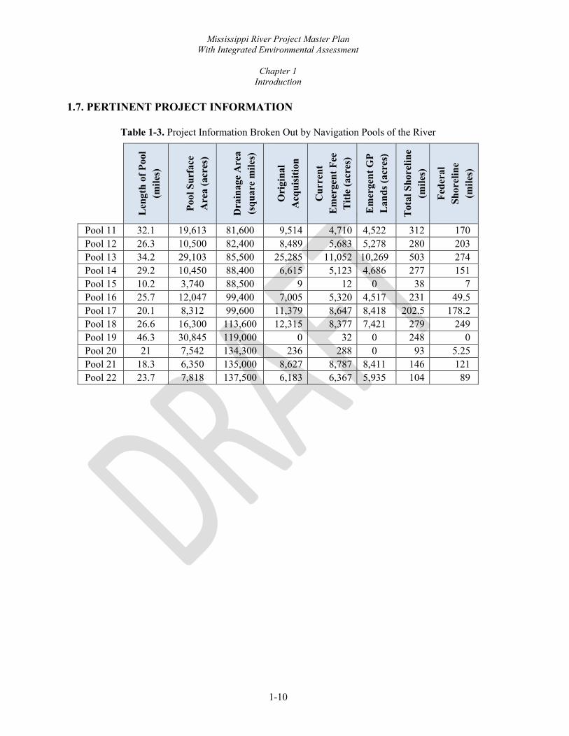
1.7. PERTINENT PROJECT INFORMATION
Table 1-3. Project Information Broken Out by Navigation Pools of the River
Len
gth
of P
ool
(mile
s)
Pool
Sur
face
A
rea
(acr
es)
Dra
inag
e A
rea
(squ
are
mile
s)
Ori
gina
l A
cqui
sitio
n
Cur
rent
E
mer
gent
Fee
T
itle
(acr
es)
Em
erge
nt G
P L
ands
(acr
es)
Tot
al S
hore
line
(mile
s)
Fede
ral
Shor
elin
e (m
iles)
Pool 11 32.1 19,613 81,600 9,514 4,710 4,522 312 170 Pool 12 26.3 10,500 82,400 8,489 5,683 5,278 280 203 Pool 13 34.2 29,103 85,500 25,285 11,052 10,269 503 274 Pool 14 29.2 10,450 88,400 6,615 5,123 4,686 277 151 Pool 15 10.2 3,740 88,500 9 12 0 38 7 Pool 16 25.7 12,047 99,400 7,005 5,320 4,517 231 49.5 Pool 17 20.1 8,312 99,600 11,379 8,647 8,418 202.5 178.2 Pool 18 26.6 16,300 113,600 12,315 8,377 7,421 279 249 Pool 19 46.3 30,845 119,000 0 32 0 248 0 Pool 20 21 7,542 134,300 236 288 0 93 5.25 Pool 21 18.3 6,350 135,000 8,627 8,787 8,411 146 121 Pool 22 23.7 7,818 137,500 6,183 6,367 5,935 104 89

2-1
CHAPTER 2
PROJECT SETTING, FACTORS INFLUENCING MANAGEMENT & DEVELOPMENT
(AFFECTED ENVIRONMENT) 2.1. INTRODUCTION
2.1.1. Public Lands. The U.S. Army Corps of Engineers (Corps), within the navigation impoundments of the Upper Mississippi River (UMR) Rock Island District (District), administers nearly 99,000 acres of public owned lands. These areas include islands, floodplain, and associated lands along the banks of the navigation pools. The U.S. Fish and Wildlife Service (USFWS), Iowa Department of Natural Resources (IA DNR), Illinois Department of Natural Resources (IL DNR), and Missouri Department of Conservation (MDC) partner with the District to manage significant portions of these lands for conservation, maintenance and management of fish and wildlife under General Plans (GP) and associated Cooperative Agreements (CA). Portions of additional lands are leased to other agencies, municipalities, and other entities for recreation and other uses.
Prior to and during construction of the Mississippi River Nine-Foot Channel Navigation Project (Project), the United States Government acquired fee title (Project lands) to approximately 93,600 acres of river lands as part of the Project. Since acquisition of land and establishment of the 9-foot channel, many physiographic changes have occurred along the river. The maps accompanying the MP (see Appendix J) reflect such changes and have been developed from the most accurate data available. Acreage figures, given in the following chapters, have been calculated from these maps for recreational and general land use planning only and should not be considered accurate for legal purposes. The USFWS manages three National Wildlife Refuges (NWR) along and within the Project including the Upper Mississippi River National Wildlife and Fish Refuge (in Pools 11-14; Port Louisa NWR in Pools 17 and 18; and Great River NWR in Pool 21. The IA DNR manages the Green Island Wildlife Management Area (WMA) in Pool 13, Princeton WMA in Pool 14, Odessa WMA in Pool 17, and other lands for wildlife management and recreation in Pools 11, 13, and 16-18. The IL DNR manages lands in Pools 13, 16-18, and 21-22. MDC manages lands including the Upper Mississippi Conservation Area in Pools 21-22 and Bay Island Conservation Area in Pool 22. 2.1.2. Public Waters. Navigational Servitude is defined by 33 CFR Ch. II, Part 329, as the “constitutional power given to the Federal government to regulate navigable waters” for the purposes of improving and regulating navigation. It includes submerged lands and water flowing over them and pertains to all lands below the ordinary high-water mark of a navigable river. Servitude is a concept of authority, not of property, and expresses the notion that the right of the public to use a waterway supersedes any claim of private ownership.

Mississippi River Project Master Plan With Integrated Environmental Assessment
Chapter 2
Project Setting, Factors Influencing Management & Development (Affected Environment)
2-2
2.1.3. Shoreline. Shoreline areas and islands under Federal fee ownership provide numerous recreational opportunities available on the navigation pools. This includes providing recreation areas managed by the Corps, other agencies, commercial concession, and other entities. Because the Project was constructed before December 13, 1974, it also includes allowances for privately owned recreational structures on Project lands in specified areas such as cottage area lease sites and Shoreline Management limited development areas. General information on Shoreline Management is included in Chapter 6, Special Topics, Planning Considerations, and Special Concerns. Although a separate document, the Shoreline Management Plan is related and complementary to this Master Plan.
2.1.4. Easements. Approximately 12,131 acres of mostly flowage easement along with some roadway easement rights were acquired by the Government during the original acquisition. More recently, the District has also acquired some easements for dredged material placement in limited locations. More details on easements are provided in Section 2.12.3.3, Flowage Easements, and Chapter 4, Land Allocation, Land Classification, Water Surface, and Project Easement Lands, of this document. 2.2. DESCRIPTION OF NAVIGATION POOLS The principal engineering feature of the Project is a system of locks and dams spaced at irregular intervals dependent on the slope of the river, the location of major population centers, and the navigation approach to the locks. Twelve locks and dams are located, operated, and maintained within the District. In addition, there are roughly 1,200 channel regulating structures, such as wing dams, that are also an integral part of the navigation infrastructure. The dams on the Project are single-purpose navigation dams built to provide 9-foot depths for river traffic at low water, except for Dam No. 19, which was built for electric power generation. The UMR navigation dams have movable gates with concrete gate sills on the bed of the river. During low flows, the movable gates are in the water and have only 2-3 foot openings between the bottom of the gates and the gate sill on the bed of the river. Dam No. 19, at Keokuk, was built by a private power company for power generation. Dam No. 19 is a high sill dam that utilizes lift gates which are opened to pass excess river flow at times when the flow exceeds the capacity of the electrical generating water turbines. The navigation dams, in general, are operated to maintain a constant pool elevation, or stage, at the dam or other designated location during low and medium-low flows. They are not designed for flood storage. Table 2-1 summarizes information for the twelve navigation pools under the management of Project. Within the District, the main locks have a clear chamber width of 110 feet and are 600 feet in length, except for Lock No. 19, located at Keokuk, IA, which has a clear width of 110 feet and a length of 1,200 feet. In addition, an auxiliary lock with a clear chamber width of 110

Mississippi River Project Master Plan With Integrated Environmental Assessment
Chapter 2
Project Setting, Factors Influencing Management & Development (Affected Environment)
2-3
feet and a length of 360 feet is located parallel and adjacent to the main lock at Lock No. 15. The LeClaire Lock was originally built as part of the 6-foot Channel Project and is now utilized as an auxiliary lock at Lock No. 14. Table 2-2 summarizes the Project navigation facilities and infrastructure.

Mississippi River Project Master Plan With Integrated Environmental Assessment
Chapter 2
Project Setting, Factors Influencing Management & Development (Affected Environment)
2-4
Table 2-1. Principal Features of the Navigation Pools 11-22 on the Mississippi River
Pool Length of Pool (mi)
Pool Surface Area (ac)
Drainage Area (sq mi)
Original Acquisition (ac)
Land (ac) 1
Total Shoreline (mi)
Federal Shoreline (mi)
Monumented Boundary (mi)
11 32.1 19,613 81,600 9,514 4,708 312 170 50.9 12 26.3 10,500 82,400 8,489 5,405 280 203 33.9 13 34.2 29,103 85,500 25,285 11,016 503 274 78.1 14 29.2 10,450 88,400 6,615 5,086 277 151 28.8 15 10.2 3,740 88,500 9 7.4 38 7 0 16 25.7 12,047 99,400 7,005 5,315 231 49.5 41.1 17 20.1 8,312 99,600 11,379 8,624 202.5 178.2 21.8 18 26.6 16,300 113,600 12,315 8,367 279 249 57.6 19 46.3 30,845 119,000 0 23 248 0 0 20 21 7,542 134,300 236 286 93 5.25 6.7 21 18.3 6,350 135,000 8,627 8,785 146 121 29.4 22 23.7 7,818 137,500 6,183 6,355 104 89 43.7
1 Includes emergent fee title acres and accreted lands only.

Mississippi River Project Master Plan With Integrated Environmental Assessment
Chapter 2
Project Setting, Factors Influencing Management & Development (Affected Environment)
2-5
Table 2-2. Principal Features of Locks and Dams 11 to 22 on the Mississippi River
Lock
Main Lock Chamber Dimensions
(width x length) Auxiliary
Lock Gate Dimension
(#,width x length) Gate
Type(s) Non-Overflow
Dike Overflow
Dike Year Placed in Operation
11 110’x600’ n/a 3 - 20’x100’ 13 - 20’x60’ Roller & Tainter 3,540’ None 1937
12 110’x600’ n/a 3 - 20’x100’ 7 - 20’x64’ Roller & Tainter 6,320’ 1,200 ft 1938
13 110’x600’ n/a 3 - 20’x100’ 10 - 20’x64’ Roller & Tainter 11,360’ 1,650 ft 1939
14 110’x600’ 80’x370’ 4 - 20’x100’ 13 - 20’x60’ Roller & Tainter 1,357’ None 1940
15 110’x600’ 100’x360’ 11 - 26’x100’ Roller None None 1934
16 110’x600’ n/a 4 - 20’x80’ 15 - 20’x40’ Roller & Tainter 1,141’ 1,700’ 1937
17 110’x600’ n/a 3 - 20’x100’ 8 - 20’x64’ Roller & Tainter 720’ 1,555’ 1939
18 110’x600’ n/a 3 - 20’x100’ 14 - 20’x60’ Roller & Tainter 3,470’ 2,200’ 1937
19 110’x1,200’ n/a Private structure Private structure None None 1913 - Private 1957 - Lock
20 110’x600’ n/a 3 - 20’x60’ 40 - 20’x40’ Roller & Tainter None None 1935
21 110’x600’ n/a 3 - 20’x100’ 10 - 20’x64’ Roller & Tainter 494 1,400 ft 1939
22 110’x600’ n/a 3 - 20’x100’ 10 - 20’x60’ Roller & Tainter 460 1,600 ft 1939

Mississippi River Project Master Plan With Integrated Environmental Assessment
Chapter 2
Project Setting, Factors Influencing Management & Development (Affected Environment)
2-6
2.3. RIVER HYDROLOGICAL CHARACTERISTICS
2.3.1. Pooled River. Early in the 20th century, Congress directed the Corps to design and construct a series of Locks and Dams to provide safe and efficient transportation via a dependable navigational channel. The locks and dams system has been operated successfully since the dams went into operation mostly around 1940. During low to moderate runoff periods, water flow is regulated by the locks and dams to maintain required navigation depth. From St. Anthony Falls, MN, to St. Louis, MO, the Mississippi resembles a downward staircase with each of the steps represented by a navigation pool. The locks which accompany the dams allow river traffic to “step” from pool to pool. Maintaining the minimum pool levels is a major responsibility of the Corps.
A portion of the land parcels purchased by the Federal government along the river are submerged (below normal pool levels) as a result of construction and operation of the navigation project. Erosion has also led to the reduction of some of the islands and riparian areas. The influence of water depths and fluctuation of those depths to the managed lands within navigation pools varies with distance upstream and downstream of the locks and dams. The greatest effect in water depth variance occurs directly below a lock and dam. As water levels rise, the head difference created by the dam equalizes and levels out, eliminating the “step” effect from pool to pool.
2.3.2. Mississippi River within the Project. The Upper Mississippi River (UMR) flows
314 miles through the District from Guttenberg, IA, river mile (RM) 14.0, to Saverton, MO, RM 300.5. The UMR has a series of channel training structures to help maintain a minimum 9-foot channel. These wingdams, side channel closing structures, and shoreline protection help maintain flow within the main channel of the river. The river follows a meandering course with wide, sweeping bends. The river is made up of numerous sloughs, side channels, and backwater areas outside of the main channel. The river varies greatly in width and is typically widest just upstream of the lock and dam, with lower Pool 13 measuring roughly 3 miles wide. The river also flows around hundreds of islands. This includes isolated small islands as well as major island complexes, some of which stretch 7 miles long or more.
2.3.3. Annual River Discharge. The long-term average annual hydrologic pattern on the UMRS is one of high river flows in the spring, low summer flow, increased flow in fall, and a low flow in the winter. On average, the Mississippi River at Rock Island (Lock and Dam 15) shows the highest mean discharges in April and May and the lowest discharge in December and January. Variations in precipitation, topography, regulation, flood control works, and land use practices cause fluctuations in discharge. River discharges increase as one proceeds further downstream.
The Corps’ Upper Mississippi River and Illinois Waterway Cumulative Effects Study documented increases in frequency and amplitude of flooding, especially since 1950. The mean annual discharge and annual minimum flow have been trending upward over time as

Mississippi River Project Master Plan With Integrated Environmental Assessment
Chapter 2
Project Setting, Factors Influencing Management & Development (Affected Environment)
2-7
well (Corps, 2000). The maximum annual recorded discharge rates of the river near Clinton, Iowa and Lock and Dam 13 can range from 50,000 to over 250,000 cubic feet per second (cfs), while the minimum annual recorded discharge is typically below 20,000 cfs. The river at Keokuk, IA, can see maximum annual recorded discharge rates from 100,000 to over 300,000 cfs with minimum annual recorded discharge rates below 30,000 cfs. This trend can be seen in more frequent flooding as shown by flood crest data from the National Weather Service at Lock and Dam 22 near Hannibal, MO, in Figure 2-1. The Cumulative Effects Study can be referenced for more detailed information on river discharge rates.
Figure 2-1. Number of Top 100 Flood Crests by Decade since 1900 at Hannibal, MO (NWS, 2019) The river discharges and resulting flooding is a large driver for the type of vegetation found on Project lands. Nearly 94,000 acres of the Project’s 98,858 total acreage (submerged and emergent lands) are considered wetland according to the National Wetland Inventory (USFWS, 2019). This is in large part due to the frequency of flooding. The resulting land cover types in terrestrial areas are those that are frequently flooded (floodplain forest, mudflats, sandbars, etc.) or are submerged (open water, marsh, etc.). See Figure 2-2. Floodplain forests can endure brief inundation, but prolonged inundation, such as the Great Flood of 1993, can have devastating effects on the forest community. That flood caused significant mortality of trees especially with stems under 4 inches in diameter (USGS 1999). More diverse tree species such as oak and hickory species are expected to decline and reduce in coverage due to being less tolerant of flooding and extended soil saturation (Corps, 2012).
0
5
10
15
20
25
30
1900 1920 1920 1930 1940 1950 1960 1970 1980 1990 2000 2010
Number of Top 100 Flood Crests by Decade Since 1900 at Lock and Dam 22
Crests by Decade
- I I I I - I - I I I ■

Mississippi River Project Master Plan With Integrated Environmental Assessment
Chapter 2
Project Setting, Factors Influencing Management & Development (Affected Environment)
2-8
Figure 2-2. Project Land Cover Types Subject to Flooding (USGS, 2011)
Flooding also has direct impacts to recreation areas. In 2019, Corps-managed campsites available for reservation through the Recreation One Stop (R1S) system totaled 392 sites over 6 campgrounds. R1S is an interagency partnership among Federal agencies to provide reservation services, sharable data, and recreation trip-planning tools for Federal lands and waters across the United States. Flood events in 2019 caused the R1S campgrounds to be closed/affected resulting in a 34% loss of campsite availability during the recreation season due to flooding. In addition to natural resources, flooding also requires consideration for development of lands. The majority of Project lands lie within the Base Flood Plain. Per Engineering Regulation (ER) 1165-2-26, a Base Flood is that flood which has a one percent chance of occurrence in any given year (also known as a 100-year flood). A Base Flood Plain is the one percent chance flood plain. Executive Order (EO) 11988, Floodplain Management, requires Federal agencies to recognize the significant values of floodplains and to consider the public benefits that would be realized from restoring and preserving floodplains. Under EO 11988 and Engineer Regulation 1165-2-26, Implementation of Executive Order 11988 on Floodplain Management, the Corps provides leadership and acts to:
• Avoid development in the base flood plain unless it is the only practicable alternative;
• Reduce the hazard and risk associated with floods;
• Minimize the impact of floods on human safety, health, and welfare; and
Open Water35%
Frequent Flooding62%
Infrequent Flooding3%

Mississippi River Project Master Plan With Integrated Environmental Assessment
Chapter 2
Project Setting, Factors Influencing Management & Development (Affected Environment)
2-9
• Restore and preserve the natural and beneficial values of the Base Flood Plain. Executive Order 11988 and ER 1165-2-26 are considered for any development within the Base Flood Plain on Project lands. 2.4. SEDIMENTATION & SHORELINE EROSION Erosion and sedimentation are natural processes within the river system. Due to human development within the floodplain over the last 200 years, the erosion process has accelerated, increasing the sediment load of the river and the turbidity of the water. Human influences including land use, navigational structures, dredging, flood control, and other items can affect geomorphic processes. Over the last 60 years, the Natural Resource Conservation Service (NRCS), the Corps, and other agency partners have been working to reduce these processes. Some success in sediment reduction has become apparent, particularly in the past 25 years, but more effort is needed to further control this problem. The Upper Mississippi River and Illinois Waterway Cumulative Effects Study provided a comprehensive review and future projections of geomorphological changes including the following: sedimentation, shoreline erosion, loss of contiguous backwaters, filling of isolated backwaters, loss of secondary channels, filling between wing dams, wind-wave erosion of islands, island dissections, tributary delta formation, delta formation, and island formation (Corps, 2000). Field surveys covered RMs 0 to 854 along the UMR, and 43 sites on the UMR were investigated. The study concluded that 14% of the UMR banks are actively eroding (Corps, 1997). Flood flows were found to be the dominant cause for bank erosion. Additional causes include direct barge impact, propeller wash, barge cabling to trees, and wave-induced erosion (Corps, 1997). Upland erosion and the sedimentation in downstream areas are major causes of reduced water quality and habitat destruction in most mid-western rivers and streams. Sedimentation in the backwaters of the UMR is a significant environmental problem. The depth diversity in the impounded areas has been reduced since construction of the dams especially in non-channel backwater areas (UMESC, 2008). According to the United States Geological Survey (USGS): “In all reaches, sedimentation has filled-in many backwaters, channels, and deep holes. In the lower reaches (St. Louis District), sediments have filled the area between many wing dikes producing a narrower channel and new terrestrial habitat. Erosion has eliminated many islands, especially in impounded zones. Although annual rates of sedimentation and erosion were highly variable, the net effect over 50 years was a substantial loss of habitat diversity. We expect sediment inputs to the system to remain high and expect both filling and erosion to continue, but at slower rates.” (USGS, 2008)

Mississippi River Project Master Plan With Integrated Environmental Assessment
Chapter 2
Project Setting, Factors Influencing Management & Development (Affected Environment)
2-10
This sedimentation has not only affected the ecological resources of the Project but has also affected recreation. Some recreation areas, including those that are Corps-managed and those managed by Corps partners, have reduced boating access due to sedimentation. Where erosion affects Project features or resources such as impacting the 9-foot channel or a cultural site, it is within the Project’s mission to address the erosion. The placement of rip rap or other bank line protection is contingent on availability of funding and compliance with applicable policies, regulations, and laws. Given limited funding and the large extent of bank lines, the Project is unable to fund or complete bank line protection outside of those areas impacting Project missions such as navigation. 2.5. WATER QUALITY The UMR’s enormous scale, complexity, and diversity, as well as basin-wide influences and system modifications, present numerous challenges in water quality management. Each state implements the Clean Water Act (CWA) independently on the UMR. Each state in the District has the Mississippi River listed on the 303d list of Impaired Water Bodies (USEPA, 2019). While there are many commonalities among the states in their CWA implementation on the UMR, there are also significant differences in designated uses, water quality criteria, monitoring, assessment methodologies and impairment listings (UMRBA, 2012). Figure 2-3 compiles the states’ CWA 303d impairment listings from 2008, demonstrating the complexity of water quality analysis on the UMR. Common impairment pollutants are fecal coliform, polychlorinated biphenyls, mercury, and total phosphorous. Pollutants enter the system through various means such as non-point source pollution, point source pollution, and, to a lesser extent, environmental spills. Low water clarity and short-term variation in water levels are found to be the primary factors limiting distribution of submersed vegetation. Total nitrogen concentrations exceed suggested guidelines on monitored pools including Pool 13 about 50% of the time and Pool 26 about 90% of the time during the study period (USGS, 2008).

Mississippi River Project Master Plan With Integrated Environmental Assessment
Chapter 2
Project Setting, Factors Influencing Management & Development (Affected Environment)
2-11
Figure 2-3. The 303d List of Impaired Water Bodies as of 2008
Iowa
~
~' Wisconsin La, Crosse ..
..--...--· .....
f
'
DubtJque
--1· ~
- - --Keokuk
11rnois --•'ft'• •*· . (
Missouri
2008 UMR Impairments
- Dri11ki1ng Water
- Aquauc Recreatilo:n
Aquauc Life
FIS!, ,consumption
- Ye11
•• • TMCL
R.uc:h Boundarin,
.. .. • -- I -.. •

Mississippi River Project Master Plan With Integrated Environmental Assessment
Chapter 2
Project Setting, Factors Influencing Management & Development (Affected Environment)
2-12
2.5.1. Non-Point Source Pollution. Runoff from agricultural fields and urban landscapes is the major contributor of non-point source pollution into the Mississippi River and its tributaries. Another significant source of non-point source pollution is the erosion of hillsides, gullies, stream banks, and islands. Erosion introduces tremendous amounts of sediment, nitrates, phosphorus, and other chemicals into the system, negatively affecting water clarity, increasing turbidity, and decreasing dissolved oxygen (DO) levels. Increased nutrient pollution also promotes the growth of algae (USEPA, 1998). Algal blooms have been known to threaten aquatic ecosystem sustainability and decrease recreation potential (Hudnell, 2010, Ribaudo et. al., 2001). Nitrogen and phosphorus are limited nutrients in a natural ecosystem and applied fertilizers that contain these nutrients often drain into waterways and tributaries during precipitation events, ultimately flowing into the Mississippi. Some of these and other chemicals settle out and are incorporated into the bottom substrate. Many of the chemicals join the water column and course down the Mississippi to the Gulf of Mexico. Currently, non-point source pollution is a factor linked to the Gulf of Mexico’s “dead zone” (Dodds, 2006).
2.5.2. Point Source Pollution. The water quality of the Mississippi River is of paramount importance when it comes to sustaining the many uses of the river, including drinking water and recreational and commercial activities. The Clean Water Act, passed by Congress in 1972, is the cornerstone of surface water quality protection in the United States, employing regulatory and non-regulatory measures designed to reduce direct pollutant discharges into waterways. The Clean Water Act has reduced much pollution in the Mississippi River from “point sources” such as industries and water treatment plants, but problems stemming from urban runoff, agriculture, and other “non-point sources” have proven more difficult to address.” (NRC, 2008) Planning or regulating point source pollution is outside of the scope of this MP. Each of the UMR states and Environmental Protection Agency are involved in regulating point source pollution. The UMR Basin Association (UMRBA, 1993) and other organizations such as the McKnight Foundation (NRC, 2008) have also taken steps to address point source pollution affecting the river.
2.5.3. Environmental Spills. Many potential sources of spills exist throughout the
UMRS, including highway and railroad crossings, pipelines, municipal and industrial plants, barge traffic, and terminals. Potential spill sources are discussed in detail in the Upper Mississippi River Spill Response Plan and Resource Manual (UMRBA, 2014). In addition, it describes resources available for responding to a spill. Hazardous material with the highest bulk movement and thus highest probability for a spill are chemicals, chemical products, fertilizer, petroleum products, and coke petroleum pitches. The UMRBA is currently in the process to update spill plans on several pools. 2.6. CLIMATE & WEATHER The Project is located at approximately Latitude 39 to 42.5 degrees North and Longitude -90 to -91 degrees East. The topographic relief within the region has limited influence on climatic conditions. Continental climatic conditions prevail in the Project because of its latitudinal and

Mississippi River Project Master Plan With Integrated Environmental Assessment
Chapter 2
Project Setting, Factors Influencing Management & Development (Affected Environment)
2-13
interior location. The region has four distinct seasons without the undue hardships of prolonged periods of extreme high or low temperatures (Table 2-3 and Figure 2-4).
Table 2-3. Climate Averages at Quincy, Rock Island, and Dubuque, 1981-2010
Quincy, IL Rock Island, IL Dubuque, IA Average High Temperature 63.1 F 60.6 F 56.4 F Average Low Temperature 43.8 F 43.4 F 38 F Average Temperature 53.45 F 52 F 47.2 F Average Annual Precipitation 36.74 in 37.02 in 36.33 in
Figure 2-4. Average Monthly Temperatures and Precipitation for Rock Island, IL, from 1981-2010
As shown in Figure 2-5, the average yearly temperature has increased across the Midwest over the last 100 years by almost 1.5° Fahrenheit. Extreme rainfall events and flooding have increased during the last one hundred years, and appear poised to continue, causing erosion, declining water quality, and negative impacts on transportation, agriculture, human health, and infrastructure. The range and distribution of fish and other aquatic species will likely change, and an increase in invasive species would also likely occur (Pryor et al., 2014).
0
1
2
3
4
5
6
0
10
20
30
40
50
60
70
80
90
Jan Feb Mar Apr May Jun Jul Aug Sep Oct Nov Dec
Aver
age
Prec
ipia
tion
(in)
Aver
age
Tem
pera
ture
(F)
Average Precipitation (in) Average High (°F) Average Low (°F)-

Mississippi River Project Master Plan With Integrated Environmental Assessment
Chapter 2
Project Setting, Factors Influencing Management & Development (Affected Environment)
2-14
Figure 2-5. Temperatures Rising in the Midwest
Annual average temperatures (red line) across the Midwest show a trend towards increasing temperature. The trend (heavy black line) calculated over the period 1895-2012 is equal to an increase
of 1.5°F. (Figure source: updated from Kunkel et al. 2013) 2.7. TOPOGRAPHY, GEOLOGY, AND SOILS
2.7.1. Geology and Topography. There were four main events in the geologic history of the Project area, which account for the bedrock distribution, structural features, and the surface materials found in the uplands and alluvial valleys.
• Sedimentary rock units, some 4,000 to 5,000 feet thick, were deposited over Precambrian Era extrusive and intrusive igneous rocks by alternate inundation and regression of semitropical or tropical seas. The marine phases were the most persistent.
• Beginning during the Pleistocene Epoch or Ice Age, about 1 million years ago, great continental ice sheets moved into the mid-latitudes of the United States, and the Midwest was overrun by a series of glacial phases known as the Nebraskan, Kansan, Illinoian, and Wisconsinan glaciers. The last glacial phase, the Wisconsinan, receded approximately 12,000 years ago. These glaciers
..--.. 5 u. 0 -Q) 4 C) ro '-Q) 3 ~ E e 2 -~ 1 C Q)
0 '-
im i5 -1 ~ ::::,
-2 -ro '-Q) 0. -3 E ~ -4
1900 1920 1940 1960 1980 2000 Year

Mississippi River Project Master Plan With Integrated Environmental Assessment
Chapter 2
Project Setting, Factors Influencing Management & Development (Affected Environment)
2-15
deposited drift on the uplands and filled the alluvial valleys with outwash (Schoewe, 1923).
• During and after the Wisconsinan Period, dry winds dominantly from the west blew across exposed glacial outwash in the Mississippi, Illinois, and Kaskaskia valleys. This lighter weight material was carried eastward and deposited loess on the upland part of the region. Loess is the parent material for most of the present soils on the upland part of the region (Schoewe, 1923).
• During the Holocene Stage (recent) the upland surface has been eroded and modern soils created. The age of the surficial bedrock is Ordovician to Cretaceous and is overlain with a mantle of younger Pleistocene and Holocene drift and soils. In the alluvial valleys, some of the valley fill has been scoured away and subsequent river changes and flooding have created the present-day floodplain morphology and alluvial soils.
2.7.2. Topography. According to the USGS, “the Upper Mississippi River System
(UMRS), the navigable part of the Upper Mississippi and Illinois Rivers, is a diverse ecosystem that contains river channels, tributaries, shallow-water wetlands, backwater lakes, and flood-plain forests. Approximately 10,000 years of geologic and hydrographic history exist within the UMRS. Because it maintains crucial wildlife and fish habitats, the dynamic ecosystems of the Upper Mississippi River Basin and its tributaries are contingent on the adjacent flood plains and water-level fluctuations of the Mississippi River” (Stone et al., 2017). The river meanders through the valley surrounded by scenic hills, bluffs, and floodplains. Much of the floodplain area consists of fertile alluvial deposits fringed by a natural levee. Common landforms found on Project lands include glacial terraces, active floodplains, natural levees, slopes, islands, channels, and backwaters. The floodplain in the upper pools of the project are restricted by narrow valley walls and typically extends laterally to railroad track embankments at the base of the bluffs. Downstream of Pool 16, the floodplain broadens out and typically has levees along or just outside Project lands for flood protection of the remainder of the floodplain, for farming and developed areas. 2.7.3. Soils. Soils of the project lands are, generally, first bottom soils originating from alluvial deposits and almost all are subject to inundation during periods of high water. However, the Farmland Protection Policy Act (FPPA) requires an evaluation of any prime or unique soils and is intended to minimize the impact Federal programs have on the unnecessary and irreversible conversion of farmland to nonagricultural uses. For the purpose of FPPA, farmland includes prime farmland, unique farmland, and land of statewide or local importance. In general, prime and/or unique farmland has an adequate and dependable supply

Mississippi River Project Master Plan With Integrated Environmental Assessment
Chapter 2
Project Setting, Factors Influencing Management & Development (Affected Environment)
2-16
of moisture from precipitation or irrigation, a favorable temperature and growing season, acceptable acidity or alkalinity, an acceptable salt and sodium content, and few or no rocks (NRCS, 2021). While most soils within the project area are not considered farmland due to their sand content and proclivity to flooding, prime and unique soils do exist within the Project. Soil resources on the Project are classified into two broad groups, riverwash and alluvial. Stability of the land and frequency of overflow are the major criteria in distinguishing between these groups. Areas formed from recent deposits of fine and coarse water-borne materials are classified as riverwash and cannot be regarded as true soil because of the heterogeneous mixture of materials. In some locations, sand bars are formed, and mudflats develop in others. Such areas are very unstable and high water may change or completely remove the existing deposits.
Although distinct soil types exist, this general classification is considered adequate for the purpose of the Plan. Varying more in their capabilities than the riverwash type, some alluvial soils are low in fertility while others can support a wide variety of vegetation. More stable than riverwash soils and less susceptible to overflow, such soils vary in texture and drainage. However, the susceptibility to overflow overrides the properties limiting their true potentials. Soils of this type support considerable native vegetative growth and generally are suitable for development as public recreational sites. Soils on Project land are generally classified as a mixed composition of silt, clay and/or loam ranging from excessively drained to very poorly drained – a majority of soils are considered poorly drained. Dominant soils within the Project consist of Entisols such as Fluvaquents and sandy Aquents. Other dominant soils include Caneek silt loam, Nodaway-Kulm Perks complex, Blake-Slacwater silt loam, and Bird silt loam. A detailed soil survey is prepared by the US Department of Agriculture, NRCS through the Web Soil Survey at the county level (USDA-NRCS, 2017). The Soil Survey identifies soil type and characteristics regarding recreational development, engineering, and natural resource conservation practices based off specific soil units. This survey will be referenced for developing specific resource management plans. The Soil Survey was queried for Soil Capability Class for the Plan (Table 2-4). This data is typically used in context of the capability for farming but can be looked at as one metric to review potential for management or development. This analysis indicates most Project lands may have limitations of use.

Mississippi River Project Master Plan With Integrated Environmental Assessment
Chapter 2
Project Setting, Factors Influencing Management & Development (Affected Environment)
2-17
Table 2-4. Level One Inventory of Non-Irrigated Soil Capability Class Acreages on Mississippi River Project Lands 1
Pool Class I Class II Class III Class IV Class V Class VI Class VII Class VIII 11 0.9 286.0 819.1 43.9 1,220.7 6.5 1,883.3 0 12 0 1,206.3 317.0 31.1 2,736.2 7.0 338.4 3,722.8 13 395.2 415.3 1,172.6 193.4 5,641.9 45.7 154.4 10,611.6 14 23.7 389.9 2,224.4 11.8 2,108.4 14.6 0.6 964.8 15 0.6 6.6 0 0 0 0 0 2.3 16 1.3 808.7 499.6 0 3,924.8 0 12.8 1,786.9 17 0 1,652.1 318.0 175.1 5,432.7 15.4 16.4 1,654.0 18 1.0 220.3 186.3 97.5 7,491.0 109.7 41.1 1,782.4 19 0 0.8 0 0 16.1 0 0.2 9.7 20 0 117.7 144.1 0 10.4 0 0 73.2 21 0 421.5 444.0 0.3 7,731.6 0 0 962.2 22 0.6 1,007.9 1,195.1 1,032.9 3,042.9 0 7.6 849.2
Total 423.4 6,533.1 7,320.3 1,585.9 39,356.6 198.8 2,455.0 22,418.9 1 Soil Class Definitions: Class I soils have few limitations that restrict their use. Class II soils have moderate limitations that reduce the choice of plants or that require moderate conservation practices. Class III soils have severe limitations that reduce the choice of plants or that require special conservation practices, or both. Class IV soils have very severe limitations that reduce the choice of plants or that require very careful management, or both. Class V soils are not likely to erode but have other limitations, impractical to remove, that limit their use. Class VI soils have severe limitations that make them generally unsuitable for cultivation. Class VII soils have very severe limitations that make them unsuitable for cultivation. Class VIII soils and miscellaneous areas have limitations that nearly preclude their use for commercial crop production.

Mississippi River Project Master Plan With Integrated Environmental Assessment
Chapter 2
Project Setting, Factors Influencing Management & Development (Affected Environment)
2-18
Management of project soils will be affected indirectly through management of forest, wildlife, and recreational resources. Susceptibility to overflow and change resulting thereby, limited access, and relatively small areas make a management program impractical for the soils resource exclusively. 2.8. RESOURCE ANALYSIS (Level One and Two Inventories) Under the Environmental Stewardship program, the Corps is responsible for the management, conservation, and protection of natural resources for sustained use by future generations. Natural resource inventories are required on Project lands and waters to provide quantitative and qualitative data for use in determining resource management needs. There are two types of inventories: Level One and Level Two. The Level One inventories are general in nature and are conducted to provide baseline plant and animal information. Inventories are conducted to determine acreage of dominant vegetative types, wetlands, soil types, land use capabilities, and presence of special status species and their critical habitat occurring on Project lands and waters. A Level One inventory was completed using available information from a variety of sources, such as USGS maps (USGS, 2011), county soil surveys, USFWS information (USFWS 2017), aerial photography, Corps real estate maps, project planning and design memorandums, and state DNR resource information in 2011. Level One inventories are spatially georeferenced and viewed digitally through platforms such as ArcGIS; individual Level One inventories create a layer viewed through geographic information system (GIS) platforms. Layers are overlaid and correlated from past and present data to derive determined community types, updating managed land classifications, documentation of multiple resource types, and updating acreages of managed Federal lands within project boundaries to support decisions to baseline considerations. The Level Two inventories are prepared in support of the resource objectives and/or land use classifications and are generally more detailed or specific. These inventories are required for the effective development, execution, and evaluation of specific natural resources management prescriptions. The Project has conducted inventories for forest habitat, wetland habitat, and some endangered species. Level Two inventories for endangered species and habitat still require information collection to update to current conditions as required for decision making needs. Completion of these inventories are a funding priority as they are critically needed to protect and sustain habitats, fish, wildlife and endangered species and other stewardship opportunities.
2.8.1. Fish & Wildlife Resources. The UMRS, of which the Project is a part, is a nationally and internationally significant ecosystem, supporting more than 30 federally listed or candidate threatened and endangered species (USFWS, 2017). The UMRS supports 156 species of fish, 40 percent of North America’s migratory waterfowl, and 60 percent of all bird species in North America (Corps, 2004). The Upper Mississippi River National Wildlife and Fish Refuge (NWFR), a portion of which is in Pools 11-14, supports 51 species of mammals

Mississippi River Project Master Plan With Integrated Environmental Assessment
Chapter 2
Project Setting, Factors Influencing Management & Development (Affected Environment)
2-19
and 42 species of mussels (USFWS, 2006). More than 200 species of birds are found within the 210,000 acres of Corps-managed land along the UMR (Dinsmore, 2016). In 1986, Congress designated the Mississippi River “...as a nationally significant ecosystem and a nationally significant commercial navigation system.” The Mississippi River is the only river with such designation. (Public Law 99-662, 1986)
2.8.1.1. Important Bird Areas and Habitats. The UMR provides a network of aquatic and terrestrial habitats that are crucial for bird species that utilize the Mississippi Flyway during spring and fall migrations. The Project is one of over 500 Globally Important Bird Areas in the US as designated by the American Bird Conservancy through their Important Bird Area (IBA) program in 2001. The Upper Mississippi River NWFR, Port Louisa National NWR, Great River NWR, and Two Rivers NWR are all recognized as Globally Important Bird Areas by The Audubon Society. The initial goal of the IBA program is to recognize sites that have high value to bird conservation.
Colonial-nesting birds, waterfowl, and neo-tropical migrants all depend on the UMR corridor and its diverse habitat types. Most of the area within the UMR floodplain is wetland or converted wetland. Wetlands provide habitat for nearly 33% of migrating waterfowl and federally listed species (USFWS, 2015).
2.8.1.2. Colonial-Nesting Birds. Mature forested floodplains encompass habitat
types in the UMR that are important to colonial-nesting birds. Habitat types include wetlands, wet meadow, and backwaters. The diverse terrestrial and aquatic areas provide suitable resting, feeding, and nesting grounds for these colonial birds. Species observed include great blue herons (Ardea herodias), great egrets (Ardea alba) and double-crested cormorants (Phalacrocorax auritus). In recent years, cattle egrets (Bubulcus ibis) have begun nesting in trees on islands in Pool 13 and over 4,000 active great blue heron nests have been recorded in approximately 14 colonies on the Upper Mississippi River NWFR. However, nationwide populations of great blue herons and great egrets are declining due to habitat loss and degradation, supporting the importance of protecting these areas for the colonial birds (Custer & Galli, 2002).
2.8.1.3. Waterfowl. The UMR supports hundreds of thousands of migrating
waterfowl for weeks during spring and fall, as they stop to rest and feed. Wetland habitats have been noted to be especially important for juvenile birds in the fall during migration. An estimated 40 percent of the world’s canvasback ducks (Aythya valisineria) and over 20 percent of the eastern North American population of tundra swans (Cygnus columbianus) use the UMR (USFWS, 2019). Some sample migration peak waterfowl counts (from 2006) and approximate percentages of populations are as follows: eastern North American population of tundra swans - 52,070 (50%); canvasback - 250,280 (25%). Within the UMR, the large, deep open pools of the river created by dams are vital to canvasbacks, a Priority Resource of Concern for the USFWS (USFWS, 2019).

Mississippi River Project Master Plan With Integrated Environmental Assessment
Chapter 2
Project Setting, Factors Influencing Management & Development (Affected Environment)
2-20
Additional waterfowl species that represent USFWS’s Refuge Resources of Concern include mallards (Anas platyrhynchos) and wood ducks (Aix sponsa). Mallards typically nest on islands or in grasslands adjacent to the river, while wood ducks nest in tree cavities in the forests. In the early 1900s, wood ducks were nearly extirpated due to over-hunting and habitat loss. Today, waterfowl breeding area surveys and hunter harvest data provide a framework for detecting overall population trends in order to set appropriate bag limits, ensuring the survival of the species. Approximately 40 percent of the continent’s waterfowl use the UMR and nearly 60 percent of waterfowl hunting in the U.S. occurs within USFWS management areas that border the Mississippi Flyway (USGS, 1999). Although waterfowl remain abundant, their numbers have declined since the 1950s due to habitat alteration, habitat loss, and pollution.
2.8.1.4. Neo-tropical Migrants. The Project also provides extensive forested
floodplain corridor, supplying critical habitat for migrating neo-tropical songbirds, as well as nesting and feeding areas for resident land bird species. Neo-tropical migrants that represent Resources of Concern across UMR Refuges include the cerulean warbler (Setophaga cerulea), prothonotary warbler (Protonotaria citrea), yellow-billed cuckoo (Coccyzus americanus), and Bell’s vireo (Vireo bellii) (USFWS, 2019). Year-around resident species include pileated woodpecker (Dryocupus pileatus), great horned owl (Bubo virginianus), and black-capped chickadee (Poecile atricapillus). The previously listed birds are insectivores, predators, and seed dispersers, all of which have an important ecological function in riparian communities.
The Cerulean Warbler (Setophaga cerulea) is an indicator species, or a species which is representative of environmental health within its habitat (Laaker, 2018). Habitat requirements for the cerulean warbler are large, mature tracts of bottomland forests with horizontal and vertical diversity (USFWS, 2012). The presence of rare species like the cerulean warbler lets natural resource managers know that current management practices are having a positive impact on the landscape and are providing habitat that supports a diverse community of species.
2.8.1.5. Species of Conservation Concern. The USFWS’ website, Information
for Planning and Conservation, listed 32 migratory bird species of conservation concern and has the highest priority for conservation that may use the Project area sometime during their nesting or migration seasons (Table 2-5).

Mississippi River Project Master Plan With Integrated Environmental Assessment
Chapter 2
Project Setting, Factors Influencing Management & Development (Affected Environment)
2-21
Table 2-5. Migratory Birds of Conservation Concern1
Species Scientific Name Season Acadian Flycatcher Empidonax virescens Breeding Black Tern Chlidonias niger Breeding Bobolink Dolichonyx oryzivorus Breeding Cerulean Warbler Dendroica cerulea Breeding Least Bittern Ixobrychus exilis Breeding Marsh Wren Cistothorus palustris Breeding Mississippi Kite Ictinia mississippiensis Breeding Rusty Blackbird Euphagus carolinus Wintering Wood Thrush Hylocichla mustelina Breeding Worm Eating Warbler Helmitheros vermivorum Breeding Brown Thrasher Toxostoma rufum Breeding Black-billed Cuckoo Coccyzus erythropthalmus Breeding American Bittern Botaurus lentiginosus Breeding Northern Flicker Colaptes auratus Year-round Black-crowned Night-heron Nycticorax nycticorax Breeding Field Sparrow Spizella pusilla Breeding Pied-billed Grebe Podilymbus podiceps Breeding Blue-winged Warbler Vermivora pinus Breeding Dickcissel Spiza Americana Breeding Henslow’s Sparrow Ammodramus henslowii Breeding Kentucky Warbler Oporornis formosus Breeding Prothonotary Warbler Protonotaria citrea Breeding Fox Sparrow Passerella iliaca Wintering Upland Sandpiper Bartramia longicauda Breeding Red-headed Woodpecker Melanerpes
Year-round
Bald Eagle Haliaeetus leucocephalus Year-round Bell’s Vireo Vireo bellii Breeding Loggerhead Shrike Lanius ludovicianus Year-round Peregrine Falcon Falco peregrinus Breeding Short-eared Owl Asio flammeus Wintering Swainson’s Hawk Buteo swainsoni Breeding Willow Flycatcher Empidonax traillii Breeding
1Species table produced using USFWS IPaC, accessed March 2, 2021
2.8.1.6. Mammals. An abundance of mammals inhabit the river’s floodplain forests and islands of the Project, such as: white-tailed deer (Odocoileus virginianus), red fox (Vulpes vulpes), coyote (Canis latrans), bobcat (Lynx rufus), squirrels (Sciuridae sp.), raccoon (Procyon lotor), muskrat (Ondatra zibethicus) and beaver (Castor canadensis). According to the UMR Systemic Forest Stewardship Plan (Corps, 2012) most mammal

Mississippi River Project Master Plan With Integrated Environmental Assessment
Chapter 2
Project Setting, Factors Influencing Management & Development (Affected Environment)
2-22
populations within the river corridor are considered abundant and healthy. However, some bat species are experiencing population declines due to habitat loss and disease (Pettit & O’Keefe, 2017).
Due to diverse ecological requirements, bats are susceptible to environmental changes which result in population declines. Throughout the Project’s region, bats use multiple types of land cover categories for specific life characteristics. Habitats within the floodplain forests and bottomland forests provide critical resources for tree-roosting bats in particular (Medlin et al., 2008). Several species of bats rely on the floodplain forest as a migratory corridor, a high-quality food source (insects), and as quality habitat produced by snag trees for roosting. Bat species also use caves and rock crevices along UMRS for hibernation (USFWS, 2018). Tree roosting bat species, as well as the bottomland forest habitat they require, are considered Priority Resources of Concern for the Upper Mississippi River NWFR (USFWS, 2019). A bat species of particular concern is the Indiana bat (Myotis sodalis). The Indiana bat is listed as Endangered by USFWS through the Endangered Species Act (ESA) (Carter & Feldhamer, 2005). Its population has declined drastically over the last 50 years due to loss of mature forest and the arrival of the fungal disease White Nose Syndrome. To combat these declines, protecting or creating habitat is strongly considered when management projects are within listed species’ known population range. Table 2-6 represents the bats inhabiting floodplain forests in the UMRS.

Mississippi River Project Master Plan With Integrated Environmental Assessment
Chapter 2
Project Setting, Factors Influencing Management & Development (Affected Environment)
2-23
Table 2-6. Upper Mississippi River Bat Species List (USFWS, 2018)
Common Name
Species (Scientific Name)
Federal (T or E)
Iowa (T or E)
Illinois (T or E)
Missouri (T or E)
Wisconsin (T or E)
Big Brown Bat Eptescius fuscus T Evening Bat Nycticeius humeralis Gray Bat Myotis grisescens E E E Hoary Bat Lasiurus cinerus Indiana Bat Myotis sodalis E E E E Northern Long-Eared
Myotis septentrionalis T T E T
Little Brown Bat Myotis lucifugus T Eastern Red Bat Lasiurus borealis Silver-haired Bat Lasionycteris noctivagans Tricolored Bat Pipistrellus subflavus T

Mississippi River Project Master Plan With Integrated Environmental Assessment
Chapter 2
Project Setting, Factors Influencing Management & Development (Affected Environment)
2-24
2.8.1.7. Fish & Mussels. The Mississippi River is home to over 150 species of fish. This important fishery serves both commercial as well as recreational harvest, providing an estimated $1.2 billion economic benefit. Threats facing this fishery included loss of quality habitats, pollution, intense land use practices, and navigation requirements (USFWS, 2011). River stretches with a variety of geomorphological characteristics host various water flows, substrate compositions, and biotic components. Due to this habitat heterogeneity, there is a diverse array of fish that persist in defined geographic areas (USFWS, 2011). The construction of the lock and dam system on the UMR created impounded areas of the river, slowing it down and increasing silt deposition. Initially, this created backwaters and side channel habitats which benefited Refuge Resources of Concern like the largemouth bass (Micropterus salmoides), bluegill (Lepomis macrochirus), and crappie (Pomoxis annularis) that prefer still water. Some of these areas have now become silted in and are no longer considered ideal habitat for these centrarchid fish species. However, there is a focus on improving backwater habitats through increasing depths and providing aquatic vegetation as a part of on-going UMRR-HREP. Riverine and sediment-tolerant species like the channel catfish (Ictalurus punctatus), buffalo carp (Ictiobus cyprinellus), freshwater drum (Aplodinotus grunniens), and shovelnose sturgeon (Scaphirhynchus platorynchus) still predominate in areas with current such as the main channel and main channel border. Historically, 51 species of mussels have been documented as native in the UMRS, but only 44 species have been documented in surveys conducted within the past 35 years (USGS, 2000). These 44 species inhabit a variety of aquatic habitats. As filter feeders, mussel species are often used by natural resource managers as indicators of aquatic ecosystem health. Any toxins or pollutants in the river will often be taken up by mussel species as they filter feed, and a subsequent die-off of mussels in that area can then be used as an indicator of a water quality issue. The freshwater mussel fishery was once a valuable commodity of the Mississippi and Illinois Rivers. Over-harvesting, habitat decline, and the introduction of Zebra mussels (Dreissena polymorpha) pushed many mussel species to the brink of extinction.
2.8.1.8. Amphibians & Reptiles. Populations of amphibians have been declining around the world (Stokstad, 2004). The USGS is working to understand the extent and causes of such declines in the Midwest with assistance from the Amphibian Research and Monitoring Initiative (ARMI). To date, USGS and ARMI have described 89 species of amphibians that inhabit the UMR (IL, IA, MN, MO, and WI) (Lanoo, 1998). These observed species of amphibians breed in a variety of habitats; however, the majority utilize wetlands and floodplain forests within the UMR. In general, small, closed-canopy sites with less emergent vegetation and primary productivity are probably less productive for amphibians than more open canopy, often larger, wetlands (Corps, 2012). Project lands and floodplains make up a portion of the State of Iowa’s Amphibian and Reptile Conservation Area along the Iowa, Cedar, and Mississippi Rivers in south-east Iowa. This conservation area includes 2/3 of the state’s amphibian and reptile species. Project lands are

Mississippi River Project Master Plan With Integrated Environmental Assessment
Chapter 2
Project Setting, Factors Influencing Management & Development (Affected Environment)
2-25
home to some state threatened and endangered snake species. A Refuge Resource of Concern, the copperbelly watersnake (Nerodia erythrogaster neglecta) uses the wetland scrub/shrub habitats and the diamondback watersnake (Nerodia rhombifer) uses wetland habitats (USFWS, 2019).
2.8.2. Vegetative Resources. The Project lands and associated accreted lands were reviewed and summarized for vegetative resources to provide baseline information for MP purposes. This Level 1 vegetative resources summary was completed using the USGS, Upper Midwest Environmental Science Center (UMESC) 31 classification land use/land cover layer. Further summarization to the UMESC 7 classification layer is shown in Figure 2-6 and are referred to as land cover categories for the purposes of this report.
Figure 2-6. Land Cover Category Summary for Project Lands (UMESC 7 Class)
Water levels and seasonal flooding have a large impact on vegetative resources on the Project. As noted in the wetland portion this chapter, roughly 94 percent of project lands are shown as wetlands in baseline information. This has a profound influence on the nature and species of vegetative resources on Project lands. Almost 85 percent of the 50,000 acres of forest (the dominant land cover category) is floodplain forest that is prone to seasonal or routine flooding. The 34,000 acres of submerged Project lands are covered by open water but include aquatic plants on roughly 40 percent of that footprint. This hydraulic influence is seen on the over 10,000 acres of marsh, the next most predominant land cover category, mainly created from the permanent impoundment of water upstream of the dams. The remaining 3 percent of lands include developed, grassland, sand/mud, and agricultural land cover categories. Those areas that do not flood or routinely flood provide the greatest amount of plant species diversity on areas such as upland oak forest and sand prairies.
Water, 35%
Forest, 51%
Marsh, 11%
Sand/Mud, 1% Developed, 1%Grass, 1%

Mississippi River Project Master Plan With Integrated Environmental Assessment
Chapter 2
Project Setting, Factors Influencing Management & Development (Affected Environment)
2-26
The following descriptions of the land cover classifications and associated Project area provide more detailed information on the land cover and typical species. They were adapted from USGS guidance (USGS, 2004). Some of the classifications were further subdivided utilizing regional forest stand classifications. The overall percent of the land cover in comparison to the overall Project land footprint (regardless of current terrestrial or submerged status of acquired lands) is also shown for each land cover. A Vegetative Resource Level One Inventory was completed for the Project, providing acreages for each of the land cover classifications described below. A detailed breakdown of this inventory can be found in Table 2-7. The plants listed in this section are native and desirable species unless otherwise noted below as non-native and/or invasive plants. For more information on invasive plants, please refer to Section 2.8.5, Invasive species.

Mississippi River Project Master Plan With Integrated Environmental Assessment
Chapter 2
Project Setting, Factors Influencing Management & Development (Affected Environment)
2-27
Table 2-7. Level One Inventory of Vegetative Resource Acreages on Mississippi River Project Lands
Pool Vegetative Resource 11 12 13 14 15 16 17 18 19 20 21 22 Totals Floodplain Forest 2,790 3,482 5,404 4,404 - 3,801 6,150 5,852 11 57 6,318 4,171 42,474 Lowland Forest 3 33 114 7 2 31 83 176 - 7 5 7 468 Salix Community 209 151 412 25 - 347 674 850 - - 307 57 3,033 Populus Community 229 144 210 24 - 179 70 147 - 2 1,464 1,600 4,069 Conifers - - 1 - - - - - - - - - 1 Upland Forest - 10 - - - 17 13 1 - - - - 42 Scrub/Shrub 23 1 4 2 - - - - - - - - 30 Grassland 7 4 199 7 - - 16 13 - - - - 246 Levee 7 16 218 62 - 11 151 345 - 86 11 23 929 Developed 96 175 169 138 10 167 44 122 16 23 117 91 1,168 Roadside 43 6 96 11 - 34 54 11 - 3 12 27 296 Agriculture 1 - 94 7 - 21 10 55 - 68 10 14 279 Plantation - - 12 - - 9 8 - - - - - 29 Pasture - - - - - - 1 - - - - - 1 Mudflat - 2 1 - - 9 3 3 - - 134 15 166 Deep Marsh Annual - - - 12 - - - - - - - - 12 Deep Marsh Perennial 508 525 1,459 158 - 19 263 9 - - - - 2,940 Deep Marsh Shrub 5 1 36 16 - 122 137 373 - - - - 692 Sand Bar 8 1 3 - - 172 17 7 - 3 76 81 367 Sand - 3 - - - - - 4 - 1 - - 8 Shallow Marsh Annual - 2 1 - - 67 183 202 - 11 193 199 858 Shallow Marsh Perennial 236 472 1,655 177 - 96 421 70 - - - 5 3,132 Shallow Marsh Shrub 10 1 108 10 - 50 105 4 - - 7 20 316 Wet Meadow 462 636 737 49 - 135 204 117 1 27 4 12 2,383 Wet Meadow Shrub 48 19 113 14 - 31 39 17 5 - 129 47 461 Rooted Floating Aquatics 919 267 3,217 167 - - 152 35 - - - - 4,767 Submersed Aquatic Vegetation 1,471 1,310 5,518 196 - 69 152 290 - - - - 9,038 Open Water 2,416 1,717 6,014 1,365 2 2,095 2,843 2,639 2 59 771 772 20,731

Mississippi River Project Master Plan With Integrated Environmental Assessment
Chapter 2
Project Setting, Factors Influencing Management & Development (Affected Environment)
2-28
• Floodplain Forest (43%). Floodplain forest is found at or near the water table where it becomes inundated from spring flooding and high-water events. Floodplain forests are terrestrial areas found on islands, near the shorelines of riverine lakes, ponds, and backwaters. These forests are composed predominantly silver maple (Acer saccharinum).
With the lack of natural floodplain disturbances and increased flooding, floodplain forest compositions have a high probability of transitioning to a maple-ash-elm community. Most of the floodplain forests already host this community type based on total land cover percentages. Historically, this community type was not as dominant as it is today. Other than silver maple, species frequently found in the flood plain forest include elm (Ulmus), cottonwood (Populus), willows (Salix sp.), green ash (Fraxinus pennsylvanica), and river birch (Betula nigra). Although silver maples are less flood tolerant than the willow community, they can withstand annual flooding. The 2008 Status and Trends of Selected Resources of the Upper Mississippi River System report advised that floodplain forest was listed as degrading in the impounded reaches including declining in 25 of 31 total reaches. The greatest decline found in the study was in Pool 18, where forest decreased by 27% (4,700 acres). The study cited an increase in average water levels, a higher water table, and increased sedimentation rates as factors in the decline. Changes in flood frequency, duration, and depth resulting from river impoundment and channelization were also cited as causing reduced diversity within UMR forests (USGS, 2008). Floodplain forests perform important ecosystem functions that benefit water quality and wildlife. These landscape features act as natural filtration systems, help reduce erosion, and make up the structural framework of riparian ecosystem habitats. Multiple scales of ecological function are dependent on flood plain forests within the UMR. Floodplain forests also provide crucial habitat for wood ducks (Aix sponsa), mallards (Anas platyrhynchos), bald eagles (Haliaeetus leucocephalus), prothonotary warblers (Protonotaria citrea), Indiana bat (Myotis sodalist), northern long-eared bat (Myotis septentrionalis), little brown bat (Myotis lucifugus), and other bird and bat species. According to the Port Louisa NWR Habitat Management Plan, these riparian forests support 5 of the refuge’s 14 priority Refuge Resources of Concern and are worthy of management (USFWS, 2015).
• Lowland Forest (<1%). The Lowland Forest land cover represents areas along the riverbanks and within the floodplain that are drier than floodplain forest sites and are >10% vegetated with temporarily flooded forests. Common vegetation types include northern pecan (Carya illinoinensis), shagbark hickory (Carya ovata), river birch, American sycamore (Platanus occidentalis), and red/black oak (Quercus sp.). This general class is most common in southern reaches of the Upper Mississippi and Illinois River Systems and is typically found growing on moist, well-drained soils. Corps foresters regionally recognize Oak-Hickory Community as a subset of the Lowland Forest land cover classification.

Mississippi River Project Master Plan With Integrated Environmental Assessment
Chapter 2
Project Setting, Factors Influencing Management & Development (Affected Environment)
2-29
o Oak-Hickory Community. Pin oak (Quercus palustris) is the dominant species in this community type. However, the more defining characteristic is the high species diversity including species such as bur oak (Quercus macrocarpa), swamp white oak (Quercus bicolor), northern pecan, shellbark hickory (Carya laciniosa), hackberry (Celtis occidentalis), silver maple, American elm, hawthorn (Crataegus spp.), and American plum (Prunus americana). Hard mast species, such as oaks, have significantly declined and now occur on less than 10 percent of the floodplain (UMRCC, 2002). Very little natural regeneration is occurring on these sites, prompting extensive planting efforts to regenerate these important communities.
• Salix (Willow) Community (3%). The Salix Community is typically found in
areas near the shoreline or around lakes, ponds, and backwaters that are >10% vegetated with seasonally flooded willow trees or shrubs. These forests or shrub communities are >50% willow and may include other floodplain forest types. This general class typically grows with an emergent, grass, and/or forb understory on moist and saturated soils.
Willow communities are generally considered a pioneer community and are often the first tree species to establish on newly created, terrestrial landforms (i.e. island sand deposits, silted-in backwaters) or aquatic transition zones. Willow will establish in dense stands and enhance sediment deposition and land building, an important step that allows new species to establish themselves in the future. The primary species include sandbar willow (Salix interior), black willow (Salix nigra) and peachleaf willow (Salix amygdaloides). Willow is not a long-lived species and as landform deposition continues, these communities will transition to a maple-ash-elm or wet shrubland community.
• Populus (Cottonwood) Community (4%). The Populus Community represents
lowland areas that are >10% vegetated with seasonally flooded cottonwood trees. These forests are >50% eastern cottonwood (Populus deltoides) and may include other floodplain and lowland forest types. This general class is typically a pioneering species of disturbed areas and is generally found growing on moist soils. Populus communities are tall and often grow monotypically, as well as adjacent to or along with floodplain forest or lowland forest types. Eastern cottonwood is a quick growing pioneer species that will readily establish on bare soil. Under natural river-floodplain dynamics this would be on newly formed sandbars or downstream ends of islands, often establishing in conjunction with sandbar willow communities. This species will also be one of the first trees to inhabit abandoned agricultural fields. This community type is relatively short-lived (80-120 years) and will eventually transition to a maple-ash-elm community. Usually the latter species germinate and establish at the same time as or soon after the eastern cottonwood but take longer to reach the upper canopy. This community type is tolerant of annual flooding, but not as tolerant as black willow or wet shrubland communities. With modern river management in the pooled river

Mississippi River Project Master Plan With Integrated Environmental Assessment
Chapter 2
Project Setting, Factors Influencing Management & Development (Affected Environment)
2-30
reaches, sandbar formation has been reduced and this community type is declining in dominance.
• Conifers (<1%). Conifers represent forested areas that are >10% vegetated with natural or semi-natural evergreen communities. These communities are typically pine but may also include eastern red cedar (Juniperus virginiana). This general class is infrequently flooded and is typically found growing in lowland or upland situations where the soils are well drained.
• Upland Forest (<1%). Upland Forest represents forested areas that are >10%
vegetated with forests growing on hills near the edge of the floodplain, or out of the floodplain. This general class typically consists of red or white oak, hickory, elm, and other deciduous trees. Upland forests are infrequently flooded and are typically found growing at higher elevations where soils are drier.
• Shrub/Scrub (<1%). This community type is indicative of poor drainage and
persistent flooding throughout much of the growing season. It is commonly found occupying silted in backwaters or areas where water is trapped due to natural or man-made levees. Dominant species include black willow, swamp privet (Forestiera acuminata), buttonbush (Cephalanthus occidentalis), and green ash. Longevity of this community depends upon on the continued rate of sedimentation and duration of flooding. Eventually, this community will transition to a maple-ash-elm community.
• Grassland (<1%). Grassland represents drier upland areas that are >10% vegetated
with perennial grasses and forbs. This general class may include fallow fields, sand prairies, and shrubby vegetation <25%. It generally exists near other upland types, such as scrub-shrubs or upland forest. Grasslands are infrequently flooded and are typically found growing where soils are dry. Dry and sand prairies are types of grasslands falling under this land cover classification.
o Dry Prairie. Although the wet prairie was very extensive, the largest grassland of the UMRS floodplain was likely that of the dry prairie. Dry prairies occupied higher terraces that experienced flooding for short durations or that rarely flooded. Dry prairie communities were dominated by big bluestem (Andropogon gerardi), indian grass (Sorghastrum nutans), sideoats grama (Bouteloua curtipendula), Canada wildrye (Elymus canadensis), Canada goldenrod (Solidago canadensis), compassplant (Silphium laciniatum), and sawtooth sunflower (Helianthus grosseserratus). Fire maintained these communities and rapid tree invasion occurred with fire suppression. With the advent of the steel-bladed plow, dry prairies were rapidly converted to cropland and only remnants remain.
o Sand Prairie. This prairie type was found on sand deposits left by glacial
outwash. These sites were the most xeric and supported many species that are

Mississippi River Project Master Plan With Integrated Environmental Assessment
Chapter 2
Project Setting, Factors Influencing Management & Development (Affected Environment)
2-31
found in the mixed and short grass prairies of the western United States. Dominants included hairy grama (Bouteloua hirsute), prairie Junegrass (Koeleria macrantha), porcupine grass (Miscanthus sinensis), sand dropseed (Sporobolus cryptandrus), and little bluestem (Schizachyrium scoparium). This land cover also includes state listed species such as the fragile prickly pear (Opuntia fragilis), Kittentails (Besseya bullii), False Heather (Hudsonia tomentosa), Phacelia (Phacelia gilioides), James' Clammyweed (Polanisia jamesii), and Patterson's Bindweed (Stylisma pickeringii). Like the other grassland communities, maintenance is through the use of prescribed fire.
• Levee (1%). Levee represents all continuous dikes or embankments designed for
flood protection. This general class is elevated and is typically covered with a mix of perennial grasses and forbs. Occasionally, shrubs may grow along or atop these structures. Levees are more commonly found in the southern reaches of the Upper Mississippi River System and are considered infrequently flooded.
• Developed (1%). Developed represents areas that are predominantly artificial in
nature. This general class includes residential homes in populated areas, homesteads in rural settings, farmsteads, industrial complexes, parks, locks and dams, marinas, boat launches, riprap, and newly constructed artificial islands. Most developed areas are considered infrequently flooded, however, riprap and newly constructed artificial islands may be seasonally or temporarily flooded.
• Roadside (<1%). Roadside represents roads, highways, and railroads along with
their respective rights-of-way. These rights-of-way are typically covered with a mix of perennial grasses, forbs, and shrubs (< 25%). Scattered trees (<10%) may also be present. Typically, RD is used to classify only major, rural roadways, leaving out small narrow roads and trails. Roads within developed areas are mapped as part of the DV general class. Roadside is considered infrequently flooded.
• Agriculture (<1%). Agriculture represents all obviously cultivated fields for crops.
This general class may include transitional fallow fields that show evidence of tilling. Because of a large floodplain, vast agricultural areas are common in the southern reaches of the Upper Mississippi and Illinois River Systems. Agriculture is generally considered infrequently flooded; however, it is not uncommon to find cultivated fields within seasonally or temporarily flooded areas.
• Plantation (<1%). Plantation represents forested areas that are >10% vegetated
with commercially grown evergreen plantations, large nurseries, or orchards. This general class typically consists of red pine (Pinus resinosa) or white pine (Pinus strobus) but may include other coniferous or deciduous trees. Plantations are infrequently flooded and are typically found growing in lowland or upland situations where the soils are well drained.

Mississippi River Project Master Plan With Integrated Environmental Assessment
Chapter 2
Project Setting, Factors Influencing Management & Development (Affected Environment)
2-32
• Pasture (<1%). Pasture represents areas used for the production of livestock. This general class typically grows with a mix of perennial grasses and forbs used for pasturing. Grasses and forbs are generally grazed and are maintained relatively short. Some of these grasses and forbs may also be hayed. Scattered shrubs (<25%) and trees (<10%) may be present. Pastures are considered infrequently flooded.
• Mudflat (<1%). Mudflats represent portions of lakes, ponds, backwaters, or
shorelines that are seasonally flooded and exposed with non-vegetated mud. This general class may have small inclusions (<10%) of persistent or non-persistent emergent vegetation, sedges, grasses, or forbs. If exposed long enough, mudflats that remain moist will usually transition into the submersed marsh annual class.
Sandbars and mud flats are found along shores where receding water levels have left flat exposed areas. They are also found behind dikes where deposition results in sandbars, downstream of locks and dams, and in the river where deposition has resulted in semi-permanent or permanent islands. Vegetation cover is sparse and generally herbaceous consisting of annual grasses, composites, and sedges. Willow, cottonwood, and silver maple seedlings may be found. This habitat is subject to frequent inundation which often limits vegetation.
• Deep Marsh Annual (<1%). Deep Marsh Annuals represent portions of lakes, ponds, marshes, or backwaters that are >10% vegetated with wild rice (Zizania sp.). This general class is dominated by wild rice, but may have inclusions of submersed, non-rooted floating aquatics, rooted floating aquatics, or emergent vegetation. It is typically found growing between water depths of 0.25 and 2 m with a silty or mucky bottom. This general class is semi-permanently flooded throughout the year.
• Deep Marsh Perennial (3%). Deep Marsh Perennials represent portions of lakes,
ponds, marshes, or backwaters that are semi-permanently flooded and >10% vegetated with persistent emergent vegetation dominated by pickerelweed (Pontederia cordata), broadleaf arrowhead (Sagittaria latifolia), cattail (Typha sp), or bur-reed (Sparganium sp). This general class may have inclusions of submersed, non-rooted floating aquatics, rooted floating aquatics, or other emergent vegetation and is typically found growing in water up to 1 m deep.
• Deep Marsh Shrub (1%). Deep Marsh Shrubs represent areas in or around lakes,
ponds, backwaters, or shorelines that are >25% vegetated with semi-permanently flooded shrubby vegetation. Common vegetation types include buttonbush (Cephalanthus occidentalis) and water willow (Decodon verticillatus). This general class may have inclusions of submersed, non-rooted floating aquatics, rooted floating aquatics, or emergent vegetation. It is typically found growing in shallow water.

Mississippi River Project Master Plan With Integrated Environmental Assessment
Chapter 2
Project Setting, Factors Influencing Management & Development (Affected Environment)
2-33
• Sand Bar (<1%). Sand Bar represents areas that are temporarily flooded and exposed with non-vegetated sand flats. They are typically found in or near the main channel and are often associated with wing dams, shorelines, and islands. This general class may have small inclusions of grasses or forbs (<10%) or shrubs (<25%), but usually does not support plant life.
• Sand (<1%). Sand represents areas that are infrequently flooded with non-
vegetated sand. It typically includes sand spoil banks, beaches, and other sandy areas that are upland. This general class may have small inclusions of grasses or forbs (<10%), trees (<10%), or shrubs (<25%).
• Shallow Marsh Annual (1%). Shallow Marsh Annuals represent portions of lakes,
ponds, backwaters, mudflats, or shorelines that are seasonally flooded and >10% vegetated with annual (non-persistent) emergent vegetation. Common vegetation types include wild millet (Echinochloa sp), pinkweed (Polygonum pensylvanicum), spike-rush (Eleocharis palustris), red-root flatsedge (Cyperus erythrorhizos), and beggarticks (Bidens sp). This general class may have inclusions of submersed, non-rooted floating aquatics, or persistent emergent vegetation. It is typically found growing on soils that are saturated or inundated by water up to 0.2 m deep.
• Shallow Marsh Perennial (3%). Shallow Marsh Perennials represent portions of
lakes, ponds, backwaters, or shorelines that are seasonally flooded and >10% vegetated with persistent emergent vegetation. The SMP denote the transition zone between deep marsh perennials and wet meadow. Common vegetation types include bulrush (Scirpus), purple loosestrife (Lythrum), giant reed grass (Phragmites), and smartweed (Polygonum). This general class may have inclusions of submersed, non-rooted floating aquatics, or other emergent vegetation. It is typically found growing on soils that are saturated or inundated by water up to 0.2 m deep.
• Shallow Marsh Shrub (<1%). Shallow Marsh Shrubs represent areas near the
shoreline or around lakes, ponds, and backwaters that are >25% vegetated with seasonally flooded shrubby vegetation. It typically grows with mixed emergents, grasses, and forbs. This general class tends to be drier than deep marsh shrubs, but wetter than wet meadow shrubs. Sandbar willow may be growing in this mix of shrubby vegetation. Shallow marsh shrubs are typically found growing on soils that are saturated or inundated with little water.
• Wet Meadow (2%). Wet Meadow represents lowland areas that are >10%
vegetated with perennial grasses and forbs. Common vegetation types include non-native and invasive reed canary grass (Phalaris), rice cut-grass (Leersia), and goldenrod (Solidago). This general class may have small inclusions of woody vegetation, sedges, or emergent vegetation, such as smartweed or purple loosestrife. It is typically found growing on saturated soils and is often considered the transition zone between aquatic communities and uplands.

Mississippi River Project Master Plan With Integrated Environmental Assessment
Chapter 2
Project Setting, Factors Influencing Management & Development (Affected Environment)
2-34
• Wet Meadow Shrub (<1%). Wet Meadow Shrubs represent lowland areas that are >25% vegetated with temporarily flooded shrubby vegetation. This general class tends to be drier than shallow marsh shrubs, but wetter than scrub-shrubs, and typically grows with a mix of sedges, grasses, and forbs. Common vegetation types include alder (Alnus), elder (Sambucus), false indigo (Amorpha), dogwood (Cornus), and willow. Wet meadow shrubs are typically found growing on saturated soils.
• Rooted Floating Aquatics (5%). Rooted Floating Aquatics represent portions of
lakes, ponds, marshes, backwaters, or channel borders that are >10% vegetated with water lilies (Nymphaea and Nuphar) or American Lotus (Nelumbo). This general class is dominated by rooted floating aquatics, but may have inclusions of submersed, non-rooted floating aquatics, or emergent vegetation. It is typically found growing between water depths of 0.25 and 2 m. This general class remains permanently flooded all year.
• Submersed Aquatic Vegetation (9%). Submersed Vegetation represents portions
of lakes, ponds, channel borders, or backwaters that appear >10% vegetated with vegetation growing and remaining underwater. This general class is dominated by submersed vegetation, but may have inclusions of non-rooted floating aquatics, rooted floating aquatics, or emergent vegetation. It generally grows between water depths of 0.5 and 2 m. This general class remains permanently flooded all year. Submersed vegetation that does not reach the water’s surface may not be visible on the photographs and would be classified as OW.
Sampling conducted indicates that frequency of submersed aquatic vegetation decreases rapidly below Lock and Dam 13 and rarely occurs downstream of Lock and Dam 19 (UMESC, 2008).
• Open Water (21%). Open Water represents the main channel and portions of
lakes, ponds, and backwaters that remain permanently flooded all year and appear <10% vegetated. Areas that have >10% vegetation are classified into a general class that best represents that vegetation type, except in the instance of duckweed (Lemna, Spirodela, and Wolffia) and other non-rooted floating aquatics. Because duckweed is free-floating, it can relocate day-to-day depending on current and wind direction. Therefore, any area of water containing dense duckweed will be classified as Open Water.
2.8.3. Wetlands. Wetlands are an identified Resource of Concern and Trust Resource under the USFWS NWR System (USFWS, 2012). In referencing the USFWS National Wetlands Inventory, 93,000 acres (roughly 94 percent of the Project’s 99,000 acres) are listed as wetlands. Natural floodplain backwaters of the UMR were enlarged and enhanced by construction of locks and dams to improve commercial and recreational navigation in the 1930s (USFWS, 2008). At low to moderate levels of river discharge, the navigation dams impound water over extensive areas of river floodplain, changing the formerly seasonally flooded floodplain terrestrial areas into continuously inundated shallow aquatic and wetland habitats (Corps, 2000).
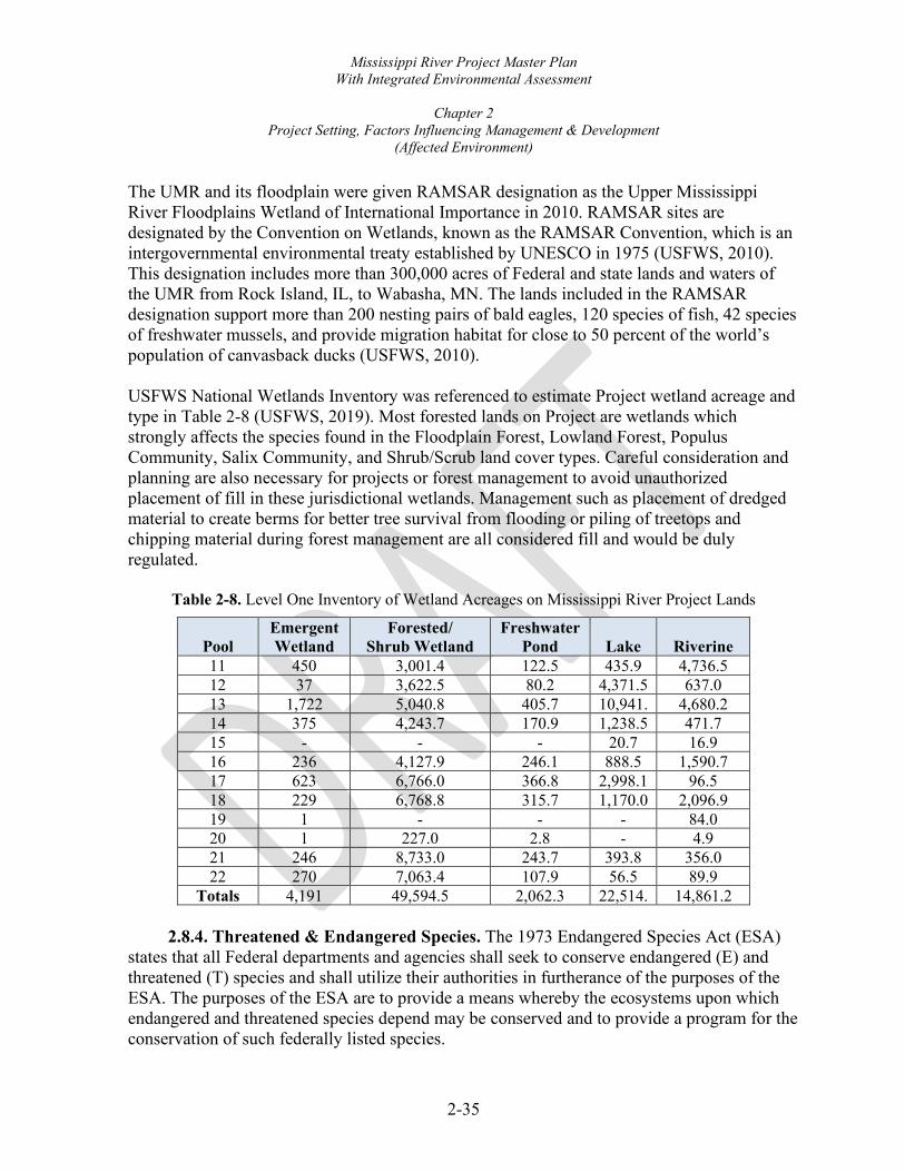
Mississippi River Project Master Plan With Integrated Environmental Assessment
Chapter 2
Project Setting, Factors Influencing Management & Development (Affected Environment)
2-35
The UMR and its floodplain were given RAMSAR designation as the Upper Mississippi River Floodplains Wetland of International Importance in 2010. RAMSAR sites are designated by the Convention on Wetlands, known as the RAMSAR Convention, which is an intergovernmental environmental treaty established by UNESCO in 1975 (USFWS, 2010). This designation includes more than 300,000 acres of Federal and state lands and waters of the UMR from Rock Island, IL, to Wabasha, MN. The lands included in the RAMSAR designation support more than 200 nesting pairs of bald eagles, 120 species of fish, 42 species of freshwater mussels, and provide migration habitat for close to 50 percent of the world’s population of canvasback ducks (USFWS, 2010). USFWS National Wetlands Inventory was referenced to estimate Project wetland acreage and type in Table 2-8 (USFWS, 2019). Most forested lands on Project are wetlands which strongly affects the species found in the Floodplain Forest, Lowland Forest, Populus Community, Salix Community, and Shrub/Scrub land cover types. Careful consideration and planning are also necessary for projects or forest management to avoid unauthorized placement of fill in these jurisdictional wetlands. Management such as placement of dredged material to create berms for better tree survival from flooding or piling of treetops and chipping material during forest management are all considered fill and would be duly regulated.
Table 2-8. Level One Inventory of Wetland Acreages on Mississippi River Project Lands
Pool Emergent Wetland
Forested/ Shrub Wetland
Freshwater Pond Lake Riverine
11 450 3,001.4 122.5 435.9 4,736.5 12 37 3,622.5 80.2 4,371.5 637.0 13 1,722 5,040.8 405.7 10,941.
4,680.2
14 375 4,243.7 170.9 1,238.5 471.7 15 - - - 20.7 16.9 16 236 4,127.9 246.1 888.5 1,590.7 17 623 6,766.0 366.8 2,998.1 96.5 18 229 6,768.8 315.7 1,170.0 2,096.9 19 1 - - - 84.0 20 1 227.0 2.8 - 4.9 21 246 8,733.0 243.7 393.8 356.0 22 270 7,063.4 107.9 56.5 89.9
Totals 4,191 49,594.5 2,062.3 22,514.
14,861.2
2.8.4. Threatened & Endangered Species. The 1973 Endangered Species Act (ESA) states that all Federal departments and agencies shall seek to conserve endangered (E) and threatened (T) species and shall utilize their authorities in furtherance of the purposes of the ESA. The purposes of the ESA are to provide a means whereby the ecosystems upon which endangered and threatened species depend may be conserved and to provide a program for the conservation of such federally listed species.

Mississippi River Project Master Plan With Integrated Environmental Assessment
Chapter 2
Project Setting, Factors Influencing Management & Development (Affected Environment)
2-36
The USFWS is the lead agency administering and enforcing the ESA. It is the policy of the Corps that all Project lands and waters will be managed in a manner which assists in the overall conservation of federally listed endangered and threatened species, and the ecosystems upon which they depend. Species and/or their critical habitats that occur on water resources development projects shall be protected and/or conserved in accordance with the ESA, as amended, and with existing statutes. Species which are candidates for listing will also be given consideration. Conservation methods and procedures will be utilized which will enable the inventory and protection of these species of special concern and their habitat, as well as the participation in their recovery. Corps personnel will cooperate in the management of state-listed and protected species.
2.8.4.1. Federally Threatened and Endangered Species. Eighteen plant and animal species have been determined to be potentially occurring within the floodplain or spending a portion of their life within the river or adjacent habitats and are designated as endangered, threatened, or candidate under the authority of the 1973 Federal ESA. These species are listed in Table 2-9.

Mississippi River Project Master Plan With Integrated Environmental Assessment
Chapter 2
Project Setting, Factors Influencing Management & Development (Affected Environment)
2-37
Table 2-9. Federally Threatened and Endangered Species Potentially Occurring Within the Project Area
Common Name
Scientific Name
Federal Status
State Listed in One or More Counties 1 Located in the Project Area
WI IA IL MO Indiana Bat Myotis sodalis Endangered X X X Northern Long-eared Bat Myotis septentrionalis Threatened X X X Gray Bat Myotis grisescens Endangered X X Higgins Eye (pearlymussel) Lampsilis higginsii Endangered X X X X Sheepnose Mussel Plethobasus cyphyus Endangered X X X Spectaclecase (mussel) Cumberlandia monodonta Endangered X X X X Eastern Black Rail Laterallus jamaicensis jamaicensis Threatened X Pallid Sturgeon Scaphirhynchus albus Endangered X X X Eastern Massasauga Sistrurus catenatus Threatened X X X Decurrent False Aster Boltonia decurrens Threatened X X Eastern Prairie Fringed Orchid Platanthera leucophaea Threatened X X X X Western Prairie Fringed Orchid Platanthera praeclara Threatened X Mead’s Milkweed Asclepias meadii Threatened X X X Prairie Bush-clover Lespedeza leptostachya Threatened X X X Northern Wild Monkshood Aconitum noveboracense Threatened X X Rusty Patched Bumble Bee Bombus affinis Endangered Hine’s Emerald Dragonfly Somatochlora hineana Endangered X X Iowa Pleistocene Snail Discus macclintocki Endangered X X
1 Mississippi River Master Planning Project Area Counties (Source: USFWS IPaC March 2021) Wisconsin: Grant Iowa: Clayton, Dubuque, Jackson, Clinton, Scott, Muscatine, Louisa, Des Moines, Lee Illinois: Jo Daviess, Carroll, Whiteside, Rock Island, Mercer, Henderson, Hancock, Adams, Pike, Calhoun Missouri: Clark, Lewis, Marion, Ralls

Mississippi River Project Master Plan With Integrated Environmental Assessment
Chapter 2
Project Setting, Factors Influencing Management & Development (Affected Environment)
2-38
2.8.4.2. Wisconsin, Iowa, Illinois, and Missouri Special Concern, Threatened, and Endangered Species. The States of Wisconsin, Iowa, Illinois, and Missouri have developed lists of species that are considered endangered, threatened, rare and scarce within their respective states. These designations have similar definitions as the Federal definitions, except that the status is at a state level. Many of the state-listed species are common over a much larger geographical area and are considered rare within a particular state because the area lies on the periphery of the species range and have smaller populations. There are some species, however, where the population decline occurs over the entire range of the species. In addition to the endangered, threatened, and rare designations, each state has another category called “Special Concern”. Special concern species are those species that are not rare, threatened, or endangered, but are extremely uncommon in an area or have unique or highly specific habitat requirements and deserve careful monitoring. Species on the periphery of their range, that are not listed as endangered or threatened, may be included in this category along with those species that were once listed as endangered or threatened but now have increasing protected or stable populations. As shown in Table 2-10, there are approximately 214 state-listed species of special concern, threatened, or endangered plants and animals potentially found on Project lands and waters. Appendix H provides a full list of the 214 species.
Table 2-10. State Listed Species Summary
Species WI
1 county IA
9 counties IL
10 counties MO
4 counties Total
(No Duplicates) Plants 9 35 17 22 68 Birds 16 12 17 9 34 Fish 16 9 8 6 25 Mussels 15 10 12 5 24 Insects 7 16 4 3 24 Mammals 6 6 3 5 13 Amphibians 2 2 2 2 7 Reptiles 7 11 8 5 19 Total 78 101 71 57 214
For a full list of species considered for this table see Appendix H. The State Listed and Species of Concern data was compiled from records of species known to occur within and adjacent to the river floodplain corridors. The information was cross referenced using USFWS Refuge Habitat Management Plans, Refuge Comprehensive Conservation Plans, Natural Heritage Databases and county-level records of occurrence from website databases maintained and administered by the WI DNR (2019), IA DNR (2019), IL DNR (2019) and MDNC (2019). These data are not based on comprehensive inventories of the states and the lack of records for a particular area should not be interpreted to mean that

Mississippi River Project Master Plan With Integrated Environmental Assessment
Chapter 2
Project Setting, Factors Influencing Management & Development (Affected Environment)
2-39
significant resources are not present. Further, the type of information tracked and recorded in each database varies by state.
2.8.5. Invasive Species. Invasive plants, animals, diseases, and insects are quickly becoming significant threats to the earth’s biological diversity, as well as human health. Invasive species are defined as species not normally occurring in a specific area and whose introduction results in economic or environmental degradation or harm to human health. These species did not evolve alongside native species within the ecosystem, and therefore often do not have natural predators to control their populations. If left unchecked, these invasive species can proliferate quickly, outcompeting native species and potentially causing severe habitat degradation. There are a number of exotic and native invasive plant species that suppress tree regeneration and native plant species in the floodplain forest by competing for water, sunlight, nutrients, and space. The vast majority of Project lands have some form of invasive species of plant or animal found onsite. While the overall number of invasive plant species is very large and continues to grow, a select number of invasive species are of special concern. These plant species include reed canary grass (Phalaris arundinacea); Japanese hop (Humulus japonicas); bur cucumber (Sicyos angulatus); white mulberry (Morus alba); amur honeysuckle (Lonicera maackii) tree of heaven (Ailanthus altissima) garlic mustard (Alliaria petiolata) and oriental bittersweet (Celastrus orbiculatus); Additional species of special concern include emerald ash borer (Agrilus planipennis); gypsy moth (Lymantria dispar dispar); big head carp (Hypophthalmichthys nobilis); and silver carp (Hypophthalmichthys molitrix). This is not an all-inclusive invasive species list for the Project, but instead a handful of the hundreds of invasive species that have already infested and continue to arrive in the UMRS. The list of invasive species will likely grow in the future and managers must remain vigilant and act quickly as new threats arise. Asian long-horned beetle (Anoplophora glabripennis), round gobies (Neogobius melanostomus), thousand canker disease (Geosmithia morbida) are threats not yet within the Project area but have the potential to be in the future. The Project Operational Management Plan contains additional information on the invasive species.
2.8.6. Ecological Setting. The Mississippi River and its tributaries shaped the landscape and provided the morphological setting for the ecosystem. Broad floodplains with gravel terraces, oxbow lakes, backwater areas, and periodically flooded bottom-land forests now characterize the ecosystem of this large alluvial river. Today, the river continues to direct the dynamics of the ecosystem. One way this occurs is through the river’s annual flood pulse. A river’s flood pulse refers to the annual cycle of the water level, from low flow to flood crest and back to the low elevation (Junk, Bayley, & Sparks, 1989). During years of large flood events, the floodplains do not merely store water, they become part of the flowing river itself, conveying water slowly downstream through the forests and marshes. Over millennia, plant and animal species have adapted to exploit, tolerate, or escape these flood events. The annual flood pulse in the river valley controls the composition of the floral and faunal communities and provides these riparian communities with water, nutrients, and sediments.

Mississippi River Project Master Plan With Integrated Environmental Assessment
Chapter 2
Project Setting, Factors Influencing Management & Development (Affected Environment)
2-40
The vegetation types present in this floodplain are directly related to elevations from the river, and to the frequency, duration, and depth of flooding (Figure 2.7). As a result, riparian communities are among the most diverse and productive on earth, providing habitat for many different species of mammals, birds, fish, reptiles, and amphibians. A wide variety of wildlife thrive in the unique ecological conditions of riverine forests and wetlands. Riparian ecosystems in their natural state provide many basic wildlife needs, such as vegetation for foraging, water for drinking, and lush growth for hiding and nesting cover.
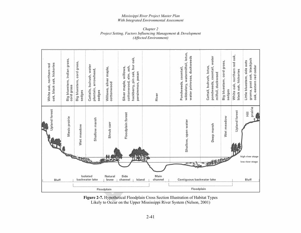
Mississippi River Project Master Plan With Integrated Environmental Assessment
Chapter 2
Project Setting, Factors Influencing Management & Development (Affected Environment)
2-41
Figure 2-7. Hypothetical Floodplain Cross Section Illustration of Habitat Types
Likely to Occur on the Upper Mississippi River System (Nelson, 2001)
.., 0 0 a.
'C ;;
:::, '.!!
0 0 c..
"O .;
:::,
i,:i,
1: =
a, .. n
-;,:
: "'
::
£.
"'"'
--ff) ff) ~
ll.
ii
;,::
ff) _z
<'D
<u
< .
... <'I>
C
.,,
, ~
n =r (
/) Ci
l· -·
::,
Q.
:::,
.,, ~
[ "' :::, a.
g. ~
~ ~-
::,:
:,
~
0 0 :::, -,a· C: 0 C "' ~ "' <> "" :: ~
~ "' " ff) Ol
1: =
Me
sic
pra
irie
We
t m
ea
do
w
Sh
allo
w m
ars
h
Sh
rub
ca
rr
Flo
od
pla
in f
ore
st
,-
, --
-----
-
::!.
!!,
<
<
!!: ~
~
~
.. "
"' "'
....
Sh
allo
w, o
pe
n w
ate
r
De
ep
ma
rsh
We
t m
ea
do
w
Up
lan
d f
or.
est
Wh
ite
oa
k, n
ort
he
rn r
ed
o
ak,
bla
ck o
ak,
hic
kori
es
Big
blu
este
m,
ind
ian
gra
ss,
cord
gra
ss
Big
blu
est
em
, co
rd g
rass
,
sed
ge
s
Ca
tta
ils,
bu
lru
sh,
wa
ter
pla
nta
in,
arr
ow
he
ad
, se
dg.
es
Willo
ws.
silv
er
ma
ple
, co
tto
nw
oo
d
Silv
er
ma
ple
, w
illo
ws,
co
tto
nw
oo
d,
elm
, a
sh,
ha
ckb
err
y, p
in o
ak
, b
ur
oa
k,
pe
rsim
mo
r1,
pe
can
Riv
er
Po
nd
we
ed
s,
coo
nta
il,
wild
cele
ry,
wa
term
ilfo
il,
lotu
s,
wa
ter
pri
mro
se,
du
ckw
ee
ds
Ca
tta
il, b
ulr
ush
, lo
tus,
p
on
dw
ee
d's
, co
on
tail,
wa
ter
milfo
fl,
du
ckw
ee
d
Big
blu
este
m,
cord
gra
ss,
sed
ge
s
Wh
ite
oa
k, n
ort
he
rn r
ed
oa
k,
bla
ck o
ak,
hic
kori
es
Lit
tle
blu
este
m,
sid
e o
ats
gra
ma
, p
ost
oa
k, b
lack
jack
oa
k, e
aste
rn r
ed c
ed
ar

Mississippi River Project Master Plan With Integrated Environmental Assessment
Chapter 2
Project Setting, Factors Influencing Management & Development (Affected Environment)
2-42
2.9. CULTURAL RESOURCES
The most recent revision to the Project’s Historic Properties Management Plan occurred in August 1995 (Benn et al., 1995). Located almost entirely within the Mississippi River alluvial plain, human habitation in and near the Project spans the past 13,000 years. This includes the retreat of glacial ice during the Paleoindian Period through the Archaic and Woodland periods, followed by occupations by Oneota tradition peoples, historic tribes and later, mostly European or Euro-American settlers. Of great significance to the Project is Landform Sediment Assemblage (LSA) modeling. LSAs are geologic units that define the river’s Late Wisconsinan and Holocene alluvial fills. The most complete LSA maps in the entire Mississippi River basin are associated with the Project’s Guttenberg, IA, to Saverton, MO reach (Bettis et al. 1996). The LSA data provides baseline geologic information relating to the archeological potential of landforms throughout the precontact and historic periods, greatly assisting in managing the valley’s cultural resources. For instance, in areas mapped as Kingston Terrace, archeological potential is exceptionally high, sometimes containing more than two dozen Precontact Era sites per square mile. Alternately, landforms comprised entirely of recent alluvium have no precontact habitation potential. This model is dynamic, refined with every new archeological project (e.g., Benn and Blikre 2010; Thompson 2014). Archeological survey, testing and mitigation have occurred at Project lands, although some archeological work pre-dates the utilization of modern field methods. Only a small fraction of the Project’s acreage has been subjected to archeological investigation. State site files and historic preservation offices document surveys on 24,712 land-based acres (Table 2-11).
Table 2-11. Archeological Survey Coverage on the Project’s Lands
Acres
State Total Fee
Title Area 1 Documented
Archeological Survey Percent
Surveyed Iowa 27,768 11,544 45% Illinois 29,959 11,035 34% Missouri 3,321 1,872 58% Wisconsin 2,928 261 9%
Total 63,977 24,712 38% 1 Includes only acquired and accreted lands above the ordinary high-water mark.
Construction has destroyed some recorded sites and shoreline erosion continues to scour other properties away. However, sedimentation mantles some sites in historic alluvium, effectively sealing deposits. In many cases, archeological sites remain in relatively undisturbed contexts, such as high terrace landforms. Some of the Project’s 227 archeological sites on Project lands

Mississippi River Project Master Plan With Integrated Environmental Assessment
Chapter 2
Project Setting, Factors Influencing Management & Development (Affected Environment)
2-43
are located underwater; others are situated along the river's periphery or on adjacent higher elevations. Protective measures employed by the Corps at the Webster Village and Mounds site (11CA44) exemplify efforts to preserve significant Project sites. The Late Woodland Webster Site’s mounds had not yet begun to erode into the river, but village-related features were being lost to riverbank erosion. Shoreline stabilization at the site utilized 7,100 tons of riprap placed along 700 feet of exposed cutbank (Benn and Bettis 1996; Corps 2001). Most of the Project’s sites have no associated National Register of Historic Places (NRHP) eligibility determinations or NRHP recommendation provided by the investigating archeologist. NRHP-listed sites are limited to two properties: 47GT266, the Woodland culture Hog Hollow site, which includes at least one house remnant, and 13DB9, the National Historic Landmark, a ca. 1780–1830 Meskwaki Village, known as Kettle Chief or Peosta’s Village. Other determinations or recommendations include 36 NRHP-eligible, 29 potentially eligible, and 59 ineligible sites. The remaining 101 archeological sites on Project lands have no recorded NRHP eligibility recommendation. An NRHP Multiple Property Documentation form that relates to the nomination of 38 prehistoric sites–many on Corps-managed land–was prepared, but not finalized (Benn & Halvorson, 2001). Table 2-12 depicts information on known Project land archeological sites. Site counts on surrounding lands are included as a reminder that other potentially significant sites may be situated in close proximity to Project lands.
Table 2-12. Archeological Sites On and Near the Project’s Fee Title Lands
Site Counts ESAs
(fee title land only)
State On Fee
Title Land Outside Fee Title Land, But Within 500 Meters Yes No
Iowa 122 349 80 42 Illinois 69 244 58 11 Missouri 12 41 6 6 Wisconsin 24 141 24 0 Total 227 775 168 59
Seventeen sites have yielded human remains or are prehistoric mounds and therefore may contain human remains. These include four sites in Iowa, twelve in Illinois, and one in Wisconsin. There are no known mortuary-related sites on the Project’s Missouri lands. A breakdown of sites by their cultural affiliation is included in Table 2-13.

Mississippi River Project Master Plan With Integrated Environmental Assessment
Chapter 2
Project Setting, Factors Influencing Management & Development (Affected Environment)
2-44
Table 2-13. Cultural Affiliations of Archeological Sites on the Project’s Lands 1
Iowa Illinois Missouri Wisconsin Site Totals Paleoindian 2 - - 1 3 Archaic 17 5 - 1 23 Woodland 48 28 - 7 83 Mississippian - 1 - - 1 Late Prehistoric 16 - 1 - 17 Protohistoric - 1 1 - 2 Precontact, unspecified 41 31 7 9 88 Historic American Indian 6 - - - 6 Historic Other 57 17 7 7 88 Total Sites 122 69 12 24 227 Total Components 187 83 16 25 -
1 A single site may express more than one affiliation and may have been occupied at multiple points in time. Known Paleoindian Period (12,000–9,500 B.P.) sites on Project lands are limited to the Osceola site, utilized from the Paleoindian through Woodland eras (47GT24; Overstreet 1984); Sand Run, with occupations extending through the Oneota tradition (13LA3); and Snively Access II (13LA99; Benn & Isenberger, 2003). Paleoindian populations consisted of small groups of highly mobile hunter-gatherers who seasonally followed big game herds, although a variety of resources were exploited. The artifacts most distinctively linked this period are large, lanceolate (leaf-shaped) projectile points. The Project’s Archaic Period (9,500–2,500 B.P.) inhabitants are represented by at least 23 sites. Compared to the Paleoindian Period, the number of persons living in small settlements increased, sometimes forming small villages during the Archaic. A greater diversity of lithic (stone), animal, and plant resources appear in the archeological record. More well-studied Archaic components are found at the Blanding Landing occupation site (11JD113; Corps, 1985), Sand Run West (13LA38; Benn 1987), and at the Crooked Slough site (11JD125; Benn et al. 2005). This latter site is deeply buried (2.5 m below surface) and notable for the Archaic Durst phase and possible Preston phase components preserved in a floodplain setting. Although some crop domestication occurred during the Late Archaic, not until the Woodland Period (2,500-400 B.P.) did farming intensify. This reliability on crops meant that people could live at one location longer, since there was a dependable food supply. Village size increased, food storage pits became common, and ceramics were developed to aid in food processing. A greater variety of exotic raw materials and finished goods can be found, showing that trade networks became increasingly complex. The Project lands include 83 identified Woodland sites, including mounds, villages, houses, and camps. More well-studied predominantly Woodland era sites include the Black Sand variant Early Woodland habitation Lacey site (13LA288; Benn 2007); Thomson Causeway, an Early Woodland habitation and Middle Woodland mound (11CA11; Esarey and Carlson 1983; Ross
Mississippi River Project Master Plan With Integrated Environmental Assessment
Chapter 2
Project Setting, Factors Influencing Management & Development (Affected Environment)
2-45
and Anderson 1990); the Havana-Hopewell village of Putney Landing (11HE3; Markman 1988); and the Tippies Lake Late Woodland seasonal camp site (11JD132; Benn et al. 2005). The previously mentioned Crooked Slough site’s Early and Late Woodland components are well-preserved atop Archaic horizons. Seventeen Late Prehistoric sites are recorded at the Project, nearly all of which are identified as Oneota tradition (1,000–300 B.P.). Oneota sites typically contain distinctive, shell-tempered pottery. A preponderance of evidence suggests several modern tribes descend from Oneota peoples, including the Baxoje (Ioway), Ho-Chunk/Winnebago, Oto-Missouri, Omaha, and Ponca (for discussion, see Green et al. 2001). The most notable Late Prehistoric evidence on Project lands is a cluster of 16 sites along a 9-mile stretch of river in Louisa County, IA, with most of those sites located at Lake Odessa. Some later-dating Oneota sites were occupied during the Protohistoric or Early Historic periods. Protohistoric refers to a transitional era, when European trade goods were reaching a region, in this case, the Upper Mississippi Valley, but there was no face-to-face contact between native groups and Europeans. Site 11MC122 may represent a protohistoric winter camp. Archival resources suggest the most likely site occupants were members of one of the Illiniwek tribes or, less likely, the Ioway, Sauk, or Meskwaki (Nolan & Mansberger, 1989). This site serves as a good example of variable levels of preservation at a single property–erosion affects the site along the shoreline, but further from the river, the site is protected by between 1.5 and 2.0 m of historic alluvium. The arrival of Marquette and Joliet to the UMR in 1673 represents the first known European contact with native peoples there. The Mississippi was an important route for many well-documented European explorations; sometimes, the explorer’s journals and related maps mentioned specific tribes. None of the earliest explorer-mentioned villages are thought to be within the Project’s boundaries. Very little is known about the four recorded historic American Indian sites on Project lands. The location of Peosta or Kettle Chief’s Meskwaki village (13DB9) is known, although site layout is not understood. The other three sites are not field verified. Reported sites include a Sauk or Meskwaki village near the mouth of the Wapsipinicon (13CN36; Benn et al. 1989) and a Sauk village and cemetery on the south side of the City of Bellevue, IA (13JK325; Morrow 2014). Black Hawk’s Council House is recorded in the Bellevue (13JK326; Western Historical 1879:542–543). Other historic American Indian sites are mentioned at or near Project lands but have not been assigned site numbers. In Iowa, these include a Meskwaki village reported about three miles above the mouth of the Turkey River in 1819 (Forsyth 1880:145) and another situated near Princeton in 1805 (Downer 1910:48); a ca. 1819 Sauk or Meskwaki village near LeClaire (Forsyth, 1880); a battlefield where the Meskwaki fought the Kaskaskia near the mouth of Tete des Morts Creek (Coues 1895:28); and a ca. 1835 Sauk or Meskwaki village at the

Mississippi River Project Master Plan With Integrated Environmental Assessment
Chapter 2
Project Setting, Factors Influencing Management & Development (Affected Environment)
2-46
mouth of the Elk River (Wolfe 1911:49). In Illinois, Zebulon Pike’s 1805 expedition mentioned a Sauk village near the mouth of Henderson Creek. Other Indian villages are reported along this stretch of the river, but not in close proximity to Project lands. Following Meskwaki and Sauk removal from the area by 1832 and Ho-Chunk/Winnebago removal from northeast Iowa’s Neutral Ground in 1848, Euro-American settlers arrived, quickly purchasing all available lands and converting much of the moderately sloped prairie and timber into farmland. There are 94 known historic era archeological sites on Project lands, many of which are habitations, along with other site types such as mills (7GT94), hydroelectric plants (13JK218), and the town sites of Lafayette and Sinipee, WI (47GT196, 47GT546). Submerged shipwrecks, navigational markers and related structures may also be present in the Project’s managed waters, although none have been designated archeological sites (Custer and Custer 1997). In addition to archeological resources, there are significant districts, buildings, structures, and objects within the Project, including ones related to the lock and dam system, buildings that served administrative functions, cottages on leased lands, and bridges. A small portion of the Rock Island Arsenal Historic District, listed on the NRHP in 1969, is situated on Project land. The Clock Tower Building (a.k.a., Storehouse A), on Project land, is a contributing element to that district. This building became a contributing element of the Rock Island Arsenal Rodman Plan Old Stone Buildings District, designated a National Historic Landmark in 1988 (Slattery 1987). Also, of preeminent importance to the Project and to our nation are resources contributing to the significance of the NRHP Multiple Property listing, Upper Mississippi River Federal Navigation Projects, 1931–1948, accepted into the NRHP system in 2004 (Rathbun, 2000). This document recognizes 25 districts with 158 contributing and 409 non-contributing resources between Pools 3–22. Some of the contributing resources include locks, dams, other structures (e.g., a boat harbor, bridges, dikes, guide wall extensions, hoist towers, levees, a traveling crane), buildings (control stations, a lock operator’s house, power houses, a restroom, storage houses), and objects (wall control stands, stage recorders). Other inventoried NRHP-listed, eligible, or potentially eligible architectural properties on or immediately adjacent to Project lands include one cottage and a pump station in Iowa and four bridges crossing the Mississippi River between Iowa and Illinois. There is presently no defined Traditional Cultural Properties (TCP) on Project lands, although many tribal groups consider mounds, mound groups, and mortuary features to possess traditional cultural value. No systematic effort has been made to define TCPs in the Project.

Mississippi River Project Master Plan With Integrated Environmental Assessment
Chapter 2
Project Setting, Factors Influencing Management & Development (Affected Environment)
2-47
2.10. DEMOGRAPHICS The primary zone of interest for the socio-economic analysis of the Project consists of 24 counties bordering the Project along the Mississippi River. There is one county in Wisconsin, nine in Illinois, five in Missouri, and nine in Iowa. Analysis of trends in population, income, education, and race is included in the following sections.
2.10.1. Population. Within the limits of the District, the Project is in a fairly densely populated area that is punctuated with locations of high industrial concentration. Based on the 2010 census, within the two counties inland on each side of the river, or approximately 50 miles, a there are more than 1,587,897 residents, 941,837 of whom are classified as urban dwellers and 646,060 rural dwellers. The counties in the analyzed area are primarily comprised of towns and rural areas. Table 2-14 provides a comparative summary of population trends within these counties. The 2015 population represents a 1.8% increase since 1990 but only 0.2% increase since 2010, revealing an essentially stable population. The States of Wisconsin, Illinois, Missouri, and Iowa had an estimated population increase of 1.0% between 2010 and 2015 (Census 2015). While statewide populations in the four states have been stable to slightly increasing for this timeframe, county population trends are more variable. The general population trends observed within the counties of interest show increases in highly populated counties with decreases in counties with low populations. This trend has been observed across much of the nation as more people move to more urban settings and rural areas continue to see population declines. Due to overall lack of substantial population growth within the Project area, additional development within the Project is not required. IN its current state, the Project is large enough to host the variety of users with few issues.

Mississippi River Project Master Plan With Integrated Environmental Assessment
Chapter 2
Project Setting, Factors Influencing Management & Development (Affected Environment)
2-48
Table 2-14. Population Trends Within Project Area
1990
Population 2010
Population 2015
Population % Change 1990-2010
% Change 2010-2015
% Change 1990-2015
Grant County, WI 49,266 51,208 52,250 3.9 2.0 6.1 Clayton County, IA 19,054 18,129 17,644 -4.9 -2.7 -7.4 Dubuque County, IA 86,403 93,653 97,125 8.4 3.7 12.4 Jackson County, IA 19,950 19,848 19,444 -0.5 -2.0 -2.5 Clinton County, IA 51,040 49,116 47,768 -3.8 -2.7 -6.4 Jo Daviess County, IL 21,821 22,677 22,086 3.9 -2.6 1.2 Carroll County, IL 16,805 15,388 14,615 -8.4 -5.0 -13.0 Whiteside County, IL 60,186 58,498 57,079 -2.8 -2.4 -5.2 Scott County, IA 150,973 165,224 172,126 9.4 4.2 14.0 Muscatine Co., IA 39,907 42,749 43,011 7.1 0.6 7.8 Rock Island Co., IL 148,723 147,546 146,133 -1.0 -1.0 -1.7 Louisa County, IA 11,592 11,387 11,185 -2.0 -1.8 -3.5 Des Moines Co., IA 42,614 40,325 40,055 -5.3 -0.7 -6.0 Lee County, IA 38,687 35,862 35,089 -7.3 -2.2 -9.3 Mercer County, IL 17,290 16,434 15,858 -4.9 -3.5 -8.3 Henderson Co., IL 8,096 7,328 6,995 -9.5 -4.5 -13.6 Hancock County, IL 21,373 19,104 18,543 -10.6 -2.9 -13.2 Adams County, IL 66,090 67,103 67,103 1.5 0 1.5 Pike County, IL 17,577 16,430 15,989 -6.5 -2.7 -9.0 Clark County, MO 7,547 7,129 6,801 -5.5 -4.6 -9.9 Lewis County, MO 10,233 10,211 10,207 -0.2 0 -0.3 Marion County, MO 27,682 28,781 28,880 4 0.3 4.3 Ralls County, MO 8,476 10,167 10,196 19.9 0.3 20.3 Pike County, MO 15,969 18,516 18,348 15.9 -0.9 14.9 Zone Total 957,354 972,813 974,530 1.6 0.2 1.8

Mississippi River Project Master Plan With Integrated Environmental Assessment
Chapter 2
Project Setting, Factors Influencing Management & Development (Affected Environment)
2-49
2.10.2. Housing. Table 2-15 shows selected housing characteristics related to number of units, median value, vacancy rate, and size of household, from the United States Census Bureau website (2015). According to the 2010 U.S. Census, there were a total of 439,256 housing units within the surrounding counties. Approximately 74% of the housing units are owner occupied, with an average household size of approximately 2.4 people per unit.
Table 2-15. Housing Characteristics 2011-2015 Within Project Area
Total Housing
Units 2015 % Owner Occupied
Median Value (Owner Occupied)
Average Household Size
Grant County, WI 21,581 70.8 $133,200 2.44 Clayton County, IA 9,036 78.4 $106,700 2.30 Dubuque County, IA 40,588 72.4 $149,400 2.41 Jackson County, IA 9,480 75.0 $114,300 2.29 Clinton County, IA 21,836 73.7 $110,100 2.36 Jo Daviess County, IL 13,594 78.9 $138,900 2.33 Carroll County, IL 8,408 76.8 $95,700 2.22 Whiteside County, IL 25,737 75.3 $99,200 2.40 Scott County, IA 73,279 68.1 $148,200 2.46 Muscatine Co., IA 18,031 73.9 $126,900 2.59 Rock Island Co., IL 65,864 69.5 $113,800 2.36 Louisa County, IA 5,004 77.8 $99,900 2.58 Des Moines Co., IA 18,456 73.7 $98,200 2.36 Lee County, IA 16,164 74.4 $85,400 2.40 Mercer County, IL 7,356 78.1 $98,000 2.40 Henderson Co., IL 3,819 78.7 $87,100 2.26 Hancock County, IL 9,215 79.3 $83,400 2.35 Adams County, IL 29,994 70.7 $110,000 2.44 Pike County, IL 7,933 77.5 $75,300 2.34 Clark County, MO 3,450 76.4 $84,000 2.42 Lewis County, MO 4,493 73.7 $83,800 2.45 Marion County, MO 12,987 64.9 $103,700 2.43 Ralls County, MO 5,126 80.4 $112,100 2.53 Pike County, MO 7,825 72.3 $95,000 2.47
2.10.3. Income & Education. Table 2-16 displays median household income and
percentage level of education by county obtained from the United States Census Bureau website (2015).

Mississippi River Project Master Plan With Integrated Environmental Assessment
Chapter 2
Project Setting, Factors Influencing Management & Development (Affected Environment)
2-50
Table 2-16. Income and Education 2011-2015 Within Project Area
Median Income
Persons Below Poverty Level (%)
High School Graduates (%)
Bachelor’s Degree or Higher
Grant County, WI $49,067 14.0 91.4 21.3 Clayton County, IA $48,007 11.2 91.9 16.8 Dubuque County, IA $54,605 12.0 92.1 28.7 Jackson County, IA $49,028 12.9 90.7 15.3 Clinton County, IA $50,498 13.4 91.5 19.6 Jo Daviess County, IL $53,221 9.4 92.3 23.6 Carroll County, IL $48,631 10.7 90.5 16.2 Whiteside County, IL $47,401 12.8 88.1 16.9 Scott County, IA $55,114 12.4 92.6 32.1 Muscatine Co., IA $53,676 11.5 86.2 18.8 Rock Island Co., IL $48,817 13.3 88.1 22.0 Louisa County, IA $51,144 10.8 82.4 13.2 Des Moines Co., IA $44,423 14.7 91.4 20.0 Lee County, IA $43,312 15.9 91.5 15.5 Mercer County, IL $54,757 10.1 91.7 15.7 Henderson Co., IL $47,672 11.5 88.0 13.9 Hancock County, IL $47,699 12.7 91.9 20.3 Adams County, IL $45,965 13.4 91.3 21.2 Pike County, IL $40,588 15.0 87.5 15.2 Clark County, MO $43,883 14.7 87.0 12.8 Lewis County, MO $43,909 16.3 87.6 13.5 Marion County, MO $40,814 17.7 84.3 19.4 Ralls County, MO $47,345 11.5 87.4 12.3 Pike County, MO $41,750 18.2 79.1 12.7
2.10.4. Race and Origin. Table 2-17 shows the ethnic composition of the population by county, from the United States Census Bureau website (2015)

Mississippi River Project Master Plan With Integrated Environmental Assessment
Chapter 2
Project Setting, Factors Influencing Management & Development (Affected Environment)
2-51
Table 2-17. Population by Race and Origin 2015 within Project Area
White African
American Other Hispanic or
Latino Origin Grant County, WI 95.4 1.4 1.7 1.5 Clayton County, IA 96.2 0.7 1.5 1.8 Dubuque County, IA 91.4 3.2 3.1 2.3 Jackson County, IA 95.8 0.7 2.1 1.4 Clinton County, IA 91.3 3.3 2.3 3.1 Jo Daviess County, IL 94.7 3.3 1.5 3.2 Carroll County, IL 93.4 1.1 2.0 3.5 Whiteside County, IL 93.4 1.8 1.6 12.0 Scott County, IA 80.9 7.6 5.1 6.4 Muscatine Co., IA 77.9 2.4 2.2 17.5 Rock Island Co., IL 72.9 10.2 4.2 12.7 Louisa County, IA 79.4 1.0 3.4 16.2 Des Moines Co., IA 87.6 6.1 3.1 3.2 Lee County, IA 91.1 3.1 2.4 3.4 Mercer County, IL 95.8 0.6 1.3 2.3 Henderson Co., IL 96.2 0.2 1.8 1.8 Hancock County, IL 96.5 0.5 1.6 1.4 Adams County, IL 92.1 3.8 2.6 1.5 Pike County, IL 95.4 2.0 1.3 1.3 Clark County, MO 97.0 0.3 1.8 0.9 Lewis County, MO 92.6 3.3 2.5 1.6 Marion County, MO 90.3 5.1 3.0 1.6 Ralls County, MO 95.8 1.3 1.9 1.0 Pike County, MO 88.4 7.5 2.1 2.3
2.10.5 Environmental Justice. Environmental justice (EJ) is defined as the fair treatment and meaningful involvement of all people, regardless of race, color, national origin, or income, with respect to the development, implementation, and enforcement of environmental laws, regulations, and policies. The EPA further defines fair treatment to mean that no group of people should bear a disproportionate share of the negative environmental consequences of industrial, governmental, or commercial operations or policies. Executive Order 12898: Federal Actions to Address Environmental Justice in Minority Populations and Low-Income Populations (February 16, 1994) provides that each Federal agency shall make achieving environmental justice part of its mission by identifying and addressing disproportionately high and adverse human health or environmental effects of its programs, policies, and activities on minority populations and low-income populations. Environmental justice concerns may arise from impacts on the natural and physical environment, such as human health or ecological impacts on minority populations, low-income populations, and Indian tribes or from related social or economic impacts.

Mississippi River Project Master Plan With Integrated Environmental Assessment
Chapter 2
Project Setting, Factors Influencing Management & Development (Affected Environment)
2-52
Environmental Justice) was assessed for the project study area using the EPA’s Environmental Justice Screening and Mapping Tool (EJ Mapper; https://www.epa.gov/ejscreen). Data for the environmental indicators show that all are in mid to low percentiles (<60%) compared to the rest of the state, suggesting there are very few areas of concern with air and water quality or other environmental factors. Queries of the EJ Mapper shows the project area and surroundings contain a mix of income levels and very few minority populations. 2.11. ECONOMICS Economic data on the Recreation Value to the Nation for the Project in FY2019 reveals that there were 1,712,476 visits to the Project resulting in $70,996,183 in visitor spending, $35,168,219 in sales, 603 jobs, $14,020,989 in labor income, and $18,959,320 in value added within 30 miles of the Project, Corps projects and $15,561,652 in National Economic Development (NED) benefits. With multiplier effects, visitor trip spending resulted in $52,865,130 in total sales, 744 jobs, $19,219,154 in labor income, $28,357,897 in value added (wages & salaries, payroll benefits, profits, rents, and indirect business taxes). The money spent by visitors to Corps projects on trip expenses adds to the local and national economies by supporting jobs and generating income. Visitor spending represents a sizable component of the economy in many communities around Corps projects. 2.12. RECREATION FACILITIES, ACTIVITIES, AND NEEDS The Mississippi River Valley has long served as a source of recreational opportunity with its scenic environment, fish, wildlife, water resources, and temperate climate. Endowed with the basic requirements for outdoor activities, the 9-foot channel project has further enhanced the recreational potential of the area. No longer do periods of drought reduce river stages to the point where navigation becomes hazardous or impossible, and the relatively stable pools created by the project provide large water areas for water skiing, fishing, and other water-related activities. Numerous marinas and boat-launching facilities, situated along the shores of the pools, make recreational boating safer and more pleasurable. The recreational developments at the Project provide opportunity for outdoor recreation activities such as sightseeing, fishing, hunting, boating, camping, and picnicking. Areas along the river have been developed to provide both extended-use and day-use opportunities. A description of land use and recreational development is presented in Chapter 5, Resource Plan. The Use Fee Criteria appendix of Engineering Pamphlet 1130-2-550, Recreation Operations and Maintenance Guidance and Procedures, designates what amenities and services are required for specific classifications of campgrounds. There are five classifications, the 3 most common of which are Class A, B and C, with Class A including the most amenities.
Mississippi River Project Master Plan With Integrated Environmental Assessment
Chapter 2
Project Setting, Factors Influencing Management & Development (Affected Environment)
2-53
2.12.1. Recreation Areas. Land-based recreation activities include camping, picnicking, biking, hiking, shore fishing, hunting, bird and wildlife watching, cross country skiing, geo-caching, and sightseeing on or adjacent to Project land. Land-based recreation facilities include campgrounds, picnic areas, overlooks, boat ramps, land access points, visitor centers, and wildlife management areas. Facility types typically found within these recreation areas typically include restrooms, shower buildings, campsites, picnic shelters, picnic sites, playgrounds, horseshoe pits, and trails. Water-based recreation activities occurring on the Mississippi River such as pleasure boating, fishing, waterfowl hunting, sailing, swimming, canoeing, kayaking, water skiing and tubing, and paddle boarding. Facilities associated with water-based recreation activities include marinas, boat ramps, docks, and restrooms. Recreation areas at the Project are managed by several entities, which include the Corps, the USFWS, state agencies, county conservation boards, city governments and private entities. There are approximately 65 recreational outgrants including 12 marinas, 16 campgrounds, and 51 boat ramps. Recreation areas and amenities managed by the Corps are in Table 2-18. Corps-managed recreation areas are further described in Chapter 5, Resource Plan.

Mississippi River Project Master Plan With Integrated Environmental Assessment
Chapter 2
Project Setting, Factors Influencing Management & Development (Affected Environment)
2-54
Table 2-18. Corps Recreation Areas and Amenities, Mississippi River Project (Corps, 2020)
* Reservations accepted through R1S **Seasonal availability
US Army Corps of E11ijlnHrs4
Rock l!lland DIBMcl
RECREATION AREA 1. Grant River• 11 WI 73 • •
2. Lock & Dam No. 11 11 IA 0
3. Blanding Landing 12 IL 37 • •
4. Pleasant Creek 13 IA 27 •
5. Big Slough 13 IL 0
6. Thom50n Causeway" 13 IL 131 • •
7. Bulger's Hollow 13 IA 23 •
8. Lock &: Dam No. 13 13 IL 0
9. Cattail Slough 14 IL 0
10. Fisherman's Comer• 14 IL 56 • •
11. Locks & Dam No. 14 14 IA 0
12. Missi ssi ppi River Visitor Center 15 IL 0
13. Andalusia Slough 16 IL 0
14. Clark's Ferry" 16 IA 43 • •
15. Shady Creek" 16 IA 52 • •
16. Lock&:Dam No.16 16 IL 0
17. Blanchard l!sland 17 IL 15 •
18. Kilpeck Landing 17 IA 0
19. Ferry Landing 18 IA 0
20. Fenway Landing 20 MO 0
21. Bear Creek*" 21 IL 18
22. Canton Chute 21 IL 0
23. Lock &: Dam No. 21 21 IL 0
24. John Hay 22 IL 0
25. Park-N-Fish 22 IL 0
26. Lock &: Dam No. 22 24 MO 0
• • • • • • • • 12
39
• • • • • • • • • 15
• • • • • 18
• 36
• • • • • I I ,e 20
• • I I ,f 22
• • • • • • • 36
• 36
• • • • • 26
• • 36
., . 28
• • 36
• • • • • • • ,. • 30
• • • • • • • • • 32
• 39
• • I t 34
I t 36
I t 37
36
37
39 ., . 35
• • • 36
• • 37
37

Mississippi River Project Master Plan With Integrated Environmental Assessment
Chapter 2
Project Setting, Factors Influencing Management & Development (Affected Environment)
2-55
2.12.2. Zones of Influence. The primary zones of influence for the Project encompass the bordering cities/counties up and down the Mississippi River. These zones have been utilized as the basis in summarizing the population characteristics for the Project. The combined estimated total population of counties that border the project is 974,530 according to the US Census Bureau’s 2015 American Community Survey. Overall, this region saw a 1.0 percent growth in population since the 2010 census. The areas growth is relatively stable with some urbanization in the Quad Cities and Dubuque area.
Figure 2-8 depicts the state of residence visitors who camped at Class A campgrounds with reservable camping on the Project from 2008 to 2016. As expected, the largest number of visitors come from the states bordering the Project, with Illinois, Iowa, and Wisconsin making up the zones of influence. Figure 2-9 further illustrates the zones of influence with the display of visitors by county of residence that attend Project recreation areas. Counties that border the Mississippi River in Eastern Iowa, Northern Illinois and Southern Wisconsin produce the highest amount of visitation to recreation areas in the Project. Primary zones of influence are within a 30-minute drive of the Project. Because of their proximity to the Project, residents in the primary area of influence make the Project a destination for recreational opportunities that are available.

Mississippi River Project Master Plan With Integrated Environmental Assessment
Chapter 2
Project Setting, Factors Influencing Management & Development (Affected Environment)
2-56
Figure 2-8. Visitor Numbers for Camping at Project Class A Campgrounds from 2008 to 2016 as Shown by State Residence (Corps, 2016)
24
Legend
Mississippi River Totals
e 1 - 100
• 101-1 ,000
• 1,001 - 10,000
- 10,001-31 ,779
't 33
Hawaii Inset
• 15
Rock Island District - Mississippi River Visitors 2008 - 2016
21.
• t14
3
• 21

Mississippi River Project Master Plan With Integrated Environmental Assessment
Chapter 2
Project Setting, Factors Influencing Management & Development (Affected Environment)
2-57
Figure 2-9. Low to High Visitation for Camping at Project Class A Campgrounds
from 2008 to 2016 as Shown by County (Corps, 2016)
SK
MT
WY
co KS
NM
TX
NO
"
MB
Rock Island District - Mississippi River Project Recreation Area Visitors By County 2008 - 2016
~: ! Rock Island Dis1rict Boundary
[] State Boundaries
__'.J County Boundaries
OK
ON
OH
IN
TN
NC
Mississippi River Project Master Plan With Integrated Environmental Assessment
Chapter 2
Project Setting, Factors Influencing Management & Development (Affected Environment)
2-58
2.12.3. Visitation Profile. The Mississippi River has traditionally provided recreational opportunities over the years and continues to be a popular recreation destination in the area. Most of the visitors to the Project come from the bordering counties. The diverse population consists of campers who utilize campgrounds, hunters, marina customers who utilize the multiple marinas, day users, adjacent residents, and cottage site leases. The Mississippi River is the primary location for water-related recreation in the area. It provides the public a location for boating, sailing, kayaking, paddle boarding, fishing, and swimming. On average, the Project entertains approximately 2.7 million visits per year (Corps, 2017). R1S records indicate that in 2019, 53 percent of camping reservations received a discount through the America the Beautiful passes for people over the age of 62.
2.12.4. Recreational Carrying Capacity and Analysis. The facilities available provide
a place for the surrounding population to enjoy outdoor recreation opportunities and reconnect to nature. While visitation in recreation areas remains strong, there are indications that there is new demand for upgraded facilities and non-traditional recreation opportunities. Recreation has evolved into a modernized and high-tech activity since the construction of the Project’s recreation areas. For example, sewer hookups, 50-amp electrical hookups, concrete sites, and wireless internet are becoming the new standard for campers. Technology has changed the habits of modern camping and campgrounds are important part of the Project’s recreation program. There is also an increasing demand for water related recreation activities. Overall, the current availability of boat launch locations seems adequate, however, there are places that come to capacity or near capacity during holiday weekends. Recreational carrying capacity at the Project is influenced by environmental, topographic, cultural, and geographical factors and constraints. Recreation areas are often affected by recurring flooding along the Mississippi River due to their location in a low topography area adjacent to the river. The Mississippi River and its floodplain also possess a strong Native American history, resulting in cultural resource protection needs which limit management activities in current recreation areas as well as any expansion or building of new recreation areas. The lands originally acquired for project purposes were relatively close in nature to the Mississippi River, which resulted in a limited operation footprint and has curtailed any future expansions to current recreation areas or building of new areas. Table 2-19 displays the estimated number of visits by year to each Class A campground in the Project. Visitation reported by the Project is through the Visitor Estimation Reporting System (VERS). Low visitation in 2018 and 2019 was due to flooding along the Mississippi River. 2017 portrays an average year of visitation without flooding. The total visitation for all Corps-managed recreation areas at the Project was 814,016 in 2017 (VERS 2020).

Mississippi River Project Master Plan With Integrated Environmental Assessment
Chapter 2
Project Setting, Factors Influencing Management & Development (Affected Environment)
2-59
Table 2-19. Mississippi River Project Visitation, Class A Campgrounds (VERS 2020)
Recreation Area, State 2015 2016 2017 2018 2019 Blanding Landing, IL 14,482 15,631 14,930 13,278 11,610 Clark’s Ferry, IA 20,215 34,240 37,341 31,491 26,886 Fisherman’s Corner, IL 31,055 33,038 38,774 31,610 14,811 Grant River, WI 37,148 38,665 47,861 44,208 38,903 Shady Creek, IA 30,325 34,730 33,490 28,363 14,987 Thomson Causeway, IL 47,999 73,453 96,807 95,242 84,728 TOTALS 181,224 229,757 269,203 244,192 191,925
The analysis of current recreation areas show that the majority of the recreation areas are providing adequate space and amenities to support the public demand. Capacities at campgrounds are often reached on weekends and holidays, yet the same campgrounds are less than 50% full during the weekdays. Day use and access points are adequately equipped to support the current visitation, with the exception of during special events such as fishing tournaments when large numbers of visitors gather at one time. 2.13. REAL ESTATE
2.13.1. Acquisition Policy. Project lands were acquired primarily in the 1930s with the authorization and construction of the lock and dam projects. These lands were acquired so that navigation infrastructure could be placed on them or to allow for flooding either directly from pool water or indirectly by raising the water table. Additional lands may only be acquired as deemed necessary to support those original project purposes for the navigation features, dredged material placement areas, or as deemed necessary for mitigation of loss of statutory wetland habitat on current Project lands. Additional lands may also be added by leases as a requirement for land mitigation as a result of non-recreation lease impacts, in accordance with the 2009 Non-Recreation Outgrant Policy or congressionally authorized land exchanges. Navigational servitude, state water laws, and case law also allow for select accreted riparian lands to be included as Project land.
2.13.2. Outgrants on Public Lands. Outgrants of Project land to agencies, organizations, businesses or individuals have been made for the purpose of providing access to recreation opportunities, marina services, utilities, and assisting riverine-related industry or local municipalities through the use of real estate instruments such as leases and easements.
2.13.2.1. Public Recreational Leases. Recreation opportunities in the form of
accesses and parks have been developed by state or local governments. The Corps real estate instrument for public recreational areas is the public park and recreation lease. State recreation areas range from small access areas to large state parks. Four of the Project’s current eleven marina concessions hold a public park and recreation lease.

Mississippi River Project Master Plan With Integrated Environmental Assessment
Chapter 2
Project Setting, Factors Influencing Management & Development (Affected Environment)
2-60
2.13.2.2 Commercial Concession Leases. Commercial concessions on public ground offer marina services for the public. Six of the Project’s current eleven marina concessions hold a commercial concession lease.
2.13.2.3. Private Recreational Leases for Cottage Sites. In 1944, Section 4 of
the Flood Control Act authorized the Secretary of the Army to grant leases of lands at water resources development projects for such periods, and upon such terms and for such purposes as the Secretary may deem reasonable in the public interest. As a result of this, the Government advertised certain sites along the Mississippi River to be developed as recreational cottage sites in the early 1950s. More information on Cottage Site leases is included in Chapter 6, Special Topics, Planning Considerations and Special Concerns.
2.13.2.4. Special Use Licenses for Shoreline Management Structures. These
licenses are for privately owned land-based recreational structures or activities in support of boat moorage and shoreline access in permitted locations as described in the Shoreline Management Plan (Appendix G) and the associated Shoreline Allocation mapping from the 1989 Land Use Allocation Plan. The 1989 Land Use Allocation Plan is superseded by the 2021 Master Plan except for the Shoreline Allocation mapping that is referenced from the SMP until such time the SMP is revised with new mapping. More information on Shoreline Management and private exclusive use can be found in Chapter 6 and in the SMP.
2.13.2.5. Commercial Industrial Leases. The eight leases range from docking
and loading facilities to multipurpose industrial development. These lands are typically not available for other uses. Public access to these areas is mostly prohibited, as posted, given considerations for safety protocols and operating procedures of the facilities.
2.13.3. Easements on Public Lands. Easements and rights-of-way on public lands
include roads and utility lines.
2.13.4. General Plan Lands. See Chapter 6 for discussion of GP lands made available to the USFWS and how they are managed by the USFWS and state wildlife managing agencies for fish and wildlife management purposes.
2.13.5. Corps Easements on Private Lands
2.13.5.1. Roadway Easements. The Project acquired roadway easements for vehicle land access to Locks and other facilities. The number of roadway easements acquired is relatively limited given the expansive boundary and numerous separate parcels. Any new roadway easements required for operation and maintenance of the Project would be reviewed and pursued on a case-by-case basis.
2.13.5.2. Dredged Material Placement Easements. The Project has three
easements for placement of dredged material including Beaver Island in Iowa, Pool 14 near

Mississippi River Project Master Plan With Integrated Environmental Assessment
Chapter 2
Project Setting, Factors Influencing Management & Development (Affected Environment)
2-61
Clinton, IA; Missouri, Pool 21 upstream of LaGrange, MO; and Missouri, Pool 22 upstream of Hannibal, MO.
2.13.5.3. Flowage Easements. Flowage easements were acquired to
compensate landowners for flooding induced by the construction of the lock and dam system. Easements may vary by location and type so the language of individual easements should be directly referenced to identify their specific provisions. However, easements typically involve the right to clear timber, right to overflow, and right to access by the Government. One example deed reads: “…the full, complete and perpetual right, power, and privilege to overflow the property hereinabove more particularly described and designated as Tracts …, both inclusive, together with the right to clear, out and remove all brush, timber and other natural or artificial obstructions located thereon; and the full, complete and perpetual right, power and privilege to overflow the property hereinabove more particularly described and designated as ….” Real Estate is the main point of contact for management of flowage easements. There are no Government-owned facilities on flowage easement areas.
2.13.6. Operation on Other Public Lands. The USFWS provided permission for
construction and operation of Lock and Dam 13 on select USFWS fee title tracts through letters of permission in 1935 and 1936. Project navigation facilities were constructed on state or charter city lands in some select locations under the ordinary high-water mark under navigation servitude that have not required the acquisition of lands.
2.13.7. New Non-Recreation Outgrant Proposals. In executing the Corps’ mission,
districts receive numerous and diverse proposals for use of lands and waters at Civil Works water resources projects. The Non-Recreation Outgrant Policy was first developed jointly by the Real Estate and Operations Communities of Practice in 2009 and subsequently updated in 2013 (Corps, 2013). The purpose of this guidance is to establish a consistent, nationwide policy that will be applied to evaluate non-recreation real estate requests for use of civil Works lands and waters. This guidance is consistent with the Project outgrant management philosophy and shall be implemented for all future non-recreation outgrant requests on project lands and waters. For more information on the non-recreation outgrant proposal process, please refer to Chapter 6. 2.14. PERTINENT PUBLIC LAWS Numerous Federal laws and executive orders establish national policy for, and Federal interest in, the protection, restoration, conservation, and management of natural and cultural resources. These Federal statutes include compliance requirements and emphasize protecting environmental quality. Recent water resources authorizations have enhanced opportunities for the Corps’ involvement in studies and projects to specifically address the restoration of ecological resources and ecosystem management. Specific authorities for new individual

Mississippi River Project Master Plan With Integrated Environmental Assessment
Chapter 2
Project Setting, Factors Influencing Management & Development (Affected Environment)
2-62
studies and projects to restore ecological resources lost or damaged by the project have also been provided in legislation. Examples of legislation that broadly supports Federal involvement in the protection, restoration, conservation, and management natural and cultural resources include, but are not limited to:
• The National Environmental Policy Act of 1969, as amended;
• U.S. Fish and Wildlife Coordination Act of 1958;
• The Endangered Species Act of 1973, as amended;
• The Clean Water Act of 1972;
• Antiquities Act of 1906;
• Archeological Resources Protection Act of 1979;
• National Historic Preservation Act of 1966;
• Federal Water Project Recreation Act of 1965, as amended;
• Flood Control Act of 1944: Section 4 of the act as last amended;
• Forest Cover Act; and
• Water Resources Development Acts of 1986, 1988, 1990, 1992, 1996, 1999, 2000, 2007 and Water Resources Reform and Development Act of 2014.
For a more comprehensive list of pertinent public laws with descriptions, see Appendix D, Applicable Federal Statutes.

3-1
CHAPTER 3
RESOURCE OBJECTIVES 3.1. BACKGROUND Corps policy establishes guidance for administration and management for Corps programs as well as establishing the Natural Resource Management Mission Statement and individual program objectives. These include, in part:
• Engineer Regulation (ER) & Engineer Pamphlet (EP) 1130-2-550, Project Operations – Recreation Operations and Maintenance Guidance and Procedures, 15 November 1996 (with changes 1 Oct 1999, 1 Mar 2002, 15 Aug 2002, 30 Aug 2008, 30 Mar 2009, 30 Jan 2013, and 30 Sep 2013);
• ER & EP 1130-2-540, Environmental Stewardship Operations and Maintenance Policies, 15 November 1996 (with changes 4 Nov 2002, 31 Jul 2005, 11 Aug 2008); and
• ER 1130-2-406, Shoreline Management at Civil Works Projects, 31 Oct 1990.
The rules and regulations governing public use at Corps water resources development projects are published as Title 36 CFR Chapter III, Section 327.0 – 327.30 and enforced by Corps personnel with Title 36 citation authority (see EP 1165-2-316, Rules and Regulations Governing Public Use Of Corps of Engineers Water Resources Development Projects.) The following Project vision, goals, and objectives support the Natural Resource Management Mission along with the Recreation, Environmental Stewardship, and Shoreline Management program objectives. 3.2. RESOURCE VISION The Corps is the steward of the lands and waters at Corps’ water resources projects. Its Natural Resources Management Mission is to manage and conserve those natural resources, consistent with ecosystem management principles, while providing quality public outdoor recreation experiences to serve the needs of present and future generations. In all aspects of natural and cultural resources management, the Corps promotes awareness of environmental values and adheres to sound environmental stewardship, protection, compliance, and restoration practices. The Corps manages for long-term public access to, and use of, the natural resources in cooperation with other Federal, State, and local agencies as well as the private sector; integrates the management of diverse natural resource components such as fish, wildlife, forests, wetlands, grasslands, soil, air, and water with the provision of public recreation opportunities; and conserves natural resources and provides public recreation opportunities that contribute to the quality of American life.

Mississippi River Project Master Plan With Integrated Environmental Assessment
Chapter 3
Resource Objectives
3-2
3.3. RESOURCE GOALS This vision is supported by the following broad management goals for Project areas:
• Manage natural resources on Project administered land and water in accordance with ecosystem management principles; partner agency missions; and the Cooperative Agreement, to ensure their continued availability (see Chapter 6, Section 6.1 for more information on General Plans and Cooperative Agreements);
• Identify and protect environmentally sensitive species, habitats, and landscapes; important cultural resources; and important scientific research locations;
• Avoid and minimize harmful effects to land, water, wildlife, and other ecological resources (natural resources) caused by land or water disturbing activities, and to ensure that any remaining harmful effects are effectively addressed, consistent with existing mission and legal authorities;
• Provide a quality outdoor recreation experience which includes an accessible, safe, and healthful environment for a diverse population;
• Increase the level of self-sufficiency for the Corps recreation program;
• Manage public lands for equitable use available to all members of the public while honoring existing commitments and protecting resources in the public trust;
• Provide for the public’s needs for quality land and water-based recreational experiences on a sustainable basis in accordance with Corps recreation facility standards while maintaining stewardship of Project resources;
• Collaborate with community leaders and academic entities;
• Maintain open communication with the public;
• Optimize the use of leveraged resources such as partnerships, volunteers, in-kind consideration on leases, and other opportunities to maintain and provide quality public experiences;
• Protect, restore, and prudently manage Project floodplain areas; and
• Follow Federal, state, and local laws and regulations.
3.4. RESOURCE OBJECTIVES Resource considerations at the Project exist primarily from needs of navigation, natural resource management, recreational access, and public use. Multiple user types have interests

Mississippi River Project Master Plan With Integrated Environmental Assessment
Chapter 3
Resource Objectives
3-3
in Project lands, recreation facilities, and waters. Demands can differ from each user type and may create conflicts. The Project will manage natural resources for the overall interest of the public and not for a select group of individuals. Natural resource management is the responsibility of Project staff. They will coordinate management activities with District and partner agency staff to seek environmentally sound methods, balance competing interests, and ensure availability of resources for future generations. Impacts on the environment and Project resources will be assessed during the decision-making process prior to any change to management plans, strategies, developments, or policies.
3.4.1. Environmental Stewardship Resource Objectives
1. Manage, promote, restore, and establish important native forest and non-forest community types where best suited to maintain diversity, health, and sustainability on Project lands;
2. Pursue forest target conditions, goals, and objectives described in the Upper Mississippi River Systemic Forest Stewardship Plan. See Chapter 6, Special Topics, Planning Considerations, and Special Concerns and Appendix F, Upper Mississippi River Systemic Forest Stewardship Plan, for more information;
3. Proactively manage habitats or habitat conditions to protect, promote, and benefit federally and state listed special status species;
4. Monitor lands for invasive and exotic species and act, when feasible, to prevent and/or reduce the spread on Project lands;
5. Protect known cultural resources and practice good stewardship to reduce impacts from erosion and management actions; seek funding and update the Project Historic Properties Plan; and identify cultural sites with high significance and highest risk of degradation;
6. Maintain, enhance, develop, and promote communication channels between Project personnel, District staff, and outside agency professionals to maximize cooperative exchange of management philosophies, practices, and implementation;
7. Strive to complete natural resource management actions in a safe manner for public users of Project lands and waters;
8. Carefully evaluate land use requests that will alter current habitat conditions and function as to avoid unnecessary natural resource damage, fragmentation, and permanent loss of environmental benefits; manage private use in line with existing permissions and in balance with Project resources and operational access;

Mississippi River Project Master Plan With Integrated Environmental Assessment
Chapter 3
Resource Objectives
3-4
9. Maintain contact with Federal, state, county, and local government staff; adjoining landowners; businesses; and the public to help ensure understanding of Corps land management responsibilities and policies. See Chapter 6, Special Topics, Planning Considerations, and Special Concerns, for more information;
10. Deter encroachments and trespassing and other Title 36 violations by maintaining an easily recognized Federal property boundary line and performing periodic inspections of the boundary.
11. Resolve encroachment and trespass in a manner that maximizes continued public and operational access to Project lands; the primary means of resolution will be removal; take prompt action to help resolve encroachments and trespass;
12. Inventory, monitor, and interpret current and historic conditions of native ecosystem community types;
13. Revise and follow the Project’s Shoreline Management Plan. See Chapter 6 for more information;
14. Promote and prioritize environmentally preferred erosion control measures on Project lands to balance human needs with the preservation of Project resources. New retaining walls and sea walls on Project lands should only be utilized or authorized when there are no other feasible alternatives and the structure is needed to address a critical Project mission, serious health/safety issue, or to avoid significant real property damage; and
15. Avoid development in the base floodplain unless it is the only practicable alternative; reduce the hazard and risk associated with floods; minimize the impacts of floods on human safety, health and welfare; and restore and preserve the natural and beneficial values of the base flood plain.
3.4.2. Recreation Resource Objectives
1. Proactively manage recreation opportunities for efficiencies and focus resources to recreation areas with the most overall benefit to the public. Pursue sustainable levels of service given limited resources and budgets;
2. Improve and modernize day use and campground facilities where feasible and prudent through addition of amenities, including, but not limited to: sewer hook ups, increased electrical service, concrete RV pads, wireless internet access, amphitheaters, fish cleaning stations, restrooms, trails, and improved park entrance complexes;
3. Provide primitive camping opportunities conducive to night sky viewing;

Mississippi River Project Master Plan With Integrated Environmental Assessment
Chapter 3
Resource Objectives
3-5
4. Improve and expand opportunities for dispersed recreation such as hiking, bird watching, biking and nature study by providing and maintaining trails and wildlife viewing stations in recreation areas;
5. Improve interpretive services through collaboration with partners, construction of amphitheaters and other facilities conducive to group gatherings, and through community outreach programs;
6. Enhance the recreation experience by promoting and protecting water quality, promoting non-consumptive use to protect the resource from overuse, maintaining facilities in a safe and attractive condition;
7. Work with resource agencies to promote public safety and resource protection during public hunting activities;
8. Promote water safety education in recreation areas and Visitor Center through on- and off-site interpretive programming;
9. Work toward universal accessibility in all aspects of the recreation mission. Provide access opportunities that contribute to the quality of life for all ages, ethnic backgrounds, and those with physical limitations; and
10. Provide and maintain river access, where feasible and prudent, by providing adequate boat ramp and parking facilities in designated areas.
3.5. IMPLEMENTATION OF OBJECTIVES Implementation of these objectives is subject to time, manpower, and budget limitations and made challenging by flooding, extensive remote areas, limited land access, and other logistical and physical constraints. These objectives will be pursued through the use of a variety of mechanisms such as assistance from volunteer efforts, partnership agreements, hired labor, contract labor, permit conditions, remediation, and special outgrant conditions. In all management actions, the Project will strive for a reasonable and pragmatic approach to the management of resources. Close coordination with managing agencies, partnering, and pursuit of technological innovations will be critical in these continuing endeavors.

4-1
CHAPTER 4
LAND ALLOCATION, LAND CLASSIFICATION, WATER SURFACE, AND PROJECT EASEMENT LANDS
This Master Plan (MP) is a land use plan where specific parcels of land are classified into land use categories based on resource capability. This MP provides a conceptual guide for use, management, and development of all Project lands. This is not a plan for private lands, lands acquired in fee title by the U.S. Fish and Wildlife Service (USFWS) for refuge purposes, or other non-Corps public lands. The following Land Allocation, Shoreline Management Allocation, and Land Classification information was developed using Engineer Pamphlet (EP) 1130-2-550, EP 1130-2-550, Project Operations – Recreation Operations and Maintenance Guidance and Procedures (30 Jan 2013) guidance, the 1989 Shoreline Management Plan (SMP), and the 1989 Land Use Allocation Plan (LUAP). 4.1. LAND ALLOCATION In accordance with EP 1130-2-550, land allocations identify the authorized purposes for which Project lands were acquired. There are four categories of allocation:
• Operations • Recreation • Fish and Wildlife • Mitigation
The entire 93,600 acres originally acquired for the Rock Island District portion of the Project are allocated for Operations as they were acquired primarily for river navigation. Those lands acquired since the original acquisition relate to navigation through purchase of lands associated with dredged material placement and are also allocated to Operations. Since the original acquisition, Project, and Corps missions such as Recreation and Environmental Stewardship have been added but are not reflected in the allocation as the lands were not originally specifically acquired for these purposes. 4.2. SHORELINE MANAGEMENT ALLOCATION In accordance with Engineer Regulation (ER) 1130-2-400, Management of Natural Resources and Outdoor Recreation at Civil Works Water Resource Projects, shoreline management allocations identify the status and eligibility of lands for private exclusive use, such as for docks and stairs. There are four categories of Shoreline Management allocation:
• Protected • Prohibited Access • Recreation • Limited Development Area (LDA)

Mississippi River Project Master Plan With Integrated Environmental Assessment
Chapter 4
Land Allocation, Land Classification, Water Surface, and Project Easement Lands
4-2
The 1989 SMP referenced the 1989 LUAP for designating Shoreline Management allocations and providing mapping. This MP does not update the Shoreline Management allocation areas, including LDA and authorized private exclusive use in specific locations outside of LDAs, which were designated in the 1989 SMP and associated mapping. Changes to the protected area status would, at a minimum, be completed through a future update or revision of the Shoreline Management Plan (SMP) and associated update to MP mapping. For more information on shoreline allocations, the SMP, and its relation to the MP, refer to Chapter 6, Special Topics, Planning Considerations, and Special Concerns and the 1989 SMP, attached as Appendix G, Shoreline Management Plan. 4.3. LAND USE CLASSIFICATION This MP replaces the land use classification mapping from the 1989 LUAP. Land Use Classifications correspond to the primary use for which Project lands are managed. Project lands are apportioned for development and resource management consistent with authorized Project purposes and the provisions of the National Environmental Policy Act and other Federal laws. A Project map delineating land according to the classifications including Project Operations, High Density Recreation, Environmentally Sensitive Areas, Multiple Resource Management Lands, Water Surface, and Project Easement is found in Appendix J, Land Use Classifications and Management Plates. Agriculture or grazing use of Project lands is not a land classification but may be an interim use to meet management objectives. Project specific details of allowed or prohibited uses or activities are provided for each classification type for additional clarification. The list of allowed and prohibited uses or activities provided in Sections 4.2.2 through 4.3.9 is not all-inclusive. All activities and uses of Project lands are subject to Title 36 regulations; all other Federal, state, and local laws and regulations; and any applicable managing agency regulations or plans regardless of their inclusion or omission in the following sections. Activities for navigation occur on any Project lands regardless of classification as needed for operational and maintenance requirements. The Corps will follow established coordination procedures, public review, and legal, environmental, and permit requirements for any operations and maintenance activities on Project lands. Any future proposed changes to Land Classifications will be implemented with public and agency engagement under a Master Plan supplement, update, or revision process. MP reviews should be completed periodically per ER 1130-2-550. Project lands are divided into management areas. Division of these lands into individual management areas was an integral part of the planning process and facilitated identification of the most appropriate land and resource uses of the various Project areas. The boundaries of the management areas are based on physical, administrative, operational characteristics, and MP objectives. Numerous mapping data sources were utilized in the creation of the current land

Mississippi River Project Master Plan With Integrated Environmental Assessment
Chapter 4
Land Allocation, Land Classification, Water Surface, and Project Easement Lands
4-3
classifications including: acquisition tract, geographic information system (GIS) mapping of Corps real estate tracts, 1989 LUAP, Upper Midwest Environmental Science Center’s Long Term Resource Monitoring land cover data, aerial photography, and other mapping. The lands included in classification areas include acquired Project lands; accreted lands classified in the 1989 LUAP; additional/recent accreted lands adjacent to acquired tracts found using current GIS layers; major Project sites constructed on lands below the ordinary high water mark under Navigation Servitude authority; and lands utilized under letters of permission from the USFWS. Navigation structures such as wing dams and side-channel closing structures constructed on lands below the ordinary high-water mark under Navigation Servitude were not classified or identified in this plan. These structures are included in navigation charts and other Navigation plans. Classified Project lands and riparian boundaries indicated on the mapping plates of this MP, which are attached, or associated tables do not represent legal ownership, but rather are provided for informational and planning purposes. Legal ownership information is available by writing the: U.S. Army Corps of Engineers, Clock Tower Building, PO Box 2004, Rock Island, IL 61204-2004, C/O Real Estate Branch. Any discrepancies on ownership will be handled on a case by case basis. The land use classifications include: 4.3.1. Project Operations. This classification provides for the safe, efficient operation of the Project for those authorized purposes other than recreation and environmental stewardship related activities. Typical features include Project operation and maintenance structures, such as, but not limited to, locks and dams, wing dams, bank protection, closure dams, mooring cells, dredged material beneficial use sites, dredged material placement sites with long-term planned use, administrative buildings, maintenance facilities, roadways, and other uses directly associated with the operation and maintenance of the Project. Navigation related commercial and public activities such as barge fleeting, mooring structures, private/public commercial port facilities, and outgranted areas for public utilities/industrial sites are classified as Project Operations lands and generally are not managed as part of the General Plan (GP) lands. Future proposed use of this type in Project Operations classified areas will be evaluated on a case-by-case basis. Some Project Operations classified areas lie outside of tracts specifically acquired for the Project. This includes items such as embankments on US Fish and Wildlife Service (USFWS) fee title lands such as at Lock and Dam 13 or portions of lock and dam and Project office sites on state owned former riverbed. The location and nature of these areas are described in Chapter 5. Environmental stewardship-related public use activities are allowed on Project Operations areas, including the locks and dams, provided they are not in conflict with the Project

Mississippi River Project Master Plan With Integrated Environmental Assessment
Chapter 4
Land Allocation, Land Classification, Water Surface, and Project Easement Lands
4-4
Operations activities. Agricultural use will be permitted on an interim basis when not in conflict with Project Operations activities. Interpretive and low-density recreational uses that are compatible with and beneficial to existing features and purposes will also be allowed. Hunting and/or trapping are not allowed at prohibited access and developed portions of Lock and Dam sites. Pedestrian access is allowed at Project Operations areas except for those areas that are signed or fenced as restricted. Please see the Shoreline Management Plan for more information on the allocation of Prohibited Access areas. 4.3.2. High Density Recreation. High Density Recreation classified areas include land developed for intensive recreational activities for the visiting public including day use areas, campgrounds, and marinas. Areas include those maintained by the Corps, other public agencies, commercial concessionaires (marinas), and civic organizations. Recreational development must be related to experiencing the Project’s natural resources. Floating structures or vessels are not to be used as a place of habitation outside of normal recreational use, per Title 36: “Vessels or other watercraft while moored in commercial facilities, community or corporate docks, or at any fixed or permanent mooring point may only be used for overnight occupancy when such use is incidental to recreational boating.” Hunting and/or trapping are not allowed in High Density Recreation areas. Activities for navigation may also occur on these areas as needed for operational and maintenance requirements. 4.3.3. Mitigation. This classification would be used only for lands with an allocation of “Mitigation” and that were acquired and congressionally authorized specifically for the purposes of offsetting losses associated with development of the Project. 4.3.4. Environmentally Sensitive Areas. Environmentally Sensitive Areas (ESA) include those where scientific, ecological, cultural, and/or aesthetic features have been identified. Designation of these lands is not limited to just lands that are otherwise protected by laws such as the Endangered Species Act, the National Historic Preservation Act, or applicable state statues. Typically, limited or no additional development of public use is allowed on these lands. No new agricultural or grazing uses are permitted on these lands unless necessary for a specific resource management benefit. Existing agricultural practices used for natural resource management will be permitted on an interim basis. Hunting, fishing, trapping, bird watching, photography, canoeing, and temporary boat mooring are examples of related dispersed recreation uses allowed under this classification of land unless prohibited or restricted by the managing agency or special regulation. There are existing developments within ESAs. Some ESAs have existing roadways, utility lines, cottages, and Shoreline Management (SM) structures. Any proposed improvements to said existing roadways, utility lines, cottages and shoreline management structures would be evaluated based on their potential impacts to existing ecological, cultural, and/or aesthetic features. No new roadways or utility lines are allowed except for those that demonstrate an overall improvement to or need for the natural or cultural resource management of the area. Shoreline management structures are also subject to the SMP requirements.

Mississippi River Project Master Plan With Integrated Environmental Assessment
Chapter 4
Land Allocation, Land Classification, Water Surface, and Project Easement Lands
4-5
This designation does not preclude: continued management by other agencies under congressionally authorized use of Project lands for fish and wildlife management purposes as specified under GP or continued management for Recreation purposes under a Real Estate outgrant; environmental restoration projects such as the Upper Mississippi River Restoration Habitat Rehabilitation and Enhancement Projects (UMRR-HREP), and other restoration authorities, Corps forest management, and Corps navigation operations and maintenance activities. The existence and operation of structures for water level management for fish and wildlife habitat purposes are also consistent with this classification. Appropriate Federal and agency review will be completed for proposed Federal actions or for proposed changes in agency management. Project areas classified as ESAs were determined by identifying those areas as having significant resource importance. Table 4-1 shows the compiled mapping and data referenced for the Corps’ initial review of proposed ESAs. Corps staff compiled available GIS data into a Sensitive Area Layer and jointly reviewed areas within Project for ESA consideration. The team selected 22 locations initially for proposal as ESAs during agency coordination meetings in 2016. The agencies provided feedback to help shape the final size and selection of ESAs to be presented during the Draft Master Plan public comment period and open house.

Mississippi River Project Master Plan With Integrated Environmental Assessment
Chapter 4
Land Allocation, Land Classification, Water Surface, and Project Easement Lands
4-6
Table 4-1. Mapping and Data Used for Initial Review of Proposed Environmentally Sensitive Areas Data Layer Name Source Data Type Data Contents
Natural Resource Inventory
USFWS and Cooperating Agencies Point-based GIS file
Point locations for mussel beds and sanctuaries, fish spawning and over-wintering areas, commercial and sport fisheries, rookeries, bald eagle nesting and roosting areas, migratory bird habitats (waterfowl and songbirds), threatened and endangered species (precise locations are not currently included in the database), unique habitats, HREPs, navigation related, and enhancement opportunities as provided by resource agencies.
Higgins Eye Essential Habitat Area Corps Polygon GIS file Designated essential habitat areas for Higgins Eye Pearly Mussel
Corps Forest Inventory Corps Polygon GIS file Level II Forest Inventory Layer of Project including overstory, understory, ground, and notable species data symbolized for tree species diversity.
Cultural Sites State Historic Preservation
Polygon GIS file Known cultural sites. Mitigation Sites Corps Files, Staff Locations of statutory mitigation sites HREP Sites Corps Polygon UMRR-HREP environmental restoration sites
Refuge USFWS, States USFWS Comprehensive Conservation Plans (CCP) Staff State and USFWS seasonal prohibited access refuge areas
Natural Area Corps, State LUAP, CCPs, State websites Natural Areas or similar designations in the LUAP, state designated areas, USFWS Research Natural Areas
Forest Monitoring Sites Corps, USGS Point, staff Corps and Upper Midwest Environmental Science Center permanently marked bottomland forestry plots.
Sand Prairie Staff Staff Sand prairie areas
Listed Bat Habitat Staff Staff Staff knowledge of Indiana Bat and Northern Long Eared Bat ranges and roosting habitat preferences
NGO Designations NGO Files, Staff Project lands with designations for Wetland of International Importance, Globally Important Bird Area, Amphibian and Reptile Conservation Areas
Important Non-game Wildlife Sites Corps, State, USFWS Files, Staff
Knowledge and files regarding documented locations of sites supporting diverse bird species included state listed such as red shouldered hawk or brown creeper.
Geo-morphology Corps LiDAR GIS, staff Knowledge of diverse physiographic features such as ridge and swale topography via onsite knowledge or light detecting and ranging data use.

Mississippi River Project Master Plan With Integrated Environmental Assessment
Chapter 4
Land Allocation, Land Classification, Water Surface, and Project Easement Lands
4-7
4.3.5. Multiple Resource Management Lands. This classification allows for the designation of a predominate use as described below, with the understanding that other compatible uses may also occur on these lands (e.g., a boat ramp in an area designated as “wildlife management”). Hunting, fishing, trapping, bird watching, photography, canoeing, primitive camping, and temporary boat mooring are examples of related dispersed recreation uses allowed under these classified lands unless prohibited or restricted by the managing agency or special regulation. Land classification maps reflect the predominant sub-classification, rather than just Multiple Resource Management. Activities for navigation may also occur on these areas as needed for operational and maintenance requirements. The “Future or Inactive Recreation Areas” classification was not used in this plan. 4.3.5.1. Low Density Recreation. Lands with minimal development or infrastructure that support passive public recreational use (e.g. camping, fishing, hunting, trails, wildlife viewing, etc.). Low Density Recreation classification also includes most Corps recreational and residential cottage site lease areas. Private recreational mooring facilities, related structures, and use are allowed within cottage site lease areas and designated areas as specified in the SMP. Camping is only allowed in designated areas for lands under this classification. For additional information on the SMP and shoreline protected area allocation, refer to Chapter 6. Activities for navigation may also occur on these areas as needed for operational and maintenance requirements. 4.3.5.2. Wildlife Management. Lands designated for stewardship of fish and wildlife resources. Wildlife management-related activities include vegetative management of forest, prairie, marsh, submersed aquatic vegetation, and other native vegetative cover. Forest management objectives on refuge lands will be utilized to improve timber quality for wildlife habitat. Wildlife management land designation is used only for lands made available to the USFWS, Iowa Department of Natural Resources (DNR) Illinois DNR, and Missouri Department of Conservation under GPs and associated Cooperative Agreements.
Designated portions of such lands are reserved as seasonally closed areas during migration periods, thereby limiting certain uses. The location and administrative details regarding closed areas can be found in USFWS and state planning documents. The existence and operation of structures for water level management for fish and wildlife habitat purposes is also consistent with this classification. Some wildlife management areas have existing roadways. No new roadway requests will be allowed unless such request demonstrates an overall improvement to the natural or cultural resource management of the area, as determined by the Corps.
The primary focus of areas under this classification is wildlife management; however, these areas may also include viewing blinds, recreational trails, and/or boat ramps to accommodate wildlife viewing and access to the area. New multipurpose trails or other developments that are not directly related to habitat management should be included in approved managing agency plans. This classification also includes administrative and maintenance structures, roadways, and facilities necessary for the wildlife management of the area. Activities for navigation may also occur on these areas as needed for Project requirements.

Mississippi River Project Master Plan With Integrated Environmental Assessment
Chapter 4
Land Allocation, Land Classification, Water Surface, and Project Easement Lands
4-8
4.3.5.3. Vegetative Management. Lands designated for stewardship of forest, prairie, marsh, submerse aquatic vegetation, and other native vegetative cover on Project lands. Vegetative management is also designated in areas with erodible slopes. Permitted uses and activities, unless posted as prohibited or restricted by special regulation, may also include scientific/ecological research and dispersed recreation such as hunting, fishing, trapping, bird watching, photography, canoeing, or temporary boat mooring. Camping is not allowed on lands in this classification. Activities for navigation may also occur on these areas as needed for operational and maintenance requirements. 4.3.6. Water Surface. The Restricted, Designated No Wake, Fish and Wildlife Sanctuary, and Open Recreation water surface classifications were not used in the MP. Project waters fall under multiple jurisdictions including state waters, inclusion in USFWS national wildlife refuges, and Project waters for Navigation. The Restricted water surface classification relates to navigation and is included in the UMR Navigation Charts. The Fish and Wildlife Sanctuary classification was not used due to the complex nature and type of USFWS and state DNR refuge areas that are better described and defined through administering agency plans and posted signs. The Open Recreation category was not used for the entire water surface area on the Mississippi River as most of the river is open to recreation. State and local processes for designation and enforcement of no wake areas are independent of this plan. Therefore, the No Wake classification was not used in the Master Plan. Water surface restrictions related to navigation, no wake, and seasonally closed/restricted wildlife areas are designated by posted signs and approved Federal and state plans. 4.3.7. Project Easement Lands. Project Easement Lands are lands for which Corps holds an easement interest, but not fee title. Easements were acquired for specific purposes or rights and do not convey the same rights or ownership as Project lands. Planned use and management of easement lands will be in strict accordance with the terms and conditions of the easement estate acquired for the Project. Easements may vary by location and type so the language of individual easements should be directly referenced to identify its specific provisions. For more information on easements, refer to Chapter 2. Specific wording of or information regarding select easements is available by writing the U.S. Army Corps of Engineers, Clock Tower Building, PO Box 2004, Rock Island, IL 61204-2004, c/o Real Estate Branch. The following easements were utilized or considered: 4.3.7.1. Operations Easement. The Corps retains rights to these lands necessary for Project Operations. This includes roadway easements to allow the government to operate and maintain a roadway and sometimes a utility corridor to allow government and public access to Federal lands. It also includes easements for placement and storage of dredged material. 4.3.7.2. Flowage Easement. Flowage easements were purchased for improvement of the river for navigational purposes. They provide the government with the right to overflow and submerge the property. In addition, permission to overflow and submerge USFWS fee title lands on the Upper Mississippi National Wildlife and Fish Refuge

Mississippi River Project Master Plan With Integrated Environmental Assessment
Chapter 4
Land Allocation, Land Classification, Water Surface, and Project Easement Lands
4-9
was granted through a letter from the then Acting Secretary of Agriculture to the Secretary of War dated October 6, 1931. Flowage easements were also typically established during past disposal of Project lands. 4.3.7.3. Conservation Easement. The Project has no conservation easements and is not proposing any new conservation easements under the MP. 4.3.8. Additional Administrative Details. A portion of the land parcels purchased by the Federal government along the river are submerged (below normal pool levels) because of construction and operation of the Project. To the degree possible, the Corps will manage these submerged lands consistent with adjacent land-use classification designations. Submerged Project lands included in the GP are typically classified as Wildlife Management or ESA. Permitted use of Project lands by other interests must be compatible and/or complementary to the designated land use classification. Project lands made available to others are subject to the conditions of a specific real estate outgrant, Shoreline Management permit, or cooperative agreement. Permitted public recreation use on Project lands administered by other agencies or local governments is subject to their authorized purposes, management goals, outgrant objectives, USFWS CCP, and/or any state management plans. The Corps considered the USFWS and states’ existing land management plans and objectives when designating a land classification on these other agencies’ outgranted lands. The SMP provides details for authorized private recreational use of Project lands. The SMP includes the land allocations delineating where such private structures and use are allowed or restricted (see Chapter 6) The Corps also has constitutionally derived Navigational Servitude authority for placement of navigational related structures below the ordinary high-water mark that do not require a specific easement. Structures can include wing dams, closing structures, channel walls, and other features. Given these typically fall below the ordinary high-water mark and are primarily navigational in nature, they are not classified in the MP and can be found on navigation charts. For more information on Navigational Servitude, refer to Chapter 2. 4.3.9. Land Use Classification Summary. Table 4-2 identifies the designated land use classification acreages within Pools 11-22. Erosion and accretion along the Mississippi River shoreline have changed the acreage managed and therefore does not correspond to the totals for the acreage that was originally acquired.

Mississippi River Project Master Plan With Integrated Environmental Assessment
Chapter 4
Land Allocation, Land Classification, Water Surface, and Project Easement Lands
4-10
Table 4-2. Land Use Classification Summary for Mississippi River Project
Land Use Classification Total Acres
Land Acres
Water Acres1
Project Operations 1,752 1,441 311 High Density Recreation Areas 1,165 879 286 Low Density Recreation Areas 1,857 1,253 603 Environmentally Sensitive Areas 30,381 20,542 9,839 Vegetative Management Areas 1,632 1,227 404 Wildlife Management 62,072 39,056 23,016
Total Management Areas 98,858 64,398 34,459 1 Project lands that were submerged after the dams went into operation. This does not include the total water surface acreage along the river.
5-1
CHAPTER 5
RESOURCE PLAN 5.1. GENERAL The Project Master Plan (MP) provides guidance for the orderly development, use and management of Project resources. Resource planning takes into consideration authorized Project purposes, public interests, regional needs, and opportunities and constraints that influence development and management. All proposed development is designed to be compatible with the Project’s natural and cultural resources. Project planning and land classification was completed with consideration of seasonal flooding, soils, ecological conditions, existing and projected recreation demand, existing plans, objectives of managing agencies, state and local participation and interest, operational characteristics, and applicable laws, regulations, and policies. Four Master Plan alternatives were formulated, evaluated, and compared, resulting in the identification of a Tentatively Preferred Alternative This chapter provides a brief overview of those alternatives and a full Resource Plan for the Tentatively Preferred Alternative. Details on the planning process used to evaluate and compare alternatives can be found in Chapter 8, Alternatives & Comparison of Potential Environmental Impacts. This MP is a programmatic document and is not intended to serve as a full compliance review for the proposed plans within this chapter. This chapter, its associated mapping, and the overall MP provide broad details on the general intent for management of Project lands. Site and activity specific coordination, National Environmental Policy Act (NEPA) review, and potential approval of Project specific future plans will be completed, not with this plan, but through use/inclusion in the Operational Management Plans (OMP), a step-down plan from the MP. References in this chapter to existing Real Estate outgrant areas are included for area description purposes only. The MP mapping is for informational and planning purposes, is not included for Real Estate purposes, and may differ from the outgrant mapping exhibits. Acreages of Project lands include lands that are terrestrial outside of flooding periods as well as lands acquired for the Project that were subsequently submerged when the dams went into operation. The submerged acreages do not reflect the remainder of riverbed or other submerged lands where the real estate interest was not specifically acquired for the Project. Proposed development at any Real Estate outgrant area will be coordinated through the Real Estate section, subject to lease provisions, and involve Rock Island District (District) and Project review. 5.2. MASTER PLAN ALTERNATIVES The four alternatives considered in the development of this MP are:
5.2.1. Alternative 1 - No Action Alternative. Alternative 1, which is based on the 1989 1989 Land Use Allocation Plan, reflects the current land use activities and resource management within the Project. This No Action Alternative represents the baseline conditions to which other alternatives were compared.

Mississippi River Project Master Plan With Integrated Environmental Assessment
Chapter 5
Resource Plan
5-2
5.2.2. Alternative 2 – Tentatively Preferred Alternative-Balanced Use. Under Alternative 2, the land classifications would be revised to reflect current conservation and recreation conditions, current policy guidance, management practices, and responses to agency and public comments received during the scoping phase.
5.2.3. Alternative 3 - Conservation Alternative. The Conservation Alternative would
create more protected shoreline within the Project than all other alternatives. Under this Alternative, there would be an increase in the total number of acres in Wildlife Management, Vegetative Management, and Environmentally Sensitive Area classifications. High and Low Density Recreation classifications would decrease, and Project Operations would remain the same.
5.2.4. Alternative 4 - Recreation Alternative. Alternative 4 would classify more lands
that are currently Wildlife Management Areas (WMA) and Vegetative Management Areas (VMA) into Low and/or High Density Recreation, while Project Operations would remain the same. Land classifications would reflect a higher amount of recreation than all the other alternatives.
5.2.5. Comparison of Alternatives. Chapter 8 provides information on all alternatives
and their comparison. 5.3. TENTATIVELY PREFERRED ALTERNATIVE RESOURCE PLAN This section describes in broad terms how Project lands will be managed under Alternative 2, Tentatively Preferred Alternative-Balanced Use. All Project lands described below are broken out by navigation pool and then by land classification as shown in maps provided in Appendix K, Plates, Pools 11-13, Pools 14-16, Pools 17-19, Pools 20-22. General information about the classified areas under Alternative 2 is as follows:
• Each classified area below has a Classification ID that includes the pool number first, a one letter abbreviation of the classification, and the unique number of the classified area of that type for that pool. For example, 11-E-1 would be an area in Pool 11 that is an ESA and is the first one described in the plan.
• Partnering agencies manage WMAs, and the Project manages VMAs.
• The Project manages High and Low Density Recreation areas which are described for
each pool in the sections below. Recreational outgrants, covered under Real Estate documents, are presented in table form below and may be designated as High or Low Density Recreation. Commercial outgrants are identified by classification ID only due to the fact that names may change with new management. Please contact the Real Estate office for current information regarding outgrants.

Mississippi River Project Master Plan With Integrated Environmental Assessment
Chapter 5
Resource Plan
5-3
• The Corps, or outgrants covered under Real Estate documentation, manage Project Operations areas and their main function is for the operation of the Project or to support a main Project purpose such as Navigation.
• Appendix I, 1982 Forest, Fish, and Wildlife Plan, provides more detailed descriptions
of forest management activities. The future forest management plans provided by classified area in this chapter support that plan and Appendix F, Upper Mississippi River Systemic Forest Stewardship Plan. Active forest management includes in part: invasive species removal, tree planting, timber stand improvement, thinning treatments, and timber harvest. A full list of specific management practices is identified in Appendix I. Passive forest management is a technique recommended for many of the Project land areas described in the following sections. Unlike active management, this management strategy utilizes no specific actions to manage the forest. The acreage and actions provided under Future Management Recommendations in this chapter are intended as an update for the implementation of the 1982 Forest, Fish, and Wildlife Plan.
5.3.1. NAVIGATION POOL 11
This pool includes 4,708 terrestrial acres and 4,808 submerged acres for a total of 9,516 Project acres. Within the total acres of Project lands there is 9,260 acres of proposed GP lands and waters associated with this MP revision. Project terrestrial acres by state include 2,134 acres in Iowa and 2,574 acres in Wisconsin.
5.3.1.1. Environmentally Sensitive Areas (ESA) Cassville ESA (11-E-1) Grant County, WI Mississippi River Mile: 607 to 607.6 L Managed By: Corps of Engineers Terrestrial Acreage: 16.2 Submerged Acreage: 1.8 Plates: 1 General Description: Cassville ESA land cover is predominantly floodplain forest,
and commonly upland forest, lowland forest, populus (eastern cottonwood sp.) community, wet meadow, and developed land cover. Tree species include a unique mix of pine (Pinus spp.), oak (Quercus spp.), hickory (Carya spp.), and bottomland hardwood trees. Developments include an access road and private recreational structures such as docks and stairs as authorized under the Shoreline Management Plan (SMP).
Future Management Recommendations: Desired levels of forest management are to
actively managed 16 acres and passively manage remaining acreage. Active management to reach the interagency Upper Mississippi River Systemic Forest Stewardship Plan

Mississippi River Project Master Plan With Integrated Environmental Assessment
Chapter 5
Resource Plan
5-4
(UMRSFSP) goals and objectives (Appendix F) will include invasive species removal, thinning treatments, and tree plantings designed for sustainability and wildlife management purposes. The U.S. Fish and Wildlife Service (USFWS) is planning to return management to the Corps through proposed changes in the General Plan (GP) map exhibits. Follow the current SMP regarding management of existing permits and licenses.
Bertom Lake and McCartney Lake ESA (11-E-2) Grant County, WI Mississippi River Mile: 598.5 to 604.5 L Managed By: USFWS McGregor District Terrestrial Acreage: 952.9 Submerged Acreage: 723.0 Plates: 2
General Description: Bertom Lake and McCartney Lake ESA is managed by the
USFWS for fish and wildlife purposes under a GP lands agreement. The ESA is comprised of braided backwater networks with marshes, creeks, and small islands. The land cover is predominantly floodplain forest, and commonly populus community, salix (willow spp.) community, and wet meadow. Tree species present include silver maple (Acer saccharinum), green ash (Fraxinus pennsylvanica), black willow (Salix nigra), red mulberry (Morus rubra), and notable counts of cottonwood. Developments include a public boat ramp, Bertom McCartney Lakes Upper Mississippi River Restoration- Habitat Rehabilitation and Enhancement Projects (UMRR-HREP), and maintenance trails.
Future Management Recommendations: Desired levels of forest management are to
actively manage 400 acres and passively manage remaining acreage. Active management to reach UMRSFSP goals and objectives will include tree plantings, thinning treatments, and timber harvests designed for sustainability and wildlife management purposes.
Grant River ESA (11-E-3) Grant County, WI Mississippi River Mile: 593 to 593.7 L Managed By: USFWS McGregor District Terrestrial Acreage: 27.3 Submerged Acreage: 3 Plates: 3 General Description: Grant River Outlet ESA is managed by the USFWS for fish
and wildlife purposes under a GP lands agreement. It borders a small creek and the east side of the river. The land cover is predominantly upland forest that doesn’t receive flooding. The timber stand is dominated by silver maple. This area has no developments.
Future Management Recommendations: Desired levels of forest management are to
passively manage all the acreage.
Mississippi River Project Master Plan With Integrated Environmental Assessment
Chapter 5
Resource Plan
5-5
Patzner ESA (11-E-4) Grant County, WI Mississippi River Mile: 591 to 592 L Managed By: USFWS McGregor District Terrestrial Acreage: 43.8 Submerged Acreage: 2.2 Plates: 3 General Description: Patzner ESA is managed by the USFWS for fish and wildlife
purposes under a GP lands agreement. Patzner ESA is narrow terrestrial shoreline bank, orientated west to east. The land cover is predominantly floodplain forest, and to a lesser extent roadside grass/forbs, salix community, populous community, wet meadow, and wet meadow shrub. Tree species include silver maple mix, river birch (Betula nigra), willow, oak, hickory, black walnut (Juglans nigra), and other bottomland hardwoods. This area has no developments.
Future Management Recommendations: Desired levels of forest management are to
actively manage 25 acres and passively manage the remaining acreage. Active management to reach UMRSFSP goals and objectives will include invasive species removal, tree plantings, and thinning treatments designed for sustainability and wildlife management purposes.
5.3.1.2. Wildlife Management Upper Mississippi River NWFR-Managed Pool 11 Areas (11-W-1) Clayton & Dubuque County, IA and Grant County, WI Mississippi River Mile: 583 to 613.5 R/L Managed By: USFWS McGregor District Terrestrial Acreage: 3,497.5 Submerged Acreage: 4,010.7 Plates: 1 to 4
General Description: The Upper Mississippi River-National Wildlife and Fish
Refuge (UMR-NWFR) Managed Pool 11 Areas are cooperatively managed areas of the UMR NWFR located from RMs 613.5 to 583.0. The WMA consists of terrestrial habitats on multiple inside/outside bends of the river and islands. Areas include all/or portions of Goetz Island, Island No. 189, Cassville Slough, Turkey River Bottoms, Jack Oak Island, Snyder Slough, Grant River Delta, Bunker Chute, Little Maquoketa River Delta, and Sun Fish Lake. The USFWS manages this area for fish and wildlife purposes under a GP lands agreement, and is within the McGregor District management of the NWFR. Developments include HREPs, access roads, and maintenance trails.
The land cover is predominantly floodplain forest; commonly wet meadow, salix community, and populus community; and, to a minor extent, wet meadow shrub, roadside, scrub/shrub, grassland, developed, lowland forest, and sand bar classes. Tree species include silver maple, willow, cottonwood, oak, hickory, and bottomland hardwoods mix.

Mississippi River Project Master Plan With Integrated Environmental Assessment
Chapter 5
Resource Plan
5-6
Future Management Recommendations: Desired levels of forest management are to actively manage 2,700 acres and passively manage remaining acreage. Active management to reach UMRSFSP goals and objectives will include invasive species removal, tree plantings, thinning treatments and timber harvests, and UMRR-HREP projects designed for sustainability and wildlife management purposes.
5.3.1.3. Vegetative Management Pool 11 Vegetative Management Areas (11-V-1) Dubuque County, IA Mississippi River Mile: 613 to 586 R/L Managed By: Corps of Engineers Terrestrial Acreage: 9.1 Submerged Acreage: 13.6 Plates: 4
General Description: The Pool 11 Vegetative Management Areas (VMA) are
managed by the Project, Natural Resources Management Section. Areas include narrow intermittent portions of fee title lands along the shoreline of in Iowa. The land cover is predominantly floodplain forest and submersed aquatic vegetation. Tree species include silver maple mix and bottomland hardwoods mix. Developments include dredge placement and access roads. The area includes a commercial recreation outgrant locations on Tracts FIa-110 and 111 along with FW-274. A recent boundary survey of Tract FIa-110 and 111 showed that the boundaries of these small tracts did not include much of the developed campground. Tract FW-274 receives frequent flooding and little recreational use.
Future Management Recommendations: Desired levels of forest management are to
passively manage all the acreage. Recommending not renewing the commercial recreation outgrant on Tract FIa-110/111 and FW-274 at expiration given site viability concerns due to limited acreage, low use, and frequent flooding (FW-274).
5.3.1.4. High Density Recreation: High Density Recreation sites in Pool 11 include Corps managed recreation sites and recreation outgrants.
Grant River Recreational Area (11-H-1) Address: 3990 Park Lane, Potosi, WI 53820 Grant County, WI Mississippi River Mile: 591 L Managed By: Corps of Engineers Terrestrial Acreage: 26.7 Submerged Acreage: 0.6 Plates: 3, 4

Mississippi River Project Master Plan With Integrated Environmental Assessment
Chapter 5
Resource Plan
5-7
General Description: The Grant River Recreation Area is a Class A Recreation Area located 2 miles south of Potosi, WI off Highway 133. The campground features a total of 73 designated camping sites, which include 10 tent camping sites and 63 sites suitable for large RV with 20/30/50 amperage electrical service. The site amenities include a fire ring, picnic table, and shared water hydrant. The campground also consists of paved roads throughout the park, sewer dump station for RV campers, shower building with flushable toilets, two sets of vault toilets, four playgrounds, six picnic sites, basketball court, horseshoe pits, a reservable picnic shelter, and paved overflow parking throughout the park that can accommodate 78 vehicles. There is a concrete boat ramp/launch lane with a courtesy loading dock. The paved boat ramp parking lot can accommodate eight vehicles with trailers. This campground and boat ramp are open with fee dates from May 1 through the fourth Sunday in October.
Future Management Recommendations: Update playground equipment and landing
areas to meet current standards. Upgrade aging electrical system. Develop full hookup volunteer sites to support the daily operations and maintenance of the park. Upgrade some, if not all, campsites to full hookup. Pave six gravel campsites. Upgrade shower building. Integrate utilities into local municipal service if/when option becomes available. Install Wi-Fi capability if/when capability exists in the area.
5.3.1.5. High Density Recreation Outgrants in Pool 11 General Description: The High Density Recreational Outgrant Areas in Pool 11
include individual recreation outgrants and adjacent land. The areas listed below are all high density recreation outgrants (covered under real estate documents) and not directly managed by Project Natural Resource staff.
Future Management Recommendations: None.
High Density Recreation Outgrants in Pool 11
Classification ID River Mile State/County Tract # Acres Management
11-H-2 Mud Lake 589.3 IA/Dubuque FIa-45 68 Dubuque County Conservation Board and Commercial Sub-Lease
11-H-3 O'Leary Lake 583.0 WI/Grant A-,3,4,5, D-1 6 Village of Jamestown
5.3.1.6. Low Density Recreation: Low Density Recreation sites in Pool 11 include recreation outgrants, cottage site lease areas, and shoreline management sites.
5.3.1.7. Low Density Recreation Outgrants in Pool 11 General Description: The Pool 11 Recreational Outgrant Areas include individual
recreation outgrants and adjacent land. The areas listed below are all recreation outgrants (covered under real estate documents) and not directly managed by Project Natural Resource staff. Cottage site lease site 4233 has historically been used a club organization and not for

Mississippi River Project Master Plan With Integrated Environmental Assessment
Chapter 5
Resource Plan
5-8
single family recreational use. Corps Engineer Regulation (ER) 405-1-12, Chapter 8 regulation identifies club leases separately from cottage site leases when addressing private recreational leases.
Future Management Recommendations: The Corps is proposing to change cottage
lease 4233 to a private recreational lease to better match the originally authorized use and existing regulations.
Low Density Recreation Outgrants in Pool 11
Classification ID River Mile State/County Tract # Acres Management
11-L-1 Turkey River Boat Landing 607.6 IA/Clayton FIa-94 2 Iowa DNR 11-L-2 Bertom Lake Landing 601.6 WI/Grant FW-217 2 USFWS
11-L-3 Potosi Pier 592.3 WI/Grant
FW-193, WIS-13, WIS-14 13 Village of Potosi
11-L-4 Dubuque County Access Area 586.0 IA/Dubuque FIa-04 9 Dubuque County
Conservation Board
5.3.1.8. Pool 11 Cottage Site Lease Areas (11-L-5) Dubuque County, IA and Grant County, WI Mississippi River Mile: 583.9 to 599.0 R/L Managed By: Corps of Engineers Terrestrial Acreage: 45.9 Submerged Acreage: 3.5 Plates: 3, 4
General Description: The Pool 11 Cottage Site Lease Areas include cottage site
leases and adjacent lands. The cottage site leases are administered by Real Estate on behalf of the Project. Chapter 6, Special Topics, Planning Considerations, and Special Concerns, provides more information on cottage site leases.
Future Management Recommendations: None.
5.3.1.9. Pool 11 Shoreline Management Sites (11-L-6) Dubuque County, IA and Grant County, WI Mississippi River Mile: 599.2 R/L Managed By: Corps of Engineers Terrestrial Acreage: 0.1 Submerged Acreage: 0.5 Plates: 2

Mississippi River Project Master Plan With Integrated Environmental Assessment
Chapter 5
Resource Plan
5-9
General Description: The Pool 11 Shoreline Management Sites include Limited Development Area (LDAs), existing Shoreline Management sites outside LDAs, and adjacent lands. Chapter 6 and the SMP provide more information on Shoreline Management sites.
Future Management Recommendations: Follow the SMP for management of
permits and licenses.
5.3.1.10. Project Operations
Pool 11 Dredged Material Placement Sites (11-O-1) Dubuque County, IA and Grant County, WI Mississippi River Mile: 593.9 to 596.1 R/L Managed By: Corps of Engineers Terrestrial Acreage: 24.5 Submerged Acreage: 15.5 Plates: 3
General Description: Pool 11 Dredged Material Placement Sites include bank line
along the Dubuque County Conservation Board-Finley’s Landing and an island site just downstream of Rosebrook Island. These sites are managed for Navigation purposes for dredged material placement. The bank line near Finley’s Landing is an existing dredged material placement site. The island site near RM 594 is routinely utilized for placement of dredged material removed from the main channel per the Hurricane Island Dredged Material Management Program (DMMP). Periodically, the material in the placement site will be emptied and placed on a site outside of the floodplain. The land cover is primarily sand and floodplain forest.
Future Management Recommendations: Manage sites as detailed in the Hurricane
Island Reach Dredged Material Management Plan and other Channel Maintenance and Navigation planning.
Lock & Dam 11 Area (11-O-2) Address: 3000 Lock & Dam Road, Dubuque, IA 52001 Dubuque County, IA Mississippi River Mile: 583.0 R Managed By: Corps of Engineers Terrestrial Acreage: 16.8 Submerged Acreage: 21.5 Plates: 4
General Description: The Lock & Dam 11 Area is located on the northern edge of
Dubuque, IA. The area includes the lock, dam, storage yard, lock control center, lock approaches, nearby shoreline involved in maintaining the channel, and associated areas necessary to operate and maintain Lock & Dam 11. Portions of the area are prohibited access

Mississippi River Project Master Plan With Integrated Environmental Assessment
Chapter 5
Resource Plan
5-10
and not accessible by the public as noted by fencing and signage. The remainder is accessible by the public including the Lock & Dam 11 Recreation Area and various shoreline areas. A portion of the Wisconsin shoreline is no longer low density recreation classification due to the size being inadequate for safe roadway or vehicle turn around.
The lock is 110 feet wide by 600 feet long with additional provisions for an auxiliary lock. The movable dam has 13 submersible Tainter gates (20-feet high by 60-feet long) and three submersible roller gates (20-feet high by 100-feet long). The roller gates submerge eight feet. The dam system also includes a 3,540-foot long, curved, non-overflow, earth and sand-filled dike. In 2004, the facility was listed in the NRHP as Lock and Dam No. 11 Historic District.
Lock & Dam 11 Recreation Area is located adjacent to Lock 11 in Iowa. There is 0.32 miles of paved road leading to an observation deck and lock house. The observation deck has flush restrooms, benches on the upper deck, a spotting scope for wildlife viewing, a water fountain, and nearby parking spots for the public. There is additional parking outside the main entrance gate, mostly used by fishermen. Much of the visitation to this area is a combination of pedestrian and vehicle traffic. There are picnic tables and benches for visitors to enjoy a meal or watch the river traffic.
Future Management Recommendations: Construct a walking/biking path from Lock
and Dam Area entrance to the observation deck to remove conflict of vehicle and biking traffic on entrance road.
5.3.1.11. Project Operations Outgrants in Pool 11. None.
5.3.2. NAVIGATION POOL 12 This pool includes 5,405 terrestrial acres and 3,206 submerged acres for a total of 8,611 Project acres. Within the total acres of Project lands, there are 8,417 acres of proposed GP lands and waters associated with this MP revision. Project terrestrial acres by state include 2,248 acres in Illinois, 2,802 acres in Iowa, and 354 acres in Wisconsin.
5.3.2.1. Environmentally Sensitive Areas Switzer Lake ESA (12-E-1) Jo Daviess County, IL Mississippi River Mile: 576.8 to 577.2 L Managed By: USFWS Savanna District Terrestrial Acreage: 18.5 Submerged Acreage: 31.5 Plates: 5 General Description: Switzer Lake ESA is a backwater bay surrounded by forested
shorelines and various adjacent vegetative compositions. It is managed by the USFWS for

Mississippi River Project Master Plan With Integrated Environmental Assessment
Chapter 5
Resource Plan
5-11
fish and wildlife purposes under a GP lands agreement. The land cover is predominantly floodplain forest and to a minor extent wet meadow shrub. Common tree species includes silver maple, cotton wood, black willow, and notable quantities of river birch. This area has no developments.
Future Management Recommendations: Desired levels of forest management are to
passively manage all the acreage.
Frentress Lake ESA (12-E-2) Jo Daviess County, IL Mississippi River Mile: 574.5 to 575.8 L Managed By: USFWS Savanna District Terrestrial Acreage: 170.3 Submerged Acreage: 37.1 Plates: 5 General Description: Frentress Lake ESA hosts few shallow inland pools, one
meandering creek, shoreline backwater bays, and is adjacent to the river channel. The USFWS manages this area for fish and wildlife purposes under a GP lands agreement. The land cover is predominantly floodplain forest and to a minor extent wet meadow. Tree species include silver maple, silver maple mix, basswood (Tilia spp.) mix, oak, hickory, and bottomland hardwoods mix. This area has no developments.
Future Management Recommendations: Desired levels of forest management are to
actively manage 50 acres and passively manage remaining acreage. Active management to reach UMRSFSP goals and objectives will include thinning treatments designed for sustainability and wildlife management purposes.
Menominee/Sinsinawa ESA (12-E-3) Jo Daviess County, IL Mississippi River Mile: 566.6 to 572.8 L Managed By: USFWS Savanna District Terrestrial Acreage: 1,207.5 Submerged Acreage: 636.2 Plates: 5, 6
General Description: The USFWS manages Menominee/Sinsinawa for fish and
wildlife purposes under a GP lands agreement. The ESA is a structurally diverse, terrestrial system adjacent to a secondary river channel. It hosts islands, small watershed tributaries, meandering side creeks, small lakes, and backwater sloughs. The land cover is predominantly floodplain forest and wet meadow; commonly populus and salix community; and, to a minor extent, wet meadow shrub and developed classes. Tree species include silver maple, cottonwood, willow, oak, hickory, and bottomland hardwoods mix. Developments include a public boat ramp and UMRR-HREP projects.

Mississippi River Project Master Plan With Integrated Environmental Assessment
Chapter 5
Resource Plan
5-12
Future Management Recommendations: Desired levels of forest management are to actively manage 800 acres and passively manage remaining acreage. Active management to reach UMRSFSP goals and objectives will include invasive species removal, tree plantings, thinning treatments, timber harvest, and UMRR-HREP projects designed for sustainability and wildlife management purposes.
Catfish Creek ESA (12-E-4) Dubuque County, IA Mississippi River Miles: 577.1 to 577.5 R Managed By: Corps of Engineers Terrestrial Acreage: 0.7 Submerged Acreage: 3.7 Plates: 5
General Description: The Corps manages the Catfish Creek ESA. The ESA is a
narrow portion of shoreline along the main channel that is adjacent to the State of Iowa’s Catfish Creek State Preserve. The land cover is predominantly floodplain forest. Tree species include silver maple. The area has no developments.
Future Management Recommendations: Desired levels of forest management are to
passively manage all the acreage. 5.3.2.2. Wildlife Management Upper Mississippi River NWFR Managed Pool 12 Areas (12-W-1) Dubuque and Jackson County, IA, Grant County, WI, and Jo Daviess County, IL Mississippi River Mile: 558 to 583 R/L Managed By: USFWS Savanna District Terrestrial Acreage: 3,881.8 Submerged Acreage: 2,434.1 Plates: 5 to 7
General Description: The UMR-NWFR managed Pool 12 Areas are located from
RMs 583.0 to 558. Areas include all/or portions of Stumpf Island, Nine Mile Island, Islands numbered 228 and 235, Harpers Slough, Sunfish Lake, Wise Lake, and Yonkers Lake. The areas are managed by the USFWS for fish and wildlife purposes under a GP lands agreement. Developments include UMRR-HREP projects. The land cover is predominantly floodplain forest; commonly salix and populus community; and, to a minor extent, wet meadow shrub, lowland forest, developed, roadside, sand, grassland, mudflat, scrub/shrub, and sand bar classes. Tree species include silver maple mix, willow, cottonwood, oak, hickory, and bottomland hardwoods mix.

Mississippi River Project Master Plan With Integrated Environmental Assessment
Chapter 5
Resource Plan
5-13
Future Management Recommendations: Desired levels of forest management are to actively manage 2,500 acres and passively manage remaining acreage. Active management to reach UMRSFSP goals and objectives will include invasive species removal, tree plantings, thinning treatments, timber harvest, and UMRR-HREP projects designed for sustainability and wildlife management purposes.
5.3.2.3. Vegetative Management Pool 12 Vegetative Management Areas (12-V-1) Jo Daviess County, IL & Dubuque County, IA Mississippi River Mile: 558.7 to 581.8 R/L Managed By: Corps of Engineers Terrestrial Acreage: 60.1 Submerged Acreage: 8.3 Plates: 5-7
General Description: The Pool 12 VMAs are managed by the Project, Natural
Resources Management Section. Areas include all/or portions of fee title lands along the shoreline of Illinois and Iowa at RMs 581.8, 563.6, and 558.7. The land cover is predominantly floodplain forest; commonly populus community; and, to a minor extent, developed, lowland forest, and wet meadow classes. Tree species include silver maple, green ash, cotton wood, bur oak (Quercus macrocarpa), basswood, and black willow. Developments include a roadway and three sites with private structures, outside of an LDA, as authorized by the SMP.
Future Management Recommendations: Desired levels of forest management are to
actively manage 50 acres and passively manage remaining acreage. Active management to reach UMRSFSP goals and objectives will include invasive species removal, tree plantings, thinning treatments, and UMRR-HREP projects designed for sustainability and wildlife management purposes. Follow the SMP for management of permits and licenses.
5.3.2.4. High Density Recreation: High Density Recreation sites in Pool 12 include Corps managed recreation sites and recreation outgrants.
Blanding Landing Recreation Area (12-H-1) Address: 5722 S River Road, Hanover, IL 61041 Jo Daviess County, IL Mississippi River Mile: 558.2 to 558.5 L Managed By: Corps of Engineers Terrestrial Acreage: 17.1 Submerged Acreage: 4.5 Plates: 7

Mississippi River Project Master Plan With Integrated Environmental Assessment
Chapter 5
Resource Plan
5-14
General Description: The Blanding Landing Recreation Area is a Class B Recreation Area located 13 miles south of Galena, IL, off Blackjack Road. The campground features a total of 37 designated camping sites which consists of 7 non-electrical sites and 30 sites with 20/30/50 amperage electrical service. The sites amenities include a fire ring, picnic table, and shared water hydrant. The campground also consists of sewer dump station for RV campers, shower building with flushable toilets, two sets of vault toilets, a playground and a reservable picnic shelter. There is a boat ramp/launch lane with a courtesy loading dock. The gravel boat ramp parking lot can accommodate 32 vehicles with trailers and 11 single vehicles, with additional parking located behind the vault toilets. This campground and boat ramp are open year-round with fee dates from May 1 through the fourth Sunday in October.
Future Management Recommendations: Gravel or pave designated campsites and
entrance roads. Level ground at campsites 8–15 for level designated campsites. Develop campsites to include impact areas for picnic tables and campfire rings. Pave current gravel boat ramp approach to reduce wash-boarding and increase safety when loading and unloading boats. Upgrade shower building. Upgrade utility systems including electrical and septic. Construct full hookup volunteer sites to support daily operations and maintenance of recreation area. Integrate utilities into local municipal service if/when option becomes available.
City of East Dubuque Recreational Expansion (12-H-9) Jo Daviess County, IL Mississippi River Mile: 579.5 L Managed By: Corps of Engineers Terrestrial Acreage: 13.3 Submerged Acreage: 0 Plates: 12
General Description: The City of East Dubuque Recreational Expansion area is
currently managed by the Corps. The City is tentatively proposing expanding its 5- acre lease under 12-H-2 to include the area and constructing recreational facilities. The site is mainly floodplain forest. The plan is under development but would include increased recreational access with facilities such as trail, boardwalk, and other structures. Under a lease expansion, approximately 0.5 acres of this site may be made available for municipal use.
Future Management Recommendations: Support development that meets recreation
and non-recreation outgrant policy. 5.3.2.5. High Density Recreation Outgrants in Pool 12
General Description: The High Density Recreational Outgrant Areas in Pool 12 include individual recreation outgrants and adjacent land. The areas listed below are all high density recreation outgrants (covered under real estate documents) and not directly managed by Project Natural Resource staff.

Mississippi River Project Master Plan With Integrated Environmental Assessment
Chapter 5
Resource Plan
5-15
Future Management Recommendations: None.
High Density Recreation Outgrants in Pool 12
Classification ID
River Mile State/County Tract # Acres Management
12-H-2 City of East Dubuque Boat Ramp 579.3 to 579.5 IL/Jo Daviess
FI-82, 83, Accreted Land 5 City of East Dubuque
12-H-3 579 to 578.8 IL/Jo Daviess FI-82 & Accreted Land 23 Commercial Outgrant
12-H-4 578 to 578.2 IL/Jo Daviess FI-76, FI-78 3 Commercial Outgrant 12-H-5 Massey Park/Marina 572.9 to 573.5 IA/Dubuque FIa-26M 20
Dubuque County Conservation Board
12-H-6 566.5 to 567 IL/Jo Daviess FI-7, 8 181 Quasi-Public Outgrant
12-H-7 561 IL/Jo Daviess FI-14, 16 5 Commercial Outgrant 12-H-8 Spruce Creek Park/Marina 559 to 559.8 IA/Jackson FIa-1, 2, 3A 85
Jackson County Conservation Board
1 Total acreage including Recreation Low Density
5.3.2.6. Low Density Recreation: Low Density Recreation sites in Pool 12 include recreation outgrant, cottage site lease areas, shoreline management sites, and dispersed recreation.
5.3.2.7. Low Density Recreation Outgrants in Pool 12 General Description: The Pool 12 Recreational Outgrant Area include individual
recreation outgrants and adjacent land. The areas listed below are all recreation outgrants (covered under real estate documents) and not directly managed by Project Natural Resource staff.
Future Management Recommendations: None.
Low Density Recreation Outgrants in Pool 12
Classification ID River Mile State/County Tract # Acres Management
12-L-3 577.5 to 577.9 IL/Jo Daviess FI-76 1 Private Recreation Lease 12-L-4 566.5 to 567 IL/Jo Daviess FI-38 181 Quasi Public Outgrant 1 Total acreage including Recreation High Density
Pool 12 Cottage Site Lease Areas (12-L-1) Jackson County, IA and Jo Daviess County, IL Mississippi River Mile: 558.5 to 578.6 R/L Managed By: Corps of Engineers Terrestrial Acreage: 97.2 Submerged Acreage: 12.4 Plate: 5 to 7
I I

Mississippi River Project Master Plan With Integrated Environmental Assessment
Chapter 5
Resource Plan
5-16
General Description: The Pool 12 Cottage Site Lease Areas include cottage site leases and adjacent lands. The cottage site leases are administered by Real Estate on behalf of the Project. Chapter 6, Special Topics, Planning Considerations, and Special Concerns, provides more information on cottage site leases.
Future Management Recommendations: None.
Pool 12 Shoreline Management Sites (12-L-2) Dubuque and Jackson Counties, IA and Jo Daviess County, IA Mississippi River Mile: 557.6 to 578.0 R/L Managed By: Corps of Engineers Terrestrial Acreage: 11.9 Submerged Acreage: 6.0 Plates: 5, 6 and 7
General Description: The Pool 12 Shoreline Management Sites include LDAs,
existing Shoreline Management sites outside LDAs, and adjacent lands. Chapter 6 and the SMP provide more information on Shoreline Management sites.
Future Management Recommendations: Follow the SMP for management of permits
and licenses.
5.3.2.8. Project Operations Lock & Dam 12 Area (12-O-5) Address: 401 N Riverview St, Bellevue, IA 52031 Jackson County, IA Mississippi River Mile: 556.7 R Managed By: Corps of Engineers Terrestrial Acreage: 101.1 Submerged Acreage: 74.1 Plates: 7
General Description: The Lock & Dam 12 Area is located in Bellevue, IA. The
complex stretches across the river at a point where the bluffs on the Iowa side are very close to the river; a complex of islands and sloughs extends nearly three-quarters of the way across the river from the Illinois side. Bellevue State Park occupies the high ground on the Iowa side, while the urbanized area of Bellevue extends to the government-owned property on the flat land below the bluff. The Lost Mound Unit of the UMRR-NWFR occupies the islands, slough, and small flat bottom areas on the Illinois side. In 2004, the facility was listed in the NRHP as Lock and Dam No. 12 Historic District. The lock is 110 feet wide by 600 feet long with additional provisions for an auxiliary lock. The movable dam consists of seven submersible Tainter gates (20 feet high by 64 feet long)

Mississippi River Project Master Plan With Integrated Environmental Assessment
Chapter 5
Resource Plan
5-17
and three submersible roller gates (20 feet high by 100 feet long). The dam system also includes two non-overflow, earth and sand-filled dikes; two transitional dikes; and a concrete-covered, ogee spillway, submersible earth and sand-filled dike. The Lock & Dam 12 Recreation Area is located adjacent to Lock & Dam 12. Public access is limited to a small picnic area outside the security fencing at Lock and Dam 12 Recreation Area.
Future Management Recommendations: Construct observation deck for wildlife and navigation viewing. Construction of vault restroom.
5.3.2.9. Project Operations Outgrants in Pool 12
General Description: The Project Operations Outgrant Areas in Pool 12 include individual outgrants and adjacent land. The areas listed below are all outgrants (covered under real estate documents) and not directly managed by Project Natural Resource staff.
Project Operations Outgrants in Pool 12
Classification ID River Mile State/County Tract # Acres Management 12-O-1 579.4 IL/Jo Daviess FI-082 11.6 Bridge Easement and Canal 12-O-2 579.0 IL/Jo Daviess FI-080, FI-081 0.3 Flood Control Structure 12-O-3 574.5 IL/Jo Daviess FI-062, FI-065 9.3 Barge Canal 12-O-4 557.5 IA/Jackson FIa-049 5.3 Municipal Infrastructure
5.3.3. NAVIGATION POOL 13
This pool includes 11,016 terrestrial acres and 14,731 submerged acres for a total of 25,747 Project acres. Within the total acres of Project lands and waters there are 24,351 acres of proposed GP lands and water associated with this MP revision. Project terrestrial acres by state include 4,431 acres in Illinois and 6,585 acres in Iowa.
5.3.3.1. Environmentally Sensitive Areas
Bellevue ESA (13-E-1) Jackson County, IA Mississippi River Mile: 555.2 R Managed By: Corps of Engineers Terrestrial Acreage: 3.6 Submerged Acreage: 0 Plates: 8
General Description: Bellevue ESA is a small, thin strip of land south of Bellevue State Park’s boat ramp. The land cover is predominantly lowland forest dominated by silver maple. This area has no developments.

Mississippi River Project Master Plan With Integrated Environmental Assessment
Chapter 5
Resource Plan
5-18
Future Management Recommendations: Desired levels of forest management are to passively manage all the acreage.
Pleasant Creek ESA (13-E-2) Jackson County, IA Mississippi River Mile: 549.3 to 552.7 R Managed By: USFWS Savanna District Terrestrial Acreage: 812.3 Submerged Acreage: 315.6 Plates: 8
General Description: The USFWS manages the Pleasant Creek ESA for fish and
wildlife purposes under a GP lands agreement. The ESA is comprised of islands, sloughs, and backwater lakes directly adjacent to the river channel. The land cover is predominantly floodplain forest and commonly salix community, wet meadow, and levee classes. Tree species include silver maple, willow, cottonwood, oak, hickory, silver maple mix, and bottomland hardwoods mix. Developments include an HREP project, access road, water control structures, pump station, and maintenance trails.
Future Management Recommendations: Desired levels of forest management are to
actively manage 300 acres and passively manage remaining acreage. Active management to reach UMRSFSP goals and objectives will include invasive species removal, tree plantings, thinning treatments, and timber harvest designed for sustainability and wildlife management purposes.
Green Island ESA (13-E-3) Jackson County, IA Mississippi River Mile: 546.4 to 548.3 R Managed By: IA DNR Maquoketa Wildlife Unit Terrestrial Acreage: 1,095.0 Submerged Acreage: 225.1 Plates: 8, 9
General Description: Green Island ESA is managed for fish and wildlife enhancement
purposes under a GP lands agreement by USFWS and by USFWS third party agreement to the Iowa Department of Natural Resources (IA DNR). The area is designated as a WMA by the IA DNR and public use of the area is outlined in Chapter 51 of Iowa Administrative Code 571. This former levee and drainage district area has an earthen and sand levee along the channel that provides protection from routine flooding and allows for interior water level management. The Green Island ESA is on the landward side of the levee and hosts a network of terrestrial and aquatic systems. The land cover is predominantly floodplain forest and wet meadow, while salix community, agriculture, roadside, wet meadow shrub, and levee classes are commonly found. Tree species include silver maple, oak, hickory, willow, and bottomland hardwoods mix. Developments include water control structures, dikes, boat ramp, access

Mississippi River Project Master Plan With Integrated Environmental Assessment
Chapter 5
Resource Plan
5-19
roads, parking areas, maintenance trails, and similar development for wildlife management and public use. The majority of the area is designated as a refuge by the state. The remainder of the Green Island WMA is designated as wildlife management classification under IA DNR Managed Pool 13 Areas (13-W-2) and State of Iowa fee title outside of Project lands.
The IA DNR manages water levels within the Green Island complex with the primary goal of providing habitat for migratory birds. This management includes the annual lowering of water levels to promote the establishment of moist-soil vegetation. Established moist-soil vegetation is then flooded by raising water levels incrementally to provide food and cover for migratory birds throughout the duration of their migration. Undesirable vegetation is controlled through a variety of methods including prescribed fire, herbicide application, hand-cutting, mowing and other mechanical means. Access roads, boat ramps, and parking areas are maintained and resurfaced as necessary for suitable public use. Waterfowl nesting structures are maintained throughout the area.
Future Management Recommendations: Desired levels of forest management are to actively manage 300 acres and passively manage remaining acreage. Active management to reach UMRSFSP goals and objectives will include invasive species removal, tree plantings, thinning treatments, timber harvest, and UMRR-HREP projects designed for sustainability and wildlife management purposes.
Arnold ESA (13-E-4) Carroll County, IL Mississippi River Mile: 543.7 to 545 L Managed By: USFWS Savanna District Terrestrial Acreage: 57.8 Submerged Acreage: 11.9 Plates: 9
General Description: Arnold ESA is managed by the USFWS for fish and wildlife
purposes under a GP lands agreement. This area borders a small creek with predominantly lowland/floodplain forests, and to a minor extent grassland and roadside classes. Tree species include silver maple and bottomland hardwoods mix. Developments include private recreational structures such as docks and stairs authorized under the SMP outside of an LDA.
Future Management Recommendations: Follow the current SMP regarding
management of existing permits and licenses. Desired levels of forest management are to passively manage all of the acreage.
Spring Lake ESA (13-E-5) Carroll County, IL Mississippi River Mile: 531.6 to 536.0 L Managed By: USFWS Savanna District
Mississippi River Project Master Plan With Integrated Environmental Assessment
Chapter 5
Resource Plan
5-20
Terrestrial Acreage: 987.4 Submerged Acreage: 2,475.8 Plates: 10
General Description: The USFWS manages the Spring Lake ESA for fish and
wildlife purposes under a GP lands agreement. It is a relatively large back water impoundment surrounded by terrestrial berms. Landscape features include linear shorelines, geometric wetlands, small islands, and shallow marshes. The land cover is predominantly floodplain forest with common levees, salix community, and grassland. Minor portions include wet meadow, wet meadow shrub, lowland forest, populus community, and developed classes. Tree species include silver maple, oak, and bottomland hardwoods mix. Developments include a water control structure, levees, UMRR-HREP project, access road, and maintenance trails.
Future Management Recommendations: Desired levels of forest management are to
actively manage 100 acres and to passively manage the remaining acreage. Active management to reach UMRSFSP goals and objectives will include tree plantings and thinning treatments designed for sustainability and wildlife management purposes. USFWS also plans to maintain the levee embankment.
Elk River Bottoms ESA (13-E-6) Clinton County, IA Mississippi River Mile: 531.9 to 526.6 R Managed By: USFWS Savanna District Terrestrial Acreage: 437.9 Submerged Acreage: 1,068.4 Plates: 10, 11
General Description: The USFWS manages the Elk River Bottoms ESA for fish and
wildlife purposes under a GP lands agreement. The area is composed of small, alluvial shaped islands adjacent to a mainland railroad embankment. The land cover is predominantly floodplain forest and lowland forest with a mix of salix community, wet meadow, and wet meadow shrub classes. Tree species are predominately willows, black walnut, bottomlands hardwood mix, and silver maple. The area has no developments.
Future Management Recommendations: Desired levels of forest management are
actively managing 200 acres and passively manage the remaining acreage. Active management to reach UMRSFSP goals and objectives will include tree plantings, thinning treatments, and UMRR-HREP projects designed for sustainability and wildlife management purposes.
Turtle Road ESA (13-E-7) Carroll County, IL Mississippi River Mile: 527.1 to 528.5 L

Mississippi River Project Master Plan With Integrated Environmental Assessment
Chapter 5
Resource Plan
5-21
Managed By: Corps of Engineers and USFWS Savanna District Terrestrial Acreage: 63.6 Submerged Acreage: 17.8 Plates: 11 General Description: Turtle Road ESA is primarily managed by the USFWS for fish
and wildlife purposes under a GP lands agreement except for cottage sites managed by the Corps. It includes terrestrial areas and backwaters on the east side of the river and hosts small, shallow marshes. The land cover is predominantly a mix of floodplain forest, grassland, and lowland forest also including salix community, sand bar, roadside, and developed classes to a lesser extent. The grassland is made up of upland sand prairie. Tree species include silver maple and bottomland hardwoods mix. Developments include an access road and four cottage site lease areas managed by the Corps.
Future Management Recommendations: Desired levels of forest management are to
passively manage all of the acreage.
Thomson Causeway ESA (13-E-8) Carroll County, IL Mississippi River Mile: 525.2 to 526.2 L Managed By: Corps of Engineers and USFWS Savanna District Terrestrial Acreage: 106.5 Submerged Acreage: 0 Plates: 11 General Description: The Thomson Causeway is cooperatively managed by the
Corps and USFWS for fish and wildlife purposes under a GP lands agreement. The area is a rectangular block of land adjacent to other connected forests. The land cover is predominantly floodplain forest with wet meadow shrub and wet meadow classes to a minor extent. Tree species include silver maple, river birch, oak, hickory, willow, and bottomland hardwoods mix. Developments include an access road, parking lot, kiosk, hiking trail, and maintenance trails.
Future Management Recommendations: Desired levels of forest management are
to actively manage 100 acres and passively manage remaining acreage. Active management to reach UMRSFSP goals and objectives will include invasive species removal, tree plantings, and thinning treatments designed for sustainability and wildlife management purposes.
Thomson-Fulton Sand Prairie ESA (13-E-9) Carroll and Whiteside County, IL Mississippi River Mile: 523.8 to 526.2 L Managed By: Corps of Engineers and USFWS Savanna District Terrestrial Acreage: 159.0 Submerged Acreage: 1.1 Plates: 11

Mississippi River Project Master Plan With Integrated Environmental Assessment
Chapter 5
Resource Plan
5-22
General Description: The USFWS manages a portion of the Thomson-Fulton Sand Prairie for fish and wildlife purposes under a GP agreement and the Corps for cottages sites. Under this MP and concurrent updates to the GP, Illinois DNR would also manage a portion of the sand prairie under the GP. The sand prairie has a linear shoreline adjacent to the river backwaters; further inland it is defined by geometric property boundaries. The land cover is predominantly grassland with a mix of floodplain forest, developed, lowland forest, and roadside classes. Tree species include silver maple, pine, and bottomland hardwoods mix. Developments include fencing, access roads, and maintenance trails. The area includes 18 cottage site lease areas managed by the Corps.
Future Management Recommendations: Desired levels of forest management are to
actively manage 150 acres and passively manage remaining acreage. Wildlife management agencies will actively manage their areas for sand prairie and wildlife management. Active management to reach UMRSFSP goals and objectives will include invasive species removal and prescribe burning designed for sustainability and wildlife management purposes. The GP would be updated concurrently with the MP to include 52 additional acres for wildlife management by IL DNR.
5.3.3.2. Wildlife Management Upper Mississippi River NWFR Managed Pool 13 Areas (13-W-1) Jackson and Clinton Counties, IA & Carroll and Whiteside County, IL Mississippi River Mile: 522.3 to 555.3 R/L Managed By: USFWS Savanna District Terrestrial Acreage: 5,813.3 Submerged Acreage: 9,464.5 Plates: 8-11
General Description: The UMR- NWFR Managed Pool 13 Areas include all/or
portions of Harrington Slough, Pleasant Creek Wildlife Closed Area, Browns Lake, Soupbone Islands, Savanna Bay, Running Slough, Spring Lake, and Cook Islands. These areas are managed for fish and wildlife enhancement purposes under a GP lands agreement by USFWS, and are within the Savanna District management of the NWFR. USFWS developments include water control structures, pump station, boat ramp, kiosk, access roads, maintenance trails, and City of Savanna public recreational trail as well as administration buildings and maintenance facilities in support of Refuge management.
The land cover is predominantly floodplain forest; commonly wet meadow, salix community, populus community, wet meadow shrub, and grassland; and, to a minor extent, levee, roadside, lowland forest, developed, shrub scrub, mudflat, and sand bar classes. Tree species include silver maple, silver maple mix, willow, cottonwood, oak, hickory, river birch, and bottomland hardwoods mix.

Mississippi River Project Master Plan With Integrated Environmental Assessment
Chapter 5
Resource Plan
5-23
Future Management Recommendations: Desired levels of forest management are to actively manage 2,200 acres and passively manage remaining acreage. Active management to reach UMRSFSP goals and objectives will include invasive species removal, tree plantings, thinning treatments, timber harvests, and UMRR-HREP projects designed for sustainability and wildlife management purposes.
IA DNR Managed Pool 13 Areas (13-W-2) Jackson County, IA Mississippi River Mile: 545.7 to 548.6 R Managed By: IA DNR-Maquoketa Wildlife Unit Terrestrial Acreage: 841.8 Submerged Acreage: 545.9 Plates: 8, 9
General Description: The IA DNR Managed Pool 13 Areas include portions of
Green Island outside of Project lands classified as ESA under the Green Island ESA (13-E-3). This area is managed for fish and wildlife enhancement purposes under a GP lands agreement by USFWS and by USFWS third party agreement to the IA DNR. The area is designated as a WMA by the IA DNR and public use of the area is outlined in Chapter 51 of Iowa Administrative Code 571. Developments include water control structures, levees, pump station, boat ramp, kiosk, access roads, parking areas, and maintenance trails.
The land cover is predominantly floodplain forest and, to a minor extent, wet
meadow, populus community, and salix community. Tree species include silver maple, silver maple mix, willow, river birch, oak, and hickory.
Future Management Recommendations: Desired levels of forest management are to
actively manage 200 acres and passively manage remaining acreage. Active management to reach UMRSFSP goals and objectives will include invasive species removal, tree plantings, thinning treatments, timber harvests, and UMRR-HREP projects designed for sustainability and wildlife management purposes.
5.3.3.3. Vegetative Management Pool 13 Vegetative Management Area (13-V-1) Carroll County, IL Mississippi River Mile: 525.5 to 530.2 L Managed By: Corps of Engineers Terrestrial Acreage: 100.7 Submerged Acreage: 4.8 Plates: 10, 11
General Description: The Pool 13 Vegetative Management Area is managed by the
Project, Natural Resources Management Section. Developments include an access road.

Mississippi River Project Master Plan With Integrated Environmental Assessment
Chapter 5
Resource Plan
5-24
The land cover is predominantly floodplain forest with a mix of populus community, wet meadow, wet meadow shrub, lowland forest and roadside classes. Tree species include silver maple, silver maple mix, willow, river birch, oak, and hickory. Portions of the area include highly erodible sandy slopes from RM 529 to 530.2.
Future Management Recommendations: Desired levels of forest management are to
actively manage 100 acres and passively manage remaining acreage. Active management to reach UMRSFSP goals and objectives will include invasive species removal, tree plantings, thinning treatments, and timber harvests designed for sustainability and wildlife management purposes.
5.3.3.4. High Density Recreation: High Density Recreation sites in Pool 13 include Corps managed recreation sites and recreation outgrants.
Pleasant Creek Recreation Area (13-H-1) Address: 19995 Hwy 52, Bellevue, IA 52031 Jackson County, IA Mississippi River Mile: 552.4 to 553.5 R Managed By: Corps of Engineers Terrestrial Acreage: 60.8 Submerged Acreage: 3.7 Plates: 8
General Description: The Pleasant Creek Recreation Area is a Class B Recreation
Area located 3 miles south of Bellevue, IA, along Highway 52 (Great River Road). The campground has 55 first-come, first-serve campsites. Facilities include sewer dump station, paved boat ramp, gravel parking lot, drinking water, picnic tables, campfire rings and vault toilets. There is no electrical service or flush toilets. The area is monitored by a volunteer campground host who assists campers with the self-registration process and is available to answer visitor questions. The campground is open year-round with fee dates of May 15 through October 15.
Future Management Recommendations: Develop designated campsites with gravel
impact sites for camping units, picnic table and campfire rings. Remove metal vault toilets in main campground and replace with concrete vault toilet. Construct full hookup volunteer sites in main and island camping areas to support daily operations and maintenance of campground. Integrate utilities into local municipal service if/when option becomes available.
Thomson Causeway Recreation Area (13-H-2) Address: 1740 Lewis Avenue, Thomson, IL 61285 Carroll County, IL Mississippi River Mile: 526 to 527 L Managed By: Corps of Engineers Terrestrial Acreage: 200.9

Mississippi River Project Master Plan With Integrated Environmental Assessment
Chapter 5
Resource Plan
5-25
Submerged Acreage: 44.6 Plates: 11
General Description: The Thomson Causeway Recreation Area is a Class A
Recreation Area located at the intersection of Main Street and Lewis Avenue in Thomson, IL, and is adjacent to Potters Marsh Wildlife Area. The campground features a total of 131 designated camping sites which consists of 5 tent camping sites and 126 sites suitable for large recreation vehicles (RV) with 20/30/50 amperage electrical service. The sites amenities include a fire ring, picnic table, and shared water hydrant. The campground also consists of paved roads throughout the park, a three-land sewer dump station for RV campers, an additional walk-up dump station, three shower buildings with flushable toilets, two sets of vault toilets, three playgrounds, horseshoe pits, three reservable picnic shelters, a gravel boat ramp with access to the main channel and backwaters and the Hidden Slough Nature Trail offers a ¾ mile hike through bottom land forest. The campground and boat ramp are open to paying campers from May 1 through the fourth Sunday in October. The boat ramp is open to the general public with no fee starting on the Monday following the fourth Sunday in October through April 30.
Future Management Recommendations: Construct full hookup volunteer sites
across from River Birch shower building to support daily operations and maintenance of the campground and surrounding recreation areas. Sites would be outside floodplain; allowing volunteers to stay during flood events. Install Wi-Fi is capability if/when capability exists in the area. Upgrade some, if not all, campsites to full hookup. Pave gravel campsites in River Birch camping loop. Construct new road leading to River Birch camping loop.
5.3.3.5. High Density Recreation Outgrants in Pool 13
General Description: The High Density Recreational Outgrant Areas in Pool 13 include individual recreation outgrants and adjacent land. The areas listed below are all recreation outgrants (covered under real estate documents) and not directly managed by Project Natural Resource staff.
Future Management Recommendations: None.
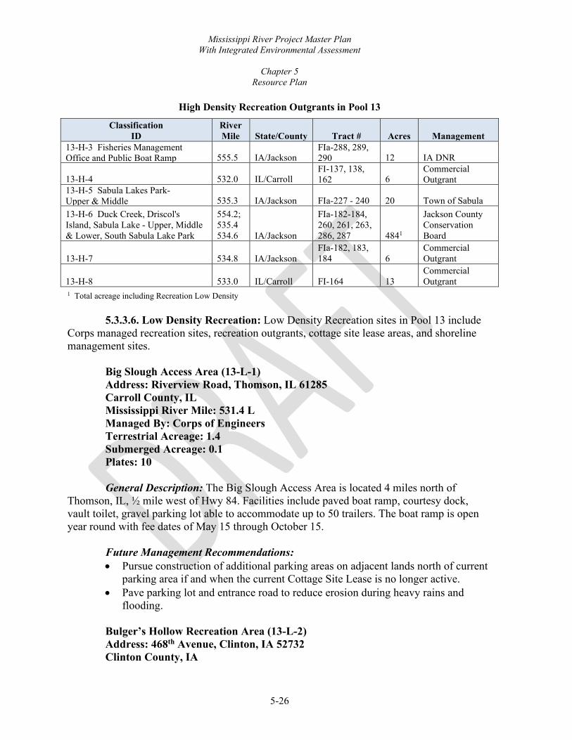
Mississippi River Project Master Plan With Integrated Environmental Assessment
Chapter 5
Resource Plan
5-26
High Density Recreation Outgrants in Pool 13
Classification ID
River Mile State/County Tract # Acres Management
13-H-3 Fisheries Management Office and Public Boat Ramp 555.5 IA/Jackson
FIa-288, 289, 290 12 IA DNR
13-H-4 532.0 IL/Carroll FI-137, 138, 162 6
Commercial Outgrant
13-H-5 Sabula Lakes Park- Upper & Middle 535.3 IA/Jackson FIa-227 - 240 20 Town of Sabula 13-H-6 Duck Creek, Driscol's Island, Sabula Lake - Upper, Middle & Lower, South Sabula Lake Park
554.2; 535.4 534.6 IA/Jackson
FIa-182-184, 260, 261, 263, 286, 287 4841
Jackson County Conservation Board
13-H-7 534.8 IA/Jackson FIa-182, 183, 184 6
Commercial Outgrant
13-H-8 533.0 IL/Carroll FI-164 13 Commercial Outgrant
1 Total acreage including Recreation Low Density
5.3.3.6. Low Density Recreation: Low Density Recreation sites in Pool 13 include Corps managed recreation sites, recreation outgrants, cottage site lease areas, and shoreline management sites.
Big Slough Access Area (13-L-1) Address: Riverview Road, Thomson, IL 61285 Carroll County, IL Mississippi River Mile: 531.4 L Managed By: Corps of Engineers Terrestrial Acreage: 1.4 Submerged Acreage: 0.1 Plates: 10
General Description: The Big Slough Access Area is located 4 miles north of
Thomson, IL, ½ mile west of Hwy 84. Facilities include paved boat ramp, courtesy dock, vault toilet, gravel parking lot able to accommodate up to 50 trailers. The boat ramp is open year round with fee dates of May 15 through October 15.
Future Management Recommendations: • Pursue construction of additional parking areas on adjacent lands north of current
parking area if and when the current Cottage Site Lease is no longer active. • Pave parking lot and entrance road to reduce erosion during heavy rains and
flooding.
Bulger’s Hollow Recreation Area (13-L-2) Address: 468th Avenue, Clinton, IA 52732 Clinton County, IA
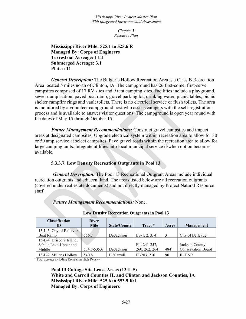
Mississippi River Project Master Plan With Integrated Environmental Assessment
Chapter 5
Resource Plan
5-27
Mississippi River Mile: 525.1 to 525.6 R Managed By: Corps of Engineers Terrestrial Acreage: 11.4 Submerged Acreage: 3.1 Plates: 11 General Description: The Bulger’s Hollow Recreation Area is a Class B Recreation
Area located 5 miles north of Clinton, IA. The campground has 26 first-come, first-serve campsites comprised of 17 RV sites and 9 tent camping sites. Facilities include a playground, sewer dump station, paved boat ramp, gravel parking lot, drinking water, picnic tables, picnic shelter campfire rings and vault toilets. There is no electrical service or flush toilets. The area is monitored by a volunteer campground host who assists campers with the self-registration process and is available to answer visitor questions. The campground is open year round with fee dates of May 15 through October 15.
Future Management Recommendations: Construct gravel campsites and impact
areas at designated campsites. Upgrade electrical system within recreation area to allow for 30 or 50 amp service at select campsites. Pave gravel roads within the recreation area to allow for large camping units. Integrate utilities into local municipal service if/when option becomes available.
5.3.3.7. Low Density Recreation Outgrants in Pool 13
General Description: The Pool 13 Recreational Outgrant Areas include individual recreation outgrants and adjacent land. The areas listed below are all recreation outgrants (covered under real estate documents) and not directly managed by Project Natural Resource staff.
Future Management Recommendations: None.
Low Density Recreation Outgrants in Pool 13
Classification ID
River Mile State/County Tract # Acres Management
13-L-3 City of Bellevue Boat Ramp 556.7 IA/Jackson LS-1, 2, 3, 4 3 City of Bellevue 13-L-4 Driscol's Island, Sabula Lake-Upper and Middle 534.8-535.6 IA/Jackson
FIa-241-257, 260, 262, 264 4841
Jackson County Conservation Board
13-L-7 Miller's Hollow 540.8 IL/Carroll FI-203, 210 90 IL DNR 1 Total acreage including Recreation High Density
Pool 13 Cottage Site Lease Areas (13-L-5) White and Carroll Counties IL and Clinton and Jackson Counties, IA Mississippi River Mile: 525.6 to 553.9 R/L Managed By: Corps of Engineers

Mississippi River Project Master Plan With Integrated Environmental Assessment
Chapter 5
Resource Plan
5-28
Terrestrial Acreage: 34.6 Submerged Acreage: 5.2 Plates: 8, 9, 10, and 11
General Description: The Pool 13 Cottage Site Lease Areas include cottage site
leases and adjacent lands. The cottage site leases are administered by Real Estate on behalf of the Project. Chapter 6, Special Topics, Planning Considerations, and Special Concerns, provides more information on cottage site leases.
Future Management Recommendations: None. Pool 13 Shoreline Management Sites (13-L-6) Jackson County, IA and Jo Daviess County, IL Mississippi River Mile: 555.0 to 528.3 R/L Managed By: Corps of Engineers Terrestrial Acreage: 17.5 Submerged Acreage: 24.0 Plates: 8, 9, 10, and 11
General Description: The Pool 13 Shoreline Management Sites include LDAs,
existing Shoreline Management sites outside LDAs, and adjacent lands. Chapter 6 and the SMP provide more information on Shoreline Management sites.
Future Management Recommendations: Follow the SMP for management of
permits and licenses.
5.3.3.8. Project Operations Lock & Dam 13 Area (13-O-1) Address: 4999 Lock Road, Fulton, IL 61252 Clinton County, IL Mississippi River Miles: 522.3 to 522.9 R Managed By: Corps of Engineers Terrestrial Acreage: 37.4 Submerged Acreage: 9.5 Plates: 11
General Description: The Lock & Dam 13 Area is located Fulton, IA. The complex
stretches across the river at a point where the bluffs on the Iowa side are very close to the river; islands and chutes dot the river beneath the bluffs. Eagle Point Nature Center occupies the high bluff immediately above the lock and dam. A dense group of sloughs and islands extend out from the Illinois shore. In 2004, the facility was listed in the NRHP as Lock and Dam No. 13 Historic District.

Mississippi River Project Master Plan With Integrated Environmental Assessment
Chapter 5
Resource Plan
5-29
The lock is 110 feet by 600 feet with additional provisions for an auxiliary lock. The movable dam consists of 10 submersible Tainter gates, 20-feet high by 64-feet long; and 3 submersible roller gates, 20-feet high by 100-feet long. The Tainter gates are elliptical. The dam system also includes three non-overflow earth and sand-filled dikes; two transitional dikes; and a submersible earth and sand-filled dike.
The Lock & Dam 13 Access Area is located 3 miles north of Fulton, IL, off Hwy 84. Facilities include gravel boat ramp, vault toilet, concrete and gravel parking lots, picnic shelter and observation deck which overlook the lock & dam.
Portions of the Lock & Dam 13 Area include USFWS fee title lands used through letters of permission from the agency in 1935 and 1936.
Future Management Recommendations: Move picnic shelter from Lock and Dam 13
entrance road to the recreation area near observation deck to increase usage of the shelter. Construct paved foundation for shelter to sit on. Pave access road and boat ramp. Identify USFWS fee title lands, made available under letters of permission for the construction of the lock and dam, that are no longer necessary for the operation of the Project and properly advise the USFWS.
Teeds Grove Radio Tower Site (13-O-2) 4500 115th St, Clinton, IA 52732 Clinton County, IA Managed By: Corps of Engineers Terrestrial Acreage: 4 Submerged Acreage: 0 Plates: 10
General Description: The Teeds Grove Radio Tower Site is located near Teeds
Grove, IA. The area is fenced and hosts a radio tower with associated structures. Future Management Recommendations: The radio tower and associated structures
are slated for removal as they are no longer needed for operation of the Project given changes in technology. The Corps is also pursuing disposal of the land.
5.3.3.9. Project Operations Outgrants in Pool 13: None.
5.3.4. NAVIGATION POOL 14 This pool includes 5,086 terrestrial acres and 1,722 submerged acres for a total of 6,807 Project acres. Within the total acres of Project lands there is 6,127 acres of proposed GP lands and waters associated with this MP revision. Project terrestrial acres by state include 843 acres in Illinois and 4,242 acres in Iowa.

Mississippi River Project Master Plan With Integrated Environmental Assessment
Chapter 5
Resource Plan
5-30
5.3.4.1. Environmentally Sensitive Areas Beaver Island ESA (14-E-1) Clinton County, IA Mississippi River Mile: 512.9 to 517.2 R Managed By: USFWS Savanna District Terrestrial Acreage: 887.6 Submerged Acreage: 224.0 Plates: 12
General Description: The USFWS manages Beaver Island ESA for fish and wildlife
purposes under a GP lands agreement. The Island hosts an extensive network of ridges, sloughs, oxbows and small lakes. Land cover is predominantly lowland forest, floodplain forest with minor extents of salix community, wet meadow shrub, and wet meadow classes. Tree species include silver maple, willow, cottonwood, oak, hickory, black walnut, silver maple mix, and bottomland hardwoods mix. This area has no developments.
Future Management Recommendations: Desired levels of forest management are to
actively manage 500 acres and passively manage remaining acreage. Active management to reach UMRSFSP goals and objectives will include invasive species removal, tree plantings, thinning treatments, timber harvest, and UMRR-HREP projects designed for sustainability and wildlife management purposes.
Wapsipinicon River Bottoms ESA (14-E-2) Clinton County, IA Mississippi River Mile: 506.7 to 509.6 R Managed By: USFWS Savanna District Terrestrial Acreage: 673.8 Submerged Acreage: 269.3 Plates: 13
General Description: The USFWS manages this area for fish and wildlife purposes
under a GP lands agreement. The area includes portions of the Upper Mississippi Refuge on the Iowa shoreline as well as Adams Island. The land cover is predominantly floodplain forest and, to a minor extent, wet meadow, developed, populus community, and lowland forest classes. Tree species include silver maple, cottonwood, oak, hickory, and bottomland hardwoods mix. This area has no developments.
Future Management Recommendations: Desired levels of forest management are to
actively manage 500 acres and passively manage remaining acreage. Active management to reach UMRSFSP goals and objectives will include invasive species removal, tree plantings, thinning treatments, timber harvests, and URRR-HREP projects designed for sustainability and wildlife management purposes.

Mississippi River Project Master Plan With Integrated Environmental Assessment
Chapter 5
Resource Plan
5-31
Rapids City ESA (14-E-3) Rock Island County, IL Mississippi River Miles: 496.3 to 496.5 L Managed By: Corps of Engineers Terrestrial Acreage: 0.6 Submerged Acreage: 5.1 Plates: 14
General Description: This small shoreline area is dominated by floodplain forest land
cover. This area has no developments. Future Management Recommendations: Desired levels of forest management are to
passively manage all of the acreage.
Fisherman’s Corner ESA (14-E-4) Rock Island County, IL Mississippi River Miles: 493.8 to 494.1 L Managed By: Corps of Engineers Terrestrial Acreage: 2.8 Submerged Acreage: 1.2 Plates: 14
General Description: Fisherman’s Corner ESA is a small peninsula surrounded by
recreation areas. The land cover is a mix of shallow marsh perennial, wet meadow, and floodplain forest classes. The vegetation primarily consists of willow and cattail species. This area has no developments.
Future Management Recommendations: Desired levels of forest management are to
passively manage all of the acreage.
5.3.4.2. Wildlife Management Upper Mississippi River NWFR Managed Pool 14 Areas (14-W-1) Clinton and Scott Counties, IA & Whiteside and Rock Island Counties, IL Mississippi River Mile: 502.8 to 523 R/L Managed By: USFWS Savanna District Terrestrial Acreage: 2,444.2 Submerged Acreage: 854.0 Plates: 12 to General Description: The UMRR-NWFR Managed Pool 14 Areas include all/or
portions of Johnson Creek, Sunfish/Cattail Slough, Meredosia Island, Swan Island, Hanson Slough, and Steamboat Slough. These areas are managed for fish and wildlife enhancement

Mississippi River Project Master Plan With Integrated Environmental Assessment
Chapter 5
Resource Plan
5-32
purposes under a GP lands agreement, and are within the Savanna District management of the NWFR. These areas have no developments except for some leveed areas.
The land cover is predominantly floodplain forest and, to a minor extent, wet meadow, levee, grassland, populus community, salix community, wet meadow shrub, agriculture, developed, lowland forest, and roadside classes. Tree species include silver maple, silver maple mix, willow, cottonwood, oak, hickory, and bottomland hardwoods mix.
Future Management Recommendations: Desired levels of forest management are to actively manage 700 acres and passively manage remaining acreage. Active management to reach UMRSFSP goals and objectives will include invasive species removal, tree plantings, thinning treatments, and timber harvests designed for sustainability and wildlife management purposes.
IA DNR Managed Pool 14 Areas (14-W-2) Scott County, IA Mississippi River Miles: 506.3 to 504.1 R Managed By: IA DNR Maquoketa Wildlife Unit Terrestrial Acreage: 667.1 Submerged Acreage: 91.5 Plates: 13 General Description: The IA DNR Managed Pool 14 Areas include all/or portions of
Princeton Wildlife Area. This area is managed for fish and wildlife enhancement purposes under a GP lands agreement by USFWS and by USFWS third party agreement to the IA DNR. The area is designated as a WMA by the IA DNR and public use of the area is outlined in Chapter 51 of Iowa Administrative Code 571. Developments include a pump, pump house, water control structures, dikes, boat ramps, access roads, maintenance trails, and similar development for wildlife management and public use. The land cover is predominantly floodplain forest and, to a minor extent, levee, wet meadow, populus community, salix community, wet meadow shrub, lowland forest, scrub/shrub, and developed classes. Tree species include silver maple, silver maple mix, willow, river birch, oak, and hickory. The IA DNR manages water levels within the Princeton complex with the primary goal of providing habitat for migratory birds. This management includes the annual lowering of water levels to promote the establishment of moist-soil vegetation. Established moist-soil vegetation is then flooded by raising water levels incrementally to provide food and cover for migratory birds throughout the duration of their migration. Undesirable vegetation is controlled through a variety of methods including prescribed fire, herbicide application, hand-cutting, mowing and other mechanical means. Access roads, boat

Mississippi River Project Master Plan With Integrated Environmental Assessment
Chapter 5
Resource Plan
5-33
ramps, and parking areas are maintained and resurfaced as necessary for suitable public use. Waterfowl nesting structures are maintained throughout the area.
Future Management Recommendations: Desired levels of forest management are to actively manage 300 acres and passively manage remaining acreage. Active management to reach UMRSFSP goals and objectives will include invasive species removal, tree plantings, thinning treatments, and prescribed fire designed for sustainability and wildlife management purposes.
5.3.4.3. Vegetative Management Pool 14 Vegetative Management Areas (14-V-1) Scott County, IA & Rock Island County, IL Mississippi River Mile: 493.2 to 520.6 R/L Managed By: Corps of Engineers Terrestrial Acreage: 74.0 Submerged Acreage: 197.1 Plates: 12, 14 General Description: The Project, Natural Resources Management Section manages
Pool 14 VMAs. Areas consist of shoreline, islands, and small peninsulas in Iowa and Illinois. The land cover is predominantly floodplain forest; commonly populus community, developed, and salix community; and, to a minor extent, wet meadow, roadside, and lowland forest classes. Tree species include silver maple, willow, oak, hickory, upland hardwood mix, and bottomland hardwood mix. Developments include a one-mile hiking trail, footbridge, dredge placements on Smith’s Island and private recreational structures such as docks and stairs authorized under the SMP outside of an LDA.
Future Management Recommendations: Desired levels of forest management are to
actively manage 20 acres and passively manage remaining acreage. Active management to reach UMRSFSP goals and objectives will include invasive species removal, tree plantings, thinning treatments, and timber harvests designed for sustainability and wildlife management purposes. Follow the current SMP regarding management of existing permits and licenses.
5.3.4.4. High Density Recreation: High Density Recreation sites in Pool 14 include Corps managed recreation sites and recreation outgrants.
Fisherman’s Corner North Recreation Area (14-H-1) Address: 16123-84 Rte N, Hampton, IL 61256 Rock Island County, IL Mississippi River Mile: 493.3 to 494.2 L Managed By: Corps of Engineers Terrestrial Acreage: 19.9 Submerged Acreage: 3.5

Mississippi River Project Master Plan With Integrated Environmental Assessment
Chapter 5
Resource Plan
5-34
Plates: 14
General Description: The Fisherman’s Corner North Recreation Area is a Class A Recreation Area located in Hampton, IL, just north of the Quad Cities off Illinois Highway 84. The campground features a total of 56 designated camping sites which consists of 5 tent camping sites and 51 sites suitable for large RV with 20/30/50 amperage electrical service. The sites amenities include a fire ring, picnic table, and shared water hydrant. The campground also consists of paved roads throughout the park, sewer dump station for RV campers, shower building with flushable toilets, vault toilets, playgrounds, and horseshoe pits. This campground is open from May 1 through the fourth Sunday in October.
Future Management Recommendations: Construct a group camping area to
accommodate large camping or civic groups in the property located upstream of park. Develop pathway to connect proposed group area to main campground. Upgrade shower building. Replace fee booth that has been damaged by multiple flood events. Construct full hookup volunteer sites to support daily operations and maintenance of the campground and surrounding recreation areas, as well as support Visitor Center operations. Upgrade some, if not all, campsites to full hookup. Install Wi-Fi capability if/when capability exists in the area. Upgrade the amphitheater area to better present and promote water safety and other educational information.
5.3.4.5. High Density Recreation Outgrants in Pool 14 General Description: The High Density Recreational Outgrant Areas in Pool 14
include individual recreation outgrants and adjacent land. The areas listed below are all high density recreation outgrants (covered under real estate documents) and not directly managed by Project Natural Resource staff.
Future Management Recommendations: None.
High Density Recreation Outgrants in Pool 14
Classification ID
River Mile State/County Tract # Acres Management
14-H-2 Joyce and Willow Island 519.6 IA/Clinton IaIs-125, 126 73
Clinton County Conservation Board
14-H-3 Rock Creek public use
/M i 507.6 IA/Clinton
FIa-243, 248, 269, 270 94
Clinton County Conservation Board
14-H-4 494.8 IA/Scott FIa-36, 37, 38, 39, 40 3 Commercial Outgrant
5.3.4.6. Low Density Recreation: Low Density Recreation sites in Pool 14 include
Corps managed recreation sites, recreation outgrants, cottage site lease areas, and shoreline management sites.

Mississippi River Project Master Plan With Integrated Environmental Assessment
Chapter 5
Resource Plan
5-35
Cattail Slough Recreation Area (14-L-1) Address: Ebson Road, Fulton, IL 61252 Whiteside County, IL Mississippi River Mile: 517.7 L Managed By: Corps of Engineers Terrestrial Acreage: 4.8 Submerged Acreage: 0.6 Plates: 12
General Description: The Cattail Slough Recreation Area is located ¼ mile southwest
of Fulton, IL, off Hwy 84. Facilities include paved boat ramp, courtesy dock, vault toilet, and a gravel parking lot able to accommodate up to 30 trailers. The boat ramp is open year round with fee dates of May 15 through October 15.
Future Management Recommendations: Pave parking lot to reduce daily and post-
flood event maintenance.
5.3.4.7. Low Density Recreation Outgrants in Pool 14 General Description: The Pool 14 Recreational Outgrant Areas include individual
recreation outgrants and adjacent land. The areas listed below are all recreation outgrants (covered under real estate documents) and not directly managed by Project Natural Resource staff.
Future Management Recommendations: None.
Low Density Recreation Outgrants in Pool 14
Classification ID
River Mile State/County Tract #
Acres Management
14-L-4 Rapids City Boat Ramp/Bike Path 496.6 IL/Rock Island FI-52 6 Village of Rapids City 14-L-3 The Great River Tug Site 497.4 IL/Rock Island
FI-80, 81, 82, 83 4 Village of Port Byron
14-L-2 Camanche Municipal Boat Ramp 510.7 IA/Clinton FIa-323 2 Town of Camanche
Pool 14 Cottage Site Lease Areas (14-L-5) Scott and Clinton Counties, IA and Rock Island County, IL Mississippi River Mile: 494.0 to 509.2 R/L Managed By: Corps of Engineers Terrestrial Acreage: 59.0 Submerged Acreage: 23.3 Plates: 13, 14

Mississippi River Project Master Plan With Integrated Environmental Assessment
Chapter 5
Resource Plan
5-36
General Description: The Pool 14 Cottage Site Lease Areas include cottage site leases and adjacent lands. The cottage site leases are administered by Real Estate on behalf of the Project. Chapter 6, Special Topics, Planning Considerations, and Special Concerns, provides more information on cottage site leases.
Future Management Recommendations: None.
Pool 14 Shoreline Management Sites (13-L-6) Scott County, IA and Rock Island County, IL Mississippi River Mile: 497.0 and 501.2 R/L Managed By: Corps of Engineers Terrestrial Acreage: 1.8 Submerged Acreage: 3.0 Plate: 14
General Description: The Pool 14 Shoreline Management Sites include LDAs,
existing Shoreline Management sites outside LDAs, and adjacent lands. Chapter 6 and the SMP provide more information on Shoreline Management sites.
Future Management Recommendations: Follow the SMP for management of
permits and licenses.
Pool 14 Dispersed Recreation Site (14-L-7) Whiteside County, IL Mississippi River Mile: 521.1 L Managed By: Corps of Engineers Terrestrial Acreage: 0.8 Submerged Acreage: 2.9 Plates: 12 General Description: The Pool 14 Dispersed Recreation Site is a small and narrow
shoreline area designated for dispersed recreation. Fishing and bird watching are examples of dispersed recreation.
Future Management Recommendations: No future developments are planned for
this area. Land surveying is planned to determine the extent of Project land ownership along the shoreline.
5.3.4.8. Project Operations
Fulton Levee and Drainage District Right of Way (14-O-1) Whiteside County, IL Mississippi River Miles: 517.4 to 517.7 L Managed By: Corps of Engineers and Fulton Levee District

Mississippi River Project Master Plan With Integrated Environmental Assessment
Chapter 5
Resource Plan
5-37
Terrestrial Acreage: 6.3 Submerged Acreage: 0 Plates: 12
General Description: The area is comprised mainly of maintained levee right of way
for Fulton Levee and Drainage District. Future Management Recommendations: Continued maintenance by levee district
per authorizations. Locks & Dam 14 Area (14-O-4) Address: 25549-182nd Street, Pleasant Valley, IA 52767 Scott County, IA Mississippi River Mile: 493.4 Managed By: Corps of Engineers Terrestrial Acreage: 23.2 Submerged Acreage: 0.9 Plates: 14
General Description: The Locks & Dam 14 Area is located 4 miles below LeClaire,
IA, and 3.6 miles below the head of the notorious, rock-bedded, Rock Island Rapids. The site includes the Project Office, the LeClaire Base, Locks and Dam 14, and Locks and Dam 14 Recreation Area. The LeClaire Lock and the remains of the LeClaire Lateral Canal, built in 1921-1924 to bypass this treacherous stretch of river, are located along the Iowa shore. In 2004, the facility was listed in the NRHP as Lock and Dam No. 14 Historic District. The main lock’s dimensions are 110 by 600 feet. The dimensions of the LeClaire Lock, which is used as an auxiliary lock, are 80 by 320 feet, with a low-water depth of 8 feet at the upper sill and 7 feet at the lower sill. The movable dam has 13 non-submersible Tainter gates (20 feet high by 60 feet long) and 4 submersible roller gates (20 feet high by 100 feet long). The dam system also includes an earth and sand-filled dike. The area includes the LeClaire Base, which is a service base for the maintenance of the Project, along with associated shoreline just upstream. The Project Office is also location within the site. The Project Office and most of the nearby office parking and associated landscaping lies on State of Iowa owned land. This land is utilized under the Government’s paramount easement for navigation as noted in the Corps’ LeClaire Base Master Plan from April 1997. Future Management Recommendations are noted in the LeClaire Base Master Plan.
The Locks & Dam 14 Recreation Area is located just down river of LeClaire, IA, off Hwy 67. Facilities include small prairie planting areas, artificial bald eagle perching

Mississippi River Project Master Plan With Integrated Environmental Assessment
Chapter 5
Resource Plan
5-38
structures, reservable picnic shelters, waterborne toilets, vault toilets, and footbridge. The boardwalk is a prime location for fishing and wildlife viewing. Lock and Dam 14 is a prime destination for eagle viewing during the colder winter months. Visitors can cross the LeClaire Lock to access the remainder of the recreation area. A footbridge provides access to Smiths Island, which includes a National Recreation Trail. The parking lot serving the entire public area and boat launch into upper Pool 15 is entirely on State of Iowa owned land and jointly managed by the IA DNR and Corps though a written agreement between the agencies.
Future Management Recommendations: An improvement to the foundation of the boardwalk is necessary in some locations to ensure boardwalk can safely be traversed and access to Smith’s Island remains open. Pave parking area. Develop a designated trail or sidewalk for the public to traverse from boardwalk to Smith’s Island trail and Lock 14 overlook structure.
5.3.4.9. Project Operations Outgrants in Pool 14
General Description: The Project Operations Outgrant Areas in Pool 14 include individual recreation outgrants and adjacent land. The areas listed below are all outgrants (covered under real estate documents) and not directly managed by Project Natural Resource staff.
Future Management Recommendations: None.
Project Operations Outgrants in Pool 14
Classification ID River Mile State/County Tract # Acres Management 14-O-2 510.5 IA/Clinton FIa-323 22.9 Municipal Infrastructure 14-O-3 498.3 IA/Scott FIa-121 3.0 Barge Terminal
5.3.5. NAVIGATION POOL 15
This pool includes seven terrestrial acres and two submerged acres for a total of nine acres of federal lands acquired for the Project. Terrestrial acres by state include seven acres in Illinois.
5.3.5.1. Low Density Recreation: Fisherman’s Corner South Recreation Area (15-L-1) Rock Island County, IL Mississippi River Mile: 493.3 L Managed By: Corps of Engineers Terrestrial Acreage: 2.7 Submerged Acreage: 0.2 Plates: 14, 15

Mississippi River Project Master Plan With Integrated Environmental Assessment
Chapter 5
Resource Plan
5-39
General Description: The Fisherman’s Corner South Recreation Area is located in Hampton, IL, just north of the Quad Cities off Illinois Highway 84. This area is popular for bank fishing and wildlife viewing. Facilities include fire rings, gravel parking lot, vault toilet, picnic tables and water hydrant. The area is open year-round.
Future Management Recommendations: Move vault toilet closer to the river where
activities occur. Pave road and parking area. Construct playground equipment and impact zone. Construct picnic shelter.
5.3.5.2. Project Operations
Locks & Dam 15 Area (15-O-1) Visitor Center Address: Building 328, Arsenal Island, Rock Island, IL 61204 Rock Island County, IL Mississippi River Miles: 482.8 to 483.2 L Managed By: Corps of Engineers Terrestrial Acreage: 4.8 Submerged Acreage: 1.8 Plates: 15, 16
General Description: The Locks & Dam 15 Area is located in Rock Island, IL. It was
the first dam of the 9-foot channel project built by the Corps. The complex stretches across the river at one of its narrowest points at the foot of the Rock Island Rapids. The complex extends from the northwest tip of the Army’s Arsenal Island on the Illinois side, to a small area of flat-bottom land on the Iowa side. A roadway and railroad bridge, joining Davenport and Rock Island, spans the site. In 2004, the facility was listed in the NRHP as Lock and Dam No. 15 Historic District. The main lock is 110 by 600 feet long and the auxiliary lock is 110 by 360 feet. The 1,203-foot-long movable dam is the largest roller dam in the world consisting of 11 non-submersible 100-foot-long roller gates. The Mississippi River Visitor Center overlooks Locks & Dam 15 on Arsenal Island in Rock Island, IL. The Center gives visitors an excellent opportunity to view towboats and the locking process. The second floor of the Center is a great place to observe the river traffic from either indoors or outdoors on the observation deck. The facility offers several educational displays including a river floor map, an aquarium with native Mississippi River fish, and a mounted Bald Eagle. Facilities include a movie theater, gift shop, and exhibit area. The Visitor Center is ADA accessible. All services are free of charge to the public. Park Rangers and volunteers staff this facility.
Future Management Recommendations: Construct a multi-use classroom, with office space for Natural Resource Management (NRM) and Lock and Dam staff, that is used for interpretative and education programs while providing additional meeting space. Upgrade

Mississippi River Project Master Plan With Integrated Environmental Assessment
Chapter 5
Resource Plan
5-40
audio/visual room in Visitor Center with new technology and achieve ADA compliance. Redesign and replace current flat roof to reduce leaking during winter. Redesign parking areas to designate specific visitor center parking areas from employee/contractor parking. Work with Rock Island Arsenal to redesign Davenport gate to get visitor center outside MEVA. See Chapter 6, Special Topics, Planning Considerations and Special Concern, for additional Visitor Center recommendations.
5.3.6. NAVIGATION POOL 16
This pool includes 5,315 terrestrial acres and 2,162 submerged acres for a total of 7,477 Project acres. Within the total acres of Project lands there are 6,553 acres of proposed GP lands and waters associated with this MP revision. Project terrestrial acres by state include 4,027 acres in Illinois and 1,288 acres in Iowa.
5.3.6.1. Environmentally Sensitive Areas Milan Bottoms ESA (16-E-1) Rock Island County, IL Mississippi River Mile: 476.7 to 478 L Managed By: IL DNR Terrestrial Acreage: 421.1 Submerged Acreage: 112.0 Plates: 16
General Description: Milan Bottoms ESA is managed for fish and wildlife
enhancement purposes under a GP lands agreement by USFWS third party agreement to the IL DNR. The acreage is a large terrestrial, riparian zone with comprised of ridge and swale topography with backwater lakes. Land cover is predominantly floodplain forest and, to a minor extent, salix and populus community classes. The landform includes ridge and swale topography with frequent backwater marsh and wetland areas. Tree species include silver maple, cottonwood, oak, hickory, and bottomland hardwoods mix. This area has a utility line but no other developments.
Future Management Recommendations: Desired levels of forest management are to
passively manage all of the acreage.
5.3.6.2. Wildlife Management IL DNR Managed Pool 16 Areas (16-W-1) Rock Island County, IL Mississippi River Mile: 458.8 to 476.7 L Managed By: IL DNR Terrestrial Acreage: 3,410.8 Submerged Acreage: 1,414.6

Mississippi River Project Master Plan With Integrated Environmental Assessment
Chapter 5
Resource Plan
5-41
Plates: 16 to 18 General Description: The IL DNR Managed Pool 16 Areas include all/or portions of
Milan Bottoms, Smith Island, Andalusia Island, Martin Island, Scisco Slough, Dead Slough, and Drury Slough. This area is managed for fish and wildlife enhancement purposes under a GP lands agreement by USFWS third party agreement to the IL DNR. Developments include a HREP project, access roads, water control structures, pump station, and maintenance trails. The land cover is predominantly floodplain forest; commonly salix community, populus community, wet meadow, sand bar; and, to a minor extent, wet meadow shrub, mudflat, lowland forest, and developed classes. Tree species include silver maple, silver maple mix, oak, hickory, cottonwood, and bottomland hardwoods mix.
Future Management Recommendations: Desired levels of forest management are to actively manage 500 acres and passively manage remaining acreage. Active management to reach UMRSFSP goals and objectives will include invasive species removal, tree plantings, and thinning treatments designed for sustainability and wildlife management purposes.
IA DNR Managed Pool 16 Areas (16-W-2) Muscatine County, IA Mississippi River Mile: 456.6 to 462.4 R/L Managed By: IA DNR Terrestrial Acreage: 673.6 Submerged Acreage: 509.3 Plates: 18 General Description: The IA DNR Managed Pool 16 Areas include all/or portions of
Wyoming Slough, Geneva Island, and Hog Island. This area is managed for fish and wildlife enhancement purposes under a GP lands agreement by USFWS and by USFWS third party agreement to the IA DNR. The area is designated as a WMA by the IA DNR and public use of the area is outlined in Chapter 51 of Iowa Administrative Code 571. These areas have no developments. The land cover is predominantly floodplain forest with a mix of sand bar, salix community, wet meadow and wet meadow shrub classes. Tree species include silver maple, cottonwood, oak, hickory, and bottomland hardwoods mix.
Future Management Recommendations: Desired levels of forest management are to actively manage 400 acres and passively manage remaining acreage. Active management to reach UMRSFSP goals and objectives will include invasive species removal, tree plantings, thinning treatments, timber harvests, and UMRR-HREP projects designed for sustainability and wildlife management purposes.
5.3.6.3. Vegetative Management

Mississippi River Project Master Plan With Integrated Environmental Assessment
Chapter 5
Resource Plan
5-42
Pool 16 Vegetative Management Areas (16-V-1) Rock Island County, IA and Scott and Muscatine Counties, IA Mississippi River Mile: 457.0 to 471.7 R/L Managed By: Corps of Engineers Terrestrial Acreage: 399.7 Submerged Acreage: 53.9 Plates: 17, 18
General Description: The Project, Natural Resources Management Section manages
the Pool 16 VMAs. Areas include all/or portions of fee title lands along the shoreline of Illinois and Iowa. Developments include roads, maintenance trails, and private recreational structures such as docks and stairs authorized under the SMP outside of an LDA. The land cover is predominantly floodplain forest; commonly salix community, populus community, developed, roadside, sand bar, and lowland forest; and, to a minor extent, wet meadow shrub classes. Tree species include silver maple, willow, oak, hickory, and bottomland hardwoods mix.
Future Management Recommendations: Desired levels of forest management are to actively manage 200 acres and passively manage remaining acreage. Active management to reach UMRSFSP goals and objectives will include invasive species removal, tree plantings, and thinning treatments designed for sustainability and wildlife management purposes. Follow the current SMP regarding management of existing permits and licenses.
5.3.6.4. High Density Recreation. High Density Recreation sites in Pool 16 include Corps managed recreation sites and recreation outgrants.
Clark’s Ferry Recreation Area (16-H-1) Address: 3860 Sunset Beach, Montpelier, IA 52759 Muscatine County, IA Mississippi River Miles: 468.2 to 468.6 R Managed By: Corps of Engineers Terrestrial Acreage: 15.6 Submerged Acreage: 0.7 Plates: 17
General Description: The Clarks’ Ferry Recreation Area is a Class A Recreation Area
located off of Highway 22 to the west of Montpelier, IA. The campground features a total of 44 designated camping sites suitable for large RV with 20/30/50 amperage electrical service. The sites amenities include a fire ring, picnic table, and shared water hydrant. The campground also consists of paved roads throughout the park, sewer dump station for RV campers, shower building with flushable toilets, 2 sets of vault toilets, 2 playgrounds, 3 picnic sites, reservable picnic shelter, paved overflow parking that can accommodate 14 vehicles, ADA accessible fishing dock, 3 ADA accessible parking stalls, and gravel overflow parking

Mississippi River Project Master Plan With Integrated Environmental Assessment
Chapter 5
Resource Plan
5-43
that can accommodate 7 vehicles. There is a concrete boat ramp/launch lane with a courtesy loading dock. The paved boat ramp parking lot can accommodate 14 vehicles with trailers. This campground and boat ramp are open with fee dates from May 1 through the fourth Sunday in October.
Future Management Recommendations: Upgrade shower building. Construct full
hookup volunteer sites to support daily operations and maintenance of the campground and day use area. Expand the existing boat ramp parking lot to include additional parking stalls. Pave day use parking area. Construct overflow parking area within the campground to support passenger vehicles. Install Wi-Fi capability if/when capability exists in the area. Upgrade some, if not all, campsites to full hookup. Elevate campsites 1 and 3-7 to reduce impacts from minor flooding. Pave campsite living impact sites.
Shady Creek Recreation Area (16-H-2) Address: 3550 Hwy 22, Muscatine, IA 52761 Muscatine County, IA Mississippi River Mile: 464.6 to 465.3 R Managed By: Corps of Engineers Terrestrial Acreage: 42.6 Submerged Acreage: 1.0 Plates: 17, 18
General Description: The Shady Creek Recreation Area is a Class A Recreation Area
located off Highway 22 four miles east of Fairport, IA. The campground features a total of 53 designated camping sites suitable for large RV with 20/30/50 amperage electrical service. The sites amenities include a fire ring, picnic table, and shared water hydrant. The campground also consists of paved roads throughout the park, sewer dump station for RV campers, shower building with flushable toilets, flushable toilets in day-use area, 2 sets of vault toilets, 2 playgrounds, 5 picnic sites, reservable picnic shelter, a hiking trail that is 1.1 miles long at the north edge of the campground, and paved overflow parking that can accommodate 23 vehicles. There is a concrete boat ramp/launch lane with a courtesy loading dock. The paved boat ramp parking lot can accommodate 22 vehicles with trailers. This campground and boat ramp are open year round with fee dates from May 1 through the fourth Sunday in October.
Future Management Recommendations: Construct additional paved day use and boat ramp trailer parking. Construct additional picnic sites in day use area. Reconstruct the entrance into the park to increase distance from railroad tracks and reduce flooding in the fee booth; construct new fee booth in new location. Construct full hookup volunteer sites to support daily operations and maintenance of recreation area. Integrate utilities into local municipal service if/when option becomes available. Upgrade some, if not all, campsites to full hookup. Install Wi-Fi capability if/when capability exists in the area. Dredge boat ramp to increase depth and access for boats. Construct group camping area within current campground or day use area. Construct an office, garage, and storage facilities within area to support the Muscatine Ranger Station; permanent location for staff instead of renting facilities. Establish
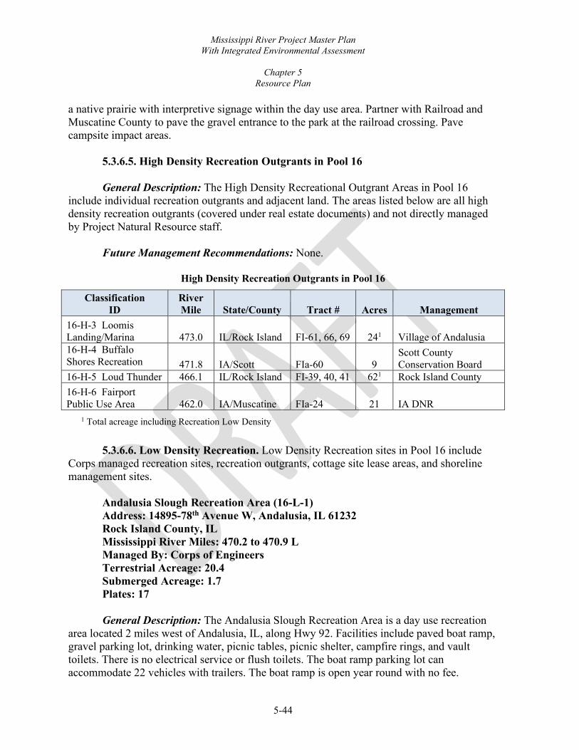
Mississippi River Project Master Plan With Integrated Environmental Assessment
Chapter 5
Resource Plan
5-44
a native prairie with interpretive signage within the day use area. Partner with Railroad and Muscatine County to pave the gravel entrance to the park at the railroad crossing. Pave campsite impact areas.
5.3.6.5. High Density Recreation Outgrants in Pool 16 General Description: The High Density Recreational Outgrant Areas in Pool 16
include individual recreation outgrants and adjacent land. The areas listed below are all high density recreation outgrants (covered under real estate documents) and not directly managed by Project Natural Resource staff.
Future Management Recommendations: None.
High Density Recreation Outgrants in Pool 16
Classification ID
River Mile State/County Tract # Acres Management
16-H-3 Loomis Landing/Marina 473.0 IL/Rock Island FI-61, 66, 69 241 Village of Andalusia 16-H-4 Buffalo Shores Recreation A
471.8 IA/Scott FIa-60 9 Scott County Conservation Board
16-H-5 Loud Thunder 466.1 IL/Rock Island FI-39, 40, 41 621 Rock Island County 16-H-6 Fairport Public Use Area 462.0 IA/Muscatine FIa-24 21 IA DNR
1 Total acreage including Recreation Low Density
5.3.6.6. Low Density Recreation. Low Density Recreation sites in Pool 16 include
Corps managed recreation sites, recreation outgrants, cottage site lease areas, and shoreline management sites.
Andalusia Slough Recreation Area (16-L-1) Address: 14895-78th Avenue W, Andalusia, IL 61232 Rock Island County, IL Mississippi River Miles: 470.2 to 470.9 L Managed By: Corps of Engineers Terrestrial Acreage: 20.4 Submerged Acreage: 1.7 Plates: 17
General Description: The Andalusia Slough Recreation Area is a day use recreation
area located 2 miles west of Andalusia, IL, along Hwy 92. Facilities include paved boat ramp, gravel parking lot, drinking water, picnic tables, picnic shelter, campfire rings, and vault toilets. There is no electrical service or flush toilets. The boat ramp parking lot can accommodate 22 vehicles with trailers. The boat ramp is open year round with no fee.

Mississippi River Project Master Plan With Integrated Environmental Assessment
Chapter 5
Resource Plan
5-45
Future Management Recommendations: Remove metal vault toilets and replace with concrete vault toilets. Add storage shed/building for lawn mower and hand tools for staff and volunteers.
5.3.6.7. Low Density Recreation Outgrants in Pool 16 General Description: The Pool 16 Recreational Outgrant Areas include individual
recreation outgrants and adjacent land. The areas listed below are all recreation outgrants (covered under real estate documents) and not directly managed by Project Natural Resource staff.
Future Management Recommendations: None.
Low Density Recreation Outgrants in Pool 16
Classification ID
River Mile State/County Tract # Acres Management
16-L-2 462.8 IA/Muscatine FIa-25 2 Quasi Public Outgrant 16-L-5 Loomis Landing/Marina 472.4 IL/Rock Island FI-61 241 Village of Andalusia 16-L-6 Loud Thunder 466.1 IL/Rock Island FI-39, 40, 41 621 Rock Island County
1 Total acreage including Recreation High Density
Pool 16 Cottage Site Lease Areas (16-L-3) Scott and Muscatine Counties, IA and Rock Island County, IL Mississippi River Mile: 458.5 to 471.4 R/L Managed By: Corps of Engineers Terrestrial Acreage: 77.6 Submerged Acreage: 11.6 Plates: 17, 18
General Description: The Pool 16 Cottage Site Lease Areas include cottage site leases
and adjacent lands. The cottage site leases are administered by Real Estate on behalf of the Project. Chapter 6, Special Topics, Planning Considerations, and Special Concerns, provides more information on cottage site leases.
Future Management Recommendations: None.
Pool 16 Shoreline Management Sites (16-L-4) Muscatine County, IA and Rock Island County, IL Mississippi River Mile: 458.6 and 466.0 R/L Managed By: Corps of Engineers Terrestrial Acreage: 38.2 Submerged Acreage: 5.2

Mississippi River Project Master Plan With Integrated Environmental Assessment
Chapter 5
Resource Plan
5-46
Plates: 17 and 18 General Description: The Pool 16 Shoreline Management Sites include LDAs,
existing Shoreline Management sites outside LDAs, and adjacent lands. Chapter 6 and the SMP provide more information on Shoreline Management sites.
Future Management Recommendations: Follow the SMP for management of permits
and licenses.
5.3.6.8. Project Operations Buffalo Dredged Material Placement Site (16-O-2) Scott County, IA Mississippi River Miles: 471.2 to 471.5 R Managed By: Corps of Engineers Terrestrial Acreage: 33.2 Submerged Acreage: 0.0 Plates: 17
General Description: This area is downstream from Buffalo, IA, and accessible from
Highway 22. Dredged material from the channel is placed on the site periodically. The land cover is primarily wet meadow and sand.
Future Management Recommendations: Continued management as noted in Navigation/dredged material planning.
Hershey Chute Dredged Material Beneficial Use (16-O-4) Rock Island County, IA Mississippi River Miles: 461.1 to 461.3 R Managed By: Corps of Engineers Terrestrial Acreage: 9.0 Submerged Acreage: 0 Plates: 18
General Description: This shoreline area is downstream from Illinois City, IL, and
accessible on country road from Highway 92. The site was acquired as part of the Hershey Chute DMMP. Dredged material from the channel is placed on the site periodically. Management of the site allows for access for removal and beneficial use of the material by the public and local government. The land cover is typically managed through use of an agricultural lease. In years where the site cannot be planted the land cover is wet meadow.
Future Management Recommendations: Continued management as noted in the
Hershey Chute DMMP and other Navigation/dredged material planning.
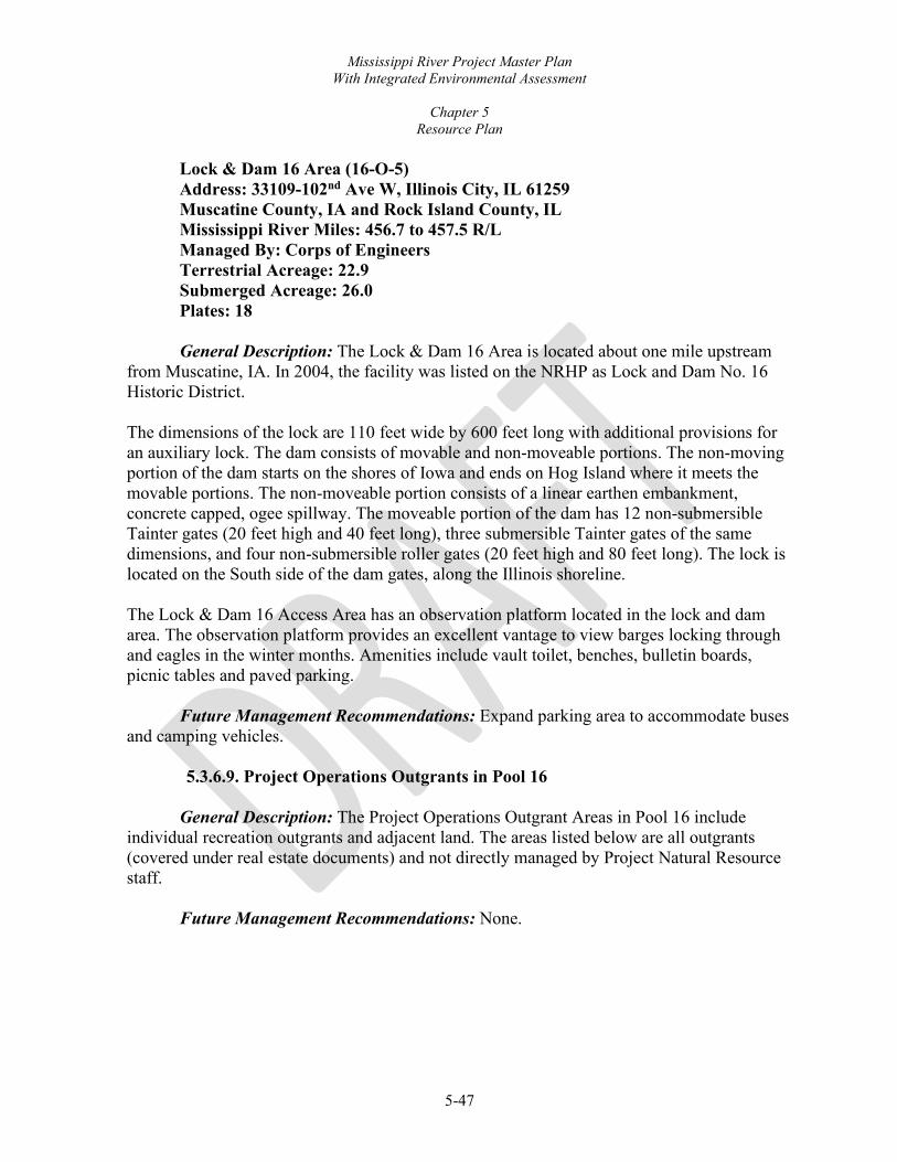
Mississippi River Project Master Plan With Integrated Environmental Assessment
Chapter 5
Resource Plan
5-47
Lock & Dam 16 Area (16-O-5) Address: 33109-102nd Ave W, Illinois City, IL 61259 Muscatine County, IA and Rock Island County, IL Mississippi River Miles: 456.7 to 457.5 R/L Managed By: Corps of Engineers Terrestrial Acreage: 22.9 Submerged Acreage: 26.0 Plates: 18
General Description: The Lock & Dam 16 Area is located about one mile upstream
from Muscatine, IA. In 2004, the facility was listed on the NRHP as Lock and Dam No. 16 Historic District. The dimensions of the lock are 110 feet wide by 600 feet long with additional provisions for an auxiliary lock. The dam consists of movable and non-moveable portions. The non-moving portion of the dam starts on the shores of Iowa and ends on Hog Island where it meets the movable portions. The non-moveable portion consists of a linear earthen embankment, concrete capped, ogee spillway. The moveable portion of the dam has 12 non-submersible Tainter gates (20 feet high and 40 feet long), three submersible Tainter gates of the same dimensions, and four non-submersible roller gates (20 feet high and 80 feet long). The lock is located on the South side of the dam gates, along the Illinois shoreline. The Lock & Dam 16 Access Area has an observation platform located in the lock and dam area. The observation platform provides an excellent vantage to view barges locking through and eagles in the winter months. Amenities include vault toilet, benches, bulletin boards, picnic tables and paved parking.
Future Management Recommendations: Expand parking area to accommodate buses and camping vehicles.
5.3.6.9. Project Operations Outgrants in Pool 16
General Description: The Project Operations Outgrant Areas in Pool 16 include individual recreation outgrants and adjacent land. The areas listed below are all outgrants (covered under real estate documents) and not directly managed by Project Natural Resource staff.
Future Management Recommendations: None.

Mississippi River Project Master Plan With Integrated Environmental Assessment
Chapter 5
Resource Plan
5-48
Project Operations Outgrants in Pool 16
Classification ID River Mile State/County Tract # Acres Management 16-O-1 472.3-473.7 IL/Rock Island FI-61, 66, 70 18.0 Municipal Infrastructure 16-O-3 469.8 IA/Scott FIa-51 10.0 Barge Terminal 16-O-6 468.6-470.9 IL/Rock Island FI-42-48 20.4 Road ROW
5.3.7. NAVIGATION POOL 17
This pool includes 8,624 terrestrial acres and 3,146 submerged acres for a total of 11,770 Project acres. Within the total acres of Project lands there is 11,536 acres of proposed GP lands and waters associated with this MP revision. Project terrestrial acres by state include 2,618 acres in Illinois and 6,006 acres in Iowa.
5.3.7.1. Environmentally Sensitive Areas Port Louisa NWR-Big Timber Division ESA (17-E-1) Louisa County, IA Mississippi River Mile: 443.0 to 446.8 R Managed By: USFWS Port Louisa NWR Terrestrial Acreage: 850.0 Submerged Acreage: 362.7 Plates: 20
General Description: The Big Timber Division ESA is managed for fish and wildlife
enhancement purposes under a GP lands agreement by USFWS and is within the Port Louisa NWR. This area is a large terrestrial riparian ecosystem with diverse features such as: island lakes, large backwater sloughs, and wetland complexes. The land cover is predominantly floodplain forest; commonly salix and populus community; and, to a minor extent, upland forest. Tree species include silver maple, American sycamore (Platanus occidentalis), oak, hickory, willow, and bottomland hardwoods mix. Developments include UMRR-HREP project, public boat ramp, parking lot, and kiosk. Primary public uses are fishing and hunting.
Future Management Recommendations: Desired levels of forest management are to
actively manage 250 acres and passively manage remaining acreage. Active management to reach UMRSFSP goals and objectives will include invasive species removal, tree plantings, thinning treatments, and timber harvest designed for sustainability and wildlife management purposes.
Port Louisa NWR-Louisa Division ESA (17-E-2) Louisa County, IA Mississippi River Mile: 438.2 to 441.7 R Managed By: USFWS Port Louisa NWR Terrestrial Acreage: 1,917.8
I I

Mississippi River Project Master Plan With Integrated Environmental Assessment
Chapter 5
Resource Plan
5-49
Submerged Acreage: 634.2 Plates: 20, 21
General Description: This area is managed for fish and wildlife enhancement
purposes under a GP lands agreement by USFWS. Area 17-E-2 is the up-stream portion of the Port Louisa ESA riparian complex and is adjacent to the river’s channel. The land cover is predominantly floodplain forest; commonly wet meadow, salix community, levee, roadside, agricultural fields, and lowland forest. Minor vegetation compositions are wet meadow shrub, populus community, mudflat, and upland forest. Tree species include silver maple, cottonwood, willow, river birch, oak, hickory, and bottomland hardwoods mix. Developments include UMRR-HREP projects, 4 public boat ramps (Schafer’s Access, Sand Run Access, Burris Ditch Access, and Toolesboro Access), 2 public boat docks, water control structures, 2.5 miles of public access roads, 6 public parking lots, 5.2 miles of levee, 3 concrete spillways, and several maintenance trails. USFWS manages approximately 800 acres of moist soil units for waterfowl migration on the Louisa Division and conducts prescribed burns to manage grassland habitat. There is a system of ditches and water control structures for managing water levels on the division. One boat ramp, a paddling launch, 4 parking lots, an accessible fishing pier and observation deck, a hiking trail, information kiosks, and seasonal auto tour are maintained by the USFWS also. The area at the inlet structure receives moderate public use, primarily for fishing.
Future Management Recommendations: Desired levels of forest management are to actively manage 400 acres and passively manage remaining acreage. Active management to reach UMRSFSP goals and objectives will include invasive species removal, tree plantings, thinning treatments, and timber harvest designed for sustainability and wildlife management purposes.
Lake Odessa Wildlife Management Area ESA (17-E-3) Louisa County, IA River Mile: 434.1 to 439.5 R Managed By: IA DNR Terrestrial Acreage: 2,583.2 Submerged Acreage: 1,479.9 Plates: 20, 21
General Description: Lake Odessa WMA ESA is managed for fish and wildlife
enhancement purposes under a GP lands agreement by USFWS third party agreement to the IA DNR. The area is designated as a WMA by the IA DNR and public use of the area is outlined in Chapter 51 of Iowa Administrative Code 571. The landscape feature encompasses former levee and drainage district area bordered by a levee embankment along the main channels. It is a patchwork of terrestrial areas along with backwater lakes, sloughs, and small islands. The land cover is predominantly floodplain forest and salix community; commonly wet meadow, levee, lowland forest, roadside, populus community; and, to a minor extent,

Mississippi River Project Master Plan With Integrated Environmental Assessment
Chapter 5
Resource Plan
5-50
sand bar, developed, and pasture classes. Tree species include silver maple, cottonwood, willow, river birch, oak, hickory, and bottomland hardwoods mix. The IA DNR manages water levels within the Odessa complex with the primary goal of providing habitat for migratory birds. This management includes the annual lowering of water levels to promote the establishment of moist-soil vegetation. Established moist-soil vegetation is then flooded by raising water levels incrementally to provide food and cover for migratory birds throughout the duration of their migration. Migratory bird management also includes a 45 acre moist-soil unit where vegetation is manipulated or row crops are planted and later flooded by the installation and operation of a portable water pump. Twenty acres of agricultural food plots are established annually using conventional farming methods in several small fields. Undesirable vegetation is controlled through a variety of methods including prescribed fire, herbicide application, hand-cutting, mowing and other mechanical means. Access roads, boat ramps, and parking areas are maintained and resurfaced as necessary for suitable public use. Waterfowl nesting structures are maintained throughout the area.
Future Management Recommendations: Desired levels of forest management are to actively manage 500 acres and passively manage remaining acreage. Active management to reach UMRSFSP goals and objectives will include invasive species removal, tree plantings, and thinning treatments designed for sustainability and wildlife management purposes.
5.3.7.2. Wildlife Management Port Louisa NWR Area (17-W-1) Louisa County, IA Mississippi River Mile: 437.1 to 443.3 R Managed By: USFWS Port Louisa NWR Terrestrial Acreage: 419.0 Submerged Acreage: 138.8 Plates: 20, 21 General Description: The Port Louisa NWR Managed Areas include all/or portions of
Turkey Island and Ramsey Island. These areas are managed for fish and wildlife enhancement purposes under a GP lands agreement by USFWS, and are within the Big Timber Division of Port Louisa NWR. Developments include an EMP-HREP project, public boat ramp, parking lot, and kiosk. Primary public uses are fishing and hunting.
The land cover is predominantly floodplain forest and, to a minor extent, salix community, wet meadow shrub, and sand bar classes. Tree species include silver maple, sycamore, oak, hickory, willow, and bottomland hardwoods mix.

Mississippi River Project Master Plan With Integrated Environmental Assessment
Chapter 5
Resource Plan
5-51
Future Management Recommendations: Desired levels of forest management are to actively manage 300 acres and passively manage remaining acreage. Active management to reach UMRSFSP goals and objectives will include invasive species removal, tree plantings, thinning treatments, and timber harvest designed for sustainability and wildlife management purposes.
IL DNR Managed Pool 17 Areas (17-W-2) Rock Island and Mercer Counties, IL Mississippi River Miles: 437.5 to 452.1 L Managed By: IL DNR Terrestrial Acreage: 2,521.2 Submerged Acreage: 492.7 Plates: 21 to 23
General Description: The IL DNR Managed Pool 17 Areas include all/or portions of
Blanchard Island, Bass Island, Barkis Island, Bogus Chute, Jonas Johnson Island, Bell Island, Coleman Island, Little Bogus Island, and Hail Island. This area is managed for fish and wildlife enhancement purposes under a GP lands agreement by USFWS third party agreement to the IL DNR. These areas have no developments.
The land cover is predominantly floodplain forest, and, to a minor extent, populus community, salix community, wet meadow shrub, sand bar, and wet meadow classes. Tree species include silver maple, silver maple mix, willow, and bottomland hardwood mix.
Future Management Recommendations: Desired levels of forest management are to
actively manage 750 acres and passively manage remaining acreage. Active management to reach UMRSFSP goals and objectives will include invasive species removal, tree plantings, thinning treatments, and timber harvest designed for sustainability and wildlife management purposes.
IA DNR Managed Pool 17 Areas (17-W-3) Louisa County, IA Mississippi River Mile: 447.7 to 446.3 R Managed By: IA DNR Terrestrial Acreage: 126.5 Submerged Acreage: 10.2 Plates: 19, 20
General Description: The IA DNR Managed Pool 17 Areas include all/or portions of
Kilpeck Island. These areas are managed for fish and wildlife enhancement purposes under a GP lands agreement by USFWS and by USFWS third party agreement to the IA DNR. The area is designated as a WMA by the IA DNR and public use of the area is outlined in Chapter 51 of Iowa Administrative Code 571. These areas have no developments.

Mississippi River Project Master Plan With Integrated Environmental Assessment
Chapter 5
Resource Plan
5-52
The land cover is predominantly floodplain forest with some wet meadow. Tree species include silver maple, silver maple mix, willow, and bottomland hardwood mix.
Future Management Recommendations: Desired levels of forest management are to actively manage 80 acres and passively manage remaining acreage. Active management to reach UMRSFSP goals and objectives will include invasive species removal, tree plantings, thinning treatments, and timber harvest designed for sustainability and wildlife management purposes.
5.3.7.3. Vegetative Management Pool 17 Vegetative Management Area (17-V-1) Muscatine and Louisa Counties, IA Mississippi River Mile: 449.6 to 441.3 R Managed By: Corps of Engineers Terrestrial Acreage: 44.0 Submerged Acreage: 8.9 Plates: 19 to 21
General Description: The Project, Natural Resources Management Section manages
the Pool 17 VMAs. Areas include all/or portions of fee title lands along the shoreline of Iowa. These areas have no developments. The VMA are thin plot strips located along the shoreline adjacent to the channel and secondary channels. The land cover is predominantly floodplain forest with some lowland forest. Tree species include silver maple and willow.
Future Management Recommendations: Desired levels of forest management are to passively manage all of the acreage.
5.3.7.4. High Density Recreation: High Density Recreation sites in Pool 17 includes a recreation outgrant.
5.3.7.5. High Density Recreation Outgrants in Pool 17
General Description: The High Density Recreational Outgrant Areas in Pool 17 include individual recreation outgrants and adjacent land. The areas listed below are all high density recreation outgrants (covered under real estate documents) and not directly managed by Project Natural Resource staff.
Future Management Recommendations: None.

Mississippi River Project Master Plan With Integrated Environmental Assessment
Chapter 5
Resource Plan
5-53
High Density Recreation Outgrants in Pool 17
Classification ID River Mile State/County Tract # Acres Management
Snively’s Access (17-H-1) 439.0 IA/Louisa FIa-127 ET AL 971 IA DNR 1 Total acreage includes Recreation Low Density
5.3.7.6. Low Density Recreation: Low Density Recreation sites in Pool 17 include
Corps managed recreation sites, recreation outgrants, cottage site lease areas, and shoreline management sites.
Blanchard Island Recreation Area (17-L-1) Address: 34000-176th St W, New Boston, IL 61272 Rock Island County, IL Mississippi River Mile: 449.5 to 450.3 L Managed By: Corps of Engineers Terrestrial Acreage: 66.6 Submerged Acreage: 4.1 Plates: 19
General Description: The Blanchard Island Recreation Area is a Class B Recreation
Area located downstream of Muscatine on the Illinois side. The campground has 15 first-come, first-serve campsites. Facilities include sewer dump station, paved boat ramp, gravel parking lot, drinking water, picnic tables, campfire rings and vault toilets. There is no electrical service or flush toilets. The area is monitored by a volunteer campground host who assists campers with the self-registration process and is available to answer visitor questions. The campground is open year round with fee dates of May 15 through October 15.
Future Management Recommendations: Concrete 5-10 campsites and pave roads to
reduce the amount of maintenance after flood events. Remove underutilized portions of the area and campsites. Add storage shed/building for lawn mower and hand tools for staff and volunteers.
Kilpeck Landing Recreation Area (17-L-2) Address: 8314-172nd Street, Muscatine, IA 52761 Louisa County, IA Mississippi River Mile: 446.8 to 447.1 R Managed By: Corps of Engineers Terrestrial Acreage: 2.2 Submerged Acreage: 0.1 Plates: 19, 20
General Description: The Kilpeck Landing Recreation Area is located 5 miles
northeast of Grandview, IA. Facilities Include paved boat ramp, 5 picnic sites, and a gravel parking lot that can accommodate up to 20 trailers. The boat ramp is open year round.

Mississippi River Project Master Plan With Integrated Environmental Assessment
Chapter 5
Resource Plan
5-54
Future Management Recommendations: Expand current parking lot and pave the gravel lot. Install a concrete vault toilets.
5.3.7.7. Low Density Recreation Outgrants in Pool 17
General Description: The Low Density Recreational Outgrant Areas in Pool 17
include individual recreation outgrants and adjacent land. The areas listed below are all recreation outgrants (covered under real estate documents) and not directly managed by Project Natural Resource staff.
Future Management Recommendations: None.
Low Density Recreation Outgrants in Pool 17
Classification ID River Mile State/County Tract # Acres Management
Crosses Corner (17-L-3) 446.8 IL/Mercer FI-13 10 IL DNR Flaming Prairie (17-L-4) 443.0 IA/Louisa FIa-14 <1
Louisa County Conservation Board
Schaffer’s and Sand Run Access (17-L-5) 436.4–439.8 IA/Louisa FIa-127 ET AL 971 IA DNR 1 Total acreage includes Recreation High Density
Pool 17 Cottage Site Lease Area (17-L-6) Louisa County, IA Mississippi River Miles: 446.8 and 446.9 R Managed By: Corps of Engineers Terrestrial Acreage: 0.9 Submerged Acreage: 0 Plate: 20 General Description: The Pool 17 Cottage Site Lease Areas include cottage site leases
and adjacent lands. The cottage site leases are administered by Real Estate on behalf of the Project. Chapter 6, Special Topics, Planning Considerations, and Special Concerns, provides more information on cottage site leases.
Future Management Recommendations: None.
Pool 17 Shoreline Management Sites (17-L-7) Louisa County, IA Mississippi River Mile: 442.3 R Managed By: Corps of Engineers Terrestrial Acreage: 0.1 Submerged Acreage: 0.1
Mississippi River Project Master Plan With Integrated Environmental Assessment
Chapter 5
Resource Plan
5-55
Plate: 19, 20
5.3.7.8. Low Density Shoreline Management Sites in Pool 17 General Description: The Pool 17 Shoreline Management Sites include LDAs and
adjacent lands. Chapter 6 and the SMP provide more information on Shoreline Management sites.
Future Management Recommendations: Follow the SMP for management of permits
and licenses.
5.3.7.9 Project Operations Lock & Dam 17 Area (17-O-2) Address: 173 Lock & Dam Road, New Boston, IL 61272 Louisa County, IA and Mercer County, IL Mississippi River Miles: 436.8 to 437.6 R/L Managed By: Corps of Engineers Terrestrial Acreage: 23.0 Submerged Acreage: 2.9 Plates: 20, 21
General Description: The Lock & Dam 17 Area stretches across a wide portion of
river where there are several marshy islands. The lock and dam levee expands to the levee that surrounds Lake Odessa on the Iowa shore. In 2004, the facility was listed in the NRHP as Lock and Dam No. 17 Historic District. The lock is 110 feet wide by 600 feet long with additional provisions for an auxiliary lock. The movable dam has eight submersible tainter gates (20 feet high by 64 feet long) and three submersible roller gates (20 feet high by 100 feet long). The dam system also includes one non-overflow earth and sand-filled dike; two transitional dikes; and a submersible earth and sand-filled dike. Lock & Dam 17 Recreation Area is located adjacent to Lock 17 and has an observation platform located in the lock and dam area.
Future Management Recommendations: Standardize the current recreation area adjacent to Lock and Dam 17 with designated gravel or paved parking lot with designated parking stalls. Install vault toilet for visitor use in both the adjacent recreation area as well as within the Lock and Dam visitor area. Install new steel overlook structure to allow visitors access to view wildlife and commercial barge traffic transporting through Lock 17.
Bass Island Dredged Material Placement Site (17-O-3) Mercer County, IL Mississippi River Miles: 447.8 L

Mississippi River Project Master Plan With Integrated Environmental Assessment
Chapter 5
Resource Plan
5-56
Managed By: Corps of Engineers Terrestrial Acreage: 20.2 Submerged Acreage: 0 Plates: 19 General Description: This upland area is in rural Illinois downstream from Muscatine,
IA. The site was acquired as part of the Bass Island DMMP and is landward of the levee. Dredged material from the channel is placed on the site periodically. Management of the site allows for access for removal and beneficial use of the material by the public and local government.
Future Management Recommendations: Continued management as noted in the Bass
Island DMMP and other Navigation/dredged material planning.
5.3.7.10. Project Operations Outgrants in Pool 17
General Description: The Project Operations Outgrant Areas in Pool 17 include individual recreation outgrants and adjacent land. The areas listed below are all outgrants (covered under real estate documents) and not directly managed by Project Natural Resource staff.
Future Management Recommendations: None.
Project Operations Outgrants in Pool 17
Classification ID River Mile State/County Tract # Acres Management
17-O-1 442.3-449.5 IA/Louisa & Muscatine
Fia-013a, 14, 18, 19, 20, 22, 24, 28, 50, 51, 56, 57a, 57b, 58, 63, 65, 73, 75, 76, 77, 78, 79
36.2 Levee ROW
5.3.8. NAVIGATION POOL 18
This pool includes 8,367 terrestrial acres and 2,964 submerged acres for a total of 11,330 Project acres. Within the total acres of Project lands there is 10,237 acres of proposed GP lands and waters associated with this MP revision. Project terrestrial acres by state include 3,679 acres in Illinois and 4,687 acres in Iowa.
5.3.8.1. Environmentally Sensitive Areas Boston Bay ESA (18-E-1) Mercer County, IL Mississippi River Mile: 433.4 L Managed By: IL DNR Terrestrial Acreage: 8.6 Submerged Acreage: 1.1 Plates: 21, 22
I I

Mississippi River Project Master Plan With Integrated Environmental Assessment
Chapter 5
Resource Plan
5-57
General Description: Boston Bay ESA is managed for fish and wildlife enhancement purposes under a GP lands agreement by the USFWS third party agreement to the IL DNR. The plot of land is located on the channel side of the peninsula that is adjacent to Boston Bay. The land cover is predominantly floodplain forest. Tree species include silver maple and bottomland hardwoods mix. This area does not have any developments.
Future Management Recommendations: Desired levels of forest management are to
passively manage all of the acreage.
Keithsburg ESA and IL DNR Wildlife Area (18-E-2) Mercer County, IL Mississippi River Mile: 427.8 to 431.6 L Managed By: USFWS and IL DNR Terrestrial Acreage: 855.7 Submerged Acreage: 572.6 Plates: 22
General Description: Keithsburg ESA is managed by the USFWS for fish and
wildlife purposes under a GP lands agreement within the Keithsburg Division of Port Louisa Refuge and managed by IL DNR on the small shoreline upstream of the Refuge. This ESA is an extensive network of shallow back water sloughs and small lakes one half mile north of Keithsburg, Illinois. The land cover is predominantly salix community; commonly floodplain forest and levee; and, to a minor extent, lowland forest and developed classes. Tree species include silver maple, river birch, oak, hickory, and bottomland hardwoods mix. Water levels are managed on the Division to promote aquatic vegetation growth for waterfowl migration. Developments include a public boat ramp, water control structures, parking lots, kiosk, access roads, maintenance trails, and private recreational structures such as docks and stairs authorized under the SMP outside of an LDA. The primary public use for the area is fishing.
Future Management Recommendations: Desired levels of forest management are to
actively manage 350 acres and passively manage remaining acreage. Active management to reach UMRSFSP goals and objectives will include invasive species removal, tree plantings, thinning treatments, and UMRR-HREP projects designed for sustainability and wildlife management purposes. Follow the current SMP regarding management of existing permits and licenses.
Huron Island ESA (18-E-3) Des Moines County, IA Mississippi River Mile: 421.7 to 425.3 R Managed By: IA DNR Terrestrial Acreage: 1,155.6 Submerged Acreage: 261.5 Plates: 23

Mississippi River Project Master Plan With Integrated Environmental Assessment
Chapter 5
Resource Plan
5-58
General Description: Huron Island ESA is managed for fish and wildlife enhancement purposes under a GP lands agreement by USFWS and by USFWS third party agreement to the IA DNR. This area is designated as a WMA by the IA DNR and public use of the area is outlined in Chapter 51 of Iowa Administrative Code 571. The Island is located on the inside bend of the river, separated from the main land by a side channel. Its serpentine backwaters are connected to the river on the downstream segment of the property with smaller islands further downstream. The land cover is predominantly floodplain forest and, to a minor extent, populus community, wet meadow, and mud flat classes. Tree species include silver maple, river birch, oak, hickory, and bottomland hardwoods mix. Developments include UMRR-HREP project features.
Future Management Recommendations: Desired levels of forest management are to
actively manage 450 acres and passively manage remaining acreage. Active management to reach UMRSFSP goals and objectives will include invasive species removal, tree plantings, thinning treatments, timber harvests, and UMRR-HREP projects designed for sustainability and wildlife management purposes.
Big River ESA (18-E-4) Henderson County, IL Mississippi River Mile: 422.5 to 422.8 L Managed By: IL DNR and Corps of Engineers Terrestrial Acreage: 7.8 Submerged Acreage: 3.6 Plates: 23
General Description: A portion of the area is managed by the IL DNR under a
recreational lease for Putney’s Landing and the remainder Corps managed lands including 5 cottage area site lease sites. This is a small rectangular plot of land adjacent to two side channels and a back-water slough.
The land cover includes developed, lowland forest, and floodplain forest land cover classes. Tree species include silver maple, black willow, and red elm (Ulmus rubra). Developments include a boat launch, parking lot, roadways, and cottage site lease areas.
Future Management Recommendations: None.
5.3.8.2. Wildlife Management IL DNR Managed Pool 18 Areas (18-W-1) Mercer and Henderson County, IL Mississippi River Mile: 409.8 to 434.2 L Managed By: IL DNR Terrestrial Acreage: 2,381.7 Submerged Acreage: 1,096.8

Mississippi River Project Master Plan With Integrated Environmental Assessment
Chapter 5
Resource Plan
5-59
Plates: 21 to 24
General Description: The IL DNR Managed Pool 18 Areas include all/or portions of Boston Bay, Mapes Island, Willow Bar Island, Snipe Island, Campbell Chute, Benton Bay, Benton Island, Big Dasher Island, Mill Island, and Oquawka State Wildlife Refuge Unit. This area is managed for fish and wildlife enhancement purposes under a GP lands agreement by USFWS third party agreement to the IL DNR. Developments include existing private structures permitted by the Corps through SMP permits and licenses and the Oquawka 1135 Ecosystem Restoration project. Management of these authorized facilities will be by the Corps while the adjacent land or water area will be managed by Illinois under CA. The land cover is predominantly floodplain forest; commonly salix community; and, to a minor extent, lowland forest, wet meadow, grassland, sand bar, roadside, developed, and wet meadow shrub classes. Tree species include silver maple, silver maple mix, willow, oak, hickory, and bottomland hardwood mix.
Future Management Recommendations: Desired levels of forest management are to actively manage 200 acres and passively manage remaining acreage. Active management to reach UMRSFSP goals and objectives will include tree plantings, thinning treatments, and timber harvests designed for sustainability and wildlife management purposes.
IA DNR Managed Pool 18 Areas (18-W-2) Louisa and Des Moines County, IA Mississippi River Mile: 410.9 to 437.1 R Managed By: IA DNR Terrestrial Acreage: 2,991.2 Submerged Acreage: 880.5 Plates: 21 to 24
General Description: The IL DNR Managed Pool 18 Areas include all/or portions of
Otter Tail Island, Brass Island, Corsepius Island, Blackhawk Island, Garner Island, Kingston Bar, Big Cody Island, Little Cody Island, Charlie Island, Pin Island, Johnson Island, Camp Island, Jacoby Island, Long Island, Oquawka Island, Furnald Island, and Rag Island. This area is managed for fish and wildlife enhancement purposes under a GP lands agreement by USFWS and by USFWS third party agreement to the IA DNR. The area is designated as a WMA by the IA DNR and public use of the area is outlined in Chapter 51 of Iowa Administrative Code 571. The land cover is predominantly floodplain forest; commonly salix community, levee and populus community; and, to a minor extent, wet meadow, wet meadow shrub, grassland, sand bar, and sand classes. Tree species include silver maple, silver maple mix, cottonwood, willow, oak, hickory, and bottomland hardwoods mix.

Mississippi River Project Master Plan With Integrated Environmental Assessment
Chapter 5
Resource Plan
5-60
Future Management Recommendations: Desired levels of forest management are to actively manage 1500 acres and passively manage remaining acreage. Active management to reach UMRSFSP goals and objectives will include invasive species removal, tree plantings, thinning treatments, timber harvests, and UMRR-HREP projects designed for sustainability and wildlife management purposes.
Port Louisa NWR Area (18-W-3) Des Moines County, IA Mississippi River Mile: 422.2 to 422.6 R Managed By: USFWS Port Louisa NWR Terrestrial Acreage: 21.8 Submerged Acreage: 0 Plates: 23 General Description: The area is riverward of the levee just north of the Hawkeye
Dolbee Diversion Ditch and the Des Moines County Conservation Board managed Hawkeye Dolbee River Access. This area is managed for fish and wildlife enhancement purposes under a GP lands agreement by USFWS. It was acquired for statutory mitigation for impacts to regulated wetlands under dredged material management plans. The area land cover and management is primarily marsh and wet meadow.
Future Management Recommendations: Maintain wetland mitigation site as noted in
dredged material management planning. 5.3.8.3. Vegetative Management (VMA): Pool 18 Vegetative Management Areas (18-V-1) Mercer and Henderson County, IL & Des Moines County, IA Mississippi River Mile: 409.9 to 432.8 R/L Managed By: Corps of Engineers Terrestrial Acreage: 122.9 Submerged Acreage: 47.6 Plates: 21 to 24
General Description: The Project, Natural Resources Management Section manages Pool 18 VMAs. Areas include all/or portions of fee title lands along the shoreline of Illinois and Iowa. Developments include an access road. The VMA is comprised of small islands, backwater shorelines, and one square plot. The land cover is predominantly floodplain forest; commonly lowland forest; and, to a minor extent, wet meadow, populus community, wet meadow shrub, and developed classes. Tree species include silver maple, willow, and bottomland hardwood mix.

Mississippi River Project Master Plan With Integrated Environmental Assessment
Chapter 5
Resource Plan
5-61
Future Management Recommendations: Desired levels of forest management are to passively manage all of the acreage. 5.3.8.4. High Density Recreation. High Density Recreation sites in Pool 18 include a Corps managed area and recreation outgrants.
Tract FI-081 (18-H-1) Henderson County, IL Mississippi River Mile: 421.8 L Managed By: Corps of Engineers Terrestrial Acreage: 1.5 Submerged Acreage: 0 Plates: 23
General Description: This area is comprised of one tract less than two acres and is surrounded by privately owned lands. There is no right of way or public access to access these lands. The high density classification reflects potential for recreational lease due to the isolated nature of the tract; public being unable to readily access the site; and resulting limited management options for the area. The area was previously managed by the IL DNR through CA. Future Management Recommendations: The area is proposed to be removed from the GP/CA. 5.3.8.5. High Density Recreation Outgrants in Pool 18: General Description: The High Density Recreational Outgrant Areas in Pool 18 include individual recreation outgrants and adjacent land. The areas listed below are all high density recreation outgrants (covered under real estate documents) and not directly managed by Project Natural Resource staff. Future Management Recommendations: None.
High Density Recreation Outgrants in Pool 18
Classification ID
River Mile State/County Tract # Acres Management
18-H-2 Delabar State Park 417.2-418.1 IL/Henderson FI-067 24 IL DNR 5.3.8.6. Low Density Recreation: Low Density Recreation sites in Pool 18 include Corps managed recreation sites, recreation outgrants, cottage site lease areas, and shoreline management sites.
Ferry Landing Recreation Area (18-L-1) Address: 6990 County Road X71, Oakville, IA 52646

Mississippi River Project Master Plan With Integrated Environmental Assessment
Chapter 5
Resource Plan
5-62
Louisa County, IA Mississippi River Mile: 433.0 to 433.8 R Managed By: Corps of Engineers Terrestrial Acreage: 30.2 Submerged Acreage: 1.5 Plates: 21, 22
General Description: The Ferry Landing Recreation Area is a day use recreation area located at the mouth of the Iowa River. Facilities include paved boat ramp and gravel parking lot. This area floods frequently and limits the amount of development that can occur. Future Management Recommendations: Reduce amount of area available for camping due to low visitor usage and return the unused area to desired vegetation. Partner with state or local government to create a recreation outgrant with this location. Remove metal vault toilets. Remove dump station vault. 5.3.8.7. Low Density Recreation Outgrants in Pool 18: General Description: The Pool 18 Recreational Outgrant Areas include individual recreation outgrants and adjacent land. The areas listed below are all recreation outgrants (covered under real estate documents) and not directly managed by Project Natural Resource staff. Future Management Recommendations: None.
Low Density Recreation Outgrants in Pool 18
Classification ID River Mile State/County Tract # Acres Management
18-L-2 Wykert's Landing 426.5 IA/Louisa FIa-43, FIa-44 <1
Louisa County Conservation Board
18-L-3 Hawkeye Dolbee & Casey Barrow River Access 421.7, 416
IA/Des Moines
FIa-21, FIa-12 12
Des Moines County Conservation Board
18-L-4 Henderson Creek Access 410.2 IL/Henderson RW-1 49 IL Department of 18-L-7 Big River State Forest 423.0 IL/Henderson FI-085, 088 122 IL DNR
Pool 18 Cottage Site Lease Areas (18-L-5) Des Moines County, IA and Henderson County, IL Mississippi River Mile: 417.7 to 425.0 R/L Managed By: Corps of Engineers Terrestrial Acreage: 54.5 Submerged Acreage: 6.7 Plates: 23 and 24
General Description: The Pool 18 Cottage Site Lease Areas include cottage site leases and adjacent lands. The cottage site leases are administered by Real Estate on behalf of the

Mississippi River Project Master Plan With Integrated Environmental Assessment
Chapter 5
Resource Plan
5-63
Project. Cottage site lease site 4653 has historically been used by a club organization and not for single family recreational use. Engineer Regulation 405-1-12, Chapter 8 identifies club leases separately from cottage site leases when addressing private recreational leases. Chapter 6, Special Topics, Planning Considerations, and Special Concerns, provides more on cottage site leases. Future Management Recommendations: The Corps is proposing to change cottage lease 4653 to a private recreational lease to better match the originally authorized use and existing regulations.
Pool 18 Shoreline Management Sites (18-L-6) Henderson and Mercer Counties, IL Mississippi River Mile: 418.5 to 421.6 L Managed By: Corps of Engineers Terrestrial Acreage: 49.9 Submerged Acreage: 8.0 Plates: 23, 24
5.3.8.8. Low Density Shoreline Management Sites in Pool 18 General Description: The Pool 18 Shoreline Management Sites include LDAs, existing Shoreline Management sites outside LDAs, and adjacent lands. Chapter 6, and the SMP provide more information on Shoreline Management sites. Future Management Recommendations: Follow the SMP for management of permits and licenses. 5.3.8.9. Project Operations
Levee District Right of Ways (18-O-1) Louisa and Des Moines Counties, IA; Mercer and Henderson Counties, IL Mississippi River Mile: 434.3 L to 409.9 R/L Managed By: Corps of Engineers and Levee Districts Terrestrial Acreage: 323.3 Submerged Acreage: 20.1 Plates: 21 to 24
General Description: The area, comprised mainly of maintained levee and right of way for the Iowa-Flint Creek Levee and Drainage District, extends along and landward boundary of Project land nearly contiguously from the mouth of the Iowa River to Lock and Dam 18. It includes a small portion of tracts in the Boston Bay area for Bay Island Levee and Drainage District and Henderson Levee and Drainage District near Lock and Dam 18. Developments include levees as well as water discharge and associated facilities on Tract Fia-030 at RM 425 in Iowa associated with Iowa-Flint Creek Levee and Drainage District.

Mississippi River Project Master Plan With Integrated Environmental Assessment
Chapter 5
Resource Plan
5-64
Future Management Recommendations: Continued maintenance by levee districts per authorizations.
Keithsburg Reach Dredged Material Placement Site (18-O-2) Des Moines and Louisa Counties, IA and Henderson County, IL Mississippi River Mile: 426.3 R/L Managed By: Corps of Engineers Terrestrial Acreage: 88.7 Submerged Acreage: 0.4 Plates: 23
General Description: The area lies landward of the levee and was acquired for placement of dredged material under the Keithsburg Reach DMMP. It includes two acres of reconstructed wetlands for wetland mitigation and the land cover is transitioning from former agricultural use to primarily marsh and wet meadow. Future Management Recommendations: Continued management per the Keithsburg Reach DMMP and other Navigation/Dredged Material planning.
Willowbar Dredged Material Placement Site (18-O-3) Mercer County, IL Mississippi River Mile: 425.5 to 425.8 L Managed By: Corps of Engineers Terrestrial Acreage: 7.1 Submerged Acreage: 0 Plates: 23
General Description: This location on Willow Bar Island involves a frequently utilized dredged material placement site and is nearby a chronic dredging area. Periodically, once the site has filled up, the material is transferred to an upland placement site (18-O-4) for removal and beneficial use by the public and local government. The land cover is primarily sand and floodplain forest. Future Management Recommendations: Continued management as noted in the Keithsburg DMMP and other Navigation/Dredged Material planning. Keithsburg Dredged Material Beneficial Use Site (18-O-4) Henderson County, IL Mississippi River Mile: 424.5 to 424.8 L Managed By: Corps of Engineers Terrestrial Acreage: 20.1 Submerged Acreage: 0 Plates: 23

Mississippi River Project Master Plan With Integrated Environmental Assessment
Chapter 5
Resource Plan
5-65
General Description: This upland area is downstream from Keithsburg, IL, and accessible from Keithsburg Road/County Road 3. Dredged material from the channel is placed on the site periodically. Management of the site allows for access for removal and beneficial use of the material by the public and local government. The land cover is primarily sand. Future Management Recommendations: Continued management as noted in the Keithsburg DMMP and other Navigation/Dredged Material planning.
Lock & Dam 18 Area (18-O-7) Address: Rt #1 Box 205, Gladstone, IL 61437 Henderson County, IL Mississippi River Mile: 410.2 to 411.4 L Managed By: Corps of Engineers Terrestrial Acreage: 35.2 Submerged Acreage: 16.2 Plates: 24
General Description: The Lock & Dam 18 Area is located outside of Gladstone, IL. The Oquawka State Wildlife Refuge is adjacent to the lock and dam complex on the Illinois shore. In 2004, the facility was listed in the NRHP as Lock and Dam No. 18 Historic District. The Lock is 110 feet wide by 600 feet long with additional provisions for an auxiliary lock. The dam is composed of 14 submersible Tainter gates (20 feet high by 60 feet long) and three submersible roller gates (20 feet high by 100 feet long). The dam includes a submersible earth and sand-filled dike, a non-overflow earth and sand-filled dike, and two transition dikes. The Lock & Dam 18 Access Area is located adjacent to Lock 18. There is an observation platform located in the lock and dam area. Future Management Recommendations: Construct observation deck for wildlife and navigation viewing. Install vault toilet for public use. 5.3.8.10. Project Operations Outgrants in Pool 18 General Description: The Project Operations Outgrant Areas in Pool 18 include individual recreation outgrants and adjacent land. The areas listed below are all outgrants (covered under real estate documents) and not directly managed by Project Natural Resource staff. Future Management Recommendations: None.

Mississippi River Project Master Plan With Integrated Environmental Assessment
Chapter 5
Resource Plan
5-66
Project Operations Outgrants in Pool 18
Classification ID
River Mile State/County Tract # Acres Management
18-O-5 418.2 IA/Des Moines FIa-015 3.7 Barge Terminal 18-O-6 414.7-415 IL/Henderson FI-006 16.3 Municipal Infrastructure
5.3.9. NAVIGATION POOL 19
This pool includes 34 terrestrial acres and no submerged acres for a total of 34 Project acres. Project land acres by state include 34 acres in Iowa. 5.3.9.1. Project Operations Kemps Craigel Dredged Material Beneficial Use Site (19-O-1) Des Moines County, IA Mississippi River Mile: 398 R Managed By: Corps of Engineers Terrestrial Acreage: 7.5 Plates: 26 General Description: The Dredged Material - Beneficial Use area was acquired in 2018 for dredged material placement and is on the shoreline downstream of Burlington, IA, under the Kemps Craigel DMMP. The site was cleared of mature vegetation in 2019 and is currently wet meadow land cover. Management of the site allows for removal and beneficial use of the dredged material by the public and local government. Future Management Recommendations: Continued management as noted in Kemps Craigel DMMP and other Navigation/Dredged Maintenance planning including shaping of the landscape in preparation for dredged material placement. Lock & Dam 19 Area (19-O-2) Address: 523 North Water Street, Keokuk, IA 52632 Lee County, IA Mississippi River Mile: 364.2 R Managed By: Corps of Engineers Terrestrial Acreage: 15.7 Plates: 29 General Description: The Lock & Dam 19 Area is located in Keokuk, IA. The lock is owned and operated by the Corps. The dam is owned and operated by a private utility company. The lock and dam was completed in 1919 to allow navigation past the Des Moines Rapids which had previously been a barrier for traffic due to shallow depths. In 2004, the facility was listed in the NRHP as Lock and Dam No. 19 Historic District.
I I

Mississippi River Project Master Plan With Integrated Environmental Assessment
Chapter 5
Resource Plan
5-67
The main lock is 1,200 feet long and 110 feet wide with a lift of just over 38 feet and large enough to handle a full-length tow of barges. The movable portion of the dam is 4,620 feet long with 119 separate 30 feet rectangular, steel-skin plated, sliding gates. The gates are either installed or removed and river flow is controlled by the number of gates installed. They are removed by a gantry crane that travels on the service bridge above the dam. The Powerhouse and spillways are owned and operated by a private utility company and has a 134 MW capacity. The powerhouse contains 15 generators. Lock & Dam 19 Recreation Area is located adjacent to Lock 19. The paved entrance road through the area leads to the Lock and Dam entrance. Paved parking spaces are available for visitors within the area. The area has an observation platform on top of waterborne restrooms and benches for navigation and wildlife viewing. In addition to the recreation area, the Lock & Dam 19 area includes a boardwalk and trail managed by the City of Keokuk. Future Management Recommendations: None.
Kemps Craigel DMMP Mitigation Site (19-O-3) Lee County, IA Mississippi River Miles: 396 R Managed By: Corps of Engineers Terrestrial Acreage: 10.8 Submerged Acreage: 0 Plates: 26
General Description: The site was acquired as part of the Kemps Craigel DMMP and is riverward of the levee along and near the confluence of the Skunk River. The existing agricultural field was restored to forested wetland for mitigation for the Kemps Craigel DMMP in 2005. Future Management Recommendations: Continued management as noted in the Kemps Craigel DMMP and other Navigation/dredged material planning.
5.3.10. NAVIGATION POOL 20 This pool includes 286 terrestrial acres and 59 submerged acres for a total of 345 Project acres. Project land acres by state include 26 acres in Illinois and 261 acres in Missouri. 5.3.10.1. Vegetative Management
Pool 20 Vegetative Management Areas (20-V-1) Adams County, IL Mississippi River Mile: 342.8 to 343.2 L Managed By: Corps of Engineers

Mississippi River Project Master Plan With Integrated Environmental Assessment
Chapter 5
Resource Plan
5-68
Terrestrial Acreage: 8.3 Submerged Acreage: 1.6 Plates: 31
General Description: The Project, Natural Resources Management Section manages Pool 20 VMAs. Areas include all/or portions of fee title lands along the shoreline of Illinois. These areas have no developments. The land cover is predominantly floodplain forest. Tree species include silver maple, willow, and bottomland hardwood mix. Future Management Recommendations: Desired levels of forest management are to passively manage all of the acreage. 5.3.10.2. Low Density Recreation: Low Density Recreation sites in Pool 20 include Corps managed recreation area. Fenway Landing Recreation Area (20-L-1)
Address: 130th Street, Canton, MO 63435 Lewis County, MO Mississippi River Mile: 347.7 R Managed By: Corps of Engineers Terrestrial Acreage: 2.1 Submerged Acreage: 0.5 Plates: 31
General Description: The Fenway Landing Recreation Area is located four and half miles north of Canton, MO. It offers a concrete boat ramp and gravel parking lot. This area provides the only public boat ramp access into Pool 20 on the Missouri side. Future Management Recommendations: Explore the option to lease or outgrant area to local, state or federal agency due to location and minimal visitor use. Expand the parking lot to accommodate additional trailer parking. 5.3.10.3. Project Operations
Buck Run (20-O-1) Lewis County, MO Mississippi River Mile: 343.0 to 347.7 R Managed By: Corps of Engineers Terrestrial Acreage: 159.0 Submerged Acreage: 48.6 Plates: 31

Mississippi River Project Master Plan With Integrated Environmental Assessment
Chapter 5
Resource Plan
5-69
General Description: The Buck Run area consists of Corps maintained embankment along Pool 20 extending from Fenway Landing Recreation Area to Lock and Dam 20 maintained area. It also includes maintenance along the lower portion of the Buck Run Creek which lies landward of the embankment and is hydrologically connected to Pool 21. Future Management Recommendations: Continue current management.
Lock & Dam 20 Area (20-O-2) Address: PO Box 246, Canton, MO 63435 Lewis County, MO and Adams County, IL Mississippi River Mile: 347.7 to 342.6 L/R Managed By: Corps of Engineers Terrestrial Acreage: 28.7 Submerged Acreage: 6.8 Plates: 31
General Description: The Lock & Dam 20 Area is located in Canton, MO. The complex stretches across the river at a point where the valley is quite wide, spanning about 5 miles at the level of the lock and dam. A levee and the Gregory Diversion Ditch separate the complex from the town of Canton. In 2004, the facility was listed in the NRHP as Lock and Dam No. 20 Historic District. The lock is 110 by 600 feet with additional provisions for an auxiliary lock. The movable dam has 3 non-submersible roller gates (20 feet high by 60 feet long), 34 non-submersible tainter gates (20 feet high by 40 feet long), and 6 submersible tainter gates (20 feet high by 40 feet long). Locks & Dam 20 Area also includes a levee right of way for Lima Lake Drainage District on several tracts on the Illinois shoreline as noted in the property deeds. The Lock & Dam 20 Recreation Area is located adjacent to Lock & Dam 20 and has an observation platform and parking area. Future Management Recommendations: Install interpretive panels. Install picnic tables and grills, possible picnic shelter. Additional parking accommodating RVs and buses with turnaround
Buzzard Island Dredged Material Placement (20-O-4) Lewis County, MO Mississippi River Mile: 349.2 R Managed By: Corps of Engineers Terrestrial Acreage: 11.6 Submerged Acreage: 0 Plates: 31
Mississippi River Project Master Plan With Integrated Environmental Assessment
Chapter 5
Resource Plan
5-70
General Description: The Buzzard Island Dredged Material Placement site was acquired for dredged material placement and is on the Missouri shoreline seven miles north of Canton, MO. The land cover is primarily sand. Future Management Recommendations: Continued management as noted in the Buzzard Island DMMP and other Navigation/Dredged Maintenance planning. Lock 20 Upper Dredged Material Placement (20-O-5)
Lewis County, MO Mississippi River Mile: 343.5 R Managed By: Corps of Engineers Terrestrial Acreage: 72.5 Submerged Acreage: 0 Plates: 31
General Description: The Lock 20 Upper DMMP site was acquired for dredged material placement and is on the Missouri shoreline just upstream of Canton, MO. The land cover is primarily wet meadow. Future Management Recommendations: Continue management as noted in the Lock 20 Upper DMMP and other Navigation/Dredged Maintenance planning. 5.3.10.4. Project Operations Outgrants in Pool 20 General Description: The Project Operations Outgrant Area in Pool 20 is an individually outgranted area. The area listed below are all outgrants (covered under real estate documents) and not directly managed by Project Natural Resource staff. Future Management Recommendations: Developments at any of the locations listed below will be vetted and approved through the real estate section, per the outgrant agreements for this location.
Project Operations Outgrants in Pool 20
Classification ID River Mile State/County Tract # Acres Management 20-O-3 343.3L IL/Adams A-3 4.3 Barge Terminal
5.3.11. NAVIGATION POOL 21
This pool includes 8,785 terrestrial acres and 771 submerged acres for a total of 9,556 Project acres. Within the total acres of Project lands there is 9,139 acres of proposed GP lands and waters associated with this MP revision. Project land acres by state include 7,900 acres in Illinois and 884 acres in Missouri.

Mississippi River Project Master Plan With Integrated Environmental Assessment
Chapter 5
Resource Plan
5-71
5.3.11.1. Environmentally Sensitive Areas
Long Island ESA (21-E-1) Adams County, IL Mississippi River Mile: 332.4 to 340.3 L Managed By: USFWS Great River NWR Terrestrial Acreage: 4,121.3 Submerged Acreage: 304.5 Plates: 32, 33
General Description: Long Island ESA is managed by the USFWS for fish and wildlife purposes under a GP lands agreement. Areas include all/or portions of Long Island, Shandrew Island, Flannigan Island, and La Grange Island. Small lotic and lentic water bodies are scattered throughout the island. The land cover is predominantly floodplain forest and populus community; commonly wet meadow shrub and sand bar; and, to a minor extent, mudflat and wet meadow classes. Tree species include silver maple, cottonwood, willow, oak and hickory, and bottomland hardwoods mix. Developments include a boat ramp, UMRR-HREP project features, mitigation plantings, and maintenance trails. Future Management Recommendations: Desired levels of forest management are to actively manage 1,200 acres and passively manage remaining acreage. Active management to reach UMRSFSP goals and objectives will include invasive species removal, tree plantings, thinning treatments, timber harvests, and UMRR-HREP projects designed for sustainability and wildlife management purposes. 5.3.11.2. Wildlife Management
Great River NWR Managed Pool 21 Areas (21-W-1) Adams County, IL Mississippi River Mile: 331.5 to 342.1 L Managed By: USFWS Great River NWR Terrestrial Acreage: 1,568.2 Submerged Acreage: 103.6 Plates: 32, 33
General Description: The Great River NWR Managed Pool 21 Areas include all/or portions of Bear Creek Bottoms, Chatton Island, Barns Island, Pecan Grove, Teal Island, and Deadman Island. These areas are managed for fish and wildlife enhancement purposes under a GP lands agreement by USFWS. Developments include access roads and maintenance trails. The land cover is predominantly floodplain forest; commonly populus community and mudflat; and, to a minor extent, wet meadow shrub, sand bar, roadside, and developed classes. Tree species include silver maple, silver maple mix, willow, cottonwood, oak, hickory, and bottomland hardwoods mix.

Mississippi River Project Master Plan With Integrated Environmental Assessment
Chapter 5
Resource Plan
5-72
Future Management Recommendations: Desired levels of forest management are to actively manage 650 acres and passively manage remaining acreage. Active management to reach UMRSFSP goals and objectives will include invasive species removal, tree plantings, thinning treatments, and timber harvests designed for sustainability and wildlife management purposes.
IL DNR Managed Pool 21 Areas (21-W-2) Adams County, IL Mississippi River Mile: 327.8 to 335.6 L Managed By: IL DNR Terrestrial Acreage: 1,899.4 Submerged Acreage: 224.2 Plates: 32, 33
General Description: The IL DNR Managed Pool 21 Areas include all/or portions of Libby Island, Quincy Bay Waterfowl Management Unit, Bay Island, and nearby areas. This area is managed for fish and wildlife enhancement purposes under a GP lands agreement by USFWS third party agreement to the IL DNR. Developments include access roads and 48 acres of railroad right of way. The land cover is predominantly floodplain forest; commonly populus community, mudflat, and salix community; and, to a minor extent, wet meadow shrub, lowland forest, sand bar, wet meadow, and roadside classes. Tree species include silver maple, willow, cottonwood, oak, hickory, and bottomland hardwoods mix. Future Management Recommendations: Desired levels of forest management are to passively manage all the acreage.
MDC Managed Pool 21 Areas (21-W-3) Lewis and Marion County, MO Mississippi River Mile: 325 to 341.6 R Managed By: Missouri Department of Conservation (MDC) Terrestrial Acreage: 824.1 Submerged Acreage: 93.9 Plates: 32, 33
General Description: The MDC Managed Pool 21 Areas include all/or portions of fee title lands along the Missouri shoreline, Cottonwood Island and Poage Island. This area is managed for fish and wildlife enhancement purposes under a GP lands agreement by USFWS third party agreement to MDC. Developments include access roads. The land cover is predominantly floodplain forest and populus community; commonly wet meadow shrub; and, to a minor extent, lowland forest, sand bar, wet meadow, and roadside.

Mississippi River Project Master Plan With Integrated Environmental Assessment
Chapter 5
Resource Plan
5-73
Tree species include silver maple, silver maple mix, willow, oak, hickory, and bottomland hardwoods mix. Future Management Recommendations: Desired levels of forest management are to actively manage 250 acres and passively manage remaining acreage. Active management to reach UMRSFSP goals and objectives will include invasive species removal, tree plantings, thinning treatments, timber harvests, and UMRR-HREP projects designed for sustainability and wildlife management purposes. 5.3.11.3. Vegetative Management
Pool 21 Vegetative Management Areas (21-V-1) Adams County, IL Mississippi River Mile: 325.3 to 341.2 L Managed By: Corps of Engineers Terrestrial Acreage: 170.8 Submerged Acreage: 20.9 Plates: 32, 33
General Description: The Project, Natural Resources Management Section manages the Pool 21 VMAs. Areas include all/or portions of fee title lands on Willow and Hogback Islands at RM 332 and along the shoreline of Illinois at RMs 343, 328, and 325 as well as the shoreline adjacent to Bear Creek Recreation Area at RM 341. Developments include access roads. These VMAs are small islands adjacent to the main channel. The land cover is predominantly floodplain forest and populus community and to a lesser extent developed, wet meadow shrub, sand bar, and roadside classes. Developments include a roadway, bridge, and water treatment outlet structures. Future Management Recommendations: Desired levels of forest management are to actively manage 50 acres and passively manage remaining acreage. Active management to reach UMRSFSP goals and objectives will include invasive species removal, tree plantings, and thinning treatments designed for sustainability and wildlife management purposes. 5.3.11.4. High Density Recreation. High Density Recreation sites in Pool 21 include a recreation outgrant. 5.2.11.5. High Density Recreation Outgrants in Pool 21 General Description: The High Density Recreational Outgrant Areas in Pool 21 include individual recreation outgrants and adjacent land. The areas listed below are all high density recreation outgrants (covered under real estate documents) and not directly managed by Project Natural Resource staff. Future Management Recommendations: None.

Mississippi River Project Master Plan With Integrated Environmental Assessment
Chapter 5
Resource Plan
5-74
High Density Recreation Outgrants in Pool 21
Classification ID River Mile State/County Tract # Acres Management 21-H-1 Bob Bangert Park 329.0 IL/Adams FI-119 14 Quincy Park District 5.3.11.6. Low Density Recreation. Low Density Recreation sites in Pool 21 include Corps managed recreation sites, recreational outgrant, cottage site lease areas, and shoreline management sites.
Bear Creek Recreation Area (21-L-1) Address: N 2400th Ave, Ursa, IL 62376 Adams County, IL Mississippi River Mile: 340.9 L Managed By: Corps of Engineers Terrestrial Acreage: 14.1 Submerged Acreage: 0.1 Plates: 32
General Description: The Bear Creek Recreation Area is a Class C Recreation Area located off highway 96 near Marcelline, IL. The campground has 18 first-come, first-serve campsites. Facilities include paved boat ramp, gravel parking lot, picnic tables, campfire rings and vault toilets. There is no electrical service or flush toilets. This area floods frequently and limits the amount of development that can occur. The campground is open year round. Future Management Recommendations: Remove metal vault toilets. Place boulders or other deterring mechanism along the roads and parking lots to eliminate the unauthorized off road vehicle usage within the area. Pave access road portions on fee title lands.
Canton Chute Recreation Area (21-L-2) Address: S Knapheide Landing, Quincy, IL 62305 Adams County, IL Mississippi River Mile: 331.7 L Managed By: Corps of Engineers Terrestrial Acreage: 16.1 Submerged Acreage: 1.0 Plates: 33
General Description: The Canton Chute Recreation Area is located on the north edge of Quincy, Illinois. Facilities include a concrete boat ramp, gravel parking, vault toilet and USFWS interpretive display. The boat ramp is open year round. Future Management Recommendations: Pave parking lot and boat ramp access within the area to limit the maintenance cost after flood events. Pave entrance road.

Mississippi River Project Master Plan With Integrated Environmental Assessment
Chapter 5
Resource Plan
5-75
5.3.11.7. Low Density Recreation Outgrants in Pool 21 General Description: The Low Density Recreational Outgrant Areas in Pool 21 include individual recreation outgrants and adjacent land. The areas listed below are all low density recreation outgrants (covered under real estate documents) and not directly managed by Project Natural Resource staff. Future Management Recommendations: None.
Low Density Recreation Outgrants in Pool 21
Classification ID River Mile State/County Tract # Acres Management 21-L-3 Quincy Park District Boat Ramp 324.6 IL/Adams LS-1, LS-2 9 Quincy Park District
Pool 21 Cottage Site Lease Areas (21-L-4) Adams County, IL and Lewis County, MO Mississippi River Mile: 329.9 to 340.4 R/L Managed By: Corps of Engineers Terrestrial Acreage: 43.9 Submerged Acreage: 4.8 Plates: 32 and 33
General Description: The Pool 21 Cottage Site Lease Areas include cottage site leases and adjacent lands. The cottage site leases are administered by Real Estate on behalf of the Project. Chapter 6, Special Topics, Planning Considerations and Special Concerns, provides more information on cottage site leases. Cottage site lease site 4739 has historically been used by a club organization and not for single family recreational use. Corps’ ER 405-1-12, Chapter 8 regulation identifies club leases separately from cottage site leases when addressing private recreational leases. Future Management Recommendations: The Corps is proposing to change cottage lease 4739 to a private recreational lease to better match the originally authorized use and existing regulations.
Pool 21 Shoreline Management Sites (21-L-5) Adams County IL Mississippi River Mile: 329.0 to 330.2 L Managed By: Corps of Engineers Terrestrial Acreage: 2.7 Submerged Acreage: 1.7 Plate: 33

Mississippi River Project Master Plan With Integrated Environmental Assessment
Chapter 5
Resource Plan
5-76
General Description: The Pool 21 Shoreline Management Sites include LDAs, existing Shoreline Management sites outside LDAs, and adjacent lands. Chapter 6 and the SMP provide more information on Shoreline Management sites. Future Management Recommendations: Follow the SMP for management of permits and licenses. 5.3.11.8. Project Operations
Lock & Dam 21 Area (21-O-2) Address: 909 W Lock and Dam Rd, Quincy, IL 62305 Adams County, IL Mississippi River Mile: 324.7 to 326.0 L Managed By: Corps of Engineers Terrestrial Acreage: 58.4 Submerged Acreage: 15.5 Plates: 34
General Description: The Lock & Dam 21 Area is located just downstream of Quincy, IL. The complex stretches across the river at a point where the valley is wide with flat bottom land on either side of the river. In 2004, the lock and associated facility was listed in the NRHP as Lock and Dam No. 21 Historic District. The lock is 110 by 600 feet with additional provisions for an auxiliary lock. The movable dam has 10 submersible, elliptical tainter gates (20 feet high by 64 feet long) and 3 submersible roller gates (20 feet high by 100 feet long). The dam system also includes two earth and sand-filled transitional dikes, and a submersible earth dike. The Lock & Dam 21 area includes South Quincy Levee and Drainage District levee right of way on portions of Tracts LS-1 and LS-2 on the Illinois side as authorized in Real Estate deeds and acquisition records. A four-acre agricultural lease on Tract FM A-1 in Missouri is maintained as part of landward access to the Illinois side of Lock and Dam 21. The area also includes Fabius River Drainage District levee right of way on Tract FM A-1 in Missouri as authorized in Real Estate deed and acquisition records. The Lock & Dam 21 Access Area has an observation platform located in the lock and dam area. The upper level provides an excellent vantage to view barges locking through and bald eagle viewing in the winter months. Amenities include picnic tables and paved parking. Future Management Recommendations: Replace current restroom/overlook platform with a dual purpose steel structure that public could use as viewing platform the majority of time but used as elevated storage area for lock equipment during flood events. Replace current restroom with vault toilet. Install entrance gate.

Mississippi River Project Master Plan With Integrated Environmental Assessment
Chapter 5
Resource Plan
5-77
5.3.11.9. Project Operations Outgrants in Pool 21 General Description: The Project Operations Outgrant Areas in Pool 21 include individual recreation outgrants and adjacent land. The areas listed below are all outgrants (covered under real estate documents) and not directly managed by Project Natural Resource staff. Future Management Recommendations: None.
Project Operations Outgrants in Pool 21
Classification ID River Mile State/County Tract # Acres Management
20-O-1 325.8 IL/Adams FI 40,41,42,43,44,45,
49,50,51,52,53,54,55,56 15.7 Barge Terminal
5.3.12. NAVIGATION POOL 22 This pool includes 6,355 terrestrial acres and 770 submerged acres for a total of 7,125 Project acres. Within the total acres of Project lands there is 6,641 acres of proposed GP lands and waters associated with this MP revision. Project land acres by state include 4,179 acres in Illinois and 2,176 acres in Missouri. 5.3.12.1. Environmentally Sensitive Areas
North River ESA (22-E-1) Marion County, MO Mississippi River Mile: 320.4 to 321.2 R Managed By: Missouri Department of Conservation Terrestrial Acreage: 233.6 Submerged Acreage: 28.2 Plates: 34
General Description: North River ESA is managed for fish and wildlife enhancement purposes under a GP lands agreement by USFWS third party agreement to MDC. The area includes portions of North River Bottoms with a small tributary that flows into the river. The land cover is predominantly floodplain forest and populus community with sand bar class to a minor extent. Tree species include silver maple, oak, hickory, and bottomland hardwoods mix. There are no developments in this area. Future Management Recommendations: Desired levels of forest management are to actively manage 50 acres and passively manage remaining acreage. Active management to reach UMRSFSP goals and objectives will include invasive species removal, tree plantings, thinning treatments, and timber harvests designed for sustainability and wildlife management purposes.

Mississippi River Project Master Plan With Integrated Environmental Assessment
Chapter 5
Resource Plan
5-78
Bay Island ESA (22-E-2) Marion County, MO Mississippi River Mile: 310.6 to 312.5 R Managed By: Missouri Department of Conservation Terrestrial Acreage: 648.0 Submerged Acreage: 22.7 Plates: 35
General Description: Bay Island ESA is managed for fish and wildlife enhancement purposes under a GP lands agreement by USFWS third party agreement to MDC. The ESA includes shoreline features, small back water pools, and narrow sloughs. The land cover is predominantly floodplain forest and populus community; commonly salix community and wet meadow shrub; and, to a minor extent roadside and mudflat classes. Tree species include silver maple, cottonwood, oak, hickory, and bottomland hardwoods mix. Developments include UMRR-HREP features, mitigation plantings, water control structures, parking lot, access roads, and maintenance trails. Future Management Recommendations: Desired levels of forest management are to actively manage 150 acres and passively manage remaining acreage. Active management to reach UMRSFSP goals and objectives will include invasive species removal, tree plantings, thinning treatments, timber harvests, and UMRR-HREP projects designed for sustainability and wildlife management purposes.
Park-N-Fish ESA (22-E-3) Pike County, IL Mississippi River Mile: 301.3 to 301.7 L Managed By: Corps of Engineers Terrestrial Acreage: 9.2 Submerged Acreage: 0.1 Plates: 36
General Description: Area includes the Park-N-Fish recreation area and portions of the Sny River levee. The area includes a LDA for private recreational structures such as docks and stairs as authorized under the SMP. The land cover is predominantly sand, developed, and grassland. Future Management Recommendations: Desired levels of forest management are to passively manage all of the acreage. Follow the current SMP regarding management of existing permits and licenses. 5.3.12.2. Wildlife Management
IL DNR Managed Pool 22 Areas (22-W-1) Adams and Pike County, IL

Mississippi River Project Master Plan With Integrated Environmental Assessment
Chapter 5
Resource Plan
5-79
Mississippi River Mile: 301.4 to 324.1 L Managed By: IL DNR Terrestrial Acreage: 3,894.2 Submerged Acreage: 566.5 Plates: 34 to 36
General Description: The IL DNR Managed Pool 22 Areas include all/or portions of Ward Island, Goose Island, Mill Creek, Beebe Island, Schaffer Island, Armstrong Island, McDonald Chute, Turtle Island, Shuck Island, Glasscox Island, Kings Island, Harris Island, and Saverton Islands. This area is managed for fish and wildlife enhancement purposes under a GP lands agreement by USFWS third party agreement to the IL DNR. Developments include mitigation plantings and access roads. The land cover is predominantly floodplain forest and populus community and, to a minor extent, sand bar, developed, salix community, wet meadow shrub, mudflat, roadside, wet meadow, and levee. Tree species include silver maple, silver maple mix, cottonwood, willow, oak, hickory, and bottomland hardwood mix. Future Management Recommendations: Desired levels of forest management are to actively manage 1,400 acres and passively manage remaining acreage. Active management to reach UMRSFSP goals and objectives will include invasive species removal, tree plantings, thinning treatments, timber harvests, and UMRR-HREP projects designed for sustainability and wildlife management purposes.
MDC Managed Pool 22 Areas (22-W-2) Marion County, MO Mississippi River Mile: 310.5 to 324.9 R Managed By: Missouri Department of Conservation Terrestrial Acreage: 1,167.0 Submerged Acreage: 80.8 Plates: 34, 35
General Description: MDC Managed Pool 22 Areas include all/or portions of Orton Island, Fabius Island, Whitney Island, Ziegler Island, and areas along the Missouri shoreline. This area is managed for fish and wildlife enhancement purposes under a GP lands agreement by USFWS third party agreement to MDC. Developments include access roads. The land cover is predominantly populus community and floodplain forest and, to a minor extent, sand bar, wet meadow shrub, salix community, wet meadow, and developed classes. Tree species include silver maple, cottonwood, silver maple mix, and bottomland hardwoods mix. Non-forested community types include shrub and scrub, wet meadow and marsh, and grasses and forbs. Future Management Recommendations: Desired levels of forest management are to actively manage 200 acres and passively manage remaining acreage. Active management to

Mississippi River Project Master Plan With Integrated Environmental Assessment
Chapter 5
Resource Plan
5-80
reach UMRSFSP goals and objectives will include invasive species removal, tree plantings, thinning treatments, and timber harvests designed for sustainability and wildlife management purposes. 5.3.12.3. Vegetative Management
Pool 22 Vegetative Management Areas (22-V-1) Pike County, IL & Marion and Ralls Counties, MO Mississippi River Mile: 301 to 309.8 R/L Managed By: Corps of Engineers Terrestrial Acreage: 245.0 Submerged Acreage: 47.5 Plates: 35, 36
General Description: The Project, Natural Resources Management Section manages Pool 22 VMAs. Areas include all/or portions of fee title lands along the shoreline of Illinois at RMs 301 and 309, fee title lands along the shoreline of Missouri at RMs 301, 302, 303, 305, 307, 309, and Cottel Island. The land cover is primarily floodplain forest; commonly populus community; and, to a minor extent, salix community, roadside, levee, lowland forest, wet meadow, and developed classes. Developments include an interstate highway right of way. Future Management Recommendations: Desired levels of forest management are to actively manage 100 acres and passively manage remaining acreage. Active management to reach UMRSFSP goals and objectives will include invasive species removal, tree plantings, thinning treatments, and timber harvests designed for sustainability and wildlife management purposes. 5.3.12.4. High Density Recreation: There are no High Density Recreation classified sites in Pool 22. 5.3.12.5. Low Density Recreation: Low Density Recreation sites include Corps managed recreation sites, a recreation outgrant, cottage site lease areas, and shoreline management sites.
John Hay Recreation Area (22-L-1) Address: 315th Ave, Hull, IL 62343 Pike County, IL Mississippi River Mile: 309.3 L Managed By: Corps of Engineers Terrestrial Acreage: 44.8 Submerged Acreage: 2.3 Plates: 35
General Description: The John Hay Recreation Area is a day use recreation area located across the river from Hannibal, MO. Facilities include: paved boat ramp, gravel

Mississippi River Project Master Plan With Integrated Environmental Assessment
Chapter 5
Resource Plan
5-81
parking lot, 3 picnic sites, and vault toilet. There is no electrical service or flush toilets. This area floods frequently and limits the amount of development that can occur. Future Management Recommendations: Install a concrete vault toilet to replace portable toilet. Reconstruct boat ramp that has partial failure and is close to complete failure.
Park-N-Fish Recreation Area (22-L-2) Address: Jim Young Chute Rd, Hull, IL 62343 Pike County, IL Mississippi River Mile: 301.2 L Managed By: Corps of Engineers Terrestrial Acreage: 3.0 Submerged Acreage: 0 Plates: 36
General Description: The Park-N-Fish Recreation Area is located southwest of Hull, IL, next to Lock and Dam 22. Facilities include: a picnic shelter, vault toilets, 2 picnic sites and gravel parking area. This area is open year round. Future Management Recommendations: Remove the metal vault toilets and replace with concrete vault toilet. Remove underutilized picnic shelter. 5.3.12.6. Low Density Recreation Outgrants in Pool 22 General Description: The Low Density Recreational Outgrant Areas in Pool 22 include individual recreation outgrants and adjacent land. The areas listed below are all low density recreation outgrants (covered under real estate documents) and not directly managed by Project Natural Resource staff. Future Management Recommendations: None.
Low Density Recreation Outgrants in Pool 22
Classification ID River Mile State/County Tract # Acres Management 22-L-3 Fabius Chute Public Fishing Access 321.5 MO/Marion FM-87, 88, 152 38 MDC
Pool 22 Cottage Site Lease Areas (22-L-4) Pike and Adams Counties, IL and Ralls County, MO Mississippi River Mile: 310.5 to 323.4 L/R Managed By: Corps of Engineers Terrestrial Acreage: 25.0 Submerged Acreage: 4.2 Plates: 34, 35
I I

Mississippi River Project Master Plan With Integrated Environmental Assessment
Chapter 5
Resource Plan
5-82
General Description: The Pool 22 Cottage Site Lease Areas include cottage site leases and adjacent lands. The cottage site leases are administered by Real Estate on behalf of the Project. Chapter 6 provides more information on cottage site leases.
Future Management Recommendations: None.
Pool 22 Shoreline Management Sites (22-L-5) Ralls County, MO Mississippi River Mile: 305.1 to 301.9 R Managed By: Corps of Engineers Terrestrial Acreage: 1.5 Submerged Acreage: 1.4 Plates: 36
General Description: The Pool 22 Shoreline Management Sites include LDAs, existing Shoreline Management sites outside LDAs, and adjacent lands. Chapter 6 and the SMP provide more information on Shoreline Management sites. Future Management Recommendations: Follow the SMP for management of permits and licenses.
Pool 22 Dispersed Recreation Sites (22-L-6) Marion County, MO Mississippi River Mile: 318.7 to 313.2 R Managed By: Corps of Engineers Terrestrial Acreage: 3.1 Submerged Acreage: 3.7 Plates: 34, 35
General Description: The Pool 22 Dispersed Recreation Sites are small and narrow shoreline areas designated for dispersed recreation. Fishing and bird watching are examples of dispersed recreation. There is neighboring development especially near RM 314, but it is not clear there is any development on Project lands. Future Management Recommendations: Land surveying is planned along RM 314 to determine the extent of shoreline ownership. 5.3.12.7. Project Operations
Levee District Right of Way (22-O-1) Adams County and Pike County, IL Mississippi River Mile: 317.8 to 318.4 L Managed By: Corps of Engineers and South Quincy and Sny Levee Districts Terrestrial Acreage: 5.2

Mississippi River Project Master Plan With Integrated Environmental Assessment
Chapter 5
Resource Plan
5-83
Submerged Acreage: 0 Plates: 34
General Description: The area, comprised mainly of maintained levee and right of way for South Quincy Levee and Drainage Districts, lies along the landward boundary of Project land on select portions of the Illinois side of Pool 22. Future Management Recommendations: Continued maintenance by levee districts per authorizations.
Lock & Dam 22 Area (22-O-3) Address: 13556 Highway E, New London, MO 63459 Ralls County, MO and Pike County, IL Mississippi River Mile: 300.8 to 301.6 R/L Managed By: Corps of Engineers Terrestrial Acreage: 13.7 Submerged Acreage: 1.6 Plates: 36
General Description: The Lock & Dam 22 Area is located near Saverton, MO. In 2004, the facility was listed in the NRHP as Lock and Dam No. 22 Historic District. The lock dimensions are 110 feet wide by 600 feet long with additional provisions for an auxiliary lock. The movable dam has nine non-submersible tainter gates (27 feet high by 60 feet long), one submersible tainter gate (25 feet high by 60 feet long), and three submersible roller gates (25 feet high by 100 feet long). Completing the dam is a 1600 feet long fixed crest concrete weir (submersible dike) and a 460 feet long non-overflow earth dike which transitions into the Sny Island Reach I Levee. The Lock & Dam 22 Recreation Area is located adjacent to Lock & Dam 22. Amenities include a concrete boat ramp and paved parking lot at the end of its life cycle. Future Management Recommendations: Install concrete vault toilet. Extend boat ramp out into the water to allow for boat launching during low water. Install a courtesy loading dock.
5.3.12.8. Project Operations Outgrants in Pool 22 General Description: The Project Operations Outgrant Areas in Pool 22 include individual recreation outgrants and adjacent land. The areas listed below are all outgrants (covered under real estate documents) and not directly managed by Project Natural Resource staff.

Mississippi River Project Master Plan With Integrated Environmental Assessment
Chapter 5
Resource Plan
5-84
Future Management Recommendations: None.
Project Operations Outgrants in Pool 22
Classification ID River Mile State/County Tract # Acres Management 22-O-2 310.2 IL/Adams FI 19A, 19C, 20 26.5 Barge Terminal

6-1
CHAPTER 6
SPECIAL TOPICS, PLANNING CONSIDERATIONS, AND SPECIAL CONCERNS
6.1. GENERAL PLANS AND COOPERATIVE AGREEMENTS Project lands have long been made available to the U.S. Fish and Wildlife Service (USFWS) and state wildlife management agencies for fish and wildlife management purposes through a series of Presidential executive orders, Federal laws, Public Land Orders, General Plans (GP), and Cooperative Agreements (CA), some of which are described below. The USFWS administers those managed lands as part of the National Wildlife Refuge System and makes available a portion of those lands to the states of Iowa, Illinois, and Missouri for state wildlife management areas. The Plan refers to these lands as GP lands. Three executive orders issued by President Franklin D. Roosevelt between 1935 to 1936 provided the first formal documentation of an agreement between the Corps and the USFWS (then Bureau of Biological Survey) making lands available for administration by the Upper Mississippi River National Wildlife and Fish Refuge while retaining rights for the Corps to continue operations. In 1940, Executive Order (EO) 8331 expanded the lands available to the USFWS. General Plans and CAs were authorized in the Fish and Wildlife Coordination Act of 1934 and subsequent amendments in 1946 and later. The first CA between the Corps and USFWS was signed on May 15, 1945. General Plans were signed and completely executed by USFWS and the Corps by January 21, 1954. The GPs include exhibits identifying what lands are made available to the Fish and Wildlife Service. Additional step-down or third party CAs were established between the states and the USFWS for state managed areas. Public Land Order 936, on February 19, 1954, revoked previous Executive Orders and Public Land Orders related to Project land availability to wildlife agencies. This Public Land Order helped clarify that USFWS administrative authority over Project land depended exclusively on the GPs and CAs. The 1961 GPs and 1963 CA further elaborated Corps, USFWS, and states’ rights and responsibilities to lands along the UMR acquired for the Project (USFWS, 2004). A provision in the 1961 GPs states that “minor adjustments may be made in the boundaries by mutual agreement” between the District Engineer, the USFWS Regional Director, and the appropriate state official. The CA between the Corps and the USFWS was amended in 2001. In 2012, the USFWS and the States of Illinois, Missouri, and Iowa signed updated CAs to extend that amended language to the states. The agreements define the roles of agencies in managing lands, addressing trespass and encroachment, marking boundary, and other management measures. They also reserve rights to the Corps for navigation and forest management/timber rights in part. The USFWS also has purchased additional lands specifically for establishment of the refuge systems not included in the GPs or CAs identified above.

Mississippi River Project Master Plan With Integrated Environmental Assessment
Chapter 6
Special Topics, Planning Considerations, and Special Concerns
6-2
The Projects’ natural resource management strategies for specific areas are listed in Chapter 5, Resource Plan, and further detailed in the Project Operational Management Plan (OMP).The development of plans or other vegetative management activities will be fully coordinated with the USFWS and pertinent state agencies for input and review of compatibility of proposed actions on the wildlife enhancement uses of the area. The USFWS have identified habitat goals and objectives in the Refuge Comprehensive Conservation Plans and Habitat Management Plans that provide guidance to the Project in this partnership effort. The USFWS and state agencies, managing Project lands through the GP, provide annual updates and plans to the District, as stipulated in the CA. Established coordination procedures, public review, and legal, environmental, cultural, and permit requirements and procedures remain in effect during Corps’ review of these agency plans. The implementation of plans by other agencies would not generally include Corps funding. The Future Management Recommendations in Chapter 5 do not specifically include general planning details by the other agencies. An update of the administrative assignment of Project lands referenced in the GP will be pursued in conjunction with the overall MP revision. Therefore, this MP reflects the proposed new GP exhibits as shown in Appendix K, General Plans Plates. Specific coordination on GP changes will be used to fully ratify the proposed boundary adjustments. Once fully ratified, this update will change the total amount of Project lands presently in the GP to a total of 92,292 acres.. The 1969 MP detailed 82,734 acres under GP. The increase is due to a net increase in fee title acres designated for the GP as well as increases in Project land acreage due to accretion that extended beyond the footprint of original land acquisition. Table 6-1 lists the specific acreages involved for each pool. The proposed acreage figures are based upon computations taken from mapping used to illustrate the land classifications and administrative assignments. They do not represent the actual legal real estate ownership interests or boundaries. The proposed acreages may be revised when the GP is officially finalized. The MP and associated GP map exhibits will change the footprint of USFWS administered lands. Updates in USFWS mapping and planning documents would likely be needed for their plans to reflect the new arrangements, once approved. The Master Plan wildlife and environmentally sensitive area classifications should not impact administration of the USFWS refuges or state wildlife management areas. Changes in land classification from recreation low dense to wildlife management on USFWS refuge and state wildlife management areas should not impact their management of the area, placement of dredged material at historic bankline placements and other OSIT or DMMP approved areas, or dispersed recreational use of those areas.

Mississippi River Project Master Plan With Integrated Environmental Assessment
Chapter 6
Special Topics, Planning Considerations, and Special Concerns
6-3
Table 6-1. Proposed Land Acreage Managed by Various Agencies Per General Plans and Cooperative Agreements
USFWS IA DNR IL DNR MDC
Tot
al F
ee
Titl
e in
GP
(Ac)
Lan
d (A
c)
Subm
erge
d (A
c)
Lan
d (A
c)
Subm
erge
d (A
c)
Lan
d (A
c)
Subm
erge
d (A
c)
Lan
d (A
c)
Subm
erge
d (A
c)
Pool 11 9,261 4,522 4,739 0 0 0 0 0 0 Pool 12 8,417 5,278 3,139 0 0 0 0 0 0 Pool 13 24,391 8,290 13,351 1,937 771 42 0 0 0 Pool 14 6,126 4,005 1,347 681 93 0 0 0 0 Pool 15 0 0 0 0 0 0 0 0 0 Pool 16 6,553 0 0 674 509 3,843 1,527 0 0 Pool 17 11,537 3,187 1,136 2,710 1,490 2,521 493 0 0 Pool 18 10,237 862 562 4,147 1,142 2,412 1,112 0 0 Pool 19 0 0 0 0 0 0 0 0 0 Pool 20 0 0 0 0 0 0 0 0 0 Pool 21 9,137 5,689 408 0 0 1,898 224 824 94 Pool 22 6,633 0 0 0 0 3,894 567 2,041 131 Total 92,292 31,834 24,681 10,148 4,005 14,611 3,921 2,865 225
6.2. UPPER MISSISSIPPI RIVER RESTORATION PROGRAM HABITAT REHABILITATION AND ENHANCEMENT PROJECTS The UMRR Program was first authorized in Section 1103 of the Water Resources Development Act (WRDA) of 1986. The Habitat Rehabilitation and Enhancement Projects (HREP) are environmental restoration projects that are authorized and funded through this program. The authorization also includes the Long Term Resource Monitoring (LTRM) element. The HREP design, construction, and monitoring costs are paid for through the program on Federal lands and are cost shared at 65/35 Federal/non-Federal on other non-Federal public lands. This program involves separate funding from normal operations of the Project. Separate planning processes are completed for HREPs with full National Environmental Policy Act (NEPA) coordination with other agencies and the public, including public meetings. The MP does not serve as a planning document for HREPs. Future proposed or planned HREPs are not included in the document as this MP is only reviewed every five years and may be used for 25 years or more and would not contain current information. Some HREP information on completed projects is included in Chapter 5, Resource Plan. 6.3. FOREST STEWARDSHIP PLANNING The 1982 Forest, Fish, and Wildlife Management Plan (Appendix I) currently serves as the guiding document for forest stewardship actions on Project lands. This Forest, Fish, and Wildlife Management Plan seeks to “establish and maintain a healthy timber resource to

Mississippi River Project Master Plan With Integrated Environmental Assessment
Chapter 6
Special Topics, Planning Considerations, and Special Concerns
6-4
increase the value of lands for beneficial uses, including conservation, fish and wildlife habitat, and recreation” (USACE, 1982). The actions outlined in this plan satisfy NEPA requirements under an existing environmental assessment (EA). The types of actions and quantities listed in Chapter 5 are among those identified in the current Forest, Fish, and Wildlife Management Plan (Appendix I). The acres of forest stewardship and lists of active management in Chapter 5 are provided as desired targets. The specific types of activities and actual acreage affected will not exceed allowances in the Forest, Fish, and Wildlife Management Plan and associated NEPA and Section 7 Endangered Species Act documentation. The District is currently working on a new EA for forest management actions. The OMP will be updated after the MP is complete. The OMP will include updated forest stewardship plans and replace Appendix I, Forest, Fish and Wildlife Management Plan, through a MP supplement once completed. Identified forest stewardship actions are also in support of the Upper Mississippi River Systemic Forest Stewardship Plan (UMRSFSP). The UMRSFSP is a multi-agency that authored a program-neutral plan in 2012 to address systemic planning for forest stewardship along the UMR. This plan outlines specific goals for forest age class, structure class, forest community, and species diversity throughout the Mississippi River Project. Overall, the plan serves as a guiding document that Corps foresters can utilize to restore and maintain forest diversity, health, and sustainability on Federal lands to promote a functional, sustainable floodplain ecosystem that includes a mosaic of native vegetation communities sufficient to support important wildlife habitat. Proposed forest management actions can be found in Chapter 5, Resource Plan. Details of the actions are described in Appendix I. The UMRSFSP is not being revised as part of the MP but is attached in Appendix F, Upper Mississippi River Systemic Forest Stewardship Plan. 6.4. HYDRO-GEOMORPHIC MODELING
The UMRSFSP calls for reach-level Hydro-Geomorphic Modeling (HGM) and Analysis along the UMR. The information and data provided through this model for reach level analysis is currently available for the Mississippi River (and tributaries with navigation projects) floodplains within the Corps St. Paul and St. Louis Districts. However, the reach of the Mississippi River within the District remains uncompleted.
The study area includes the impounded upper river Pools 1-26; the open river from Hartford, IL, to Cairo, IL; the Illinois River; and navigable portions of the Minnesota, St. Croix, Black, and Kaskaskia Rivers. HGM provides system relationships determined from the geomorphic and topographic features, hydrologic conditions, and past land use to provide insight to complex dynamics of natural limitations, site suitability, and expected community type

Mississippi River Project Master Plan With Integrated Environmental Assessment
Chapter 6
Special Topics, Planning Considerations, and Special Concerns
6-5
occurrence. The Corps intends to pursue completion of reach-level HGM analysis in support of the UMRSFSP.
6.5. OUTGRANTS
In December 2005, the Corps issued the national Recreation Outgrant Development Policy. This policy outlines the Corps’ philosophy and guidelines related to the acceptable types of uses of Corps managed public lands. A sister policy, Non-Recreation Outgrant Policy, for activities not involving recreation, such as roadways, utilities, commercial or residential development, municipal requests for infrastructure, and agency requests for use of Corps managed lands was published March 30, 2009. Both policies have been incorporated into ER 1130-2-550 as Chapters 16 and 17.
6.5.1. Outgrant Guidelines. A Real Estate outgrant is generally defined as a written document setting the terms and conditions of non-Army use of public property and conveys or grants the right to use Army-controlled real property. Outgrant uses include, but are not limited to, public park and recreation leases, commercial concession leases, fish and wildlife licenses, agricultural leases, easements for communication uses, power lines, pipelines for water withdrawal, and leases for quasi-public uses such as group camps. Each outgrant proposal will be reviewed for compatibility with all project purposes, current policies and regulations to include ER 1130-2-550, Chapters 16 and 17; ER 405-1-12, Chapter 8; environmental impacts and concerns; cultural resources effects and compliance; fish and wildlife; endangered species; public sentiment; and the overall public interest.
All Federal actions are subject to NEPA coordination and compliance reviews. Minor requests with minimal environmental impact may not require a formal assessment. Requests involving more than minor impacts may require an Environmental Condition of Property (ECP) Report. ECP Reports consider, among other factors, cultural and historic resources, water quality, air quality, threatened and endangered species, economic and social impacts, aesthetics, hazardous substances, and cumulative impacts. Coordination also occurs with corresponding Federal agencies, state agencies, and public involvement with respect to requested activities. Requests on lands managed by wildlife agencies through GP may also be subject to additional requirements such as Refuge Compatibility Determinations.
6.5.2. Non-Recreation Outgrants. ER 1130-2-550 regulations state that the primary rationale for authorizing any future non-recreation outgrant request for use on Project lands or waters will be (1) no viable alternative to the activity or structure being located on civil works lands or waters, or (2) a direct benefit to the government. The intent of the ER is to meet legitimate needs for the use of Project lands and waters while sustaining our natural resources and protecting authorized Project purposes.
The policy applies to all new non-recreation outgrant requests for use of Project waters and Project lands regardless of submerged or emergent status. Proposals to modify or renew existing outgrants will also be evaluated for policy compliance under this guidance. Alternatives to placement of the development on Project lands are required to be studied and

Mississippi River Project Master Plan With Integrated Environmental Assessment
Chapter 6
Special Topics, Planning Considerations, and Special Concerns
6-6
considered. Potential applicants for development on public lands should first contact the Mississippi River Project. After initial concurrence from the Project, applicants would submit written requests to Real Estate for review, and if approved by Real Estate, for routing and full evaluation by District staff including a Project level representative, Real Estate, Operations, and other legal/technical elements as appropriate to include Office of Counsel, Engineering, Planning, and Regulatory. The requests include purpose, need, alternatives to Project lands studied, alignment with project purpose, impacts, avoidance, and/or minimization. The District determines if requests are consistent with MP policies. The first step in determining consistency is evaluating if the land classification for the location of a Preferred Alternative is appropriate. Payment for administrative expenses to review and process the application, complete necessary investigations, and issue the outgrant may be required in accordance with ER 1130-2-550. The ER provides guidance on statutory and/or non-statutory mitigation actions. Where required, a Mitigation Plan for statutory or non-statutory mitigation addressing temporary and long-term Project impacts must be approved prior to the issuance of the outgrant. For example, wherever appropriate, applicants requesting use of Project lands or waters generally will be required to mitigate for adverse impacts to ensure that public resources suffer no net loss of value, post-construction. Certain local project considerations, in addition to the national Non-Recreation Outgrant Policy, for all non-recreation outgrants, utility lines, and barge fleeting requests are as follows: 6.5.2.1. Additional General Non-Recreation Outgrant Considerations by Classification
• Intensive-Use Recreation Areas and Recreation Facilities.
Development of a non-recreation outgrant within or near recreation facilities could disrupt the use and enjoyment of these areas. Avoiding recreation areas or areas with intensive recreational use should be a consideration in identifying an appropriate site.
• Environmentally Sensitive Areas. ESAs are located throughout Project
lands and waters. Development in ESA classified areas would typically not be approved given the sensitive nature of these lands. If approved, additional statutory and non-statutory mitigation will be required. Refuge closed areas and other important wildlife management areas should be avoided. Archeological resource areas are unique and potential developments shall make every effort to avoid these areas. The location of the potential outgrant is also important in relation to topography, soils, and stream/waterway crossings. Impacts to steep and/or erodible slopes as well as streams and associated riparian zones should be minimized or avoided. Care should be taken to minimize or avoid impacts to wetlands given their importance and the globally significant designation of a portion of Project wetlands. Essential Habitat Areas (EHA’s) for Higgins eye pearlymussel on submerged

Mississippi River Project Master Plan With Integrated Environmental Assessment
Chapter 6
Special Topics, Planning Considerations, and Special Concerns
6-7
Project lands should be avoided. The District maintains known locations of threatened and endangered species and cultural sites not available to the public. The locations do not constitute a complete list and may require additional survey or investigation by the requesting entity.
• Wildlife Management. Forested habitats represent a unique resource as a significant part of a globally important bird area. Avoiding or minimizing impacts to these forested habitats should be given strong consideration when selecting a development location due to the significance of the habitat. There are no forested areas designated as critical habitat on Project lands though threatened and endangered species such as the Indiana bat have been documented on Project and much of the habitat is suitable for Indiana bat roosting. Refuge closed areas and other important wildlife management areas should be avoided.
6.5.2.2. Additional Utility Line Outgrant Considerations. If there are no reasonable and feasible alternatives to avoid Project lands, initial consideration should include already-disturbed corridors such as existing highways and utility right-of-way (ROW). These existing easement areas have already been removed from recreational use and have disturbed/impacted the natural environment. Placing new utility lines adjacent to primary existing ROW, i.e., state and county arterial and collector roads, rather than small access roads within Project recreation areas, could potentially decrease the recreational and environmental impacts. The use of existing utility ROW should be evaluated to determine whether the proposed utilities can be placed along the same corridor. Grouping utilities into an existing utility ROW could reduce the recreational and environmental impacts. If a proposed utility outgrant alignment cannot avoid Project lands, options that minimize the utility footprint and resulting habitat fragmentation should be given strong consideration.
6.5.2.3. Large Fleeting Considerations. Any non-temporary use of, or structures on, submerged or emergent Project lands for barge fleeting would require a Real Estate outgrant. Please see paragraph 6.6.2 for more information.
6.5.3. Recreation Outgrant Development Policy. ER 1130-2-550 provides guidance
and policy regarding evaluation of requests for recreation development at the Corps water resource development projects. Per the policy, “USACE intent is to provide public outdoor recreation opportunities that support project purposes and meet the recreation demands created by the project itself while sustaining our natural resources.” This policy applies to all recreation outgrants requested/issued after December 6, 2005.
The primary rationale for any future recreation development must be dependent on the Project’s natural or other resources. This dependency is typically reflected in the facilities that accommodate or support water-based activities, overnight use, and day use such as marinas,

Mississippi River Project Master Plan With Integrated Environmental Assessment
Chapter 6
Special Topics, Planning Considerations, and Special Concerns
6-8
campgrounds, picnic areas, trails, etc. Corps policy is to provide outdoor recreation opportunities to the public where there is an unfulfilled demand and a corresponding deficit of those facilities. All new requests must be in writing and will be reviewed by a District team. The team will evaluate requests using the following criteria: consistent with Project purposes; reasonable connection to the Project’s natural and other resources; consistent with land use classifications and MP objectives; in the public interest; justified by public demand (as shown in market study); economically viable (as shown in feasibility study); compatibility with Executive Order 11988, Floodplain Management, and the Corps floodplain management guidelines; and meeting recreation demands while balancing resource requirements. Though recreation outgrants can involve overnight occupancy (e.g. camping, etc.), vessels and floating structures at marinas may be used only for overnight occupancy when such use is incidental to recreational boating. For more information, see Section 6.12.3. 6.6. BARGE FLEETING Barge fleeting is a commercial navigation activity. As such, the full scope of planning falls outside of the MP and is more appropriate under Navigation plans. This section is intended to provide information regarding stewardship of Federal lands only as it relates to barge fleeting.
6.6.1. Barge Fleeting Defined. When barges are not in use for hauling commodities, they are sometimes parked along the river shoreline. The temporary parking of barges along the river shoreline is known as fleeting. Fleeting areas are analogous to railroad yards where cars are temporarily stored, and trains are assembled and disassembled. Fleeting occurs on private as well as public land. The navigation industry often utilize permanent structures or buoyed anchors to attach barges.
6.6.2. Regulatory and Real Estate Approval Process. Section 404 and Section 10 of
the Clean Water Act are regulations that apply to fleeting structures regardless of land ownership. The Corps Regulatory Branch coordinates and applies these regulations. Real Estate approval would also be required for permanent structures on lands where the Corps has Federal fee title ownership. This may include submerged and/or emergent lands, depending on location, where the Corps holds a Real Estate interest. Industry representatives should contact the Project regarding any proposed fleeting structures that may affect Project shoreline or riverbed. The Project would coordinate with Real Estate. Real Estate would review requests to determine if there is a Federal interest in the lands or riverbed. The approval process would follow the non-recreation outgrant policy for any proposed fleeting structure on Project lands. The navigation industry historically used the practice of tying off to trees during casual (temporary) mooring. The Project encourages the use of offshore structures for fleeting instead of tying off to trees on Project lands to reduce impacts to trees and other shoreline

Mississippi River Project Master Plan With Integrated Environmental Assessment
Chapter 6
Special Topics, Planning Considerations, and Special Concerns
6-9
environment. Title 36 CFR Section 327.14 on Public Property prohibits damage to property (which includes trees and natural formations) without specific permission from the Corps. 6.7. MISSISSIPPI RIVER PROJECT BOUNDARY Project boundary monumentation and a clear, positive delineation of boundary lines are essential to protect the integrity and resources of the Project. To protect resources in the public trust and to maintain free and open access to public lands, the Project will focus on maintaining the boundary, completing outreach activities to the public, and addressing encroachments.
6.7.1. Background. During Project acquisition, District surveyors completed the
original Project boundary surveys totaling more than 392 miles of monumented boundary. This is typically the landward side of the acquired tracts. The vast majority of the boundary has not been surveyed since acquisition in the late 1930s. Much of that boundary monumentation has since been covered by several feet of sedimentation. Large-scale improvements starting largely in the 1960s to levees coincident with Federal property boundaries may have affected some boundary monumentation. River processes such as siltation has affected the boundary of Federally managed lands. Siltation can change areas from an aquatic to a land condition by extending lands through accretion. This may extend the shoreline further towards the channel. In addition, islands may have accreted to now have a direct land connection to the former shoreline. At Project acquisition, these meandering shoreline areas were not monumented but now may have a direct land connection with former private shoreline. Current surveys of property boundaries would benefit the Corps and other agency management and administration of Project lands.
Encroachments are often found in areas with increased urbanization, inadequately marked boundaries, lack of physical delineations, and diminishing natural buffers. Establishment of Project boundaries is critical to assure overall management control and proper administration. The support to survey, monument, and post the project boundary to detect and prevent encroachments in cooperation with our managing agency partners should be pursued to aid in such management problems.
6.7.2. Boundary Maintenance. Maintenance activities include continuing and increasing boundary surveillance (boundary walking); maintaining a clearly marked boundary including replacement and repair of monuments, posts, and signs; and resurvey boundary especially in areas with medium or higher potential for encroachment.
The District has resurveyed and the Project actively maintains approximately 75 miles of the nearly 400 miles of Project land boundary. Other managing agencies post and maintain boundary on much of the Project land through provisions in CAs. There is a need to have all Project land boundaries resurveyed, monumented and officially approved given the age of the monumentation and changes and factors noted above. This would provide the Project and managing agencies the survey information needed to continue properly monitoring and

Mississippi River Project Master Plan With Integrated Environmental Assessment
Chapter 6
Special Topics, Planning Considerations, and Special Concerns
6-10
maintaining the boundary. The Project will continue pursuing additional boundary surveying and maintenance each year as resources and staffing allow.
Boundary line resurveying will take place as funding allows and prioritized for the highest needed area including GP lands. After each segment of the re-surveyed boundary line is approved, the boundary lines should be immediately posted with signs and reviewed for encroachment and trespass. On GP lands, the CA identifies agency roles, responsibility, and cooperation in these efforts. The Corps maintains electronic information for Project boundaries under the Civil Works Land Data Migration.
6.7.3. Outreach Activities. Outreach activities include engaging the public with
information on signs, markings, and encroachments; further developing brochures and web page information valuable to the public; continuing to reach out to county officials regarding Federal boundary and land management; and engaging with communities, real estate agents, and developers on local boundary topics.
6.7.4. Encroachments. The Corps’ general policy regarding encroachments is to require
removal of encroachments, restoration of the premises, and collection of appropriate administrative costs, per Army Regulation 405-80, Management of Title and Granting Use of Real Property, and fair market value for the term of the unauthorized use, per ER 405-1-12, Real Estate Handbook. ER 1130-2-406, Shoreline Management at Civil Works Projects, and the current SMP for the Project also provide guidance for private structures and use of Project lands. The SMP stipulates that all unauthorized structures or activities will be removed from Project lands.
Encroachments and trespass on public lands are typically found in areas with adjacent active private development including homes, yards, sheds, and other development. The term “encroachment” pertains to a structure or permanent improvement built or installed on Project lands without an outgrant being issued. The term “trespass” pertains to unauthorized transient use and occupancy of Project lands, including but not limited to, livestock grazing, mowing, planting crops, timber cutting, along with temporary use in violation of Title 36 Code of Federal Regulations such as dumping, parking equipment, and other use.
A number of encroachments currently exist on Project lands including living spaces of houses, decks, patios, porches, steps, and other items. As unauthorized private use of public lands is contrary to Corps regulations and plans, the District is working to remove and resolve known and newly found encroachments. The Real Estate office is the point of contact for encroachments. The Project and managing agencies under GP typically address trespass as noted in Corps regulations and the CA respectively.
6.7.5. Mapping Changes Due to River Processes. Additional lands outside, but
connected to, the footprint of original acquisition were identified in the mapping as Project lands in many cases. Project lands and riparian boundaries indicated on the mapping plates of this MP do not represent legal ownership, but rather are provided for informational and

Mississippi River Project Master Plan With Integrated Environmental Assessment
Chapter 6
Special Topics, Planning Considerations, and Special Concerns
6-11
planning purposes. Legal ownership information is available by contacting the Rock Island District’s Real Estate Branch, (309) 794-5151. Any discrepancies on ownership will be handled on a case-by-case basis. 6.8. VOLUNTEERS AND PARTNERSHIPS In order to successfully meet the agency’s recreation and stewardship missions and to foster shared values, vision, and a sense of ownership, it is imperative that the Corps work together with volunteers, state and Federal governments, private/public organizations, local communities, and other partners. The Project has various partnerships through a cooperating association and currently four Memorandums of Understanding or Memorandums of Agreements. The partnership program at the Mississippi River Project has embraced this reality and is committed to fully exploring the potential development of new public-private partnerships to leverage limited appropriated funds and human resources. Public Law 98-63, Supplemental Appropriations Act (1983) authorized the Corps Volunteer Program. Volunteers play an important role in protecting the natural resources and maintaining recreation facilities. Volunteers serve as campground hosts, operate visitor centers, conduct programs, clean shorelines, and maintain park trails and facilities, among a number of other tasks. Corps personnel can recruit their own volunteers or get help from Volunteer.gov (1-800-VOL-TEER or 1-800-865-8337), a national information center for people interested in volunteering at Corps lakes across the country. Mississippi River Project annually averages 100 volunteers who donate over 10,000 hours of volunteer service. 6.9. WATER TRAIL The Mississippi River is a destination for paddling opportunities such as kayaking and canoeing. Currently, there are several formal designated water trails within the Mississippi River Project area that support these activities and are managed by other agencies at a local level. None of the current water trails transverse the entire 314 Mississippi River Miles of the Project. The Rivers Project in St. Louis District has partnered with organizations to designate a water trail on the Mississippi River in their management portion. An opportunity may exist to increase that current water trail to include the portion of the Mississippi River managed by Rock Island District. A water trail that expands the length of the Mississippi River Project would provide paddlers a designated trail and facilities to travel the Mississippi River from Northern Iowa to Northern Missouri. The opportunity to designate a water trail along this portion of the Mississippi River could become available through support from the public and outside groups and multiple partnerships. Most of the infrastructure, such as restrooms and camping opportunities, is

Mississippi River Project Master Plan With Integrated Environmental Assessment
Chapter 6
Special Topics, Planning Considerations, and Special Concerns
6-12
already available to support a water trail but partnership coordination to incorporate that infrastructure into a designated water trail is needed. 6.10. VISITOR CENTER The Mississippi River Project Visitor Center is located at Lock and Dam 15 on the Rock Island Arsenal. Due to increased security measures put in place in the past 10-20 years, visitor access has become more difficult. Three proposals have been identified to improve access to the Visitor Center:
1. Partner with the Rock Island Arsenal Security Office to move the Visitor Center parking lot access to outside the Arsenal security gates. This would require removing and installing security fencing, security gates, and the guard station.
2. Build a new Visitor Center in the City Davenport, on the Iowa side of Lock and Dam 15. This would place the Visitor Center off the Island and outside the current restricted area.
3. Build a new Visitor Center near the Mississippi River Project Office at Lock and Dam 14. Smith Island and the boardwalk outside the Project Office are popular with fishermen, eagle viewers, and photographers. 6.11. UTILITIES Most Corps managed campgrounds with waterborne facilities at the Mississippi River Project have local wells and septic systems for utilities. Many of these systems were originally installed when the recreation areas were constructed and have met or are nearing the end of their design life cycle. Additionally, the environmental regulations and building standards have changed since the systems were originally constructed, therefore, significant modifications may be necessary to keep these utilities active. As major modifications to the utility infrastructure are needed, either to meet regulations or because of failure, the Project will investigate the feasibility of connecting to municipal utilities. The Project will continue to investigate all options and availability of each system. The Project will work with Real Estate to update real property records as changes are made. 6.12. MITIGATION Mitigation for adverse impacts to Project resources (such as placing fill in wetlands or permanent loss of forested habitat for example) may require statutory and/or non-statutory mitigation to ensure that public resources suffer no net loss of value, post-construction. Statutory mitigation is mitigation that is required under Federal law for regulatory authorities such as the Clean Water Act, Section 404, which regulates dredge or fill of wetlands of the United States. Non-statutory mitigation is other mitigation to make the public whole for impacts to Project resources. Statutory mitigation for permanent impacts to Project lands typically cannot be fully mitigated on other existing Project lands. The moderate enhancement of Project lands does not necessarily equate to the permanent loss of wetland or forested

Mississippi River Project Master Plan With Integrated Environmental Assessment
Chapter 6
Special Topics, Planning Considerations, and Special Concerns
6-13
wetland habitat. The acquisition of additional Project lands should be a primary consideration when statutory mitigation is required or potentially for other permanent loss of habitat on Project lands. Additional information on mitigation requirements can be found in ER and EP 1130-2-550, Project Operations – Recreation Operations and Maintenance Guidance and Procedures. Existing mitigation sites on Project lands involved creating, restoring and/or enhancing wetlands and/or vegetation. These mitigation sites are restricted from development or other active impacts. If development of these sites cannot be avoided, the additional mitigation would typically be calculated at a higher rate. These existing areas should be specifically mapped and documented to ensure the knowledge is retained regardless of current staffing. The map layer should be used during Project and District review of development to avoid impacting mitigation areas. Development on lands classified as ESA should be avoided. In the event a project has no feasible alternative and is allowed to impact an ESA, the Mississippi River Project recommends a 6:1 ratio for statutory mitigation and no net loss of habitat for non-statutory mitigation reflect the sensitive nature of the area. 6.13. PRIVATE EXCLUSIVE USE AND PRIVATE SHORELINE USE ER 1130-2-406, Shoreline Management, defines private shoreline use as “Any action, within the context of this regulation, which gives a special privilege to an individual or group of individuals on land or water at a Corps project, which precludes use of those lands and waters by the general public, is considered to be private shoreline use.” Private exclusive use should be carefully managed as public lands are typically available for the equitable use by all members of the public. Allowing private structures on Government land creates an appearance of private property and discourages the use of these shorelines by the general public. While current policies allow existing private exclusive use to continue under certain circumstances, such use is prohibited at new projects or at projects where such use did not exist before 1975. Protection of the Project’s resource values should dictate how use of public land is regulated and managed. Private exclusive use allowed on Project includes those structures and activities associated with the SMP, Cottage Lease Sites, and other Real Estate private outgrants. No new cottage site leases will be allowed. Three current cottage lease sites historically used as private recreational club sites will be changed from cottage site leases to private recreational outgrants. New private exclusive use requests will only be considered as allowed under the SMP. Collection of administrative fees and management of the instruments are the responsibility of the Real Estate branch for all but SMPs. Fees for private exclusive use depend on the instrument. Where applicable, the outgrant costs are based on fair market value. Administrative fees collected reduce reliance on funding from the general treasury and Project budget. The Project will support the collection of fees allowed under regulations. Costs

Mississippi River Project Master Plan With Integrated Environmental Assessment
Chapter 6
Special Topics, Planning Considerations, and Special Concerns
6-14
associated with private exclusive use should be the responsibility of the individual including any costs related to required cultural resource, endangered species, or other investigations.
6.13.1. Shoreline Management. The purpose of the SMP, completed in 1989, was to provide guidance for the management, protection, and preservation of the Mississippi River's environment while allowing a balanced use of the shoreline. Within this plan, the Rock Island District established its policy concerning private exclusive use of Project lands. The SMP discusses the conditions and restrictions of such private exclusive use(s). The SMP does not apply to District-administered cottage site and residential leases or to commercial marina or navigation activities. The shoreline allocation mapping for Project shoreline of UMR Pools 11-22 under the SMP was completed as part of the 1989 Land Use Allocation Plan. The plan allocated, into four classifications where additional private recreational structures and activities will either be prohibited or allowed. These shoreline classifications were incorporated into the Rock Island District's 1989 LUAP definitions (Table 6-2). This MP replaces the 1989 LUAP both in writing and mapping for land classification. It does not provide an update to the protected area shoreline classifications. Until such time the SMP is updated, the SMP will continue to utilize the 1989 LUAP classification mapping to identify specific shoreline protected area allocations noted in the table.
Table 6-2. Interrelationship among the Four Shoreline Use Classifications and the Six Land Use Classifications
1989 SMP Classification 1989 LUAP Land
Classification Protected
Status Prohibited Access
Areas Included Limited Development Areas
Recreation Low Density – Special Use
New permits/licenses may be issued No
Public Recreation Areas Recreation Intensive Use Private structures not compatible No
Prohibited Access Areas Project Operations Private structures not compatible Yes (in part)
Protected Shoreline Areas
Recreation Low Density – Public Use, Wildlife Management/Reserve Forest, Project Operations or Natural Area
No new private structures No
It is the Corps’ intent to update the SMP after completion of this MP revision. A MP supplement will likely be utilized at that time to ensure the MP mapping and writing properly coincide with the updated SMP.
6.13.2. Cottage Sites. The Cottage Site Lease program is intended to serve as a means of providing single-family recreational structures on Project lands, managed by the Corps. All

Mississippi River Project Master Plan With Integrated Environmental Assessment
Chapter 6
Special Topics, Planning Considerations, and Special Concerns
6-15
Cottage Site leases contain a condition which states, in part, “That the premises may be used by the Lessee, his family, servants, and guests, for private recreation and purposes incidental thereto and for no other different object or purpose.” There are currently 439 recreational cottage sites and 29 residential leases on Federal land along the Mississippi River in the Rock Island District authorized by the Flood Control Act of 1944. Real Estate coordinates management of these private cottages with input from the Project and other District offices. The cottage site and residential lease policies are based on the WRDA of 1986 [Public Law 99-662, Section 1134(a, b, and c)] and other Corps policy statements. In 1986, the United States Congress passed Public Law 99-662, which requires that these leases be continued until such time as the lease is terminated by the lessee or by the Secretary of the Army. The law provides that the Secretary of the Army may terminate a lease only if the land is required for a higher public use or if the lessee substantially violates the terms and conditions of the lease. The law further provides that any continuation of the leases shall be at fair market rental. The leases were all re-appraised prior to renewal of the leases in 1990. The rental will continue to be reviewed at five-year intervals and adjustments made to require payment of fair market rental. The Federal Emergency Management Agency (FEMA) and the state floodplain and emergency management agencies (the Illinois Office of Water Resources, Illinois Emergency Management Agency, the Missouri State Emergency Management Agency, the Iowa Homeland Security & Emergency Management, and the Iowa DNR) have concerns about the cottages sustaining flood damage that results in repetitive insurance claims and disaster assistance claims. In view of Public Law 99-662, the Corps cannot terminate the leases solely because they are in the floodplain or because a lessee makes repetitive insurance or disaster assistance claims. FEMA requires the local communities to enact and enforce flood plain management ordinances to retain eligibility for flood insurance. The District’s Real Estate office coordinates with the local communities where leases are located to determine that the lessees are complying with local requirements regarding repair and reconstruction of flood damaged structures to limit future flood damages at the lease sites.
Leases that are terminated or relinquished are no longer available, and the site restoration is the responsibility of the former lessee. Any changes in land classification on former cottage site areas would require a MP supplement. These classification changes would be considered during periodic or specific reviews of the MP for potential updates. The Project is seeking funding and permission to remove structures and restore a limited number cottage areas of willing current or former lessees at no cost to those individuals under a voluntary relinquishment program. If funded, this program would help reduce repetitive flood claims and overall administrative costs to the Project and the public over time.
Cottage sites are defined by the map exhibits referenced in each lease agreement. Typically, the mapping classification used in this MP is low density recreation for these areas. In many cases, the exhibits for the cottage lease area do not extend to the current shoreline due to sedimentation, however, the low density recreation classification was utilized for the mapping of the small portion of shoreline immediately riverward for most of the cottages. This was

Mississippi River Project Master Plan With Integrated Environmental Assessment
Chapter 6
Special Topics, Planning Considerations, and Special Concerns
6-16
done to allow for current management with consideration for the changing nature of the shoreline.
Certain cottage areas are classified as part of ESAs. This involved careful consideration and was due to multiple factors as described in Chapter 4, Land Allocation, Land Classification, Water Surface, and Project Easement Lands. Additional development is typically not compatible with ESAs but will be reviewed on a case-by-case basis.
Three of the current cottage site leases have historically been used by club organizations and not for single family recreational use including cottage lease site 4233 in Pool 11, 4653 in Pool 18, and 4739 in Pool 21. Corps ER 405-1-12, Chapter 8 regulation identifies club leases separately from cottage site leases when addressing private recreational leases. Given the nature of the use, these leases should have been club leases under a private recreational lease since the original lease to these groups. The District is proposing to change these three leases to private recreational leases to better match the originally authorized use and existing regulations. The District is not aware of other cottage site leases provided to club organizations. This change from cottage site lease to club lease is strictly available for these three cottage sites to address the original oversight. Other cottage site leases are not available to become any other lease type under this Master Plan.
6.13.3. Overnight Occupancy of Vessels and Floating Structures. According to Title 36 Rules and Regulations, unless authorized by Federal, state, or local law, vessels or other watercraft are not to be used as a place of habitation or residence. Vessels may be used for overnight occupancy only when such use is incidental to recreational boating. The overnight occupancy of vessels and other watercraft, not associated with recreational boating, is not allowed while moored on Project owned shoreline and riverbed.
6.14. DREDGED MATERIAL PLACEMENT AREAS Dredged material placement planning is outside of the scope of this plan as it is a Navigation function. Dredge material placement is coordinated with regulatory and management agencies through the On Site Inspection Team. This multiagency team helps determine selection of available placement options for planned and emergency dredging. Dredge placement is coordinated with the public and agencies through Dredged Material Management Plans. Dredging is completed for the purpose of operating and maintaining the 9-foot navigation channel. Placement of material directly for, and funded by, recreation is not feasible given scarcity of recreation funds and costs of dredging. Dredged material areas are not designated or maintained as swim areas. Incidental recreational use of dredge placement areas is allowed subject to land classifications and management agency regulations. The management of these areas are the responsibility of the Corps unless the area is within the footprint of lands made available to managing agencies under the GP and associated CAs or another instrument. Some active dredged placement areas are proposed for removal from wildlife management through updates to the GP such as Hurricane Island in Pool 11,

Mississippi River Project Master Plan With Integrated Environmental Assessment
Chapter 6
Special Topics, Planning Considerations, and Special Concerns
6-17
Willowbar Island in Pool 18, and Hogback Island in Pool 21. These three sites will become Corps managed upon approved update of the GP mapping in conjunction with the MP. 6.15. FLOOD RISK MANAGEMENT SYSTEMS AND FLOWAGE EASEMENT OVERLAP The Corps Flood Risk Management Program works toward reducing overall flood risk. This program includes the use of structures such as Flood Risk Management Systems (FRMS), as well as promoting alternatives to: reduce the risk of loss of life, reduce long-term economic damages to the public and private sector, and improve the natural environment. Along the length Project, many FRMS are present and are enrolled in the Public Law 84-99 (PL 84-99) program. Enrollment in the PL 84-99 program provides reimbursement for specific damages to the FRMS that result from high-water events. These FRMS, consisting of earthen embankments, floodwalls, interior drainage, and flood channels, are Congressionally Authorized and federally designed and constructed for cities and agricultural districts. Several of these FRMS were constructed after the acquisition of the Mississippi River Project real estate interests and overlap with the Project’s acquired flowage easement. This overlap includes the footprint of the FRMS as well as the area that receives reduced risk from flooding behind the FRMS known as the “leveed area” by restricting overflow of the Mississippi River onto these lands under most water levels. The current FRM projects that overlap Project flowage easement are mainly around cities or a taxing local government body and are expected to be maintained and continue for the foreseeable future. This renders the flowage easement affected by these FRM projects, including the levee and the leveed area, unlikely to receive overflow. These FRMS make the real estate interest no longer necessary for the Project to continue to operate per Congressional Authorization. The Project will pursue disposal of the flowage easements affected by existing FRMS as resources allow. Some of the areas include the cities of Dubuque and Clinton in Iowa and the Fulton Flood Control District in Illinois.

7-1
CHAPTER 7
AGENCY AND PUBLIC COORDINATION Public involvement and extensive coordination within the Rock Island District (District) and other affected agencies and organizations is a critical feature required in the Mississippi River Project (Project) Master Plan (MP) Revision. 7.1. AGENCY AND PUBLIC COORDINATION The Corps started the process of the MP Revision in November 2014. Large-scale revisions for the Project MP had not been completed since the early 1970s with Land Use Allocation Plan (LUAP) being the most recent major update in 1989. In January 2015, the Corps announced its plan to revise the MP to the public, local Tribes, Federal, State, local agencies and local communities through press releases, formal letters, and newsletter articles. The Corps held agency and public scoping meetings in the spring and summer of 2015. Many different means were used to obtain public and agency input into the master planning process, these included:
• Web Page: The Project’s web page (www.missriver.org) invited comments using an on-line public input form during public scoping. Fact sheets were posted along with a copy of the previous master plan for general reference. The website was updated periodically to keep the public, partners, and stakeholders informed of status of the revision. The District’s web page (www.mvr.usace.army.mil) was utilized to post the final draft document for public review and to collect online comments.
• Mailings: Letters were sent to local groups, partnering agencies, Congressional representatives and local governments inviting participation in various scoping meetings. o Emails were sent to Federal and state Congressional representatives within the
Project area, informing them of the MP initiation, public scoping meetings, and public comment period.
o Letters were sent to partnering Federal and state agency leaders asking for representatives’ participation throughout the MP process. Emails were sent multiple times to those representatives, informing them of the MP initiation, public scoping meetings, and public comment period.
o Postcards were sent to 305 shoreline contacts and 484 recreational cottage contacts, to inform them of the MP initiation and where to gain additional information.
• News Releases: The Corps sent news releases to local and state newspapers and
radio stations to inform the public that the revision had started and again a few weeks prior to the public open houses.

Mississippi River Project MP With Integrated Environmental Assessment
Chapter 7
Agency and Public Coordination
7-2
• Comments and One-on-One Communication: Corps staff distributed public input forms and MP fact sheets to the public at the Mississippi River Visitor Center, during interpretive programs, and at Corps-managed campgrounds, boat ramps, and day use areas.
The Corps conducted public scoping meetings in June 2015. The public submitted comments in writing, via email, and online to the Mississippi River Project Office through January 2016. All comments received are provided in Appendix B, Agency and Public Coordination. Comments included the following topics:
• Private river accesses and docks • Beaches and sandbars • Public docks and boat ramps • Shoreline management • Dredging • Recreation (Fishing, boating, camping hunting, wildlife viewing, hiking, etc.) • Erosion/Siltation/Pollution • ATV/UTV/OHV trails
When conversing with the public regarding the MP or SMP, Corps staff did not complete a conversation log but rather advised the interested party on how they could provide written comments on the plan. For written comments received that included an email address, the Corps responded to the party via email, acknowledged the comment, advised the party the comment would be included with the documentation on MP, added the email address to the contact list for future updates on the process, and thanked the party for their time and input. 7.2. AGENCY SCOPING MEETINGS The Corps held initial scoping meetings in March 2015 with state and local agencies directly involved with wildlife management of Project lands, which included members of the U.S. Fish and Wildlife Service (USFWS), the Iowa Department of Natural Resources (DNR), the Illinois DNR, and the Missouri Department of Conservation. These meetings were to discuss the current state of the Project lands and what future development may or may not occur, as well as describing the intent, purpose, of the master planning processes, and expectations and concerns of partners. Many other Federal, state, and local governments, private special interest organizations and quasi-government entities were requested to provide input during the MP Revision development processes. Those whom specific mailings were sent to notifying them of the MP process and Open House dates are listed in Tables 7-1 and 7-2 to illustrate the scope and diversity of interests associated with the Project. In addition, mailings were sent to 305 current Shoreline Management Permit holders and 484 Cottage Site Lease Holders.

Mississippi River Project MP With Integrated Environmental Assessment
Chapter 7
Agency and Public Coordination
7-3
Table 7-1. Government Entities
U. S. Fish & Wildlife Service Upper Mississippi River National Wildlife and Fish Refuge Port Louisa National Wildlife Refuge Great River National Wildlife Refuge Rock Island Ecological Services Field Office U. S. Environmental Protection Agency- Region 5 U. S. Natural Resources Conservation Service in IA, IL, MO, WI Iowa Department of Natural Resources Illinois Department of Natural Resources Missouri Department of Conservation Missouri Department of Natural Resources Wisconsin Department of Natural Resources City of Albany, IL City of Bellevue, IA City of Bettendorf, IA City of Burlington, IA City of Camanche, IA City of Clinton, IA City of Cordova, IL City of Davenport, IA City of Dubuque, IA City of East Moline, IL City of Fulton, IL City of Guttenberg, IA City of Hampton, IL City of Hannibal, MO City of Keokuk, IA City of LeClaire, IA City of Moline, IL City of Port Byron, IL City of Potosi, MO City of Princeton, IA City of Quincy, IL City of Rapids City, IL City of Rock Island, IL City of Sabula, IL City of Savanna, IL Village of Thomson, IL Clinton County, IA Des Moines County, IA Dubuque County, IA Lee County, IA Rock Island County, IL Scott County, IA

Mississippi River Project MP With Integrated Environmental Assessment
Chapter 7
Agency and Public Coordination
7-4
Table 7-2. Selected Organizations
Arconic, Inc. Blue Zones Project Muscatine Captains Quarters Marina Davenport Izaak Walton League Dubuque Audubon Society Dubuque Fly Fishers Organization Dubuque Izaak Walton League Dubuque Land Pheasants Forever Go Fish Marina Green Gables Marina Harvester Bass Club Hawkeye Fly Fishers Island City Harbor Isle of Capri Deere & Company World Headquarters Jumer's Casino Living Lands & Waters Melon City Bike Club Mississippi River Cities & Towns Initiative Modern Woodmen
Moline Conservation Club Muscatine Izaak Walton League Nahant Marsh Education Center Pheasants Forever Quad Cities Convention and Visitors Bureau Quad City Audubon Society Quad City Conservation Alliance Quad City In-Fisherman Club Rhythm City Casino River Action, Inc Rock Creek Marina State Historical Society of Iowa Stewards of the Upper Mississippi River Refuge Sunset Marina The Nature Conservancy US Army Garrison, Rock Island Arsenal Western Illinois University White Tails Unlimited YMCA Rowing Club
Additional meetings with agency partners were held between 2015 and 2017, often in conjunction with annual forestry coordination meetings. Representatives from IA DNR, USFWS, U.S. Environmental Protection Agency, US Forest Service, and the City of Bellevue, IA, attended these meetings. 7.3. TRIBAL COORDINATION In May 2015, the Corps contacted Tribes that had expressed interest regarding the updating of the Programmatic Agreement (PA) for management of cultural resources on Project lands (Appendix B, Agency and Public Coordination). In the letter regarding the updating of the PA, the Corps mentioned that the MP was also being revised. The tribes were subsequently provided a letter regarding the updating of the MP in September 2015 (see Appendix B). The goal of this consultation was to identify any concerns early in the Project planning process and reach mutually agreeable decisions while considering the interests of Tribal, State, and Federal governments. While no Programmatic Agreement will be developed for the current MP, each individual action will be coordinated appropriately once plans and specifications are developed for individual actions and prior to construction. Future coordination and consultation with the tribes will be on-going after this MP is completed based on the need for their input as individual cultural resources are addressed.

Mississippi River Project MP With Integrated Environmental Assessment
Chapter 7
Agency and Public Coordination
7-5
7.4. PUBLIC SCOPING MEETINGS The Corps hosted four public scoping meetings on:
June 16, 2015 - Scott Community College, Bettendorf, IA June 18, 2015 - Comfort Inn & Suites Conference Center, Burlington, IA June 23, 2015 - Grand River Center, Dubuque, IA June 25, 2015 - Town & Country Inn, Quincy, IL
The cities were chosen for their geographic proximity to Project lands. These meetings were held from 2 p.m. to 5 p.m. and again from 6 p.m. to 8 p.m. at each location. The purpose of the public scoping meetings was to allow individuals the opportunity to comment and ask questions about their situation. As participants signed in, Corps personnel provided them with information regarding the structure of the public open house, comment forms, and instructions on how to submit any other comments via the Project website. Participants were then directed to an area where topic-specific information tables were set up. Large-scale boards were displayed at each table to convey information about the following topics:
• The Master Plan Process • Land Classifications • General Mississippi River Project Information • Recreation • Forestry Management • Shoreline Management • Pool Map Displays (with Project lands shown)
At each of the information tables and throughout the meeting room, Corps staff was available to answer questions and receive comments. Interested persons had the opportunity to comment about the Project using the following methods:
• Filling out a public input form at the scoping meeting • Discussing current and future management with Corps staff • Submitting a comment via email or the website form
Comments were received from concerned citizens, interest groups, partner agencies, government agencies, and businesses. One hundred and thirty participates attended the four scoping events and over 180 comments were received. All written comments were considered for making possible changes to the MP and the Shoreline Management Plan. Changes were integrated into the MP where feasible. Types of actions were grouped and added as Future Management Recommendations. 7.5. POSTING OF DRAFT MASTER PLAN AND PUBLIC COMMENT PERIOD In the spring of 2021, the Draft Mississippi Project Master Plan with Integrated Environmental Assessment will be distributed to interested agencies, organizations, and

Mississippi River Project MP With Integrated Environmental Assessment
Chapter 7
Agency and Public Coordination
7-6
individuals for an opportunity to make comment. The draft plan will be posted to the Project website and a press release sent to local media. Federal and local agencies, stakeholders, members of congress, state legislators, and members of the public who had previously provided comments will be advised of the document’s release for the public review period and how to access the document. The 30-day public comment period is anticipated to take place in June 2021. The Project Delivery Team will consider comments to help inform any necessary changes to the MP. The Final MP and Integrated Environmental Assessment will then be provided to the District Engineer for approval and signing of the Finding of No Significant Impact.

8-1
CHAPTER 8
ALTERNATIVES & COMPARISON OF POTENTIAL ENVIRONMENTAL IMPACTS
This chapter describes and compares the alternatives in terms of their environmental impact and their ability to achieve the resource objectives listed in Chapter 3, Resource Objectives, namely, managing, preserving, developing, and enhancing natural and man-made resources on Project lands on the Mississippi River. When any recommended future management action or project associated with this Master Plan is funded, it will undergo environmental coordination with appropriate Federal, state, and local agencies prior to execution, ensuring compliance with National Environmental Policy Act (NEPA) procedures and all other applicable Federal laws and policies. The NEPA documentation and required coordination for this Master Plan (MP) Revision are documented in an Integrated Environmental Assessment (EA). Subsequent NEPA documentation and coordination on specific projects will be documented in site-specific EAs or other appropriate NEPA documentation prior to implementation of actions. 8.1. DECISION TO BE MADE There have been changes in Corps policy which now require master plans to be reviewed every 5 years. In addition, master plans that are more than 20 years old require a full revision. It has been more than 20 years since any large-scale effort has been conducted for the lands at the Mississippi River Project (Project), Rock Island District (District), therefore this master planning effort is considered a revision. The land classification categories defined in current Corps regulations are different than the categories used in the previous master plan, so the Corps must update the plan to use the current categories. The Corps must evaluate its management objectives and properly classify each area to meet those objectives. The Corps must consider and decide whether to accept this MP Revision not only to comply with current regulations but also to guide appropriate management of the natural, cultural, and man-made resources of the Project. 8.2. THE PLANNING TEAM Planning team members applied their expertise to develop the details of the Master Plan Revision, selected as the Tentatively Preferred Alternative, for the Project. Chapter 5, Resource Plan, details the resource plans for the Tentatively Preferred Alternative. The Project MP Revision was developed through a collaborative team effort involving the Corps (including field offices and District personnel), U.S. Fish and Wildlife Service (USFWS) Refuges, USFWS Ecological Services, Iowa Department of Natural Resources (IA DNR), WI DNR, IL DNR, Missouri Department of Conservation (MDC), cities, counties, interested groups and the general public. Scoping for the MP occurred from 2015 through 2016, which allowed agencies, cities, counties, interested groups and the public to express concerns or request land classification changes.

Mississippi River Project MP With Integrated Environmental Assessment
Chapter 8
Alternatives & Comparison of Potential Environmental Impacts
8-2
To identify an array of potential alternatives for the Mississippi River MP, concerns and requests were evaluated by the study team using information on existing recreation and natural resources of the area and forecasted future conditions. Using resource managers’ knowledge and expressed public input, the team formulated a Tentatively Preferred Alternative by considering current natural resource values, assessing the suitability for development (including facilities or amenities), and matching these features to the best location based upon recreational analysis. It is Corps policy to be good stewards of land and water resources in a manner consistent with best management practices and regulations. To develop the alternatives, the Corps considered:
• (Environmentally Sensitive Areas) ESAs • the need for natural resource protection, • invasive species management, • development and improvement need at existing recreation areas, • current visitation trends, • public requests for development needs and/or improvements, • Federal regulation changes, • changes to the natural environment, • other state and Federal plans such as Comprehensive Conservation Plans, and • changes to socioeconomic conditions.
Potential land classifications for the Project were reviewed from the perspectives of
1. the prior land classification in the 1989 Land Use Allocation Plan (LUAP) as revised by approved Supplements to the MP;
2. lands made available for wildlife management under the 1961 GPs signed by the Corps, USFWS, and various states;
3. the land classification applicable to its existing use; and 4. problems and opportunities considered by the study team members as they inventoried
past and existing conditions and forecasted potential conditions and uses, 15 to 20 years into the future.
For the great majority of Project lands, existing land uses were compatible with land classifications suggested in the MP Revision, and the public proposed no alternative land classifications. During the master planning process, a variety of different land classifications, resource objectives, and recommended future uses were considered, and the plan was refined to best meet the missions, purposes, goals and objectives of the Corps, the States, and other management partners. The result of these refinements and revisions is represented in the Tentatively Preferred Alternative.

Mississippi River Project MP With Integrated Environmental Assessment
Chapter 8
Alternatives & Comparison of Potential Environmental Impacts
8-3
8.3. ISSUES/CONCERNS THAT AROSE DURING AGENCY AND PUBLIC SCOPING The public submitted over 180 comments in writing, by email, or online (Figure 8-1). For more information on public scoping see Appendix B, Public and Agency Coordination.
Figure 8.1. Percentage of Response from Four Public Scoping Questions
More than 35% of these comments were requests for improved recreational opportunities at existing recreation areas. Most comments in this category expressed concern and need for more river access, specifically for added and/or improved walk-in (shoreline) and boat ramps to access the Mississippi River. Bellevue, IA, and Quincy, IL, were described as needing expanded recreation opportunities. Other recreational comments focused on creation of more amenities at campgrounds such as fish cleaning stations, shoreline access areas, hiking trails, trail connections, transient docks, interpretive programming and Wi-Fi. Twenty-three percent of comments received expressed users’ gratitude toward the Mississippi River and all it has to offer. Commenters felt strongly about not losing any current recreational features, areas, or amenities and asked for land preservation and access to be a high priority for now and future generations.
Twenty-two percent of comments received addressed shoreline management. Due to lack of funding the Shoreline Management Plan was not revised as a part of the MP revision, however the land use classifications need to be consistent with the Shoreline Management Plan. A couple of requests for changing shoreline management zones from protected shoreline to limited development shoreline were received. Shoreline commenters were divided approximately in half on the issue of allowing or disallowing private exclusive use of public lands.
Recreation Changes/Opportunities,
37%
Environmental Stewardship Changes/Opportunities, 18%
Shoreline Management, 22%
Mississippi River Benefits to Family, 23%

Mississippi River Project MP With Integrated Environmental Assessment
Chapter 8
Alternatives & Comparison of Potential Environmental Impacts
8-4
Eighteen percent of comments focused on environmental stewardship changes and opportunities. Concerns were expressed for the continued improvement of fish and wildlife habitat on the river to support hunting, fishing, sightseeing, and wildlife watching. Some commenters expressed concern of invasive species and the need to continue management efforts.
Although dredging is not an activity authorized or directed by the MP, many commenters asked that historic dredge placement areas continue to be used in order for recreational use to continue.
Top agency concerns involved updating the lands included in the GPs to reflect updated other agency management. For example, long-term dredge material placement sites were classified as PO and moved from USFWS and/or state management to Corps management.
Agencies expressed agreement with classifying lands with high wildlife value, forest diversity, and or other significant features as ESAs. However, agencies did request confirmation that an ESA classification would not impede various management techniques and current recreational usage.
8.4. FUTURE RECOMMENDED MANAGEMENT ACTIONS The MP proposes several actions for the combined purposes of improving recreation and protecting and enhancing the natural resources found in the Project area. Table 8-1 summarizes the general types and purposes of the proposed actions. For additional information on Future Management Actions, see Chapter 5, Resource Plan.
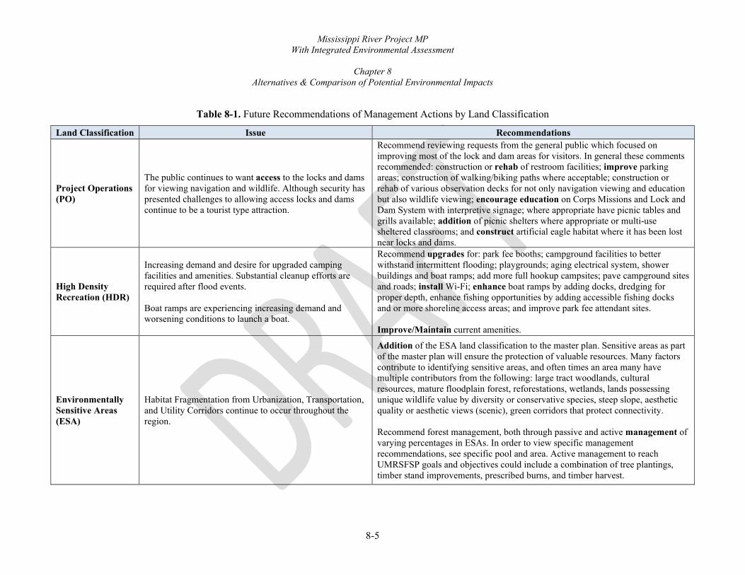
Mississippi River Project MP With Integrated Environmental Assessment
Chapter 8
Alternatives & Comparison of Potential Environmental Impacts
8-5
Table 8-1. Future Recommendations of Management Actions by Land Classification Land Classification Issue Recommendations
Project Operations (PO)
The public continues to want access to the locks and dams for viewing navigation and wildlife. Although security has presented challenges to allowing access locks and dams continue to be a tourist type attraction.
Recommend reviewing requests from the general public which focused on improving most of the lock and dam areas for visitors. In general these comments recommended: construction or rehab of restroom facilities; improve parking areas; construction of walking/biking paths where acceptable; construction or rehab of various observation decks for not only navigation viewing and education but also wildlife viewing; encourage education on Corps Missions and Lock and Dam System with interpretive signage; where appropriate have picnic tables and grills available; addition of picnic shelters where appropriate or multi-use sheltered classrooms; and construct artificial eagle habitat where it has been lost near locks and dams.
High Density Recreation (HDR)
Increasing demand and desire for upgraded camping facilities and amenities. Substantial cleanup efforts are required after flood events. Boat ramps are experiencing increasing demand and worsening conditions to launch a boat.
Recommend upgrades for: park fee booths; campground facilities to better withstand intermittent flooding; playgrounds; aging electrical system, shower buildings and boat ramps; add more full hookup campsites; pave campground sites and roads; install Wi-Fi; enhance boat ramps by adding docks, dredging for proper depth, enhance fishing opportunities by adding accessible fishing docks and or more shoreline access areas; and improve park fee attendant sites. Improve/Maintain current amenities.
Environmentally Sensitive Areas (ESA)
Habitat Fragmentation from Urbanization, Transportation, and Utility Corridors continue to occur throughout the region.
Addition of the ESA land classification to the master plan. Sensitive areas as part of the master plan will ensure the protection of valuable resources. Many factors contribute to identifying sensitive areas, and often times an area many have multiple contributors from the following: large tract woodlands, cultural resources, mature floodplain forest, reforestations, wetlands, lands possessing unique wildlife value by diversity or conservative species, steep slope, aesthetic quality or aesthetic views (scenic), green corridors that protect connectivity. Recommend forest management, both through passive and active management of varying percentages in ESAs. In order to view specific management recommendations, see specific pool and area. Active management to reach UMRSFSP goals and objectives could include a combination of tree plantings, timber stand improvements, prescribed burns, and timber harvest.

Mississippi River Project MP With Integrated Environmental Assessment
Chapter 8
Alternatives & Comparison of Potential Environmental Impacts
8-6
Table 8-1. Future Recommendations of Management Actions by Land Classification Land Classification Issue Recommendations
Multiple Resource Management Lands - Low Density Recreation (LDR)
Frequent flooding on the Mississippi River leads to greater cleanup efforts and quicker degradation of recreational amenities which creates a burden on budgets. Increasing the number of boaters and general water related activities will increase need for access to the river.
Upgrade campsites, parking lots, roads and utilities. Replace metal vault toilets with concrete. Improve areas in order to withstand frequent flooding. Construct new picnic shelters and update playgrounds where applicable. Update volunteer camp pads, to include storage areas. Expand boat ramp parking lots at heavily used areas. Place structures where needed to curb off road use.
Multiple Resource Management Lands – Wildlife Management (WM)
Fragmentation threatens large block habitats and species, some of which are listed as species of greatest concern. Invasive species continue to threaten ecological diversity. Areas with low forest diversity.
Forests and wetlands are found on the Mississippi River in large, mostly un-fragmented tracts. The Corps will continue to manage lands designated for stewardship of wildlife resources. The majority of designated wildlife management land is managed by the USFWS and DNR’s through the cooperative agreement and general plan lands. The primary strategy is to manage areas to benefit both game and non-game species. Desired levels of forest management are to passively or actively manage varying percentages in ESAs. In order to view specific management recommendations, see specific pool and area. Active management to reach UMRSFSP goals and objectives could include a combination of tree plantings, timber stand improvements, prescribed burns, and timber harvest.
Multiple Resource Management Lands – Vegetative Management (VM)
Habitat fragmentation and degradation threatens large block habitats and the species utilizing these areas.
Future Management Recommendations: Desired levels of forest management are to passively manage 50% and actively manage 50% of wildlife areas. Active management to reach UMRSFSP goals and objectives will include timber stand improvements.

Mississippi River Project MP With Integrated Environmental Assessment
Chapter 8
Alternatives & Comparison of Potential Environmental Impacts
8-7
8.5. ALTERNATIVES INCLUDING THE PROPOSED ACTION
This section describes alternatives for updating the MP. Four alternatives were considered. The MP is a land use document so rather than look at specific management actions, the team focused on varying percentages of different land classifications. A Tentatively Preferred Alternative was developed after extensive data collection and public and agency collaboration. The planning team worked on varying options that will meet the purpose and need while addressing both agency and public suggestions and developed the following four alternatives that focused on varying percentages of land classification:
Alternative 1, No Action Alternative illustrates the 1989 LUAP land classifications and proposes no change to those classifications.
Alternative 2, Balanced Focus - Tentatively Preferred Alternative, focuses on balancing current conditions of conservation and recreation on Project lands.
Alternative 3, Conservation Alternative, focuses on higher percentage of land held for conservation while lowering the percentage of lands available for recreation.
Alternative 4, Recreation Alternative, focuses on higher percentage of land held for recreation while lowering the percentage of lands available for conservation.
Table 8-2 provides a comparison of the different acreage percentages associated with each alternative. Table 8-3 shows the conversion of land classifications titles due to changes in Corps master planning regulations.

Mississippi River Project MP With Integrated Environmental Assessment
Chapter 8
Alternatives & Comparison of Potential Environmental Impacts
8-8
Table 8-2. Classification Acreage Comparison by Alternative
Alternative 11 No Action
Alternative 2* Balanced Focus
Alternative 3 Conservation
Alternative 4 Recreation
Land Classification Acres % Acres % Acres % Acres % High Density Recreation 1,707 3% 879 1% 584 1% 1,971 3% Low Density Recreation 3,129 5% 1,253 2% 881 1% 4,238 7% Wildlife Management 53,094 89% 39,056 61% 39,871 62% 53,075 83% Vegetation Management 250 0.4% 1,227 2% 657 1% 0 0% Project Operations 855 1% 1,441 2% 858 1% 1,277 2% Environmentally Sensitive 794 1% 20,542 32% 21,446 33% 3,736 6%
1 Alternative 1 acreages based on the 1989 LUAP do not reflect accretion of lands post 1989. * Indicates the Tentatively Preferred Alternative.
Table 8-3. Classification Title Comparison
1989 Land Use Allocation Plan Proposed 2021 Master Plan Project Operations Project Operations Operations-Recreation Intensive Use High Density Recreation Operations – Recreation Low Density Multiple Resource Management – Low Density Recreation Operations – Wildlife Management/Reserve Forest Land
Multiple Resource Management – Wildlife Management Multiple Resource Management – Vegetative Management
Natural Areas Environmentally Sensitive Areas

Mississippi River Project MP With Integrated Environmental Assessment
Chapter 8
Alternatives & Comparison of Potential Environmental Impacts
8-9
8.6. NO-ACTION (ALTERNATIVE 1) The No Action Alternative, which is based on the 1989 Land Use Allocation Plan (LUAP), is relatively accurate in reflecting the current land use activities and resource management within the Project. Under the 1989 LUAP, the Corps is responsible for approximately 59,800 acres of emergent Project lands as measured by that plan. This management responsibility is divided up between the Corps as well as the USFWS, IA DNR, IL DNR, and MDC through general plans and associated cooperative agreements. Approximately 92% of Project lands are managed through these agreements. The other 8% is divided up for management by the Corps and outgrants (Figure 8-2). Chapter 6, Section 6.1, explains the cooperative agreement and general plans more fully.
Figure 8-2. 1989 Management
Figure 8-3 shows the percentage of each land classification found in the 1989 LUAP. The Natural Area classification, which will be replaced per regulation by the ESA land classification, is used in the No Action Alternative for lands considered sensitive in the 1989 LUAP. In addition, the classification of Forest Reserve is now referred to as Multiple Use – WM and VM.
USFWS/States92%
Corps, 6%Outgrant, 2%
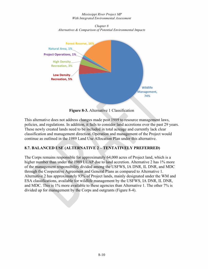
Mississippi River Project MP With Integrated Environmental Assessment
Chapter 8
Alternatives & Comparison of Potential Environmental Impacts
8-10
Figure 8-3. Alternative 1 Classification
This alternative does not address changes made post 1989 to resource management laws, policies, and regulations. In addition, it fails to consider land accretions over the past 29 years. These newly created lands need to be included in total acreage and currently lack clear classification and management direction. Operation and management of the Project would continue as outlined in the 1989 Land Use Allocation Plan under this alternative. 8.7. BALANCED USE (ALTERNATIVE 2 – TENTATIVELY PREFERRED) The Corps remains responsible for approximately 64,000 acres of Project land, which is a higher number than under the 1989 LUAP due to land accretion. Alternative 2 has 1% more of the management responsibility divided among the USFWS, IA DNR, IL DNR, and MDC through the Cooperative Agreement and General Plans as compared to Alternative 1. Alternative 2 has approximately 93% of Project lands, mainly designated under the WM and ESA classifications, available for wildlife management by the USFWS, IA DNR, IL DNR, and MDC. This is 1% more available to these agencies than Alternative 1. The other 7% is divided up for management by the Corps and outgrants (Figure 8-4).
Wildlife Management,
74%
Low Density Recreation, 5%
High Density Recreation, 3%
Project Operations, 1%
Natural Area, 1%Forest Reserve, 16%

Mississippi River Project MP With Integrated Environmental Assessment
Chapter 8
Alternatives & Comparison of Potential Environmental Impacts
8-11
Figure 8-4. Alternative 2 Management
Under Alternative 2, the land classifications would be revised to reflect current policy guidance, management practices, and responses to agency and public comments received during the scoping phase. Figure 8-5 shows the percentage of each land classification found under Alternative 2, the Tentatively Preferred Alternative. Alternative 2 proposes a decrease to 1% in the HDR classification from the No Action Alternative, 1989 LUAP. This decrease is because some areas classified as HDR in the 1970s were never constructed. In addition, many of the HDR areas have smaller footprints, and lands directly surrounding developed campgrounds are more appropriately managed for habitat and vegetation. Although the total number of acres is less under Alternative 2, there will be no changes to the current recreation areas. LDR would be decreased to 2% of Project land area compared to 5% in the No Action Alternative, 1989 LUAP. Most of the decrease in LDR acreage is due to reclassification of areas not being used, most without structures, and are more appropriately classified as WM, VM, and/or ESA. Also, in the 1989 LUAP many dredge placement areas were categorized as LDR; however, it is more appropriate to classify areas within long-term dredge placement areas as PO. Other LDR on islands in areas managed by the USFWS or state department of natural resources were reclassified as Multiple Use – WM to reflect their management for wildlife purposes. Dispersed recreation is included as an authorized use under that classification. Although the total number of acres of LDR lands would be less under Alternative 2 than under the No Action Alternative, there would still be enough LDR land to accommodate projected demands for the next 10 to 20 years.
Corps, 5%Outgrant, 2%
USFWS/States93%

Mississippi River Project MP With Integrated Environmental Assessment
Chapter 8
Alternatives & Comparison of Potential Environmental Impacts
8-12
Figure 8-5. Alternative 2 Classification
The Wildlife Management/Forest Reserve classification in Alternative 1 was mainly divided into Multiple Use – VM and WM classifications under Alternative 2. WM acreages are approximately 61% of land area, down from 53,094 to 39,044 acres, because many areas were put into the ESA classification. The WM classification also gained acres from HDR, and LDR classifications. The VM classification (Forest Reserve) was increased to approximately 2% of land area mainly due to inclusion of former LDR classified areas. The areas currently classified as Natural Areas were renamed ESAs and increased from 794 acres to 20,480 acres. The dramatic increase in ESA acres is due to a change in how Corps Regulations define sensitive areas which may include scientific (study), ecological (high diversity), state designations, cultural and/or aesthetic features requiring added protection and care in management. Natural areas in the 1989 LUAP were typically state or federally designated areas. A team of Natural Resource Specialists reviewed all areas designated as Environmentally Sensitive using criteria to locate areas in management units that qualify as ESAs. Examples of such areas include areas with high tree species diversity, designated state or Federal natural areas, areas where vegetation has been planted as mitigation for loss of natural resources, cultural sites eligible for or listed on the National Register of Historic Places, wetlands and other high-value aquatic sites, areas where natural vegetation or topography serves as important visual or noise buffers, seasonally closed wildlife refuge areas, known listed species occurrence/habitat, significant wildlife nesting or use, and areas having exceptional aesthetic qualities. Table 8-4 lists areas proposed to be categorized as ESA under the Tentatively Preferred Alternative. A total of 20,512 acres would be designated as ESA.
Wildlife Management
61%
Low Density Recreation, 2%
High Density Recreation, 1%
Project Operations, 2%
Vegetative Management2%
Environmentally Sensitive32%

Mississippi River Project MP With Integrated Environmental Assessment
Chapter 8
Alternatives & Comparison of Potential Environmental Impacts
8-13
PO classification footprint increased due to inclusion of rights-of-way for earthen embankments and other structures under the Corps’ Flood Risk Management Program (FRMP). The levee and drainage districts maintain the areas, and control vehicles access along the right of way. The Corps provides requirements on levee maintenance and works closely with the districts. Alternative 1 had previously designated many of these areas as Wildlife Management/Reserve Forest and included in GP Lands for management by wildlife agencies. Given the nature of the area and maintenance needs, they are more appropriately labeled PO classification and proposed for removal from GP Lands.

Mississippi River Project MP With Integrated Environmental Assessment
Chapter 8
Alternatives & Comparison of Potential Environmental Impacts
8-14
Table 8-4. Area Proposed for Environmentally Sensitive Area Classification Under Alternative 2, Tentatively Preferred Alternative
Pool ~River Mile Place Name Current Land Classification 1
Proposed Land Classification
Managing Agency(ies)
11 607 (WI) Cassville ESA WM/RIU ESA Corps 11 600 (WI) Bertom Lake and McCartney Lake ESA WM ESA USFWS 11 593 (WI) Grant River ESA WM ESA USFWS 11 592 (WI) Patzner ESA RIU ESA USFWS 12 577 (IL) Switzer Lake ESA WM/PO ESA USFWS 12 575 (IL) Frentress Lake ESA WM ESA USFWS 12 572 (IL) Menominee/Sinsinawa ESA WM ESA USFWS 12 577 (IA) Catfish Creek ESA NA ESA Corps 13 555 (IA) Bellevue ESA RLD/SU ESA Corps 13 550 (IA) Pleasant Creek ESA WM ESA USFWS 13 547 (IA) Green Island ESA WM ESA IA DNR 13 544 (IL) Arnold ESA WM/RLD/SU ESA USFWS 13 534 (IL) Spring Lake ESA WM ESA USFWS 13 530 (IA) Elk River Bottoms ESA WM ESA USFWS 13 528 (IL) Turtle Road ESA WM/NA ESA Corps/USFWS 13 526 (IL) Thomson Causeway ESA WM/RIU ESA Corps/USFWS 13 525 (IL) Thomson-Fulton Sand Prairie ESA WM/NA ESA Corps/USFWS 14 515 (IA) Beaver Island ESA WM/RLD/PU ESA USFWS 14 508 (IA) Wapsipinicon River Bottoms ESA WM ESA USFWS 14 496 (IL) Rapid City ESA RLD ESA Corps 14 494 (IL) Fisherman’s Corner ESA RIU ESA Corps 16 477 (IL) Milan Bottoms ESA WM ESA IL DNR 17 444 (IA) Port Louisa NWR – Big Timber Division ESA WM ESA USFWS 17 440 (IA) Port Louisa NWR – Louisa Division ESA WM ESA USFWS 17 437 (IA) Lake Odessa Wildlife Management Area ESA WM ESA IA DNR 18 433 (IL) Boston Bay ESA WM/RLD/PU ESA IL DNR 18 430 (IL) Keithsburg ESA and ILDNR Wildlife Area WM ESA USFWS/IL
18 424 (IA) Huron Island ESA WM ESA IA DNR

Mississippi River Project MP With Integrated Environmental Assessment
Chapter 8
Alternatives & Comparison of Potential Environmental Impacts
8-15
Table 8-4. Area Proposed for Environmentally Sensitive Area Classification Under Alternative 2, Tentatively Preferred Alternative
Pool ~River Mile Place Name Current Land Classification 1
Proposed Land Classification
Managing Agency(ies)
18 422 (IL) Big River ESA RIU ESA Corps/IL DNR 337 (IL) Long Island ESA WM/RLD/PU ESA USFWS
22 321 (MO) North River ESA WM ESA MDC 22 311 (MO) Bay Island ESA WM ESA MDC 22 301 (IL) Park-N-Fish ESA RLD/SU ESA Corps
1 WM - Wildlife Management/Reserve Forest Land RIU - Recreation/Intensive Use PO - Project Operations NA - Natural Area RLD/PU - Recreation/Low Density Use/Public Use RLD/SU - Recreation/Low Density/Special Use

Mississippi River Project MP With Integrated Environmental Assessment
Chapter 8
Alternatives & Comparison of Potential Environmental Impacts
8-16
Figure 8-6 shows the breakdown of the 5% of lands managed directly by the Corps. The amount of recreation that can occur on Project lands on the Mississippi River is directly affected by how frequently areas will flood. A look at the percentage of lands that are frequently flooded shows this correlation (Figure 8-7). The Corps has many recreation areas and those recreation areas generally are found on the limited uplands or areas prone to intermittent or frequent flooding.
Figure 8-6. Classification Breakdown of Areas Directly Managed by the Corps
Figure 8-7. Project Lands Percent of Acreage Under Water or Subject to Flooding
Open Water, 35%
Frequently Flooded, 62%
Infrequently Flooded, 3%
Breakdown of the 5% Corps directly manages.
Low Density Recreation, 11%
High Density Recreation,
12%
Project Operations
27%
Vegetative Management,
41%
Environmentally Sensitive, 9%Corps, 5%
Outgrant, 2%
USFWS/States, 93%

Mississippi River Project MP With Integrated Environmental Assessment
Chapter 8
Alternatives & Comparison of Potential Environmental Impacts
8-17
8.8. CONSERVATION FOCUS (ALTERNATIVE 3) Under Alternative 3, the land classifications would further increase natural resource protection by increasing the total acreage in WM, VM, and ESA classifications while HDR and LDR classifications would decrease. This alternative would create more protected shoreline within the Project than all other alternatives. HDR and LDR Areas acreages would be reduced to only those areas that are maintained and contain infrastructure, reducing their size by roughly one-third and one-quarter, respectively, from Alternative 2. Existing permitted shoreline uses would be grandfathered in, but there would be no LDR classification used for current recreation areas with low usage. The acreage removed from these classifications would be included in VM or WM classifications. Areas that are currently seasonally closed wildlife refuge areas would revert to ESAs if they are not already. This adds over 900 acres of ESA lands. Under Alternative 3, 96% of Project lands would be made available to the USFWS and state wildlife agencies for management (Figure 8-8).
Figure 8-8. Alternative 3 Management
Alternative 3 compared to Alternative 2 proposes HDR decreases to 584 acres, LDR decreases to 881 acres, VM decreases to 657 acres, WM increases to 39,871 acres, and ESA increases to 21,446 acres. Most of the decrease in HDR and LDR acreage would be due to reclassification of areas to more conservative classifications (Figure 8-9).
USFWS/States, 96%
Corps, 2% Outgrant, 2%

Mississippi River Project MP With Integrated Environmental Assessment
Chapter 8
Alternatives & Comparison of Potential Environmental Impacts
8-18
Figure 8-9. Alternative 3 Classification
8.9. RECREATION FOCUS (ALTERNATIVE 4)
This alternative would increase Project lands available for recreational development by adding to existing HDR and LDR classified areas. Additional LDR classified acreage would come mainly from existing WM and VM with minimal acreage from PO classification. New and expanded LDR classification would include designating existing boat ramps and access areas as LDR. It would also add designation for many areas with available public road access. Increases in HDR would mainly come from LDR with less amounts from WM and VM through expansion of camping areas into the surrounding classifications and some newly classified HDR areas. This would allow for more camping loops and pads pending available resources. More Project lands would be made available for outgrants to states, counties, cities, and commercial entities. The allocation of lands made available for private use is established under the Shoreline Management Plan (SMP).
Wildlife Management,
62%
Low Density Recreation, 2%
High Density Recreation, 1%
Project Operations, 1%
Vegetative Management, 1%
Environmentally Sensitive, 33%

Mississippi River Project MP With Integrated Environmental Assessment
Chapter 8
Alternatives & Comparison of Potential Environmental Impacts
8-19
Figure 8-10. Alternative 4 Management
Land classifications would reflect a higher amount of recreation than all the other alternatives. However, lands managed by the USFWS and state wildlife agencies would stay the same as Alternative 1 as shown in Figure 8-10. Figure 8-11 shows the percentages of land classifications proposed in Alternative 4. This alternative would expand upon the lands designated for recreation on USFWS- and state wildlife agency-managed lands present in Alternative 1 placing additional emphasis on recreation development as it fits with those agencies’ missions, plans, and resources. ESAs would be focused solely on areas with a preponderance of significant resources.
Figure 8-11: Alternative 4 Classification
USFWS/States92%
Corps, 6%Outgrant, 2%
Wildlife Management
82%
Low Density Recreation, 7%
High Density Recreation, 3%
Project Operations, 2% Environmentally Sensitive, 6%

Mississippi River Project MP With Integrated Environmental Assessment
Chapter 8
Alternatives & Comparison of Potential Environmental Impacts
8-20
Alternative 4 increases HDR to 1,971 acres, LDR acres to 4,238 acres, WM to 53,075, decrease in PO acres to 1,277, and a significant decrease in ESA to 3,736 acres. 8.10. ALTERNATIVES NOT CARRIED FORWARD FOR FURTHER ANALYSIS Many alternatives could have been brought forward with different iterations of land classifications and acreages. However, public comments regarding the MP Revision did not include changes to land classifications. The public did make many comments on the specific types of future management recommendations for various existing recreation areas such as Wi-Fi, updated campground amenities, etc. Many of the public’s suggested future management activities were already part of, or incorporated into, the design of the Tentatively Preferred Alternative. All the alternatives allow for requests for activities and/or changes to land classifications; however, requests would need to follow the Master Plan Supplement guidance and proceed through normal action approval processes. Agencies made specific comments on land classification changes and concurred that General Plan Lands mapping exhibits and acreage totals be updated concurrently with the MP to reflect current land use and management responsibility.
Other comments were considered outside the Project’s purpose and need and/or would not comply with the MP scope, direction, or applicable environmental regulations. The interdisciplinary team did not identify any issues where the extent of geographic distribution of effects, duration of effects, or intensity of interest warranted analyzing Alternatives 3 and 4 in further detail. 8.11. EVALUATION OF ALTERNATIVES AND SELECTION OF TENTATIVELY PREFERRED ALTERNATIVE Under any of the alternatives, the Corps would continue to implement its other management plans and comply with existing regulations that relate to management of Project lands. These include:
• Operational Management Plan for the Project • Systemic Forest Stewardship Plan • 2001 Amendment of the Cooperative Agreement with the USFWS regarding wildlife
management • General Plans Lands with WI, IL, IA, and MO regarding wildlife management • Mississippi Mainstem System Master Water Control Manual (Master Manual) which
governs reservoir operations

Mississippi River Project MP With Integrated Environmental Assessment
Chapter 8
Alternatives & Comparison of Potential Environmental Impacts
8-21
• All Master Plan actions will be coordinated individually with the appropriate SHPO (WI, IL, IA, and/or MO) and tribal representatives for compliance with the National Historic Preservation Act
• Mississippi River Historic Properties Plan • Mississippi River Shoreline Management Plan
The No Action Alternative would not meet the purpose and need of the MP which is to provide up-to-date guidance in Corps decision-making and a framework for development and implementation of the Operational Management Plan (OMP) and Annual Management Plans. The MP must be kept current to provide effective guidance. Although any major future developments or resource management policies would require approval on a case-by-case basis, it would be without the benefit of evaluation in the context of an overall plan. For this Integrated EA, the “No Action” Alternative does not achieve the potential of effective resource management. Alternative 2, the Tentatively Preferred Alternative, represents the best combination of land classifications, types and levels of resource development, management, and conservation activities for the various management units on the Mississippi River that would 1) meet Project purposes and agency/public needs and desires, 2) be consistent with minimizing adverse environmental impacts and ensuring environmental sustainability, and 3) be compatible with all applicable laws and regulations as well as regional plans. Management of the Project would be accomplished in accordance with the resource objectives outlined in Chapter 3, Resource Objectives. The Preferred Alternative establishes appropriate resource objectives for the Project, prescribes land classifications, identifies development and management needs, provides management guidelines, and establishes the locations and suitable levels of recreation development. Although Alternative 3, Conservation, would meet the purpose and need in updating the MP, it was not selected as the Tentatively Preferred Alternative because the increase in acres classified as VM is at the expense of lands classified as LDR and HDR. The public voiced opinions that developed recreational opportunities should remain the same as in the past. Alternative 4, Recreation would also meet the purpose and need, but it was not selected as the Tentatively Preferred Alternative. Expanding recreation areas at this time is unnecessary as 1) population levels have remained stable in the region, 2) most of the recreation areas fall within the floodplain and are subject to flooding, 3) budgets do not allow for an expanded recreational programs, and 4) there were nearly no requests for new recreation areas by state, county, or municipalities during scoping. The Tentatively Preferred Alternative provides a framework for the OMP and provides a basis for reviewing outgrant and recreation development proposals. If approved, the revised MP is
-

Mississippi River Project MP With Integrated Environmental Assessment
Chapter 8
Alternatives & Comparison of Potential Environmental Impacts
8-22
expected to be in effect for approximately 20 years. The MP will be reviewed by the Project and District every five years. The Project will work with District staff if a supplement requiring District Engineer approval is identified during a review. OMP I & II should support the concept and vision of the master plan and will be utilized for more specific stewardship and recreation plans as shown in Figure 8-12. The OMP I & II will be reviewed for updates after the completion of the MP.
Figure 8-12. Connection Between the Master Plan, Operational Management Plans, and Specific
Natural Resource Management Plans
8.12. COMPARISON OF EFFECTS OF ALTERNATIVES BY RESOURCE This section describes the environmental consequences associated with the alternatives presented above. NEPA requires consideration of context, intensity, duration of adverse and
MASTER PLAN Vision, Concepts and Recommendations for
Future Management Activities
OPERATIONAL MANAGEMENT PLANS
(OMPI & 11) Detailed Management and Administrative Functions
OMPI Specific Action Tasks for Natural Resource Management Activities
PLANS Forestry, Invasive
Species, Vegetation, Wildlife .
OMPII Specific Action Tasks
for Recreation Management Activities
PLANS Recreation Facilities,
Safety Plan, Interpretation

Mississippi River Project MP With Integrated Environmental Assessment
Chapter 8
Alternatives & Comparison of Potential Environmental Impacts
8-23
beneficial impacts (direct, indirect, and cumulative), and measures to mitigate for impacts. These elements are considered in the following impact analysis. Use of the proposed MP would help define the approval process for future actions affecting Project lands, depending on whether the actions are 1) specifically included in the MP, 2) not included in the MP, but consistent with the Plan, or 3) not included and not consistent with the recommendations, objectives and policies stated in Corps regulations (Corps, 2009). It is important to note that the Integrated EA assesses the impacts of adopting the Land Classifications included in the proposed MP but not the specific recommended future management actions and opportunities mentioned in Table 8-1, Future Recommendations of Management Actions by Land Classification. These recommendations will be part of the OMP and identified as tasks to be reviewed, coordinated, and completed later. Because of the wide variety of possible future management recommendations or tasks that could be proposed, an additional evaluation to determine consistency with the stated site objectives and further NEPA consideration would be required as these tasks are undertaken. This section summarizes and compares the effects of the alternatives. For information on the affected environment resources, see Chapter 2, Affected Environment.
8.12.1. Environmental Impacts. The greatest drivers of impacts on environmental resources on the Mississippi River are flooding, invasive species, forest age and lack of diversity, navigation, residential and commercial development. Development of the floodplain, past logging, and levees have left a narrow strip of forest along the river. Species composition of the remaining forest has also become less diverse, due in part to altered hydrology, a loss of the seasonal “flood pulse” and the effects of periodic severe flooding, particularly the flood of 1993. Bank erosion also has affected floodplain forests to some degree. Diseases, insects, and invasive plant species also continue to negatively impact the floodplain forest (Corps, 2012). As discussed in Chapter 2, Section 2.1, Demographics, there is expected to be a slight increase in population in the region between 2010 and 2050. Over the past decade, the Dubuque, Quad Cities, and Quincy Metro areas have seen growth while rural areas have seen slight declines. Population is not expected to have a significant impact on Project resources at this time. Table 8-5 shows the environmental impacts of each alternative. When future recommendations are implemented, additional site-specific analysis and review for NEPA compliance will be undertaken.

Mississippi River Project MP With Integrated Environmental Assessment
Chapter 8
Alternatives & Comparison of Potential Environmental Impacts
8-24
Table 8-5. Environmental Impacts of the Four Alternatives
Public Interest Category/Measure
Alt 1 No Action
Alt 2 Balanced Focus
Alt 3 Conservation
Alt 4 Recreation
Geology, Topography, Soils o o o o Floodplains o o o o Water Resources o o o o Air Quality o o o o Climate o o o o Noise o o o o Hazardous Materials o o o o Recreation and Aesthetics o + - + Vegetation o + + o Fish and Wildlife o + + o Threatened & Endangered Species o + + o Wetlands o o o o Invasive Species o o o o Water Quality, Wetlands, Rivers,
o o o o
Land Use o + - - Community Growth o o o o Community Cohesion o o o o Displacement of People o o o o Environmental Justice o o o o Property Value/Tax Base o o o o Public Facilities and Services o o o o Employment o o o o Business Growth o o o o Farm Displacement o o o o Transportation o o o o Utilities o o o o Safety o o o o Cultural and Historic Resources o + + o + Expected moderate long-term environmental or social benefit as a result of alternative implementation. o No or minor expected long-term environmental or social benefit or impact as a result of alternative implementation. - Expected moderate long-term environmental or social impact as a result of alternative
8.12.1.1. Effects on Floodplains and Flooding. To meet the missions of the Corps and the other management partners on the Mississippi River, many developed sites and facilities are located within the floodplain. Most of these structures have been designed to withstand and not interfere with the conveyance of floodwaters. All actions occurring within floodplains must be consistent with EO 11988, Floodplain Management, and related Corps policy. There will be no change of effects on floodplains and flooding because of implementation of any of the alternatives.

Mississippi River Project MP With Integrated Environmental Assessment
Chapter 8
Alternatives & Comparison of Potential Environmental Impacts
8-25
8.12.1.2. Effects on Water Resources. There are no significant environmental impacts to water resources from implementation of any of the alternatives. Operations at Corps facilities and projects are monitored through annual assessments performed as part of the Environmental Review Guide for Operations (ERGO) system. The assessments provide an evaluation of compliance with all applicable Federal, state, and local environmental laws and regulations by identifying environmental problems and rating these problems as minor, major, or significant, with associated levels of corrective action. Issues related to solid waste handling, erosion control, toxic and hazardous waste handling and management, and other considerations affecting water resources and quality are evaluated. Regardless of which alternative is chosen the ERGO system would continue to insure that impacts of PO on water resources and quality would be identified early and corrected. There will be no change of effects on water resources because of implementation of any of the alternatives.
8.12.1.3. Effects on Air Quality. Air quality within the Project area can be influenced by exhaust from motor vehicles and boats, the use of grills and fire pits, and other regional activities such as large-scale farming operations and construction projects. Lands currently classified for Recreation or PO have the greatest potential to produce actions that may negatively influence air quality. More specifically, the developed lands within these classifications include the heaviest concentrations of motor vehicle exhaust and building emissions within the Project area. The undeveloped and Multiple Resource Management areas have limited impacts to air quality. Impacts in these areas are confined to short-term effects from forestry or construction actions. There will be no effect on Air Quality because of implementing any of the alternatives.
8.12.1.4. Effects on Climate. Implementation of the Tentatively Preferred Alternative will not have a negative effect on climate. Ongoing research by the Corps’ Institute for Water Resources on carbon sequestration potential of Project lands and jurisdictional water demonstrates a potential to capture and store greenhouse gases in vegetation and in reservoir sinks which provides a considerable beneficial impact. There will be no effect on climate because of implementing any of the alternatives.
8.12.1.5. Effects on Noise. The implementation of any of the alternatives will have no negative effect on noise levels on the Mississippi River; conversely, the continued protection of Federal lands will provide a sanctuary for those seeking to reconnect with nature. Noise levels are further decreased in the winter when boating and navigation traffic are minimal as river ice restricts motorized vessels. Areas within the Project have limited outside noise sources with most noise coming from traffic from the surrounding communities and highways. Lands currently classified for intensive use or operations have the greatest potential to create noise within the Project area. With such minimal changes to these classifications there will be no effect on noise levels because of implementing any of the alternatives.
8.12.1.6. Effects on Recreation and Aesthetic Resources. Although maintenance of current recreational facilities would continue under the No Action Alternative, the1989 MP

Mississippi River Project MP With Integrated Environmental Assessment
Chapter 8
Alternatives & Comparison of Potential Environmental Impacts
8-26
would not accurately reflect the status of facilities or the higher use patterns. Additionally, under Alternative 3, the number and acreage of recreation facilities would be reduced to accommodate a Conservation-Focused Master Plan. The public’s recreational needs would be better accommodated through the implementation of the Tentatively Preferred Alternative. Future management recommendations are based on review of the existing facilities, resource suitability, trends, and forecasts of future demand. There would be a benefit to recreation, not only from modernizing and upgrading existing facilities but also from increasing the management of natural resources through some of the recommendations in Chapter 5, Resource Plan. Such recommendations could improve the health of local habitats and encourage wildlife diversity. Enhancing the camping experience with modern, upgraded facilities would also complement the existing campsites presently available.
Increased recreational use in an area may reduce the aesthetic qualities at varying scales. It is critical to make determinations on the types of amenities that will result in the lowest impact to the resource. Overall, the implementation of any of the alternatives would not impact the viewshed; the area would remain like the existing conditions with minimal or no negative impacts to aesthetics on public lands. Protection of Federal lands under the sensitive area categories will ultimately benefit recreational and aesthetic resources located within the Project.
8.12.1.7. Effects on Vegetation. Management of habitat for wildlife follows the existing OMP, which uses best management practices, coordination among agencies, and guidance to ensure environmental stewardship. Under the No Action Alternative, the 1989 LUAP no longer accurately reflects the status of vegetative resources within the Project. With implementation of the Tentatively Preferred Alternative, vegetative resources would be better accommodated through analyzing natural resources based on current conditions, resource suitability, and trends occurring on the landscape. Implementing the goals and objectives found in Chapter 3, Resource Objectives, would benefit natural resources by improving the health of local habitats, which in turn encourages wildlife diversity. Effects on vegetation would be beneficial under the Tentatively Preferred Alternative.
8.12.1.8. Effects on Soils. The Farmland Protection Policy Act (FPPA) requires an evaluation of any prime or unique soils and is intended to minimize the impact Federal programs have on the unnecessary and irreversible conversion of farmland to nonagricultural uses. While most soils within the project area are not considered farmland due to their sand content and proclivity to flooding, prime and unique soils do exist within the Project. The land classification changes proposed in the Tentatively Preferred Alternative would not impact existing prime and unique soils found within the Project area. Site-specific actions taken that agree with the Tentatively Preferred Alternative would require an analysis of any prime or unique soils present as well as an evaluation of potential impacts to these resources.
8.12.1.9. Effects on Fish and Wildlife. Although fish and wildlife management would continue under the No Action Alternative, the 1989 MP no longer accurately reflects the status of fish and wildlife resources within the Project. With implementation of the

Mississippi River Project MP With Integrated Environmental Assessment
Chapter 8
Alternatives & Comparison of Potential Environmental Impacts
8-27
Tentatively Preferred Alternative, fish and wildlife resources would be better accommodated by analyzing current conditions, resource suitability, and fish and wildlife trends. Protecting the relatively undeveloped public lands within the Project, which have become increasingly valuable to native species as habitat, provides benefits to fish and wildlife populations. Protection and management of sensitive areas will also provide benefits to fish and wildlife. Following the goals and objectives found in Chapter 3, Resource Objectives, would benefit fish and wildlife by improving the health of local habitats and, in turn, encourages wildlife diversity. Effects on fish and wildlife populations would likely benefit under the Tentatively Preferred Alternative.
8.12.1.10. Effects on Threatened and Endangered Species. The Corps expects the Tentatively Preferred Alternative will have “no effect” on any Federally-listed or proposed threatened or endangered species listed in Chapter 2, Project Setting, Factors Influencing Management & Development. The Corps based this statement on the fact that the Master Plan is a land use planning document and does not propose specific actions that may affect Federally listed species. Land classification changes included in the Tentatively Preferred Alternative include an increase in the number of ESAs within the Project. These designations will have beneficial impacts on listed species. Furthermore, the Tentatively Pref erred Alternative proposes not changes to the classification of aquatic areas meaning the pallid sturgeon and mussel species listed in Chapter 2, Table 2-9 would not be affected by the implementation of the Tentatively Preferred Alternative. The No Action Alternative does not include a current list of threatened and endangered species. The Project will continue to provide a corridor of habitat that is becoming increasingly scarce in the Midwest. The addition of the ESAs classification would further protect natural resources from development encroachment and habitat fragmentation. Where identified, state listed species and species of greatest conservation need are included in sensitive area determinations. The No Action Alternative does not include the revised land classifications and management actions affecting Federal lands. Actions would require analysis on a case-by-case basis without the benefit of evaluation in the context of an overall plan. Additional protection is provided by specific legislation, such as the Bald and Golden Eagle Protection Act and the Migratory Bird Treaty Act. The Corps will take actions, in compliance with Federal and State laws and regulations, to ensure that any future management recommendations will not adversely affect any threatened and endangered species or any critical habitat that may have been established in or near areas potentially affected by proposed undertakings. Actions would be reviewed and determination on the type of NEPA documentation would be determined at that time. There will be no effects on threatened and endangered resources because of implementation of any of the alternatives.
8.12.1.11. Effects on Wetlands. The effects to wetlands regarding the No Action Alternative and the Tentatively Preferred Alternative are essentially the same with the exception of the addition of ESAs in the Tentatively Preferred Alternative, which would provide another level of protection and consequently benefit to natural resources. Wetlands are regulated under Section(s) 401 and 404 of the Clean Water Act. Section 401 Water

Mississippi River Project MP With Integrated Environmental Assessment
Chapter 8
Alternatives & Comparison of Potential Environmental Impacts
8-28
Quality Certification ensures compliance with water quality standards. Section 404 regulates activities within Waters of the U.S., which includes the Mississippi River and its surrounding tributaries. Further direction is provided by EO 11990, Protection of Wetlands, and related Corps regulations. The Corps and the respective Departments of Natural Resources are responsible for implementing these regulations through a permitting process. There will be no effect on wetlands because of implementing any of the alternatives.
8.12.1.12. Effects on Invasive Species. Implementation of any of the alternatives will not have a negative effect on invasive species management. Regardless of which alternative moves forward, the Corps will continue to implement best management practices with regards to invasive species management within the Project. Following Corps policy and using adaptive and best management practices in prevention, education, early detection, rapid response, and containment of invasive species will aid in cost effective and environmentally sound invasive species management. There will be no effect on the management of invasive species as a result of implementing any of the alternatives.
8.12.1.13. Effects on Socioeconomic Characteristics
• Community Cohesion and Regional Growth. The Project provides many recreation opportunities for the surrounding community and the region at large. The implementation of the Tentatively Preferred Alternative would not be expected to significantly impact these areas of growth. The Project provides nearby and surrounding communities with vast opportunities for boating, waterfowl hunting, fishing, swimming, wildlife observation, photography, plus activities enhanced by proximity to water such as hiking, picnicking, bird watching, camping, and water sports.
• Property Values and Tax Revenues. The implementation of the Tentatively Preferred Alternative should not bring forth any change in property values or tax revenues. Any increase in recreational visitors to the area would likely mean more dollars spent in local retail establishments, resulting in an increase in tax revenues for the surrounding communities.
• Public Facilities and Services. Overall, the implementation of the Tentatively Preferred Alternative seeks to positively enhance public facilities and services by enhancing outdoor recreational opportunities.
8.12.1.14. Effects on Environmental Justice. Effects on Environmental Justice. Environmental justice is defined as the fair treatment and meaningful involvement of all people, regardless of race, color, national origin, or income, with respect to the development, implementation, and enforcement of environmental laws, regulations, and policies. The EPA further defines fair treatment to mean that no group of people should bear a disproportionate

Mississippi River Project MP With Integrated Environmental Assessment
Chapter 8
Alternatives & Comparison of Potential Environmental Impacts
8-29
share of the negative environmental consequences of industrial, governmental, or commercial operations or policies. Executive Order 12898: Federal Actions to Address Environmental Justice in Minority Populations and Low-Income Populations (February 16, 1994) provides that each federal agency shall make achieving environmental justice part of its mission by identifying and addressing disproportionately high and adverse human health or environmental effects of its programs, policies, and activities on minority populations and low-income populations. Environmental justice concerns may arise from impacts on the natural and physical environment, such as human health or ecological impacts on minority populations, low-income populations, and Indian tribes or from related social or economic impacts.
NEPA does not specify significance thresholds that may be used to evaluate the effects of a proposed action related to environmental justice. However, Council on Environmental Quality (CEQ) guidance requires an evaluation of a proposed action’s effect on the human environment, and the Corps must comply with Executive Order 12898. The Corps has determined that the proposed action or its alternatives would result in significant effects related to environmental justice if they would disproportionately adversely affect an environmental justice (EJ) community through its effects on:
• Environmental conditions such as quality of air, water, and other environmental media; degradation of aesthetics, loss of open space, and nuisance concerns such as odor, noise, and dust;
• Human health such as exposure of EJ populations to pathogens;
• Public welfare in terms of social conditions such as reduced access to certain amenities like hospitals, safe drinking water, public transportation, etc.; and,
• Public welfare in terms of economic conditions such as changes in employment, income, and the cost of housing, etc.
The Corps conducted an evaluation of EJ impacts using a two-step process. As a first step, the study area was evaluated to determine whether it contains a concentration of minority and/or low-income populations. EPA’s Environmental Justice Screening and Mapping Tool (EJSCREEN; https://www.epa.gov/ejscreen) was used for this step. Data for the environmental indicators show that all are in mid to low percentiles (<60%) compared to the rest of the state, suggesting there are very few areas of concern with air and water quality or other environmental factors. Queries of the EJ Mapper shows the project area and surroundings contain a mix of income levels and minority populations. Following that evaluation in a second step, the Corps determined whether the proposed action and its alternatives would result in the types of effects listed above. The study area was determined to be in a mixed area that does not constitute an EJ population for either minority or low-income populations. Moreover, the proposed action includes changes to land use planning and does not result in any physical changes to the project area. Therefore, the Corps has determined the Tentatively Preferred Alternative would not have disproportionate effects on low-income or minority populations.

Mississippi River Project MP With Integrated Environmental Assessment
Chapter 8
Alternatives & Comparison of Potential Environmental Impacts
8-30
8.12.1.15. Effects on Utilities. The addition of ESAs may require a more stringent process for allowing non-recreational outgrants (Chapter 6, Special Topics). However, most ESAs are part of the National Wildlife Refuge system, which is already considered sensitive for utility project planning purposes. Utility projects should use current utility corridors whenever possible to minimize adverse environmental impacts by avoiding sensitive resources such as wetlands and known historic and archaeological sites, as well as popular and heavily utilized recreational areas. Identifying sensitive areas may be beneficial to utilities in the initial planning stages. Although there may be negative effects on utilities, the significance of those effects is low. Under any alternative, the non-recreational outgrant policy would be in effect, which would require utilities to avoid and minimize impacts to Federal lands. The increase in ESAs would provide an additional consideration for routing of utilities that otherwise wouldn’t be in effect.
8.12.1.16. Effects on Safety. The Tentatively Preferred Alternative will have no effect on the current Mississippi River Safety Plan which identifies safety concerns, responsibilities, and management techniques for different environments at the Project. The Corps will continue to actively promote general visitor safety including a strong focus on water safety. There will be no effects on safety because of implementation of any of the alternatives.
8.12.1.17. Effects on Cultural Resources. Section 106 of the National Historic Preservation Act of 1966, as amended, and its implementing regulations 36 CFR Part 800 require Federal agencies to take into account the effect of an undertaking on historic properties if that Project is under the direct or indirect jurisdiction of the agency or has been licensed or assisted by that agency. The Corps determined that the implementation of the Tentatively Preferred Alternative, would have “No Effect” on historic properties. Likewise, the reclassifications included in the Tentatively Preferred Alternative, including sensitive area designations, would further protect historic properties and sites. The Corps will continue to manage public lands within the Project through coordinating with interested parties should any future management practices result in separate undertakings in accordance with the Section 106 process. While the Corps asserts that no historic properties would be affected by the Tentatively Preferred Alternative, if any undocumented cultural resources are identified or encountered, the Corps would discontinue activities and resume coordination with the consulting parties to identify the significance of the historic property and determine any potential effects.
8.12.1.18. Effects on Other Land Management Plans. Section 1506.2(d) of Title 40 of the Code of Federal Regulations (CFR) states, to better integrate environmental impact statements into state or local planning processes, statements shall discuss any inconsistency of a proposed action with any approved state or local plan and laws (whether or not federally sanctioned). The Corps reviewed land management plans in the drafting of the MP including most notably the USFWS Comprehensive Conservation Plans and Habitat Management Plans for refuges on Project and state Wildlife Action Plans. The Tentatively Preferred Alternative was found to be neutral or positive for those plans.
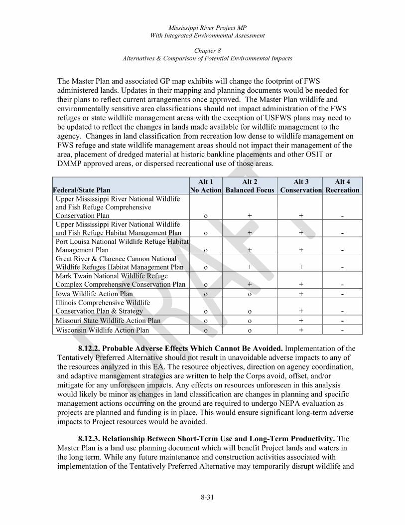
Mississippi River Project MP With Integrated Environmental Assessment
Chapter 8
Alternatives & Comparison of Potential Environmental Impacts
8-31
The Master Plan and associated GP map exhibits will change the footprint of FWS administered lands. Updates in their mapping and planning documents would be needed for their plans to reflect current arrangements once approved. The Master Plan wildlife and environmentally sensitive area classifications should not impact administration of the FWS refuges or state wildlife management areas with the exception of USFWS plans may need to be updated to reflect the changes in lands made available for wildlife management to the agency. Changes in land classification from recreation low dense to wildlife management on FWS refuge and state wildlife management areas should not impact their management of the area, placement of dredged material at historic bankline placements and other OSIT or DMMP approved areas, or dispersed recreational use of those areas.
Federal/State Plan Alt 1
No Action Alt 2
Balanced Focus Alt 3
Conservation Alt 4
Recreation Upper Mississippi River National Wildlife and Fish Refuge Comprehensive Conservation Plan o + + - Upper Mississippi River National Wildlife and Fish Refuge Habitat Management Plan o + + - Port Louisa National Wildlife Refuge Habitat Management Plan o + + - Great River & Clarence Cannon National Wildlife Refuges Habitat Management Plan o + + - Mark Twain National Wildlife Refuge Complex Comprehensive Conservation Plan o + + - Iowa Wildlife Action Plan o o + - Illinois Comprehensive Wildlife Conservation Plan & Strategy o o + - Missouri State Wildlife Action Plan o o + - Wisconsin Wildlife Action Plan o o + -
8.12.2. Probable Adverse Effects Which Cannot Be Avoided. Implementation of the Tentatively Preferred Alternative should not result in unavoidable adverse impacts to any of the resources analyzed in this EA. The resource objectives, direction on agency coordination, and adaptive management strategies are written to help the Corps avoid, offset, and/or mitigate for any unforeseen impacts. Any effects on resources unforeseen in this analysis would likely be minor as changes in land classification are changes in planning and specific management actions occurring on the ground are required to undergo NEPA evaluation as projects are planned and funding is in place. This would ensure significant long-term adverse impacts to Project resources would be avoided.
8.12.3. Relationship Between Short-Term Use and Long-Term Productivity. The Master Plan is a land use planning document which will benefit Project lands and waters in the long term. While any future maintenance and construction activities associated with implementation of the Tentatively Preferred Alternative may temporarily disrupt wildlife and

Mississippi River Project MP With Integrated Environmental Assessment
Chapter 8
Alternatives & Comparison of Potential Environmental Impacts
8-32
human use in Project areas, negative long-term impacts are expected to be minimal or non-existent.
8.12.4. Irreversible or Irretrievable Commitment of Resources if the Project Is Implemented. The commitment of man-hours required to write, coordinate, and review the proposed MP Revision are irretrievable. Other than the aforementioned, none of the proposed actions are considered irreversible.
8.12.5. Relationship of the Proposed Project to Land-Use Plans. Implementation of the Tentatively Preferred Alternative is a land-use planning change. The land-use changes, which the Corps refers to as Land Classifications, are being updated to reflect current conditions and meet current regulations. The Tentatively Preferred Alternative is consistent with other state and regional goals and programs. If implemented, the Corps does not expect the proposed action to alter or conflict with other authorized civil works projects.
8.12.6. Indirect and Cumulative Impacts of the Tentatively Preferred Alternative. The Council on Environmental Quality regulations that implement NEPA require assessment of cumulative impacts in the decision-making process for Federal projects. Cumulative impacts are defined as impacts which result when the impact of the Tentatively Preferred Alternative is added to the impacts of other present and reasonably foreseeable future actions, regardless of what Federal or non-Federal agency or person undertakes such other actions (40 CFR 1508.7). The cumulative impacts associated with the Tentatively Preferred Alternative and the No Action Alternative are as follows:
Past, present, and reasonably foreseeable future actions have and continue to contribute to the cumulative impacts of activities in and around Project lands and waters. Past actions include the construction and operation of the lock and dam system, and construction of recreation sites along the river and residential, commercial, and industrial facilities throughout the region. These developments have had varying levels of adverse impacts on the physical and natural resources in the region. Many of these developments, however, have had beneficial impacts on the region’s socioeconomic resources. In addition, many of the historic impacts have been offset throughout the years by the resource stewardship efforts of the Corps, USFWS, IA DNR, IL DNR, WI DNR, MDC and other management partners.
Existing and future actions also contribute to the cumulative impacts in and around the Project. Existing and future actions include the operation of Project facilities, upgrades and maintenance of recreation sites, and residential, commercial, and industrial development throughout the region. Continued project operations would result in the sustained maintenance and development of recreational facilities. These facilities would enhance the recreational offerings made by the Corps and other management partners. Such improvements would result in varying levels of impacts to the surrounding resources. Similarly, surrounding residential, commercial, and industrial development could result in varying levels of adverse impacts to many resources. Within the Project area, adverse impacts would be offset through the resource stewardship efforts of the Corps, USFWS, IA DNR, IL DNR, WI DNR, MDC

Mississippi River Project MP With Integrated Environmental Assessment
Chapter 8
Alternatives & Comparison of Potential Environmental Impacts
8-33
and other management partners. The programmatic approach to project management, included in this MP Revision with Integrated EA, would allow for future development plans and mitigation responses to be adapted to address any adverse actions. This would allow the Corps and other management partners on the Project to continue to reduce the contribution of its activities to regional cumulative impacts through proactive actions and adaptive resource management strategies.
Implementation of the Tentatively Preferred Alternative would incrementally reduce the cumulative effects that have occurred in the Project area and compensate for increased visitor use in the future. These include more stringent and comprehensive guidelines for development on Project lands, recreation areas designed with high carrying capacities so intensive visitor use can be concentrated away from resource-oriented areas, greater environmental protection and improvement of wildlife habitat, and greater maintenance of sustainable resources.
The Tentatively Preferred Alternative would contribute minor increments to the overall impacts that past, present, and future projects have on the region, mainly through the implementation of the Land Classifications and Resource Objectives outlined in Chapters 3 and 5.

Mississippi River Project MP With Integrated Environmental Assessment
Chapter 8
Alternatives & Comparison of Potential Environmental Impacts
8-34
8.12.7. Compliance With Environmental Quality Statutes. See Table 8-6.
Table 8-6. Compliance with Environmental Protection Statutes and Other Environmental Requirements
Federal Policies Compliance1 Advisory Circular 150/5200-33A – Hazardous Wildlife Attractants on/near Airports Full compliance Archaeological and Historic Preservation Act, 16 U.S.C. 469, et seq Full compliance Bald and Golden Eagle Protection Act Full compliance Clean Air Act, as amended, 42 U.S.C. 1857h-7, et seq. Full compliance Clean Water Act, 33 U.S.C. 1857h-7, et seq. Full compliance Endangered Species Act, 16 U.S.C. 1531, et seq. Full compliance Federal Actions to Address Environmental Justice (EO 12898) Full compliance Federal Water Project Recreation Act, 16 U.S.C. 460-1(12), et seq. Full compliance Fish and Wildlife Coordination Act, 16 U.S.C. 601, et seq. Full compliance Land and Water Conservation Fund Act, 16 U.S.C. 460/-460/-11, et seq. Not applicable Migratory Bird Treaty Act of 1918 Full compliance National Environmental Policy Act, 42 U.S.C. 4321, et seq. Full compliance National Historic Preservation Act, 16 U.S.C. 470a, et seq. Partial compliance Protection of Children from Environmental Health Risks (EO 13045) Full compliance River and Harbors Act, 33 U.S.C. 403, et seq. Full compliance Watershed Protection and Flood Prevention Act, 16 U.S.C. 1001, et seq. Not applicable Wild and Scenic Rivers Act, 16 U.S.C. 1271, et seq. Not applicable Flood Plain Management (EO11988) Full compliance Protection of Wetlands (EO11990) Full compliance Farmland Protection Act Full compliance Corps of Engineers Planning Guidance Handbook (ER 1105-2-100) Full compliance EO 13112 Invasive Species Full compliance 1 Full compliance - Having met all requirements of the statute for the current stage of planning. Partial compliance – requirements will be met before actions are taken. Not applicable - No requirements for the statute required. Implementation and adoption of the Tentatively Preferred Alternative does not authorize or carry out any actions that are likely to promote invasive species proliferation. Any subsequent occurrence of any invasive species within the Project will not solely be the result of the implementation and adoption of the MP, which is in full compliance.

9-1
CHAPTER 9
SUMMARY OF RECOMMENDATIONS 9.1. GENERAL BACKGROUND This Master Plan (MP) conceptually establishes and guides the orderly development, administration, maintenance, preservation, enhancement, and management of all natural, cultural, and recreational resources that exist on Project lands. The MP is a land use management document. It does not address water management operations, associated prime facilities (dam, spillway, etc), or shoreline management practices; those operations are outlined in separate management plans. This MP is stewardship-driven and seeks to balance recreational development and use with protection and conservation of natural and cultural resources. All actions by the Corps, the agencies, and each individual outgrant associated with Corps lands must be consistent with the MP. Therefore, it must be kept current to provide effective guidance in Corps decision-making and reflect current conditions for updated resource management plans. The Project makes important contributions to regional and national inland navigation, recreation, forest conservation, fish and wildlife habitat, environmental education, and tourism. Natural resource management activities provide quality opportunities for education, hunting, fishing, sightseeing, boating and other activities for people throughout the Midwest. The Upper Mississippi River is recognized as a national treasure for its natural resources as well as its importance to the commerce of the nation. Providing for public recreation, continuing sound environmental stewardship for nearly 64,000 acres of public lands, and instilling an appreciation for this national treasure, is the intended outcome of this plan. The MP is based on responses to regional and local needs, resource capabilities, consistency with expressed public interests, suitability with authorized project purposes, and consistency with pertinent legislation and regulations. Throughout this MP process, the Corps focused on addressing recreational needs through the lens of existing conditions on Project lands. This process produced a Resource Plan that provides updated land classifications that better reflect the current and future management of Project lands. The Corps also focused on resource protection in accordance with Engineer Regulation (ER) 1130-2-540, Environmental Stewardship Operations and Maintenance Policies and ER 1130-2-550, Project Operations – Recreation Operations and Maintenance Guidance and Procedures. The following are focal points of this document that will assist the Corps in facing contemporary challenges well into the future. This MP focuses on three primary components:
• Existing regional and ecosystem needs
• Project resource capabilities and suitability
• Seeking public interest and meeting public demands
Mississippi River Project MP With Integrated Environmental Assessment
Chapter 9
Summary of Recommendations
9-2
Many agencies, organizations and the public have been brought together to provide input to this plan. Alteration of the MP may be necessary as conditions change. The MP will be reviewed periodically as regulations require for potential supplements, update, or revision. Current regulations stipulate review every 5 years. 9.2. LAND CLASSIFICATION CHANGES This MP includes minor changes to land classifications. For most Project lands, existing land uses were compatible with land classifications included in the MP, the public proposed no alternative land use classifications. During the master planning process, a variety of different land classifications, resource objectives, and recommended future uses were considered, and the plan was refined to best meet the missions, purposes, goals and objectives of the Corps, the States, and other management partners. Most of the acreage changes occurred due to change in classification categories in compliance with the current ERs and EPs. Environmentally Sensitive Area (ESA) land classification was added to the MP revision. ESAs, as part of the MP, will ensure the protection of valuable resources. A team of Natural Resource Specialists reviewed all areas designated as ESA, using criteria to locate areas in management units that qualify as ESAs. Examples of such areas include those with high tree species diversity, designated state or Federal natural areas, areas where vegetation has been planted as mitigation for loss of natural resources, cultural sites eligible for or listed on the National Register of Historic Places, wetlands and other high-value aquatic sites, areas where natural vegetation or topography serves as important visual or noise buffers, seasonally closed wildlife refuge areas, known listed species occurrence/habitat, significant wildlife nesting or use, and areas having exceptional aesthetic qualities. Most areas currently classified as Natural Areas under the existing MP were renamed ESAs and increased from 794 acres to 20,539 acres. The dramatic increase in ESA acres is due to a change in how Corps regulations define sensitive areas which may include scientific (study), ecological (high diversity), state designations, cultural and/or aesthetic features requiring added protection and care in management. Natural areas in the 1989 LUAP were typically state or federally designated areas. Through updated mapping technology, the Corps was able to re-evaluate managed lands to determine the proper land classifications and produce more accurate measurements. A comparison of land classifications between the 1989 1989 Land Use Allocation Plan and this 2021 MP update can be found in Chapter 8, Alternatives & Comparison of Potential Environmental Impacts.
9.2.1. Recreation Changes. The Corps and USFWS will continue to be major providers of recreational opportunities and access along the UMR. The Corps will continue to build partnerships and work with local, state, and other Federal agencies, as well as special interest groups, out-grantees, and other individuals towards common goals. These goals involve growing community events, expanding recreation opportunities, combating invasive species,

Mississippi River Project MP With Integrated Environmental Assessment
Chapter 9
Summary of Recommendations
9-3
and planning watershed-based efforts to improve water quality. The Corps can develop opportunities for volunteers to sustain a high standard of service and expand programs within its authorized missions. Partnerships and volunteering efforts provide benefits to all parties involved and, by collectively sharing knowledge and resources, all parties involved can do more with less.
This 2021 MP update has resulted in the refinement of both low and high-density recreation lands. Lands classified as Low Density Recreation under the current plan would be decreased from 5% to 2% of the overall land base. Most of the decrease in Low Density Recreation acreage is due to reclassification of areas not being used, most without structures, and are more appropriately classified as Wildlife Management, Vegetative Management, and/or ESA. Similarly, the Tentatively Preferred Alternative proposes decreasing High Density Recreation classified areas from 3% to 1% of land base. Reasons for this decrease include 1.) areas classified as High Density Recreation in the 1970s never came to fruition and 2.) reduction in area sizes due to previously planned expansions that are no longer feasible. The reduction also removed some areas where frequent flooding, low use, and structures in the flood plain such as two areas in Pool 11 also warranted removal from High Density Recreation. The refinement of lands in this update has resulted in a drop of total acres classified as recreation; however, there is no loss of dispersed recreation opportunities, which is authorized on most land classifications. 9.3. MODERNIZATION OF RECREATION FACILITIES One of the goals of this 2021 MP update is to determine the appropriate balance between recreational development and protection of the resources. Modernization of recreation facilities provides people better access to water and more opportunities to enjoy the outdoors. The management goals and objectives outlined in Chapter 3, Resource Objectives, provide both traditional and nontraditional users the chance to connect with the environment. Modernization of recreation facilities allows the Corps to adapt to ever-changing recreation trends and demands, while better protecting the resources. 9.4. PRIVATE EXCLUSIVE USE CHANGES. Three of the current cottage site leases have historically been used by club organizations and not for single family recreational use including cottage lease site 4233 in Pool 11, 4653 in Pool 18, and 4739 in Pool 21. The Corps is proposing to change these three leases to private recreational leases to better match the originally authorized use and existing regulations under the MP. 9.5. IMPLEMENTATION OF THE MASTER PLAN: OPERATIONAL MANAGEMENT PLANS The goal of MPs and Operational Management Plans (OMPs) is to have them work in tandem. The MP covers all resources of the Project including, but not limited to, fish and
Mississippi River Project MP With Integrated Environmental Assessment
Chapter 9
Summary of Recommendations
9-4
wildlife, vegetation, cultural, aesthetic, interpretive, recreational, mineral, commercial and out-granted lands, easements and Project waters (submerged lands held in fee). The MP ensures that environmental mandates and considerations are incorporated and that the economy and quality shall be given equal attention in the development of public facilities and support infrastructure. MPs are reviewed and updated periodically per regulation and can be supplemented at any time when it becomes appropriate or necessary to do so. The MP serves as the planning document that establishes the authority to act and the OMP is the document that lays out the actual work, task schedules, costs and funding strategies for realization of the goals and direction set forth in the MP. The OMP also achieves the objectives stated in the MP and addresses the changes in policy and conditions. The OMP will be updated to reflect and better achieve the new objectives in the MP. The OMP is dynamic in nature and includes funding, staffing and schedules required to implement management activities and strategies for the entire Project. Within the OMP, objectives and implementation strategies are established for each major area of emphasis: natural resource management, recreation management, flood risk management, and shoreline management. Concepts are refined into actual work items with schedules and cost estimates for completion. OMP management strategies must be consistent with authorized project purposes and approved resource use objectives and land use classifications established in this MP. 9.6. NON-RECREATION OUTGRANT POLICY This policy reflects nationwide guidance developed in 2005 to evaluate requests for use of Corps lands and waters. The purpose of this policy is to provide guidance to evaluate non-recreational real estate outgrant requests. The primary rationale for authorizing any future non-recreational outgrants request will be for one of two stated reasons: 1.) there is no viable alternative to the activity or structure being placed on Project lands, or 2.) there is a direct benefit to the authorized missions of the Project. 9.7. RECOMMENDATIONS It is recommended that this MP be approved as a guide for the use, management, and enrichment of the ecological, cultural, and aesthetic resources of the Project. If approved, this plan will guide Project staff in developing new approaches for sustaining safe and healthful recreational facilities while preserving and recognizing ecological values. This MP recommends a broad range of resource objectives and management and development concepts. Those recommendations can be summarized as follows:
• Fish and wildlife habitat protection and restoration

Mississippi River Project MP With Integrated Environmental Assessment
Chapter 9
Summary of Recommendations
9-5
• Protection of known cultural resources
• Safe public access
• Cooperative planning and local participation
• Operational management strategies
• Improvement and modernization of existing day use and campground facilities
• Increase opportunities for dispersed recreation Fulfillment of fish and wildlife habitat development strategies is supported, in part, through ongoing programs such as Upper Mississippi River Restoration- Habitat Rehabilitation and Enhancement Projects; Section 206 of the Water Resources Development Act of 1996; Section 1135 of the Water Resources Development Act of 1986; Avoidance, Minimization, and Compensatory Mitigation of the Clean Water Act and the Rivers and Harbors Act, and other environmental protection or restoration authorities. Additionally, future recreation surveys and an access study with partners and the public will guide development and management of recreation facilities in accordance with Corps’ guidelines and partner support. 9.8. CONCLUSION The formulation of a viable plan for developing and managing the Mississippi Rivers Project has required extensive interaction and involvement of the general public, Federal, state, and local offices, the appraisal of the Project’s natural and cultural resources, and examination of various environmental, economic and political considerations. This MP will guide use, development, and management of the Project in a manner that optimizes public benefits within resource potentials and the authorized functions of the Project for the future. Public participation was critical in the MP revision process. Through outreach, surveys, focus groups, stakeholder meetings and public meetings, significant public comment was received which provided guidance in the development of this document. This MP will provide direction in a changing and challenging environment and work to preserve and protect the natural resources and the quality of outdoor recreation experiences on Project lands. 9.9. FURTHER MANAGEMENT STUDIES Further studies should focus on management of the Project and be conducted by staff, partners, or through funding mechanisms such as Cooperative Ecosystem Studies Units. From a natural resource management perspective, these studies should focus on comprehensive analyses of the extensive forest inventory datasets that the Corps maintains to better understand forest ecosystem dynamics and develop robust management recommendations based on the unique conditions present in floodplain forests. Studies should also focus on

Mississippi River Project MP With Integrated Environmental Assessment
Chapter 9
Summary of Recommendations
9-6
better understanding the relationships between forest habitat and key wildlife species, impacts of climatic uncertainty and higher annual flows on terrestrial habitats, and ways to better synchronize management of the Project with ecosystem management. A recreational carrying capacity study would help determine if existing visitation rates create an appropriate balance between recreation and environmental stewardship and identify what effects additional visitation may have on wildlife.