Embed Size (px)
Citation preview
Õ
Õ
Õ
Õ
ÕÕ
TIERRASANTA
åå
å
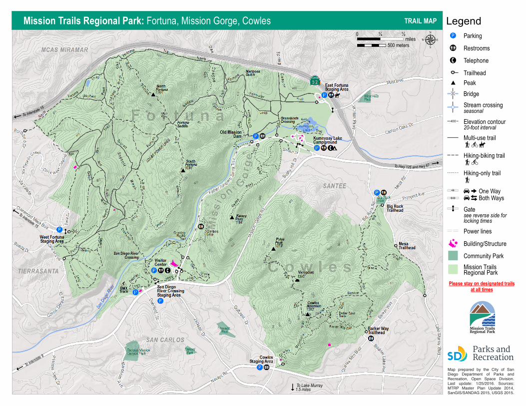
µLegendMission Trails Regional Park: Fortuna, Mission Gorge, Cowles TRAIL MAP
To Lake Murray1.5 miles
ParkingOP
Restrooms"!%(%Telephone●ÚTrailhead
Hiking-only trailå
U
ä
[
ä
Mission TrailsRegional Park
Community Park
Building/Structure
Power lines
Gatesee reverse side forlocking times
Õ
Hiking-biking trailåæ
Multi-use trailåæç
Elevation contour20-foot interval
400
Stream crossingseasonal
Bridge×
å
To Interstate 8
To Interstate 15
To Hwy 125 and Hwy 67
To Interstate 15
miles0 ½¼
500 meters
Please stay on designated trailsat all times
Map prepared by the City of San Diego Department of Park & Recreation, Open Space Division. Last update: 1/25/2016. Sources: MTRP Master Plan Update 2014, SanGIS/SANDAG 2015, USGS 2015.
One WayBoth WaysU
# Peak
Map prepared by the City of San Diego Department of Parks and Recreation, Open Space Division.Last update: 1/25/2016. Sources:MTRP Master Plan Update 2014,SanGIS/SANDAG 2015, USGS 2015.
Mission TrailsRegional Park
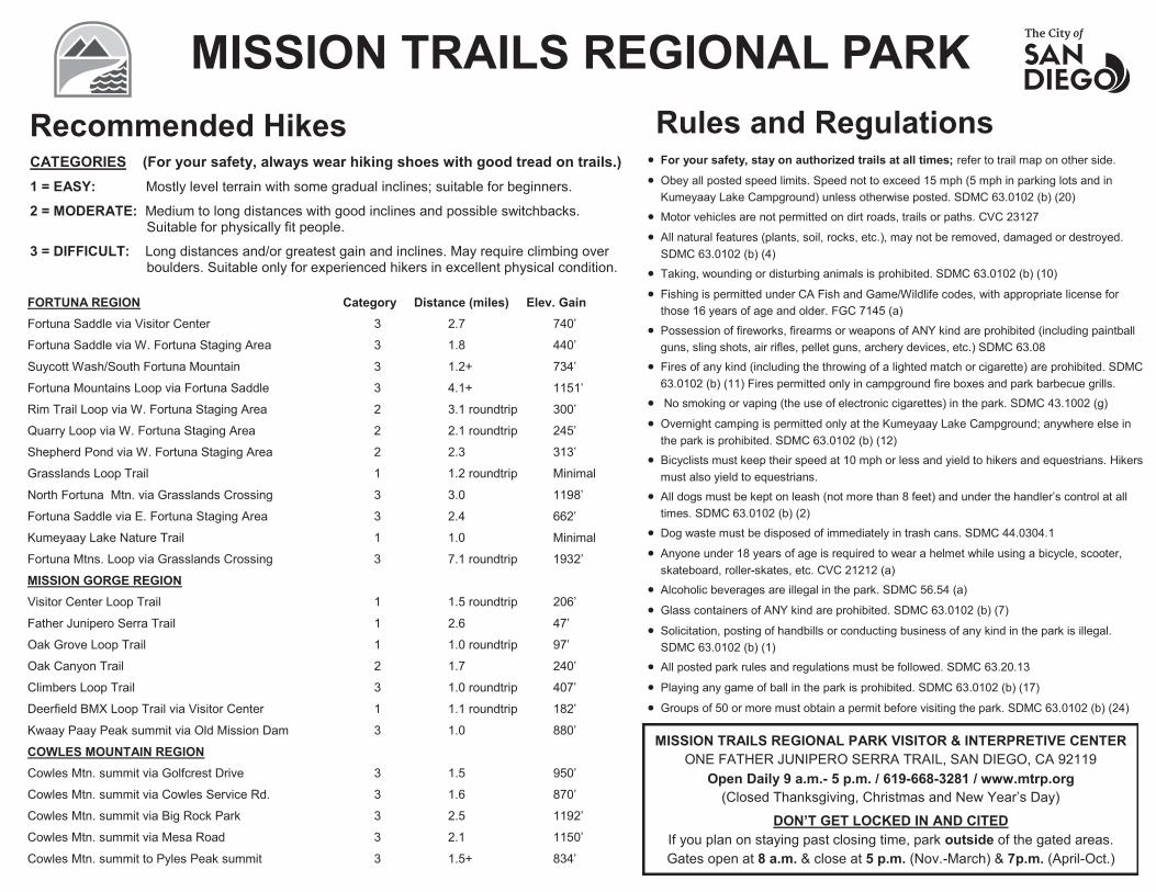
MISSION TRAILS REGIONAL PARK Rules and Regulations Recommended Hikes
CATEGORIES (For your safety, always wear hiking shoes with good tread on trails.)
1 = EASY: Mostly level terrain with some gradual inclines; suitable for beginners.
2 = MODERATE: Medium to long distances with good inclines and possible switchbacks. Suitable for physically fit people.
3 = DIFFICULT: Long distances and/or greatest gain and inclines. May require climbing over boulders. Suitable only for experienced hikers in excellent physical condition.
FORTUNA REGION Category Distance (miles) Elev. Gain Fortuna Saddle via Visitor Center 3 2.7 740’
Fortuna Saddle via W. Fortuna Staging Area 3 1.8 440’
Suycott Wash/South Fortuna Mountain 3 1.2+ 734’
Fortuna Mountains Loop via Fortuna Saddle 3 4.1+ 1151’
Rim Trail Loop via W. Fortuna Staging Area 2 3.1 roundtrip 300’
Quarry Loop via W. Fortuna Staging Area 2 2.1 roundtrip 245’
Shepherd Pond via W. Fortuna Staging Area 2 2.3 313’
Grasslands Loop Trail 1 1.2 roundtrip Minimal
North Fortuna Mtn. via Grasslands Crossing 3 3.0 1198’
Fortuna Saddle via E. Fortuna Staging Area 3 2.4 662’
Kumeyaay Lake Nature Trail 1 1.0 Minimal
Fortuna Mtns. Loop via Grasslands Crossing 3 7.1 roundtrip 1932’
MISSION GORGE REGION Visitor Center Loop Trail 1 1.5 roundtrip 206’
Father Junipero Serra Trail 1 2.6 47’
Oak Grove Loop Trail 1 1.0 roundtrip 97’
Oak Canyon Trail 2 1.7 240’
Climbers Loop Trail 3 1.0 roundtrip 407’
Deerfield BMX Loop Trail via Visitor Center 1 1.1 roundtrip 182’
Kwaay Paay Peak summit via Old Mission Dam 3 1.0 880’
COWLES MOUNTAIN REGION Cowles Mtn. summit via Golfcrest Drive 3 1.5 950’
Cowles Mtn. summit via Cowles Service Rd. 3 1.6 870’
Cowles Mtn. summit via Big Rock Park 3 2.5 1192’
Cowles Mtn. summit via Mesa Road 3 2.1 1150’ Cowles Mtn. summit to Pyles Peak summit 3 1.5+ 834’
For your safety, stay on authorized trails at all times; refer to trail map on other side.
Obey all posted speed limits. Speed not to exceed 15 mph (5 mph in parking lots and in Kumeyaay Lake Campground) unless otherwise posted. SDMC 63.0102 (b) (20)
Motor vehicles are not permitted on dirt roads, trails or paths. CVC 23127
All natural features (plants, soil, rocks, etc.), may not be removed, damaged or destroyed. SDMC 63.0102 (b) (4)
Taking, wounding or disturbing animals is prohibited. SDMC 63.0102 (b) (10)
Fishing is permitted under CA Fish and Game/Wildlife codes, with appropriate license for those 16 years of age and older. FGC 7145 (a)
Possession of fireworks, firearms or weapons of ANY kind are prohibited (including paintball guns, sling shots, air rifles, pellet guns, archery devices, etc.) SDMC 63.08
Fires of any kind (including the throwing of a lighted match or cigarette) are prohibited. SDMC 63.0102 (b) (11) Fires permitted only in campground fire boxes and park barbecue grills.
No smoking or vaping (the use of electronic cigarettes) in the park. SDMC 43.1002 (g)
Overnight camping is permitted only at the Kumeyaay Lake Campground; anywhere else in the park is prohibited. SDMC 63.0102 (b) (12)
Bicyclists must keep their speed at 10 mph or less and yield to hikers and equestrians. Hikers must also yield to equestrians.
All dogs must be kept on leash (not more than 8 feet) and under the handler’s control at all times. SDMC 63.0102 (b) (2)
Dog waste must be disposed of immediately in trash cans. SDMC 44.0304.1
Anyone under 18 years of age is required to wear a helmet while using a bicycle, scooter, skateboard, roller-skates, etc. CVC 21212 (a)
Alcoholic beverages are illegal in the park. SDMC 56.54 (a)
Glass containers of ANY kind are prohibited. SDMC 63.0102 (b) (7)
Solicitation, posting of handbills or conducting business of any kind in the park is illegal. SDMC 63.0102 (b) (1)
All posted park rules and regulations must be followed. SDMC 63.20.13
Playing any game of ball in the park is prohibited. SDMC 63.0102 (b) (17)
Groups of 50 or more must obtain a permit before visiting the park. SDMC 63.0102 (b) (24)
MISSION TRAILS REGIONAL PARK VISITOR & INTERPRETIVE CENTER ONE FATHER JUNIPERO SERRA TRAIL, SAN DIEGO, CA 92119
Open Daily 9 a.m.- 5 p.m. / 619-668-3281 / www.mtrp.org (Closed Thanksgiving, Christmas and New Year’s Day)
DON’T GET LOCKED IN AND CITED If you plan on staying past closing time, park outside of the gated areas. Gates open at 8 a.m. & close at 5 p.m. (Nov.-March) & 7p.m. (April-Oct.)