Embed Size (px)
Citation preview
Pacific Coast Archaeological Society Quarterly, Volume 33, Number 4, Fall 1997
Mission San Antonio de Padua ArchaeologicalField School Excavations of 1993, 1994, and 1996
Luther Bertrando
AbstractTwo areas of excavation at the Archaeological Field School during the 1993, 1994, and 1996seasons focused attention on those years just prior to secularization (1833) and reveal thatliving conditions at Mission San Antonio de Padua, as well as the expectations of the mission-aries, were at a high level during a time when most missions in Upper California were in astagnant state (Engelhardt 1972:48).
AbstractoDos areas de excavaciones hechas en la escuela de arqueologico de campo durante lasestaciones 1993, 1994, y 1996 fueron enfocados con atencion durante esos anos de previacecularizacion (1833) donde revelan las condiciones de vida de la Mision San Antonio dePadua, a igual que las expectaciones de los misioneros, manteniendose a un alto nivel duranteun tiempo cuando la mayoria de misiones en Alta California estuvieron en un estado dedecadencia.
Introduction
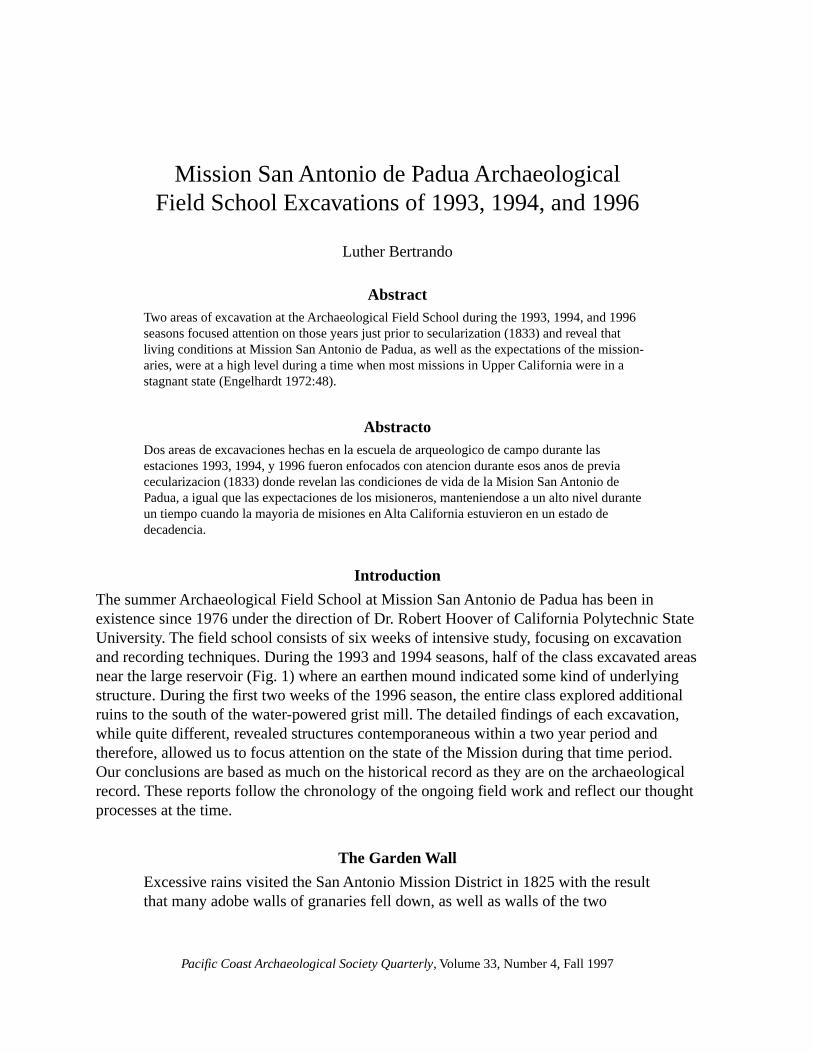
The summer Archaeological Field School at Mission San Antonio de Padua has been inexistence since 1976 under the direction of Dr. Robert Hoover of California Polytechnic StateUniversity. The field school consists of six weeks of intensive study, focusing on excavationand recording techniques. During the 1993 and 1994 seasons, half of the class excavated areasnear the large reservoir (Fig. 1) where an earthen mound indicated some kind of underlyingstructure. During the first two weeks of the 1996 season, the entire class explored additionalruins to the south of the water-powered grist mill. The detailed findings of each excavation,while quite different, revealed structures contemporaneous within a two year period andtherefore, allowed us to focus attention on the state of the Mission during that time period.Our conclusions are based as much on the historical record as they are on the archaeologicalrecord. These reports follow the chronology of the ongoing field work and reflect our thoughtprocesses at the time.
The Garden Wall
Excessive rains visited the San Antonio Mission District in 1825 with the resultthat many adobe walls of granaries fell down, as well as walls of the two
58
PCAS Quarterly, 33(4), Fall 1997
Luther Bertrando
gardens and one corral, altogether as many as 762 feet of walls. A corridor withits crib for feeding horses, and twenty-eight varas or seventy-nine feet alsocame down. Another porch or corridor was built the roof resting on oak pillarsor posts. All the ruined portions were restored, given good foundations andcovered with tiles. (Engelhardt 1972:45)
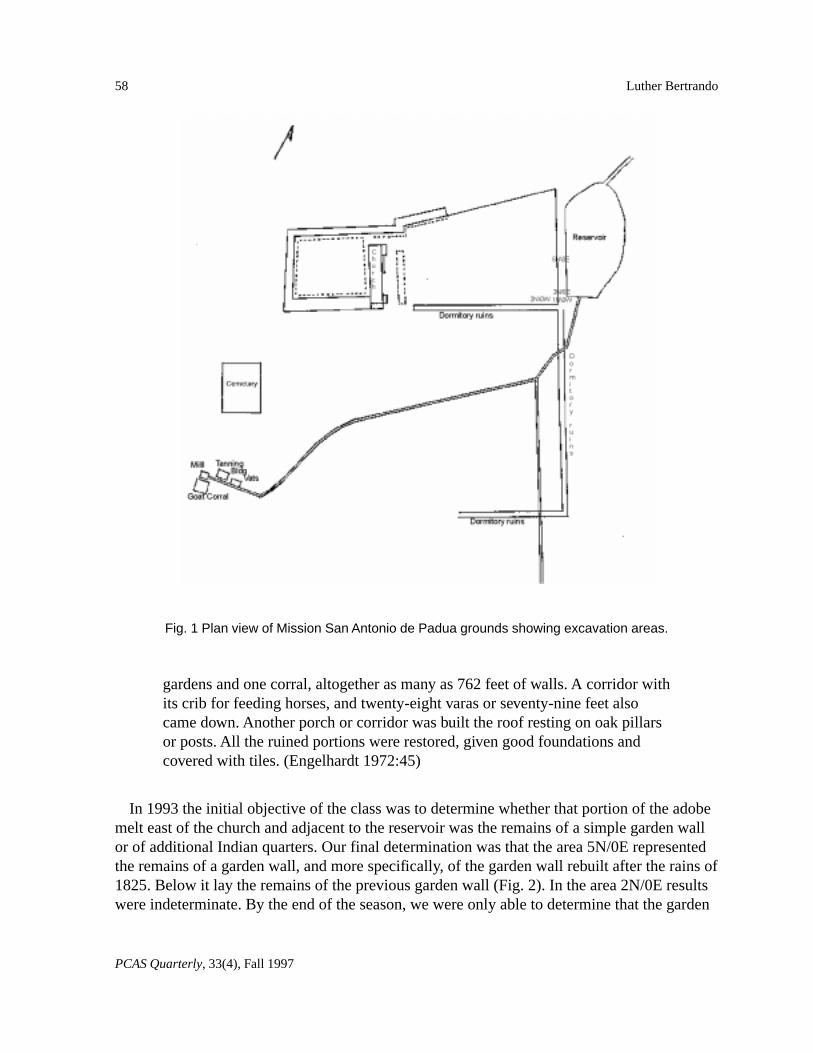
In 1993 the initial objective of the class was to determine whether that portion of the adobemelt east of the church and adjacent to the reservoir was the remains of a simple garden wallor of additional Indian quarters. Our final determination was that the area 5N/0E representedthe remains of a garden wall, and more specifically, of the garden wall rebuilt after the rains of1825. Below it lay the remains of the previous garden wall (Fig. 2). In the area 2N/0E resultswere indeterminate. By the end of the season, we were only able to determine that the garden
Fig. 1 Plan view of Mission San Antonio de Padua grounds showing excavation areas.
59
PCAS Quarterly, 33(4), Fall 1997
Mission San Antonio de Padua Field School Excavations
wall foundation did indeed continue in this area and that some cooking and living areas werelocated within the garden or “orchard” area. The relationship of the findings to the flooding of1825 is crucial to the understanding of the archaeology of this area. Subsequent findings wereinterpreted based upon the assumption that we had indeed encountered the results of the 1825flooding destruction.
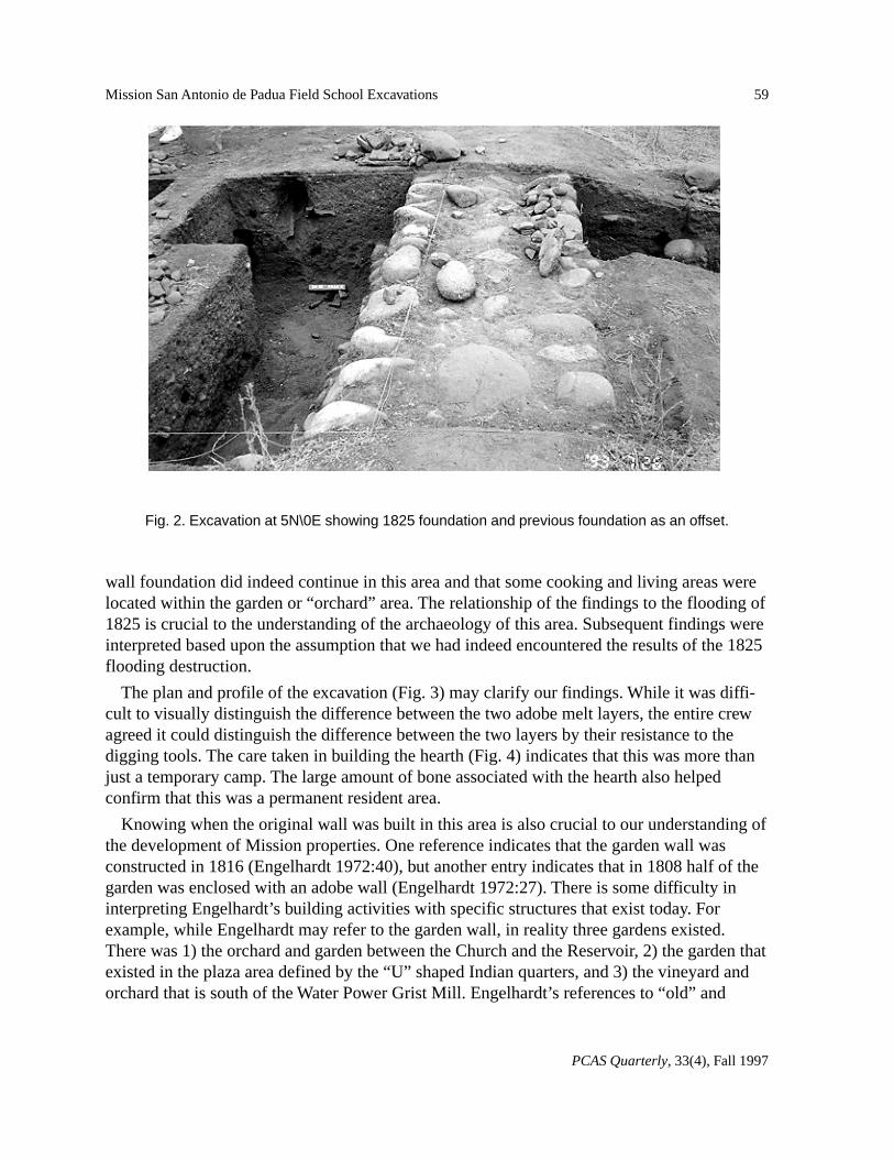
The plan and profile of the excavation (Fig. 3) may clarify our findings. While it was diffi-cult to visually distinguish the difference between the two adobe melt layers, the entire crewagreed it could distinguish the difference between the two layers by their resistance to thedigging tools. The care taken in building the hearth (Fig. 4) indicates that this was more thanjust a temporary camp. The large amount of bone associated with the hearth also helpedconfirm that this was a permanent resident area.
Knowing when the original wall was built in this area is also crucial to our understanding ofthe development of Mission properties. One reference indicates that the garden wall wasconstructed in 1816 (Engelhardt 1972:40), but another entry indicates that in 1808 half of thegarden was enclosed with an adobe wall (Engelhardt 1972:27). There is some difficulty ininterpreting Engelhardt’s building activities with specific structures that exist today. Forexample, while Engelhardt may refer to the garden wall, in reality three gardens existed.There was 1) the orchard and garden between the Church and the Reservoir, 2) the garden thatexisted in the plaza area defined by the “U” shaped Indian quarters, and 3) the vineyard andorchard that is south of the Water Power Grist Mill. Engelhardt’s references to “old” and
Fig. 2. Excavation at 5N\0E showing 1825 foundation and previous foundation as an offset.
60
PCAS Quarterly, 33(4), Fall 1997
Luther Bertrando
Fig. 3. Final excavation plan and profile for 5N/0E.
Fig. 4. Hearth at 5N/0E.
61
PCAS Quarterly, 33(4), Fall 1997
Mission San Antonio de Padua Field School Excavations
“new” gardens do little to clarify the architectural history of the Mission. We are thereforeconfronted with the puzzle of identifying specific structures that we find in an archaeologicalcontext with Engelhardt’s sometimes ambiguous references.
Our interpretation indicates the garden wall bordering the reservoir existed for at least nineyears before parts of it were destroyed by the heavy rains of 1825. The area north of the grid2N/0E was the area of destruction. The original wall south of the 2N grid-line did not collapsefrom water damage. While the 1993 season produced only inconclusive findings for this area,the 1994 crew was able to expose part of the original wall. The footing suggested that this wasthe original wall because it was constructed with the smaller river cobbles found in the under-lying foundation at 5N/0E. It was also at a lower depth than the new foundation at 5N/0E.Furthermore, by exposing the footings at the juncture of the garden wall with the north wall ofthe Indian quarters, it was found that the structure’s footings came up to and abutted thegarden wall footings. Therefore, the excavation verified that the structure had been con-structed later than the garden wall. The footings indicated that the garden wall was used as theterminus wall of the Indian quarters wing. If this garden wall had been built in 1816, the datewould be in conflict with the apparent sequence of construction since it appears from Engel-hardt that most of the houses for Indian neophyte families were constructed by 1810. Theseventy plus apartments we can calculate from Engelhardt’s analysis agrees with the numberof apartments we can calculate from the ruins that can be seen today. The original garden wallnext to the large reservoir must be the one reported by Engelhardt as built in 1808.
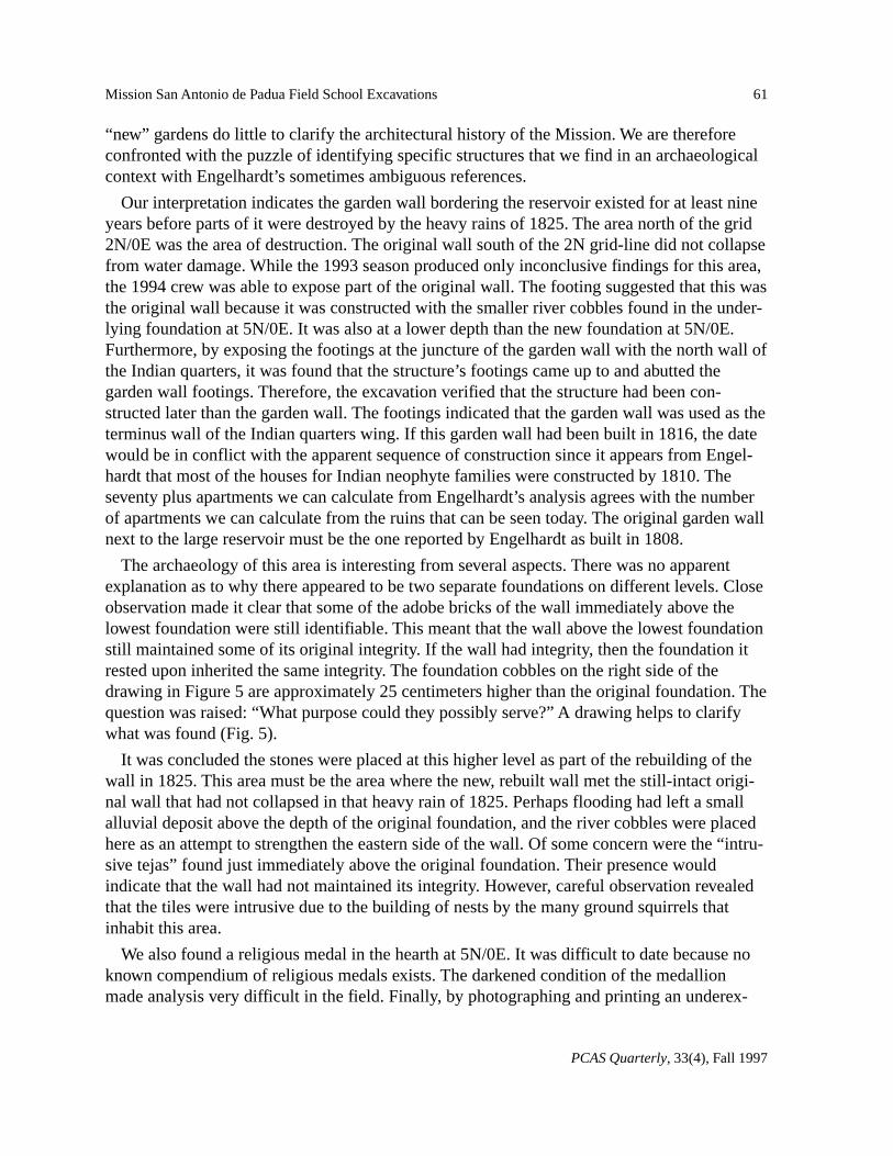
The archaeology of this area is interesting from several aspects. There was no apparentexplanation as to why there appeared to be two separate foundations on different levels. Closeobservation made it clear that some of the adobe bricks of the wall immediately above thelowest foundation were still identifiable. This meant that the wall above the lowest foundationstill maintained some of its original integrity. If the wall had integrity, then the foundation itrested upon inherited the same integrity. The foundation cobbles on the right side of thedrawing in Figure 5 are approximately 25 centimeters higher than the original foundation. Thequestion was raised: “What purpose could they possibly serve?” A drawing helps to clarifywhat was found (Fig. 5).
It was concluded the stones were placed at this higher level as part of the rebuilding of thewall in 1825. This area must be the area where the new, rebuilt wall met the still-intact origi-nal wall that had not collapsed in that heavy rain of 1825. Perhaps flooding had left a smallalluvial deposit above the depth of the original foundation, and the river cobbles were placedhere as an attempt to strengthen the eastern side of the wall. Of some concern were the “intru-sive tejas” found just immediately above the original foundation. Their presence wouldindicate that the wall had not maintained its integrity. However, careful observation revealedthat the tiles were intrusive due to the building of nests by the many ground squirrels thatinhabit this area.
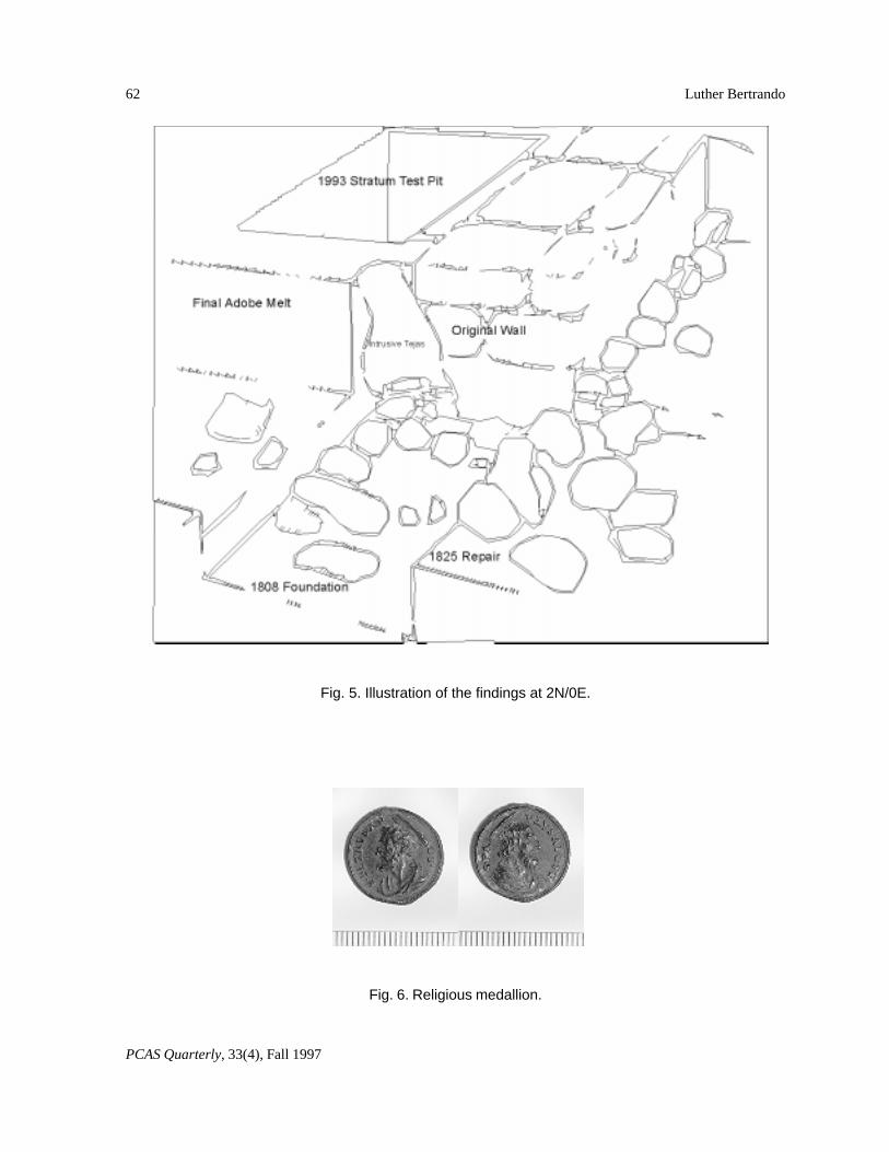
We also found a religious medal in the hearth at 5N/0E. It was difficult to date because noknown compendium of religious medals exists. The darkened condition of the medallionmade analysis very difficult in the field. Finally, by photographing and printing an underex-
62
PCAS Quarterly, 33(4), Fall 1997
Luther Bertrando
Fig. 5. Illustration of the findings at 2N/0E.
Fig. 6. Religious medallion.
63
PCAS Quarterly, 33(4), Fall 1997
Mission San Antonio de Padua Field School Excavations
posed positive, it was possible to get a good reading of the medal’s two faces (Fig. 6). Theapostle St. Paul is on one side and the apostle St. Peter on the obverse. The inscriptions readS.PA VLVS.APOST and S.PETRVS.AP OS. respectively. At this time the religious medaldoes not add confirmation of our conclusion that we are dealing with the destruction of thispart of the wall in 1825. If this medal can be shown to have an origin in Spain rather than inMexico, then we can assume that it was probably distributed prior to 1821, the date ofMexico’s independence from Spain (Engelhardt 1972:55). While the Franciscan Missionaries,Sancho and Cabot, who were serving at Mission San Antonio at this time, would not give anunconditional oath of allegiance to the Mexican government and were therefore subject toexile, no action was ever taken against them because no substitutes for them could be found(Engelhardt 1972:55). In fact, Father Sancho remained at the Mission until his death in 1830and was buried in the church next to the graves of his predecessors, Fathers Pujol and Sitjar(Engelhardt 1972:111).
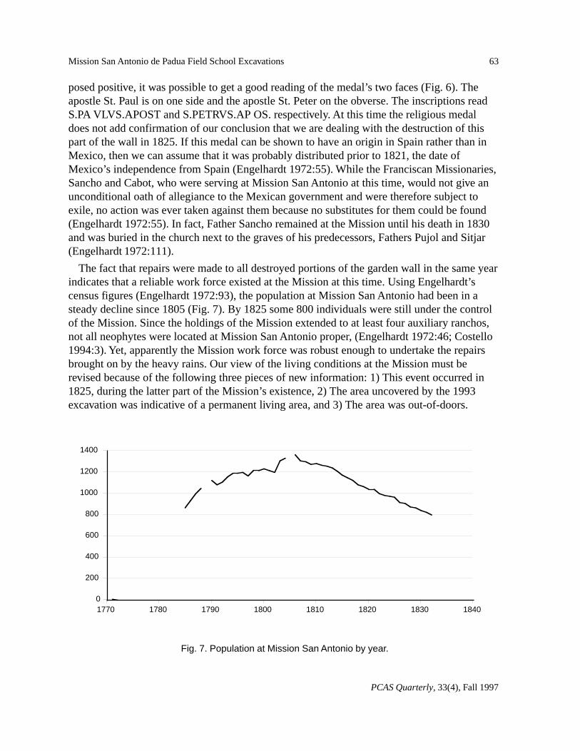
The fact that repairs were made to all destroyed portions of the garden wall in the same yearindicates that a reliable work force existed at the Mission at this time. Using Engelhardt’scensus figures (Engelhardt 1972:93), the population at Mission San Antonio had been in asteady decline since 1805 (Fig. 7). By 1825 some 800 individuals were still under the controlof the Mission. Since the holdings of the Mission extended to at least four auxiliary ranchos,not all neophytes were located at Mission San Antonio proper, (Engelhardt 1972:46; Costello1994:3). Yet, apparently the Mission work force was robust enough to undertake the repairsbrought on by the heavy rains. Our view of the living conditions at the Mission must berevised because of the following three pieces of new information: 1) This event occurred in1825, during the latter part of the Mission’s existence, 2) The area uncovered by the 1993excavation was indicative of a permanent living area, and 3) The area was out-of-doors.
Fig. 7. Population at Mission San Antonio by year.
1400
1200
1000
800
600
400
200
018401830182018101800179017801770
64
PCAS Quarterly, 33(4), Fall 1997
Luther Bertrando
Outdoor areas, not associated with Indian quarters, must have been one mode of accommodat-ing the native population even into the later stages of the Mission’s existence.
The following are implications from these findings:
1) In 1825, just seven years before Secularization, the Mission population was robust withover 800 neophytes in residence, and building activities were vigorous according to theannual reports. The fact that in 1825 a living area existed in the “orchard” area indicates thatexisting adobe quarters at the Mission were well occupied. The results of extensive damagewithin the same year also adds credence to the viability of the Mission at that time. Since therainy season is from October to April, we can assume that the storm that caused the damageoccurred very early in the year, perhaps January or February. Only a late rain in the rainyseason would have allowed sufficient time for repairs to have been made in the same year.
2) We know that the population reached its peak at the Mission about 1805. Engelhardtindicates that in 1780 only 16 houses for the Indians had been built. In 1805 and 1806 addi-tional houses were built, but the exact number is not known. We can expect that at theMission’s population peak, the number of adobe structures to house the Indians was fewerthan required by the population. I think it is safe to conclude that native structures must havebeen constructed to house some of the Mission population. We can at least infer that someovercrowding may have occurred.
3) The size of the rooms excavated during the 1994 season measured 5 by 6 varas (13 x 16ft.). Therefore, the approximately 1550 linear feet of Indian quarters shown on most maps ofthe Mission San Antonio indicates that approximately 80 rooms existed in the large U-shapedbuilding defining the plaza area. With an estimation from Fig. 7 and with the mid-1820scensus listing 800 Mission neophytes with perhaps 100 to 150 living at the outlying ranchos,650 individuals would have resided in 80 available rooms for an average occupancy of eightindividuals per room. Considering that there were probably additional living areas such as the“unmarried” wings for the females and the males, one may estimate that there was enoughroom to accommodate the population at the Mission at six individuals per room. Rooms wereallocated to families. Our findings indicate that some of that population settled in the area nowknown as the orchard and garden.
Post Mission Evidence
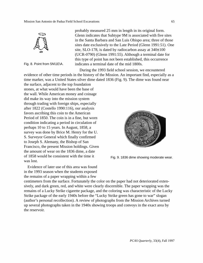
Exploration at 5N/1E/A, outside the garden area, exposed an area of hearth activity that wasinterpreted as representing a temporary camp site, probably post 1830s. The location of thishearth on the reservoir side of the garden wall may indicate that at the time of this temporaryencampment the reservoir still contained a supply of water. The small amount of bone foundcertainly indicates a temporary camp site. A very finely made small, tanged and eared chertpoint (Fig. 8) was found close to the hearth, indicating this camp site was aboriginal as op-posed to an Anglo camp site. The morphology of the point is a Gypsum Type or Brian Glenn’stype 9M (Glenn 1991:62). This type, while comparable with Greenwood’s (1972:16) Type 6a,has more prominent tangs, was very finely made, and although recovered in a broken state
65
PCAS Quarterly, 33(4), Fall 1997
Mission San Antonio de Padua Field School Excavations
probably measured 25 mm in length in its original form.Glenn indicates that Subtype 9M is associated with five sitesin the Santa Barbara and San Luis Obispo area; three of thosesites date exclusively to the Late Period (Glenn 1991:51). Onesite, SLO-178, is dated by radiocarbon assay at 340±100(UCR-0790) (Glenn 1991:55). Although a terminal date forthis type of point has not been established, this occurrenceindicates a terminal date of the mid 1800s.
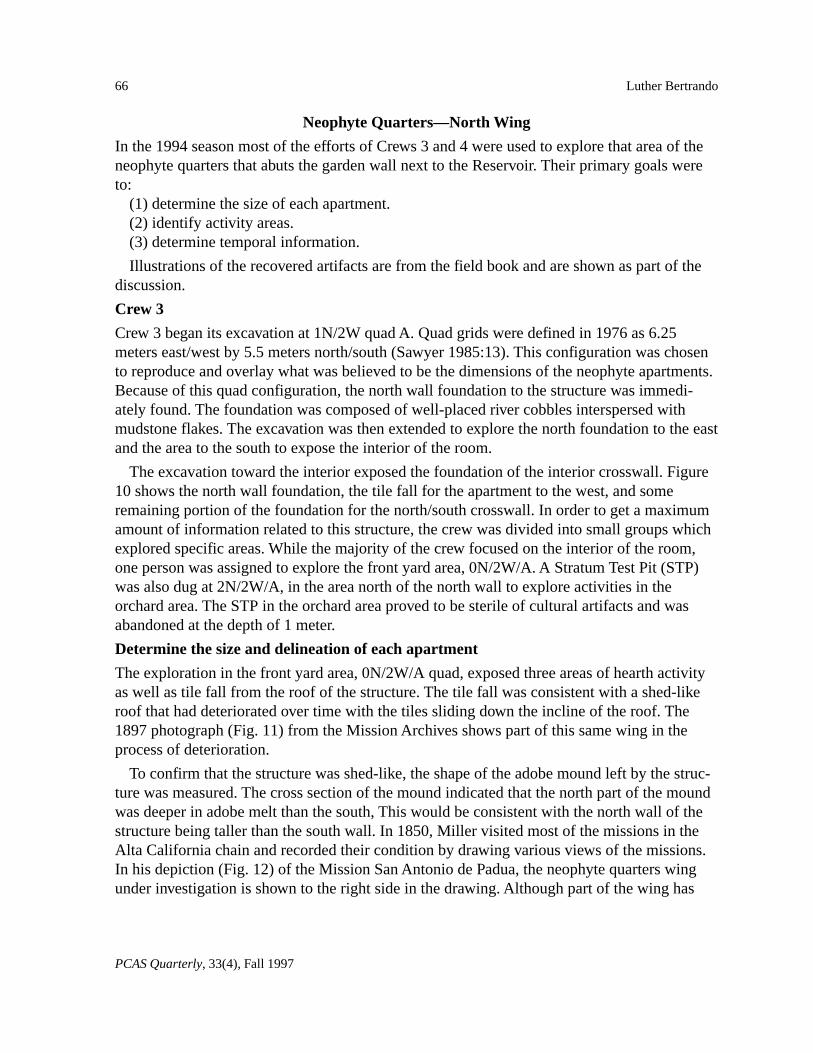
During the 1993 field school session, we encounteredevidence of other time periods in the history of the Mission. An important find, especially as atime marker, was a United States silver dime dated 1836 (Fig. 9). The dime was found nearthe surface, adjacent to the top foundationstones, at what would have been the base ofthe wall. While American money and coinagedid make its way into the mission systemthrough trading with foreign ships, especiallyafter 1822 (Costello 1990:116), our analysisfavors ascribing this coin to the AmericanPeriod of 1850. The coin is in a fine, but worncondition indicating a period in circulation ofperhaps 10 to 15 years. In August, 1858, asurvey was done by Brice M. Henry for the U.S. Surveyor General which finally confirmedto Joseph S. Alemany, the Bishop of SanFrancisco, the present Mission holdings. Giventhe amount of wear on the 1836 dime, a dateof 1858 would be consistent with the time itwas lost.
Evidence of later use of this area was foundin the 1993 season when the students exposedthe remains of a paper wrapping within a fewcentimeters from the surface. Fortunately the color on the paper had not deteriorated exten-sively, and dark green, red, and white were clearly discernible. The paper wrapping was theremains of a Lucky Strike cigarette package, and the coloring was characteristic of the LuckyStrike package of the early 1940s before the “Lucky Strike green has gone to war” slogan(author’s personal recollection). A review of photographs from the Mission Archives turnedup several photographs taken in the 1940s showing troops and convoys in the exact area bythe reservoir.
Fig. 9. 1836 dime showing moderate wear.
Fig. 8. Point from 5N\1E\A.
66
PCAS Quarterly, 33(4), Fall 1997
Luther Bertrando
Neophyte Quarters—North Wing
In the 1994 season most of the efforts of Crews 3 and 4 were used to explore that area of theneophyte quarters that abuts the garden wall next to the Reservoir. Their primary goals wereto:
(1) determine the size of each apartment.(2) identify activity areas.(3) determine temporal information.
Illustrations of the recovered artifacts are from the field book and are shown as part of thediscussion.
Crew 3
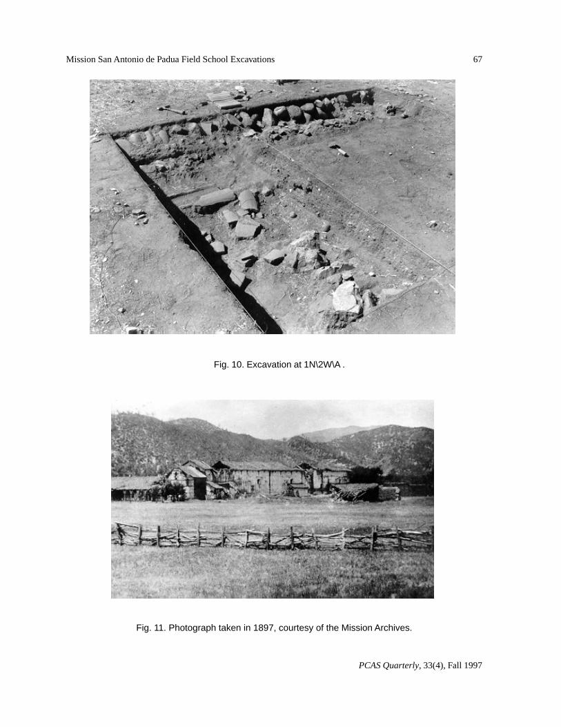
Crew 3 began its excavation at 1N/2W quad A. Quad grids were defined in 1976 as 6.25meters east/west by 5.5 meters north/south (Sawyer 1985:13). This configuration was chosento reproduce and overlay what was believed to be the dimensions of the neophyte apartments.Because of this quad configuration, the north wall foundation to the structure was immedi-ately found. The foundation was composed of well-placed river cobbles interspersed withmudstone flakes. The excavation was then extended to explore the north foundation to the eastand the area to the south to expose the interior of the room.
The excavation toward the interior exposed the foundation of the interior crosswall. Figure10 shows the north wall foundation, the tile fall for the apartment to the west, and someremaining portion of the foundation for the north/south crosswall. In order to get a maximumamount of information related to this structure, the crew was divided into small groups whichexplored specific areas. While the majority of the crew focused on the interior of the room,one person was assigned to explore the front yard area, 0N/2W/A. A Stratum Test Pit (STP)was also dug at 2N/2W/A, in the area north of the north wall to explore activities in theorchard area. The STP in the orchard area proved to be sterile of cultural artifacts and wasabandoned at the depth of 1 meter.
Determine the size and delineation of each apartment
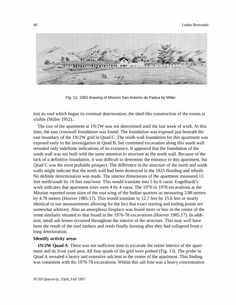
The exploration in the front yard area, 0N/2W/A quad, exposed three areas of hearth activityas well as tile fall from the roof of the structure. The tile fall was consistent with a shed-likeroof that had deteriorated over time with the tiles sliding down the incline of the roof. The1897 photograph (Fig. 11) from the Mission Archives shows part of this same wing in theprocess of deterioration.
To confirm that the structure was shed-like, the shape of the adobe mound left by the struc-ture was measured. The cross section of the mound indicated that the north part of the moundwas deeper in adobe melt than the south, This would be consistent with the north wall of thestructure being taller than the south wall. In 1850, Miller visited most of the missions in theAlta California chain and recorded their condition by drawing various views of the missions.In his depiction (Fig. 12) of the Mission San Antonio de Padua, the neophyte quarters wingunder investigation is shown to the right side in the drawing. Although part of the wing has
67
PCAS Quarterly, 33(4), Fall 1997
Mission San Antonio de Padua Field School Excavations
Fig. 10. Excavation at 1N\2W\A .
Fig. 11. Photograph taken in 1897, courtesy of the Mission Archives.
68
PCAS Quarterly, 33(4), Fall 1997
Luther Bertrando
lost its roof which began its eventual deterioration, the shed-like construction of the rooms isvisible (Miller 1952)..
The size of the apartment at 1N/2W was not determined until the last week of work. At thistime, the east crosswall foundation was found. The foundation was exposed just beneath theeast boundary of the 1N/2W grid in Quad C. The south wall foundation for this apartment wasexposed early in the investigation in Quad B, but continued excavation along this south wallrevealed only indefinite indications of its existence. It appeared that the foundation of thesouth wall was not built with the same attention to structure as the north wall. Because of thelack of a definitive foundation, it was difficult to determine the entrance to this apartment, butQuad C was the most probable prospect. The difference in the structure of the north and southwalls might indicate that the north wall had been destroyed in the 1825 flooding and rebuilt.No definite determination was made. The interior dimensions of the apartment measured 13feet north/south by 16 feet east/west. This would translate into 5 by 6 varas. Engelhardt’swork indicates that apartment sizes were 4 by 4 varas. The 1976 to 1978 excavations at theMission reported room sizes of the east wing of the Indian quarters as measuring 3.88 metersby 4.78 meters (Hoover 1985:17). This would translate to 12.7 feet by 15.6 feet or nearlyidentical to our measurements allowing for the fact that exact starting and ending points aresomewhat arbitrary. Also an amorphous fireplace was found more or less in the center of theroom similarly situated to that found in the 1976-78 excavations (Hoover 1985:17). In addi-tion, small ash lenses occurred throughout the interior of the structure. This may well havebeen the result of the roof timbers and reeds finally burning after they had collapsed from along deterioration.
Identify activity areas
1N/2W Quad A. There was not sufficient time to excavate the entire interior of the apart-ment and its front yard area. All four quads of the grid were probed (Fig. 13). The probe inQuad A revealed a heavy and extensive ash lens in the center of the apartment. This findingwas consistent with the 1976-78 excavations. Within this ash lens was a heavy concentration
Fig. 12. 1850 drawing of Mission San Antonio de Padua by Miller.
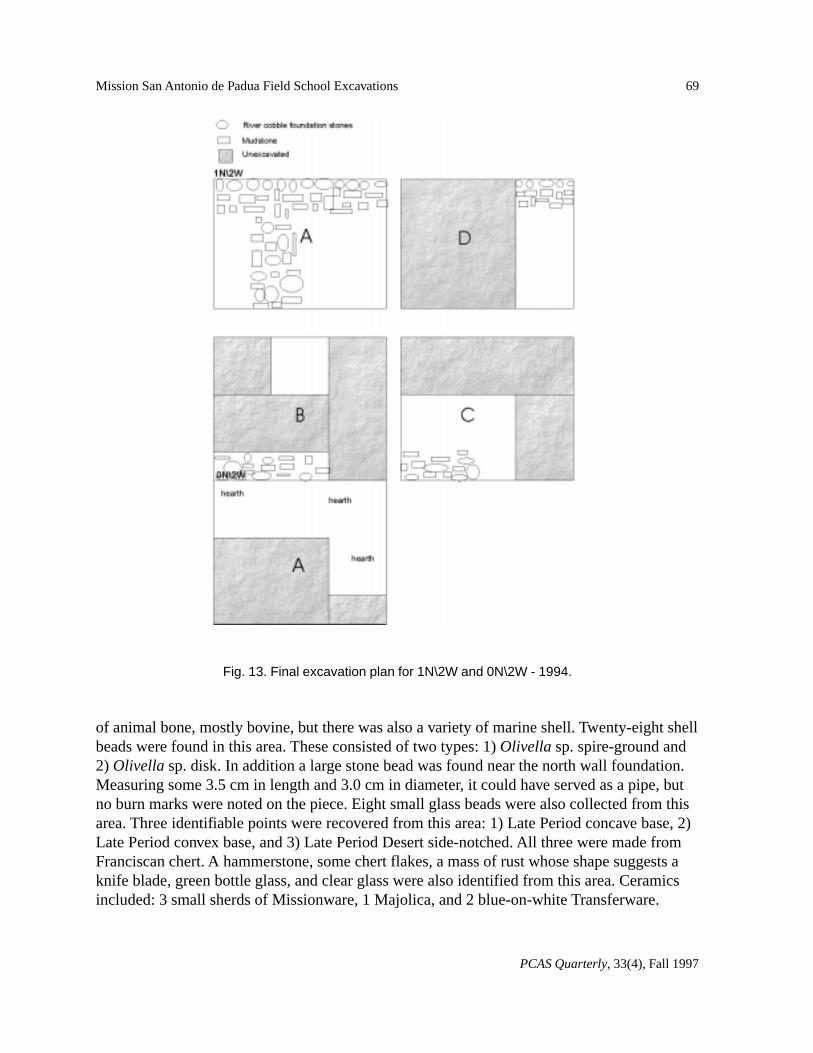
69
PCAS Quarterly, 33(4), Fall 1997
Mission San Antonio de Padua Field School Excavations
of animal bone, mostly bovine, but there was also a variety of marine shell. Twenty-eight shellbeads were found in this area. These consisted of two types: 1) Olivella sp. spire-ground and2) Olivella sp. disk. In addition a large stone bead was found near the north wall foundation.Measuring some 3.5 cm in length and 3.0 cm in diameter, it could have served as a pipe, butno burn marks were noted on the piece. Eight small glass beads were also collected from thisarea. Three identifiable points were recovered from this area: 1) Late Period concave base, 2)Late Period convex base, and 3) Late Period Desert side-notched. All three were made fromFranciscan chert. A hammerstone, some chert flakes, a mass of rust whose shape suggests aknife blade, green bottle glass, and clear glass were also identified from this area. Ceramicsincluded: 3 small sherds of Missionware, 1 Majolica, and 2 blue-on-white Transferware.
Fig. 13. Final excavation plan for 1N\2W and 0N\2W - 1994.
70
PCAS Quarterly, 33(4), Fall 1997
Luther Bertrando
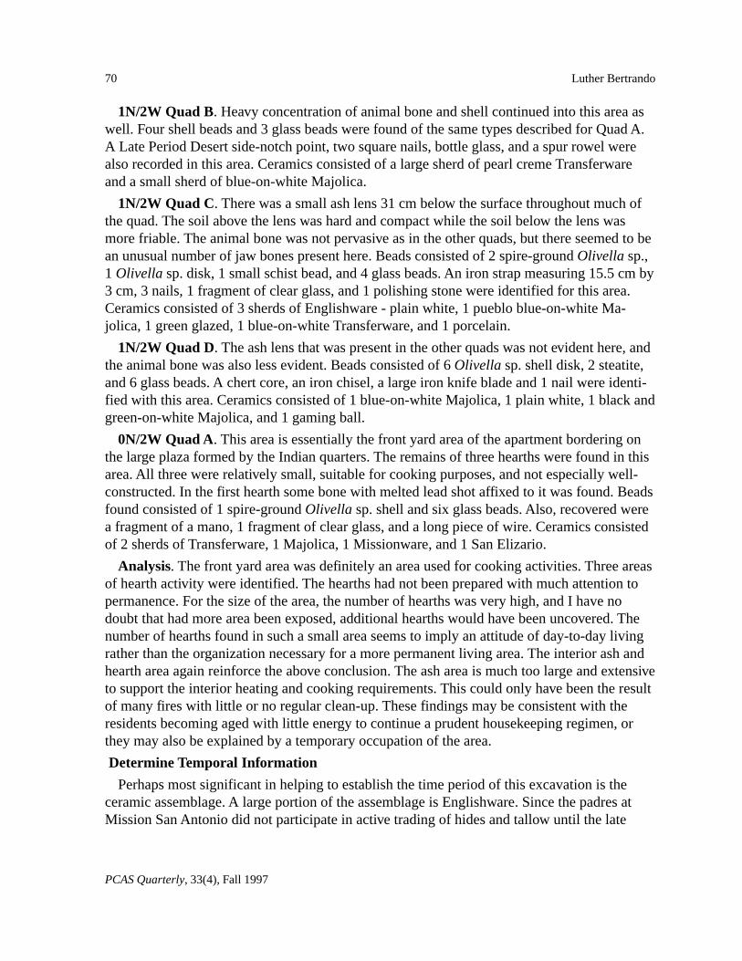
1N/2W Quad B. Heavy concentration of animal bone and shell continued into this area aswell. Four shell beads and 3 glass beads were found of the same types described for Quad A.A Late Period Desert side-notch point, two square nails, bottle glass, and a spur rowel werealso recorded in this area. Ceramics consisted of a large sherd of pearl creme Transferwareand a small sherd of blue-on-white Majolica.
1N/2W Quad C. There was a small ash lens 31 cm below the surface throughout much ofthe quad. The soil above the lens was hard and compact while the soil below the lens wasmore friable. The animal bone was not pervasive as in the other quads, but there seemed to bean unusual number of jaw bones present here. Beads consisted of 2 spire-ground Olivella sp.,1 Olivella sp. disk, 1 small schist bead, and 4 glass beads. An iron strap measuring 15.5 cm by3 cm, 3 nails, 1 fragment of clear glass, and 1 polishing stone were identified for this area.Ceramics consisted of 3 sherds of Englishware - plain white, 1 pueblo blue-on-white Ma-jolica, 1 green glazed, 1 blue-on-white Transferware, and 1 porcelain.
1N/2W Quad D. The ash lens that was present in the other quads was not evident here, andthe animal bone was also less evident. Beads consisted of 6 Olivella sp. shell disk, 2 steatite,and 6 glass beads. A chert core, an iron chisel, a large iron knife blade and 1 nail were identi-fied with this area. Ceramics consisted of 1 blue-on-white Majolica, 1 plain white, 1 black andgreen-on-white Majolica, and 1 gaming ball.
0N/2W Quad A. This area is essentially the front yard area of the apartment bordering onthe large plaza formed by the Indian quarters. The remains of three hearths were found in thisarea. All three were relatively small, suitable for cooking purposes, and not especially well-constructed. In the first hearth some bone with melted lead shot affixed to it was found. Beadsfound consisted of 1 spire-ground Olivella sp. shell and six glass beads. Also, recovered werea fragment of a mano, 1 fragment of clear glass, and a long piece of wire. Ceramics consistedof 2 sherds of Transferware, 1 Majolica, 1 Missionware, and 1 San Elizario.
Analysis. The front yard area was definitely an area used for cooking activities. Three areasof hearth activity were identified. The hearths had not been prepared with much attention topermanence. For the size of the area, the number of hearths was very high, and I have nodoubt that had more area been exposed, additional hearths would have been uncovered. Thenumber of hearths found in such a small area seems to imply an attitude of day-to-day livingrather than the organization necessary for a more permanent living area. The interior ash andhearth area again reinforce the above conclusion. The ash area is much too large and extensiveto support the interior heating and cooking requirements. This could only have been the resultof many fires with little or no regular clean-up. These findings may be consistent with theresidents becoming aged with little energy to continue a prudent housekeeping regimen, orthey may also be explained by a temporary occupation of the area.
Determine Temporal Information
Perhaps most significant in helping to establish the time period of this excavation is theceramic assemblage. A large portion of the assemblage is Englishware. Since the padres atMission San Antonio did not participate in active trading of hides and tallow until the late
71
PCAS Quarterly, 33(4), Fall 1997
Mission San Antonio de Padua Field School Excavations
1820s, it was only after this time that English ceramics were acquired for use in the Indian’sresidences (Costello 1990:388). Finding a spur rowel allows further refinement of the timeperiod. For many years the Indian neophytes were forbidden to ride horses. Indeed in Felipede Neve’s instructions to Fages he states:
The order should be repeated which I gave to those who tend the cattle and tothe soldiers who may be out with the horses or on other duties: they shouldtake away any halters or ropes carried by the Indians, heathen or Christian, taketheir names and report them to the presidio, on the supposition that Indianswould only be using halters and long ropes to catch cattle or horses. (Beilharz1971:160).
While eventually the Indian became an excellent vaquero, there are no reports of thisoccurring before the Mexican Period, and most likely the Indian vaquero acquired spurssometime after secularization, or post 1833.
The occurrence of melted lead shot in one of the front yard hearths also points to an occupa-tion period dating to the 1840s. The two most important weapons the Spanish soldier hadwere the horse and the gun. These would be the last two things the Indians could be expectedto acquire. The fact that even the possession of a gun was a rarity among the Indian popula-tion is supported by the fact that even at this late period there was a dependency on the bowand arrow as a weapon as indicated by the many arrow points that were uncovered in thisapartment. Therefore, this excavation deals with some of the last residents of the Mission.
Crew 4
As indicated in the above, the 1994 Crew 4 had resolved the problems left unanswered by the1993 Crew 4. The remainder of the term was used by Crew 4 to explore some of the interiorof the apartment at 1N/0W. While the findings from this apartment were similar to the find-ings at 1N/2W, the ash lens beneath the tile fall was thicker and the tile fall was at times up tofour layers deep. The members of Crew 4 considered this fact in conjunction with the lack ofpersonal items suggests that the apartment was destroyed by an intentionally set fire.
Identified activity areas
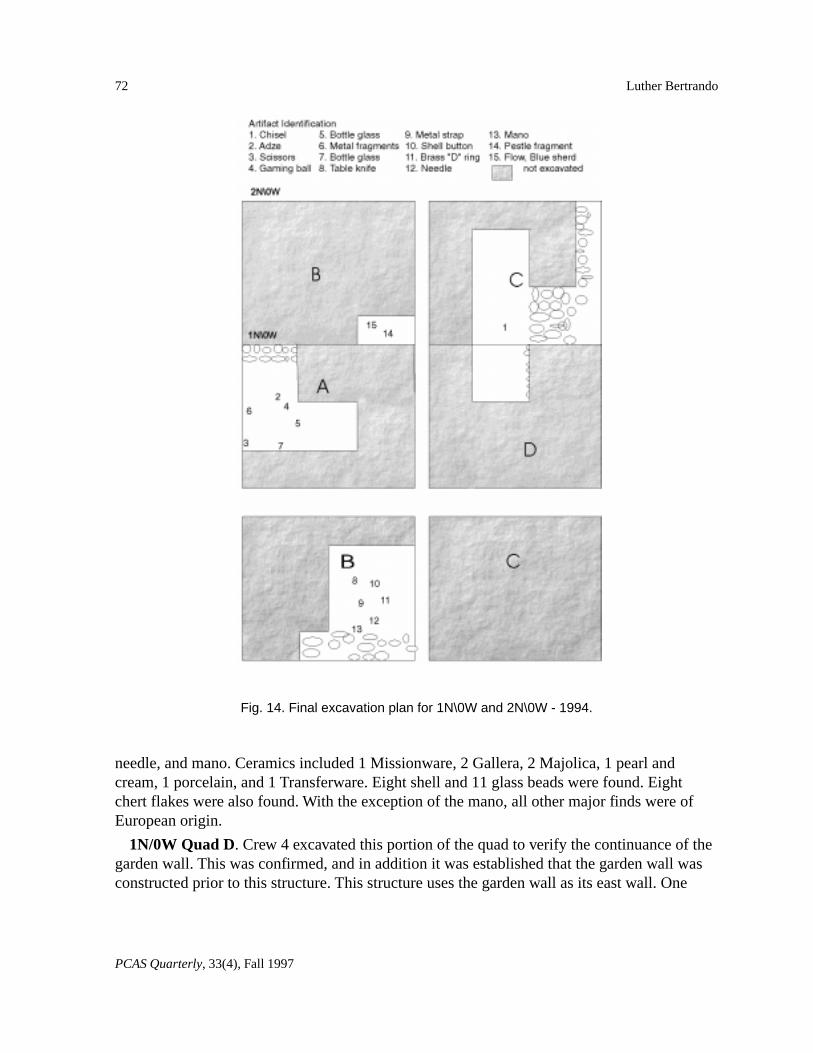
1N/0W Quad A. The excavation of this area began as an attempt to find the north wallfoundation of the structure. The foundation was found where it was projected to be, and wasan extension of the north wall foundation found at 1N/2W. Crew 4 then explored the areainterior to the north wall. A heavy layer of tile fall from the collapsed roof was removed.Beneath it lay a heavy layer of ash. Within this layer and just below it were found the follow-ing objects (see Fig. 14 for location of items): adze, scissors, gaming ball, 19 bottle glassfragments, and metal fragments. Ceramics consisted of 3 sherds of Missionware, 1 Majolica,and 1 porcelain. Nine shell and 15 glass beads were found in this area.
1N/0W Quad B. This quad was probed to identify the south wall foundation. The southwall foundation was found and was an extension of the south wall foundation at 1N/2W. Thefoundation was more definite in this area. The probe continued into the interior of the room.Objects found were: table knife, metal strap (plane blade), shell button, brass “D” ring,
72
PCAS Quarterly, 33(4), Fall 1997
Luther Bertrando
needle, and mano. Ceramics included 1 Missionware, 2 Gallera, 2 Majolica, 1 pearl andcream, 1 porcelain, and 1 Transferware. Eight shell and 11 glass beads were found. Eightchert flakes were also found. With the exception of the mano, all other major finds were ofEuropean origin.
1N/0W Quad D. Crew 4 excavated this portion of the quad to verify the continuance of thegarden wall. This was confirmed, and in addition it was established that the garden wall wasconstructed prior to this structure. This structure uses the garden wall as its east wall. One
Fig. 14. Final excavation plan for 1N\0W and 2N\0W - 1994.
73
PCAS Quarterly, 33(4), Fall 1997
Mission San Antonio de Padua Field School Excavations
porcelain sherd, one chert flake, one square nail, and one broken piece of bottle glass werefound in this area.
2N/0W Quad B. A small probing was made in this area primarily to confirm that the northwall foundation continued into this area. Probes in the south wall of the excavation pit con-firmed the existence of the foundation. A small garbage area was discovered here. Objectsfound were a pestle fragment and a sherd of flow-blue ceramic ware. A small cache of birdbone indicated the remains of some past meal.
Analysis. The usual ashy hearth found in the center of the adobe rooms was also presenthere with the addition of a more expansive ashy layer generally throughout the apartment. Nospecific area could be identified with a specific function.
Determine Temporal Information
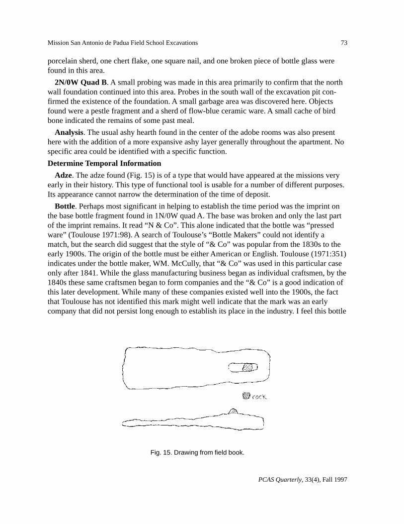
Adze. The adze found (Fig. 15) is of a type that would have appeared at the missions veryearly in their history. This type of functional tool is usable for a number of different purposes.Its appearance cannot narrow the determination of the time of deposit.
Bottle. Perhaps most significant in helping to establish the time period was the imprint onthe base bottle fragment found in 1N/0W quad A. The base was broken and only the last partof the imprint remains. It read “N & Co”. This alone indicated that the bottle was “pressedware” (Toulouse 1971:98). A search of Toulouse’s “Bottle Makers” could not identify amatch, but the search did suggest that the style of “& Co” was popular from the 1830s to theearly 1900s. The origin of the bottle must be either American or English. Toulouse (1971:351)indicates under the bottle maker, WM. McCully, that “& Co” was used in this particular caseonly after 1841. While the glass manufacturing business began as individual craftsmen, by the1840s these same craftsmen began to form companies and the “& Co” is a good indication ofthis later development. While many of these companies existed well into the 1900s, the factthat Toulouse has not identified this mark might well indicate that the mark was an earlycompany that did not persist long enough to establish its place in the industry. I feel this bottle
Fig. 15. Drawing from field book.
74
PCAS Quarterly, 33(4), Fall 1997
Luther Bertrando
may represent a time period of the 1840s to 1850s. Miller’s drawing from 1850 indicates thatbuildings farther from the Church were in a state of abandonment.
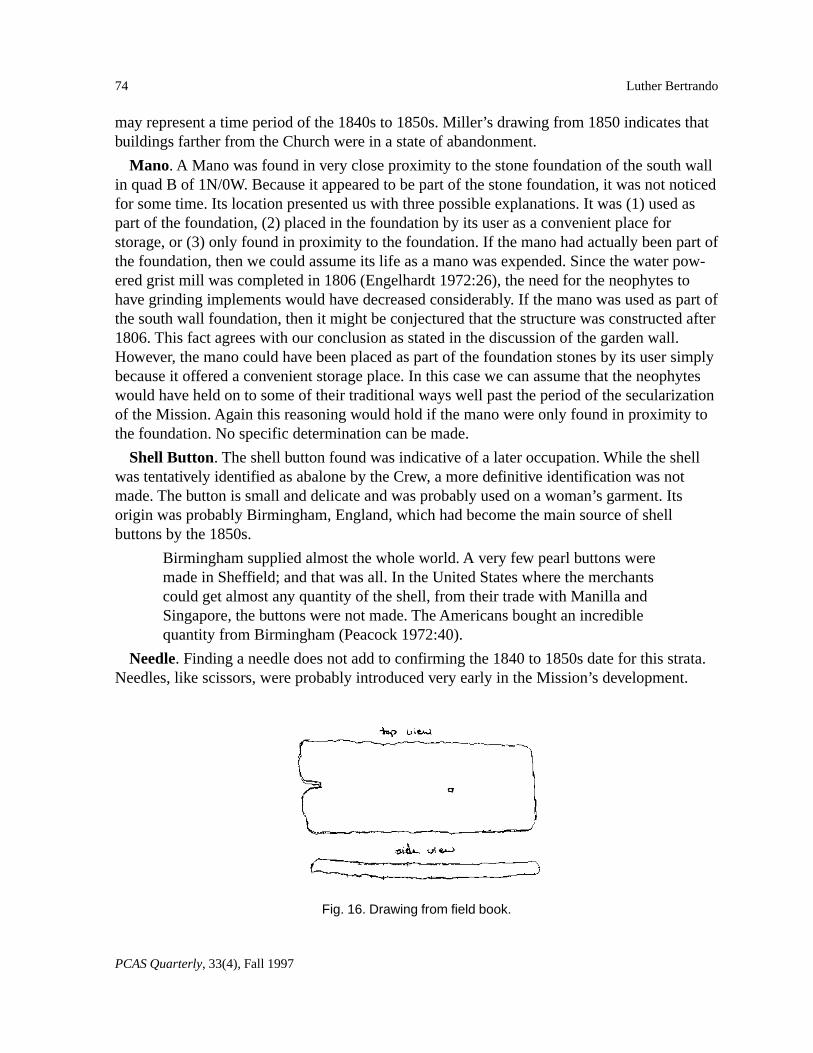
Mano. A Mano was found in very close proximity to the stone foundation of the south wallin quad B of 1N/0W. Because it appeared to be part of the stone foundation, it was not noticedfor some time. Its location presented us with three possible explanations. It was (1) used aspart of the foundation, (2) placed in the foundation by its user as a convenient place forstorage, or (3) only found in proximity to the foundation. If the mano had actually been part ofthe foundation, then we could assume its life as a mano was expended. Since the water pow-ered grist mill was completed in 1806 (Engelhardt 1972:26), the need for the neophytes tohave grinding implements would have decreased considerably. If the mano was used as part ofthe south wall foundation, then it might be conjectured that the structure was constructed after1806. This fact agrees with our conclusion as stated in the discussion of the garden wall.However, the mano could have been placed as part of the foundation stones by its user simplybecause it offered a convenient storage place. In this case we can assume that the neophyteswould have held on to some of their traditional ways well past the period of the secularizationof the Mission. Again this reasoning would hold if the mano were only found in proximity tothe foundation. No specific determination can be made.
Shell Button. The shell button found was indicative of a later occupation. While the shellwas tentatively identified as abalone by the Crew, a more definitive identification was notmade. The button is small and delicate and was probably used on a woman’s garment. Itsorigin was probably Birmingham, England, which had become the main source of shellbuttons by the 1850s.
Birmingham supplied almost the whole world. A very few pearl buttons weremade in Sheffield; and that was all. In the United States where the merchantscould get almost any quantity of the shell, from their trade with Manilla andSingapore, the buttons were not made. The Americans bought an incrediblequantity from Birmingham (Peacock 1972:40).
Needle. Finding a needle does not add to confirming the 1840 to 1850s date for this strata.Needles, like scissors, were probably introduced very early in the Mission’s development.
Fig. 16. Drawing from field book.
75
PCAS Quarterly, 33(4), Fall 1997
Mission San Antonio de Padua Field School Excavations
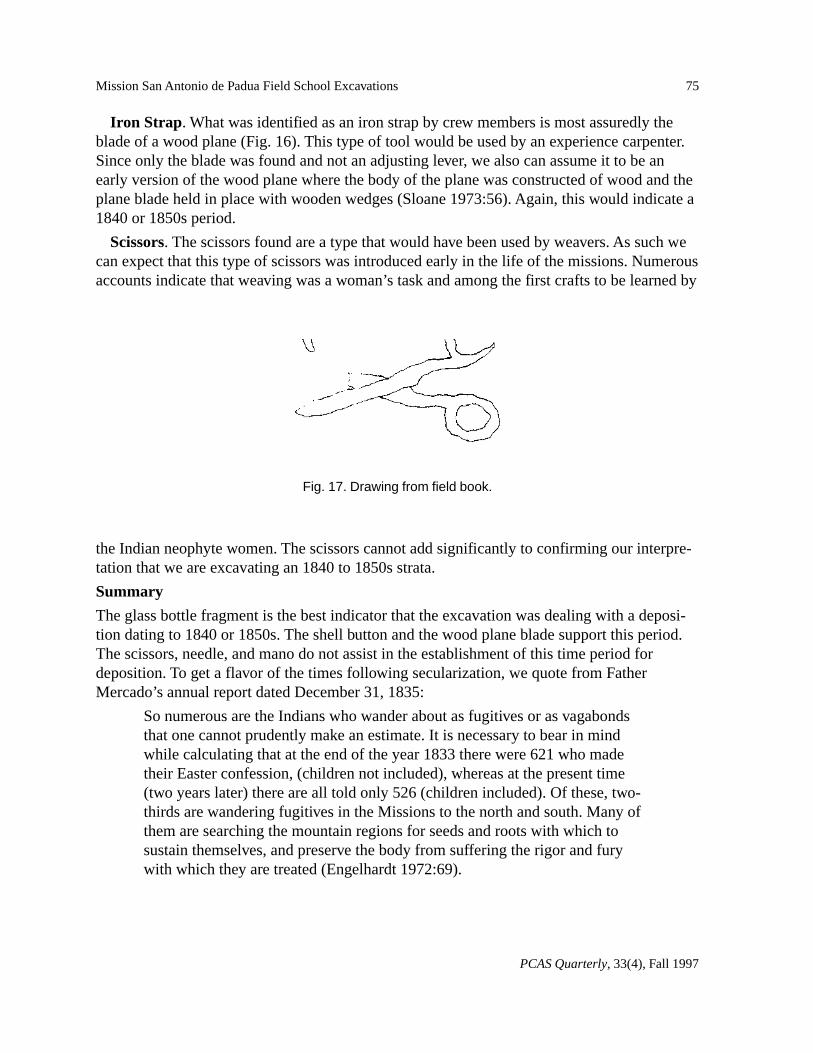
Iron Strap . What was identified as an iron strap by crew members is most assuredly theblade of a wood plane (Fig. 16). This type of tool would be used by an experience carpenter.Since only the blade was found and not an adjusting lever, we also can assume it to be anearly version of the wood plane where the body of the plane was constructed of wood and theplane blade held in place with wooden wedges (Sloane 1973:56). Again, this would indicate a1840 or 1850s period.
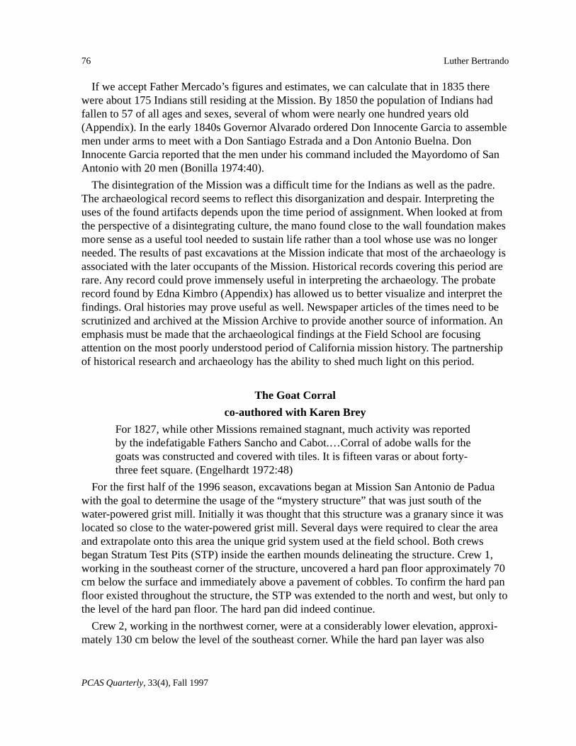
Scissors. The scissors found are a type that would have been used by weavers. As such wecan expect that this type of scissors was introduced early in the life of the missions. Numerousaccounts indicate that weaving was a woman’s task and among the first crafts to be learned by
the Indian neophyte women. The scissors cannot add significantly to confirming our interpre-tation that we are excavating an 1840 to 1850s strata.
Summary
The glass bottle fragment is the best indicator that the excavation was dealing with a deposi-tion dating to 1840 or 1850s. The shell button and the wood plane blade support this period.The scissors, needle, and mano do not assist in the establishment of this time period fordeposition. To get a flavor of the times following secularization, we quote from FatherMercado’s annual report dated December 31, 1835:
So numerous are the Indians who wander about as fugitives or as vagabondsthat one cannot prudently make an estimate. It is necessary to bear in mindwhile calculating that at the end of the year 1833 there were 621 who madetheir Easter confession, (children not included), whereas at the present time(two years later) there are all told only 526 (children included). Of these, two-thirds are wandering fugitives in the Missions to the north and south. Many ofthem are searching the mountain regions for seeds and roots with which tosustain themselves, and preserve the body from suffering the rigor and furywith which they are treated (Engelhardt 1972:69).
Fig. 17. Drawing from field book.
76
PCAS Quarterly, 33(4), Fall 1997
Luther Bertrando
If we accept Father Mercado’s figures and estimates, we can calculate that in 1835 therewere about 175 Indians still residing at the Mission. By 1850 the population of Indians hadfallen to 57 of all ages and sexes, several of whom were nearly one hundred years old(Appendix). In the early 1840s Governor Alvarado ordered Don Innocente Garcia to assemblemen under arms to meet with a Don Santiago Estrada and a Don Antonio Buelna. DonInnocente Garcia reported that the men under his command included the Mayordomo of SanAntonio with 20 men (Bonilla 1974:40).
The disintegration of the Mission was a difficult time for the Indians as well as the padre.The archaeological record seems to reflect this disorganization and despair. Interpreting theuses of the found artifacts depends upon the time period of assignment. When looked at fromthe perspective of a disintegrating culture, the mano found close to the wall foundation makesmore sense as a useful tool needed to sustain life rather than a tool whose use was no longerneeded. The results of past excavations at the Mission indicate that most of the archaeology isassociated with the later occupants of the Mission. Historical records covering this period arerare. Any record could prove immensely useful in interpreting the archaeology. The probaterecord found by Edna Kimbro (Appendix) has allowed us to better visualize and interpret thefindings. Oral histories may prove useful as well. Newspaper articles of the times need to bescrutinized and archived at the Mission Archive to provide another source of information. Anemphasis must be made that the archaeological findings at the Field School are focusingattention on the most poorly understood period of California mission history. The partnershipof historical research and archaeology has the ability to shed much light on this period.
The Goat Corral
co-authored with Karen Brey
For 1827, while other Missions remained stagnant, much activity was reportedby the indefatigable Fathers Sancho and Cabot.…Corral of adobe walls for thegoats was constructed and covered with tiles. It is fifteen varas or about forty-three feet square. (Engelhardt 1972:48)
For the first half of the 1996 season, excavations began at Mission San Antonio de Paduawith the goal to determine the usage of the “mystery structure” that was just south of thewater-powered grist mill. Initially it was thought that this structure was a granary since it waslocated so close to the water-powered grist mill. Several days were required to clear the areaand extrapolate onto this area the unique grid system used at the field school. Both crewsbegan Stratum Test Pits (STP) inside the earthen mounds delineating the structure. Crew 1,working in the southeast corner of the structure, uncovered a hard pan floor approximately 70cm below the surface and immediately above a pavement of cobbles. To confirm the hard panfloor existed throughout the structure, the STP was extended to the north and west, but only tothe level of the hard pan floor. The hard pan did indeed continue.
Crew 2, working in the northwest corner, were at a considerably lower elevation, approxi-mately 130 cm below the level of the southeast corner. While the hard pan layer was also
77
PCAS Quarterly, 33(4), Fall 1997
Mission San Antonio de Padua Field School Excavations
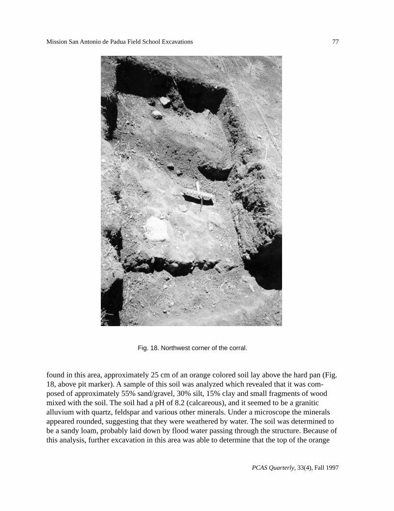
found in this area, approximately 25 cm of an orange colored soil lay above the hard pan (Fig.18, above pit marker). A sample of this soil was analyzed which revealed that it was com-posed of approximately 55% sand/gravel, 30% silt, 15% clay and small fragments of woodmixed with the soil. The soil had a pH of 8.2 (calcareous), and it seemed to be a graniticalluvium with quartz, feldspar and various other minerals. Under a microscope the mineralsappeared rounded, suggesting that they were weathered by water. The soil was determined tobe a sandy loam, probably laid down by flood water passing through the structure. Because ofthis analysis, further excavation in this area was able to determine that the top of the orange
Fig. 18. Northwest corner of the corral.
78
PCAS Quarterly, 33(4), Fall 1997
Luther Bertrando
layer was indeed level in all directions, a confirmation that the layer was the result of a flood-ing episode. The foundation stones of the western wall were found when the STP was ex-tended westward. The STP was then extended northward with the intent to articulate thenorthwest corner of the structure.
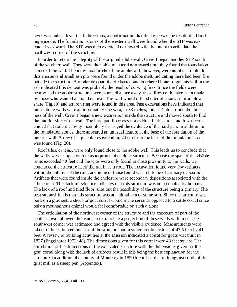
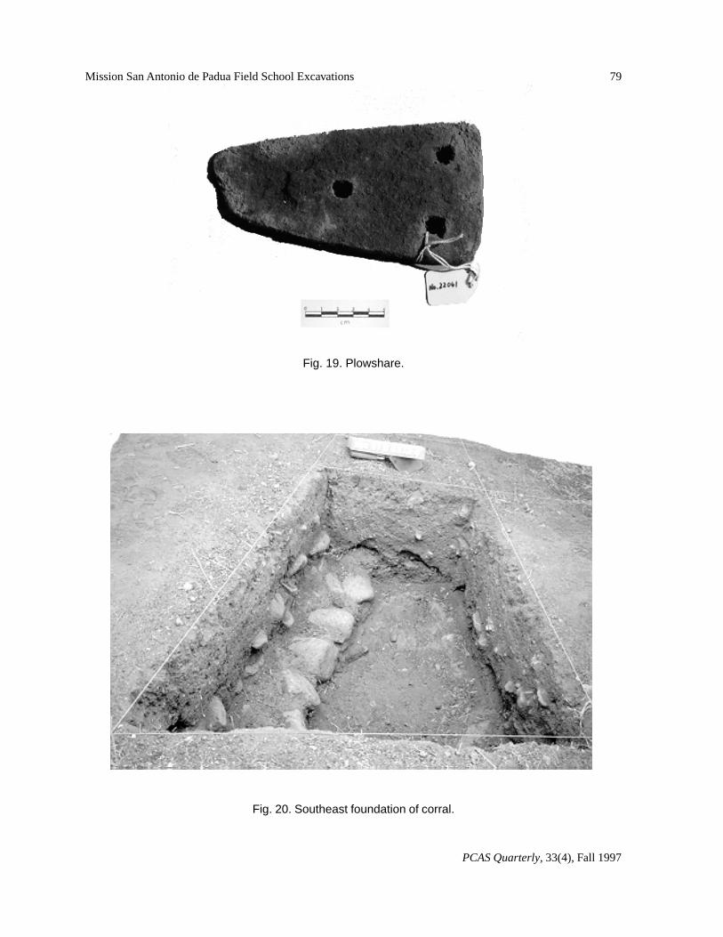
In order to retain the integrity of the original adobe wall, Crew 1 began another STP southof the southern wall. They were then able to extend northward until they found the foundationstones of the wall. The individual bricks of the adobe wall, however, were not discernible. Inthis area several small ash pits were found under the adobe melt, indicating there had been fireoutside the structure. A moderate quantity of charred and butchered bone fragments within theash indicated this deposit was probably the result of cooking fires. Since the fields werenearby and the adobe structures were some distance away, these fires could have been madeby those who wanted a noonday meal. The wall would offer shelter of a sort. An iron plow-share (Fig.19) and an iron ring were found in this area. Past excavations have indicated thatmost adobe walls were approximately one vara, or 33 inches, thick. To determine the thick-ness of the wall, Crew 1 began a new excavation inside the structure and moved south to findthe interior side of the wall. The hard pan floor was not evident in this area, and it was con-cluded that rodent activity most likely destroyed the evidence of the hard pan. In addition tothe foundation stones, there appeared an unusual feature at the base of the foundation of theinterior wall. A row of large cobbles extending 20 cm from the base of the foundation stoneswas found (Fig. 20).
Roof tiles, or tejas, were only found close to the adobe wall. This leads us to conclude thatthe walls were capped with tejas to protect the adobe structure. Because the span of the visibleruins exceeded 40 feet and the tejas were only found in close proximity to the walls, weconcluded the structure itself did not have a roof. The excavation found very few artifactswithin the interior of the ruin, and none of those found was felt to be of primary deposition.Artifacts that were found inside the enclosure were secondary depositions associated with theadobe melt. This lack of evidence indicates that this structure was not occupied by humans.The lack of a roof and tiled floor rules out the possibility of the structure being a granary. Thebest supposition is that this structure was an animal pen of some sort. Since the structure wasbuilt on a gradient, a sheep or goat corral would make sense as opposed to a cattle corral sinceonly a mountainous animal would feel comfortable on such a slope.
The articulation of the northwest corner of the structure and the exposure of part of thesouthern wall allowed the teams to extrapolate a projection of these walls with lines. Thesouthwest corner was estimated and agreed with the visible evidence. Measurements weretaken of the estimated interior of the structure and resulted in dimensions of 43.5 feet by 41feet. A review of building activities at the Mission indicated a corral for goats was built in1827 (Engelhardt 1972: 48). The dimensions given for this corral were 43 feet square. Thecorrelation of the dimensions of the excavated structure with the dimensions given for thegoat corral along with the lack of artifacts result in this being the best explanation for thestructure. In addition, the county of Monterey in 1850 identified the building just south of thegrist mill as a sheep pen (Appendix).
79
PCAS Quarterly, 33(4), Fall 1997
Mission San Antonio de Padua Field School Excavations
Fig. 19. Plowshare.
Fig. 20. Southeast foundation of corral.
80
PCAS Quarterly, 33(4), Fall 1997
Luther Bertrando
Discussion
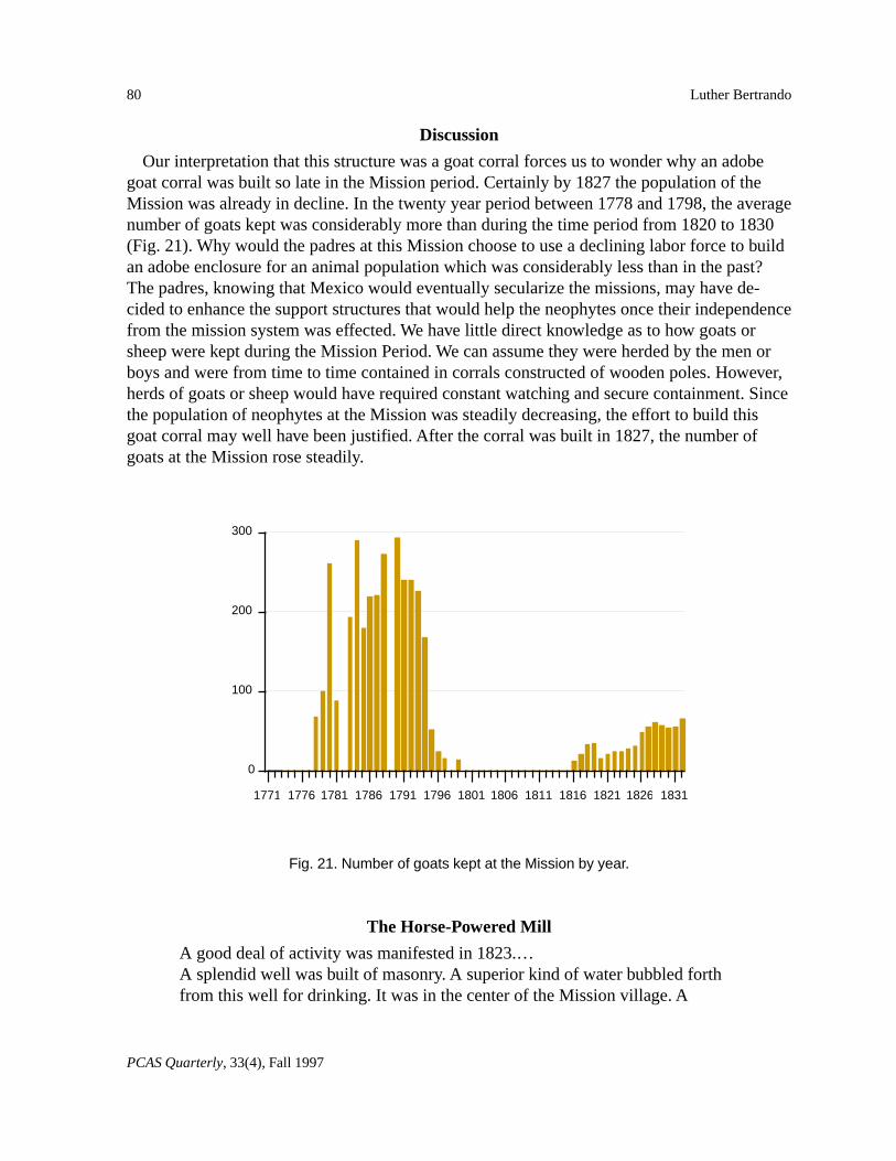
Our interpretation that this structure was a goat corral forces us to wonder why an adobegoat corral was built so late in the Mission period. Certainly by 1827 the population of theMission was already in decline. In the twenty year period between 1778 and 1798, the averagenumber of goats kept was considerably more than during the time period from 1820 to 1830(Fig. 21). Why would the padres at this Mission choose to use a declining labor force to buildan adobe enclosure for an animal population which was considerably less than in the past?The padres, knowing that Mexico would eventually secularize the missions, may have de-cided to enhance the support structures that would help the neophytes once their independencefrom the mission system was effected. We have little direct knowledge as to how goats orsheep were kept during the Mission Period. We can assume they were herded by the men orboys and were from time to time contained in corrals constructed of wooden poles. However,herds of goats or sheep would have required constant watching and secure containment. Sincethe population of neophytes at the Mission was steadily decreasing, the effort to build thisgoat corral may well have been justified. After the corral was built in 1827, the number ofgoats at the Mission rose steadily.
The Horse-Powered Mill
A good deal of activity was manifested in 1823.…A splendid well was built of masonry. A superior kind of water bubbled forthfrom this well for drinking. It was in the center of the Mission village. A
300
200
100
0
1771 1776 1781 1786 1791 1796 1801 1806 1811 1816 1821 1826 1831
Fig. 21. Number of goats kept at the Mission by year.
81
PCAS Quarterly, 33(4), Fall 1997
Mission San Antonio de Padua Field School Excavations
Horse-powered mill was also erected, and a room attached for other purposes.This building measured sixteen and three quarter varas by nine and threequarter varas, or about forty-seven by twenty-six feet. The walls were of adobeand roofed with tiles. (Engelhardt 1972:44)
As the second project of the 1996 season, Crews 1 and 2 began the process of determiningthe identity and use of an unknown ruin located to the north and east of the water-poweredgrist mill. The northwestern portion of the ruin had exposed stone foundations that delineatedthe northwest corner with great clarity. Crew 1 chose to explore the western portion of the ruinwhile Crew 2 explored the eastern portion, consisting of a large, deep depression.
The Western Portion
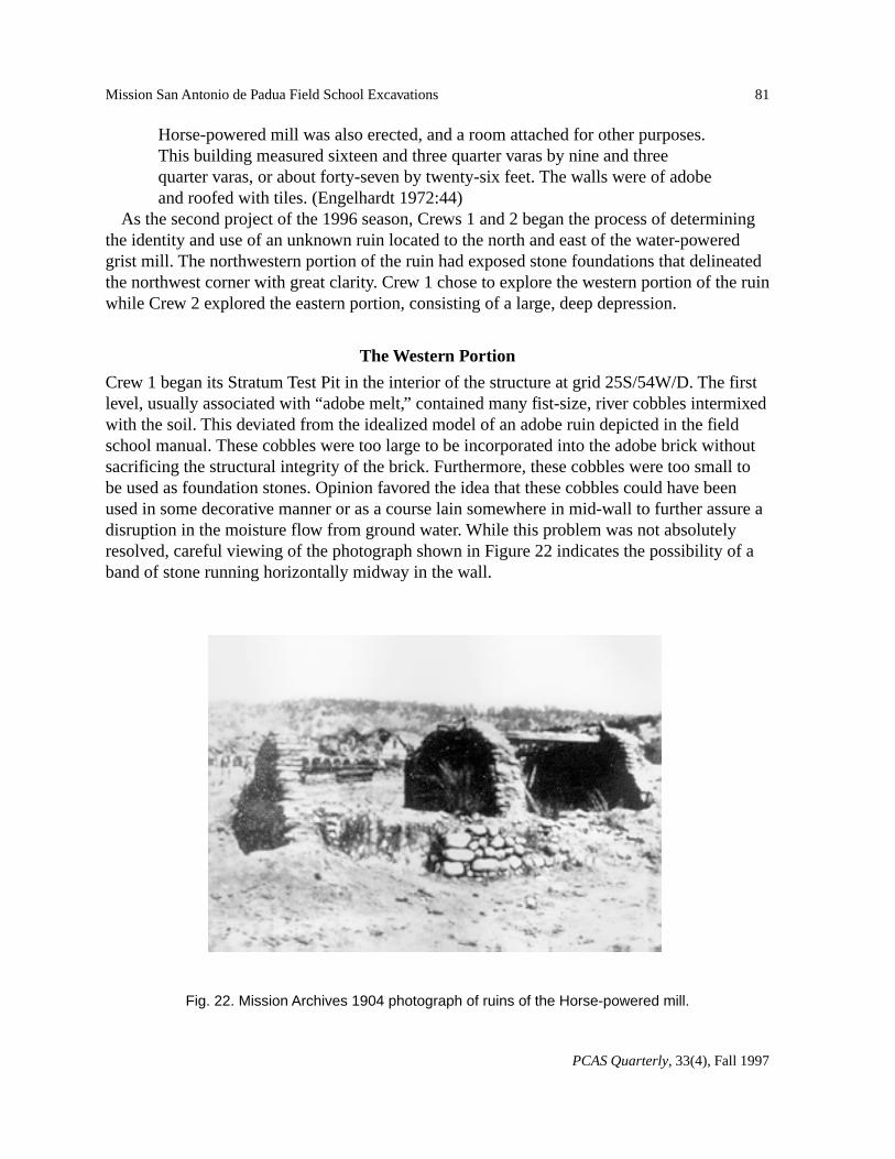
Crew 1 began its Stratum Test Pit in the interior of the structure at grid 25S/54W/D. The firstlevel, usually associated with “adobe melt,” contained many fist-size, river cobbles intermixedwith the soil. This deviated from the idealized model of an adobe ruin depicted in the fieldschool manual. These cobbles were too large to be incorporated into the adobe brick withoutsacrificing the structural integrity of the brick. Furthermore, these cobbles were too small tobe used as foundation stones. Opinion favored the idea that these cobbles could have beenused in some decorative manner or as a course lain somewhere in mid-wall to further assure adisruption in the moisture flow from ground water. While this problem was not absolutelyresolved, careful viewing of the photograph shown in Figure 22 indicates the possibility of aband of stone running horizontally midway in the wall.
Fig. 22. Mission Archives 1904 photograph of ruins of the Horse-powered mill.
82
PCAS Quarterly, 33(4), Fall 1997
Luther Bertrando
Below the Stratum I level was a very significant tile fall, most assuredly from the roof.Beneath this fall was an ashy lens with very distinct pockets of ash, indicating a fire of consid-erable fuel. As the stratum test pit was extended outward, the ash layer and heavier concentra-tion of ash continued indicating a structure fire throughout the width of the room. The floor ofthe structure was indicated only by the heavy ash concentrations; however, beneath this“floor” were found many large river cobbles not placed in any deliberate fashion. It appearsquite possible that this lower stratum is the natural result of the meandering of either the SanAntonio River or of the Mission Creek.
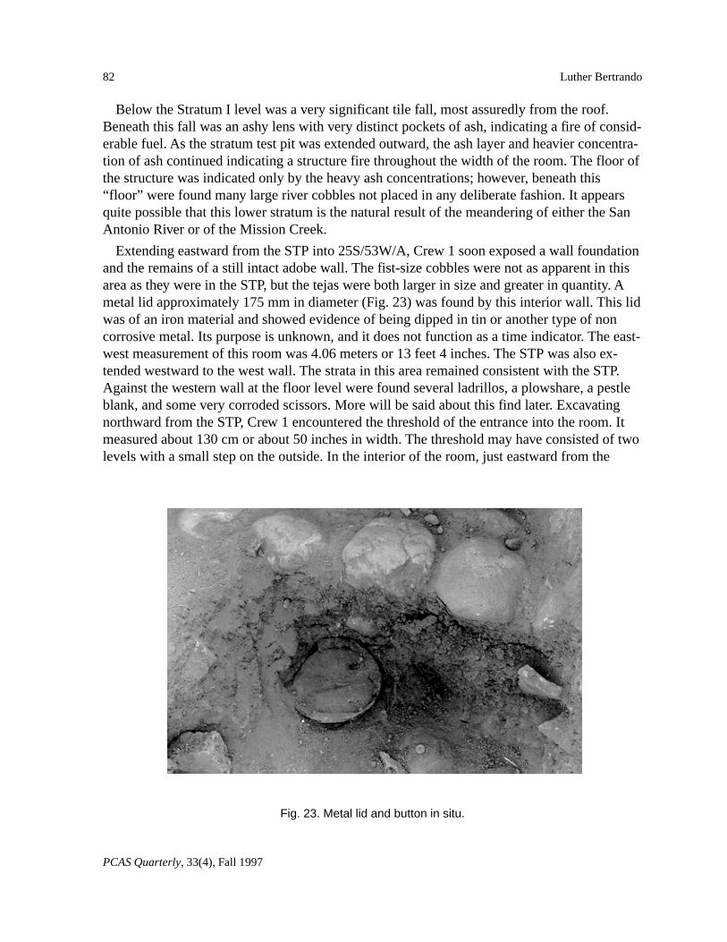
Extending eastward from the STP into 25S/53W/A, Crew 1 soon exposed a wall foundationand the remains of a still intact adobe wall. The fist-size cobbles were not as apparent in thisarea as they were in the STP, but the tejas were both larger in size and greater in quantity. Ametal lid approximately 175 mm in diameter (Fig. 23) was found by this interior wall. This lidwas of an iron material and showed evidence of being dipped in tin or another type of noncorrosive metal. Its purpose is unknown, and it does not function as a time indicator. The east-west measurement of this room was 4.06 meters or 13 feet 4 inches. The STP was also ex-tended westward to the west wall. The strata in this area remained consistent with the STP.Against the western wall at the floor level were found several ladrillos, a plowshare, a pestleblank, and some very corroded scissors. More will be said about this find later. Excavatingnorthward from the STP, Crew 1 encountered the threshold of the entrance into the room. Itmeasured about 130 cm or about 50 inches in width. The threshold may have consisted of twolevels with a small step on the outside. In the interior of the room, just eastward from the
Fig. 23. Metal lid and button in situ.
83
PCAS Quarterly, 33(4), Fall 1997
Mission San Antonio de Padua Field School Excavations
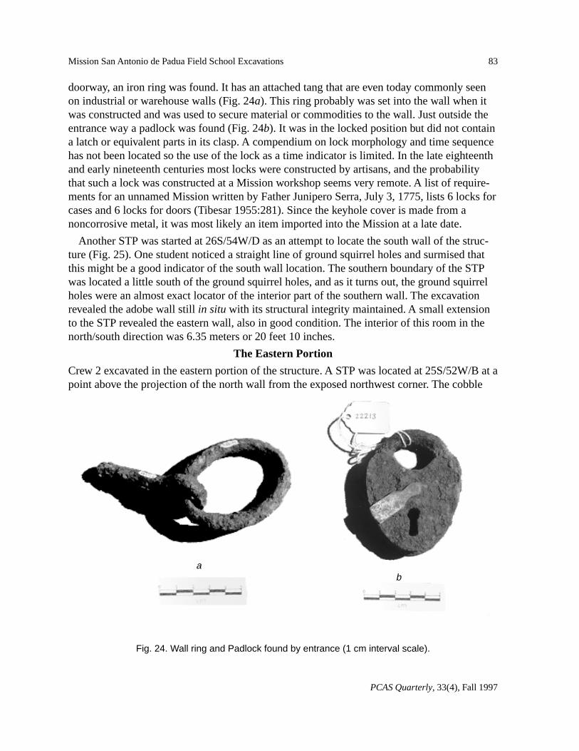
doorway, an iron ring was found. It has an attached tang that are even today commonly seenon industrial or warehouse walls (Fig. 24a). This ring probably was set into the wall when itwas constructed and was used to secure material or commodities to the wall. Just outside theentrance way a padlock was found (Fig. 24b). It was in the locked position but did not containa latch or equivalent parts in its clasp. A compendium on lock morphology and time sequencehas not been located so the use of the lock as a time indicator is limited. In the late eighteenthand early nineteenth centuries most locks were constructed by artisans, and the probabilitythat such a lock was constructed at a Mission workshop seems very remote. A list of require-ments for an unnamed Mission written by Father Junipero Serra, July 3, 1775, lists 6 locks forcases and 6 locks for doors (Tibesar 1955:281). Since the keyhole cover is made from anoncorrosive metal, it was most likely an item imported into the Mission at a late date.
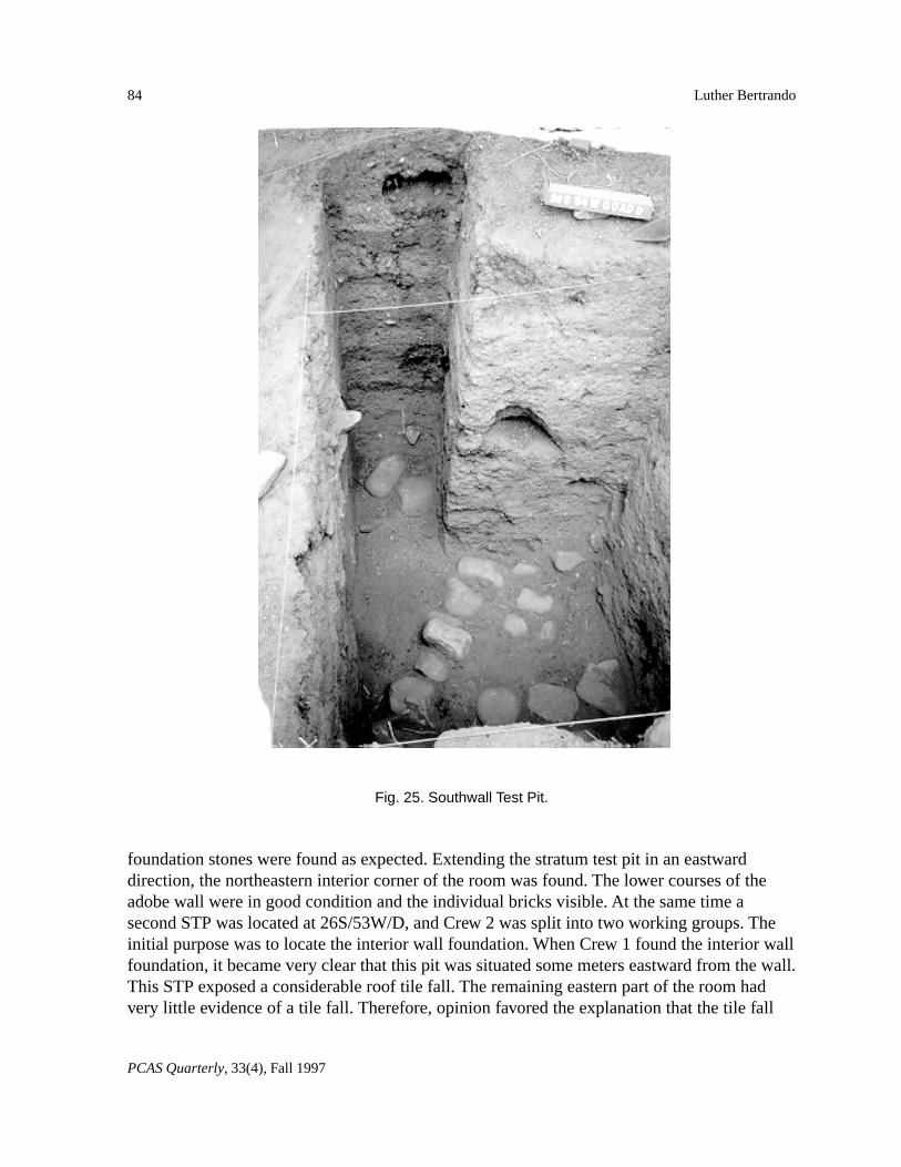
Another STP was started at 26S/54W/D as an attempt to locate the south wall of the struc-ture (Fig. 25). One student noticed a straight line of ground squirrel holes and surmised thatthis might be a good indicator of the south wall location. The southern boundary of the STPwas located a little south of the ground squirrel holes, and as it turns out, the ground squirrelholes were an almost exact locator of the interior part of the southern wall. The excavationrevealed the adobe wall still in situ with its structural integrity maintained. A small extensionto the STP revealed the eastern wall, also in good condition. The interior of this room in thenorth/south direction was 6.35 meters or 20 feet 10 inches.
The Eastern Portion
Crew 2 excavated in the eastern portion of the structure. A STP was located at 25S/52W/B at apoint above the projection of the north wall from the exposed northwest corner. The cobble
Fig. 24. Wall ring and Padlock found by entrance (1 cm interval scale).
ab
84
PCAS Quarterly, 33(4), Fall 1997
Luther Bertrando
foundation stones were found as expected. Extending the stratum test pit in an eastwarddirection, the northeastern interior corner of the room was found. The lower courses of theadobe wall were in good condition and the individual bricks visible. At the same time asecond STP was located at 26S/53W/D, and Crew 2 was split into two working groups. Theinitial purpose was to locate the interior wall foundation. When Crew 1 found the interior wallfoundation, it became very clear that this pit was situated some meters eastward from the wall.This STP exposed a considerable roof tile fall. The remaining eastern part of the room hadvery little evidence of a tile fall. Therefore, opinion favored the explanation that the tile fall
Fig. 25. Southwall Test Pit.
85
PCAS Quarterly, 33(4), Fall 1997
Mission San Antonio de Padua Field School Excavations
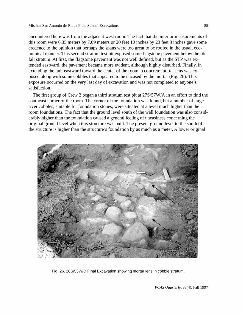
encountered here was from the adjacent west room. The fact that the interior measurements ofthis room were 6.35 meters by 7.09 meters or 20 feet 10 inches by 23 feet 3 inches gave somecredence to the opinion that perhaps the spans were too great to be roofed in the usual, eco-nomical manner. This second stratum test pit exposed some flagstone pavement below the tilefall stratum. At first, the flagstone pavement was not well defined, but as the STP was ex-tended eastward, the pavement became more evident, although highly disturbed. Finally, inextending the unit eastward toward the center of the room, a concrete mortar lens was ex-posed along with some cobbles that appeared to be encased by the mortar (Fig. 26). Thisexposure occurred on the very last day of excavation and was not completed to anyone’ssatisfaction.
The first group of Crew 2 began a third stratum test pit at 27S/57W/A in an effort to find thesoutheast corner of the room. The corner of the foundation was found, but a number of largeriver cobbles, suitable for foundation stones, were situated at a level much higher than theroom foundations. The fact that the ground level south of the wall foundation was also consid-erably higher than the foundation caused a general feeling of uneasiness concerning theoriginal ground level when this structure was built. The present ground level to the south ofthe structure is higher than the structure’s foundation by as much as a meter. A lower original
Fig. 26. 26S/53W/D Final Excavation showing mortar lens in cobble stratum.
86
PCAS Quarterly, 33(4), Fall 1997
Luther Bertrando
ground level also infers that the mill race has considerable foundation below what can now beseen.
Final Analysis
The exterior measurement of this structure is 14.38 by 8.23 meters. This translates into 47 feetby 27 feet and is very close to the 47 feet by 26 feet reported by Engelhardt as the measure-ments for the horse-powered mill. Why build a horse-powered mill when a water-poweredmill was already available in the same area? Any long-time resident of California wouldrespond that it was built because of the lack of a dependable, steady, water supply. To locatesuch a mill next to an existing water-powered mill seems to make common sense. In 1806 thewater-powered mill was constructed (Engelhardt 1972:27). A review of the history of buildingactivities at the Mission indicates that in 1810 a horse-powered mill was constructed for thegrinding of wheat (Engelhardt 1972:27). Why build another horse-powered mill in 1823?
The most likely answer to this question comes from several sources. In the document fromProbate Court #2 dated August, 1850, and provided to the Mission Archive by Edna Kimbro,the inventory indicates “Tan (tanning?) House 15 by 10 yards in bad repair” (Appendix). Thesize conforms with our structure and its position implied by its order listed in the documentagrees with our location. Another indication of the use of this horse-powered mill is thefollowing:
Oak bark, which was the chief tanning agent used in the mission tanneries, wasgathered by the Indians from far and near, carted or carried to the mission, andground or pulverized in the same mill that was used for crushing olives. Thismill consisted of a round stone about three feet in diameter and from eight totwelve inches thick, its edge being slanted to fit the bottom of the saucer orbowl-shaped well, or pit, in which it turned. The stone was affixed to an up-right pole which turned in bearings set in the center of the pit and in a horizon-tal beam above. This horizontal timber was supported by two upright posts,sometimes forked. The mill was usually turned by a blindfolded mule ordonkey harnessed to a sweep. Indians threw chunks of bark into the well of themill, diligently prodded the mule along the never ending path, removed thepulverized or crushed product, and repeated the performance until the requiredamount was ground (Webb 1952:192).
Since this horse-powered mill is also situated adjacent to the tanning vats, its most probableuse was as stated above. A space of at least 20 feet in diameter is required to contain a func-tional horse-powered mill, as confirmed by crew members who measured the existing 1950reconstruction on the Mission grounds. The interior measurements of the east room, 21 feet by24 feet, conform nicely to this requirement. The placement of the concrete mortar found in theroom is exactly in the center of the room. Only the lack of the mill pit and the mill stoneweaken our conclusion.
87
PCAS Quarterly, 33(4), Fall 1997
Mission San Antonio de Padua Field School Excavations
Building Deterioration
The photograph shown at the beginning of this paper is from the San Antonio Mission Ar-chives and is dated 1904, and while the roof is missing, at least one beam is still in place (Fig.22). The standing walls do not show signs of advanced erosion or “melting”, therefore theroof must have offered protection from the rain until around 1900. While in 1850 the buildingwas indicated as being in bad repair (Appendix), the exact nature of the bad repair was notspecified. Since the photograph shows no north or south walls in the ruins, the bad repaircould have referred to the collapse of these walls. When the Mission was nominated to theNational Register in 1934, the building was shown in the plans as a ruin configured similarlyto the ruin we find today. The structure of the ruin today clearly indicates that all the wallsbuilt in the north/south direction have toppled to the east. In addition, the walls built in theeast/west direction have toppled to the north. There is no evidence that these falls were con-current, and indeed, the photograph dated 1904 seems to indicate that these falls were notconcurrent. This toppling is also confirmed by the STP placed above the easternmost wall,where the individual bricks show they have “dominoed” to the east. The major earthquakethat struck San Francisco in 1906 would have occurred at a time to agree with this building’stime line, but many earthquakes must have struck this area between 1904 and 1934.
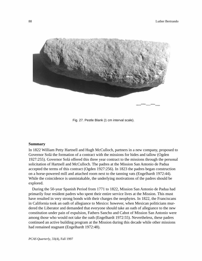
The roof fire in the western room also entombed artifacts at the time of the fire and partialroof collapse. Exactly when this fire occurred has not been determined. While the plowshareand pestle would have been common throughout the history of the Mission, the round lid withevidence of tinning, and perhaps the bone button, would have been present only very late inits history, most likely after secularization. The room and the surrounding area offered noevidence that it had ever been used as a living quarter to house the population that remained atthe Mission after secularization. Records indicate that in 1850 there were “57 indians of allages and sexes, several of whom are near one hundred years of age” (Appendix). The fire thatcaused part of the roof to collapse probably occurred sometime in the 1840s which wouldhave caused the building to be in bad repair in 1850. Therefore, of particular significance isthe find of several ladrillos, a plowshare, and a pestle blank in close proximity against thewestern wall of the room and in an arrangement that suggests a small work area. The plow-share, while similar to the one depicted in Figure 19, was considerably thicker and heavier.Even though battering was not visible, the plowshare might have been used as a hammer toshape the pestle. Natural corrosion could have masked evidence of battering on the plowshare.However, close inspection of both artifacts failed to find direct evidence of battering. Yet,since a pestle was being formed and shaped sometime in the 1840s (Fig. 27), one must appre-ciate the situation of the Indians still living at the Mission and their need to re-establish thetools of their cultural past in order to eke out a living from the land. It is difficult not tointerpret this feature in this way, as a kind of reverse acculturation. Unfortunately, our recov-ery techniques did not allow the detection of the debitage we would expect from such amanufacturing process.
88
PCAS Quarterly, 33(4), Fall 1997
Luther Bertrando
Summary
In 1822 William Petty Hartnell and Hugh McCulloch, partners in a new company, proposed toGovernor Solá the formation of a contract with the missions for hides and tallow (Ogden1927:255). Governor Solá offered this three year contract to the missions through the personalsolicitation of Hartnell and McCulloch. The padres at the Mission San Antonio de Paduaaccepted the terms of this contract (Ogden 1927:256). In 1823 the padres began constructionon a horse-powered mill and attached room next to the tanning vats (Engelhardt 1972:44).While the coincidence is unmistakable, the underlying motivations of the padres should beexplored.
During the 50-year Spanish Period from 1771 to 1822, Mission San Antonio de Padua hadprimarily four resident padres who spent their entire service lives at the Mission. This musthave resulted in very strong bonds with their charges the neophytes. In 1822, the Franciscansin California took an oath of allegiance to Mexico: however, when Mexican politicians mur-dered the Liberator and demanded that everyone should take an oath of allegiance to the newconstitution under pain of expulsion, Fathers Sancho and Cabot of Mission San Antonio wereamong those who would not take the oath (Engelhardt 1972:55). Nevertheless, these padrescontinued an active building program at the Mission during this decade while other missionshad remained stagnant (Engelhardt 1972:48).
Fig. 27. Pestle Blank (1 cm interval scale).
89
PCAS Quarterly, 33(4), Fall 1997
Mission San Antonio de Padua Field School Excavations
In this particular case, we find the padres planning and building a structure that wouldsupport and expand the tanning facilities at the Mission. Initially, Hartnell and McCullochshipped dry hides to England, many arriving in a wormed condition and sold at losses (Ogden1927:260). Even late into this trading cycle, green hides were preferred at the receiving endwhere tanning facilities and methods were thought to be better. McCulloch, Hartnell andCompany had great difficulty in instructing the Indians in their preferred manner of hidecuring, the Indians persistently ignoring verbal instructions and proceeding in their accus-tomed manner (Ogden 1927:261). It appears from these facts that the padres had hopes ofincreasing the price received from hides by providing the leather tanned. As it turned out, itwas not long before the California hide trade was considered unprofitable (Ogden 1927:260).
Whether the padres wanted to enrich the Mission, or to establish a trade that would benefitthe neophytes directly is an open question. Was this building an attempt to provide the Indiansof this Mission a place in the world of trade at this time? Were all the building activities inthis decade directed to providing the Indian with their impending independence? While it ispresumptuous to extend the scope of archaeology into exploring motive, using archaeology tofocus our attention on the particulars of history that are often omitted in general overviewsseems a legitimate use of archaeology. While the building of the missions was well docu-mented due to the administrative codes of the Spanish Empire, the documentation of thedecline of the missions is lacking. In exploring the missions archaeologically, the majority ofthe evidence retrieved will be from this later period in their history. It is therefore imperativethat supporting documentation, whether written or verbal, be acquired and archived to assistcontinuing archaeological investigations and give the investigations the breadth that goodinterpretation requires.
Acknowledgments
Crew 3 from 1993: Barbara Bergeron, Ken Butler, Cheryl Forshee, Kevin Crocker, SusannaNicoletto, Richard Swedberg who did a professional job of excavating and interpreting. Crew4 from 1993: Andrea Bier, Yvonne Fisher, Jessica Freedman, Pamela Lewiston, and DavidSchwartz who had to overcome many difficulties. Crew 3 from 1994: Crystal Griffiths,Rachael Hensley, Bryce Jackson, Susan Kearney, Lisa Ortega, and Arend Thorp who laboredindependently. Crew 4 from 1994: Johanna Bettis, Georganna Hawley, Scott Martin, LonnaSiebert who answered the open questions. Crews 1 and 2 from 1996: Francesca Bosco, KarenBrey, Charlotte Brown, Scott Chattin, Bianca Cook, Joy de Korte, Ryan Felsing, Joey Gill,Isabel Jenkins, Jaye Lappin, David Lindsay, Aurelia Smith, Garret Tippin, and Tom Wilsonwho excavated the Goat Corral and directed and excavated the Horse-powered Mill. I wish Icould include in these reports the entire scope of your interpretations and insights.
90
PCAS Quarterly, 33(4), Fall 1997
Luther Bertrando
References Cited
Beilharz, Edwin A.1971 Felipe de Neve, First Governor of California. California Historical Society, San Fran-
cisco.
Bonilla, Antonio Isaac1974 Garcia Hechos and Other Garcia Papers. Reproduced by permission of the Director,
Bancroft Library, University of California, Berkeley.
Costello, Julia Garvin1990 Variability and Economic Change in the California Missions: An Historical and Ar-
chaeological Study. A Dissertation submitted for Doctor of Philosophy, University ofCalifornia, Santa Barbara.
1994 The Ranches and Ranchos of Mission San Antonio de Padua. California MissionStudies Association, Keepsake Volume, December 1994.
Engelhardt, Zephyrin1972 Mission San Antonio de Padua. Ballena Press, Ramona, California.
Glenn, Brian1991 Typological Analysis of Projectile Points Recovered from Excavations on Vandenberg
Air Force Base, Santa Barbara County, California. A Master’s Paper submitted inpartial satisfaction of the requirements for the masters degree in archaeology, Univer-sity of California, Los Angeles.
Greenwood, Roberta S.1972 9000 Years of Prehistory at Diablo Canyon, San Luis Obispo County, California. San
Luis Obispo County Archaeological Society Occasional Papers 2. San Luis Obispo,California.
Hoover, Robert L., and Julia G. Costello1985 Excavations at Mission San Antonio 1976-1978. Monograph XXVI Institute of Ar-
chaeology, University of California, Los Angeles.
Miller, Henry1952 Account of a Tour of the California Missions, 1856, the Journal and Drawings of
Henry Miller. Grabhorn Press, San Francisco.
91
PCAS Quarterly, 33(4), Fall 1997
Mission San Antonio de Padua Field School Excavations
Ogden, Adele1927 Hides and Tallow McCulloch, Hartnell and Company 1822-1828. California Histori-
cal Society Quarterly Volume VI. California Historical Society, San Francisco.
Peacock, Primrose1972 Antique Buttons. Drake Publishers Inc., New York.
Sawyer, William B.1985 Excavation Procedures in Excavation at Mission San Antonio 1976-1978 Edited by
Robert L. Hoover and Julia G. Costello, Monograph XXVI Institute of Archaeology,University of California, Los Angeles.
Sloane, Eric1973 A Museum of Early American Tools. Ballatine Books, New York.
Tibesar, Antonine1955 Writings of Junipero Serra, Volume I. Academy of American Franciscan History,
Washington, D. C.
Toulouse, Julian Harrison1971 Bottle Makers and their Marks. Thomas Nelson & Sons Limited., Camden, New
Jersey.
Webb, Edith Buckland1952 Indian Life at the Old Missions. University of Nebraska Press: Lincoln and London.
92
PCAS Quarterly, 33(4), Fall 1997
Luther Bertrando
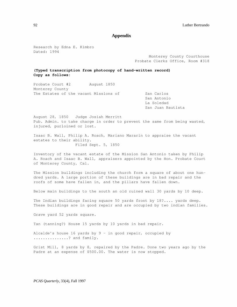
Appendix
Research by Edna E. KimbroDated: 1994
Monterey County CourthouseProbate Clerks Office, Room #318
(Typed transcription from photocopy of hand-written record)Copy as follows:
Probate Court #2 August 1850Monterey CountyThe Estates of the vacant Missions of San Carlos
San AntonioLa SoledadSan Juan Bautista
August 28, 1850 Judge Josiah MerrittPub. Admin. to take charge in order to prevent the same from being wasted,injured, purloined or lost.
Isaac B. Wall, Philip A. Roach, Mariano Mararin to appraise the vacantestates to their ability.
Filed Sept. 5, 1850
Inventory of the vacant estate of the Mission San Antonio taken by PhilipA. Roach and Isaac B. Wall, appraisers appointed by the Hon. Probate Courtof Monterey County, Cal.
The Mission buildings including the church form a square of about one hun-dred yards. A large portion of these buildings are in bad repair and theroofs of some have fallen in, and the pillars have fallen down.
Below main buildings to the south an old ruined wall 30 yards by 10 deep.
The Indian buildings facing square 50 yards front by 18?.... yards deep.These buildings are in good repair and are occupied by two indian families.
Grave yard 52 yards square.
Tan (tanning?) House 15 yards by 10 yards in bad repair.
Alcalde’s house 16 yards by 9 - in good repair, occupied by...............? and family.
Grist Mill, 8 yards by 8, repaired by the Padre. Done two years ago by thePadre at an expense of $500.00. The water is now stopped.
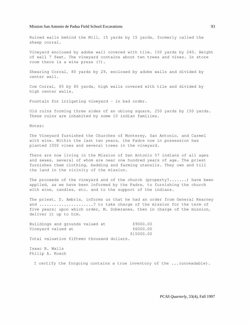
93
PCAS Quarterly, 33(4), Fall 1997
Mission San Antonio de Padua Field School Excavations
Ruined walls behind the Mill, 15 yards by 15 yards, formerly called thesheep corral.
Vineyard enclosed by adobe wall covered with tile. 150 yards by 240. Heightof wall 7 feet. The vineyard contains about ten trees and vines. In storeroom there is a wine press (?).
Shearing Corral, 80 yards by 29, enclosed by adobe walls and divided bycenter wall.
Cow Corral, 85 by 80 yards, high walls covered with tile and divided byhigh center walls.
Fountain for irrigating vineyard - in bad order.
Old ruins forming three sides of an oblong square, 250 yards by 150 yards.These ruins are inhabited by some 10 indian families.
Notes:
The Vineyard furnished the Churches of Monterey, San Antonio, and Carmelwith wine. Within the last two years, the Padre now in possession hasplanted 1000 vines and several trees in the vineyard.
There are now living in the Mission of San Antonio 57 indians of all agesand sexes, several of whom are near one hundred years of age. The priestfurnishes them clothing, bedding and farming utensils. They own and tillthe land in the vicinity of the mission.
The proceeds of the vineyard and of the church (property?.......) have beenapplied, as we have been informed by the Padre, to furnishing the churchwith wine, candles, etc. and to the support of the indians.
The priest, D. Ambris, informs us that he had an order from General Kearneyand ......................? to take charge of the mission for the term offive years; upon which order, M. Soberanes, then in charge of the mission,deliver it up to him.
Buildings and grounds valued at $9000.00Vineyard valued at $6000.00
$15000.00Total valuation fifteen thousand dollars.
Isaac B. WallsPhilip A. Roach
I certify the forgoing contains a true inventory of the ...(unreadable).


![[San Antonio de Padua Parish] PASKO SA SAN ANTONIO 2015](https://img.pdfslide.us/doc/110x75/5790728c1a28ab6874a75278/san-antonio-de-padua-parish-pasko-sa-san-antonio-2015.jpg)