Embed Size (px)
Citation preview

MINUTES OF THE MEETING
OF THE
CITY PLAN COMMISSION
TUESDAY, April 21, 2015
The City Plan Commission held its regular meeting on Tuesday, April 21, 2015 in the Council
Chambers on the 26th
Floor of City Hall. The following members were:
PRESENT
Ms. Babette Macy Chairwoman (Arrived at Noon)
Rev. Stan Archie Vice Chair (Left at Noon)
Mr. Enrique Gutierrez Member
Ms. Margaret J. May Member
Ms. Bobbi Baker-Hughes Member
Mr. Coby Crowl Member
Ms. Trish Martin Member
ABSENT
None
ALSO PRESENT
Ms. Diane Binckley Assistant Secretary
Mr. John Eckardt Staff
Mr. Olofu Agbaji Staff
Ms. Ashley Winchell Staff
Ms. Patty Noll Staff
Ms. Marty Campbell Recording Secretary
Ms. Maggie Moran Legal Counsel
Mr. Wei Sun Public Works
Mr. Brett Cox Land Development
Vice Chair Archie called the meeting to order at 9:15 A.M.

MINUTES OF THE MEETING OF TUESDAY THE CITY PLAN COMMISSION 2 April 21, 2015
RE: Case No. 11924-P-15
APPLICANT: Melani Samora
Casey’s Marketing Company
One Convenience Boulevard
Ankeny, IA 50021
PROPERTY OWNER: WB Seventeen, LLC
9601 N Platte Purchase Drive
Kansas City, MO 64155
CONTACT: Jeff Laubach
Phelps Engineering
1270 Winchester Rd
Olathe, KS 66061
LOCATION: generally located at the southeast corner of Shoal Creek Parkway
and N Oak Trafficway
REQUESTS: to consider approval of a Chapter 80 final plan to allow for the
construction of a convenience store, canopy and sixteen gas
pumps.
Ms. Diane Binckley, Assistant Secretary entered the staff report into the record and stated that
the applicant had signed the consent agenda and agreed to all the conditions in the staff report.
Vice Chair Archie opened discussion to the public.
No one appeared in opposition.
Commissioner Crowl moved and Commissioner Martin seconded the motion to APPROVE
Case No. 11924-P-15 SUBJECT TO THE FOLLOWING CONDITIONS:
1. That five (5) collated, stapled and folded copies (and a CD containing a pdf file, a
georeferenced monochromatic TIF file, and CAD/GIS compatible layer of the site plan
boundary referenced to the Missouri state plan coordinate system) of (a revised drawing /all
listed sheets), revised as noted, be approved by the Development Management staff (15th
Floor, City Hall) prior to issuance of building permit showing:
Plan corrections a-f per City Planning & Development, Development Management Division
(Ashley Winchell, [email protected])

MINUTES OF THE MEETING OF TUESDAY THE CITY PLAN COMMISSION 3 April 21, 2015
a. A signage plan that meets the requirement of Chapter 88-445 in its entirety.
a. Indicate on the signage plan that no electronic/ digital sign will be installed on site.
b. Locations, dimensions and specifications of short- and long-term bicycle parking.
c. A landscaping plan that meets the requirements of Chapter 88-425 in its entirety.
d. Hours of operation on face of plan.
e. A window added to the north elevation of the structure.
f.
Landscaping including trees and shrubs added to the east side of the lot.
Motion carried 5-0
VOTING AYE: Archie, Baker-Hughes, Crowl, Gutierrez, May
VOTING NAY: None
ABSENT: Macy
RE: SD 1415 B, Final Plat, Kansas City Power and Light Southeast
Campus
APPLICANT/ OWNER: Joseph G. Jacobs
Kansas City Power & Light Co.
1200 Main St, 20th
Floor
Kansas City, MO 64105
AGENT: Keith Beatty
Kaw Valley Engineering
1104 E. 12th
Street
Emporia, KS 66801
LOCATION: Generally located at the northwest corner of I-470 and Raytown
Road.
AREA: Approximately 83 acres.
REQUESTS: To consider approval of a final plat in District B3-5 (Community
Business - dash 5), creating one (1) commercial lot.
Commissioner Crowl recused.
Ms. Diane Binckley, Assistant Secretary entered the staff report into the record and stated that
the applicant had signed the consent agenda and agreed to all the conditions in the staff report.
Vice Chair Archie opened discussion to the public.
No one appeared in opposition.
MINUTES OF THE MEETING OF TUESDAY THE CITY PLAN COMMISSION 4 April 21, 2015
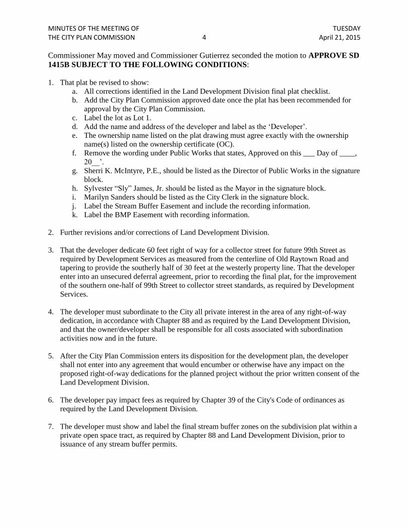
Commissioner May moved and Commissioner Gutierrez seconded the motion to APPROVE SD
1415B SUBJECT TO THE FOLLOWING CONDITIONS:
1. That plat be revised to show:
a. All corrections identified in the Land Development Division final plat checklist.
b. Add the City Plan Commission approved date once the plat has been recommended for
approval by the City Plan Commission.
c. Label the lot as Lot 1.
d. Add the name and address of the developer and label as the ‘Developer’.
e. The ownership name listed on the plat drawing must agree exactly with the ownership
name(s) listed on the ownership certificate (OC).
f. Remove the wording under Public Works that states, Approved on this ___ Day of ____,
20__’.
g. Sherri K. McIntyre, P.E., should be listed as the Director of Public Works in the signature
block.
h. Sylvester “Sly” James, Jr. should be listed as the Mayor in the signature block.
i. Marilyn Sanders should be listed as the City Clerk in the signature block.
j. Label the Stream Buffer Easement and include the recording information.
k. Label the BMP Easement with recording information.
2. Further revisions and/or corrections of Land Development Division.
3. That the developer dedicate 60 feet right of way for a collector street for future 99th Street as
required by Development Services as measured from the centerline of Old Raytown Road and
tapering to provide the southerly half of 30 feet at the westerly property line. That the developer
enter into an unsecured deferral agreement, prior to recording the final plat, for the improvement
of the southern one-half of 99th Street to collector street standards, as required by Development
Services.
4. The developer must subordinate to the City all private interest in the area of any right-of-way
dedication, in accordance with Chapter 88 and as required by the Land Development Division,
and that the owner/developer shall be responsible for all costs associated with subordination
activities now and in the future.
5. After the City Plan Commission enters its disposition for the development plan, the developer
shall not enter into any agreement that would encumber or otherwise have any impact on the
proposed right-of-way dedications for the planned project without the prior written consent of the
Land Development Division.
6. The developer pay impact fees as required by Chapter 39 of the City's Code of ordinances as
required by the Land Development Division.
7. The developer must show and label the final stream buffer zones on the subdivision plat within a
private open space tract, as required by Chapter 88 and Land Development Division, prior to
issuance of any stream buffer permits.
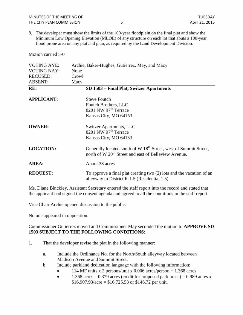
MINUTES OF THE MEETING OF TUESDAY THE CITY PLAN COMMISSION 5 April 21, 2015 8. The developer must show the limits of the 100-year floodplain on the final plat and show the
Minimum Low Opening Elevation (MLOE) of any structure on each lot that abuts a 100-year
flood prone area on any plat and plan, as required by the Land Development Division.
Motion carried 5-0
VOTING AYE: Archie, Baker-Hughes, Gutierrez, May, and Macy
VOTING NAY: None
RECUSED: Crowl
ABSENT: Macy
RE: SD 1503 – Final Plat, Switzer Apartments
APPLICANT: Steve Foutch
Foutch Brothers, LLC
8201 NW 97th
Terrace
Kansas City, MO 64153
OWNER: Switzer Apartments, LLC
8201 NW 97th
Terrace
Kansas City, MO 64153
LOCATION: Generally located south of W 18th
Street, west of Summit Street,
north of W 20th
Street and east of Belleview Avenue.
AREA: About 38 acres
REQUEST: To approve a final plat creating two (2) lots and the vacation of an
alleyway in District R-1.5 (Residential 1.5)
Ms. Diane Binckley, Assistant Secretary entered the staff report into the record and stated that
the applicant had signed the consent agenda and agreed to all the conditions in the staff report.
Vice Chair Archie opened discussion to the public.
No one appeared in opposition.
Commissioner Gutierrez moved and Commissioner May seconded the motion to APPROVE SD
1503 SUBJECT TO THE FOLLOWING CONDITIONS:
1. That the developer revise the plat in the following manner:
a. Include the Ordinance No. for the North/South alleyway located between
Madison Avenue and Summit Street.
b. Include parkland dedication language with the following information:
114 MF units x 2 persons/unit x 0.006 acres/person = 1.368 acres
1.368 acres – 0.379 acres (credit for proposed park areas) = 0.989 acres x
$16,907.93/acre = $16,725.53 or $146.72 per unit.

MINUTES OF THE MEETING OF TUESDAY THE CITY PLAN COMMISSION 6 April 21, 2015
c. Further recommendations and/or corrections of Land Development.
d. That the plat to include a 15 foot radius on all right of way corners.
e. Change 18th
Street to E 18th
Street and 20th
Street to E 20th
Street.
2. A storm drainage study will be required with the Building permit submittal.
3. A maintenance agreement will be required for the retaining wall along Summit St for the
portion of wall retaining the Right-of-Way.
4. An assessment of curb & gutter, sidewalk, and drive approaches along the perimeter will
be required with the Building submittal. A permit will be required to fix all items in
disrepair.
Motion carried 6-0
VOTING AYE: Archie, Baker-Hughes, Crowl, Gutierrez, Martin, May
VOTING NAY: None
ABSENT: Macy
RE: Case No. 636-S-3 –Amended and Restated Armour/Gillham
Corridor General Development Plan – Blight Study
Addendum
APPLICANT: Al Figuly; Planned Industrial Expansion Authority
REQUEST: About 55 acres on either side of West and East Armour Boulevard
from just east of Broadway Boulevard on the west to The Paseo on
the east, to consider the approval of an addendum to the Amended
and Restated Armour/Gillham Corridor Blight Study for the
Armour/Gillham Corridor General Development Plan,
pursuant to the Missouri Planned Industrial Expansion Authority
(PIEA) Law 100.300-100.620.
Ms. Diane Binckley, Assistant Secretary entered the staff report into the record requested this
matter be dismissed.
Vice Chair Archie opened discussion to the public.
No one appeared in opposition.
Commissioner Crowl moved and Commissioner Martin seconded the motion to DISMISS Case
No. 636-S-3.
Motion carried 6-0
VOTING AYE: Archie, Baker-Hughes, Crowl, Gutierrez, Martin, and May

MINUTES OF THE MEETING OF TUESDAY THE CITY PLAN COMMISSION 7 April 21, 2015
VOTING NAY: None
ABSENT: Macy
RE: Case No. 718-S
APPLICANT: Al Figuly, Executive Director
Planned Industrial Expansion Authority
20 E 5th
Street, Suite 200
Kansas City, Missouri 64106
LOCATION: Generally located on either side of N Corrington Avenue, north of
E Front Street
AREA: About 60 acres
REQUEST: To consider the approval of the Frontage at Executive Park Area
General Development Plan pursuant to the Missouri Planned
Industrial Expansion Authority (PIEA) Law 100.300-100.620,
RSMo.
Mr. John Eckardt, Staff Planner, presented the staff report and recommended approval subject to
the conditions in the staff report.
Vice Chair Archie asked to hear from the applicant.
Mr. Pat Sterritt, on behalf of the Planned Expansion Authority; he explained the parcel
components, the owner was Universal Land Development Company; he explained what an
“Undeveloped Industrial Area”; with conditions that retard economic or social growth and what
would be considered “qualifying conditions”.
He explained the cost factors, i.e. inactive or ineffective street layout; access roads on site were
trampled down vegetation/weeds; and the location of the electric transmission lines.
The economic waste was present by the lack of development and the low assessed values and tax
revenues; social liability was criminal trespass and illegal dumping.
They were proposing office, industrial and warehouse uses in excess of 850,000 sq. ft.; the
general development plan would be completed in 15 years.
There were no blighting factors; it simply qualified as an underdeveloped industrial area under
the PIA; and it had been determined that it was a project that was need of public assistance so
they asked their recommendation of approval of the General Development Plan as well as the
finding of an underdeveloped industrial area.
Vice Chair Archie asked about the law; what would be different about that property in order to
make it not to qualify.

MINUTES OF THE MEETING OF TUESDAY THE CITY PLAN COMMISSION 8 April 21, 2015
Mr. Sterritt answered anyone of those factors; if it didn’t satisfy any of those other factors, then it
certainly wouldn’t qualify.
Vice Chair Archie stated then by reason of inadequate street layout, physical improvements,
inadequate subdivision, platting of vacant lots of the land not being used economically and it
contained elements that it had been there for a long time. If he would make a difference between
whether or not it was or was not, then he would have to note what did it quality.
Mr. Sterritt answered that one of the items as a result of the conditions that is there social
liability; without the criminal trespass on the site, then there would be some question on whether
or not the site would qualify as an underdeveloped industrial area. That element did have to be
there.
Commissioner May stated he had mentioned it was a growing industrial area; had there been
anything given by PIA for any of the part that had grown.
Mr. Sterritt answered yes.
Commissioner May asked about the property he was currently there on; was it tax delinquent.
Mr. Sterrit answered yes.
Commissioner May stated those were the things that caused her problems; currently being
delinquent in taxes and then looking for tax abatements to stimulate growth. When did they stop
giving tax abatements to areas that were growing?
Mr. Sterritt stated that the Executive Park had been there since 1974; while there were certain
things in industrial areas that received public assistance, there hadn’t been growth on that side of
the Avenue.
Commissioner Baker-Hughes asked so they weren’t finding blight but inadequacy? How did the
thing that Mr. Eckardt mentioned would not apply nor would they change the wording from
blight to inadequacy.
Mr. Aaron Marsh, attorney with White Goss Law firm, representing the frontage at Executive
Park; they hoped to develop 3 state-of-the-art industrial warehouse buildings in an area in the
east bottoms that was a mature market. There had not been a new state-of-the-art over 100,000
sq. ft. warehouses built in that area. In order for them to compete in the market, they would like
to develop those buildings and invest over 52 million dollars in all 3 buildings.
A little history, the Missouri Constitution as a standalone matter allowed for the grant of tax
abatement to promote industrial development. The PIA statute stated that if the land that was
underdeveloped industrial area, that body itself with a couple of other criteria allowed the grant
of tax abatement. The Plan that they were asking for them to endorse was approved by the PIA
Board they all said that was an area of the City where it was actually an underdeveloped
industrial area and there happened to be some of those criteria; there were no streets that went to
MINUTES OF THE MEETING OF TUESDAY THE CITY PLAN COMMISSION 9 April 21, 2015
the 60-acre tract; there was an old temporary cul de sac that was the south border that was
crumbling; there was vagrancy, illegal dumping, so there were some of those criteria in addition
to an underutilized underdeveloped industrial area. They were asking them to endorse the plan
which didn’t provide for a specific amount of tax abatement; should the Plan be approved by the
City Council, on a project by project basis they had to go back before the PIA Board and make
their case for the level of incentives for each individual building.
Vice Chair Archie asked if he agreed that as they looked at it and agreed to a finding there ought
to be a means of comparing contracts; they should be able to say that was isolated from all of the
other like properties and get the designation from something that was clearly defined in their
minds.
Mr. Marsh stated yes, he believed they did qualify; they were not just a bean field; they were
something more in the middle of an industrial area; they didn’t have roads, they had illegal
dumping, vagrancy and those characteristics alone were enough for the to satisfy the PIA statute.
Vice Chair Archie stated that then no roads and illegal dumping meant that industrial area
qualified for a category that gave tax abatements up to 25 years.
Mr. Marsh stated it qualified according to the PIA statute.
Commissioner Baker-Hughes asked about the property to the east would also qualify.
Mr. Marsh answered that the property to the east where the City had its tow lot.
Commissioner Baker-Hughes assuming that it was owned by the same people they were talking
about; there were no roads; she was confused; she was struggling with it; she pointed out another
property and asked if that would qualify as inadequate.
Mr. Marsh answered he didn’t know the characteristics of that property.
Commissioner Baker-Hughes stated but she saw no roads.
Mr. Marsh stated that the fact there were no roads, inadequate street layout was a criteria; it may
not be sufficient criteria but it was criteria enough under the statute for a PIA Plan to be
approved using the classification of undeveloped industrial area. In their case, they had more
than that, dumping, people driving over the property, they didn’t have sewers, water extension;
they had a piece of property that had been passed over for industrial development for as long as
the east bottoms had been attractive industrial area. It was an opportunity to bring in an
industrial space that the industrial market was saying they had to have like 30 foot floor to
ceiling clearances; large spaces; they were not there asking for a specific amount of tax
abatement, they were asking to let them move forward in the process and continue to make their
case to the City Council and then to the PIA for specific tax abatement and that would be good
for the City of Kansas City.
MINUTES OF THE MEETING OF TUESDAY THE CITY PLAN COMMISSION 10 April 21, 2015
Vice Chair Archie stated there was a threshold they were looking for; and while the other things
were put very eloquently and they make sense, it didn’t make that threshold appear; like
defective and inadequate street road layouts and they were saying there were no roads; what he
meant was in any industrial property where there was no road then that meant it would be
defective and inadequate street layout.
Mr. Marsh stated that was correct; but he was saying they had more than just lack of streets; they
had property that was economically under-utilized which was an additional criterion.
Vice Chair Archie stated he had interpreted the law to him but he was reading it differently; and
the more he read it the greater his concerns.
Commissioner Crowl stated he could see the economic portion of it since the site wasn’t being
used; but there was a road; he was having trouble with the blight piece.
Commissioner May added on page 5 was where the wording needed to be changed from “blight”
“to underdeveloped industrial area due to inadequacy”; and what would be the next step.
Mr. Eckardt stated on page 6 (e) to change the wording; what he thought depending on what they
did they had to act on whether it was underdeveloped industrial area due to inadequacy and then
act on the approval of the plan; and then it would go forward to the City Council either way and
then he would tell the City Council what they had said. If the Council would approve it and in
order for them to seek tax abatement, they would have to come back to the Commission for a
rezoning to a UR; where they would address, again, those inadequacies.
Vice Chair Archie opened up the discussion to the audience.
Ms. Rhianna Disoledge, 14001 Lookout Drive, Kansas City, Missouri; came about another case,
but she would like to make a couple of comments. It was very non-specific, not sure whether it
was 5, 10, 15, or 25 years; didn’t understand the tax payer, the school districts, the library
systems that would all be affected by this tax abatement should be involved in something like
this. They heard the word “Kansas”; the distinct threat again that if they didn’t allow the tax
abatement, the business would run over to Kansas; she didn’t understand the state statute that
pertained to every undeveloped industrial area with no roads and no sewers and she was
speaking from a tax payer’s perspective and a neighborhood perspective. It was a bean field,
why did the developer choose that particular land without the infrastructure, without the roads,
sewers there was plenty of vacant land all over Kansas City. She would encourage them not to
vote for it and ask for more specifics on how long the tax abatement was going to go.
Mr. David (last name inaudible), Executive Director of PIA; the property that had the issues that
Mr. Marsh stated put the property at a significant disadvantage compared to its competitors; the
difference between those were the factors mentioned in keeping it from being developed.
DISCUSSION:

MINUTES OF THE MEETING OF TUESDAY THE CITY PLAN COMMISSION 11 April 21, 2015
Commissioner May stated she was having trouble with the tax abatement in that it seemed like it
had been used very liberal in certain areas and yet in parts of the City that she believed needed it
the most that was really keeping the City from moving forward because of cost, they were
limited; the whole thing of underdeveloped industrial area was a bit troublesome; when she
looked at that area in general, it didn’t appear that the larger area was underdeveloped, just that
portion that was outlined; whatever they did, moving on to Council; she felt it should not be
approved at their level and let the Council do whatever they think was appropriate.
Commissioner Crowl stated he found it difficult to call it blight; but inadequate he saw potential
with that because there would need to be a lot of improvements to be made to make the site
useable for future industrial use. He didn’t know if it was any more unique than any other open
sites around the City.
MOTION TO APPROVE THE FINDING OF AN UNDERDEVELOPED INDUSTRIAL
AREA; Motion failed 3-3; Voting Aye: Gutierrez, Martin and Crowl; Voting Nay: Archie, May,
and Baker-Hughes; Absent: Macy.
MOTION TO DENYTHE FINDING OF AN UNDERDEVELOPED INDUSTRIAL
AREA; Motion failed 3-3; Voting Aye: Archie, May, and Baker-Hughes; Voting Nay:
Gutierrez, Martin and Crowl; Absent: Macy.
Motion for RECOMMENDATION from City Plan Commission to City Council failed.
Motion to APPROVE the Executive Park Area General Development Plan with revisions to the
plan; Motion carried 4-2; Voting Aye: Archie, Crowl, Gutierrez, Martin; Voting Nay: May,
Baker-Hughes; Absent: Macy
Conditions: Note additions in bold and deletions in strikethrough:
2. That three (3) copies (and an electronic version of the plan) of the revised plan be
submitted to Development Management staff (15th
Floor, City Hall), prior to ordinance
request showing:
a. Page 21, Add “The removal of all existing blighting inadequate aspects” to the
list of items included in the redevelopment strategy, emphasizing the following…..
b. Page 17, In the Statement of Uses to be Permitted, also add a list of Restricted
uses which qualify for tax abatement, including the following: Junk/Salvage Yard,
Manufacturing, Intensive or Waste Related Use – all as defined by the Zoning and
Development Code.
c. Include a section which states that all blighting inadequate aspects must be
abated in order for the applicant to qualify for tax abatement and state examples of how
this will be accomplished. For example, state that the electric transmission lines must be
relocated, that N Corrington will be widened or brought up to current street standards and
the site will be adequately platted.
d. Page 26, Remove no street changes or street grades are anticipated for the
Planning Area and replace with, Changes to the street system and grades for the site will
be required in order to remove the stated blighting inadequate aspects of the plan.

MINUTES OF THE MEETING OF TUESDAY THE CITY PLAN COMMISSION 12 April 21, 2015
e. Page 26, Remove no changes are anticipated in the utility provision in the
planning area and replace with, Changes to the utility provision for the site will be
accomplished in order to remove the stated blighting inadequate aspects of the plan.
Re: Case No. 254-S-304 (9)
Applicant: Councilperson Ed Ford
Proponent: Board of Parks and Recreation Commissioners
Request: Case No. 254-S-304 -- Amending Chapter 88, Zoning &
Development Code, Sections 88-110-03-G, 88-120-03-G, 88-130-04-
G, 88-140-03-G (all titled “Special Standards Adjacent to and within
150 feet of Parks, Boulevards, and Parkways”), Tables 110-1
(Residential Districts Use Table), 120-1 (Office, Business, and
Commercial Districts Use Table), 130-1(Downtown Districts Use
Table) and 140-1 (Manufacturing Districts Use Table); Sections 88-
310 Adult Businesses and Adult Media; 88-325 Short-Term Loan
Establishments, 88-331 Day Labor Employment Agency, 88-335
Detention and Correctional Facilities, 88-340 Drive-Through
Facilities, 88-375 Vehicle Storage and Towing, and adding Sections
88-323 Boulevard and Parkway Standards and 88-450 Pedestrian
Standards – to add restrictions and standards for uses located adjacent
to and within 150 feet of parks, boulevards and parkways and to
clarify the applicability of the Boulevard and Parkway Standards to
property under the jurisdiction of the Board of Parks and Recreation
Commissioners.
Ms. Diane Binckley, Assistant Secretary, requested this matter be continued to the May 5, 2015
meeting date without fee.
Vice Chair Archie opened discussion to the public.
No one appeared in opposition.
Commissioner Martin moved and Commissioner Gutierrez seconded the motion to CONTINUE
this matter to the May 5, 2015 date without fee.
Motion carried 6-0
VOTING AYE: Archie, Baker-Hughes, Crowl, Gutierrez, Martin, May
VOTING NAY: None
ABSENT: Macy
RE: Case No. 14545-SU
MINUTES OF THE MEETING OF TUESDAY THE CITY PLAN COMMISSION 13 April 21, 2015
APPLICANT/ AGENT: Vince LaTona
LaTona Architects
1600 Genessee
Kansas City, MO 64102
OWNER: Raman Property, LLC
3800 E. Gregory Boulevard
Kansas City, MO 64132
LOCATION: 3800 E. Gregory Boulevard - Generally located at the northeast
corner of Cleveland Avenue and E. Gregory Boulevard.
AREA: About 0.28 acres.
ZONING: B1-1 (Neighborhood Business 1 dash 1).
REQUESTS: To consider approval of a request for a Special Use Permit in
District B1-1 (Neighborhood Business 1 dash 1), to allow for a
new 25’ x 50’ gas canopy with two islands (4 pumps) to the
existing convenience store, plus any necessary variances.
Ms. Diane Binckley, Assistant Secretary, requested this matter be continued to the May 19, 2015
meeting date without fee.
Vice Chair Archie opened discussion to the public.
No one appeared in opposition.
Commissioner Martin moved and Commissioner Baker-Hughes seconded the motion to
CONTINUE this matter to the May 19, 2015 date without fee.
Motion carried 6-0
VOTING AYE: Archie, Baker-Hughes, Crowl, Gutierrez, Martin and May
VOTING NAY: None
ABSENT: Macy
RE: a. Case No. 14546-P
b. Case No. 14546-P-1
APPLICANT: Jacqueline Foy
BSA Life Structures
11523 Ash St
Leawood, KS 66211
OWNER: Children’s Mercy Hospital

MINUTES OF THE MEETING OF TUESDAY THE CITY PLAN COMMISSION 14 April 21, 2015
2401 Gillham Rd
Kansas City, MO 64108
LOCATION: Generally located west of Kenwood Ave between E 22nd St and E
23rd St
REQUESTS: a. To consider rezoning from District R-0.5 (Residential 0.5) to
District DC (Downtown Core).
b. To consider approval of a development plan allowing an
187,000 square foot office building in District DC (Downtown
Core).
Ms. Diane Binckley, Assistant Secretary, requested this matter be continued to the May 5, 2015
meeting date without fee.
Vice Chair Archie opened discussion to the public.
No one appeared in opposition.
Commissioner Martin moved and Commissioner May seconded the motion to CONTINUE this
matter to the May 5, 2015 date without fee.
Motion carried 6-0
VOTING AYE: Archie, Baker-Hughes, Crowl, Gutierrez, Martin, May
VOTING NAY: None
ABSENT: Macy
RE: a) Case No. 403-S-5
b) Case No. 6720-P-18
c) Case No. 6720-P-19
APPLICANT/ OWNER: Quik Trip Corporation
5725 Foxridge Dr.
Mission, KS 66202
AGENT: Patricia R. Jensen c/o Elaine Bowers
White Goss
4510 Belleview, Ste. 300
Kansas City, MO 64111
LOCATION: 6400 E. 87TH
Street - Generally located at the northwest corner of
E. 87th
Street and Fremont Avenue.
AREA: About 3 acres.
MINUTES OF THE MEETING OF TUESDAY THE CITY PLAN COMMISSION 15 April 21, 2015
ZONING: Districts R-7.5 (Residential dash 7.5) & URD (Urban
Redevelopment District).
REQUESTS: a) Case No. 403-S-5 – To consider a request to amend the Blue
Ridge Corridor Plan by changing the recommended land use on
about 3 acres, generally located at the northwest corner of E. 87th
Street and Fremont Avenue, from Residential to Commercial.
b) Case No. 6720-P-18 – To consider rezoning a 2.66 acre tract of
land from Districts R-7.5 (Residential dash 7.5) and UR (Urban
Redevelopment) to District B2-2 (Neighborhood Business dash 2).
c) Case No. 6720-P-19 – To consider approval of a development plan
in lieu of a Special Use Permit in District B2-2 (Neighborhood
Business dash 2), on about 2.66 acres, to allow for gasoline and
fuel sales use.
Mr. Olofu Agbaji, Staff Planner, presented the staff report and recommended approval subject to
the conditions in the staff report.
Vice Chair Archie asked to hear from the applicant.
Ms. Patricia Jensen, White Goss Law Firm there on behalf of the QuikTrip Corporation; you
heard this back in February and the adjacent property owner had concerns about it being located
so close to his property; they had communicated with him ahead of that February meeting and in
fact had an email from him supporting what they had proposed and then he had second thoughts.
Subsequent to that, they had been able to negotiate for the purchase of his property; so all we are
doing is incorporating his property into the overall development plan. They were in agreement
with the staff report and the conditions.
Vice Chair Archie opened up the discussion to the audience.
Ms. Carol McClure; they wanted to say they are totally in support of this project and Ms. Jensen
had been very good about keeping them informed as to what was taking place since the February
meeting.
Commissioner May moved and Commissioner Baker-Hughes seconded the motion to
APPROVE Case No. 403-S-5 WITHOUT CONDITIONS; APPROVED Case No. 6720-P-18
WITHOUT CONDITIONS; and APPROVE Case No. 6720-P-19 SUBJECT TO THE
FOLLOWING CONDITIONS:
1. That three (3) collated, stapled and folded copies (and a CD containing a pdf file, a
georeferenced monochromatic TIF file, and CAD/GIS compatible layer of the site plan
boundary referenced to the Missouri state plan coordinate system) of (a revised drawing /all
listed sheets), revised as noted, be submitted to Development Management staff, prior to
ordinance request showing:

MINUTES OF THE MEETING OF TUESDAY THE CITY PLAN COMMISSION 16 April 21, 2015
a. Location and details of short-term and long-term bicycle parking demonstrating their
conformance with 88-420-09 based on the number of parking spaces provided.
b. The final landscaping plan sealed by a Landscape Architect registered in the State of
Missouri.
c. The Right-of-Way dedication and proposed improvements on Fremont Avenue to
meet current APWA standards.
d. Wider sidewalk along E. 87th St, where adjacent to the curb, per APWA standards.
Conditions 2. - 17. per City Planning & Development, Land Development Division (Brett Cox,
2. The developer shall cause the area to be platted and processed in accordance with Chapter 88,
Code of Ordinances of the City of Kansas City, Missouri, as amended, commonly known as
the Development Regulations, by making application under said code for a Minor
Subdivision and submitting and recording a Lot Line Adjustment Plat or replatting the
property in accordance therewith prior to issuance of building permit.
3. That the developer submit a detailed Storm Drainage Study, in general compliance with
adopted standards, including a BMP level of service analysis, prior to approval and issuance
of any building permits, that the developer make on-site improvements and/or improve
downstream conveyance systems to address impacts and changes in flow characteristics
leaving the site and that the developer construct any other improvements as required by Land
Development Division or Water Service Department as necessary to mitigate final runoff
rate, volume, and quality of runoff from the proposed site for each phase being constructed.
4. The developer must dedicate additional right of way for E 87th Street as required by the
adopted Major Street Plan so as to provide a minimum of 50 feet of right of way as measured
from the centerline, and ensure right of way dedication is adequate for any proposed road
improvements as required by Public Works Department adjacent to this project.
5. The developer must dedicate additional right of way for Fremont Avenue as required by the
Chapter 88 Development Code so as to provide a minimum of 25 feet of right of way as
measured from the centerline, and ensure right of way dedication is adequate for any
proposed road improvements as required by Public Works Department adjacent to this
project.
6. That the west half of Fremont Avenue shall be improved to Local standards as required by
the Land Development Division, including sidewalks, street lights, etc., as may be required to
complete the west half section to current standards including relocating any utilities as may
be necessary, obtaining required permit for said improvement , prior to issuance of any
certificate of occupancy.
7. The developer must pay impact fees as required by Chapter 39 of the City’s Code of
ordinances as required by the Land Development Division.
8. The developer must obtain the executed and recorded city approved grading, temporary
construction, drainage/sewer, or any other necessary easements from the abutting property
owner(s) that may be required prior to submitting any public improvements crossing

MINUTES OF THE MEETING OF TUESDAY THE CITY PLAN COMMISSION 17 April 21, 2015
properties not controlled by the developer and include said document(s) within the public
improvement applications submitted for permitting.
9. The developer must subordinate to the City all private interest in the area of any right-of-way
dedication, in accordance with Chapter 88 and as required by the Land Development
Division, and that the owner/developer shall be responsible for all costs associated with
subordination activities now and in the future.
10. After the City Plan Commission enters its disposition for the development plan, the developer
shall not enter into any agreement that would encumber or otherwise have any impact on the
proposed right-of-way dedications for the planned project without the prior written consent of
the Land Development Division.
11. The developer submit a letter to the Land Development Division from a Licensed Civil
Engineer, Licensed Architect, or Licensed Landscape Architect, who is registered in the State
of Missouri, to identifying curbs, and gutters in disrepair as defined by Public Works
Department’s "OUT OF REPAIR CRITERIA FOR SIDEWALK, DRIVEWAY AND CURB
revised 4/8/09" and base on compliance with Chapters 56 and 64 of the Code of Ordinances
for the curbs, and gutters where said letter shall identify the quantity and location of
sidewalks, curbs, gutters that need to be constructed, repaired, or reconstructed to remedy
deficiencies and/or to remove existing approaches no longer needed by this project. The
developer shall secure permits to repair or reconstruct the identified sidewalks, curbs, and
gutters as necessary along all development street frontages as required by the Land
Development Division and prior to issuance of any certificate of occupancy permits including
temporary certificate occupancy permits.
12. The developer must secure permits to construct new sidewalks as necessary along all
development street frontages in accordance with Chapters 56 and 64 of the Code of
Ordinances, as required by the Land Development Division, prior to issuance of any
certificate of occupancy.
13. The owner/developer must submit plans for grading, siltation, and erosion control to Land
Development Division for review, acceptance, and permitting for any proposed disturbance
area equal to one acre or more prior to beginning any construction activities.
14. The owner/developer must secure a Site Disturbance permit from the Land Development
Division prior to beginning any construction, grading, clearing, or grubbing activities, if the
disturbed area equals one acre or more during the life of the construction activity.
15. The developer shall verify vertical and horizontal sight distance for the Freemont Avenue
access and make improvements to ensure local jurisdiction and/or minimum AASHTO
adequate sight distance standards are met.
16. The developer must grant on City approved forms, BMP Easements to the City, as required
by Chapter 88 and Land Development Division, prior to issuance of any building permits or
bmp permits, whichever occurs first.
17. The developer must grant a city approved pedestrian right-of-way easement, for the portions

MINUTES OF THE MEETING OF TUESDAY THE CITY PLAN COMMISSION 18 April 21, 2015
of the public sidewalks approved to be outside of the street right-of-way, to the City as
required by the Land Development Division, prior to recording the plat.
Conditions 18. - 20. per Public Works Department, Transportation Planning Section, (Gnani
Mahalingam, [email protected])
18. Add a 150 feet long southbound left-turn lane plus appropriate taper on Fremont Avenue at
the intersection with Hillcrest Road, utilizing said collector street right-of-way.
19. Enter into a cooperative agreement to contribute the additional cost of adding an exclusive
southbound left-turn phase at the traffic signals at Fremont Avenue and Hillcrest Road at
such time that the Public Works Department determines it to be necessary. It is anticipated
that the contribution shall be required by Public Works Department at the time that Hillcrest
Avenue is upgraded for the Cerner Development Phases 1 and 2 on the south side of E. 87th
Street at Hillcrest Road, but should said Cerner development phase 1 and 2 upgrade be
delayed, modified, or abandoned, the Public Works Department shall determine the
appropriate time for the contribution and upgrade to the traffic signals.
20. Restripe the painted median of E. 87th Street so as to provide an eastbound two-way left turn
lane into the south driveway.
Motion carried 6-0
VOTING AYE: Archie, Baker-Hughes, Crowl, Gutierrez, Martin and May
VOTING NAY: None
ABSENT: Macy
Re: Case No. 254-S-293
Request: Amending Chapter 88, Section 88-445-11 Council Approved Signage
Plan, to allow approval of such plan in Residential Districts, subject to
provisions
Sponsor: Councilman Ed Ford introduced Ordinance 140396 on May 15, 2014.
Various committee substitute ordinances have been discussed.
Ms. Patty Noll, Staff Planner, presented the staff report and recommended approval.
Vice Chair Archie asked what would happen if a school gets the sign permitted and the building
becomes repurposed for something else; then does the sign carry over with the property or carry
over with the activity.
Ms. Noll stated it would fall under the “use” group and defined as an institutional use the sign
could remain; if it became some type of commercial district then it would have to be rezoned
commercial so then it would be different.
Vice Chair Archie stated and where there is acreage there could be a single measure and in some
places the same goal that is achieved in rural area could be achieved and in urban area acreage
wouldn’t be the only distinctive that would separate.
MINUTES OF THE MEETING OF TUESDAY THE CITY PLAN COMMISSION 19 April 21, 2015
Vice Chair Archie opened up the discussion to the audience.
Ms. Rhianna Disoledge, 14001 Lookout Drive, Kansas City, Missouri; they had been involved
with this as neighbors for about one year; the process has been fulfilling in working with staff
and coming up with all of the different compromises. However, there would be enforcement
issues with those signs and with the economics of the City they wouldn’t be able to go out and
hire digital sign enforcement people so it was still a concern. She was very supportive of all the
different conditions with the revised Ordinance.
Ms. Francis (inaudible); she was taught to obey the laws and if the laws needed to be changed
people could work to get them changed and couldn’t believe the school district installed the signs
before discussion to change the Ordinance ended. Not in support at all.
Ms. Tiffany Moore; it had been a long process for about one year; and she thought they could
move on to the next phase in the conversation they had come to a compromise at the same time
acknowledged they all had different types of neighborhoods. She thought the Commission had
shown great support in neighborhood discussions and concerns.
Mr. Danny Clemens, 1209 NW 108th
Court; Assistant Superintendent of North Kansas City
Schools; really appreciated the time the Commission had spent on looking at everything. He
received the staff report and agreed with everything except one for the one hour change. On the
way there today, he passed 3 MoDOT signs and they were all digital talking about 3 closures or
future closures all of them changed in about 3 or 4 seconds; he didn’t think MoDOT would put
signs up that would distract drivers on the highways. He felt you needed more than one screen to
show a school’s events unable to get the whole message at once out there. He agreed they had
many ways to communicate with parents, but they also wanted to communicate with the
community. His only request today would be to take a look at the statement A about the times
the sign could change and it should be taken out altogether.
Commissioner Martin moved and Commissioner Gutierrez seconded the motion to APPROVE
Case No. 254-S-293.
Motion carried 6-0
VOTING AYE: Archie, Baker-Hughes, Crowl, Gutierrez, Martin and May
VOTING NAY: None
ABSENT: Macy
Re: Case No. 254-S-302
Request: Amending Chapter 88, Zoning and Development Code, 400 Series
Development Standards, to revise Section 88-405 Subdivision Design
and Improvements and to create a new section 88-408 titled Parkland
Dedication.
Sponsor: Jeffrey Williams, AICP, Director, City Planning & Development
Ms. Patty Noll, Staff Planner, presented the staff report and recommended approval.

MINUTES OF THE MEETING OF TUESDAY THE CITY PLAN COMMISSION 20 April 21, 2015
Vice Chair Archie opened up the discussion to the audience.
No one appeared in opposition
Commissioner May moved and Commissioner Martin seconded the motion to APPROVE Case
No. 254-S-302.
Motion carried 6-0
VOTING AYE: Archie, Baker-Hughes, Crowl, Gutierrez, Martin and May
VOTING NAY: None
ABSENT: Macy
RE: a) Case No. 11980-CUP-8
b) Case No. 14549-P
c) Case No. 14549-P-1
APPLICANT: Jim Owens
Northview Development, LLC
P. O. Box 901471
Kansas City, MO 64190
AGENT: Shannon Buster, P.E.
Lutjen, Inc.
1301 Burlington Street, #100
N. Kansas City, MO 64116
LOCATION: Generally located on the north side of NE Barry Road, on both
sides of N. Mersington Avenue, and on the west side of N.
Brighton Avenue, approximately 1,300 feet north of NE Barry
Road.
AREA: a) Approximately 28 acres.
b & c) Approximately 92 acres.
REQUESTS: a) Case No. 11980-CUP-8 - To consider a request to amend a
previously approved Chapter 80 CUP Preliminary Development
plan in District R-6, (formerly District R1b) to allow for the
deletion of 14.12 acres (36 lots) from the Community Unit Plan.
b) Case No. 14549-P - To consider a request to rezone a 93 acre tract
of land from Districts R-6 and R-80 to District R-7.5 (Residential
dash 7.5).
c) Case No. 14549-P-1 – To consider approval of a development plan
in District R-7.5 (Residential dash 7.5) to allow for 159 single

MINUTES OF THE MEETING OF TUESDAY THE CITY PLAN COMMISSION 21 April 21, 2015
family lots and 12 Tracts.
Mr. Olofu Agbaji, Staff Planner, presented the staff report and recommended approval subject to
the conditions stated in the staff report.
Vice Chair Archie asked to hear from the applicant.
Ms. Shannon Buster, Lutjen, Inc.; 1301 Burlington, North Kanas City representing Northview
Development; didn’t have anything to add to the report; this new plan is a big improvement over
the old plan; it will provide a quality development; in agreement with the staff report and all the
conditions.
Vice Chair Archie opened up the discussion to the audience.
No one appeared in opposition
Commissioner Martin moved and Commissioner May seconded the motion to APPROVE Case
No. 11980-CUP-8 SUBJECT TO CONDITIONS:
1. Conditions of approval of Committee Substitute Ordinance No. 010332, passed by City
Council on May 31, 2001 (Case No. 11980-CUP-4).
2. That the developer submit a revised/ updated overall Essex development plan that shows the
updated development data including phasing to Development Management Division prior to
ordinance request.
Motion carried 6-0
VOTING AYE: Archie, Baker-Hughes, Crowl, Gutierrez, Martin and May
VOTING NAY: None
ABSENT: Macy
Commissioner Martin moved and Commissioner May seconded the motion to Case No. 14549-P
WITHOUT CONDITIONS.
Motion carried 6-0
VOTING AYE: Archie, Baker-Hughes, Crowl, Gutierrez, Martin and May
VOTING NAY: None
ABSENT: Macy
Commissioner Martin moved and Commissioner May seconded the motion to Case No. 143549-
P-1 SUBJECT TO THE FOLLOWING CONDITIONS:
1. That three (3) collated, stapled and folded copies (and a CD containing a pdf file, a
georeferenced monochromatic TIF file, and CAD/GIS compatible layer of the site plan
boundary referenced to the Missouri state plan coordinate system) of (a revised drawing /all

MINUTES OF THE MEETING OF TUESDAY THE CITY PLAN COMMISSION 22 April 21, 2015
listed sheets), revised as noted, be submitted to Development Management staff, prior to
ordinance request showing:
a. Open Space Development Standards on the phase of the plan.
b. 150’ radius of future roundabout at the intersection of NE Barry Road and N. Brighton
Avenue.
c. 30’ landscape buffer on lot that abuts N. Brighton Avenue.
d. Connection to Northview Meadows to the north within Phase 3.
e. Future bike routes and trails connecting to adjacent developments.
f. Provide centerline information for all public streets.
g. Dimension radius for cul-de-sacs.
h. Identify on the Preliminary Stream Buffer Plan, the location of Mature Riparian
Vegetation, not just Mature Vegetation.
i. Clarify the "Preliminary Stream Buffer Middle Zone" designation.
j. Identify Streamside/Middle/Outer Zone within proposed road right-of-way.
2. Condition 2. Through 6. per City Planning & Development, Development Management
Division (Olofu Agbaji, [email protected])
3. That the developer provide a stub street to the north property line to provide connectivity as
required by Chapter 88-405-10 of the Zoning and Development Code as part of Phase 3.
4. That the developer revise the proposed development plan to include all the necessary Open
Space Development standards outlined in Chapter 88-410-06-A through E as it relates to;
Use, Location and Design; Ownership and Management of Open Space; Boundary Markers;
and Legal Instrument for Permanent Protection.
5. The developer shall submit a street tree planting plan prior to or concurrent with the submittal
of the final plat and secure the approval of the City Forester for street trees planted on right of
way in front of residential lots, with a copy to be submitted to the Department of City
Development. The plan shall include size, type, species and placement of trees. The
developer shall agree to plant in accordance with the plan approved by the City Forester.
6. That the developer submit Street Naming Plan to Development Management Division prior
to ordinance request of this final plat. Street naming plan shall be approved prior to issuance
of address for this plat.
7. That the developer submit a Minor Site Plan to the Development Management Division for
approval, including detailed information on landscaping, grading, screening, berming,
fencing and signage for all POS tracts prior to Mylar approval of any final plat.
8. Conditions 7. through 23. per City Planning & Development, Land Development Division
(Brett Cox, [email protected])
9. The developer shall cause the area to be platted and processed in accordance with Chapter 88,
Code of Ordinances of the City of Kansas City, Missouri, as amended, commonly known as
the Development Regulations.

MINUTES OF THE MEETING OF TUESDAY THE CITY PLAN COMMISSION 23 April 21, 2015
10. The developer shall submit a Macro "Overall" storm drainage analysis from a Missouri-
licensed civil engineer for the entire development in accordance with adopted standards to
the Land Development Division for review and acceptance at the time the first plat is
submitted, with a Micro "detailed" storm drainage study, including a BMP level of service
analysis, in accordance with current adopted standards to be submitted for each phase at the
time of final platting, and the developer secure permits to construct any improvements
required by the Land Development Division prior to recording the plat.
11. The developer must dedicate additional right of way for NE Barry Road as required by the
adopted Major Street Plan and Chapter 88 so as to provide a minimum of 100 feet of right of
way, and ensure right of way dedication is adequate for any proposed road improvements as
required by Public Works Department adjacent to this project.
12. The developer must dedicate additional right of way for N Brighton Ave. as required by the
adopted Major Street Plan and Chapter 88 so as to provide a minimum of 50 feet of right of
way as measured from the centerline, and ensure right of way dedication is adequate for any
proposed road improvements as required by Public Works Department adjacent to this
project.
13. The developer must subordinate to the City all private interest in the area of any right-of-way
dedication, in accordance with Chapter 88 and as required by the Land Development
Division, and that the owner/developer shall be responsible for all costs associated with
subordination activities now and in the future.
14. After the City Plan Commission enters its disposition for the development plan, the developer
shall not enter into any agreement that would encumber or otherwise have any impact on the
proposed right-of-way dedications for the planned project without the prior written consent of
the Land Development Division.
15. The developer must design and construct all interior public streets to City Standards, in
accordance with Chapter 88 as required by the Land Development Division, including curb
and gutter, storm sewers, street lights, and sidewalks.
16. The developer must construct temporary off-site cul-de-sacs and grant a city approved
temporary cul-de-sac easement, for that portion outside of the dedicated street right-of-way,
to the City as required by the Land Development Division, prior to recording the plat.
17. The developer must pay impact fees as required by Chapter 39 of the City's Code of
ordinances as required by the Land Development Division.
18. The developer shall verify vertical and horizontal sight distance for the street connection to N
Brighton Ave. and make improvements to ensure local jurisdiction and/or minimum
AASHTO adequate sight distance standards are met.
19. The developer must obtain the executed and recorded city approved grading, temporary
construction, drainage/sewer, or any other necessary easements from the abutting property
owner(s) that may be required prior to submitting any public improvements crossing

MINUTES OF THE MEETING OF TUESDAY THE CITY PLAN COMMISSION 24 April 21, 2015
properties not controlled by the developer and include said document(s) within the public
improvement applications submitted for permitting.
20. The developer must submit plans for grading, siltation, and erosion control to Land
Development Division for review and acceptance, and secure a Site Disturbance permit for
any proposed disturbance area equal to one acre or more prior to beginning any construction
activities.
21. The developer must secure permits to extend sanitary and storm water conveyance systems to
serve all proposed lots within the development and determine adequacy of receiving systems
as required by the Land Development Division, prior to recording the plat or issuance of a
building permit whichever occurs first.
22. The developer shall submit a preliminary buffer plan prior to approval of the Rezoning plan
in accordance with the Section 88-415 requirements.
23. The developer shall submit a final stream buffer plan to the Land Development Division for
approval and obtain permits for the Stream Buffer prior to recording the Final Plat, in
accordance with the Section 88-415 requirements.
24. The developer must show and label the final stream buffer zones on the subdivision plat
within a private open space tract, as required by Chapter 88 and Land Development Division,
prior to issuance of any stream buffer permits.
25. The developer must submit covenants, conditions and restrictions to the Land Development
Division for review by the Law Department for approval and enter into covenant agreements
for the maintenance of any private open space tracts with stream buffer zones or stormwater
detention area tracts, prior to recording the plat.
26. Condition 24. per Water Services Department (Heather Massey,
27. That the developer extend water main and provide easement as required by the Water
Services Department.
28. Condition 25. per Parks and Recreation Department ( Richard Allen,
29. That the developer either dedicate 3.53 acres or contribute $59,681.61in lieu of parkland
dedication in satisfaction of Section 88-405-17 of the Zoning and Development Code.
Calculation based on:
i. 159 single-family lots x 3.7 x 0.006 = 3.53 acres
ii. 3.53 acres x $16,907.93 = $59,681.61
30. Condition 26. per Fire Marshal’s Office (John Hastings, [email protected])
31. That the developer provide fire protection as required by the Fire Department.

MINUTES OF THE MEETING OF TUESDAY THE CITY PLAN COMMISSION 25 April 21, 2015
Motion carried 6-0
VOTING AYE: Archie, Baker-Hughes, Crowl, Gutierrez, Martin and May
VOTING NAY: None
ABSENT: Macy
RE: a) 14538-P
b) 14538-P-1
APPLICANT: James Peterson
J.A. Peterson Enterprises, Inc.
1000 W 75th
Street, Suite 100
Shawnee Mission, KS 66204
AGENT: Brian P. Forquer
Lutjen, Inc.
1301 Burlington, #100
North Kansas City, MO 64116
LOCATION: Generally located east of N Flintlock Road and south of NE 89th
Street
AREA: About 80.31 acres
REQUEST: a) Case No. 14538-P: To consider rezoning from District R-
80 (residential dash 80) to District R-7.5 (residential dash 7.5); and
b) Case No. 14538-P-1: Approval of a preliminary
development plan that also serves as a preliminary plat for 82
single family residential lots and 8 private open space tracts.
Quorum: Baker-Hughes, Crowl, May, and Macy
Recused Commissioner Gutierrez and Commissioner Martin
Ms. Ashley Winchell, Staff Planner, presented the staff report and recommended approval
subject to the conditions stated in the staff report.
Chairwoman Macy asked to hear from the applicant.
They sent around notice to all the neighbors and the HOA and he and Mr. Peterson had
conversations for about 2 ½ hours and the result was they created a subcommittee of the Board
of the HOA to take up the issue that was brought up at this meeting; following that meeting the
opposition that came to the last meeting have changed their positions and in favor of both
applications.

MINUTES OF THE MEETING OF TUESDAY THE CITY PLAN COMMISSION 26 April 21, 2015
Chairwoman Macy opened up the discussion to the audience.
No one appeared in opposition.
Commissioner May moved and Commissioner Baker-Hughes seconded the motion to
APPROVE Case No. 14538-P WITHOUT CONDITIONS and Case No. 14538-P-1
SUBJECT TO THE FOLLOWING CONDITIONS:
Conditions 1-3 per City Planning & Development, Development Management Division (Ashley
Winchell, [email protected])
1.The developer shall submit a street tree planting plan prior to or concurrent with the
submittal of the final plat and secure the approval of the City Forester for street trees
planted on right of way in front of residential lots, with a copy to be submitted to the
Department of City Development. The plan shall include size, type, species and
placement of trees. The developer shall agree to plant in accordance with the plan
approved by the City Forester.
2. That the developer submit a Minor Site Plan to the Development Management Division
for approval, including detailed information on landscaping, grading, screening,
berming, fencing and signage for Tracts A and C prior to Mylar approval.
3. That the developer dedicate 1.82 acres of parkland or contribute $32,352.51 in lieu of
parkland dedication for the 82 single family lots (82 lots x 3.7 x 0.006 x $17,772.20 =
$32,352.51) in satisfaction of Chapter 88-405-17 of the Zoning and Development Code.
Conditions 4-19 per City Planning & Development, Land Development Division (Brett Cox,
4. The developer shall cause the area to be platted and processed in accordance with
Chapter 88, Code of Ordinances of the City of Kansas City, Missouri, as amended,
commonly known as the Development Regulations.
5. The developer shall submit a Macro "Overall" storm drainage analysis from a Missouri-
licensed civil engineer for the entire development in accordance with adopted standards
to the Land Development Division for review and acceptance at the time the first plat is
submitted, with a Micro "detailed" storm drainage study, including a BMP level of
service analysis, in accordance with current adopted standards to be submitted for each
phase at the time of final platting, and the developer secure permits to construct any
improvements required by the Land Development Division prior to recording the plat.
6. The developer must subordinate to the City all private interest in the area of any right-
of-way dedication, in accordance with Chapter 88 and as required by the Land
Development Division, and that the owner/developer shall be responsible for all costs
associated with subordination activities now and in the future.
7. After the City Plan Commission enters its disposition for the development plan, the
developer shall not enter into any agreement that would encumber or otherwise have any
impact on the proposed right-of-way dedications for the planned project without the
prior written consent of the Land Development Division.
8. The developer must design and construct all interior public streets to City Standards, as
required by the Land Development Division, including curb and gutter, storm sewers,

MINUTES OF THE MEETING OF TUESDAY THE CITY PLAN COMMISSION 27 April 21, 2015
street lights, and sidewalks with a waiver requiring sidewalks only on one side of the
street.
9. The developer must construct temporary off-site cul-de-sacs and grant a city approved
temporary cul-de-sac easement, for that portion outside of the dedicated street right-of-
way, to the City as required by the Land Development Division, prior to recording the
plat.
10. The developer must pay impact fees as required by Chapter 39 of the City's Code of
ordinances as required by the Land Development Division.
11. The developer must obtain the executed and recorded city approved grading, temporary
construction, drainage/sewer, or any other necessary easements from the abutting
property owner(s) that may be required prior to submitting any public improvements
crossing properties not controlled by the developer and include said document(s) within
the public improvement applications submitted for permitting.
12. The owner/developer must submit plans for grading, siltation, and erosion control to
Land Development Division for review and acceptance for any proposed disturbance
area equal to one acre or more and secure a Site Disturbance permit prior to beginning
any construction activities.
13. The developer must secure permits to extend sanitary and storm water conveyance
systems to serve all proposed lots within the development and determine adequacy of
receiving systems as required by the Land Development Division, prior to recording the
plat or issuance of a building permit whichever occurs first.
14. The developer must grant a BMP and Surface Drainage Easements to the City as
required by the Land Development Division, prior to recording the plat or issuance of
any building permits.
15. The developer shall submit a preliminary buffer plan prior to approval of the
Development plan in accordance with the Section 88-415 requirements.
16. The developer shall submit a final stream buffer plan to the Land Development Division
for approval prior to issuance of any building permits and obtain permits for the Stream
Buffer prior to removal of any mature riparian species within the buffer zones due to
building activities on the site, in accordance with the Section 88-415 requirements.
17. The developer must obtain a floodplain certificate from Development Services prior to
beginning any construction activities with the floodplain.
18. The developer must show the limits of the 100-year floodplain on the final plat and
show the Minimum Low Opening Elevation (MLOE) of any structure on each lot that
abuts a 100-year flood prone area on any plat and plan, as required by the Land
Development Division.
19. The developer must submit covenants, conditions and restrictions to the Land
Development Division for review by the Law Department for approval and enter into
covenant agreements for the maintenance of any private open space tracts with stream
buffer zones or stormwater detention area tracts, prior to recording the plat.
Condition 20 per Water Services Department (James Cole, [email protected])
20. Numerous downstream problems exist as identified in the KC-One City Wide
Comprehensive Stormwater Management Plan. In addition to complying with the
Stream Setback Ordinance, APWA 5600 and APWA/MARC BMP Manual

MINUTES OF THE MEETING OF TUESDAY THE CITY PLAN COMMISSION 28 April 21, 2015
Requirements, no increases in discharge rate or additional impacts on downstream
infrastructure or stream shall occur as result of this development.
Condition 21 per Water Services Department (Heather Massey, [email protected])
21. That the developer extend water mains and provide easements as required by Water
Services Department.
Motion carried 4-0.
VOTING AYE: Baker-Hughes, Crowl, May and Macy
VOTING NAY: None
RECUSED: Gutierrez, Martin
ABSENT: Archie
RE: Case No. 1703-V
APPLICANT: Todd Kaestner
Brookdale
111 Westwood Place, Suite 400
Brentwood, TN 37027
PROPERTY OWNER: BLC KC GC, LLC
330 N Wabash, Suite 1400
Chicago, IL 60611
AGENT: Andres Vicuna
Landplan Engineering, PA
1310 Wakarusa Drive
Lawrence KS 66049
LOCATION: generally located at the southwest corner of W 107th
Street and
Wornall Road
REQUEST: to vacate all of Bridlespur Terrace as established by The Charter
plat from the western line of Wornall Road to the east to its
terminus at the southern property line of the plat
Ms. Ashley Winchell, Staff Planner, presented the staff report and recommended approval
subject to the conditions stated in the staff report.
Chairwoman Macy asked to hear from the applicant.
Mr. Andreas (inaudible); agreed with staff report and conditions.

MINUTES OF THE MEETING OF TUESDAY THE CITY PLAN COMMISSION 29 April 21, 2015
Chairwoman Macy opened up the discussion to the audience.
No one appeared in opposition.
Commissioner Martin moved and Commissioner Baker-Hughes seconded the motion to
APPROVE Case No. 1703-V SUBJECT TO THE FOLLOWING CONDITIONS:
1. That a full-width utility easement be retained.
2. That any existing facilities within the right of way be protected.
3. That the developer receives approval of a Final Plan prior to construction of any parking
facilities.
Motion carried 6-0.
VOTING AYE: Baker-Hughes, Crowl, Gutierrez, Martin, May and Macy
VOTING NAY: None
ABSENT: Archie
RE: Case No. 1695-V
APPLICANT: Guinotte Building, LLC
2616 Guinotte Avenue
Kansas City, MO 64120
AGENT: Jamie Jeffries
Guinotte Building, LLC
1715 Belleview Avenue
Kansas City, MO 64108
LOCATION: generally located at the northwest corner of N Montgall Avenue
and Guinotte Avenue
REQUEST: to vacate right-of-way located at the northwest corner of Guinotte
Avenue and N Montgall, specifically Lot 7, Block 2 of Howard
and Scott’s Subdivision.
Ms. Ashley Winchell, Staff Planner, presented the staff report and recommended approval
subject to the conditions stated in the staff report.
Chairwoman Macy asked to hear from the applicant.
Mr. Jamie Jefferies; the only addition to the utilities access; KCP& L actually acquired that and
raised the power line over the property they had already done that; this would be zoned as a
commercial lot.
Chairwoman Macy opened up the discussion to the audience.

MINUTES OF THE MEETING OF TUESDAY THE CITY PLAN COMMISSION 30 April 21, 2015
No one appeared in opposition.
Commissioner Baker-Hughes moved and Commissioner Gutierrez seconded the motion to
APPROVE Case No. 1695-V SUBJECT TO THE FOLLOWING CONDITIONS:
1. That a full-width utility easement be retained.
2. That any existing facilities within the right of way be protected.
3. That the developer receive required building permits and certificates of occupancy for
existing structures within right-of-way.
Motion carried 6-0.
VOTING AYE: Baker-Hughes, Crowl, Gutierrez, Martin, May and Macy
VOTING NAY: None
ABSENT: Archie
RE: Case No. 5202-SU-1
APPLICANT/ AGENT: Riad Baghdadi
RB Architecture
10107 W 105th
Street
Overland Park, KS 66217
OWNER: Premier Petroleum, Inc.
PO Box 27229
Overland Park, KS 66210
LOCATION: 5600 Troost Avenue - Generally located at the northwest corner of
E 56th
Street and Troost Avenue
AREA: About 0.305 acres
ZONING: B3-2
REQUESTS: To consider approval of a request for a Special Use Permit in
District B3-2, to allow for a new convenience store building,
canopy and two pumps to replace the existing convenience store,
canopy and pumps, plus any necessary variances.
Ms. Ashley Winchell, Staff Planner, presented the staff report and recommended approval
subject to the conditions stated in the staff report.
Chairwoman Macy asked to hear from the applicant.
MINUTES OF THE MEETING OF TUESDAY THE CITY PLAN COMMISSION 31 April 21, 2015
Mr. Riad Baghdadi, representing applicant; agreed with staff report and conditions; including the
landscape plan on Troost.
Chairwoman Macy opened up the discussion to the audience.
Ms. Amy Schlegoff; they like the idea of it not being a parking lot right behind them because at
the corner of 56th
& Troost, there are cops up there all the time, people loitering and shooting
their guns off all the time. The setback isn’t the problem; what they would like is to have input
on the screening between the building and their home; they look forward to working with them
to come up with a solution.
Chairwoman Macy stated she would have time to address the screening; it would come back
before them on the final plans.
Ms. Schlegoff asked if the screening was required to be maintained.
Ms. Binckley stated that if the plan is approved with whatever landscaping there is the
landscaping is required to be maintained.
Commissioner Martin moved and Commissioner Baker-Hughes seconded the motion to
APPROVE Case No. 5202-SU-1 SUBJECT TO THE FOLLOWING CONDITIONS:
Plan corrections a-k per City Planning & Development, Development Management
Division (Ashley Winchell, [email protected])
a. A signage plan that meets the requirement of Chapter 88-445 in its entirety.
b. A lighting plan that meets the requirement of Chapter 88-430 in its entirety.
c. A revised landscape plan that meets the requirement of Chapter 88-425 in its
entirety.
d. Identification and written dimensions of the total width of pavement of existing
streets.
e. Show dimensions of bicycle parking and provide specs of short-term bicycle
racks.
f. Location and written dimensions of the widths of existing or proposed private
vehicular access into the property from perimeter streets and location of existing
or approved accesses on properties adjacent or opposite the property, with off-set
dimension from the centerlines of such streets and private access.
g. Show existing conditions of surrounding property within 500’.
h. Elevations for all structures showing materials to match the principal building.
i. A window added to the north façade.
j. Provide a fence no taller 4 feet constructed of materials in compliance with the
Troost Action Plan adjacent to the east property line between the right-of-way and
the vehicular use area.
k. A sidewalk connection from front of the store to E 56th
Street.
Plan correction l per City Planning & Development, Land Development Division (Brett
Cox, [email protected])

MINUTES OF THE MEETING OF TUESDAY THE CITY PLAN COMMISSION 32 April 21, 2015
l. Indicate proposed concept for stormwater management on-site.
Conditions 2-4 per City Planning & Development, Development Management Division
(Ashley Winchell, [email protected])
3. Materials used for the canopy, convenience store building, fencing, dumpster enclosure
and monument sign must be in compliance with the Troost Action Plan.
4. That the developer remove the existing pole sign.
5. That the developer obtain approval from the Board of Zoning Adjustment for a Special
Use Permit and all necessary variances prior to issuance of Building Permit.
Conditions 5-8 per City Planning & Development, Land Development Division (Brett
Cox, [email protected])
6. The developer shall submit a Storm Drainage analysis from a Missouri-licensed civil
engineer to the Land Development Division evaluating proposed improvements and
impact to drainage conditions. Since this project is within a "Combined Sewer
Overflow" (CSO) district, the project shall be designed to retain rainfall of 1.5 inch depth
over the entire site to simulate natural runoff conditions and reduce small storm discharge
to the combined sewer system. Manage the 10-year storm and 100-year storm per
currently adopted APWA standards. The analysis shall be submitted, and the developer
secure permits to construct any improvements required by the Land Development
Division prior to issuance of a building permit.
7. The developer must integrate into the existing street light system any relocated existing
street lights within the street right-of-way impacted by the new drive or approach
entrances as required by the Land Development Division, and the relocated lights must
comply with all adopted lighting standards.
8. The developer submit a letter to the Land Development Division from a Licensed Civil
Engineer, Licensed Architect, or Licensed Landscape Architect, who is registered in the
State of Missouri, to identifying sidewalks, curbs, and gutters in disrepair as defined by
Public Works Department’s "OUT OF REPAIR CRITERIA FOR SIDEWALK,
DRIVEWAY AND CURB revised 4/8/09" and base on compliance with Chapters 56 and
64 of the Code of Ordinances for the sidewalks, curbs, and gutters where said letter shall
identify the quantity and location of sidewalks, curbs, gutters that need to be constructed,
repaired, or reconstructed to remedy deficiencies and/or to remove existing approaches
no longer needed by this project. The developer shall secure permits to repair or
reconstruct the identified sidewalks, curbs, and gutters as necessary along all
development street frontages as required by the Land Development Division and prior to
issuance of any certificate of occupancy permits including temporary certificate
occupancy permits.
9. The developer shall submit an analysis to verify adequate capacity of the existing sewer
system as required by the Land Development Division prior to issuance of a building
permit to connect private system to the public sewer main and depending on adequacy of
the receiving system, make other improvements may be required.
Motion carried 6-0.
VOTING AYE: Baker-Hughes, Crowl, Gutierrez, Martin, May and Macy

MINUTES OF THE MEETING OF TUESDAY THE CITY PLAN COMMISSION 33 April 21, 2015
VOTING NAY: None
ABSENT: Archie
OTHER MATTERS:
Approval of the minutes of March 3, 2015.
Commissioner Martin moved and Commissioner Baker-Hughes seconded the motion to
APPROVE the minutes from the March 3, 2015 meeting date.
Motion carried 6-0.
VOTING AYE: Baker-Hughes, Crowl, Gutierrez, Martin, May and Macy
VOTING NAY: None
ABSENT: Archie
There being no further business, Chairwoman Macy adjourned the meeting at 1:30 p.m.
Respectfully submitted,
Diane M. Binckley, AICP
Assistant Secretary
APPROVED:
______________________
Babette Macy, Chairwoman