Embed Size (px)
Citation preview
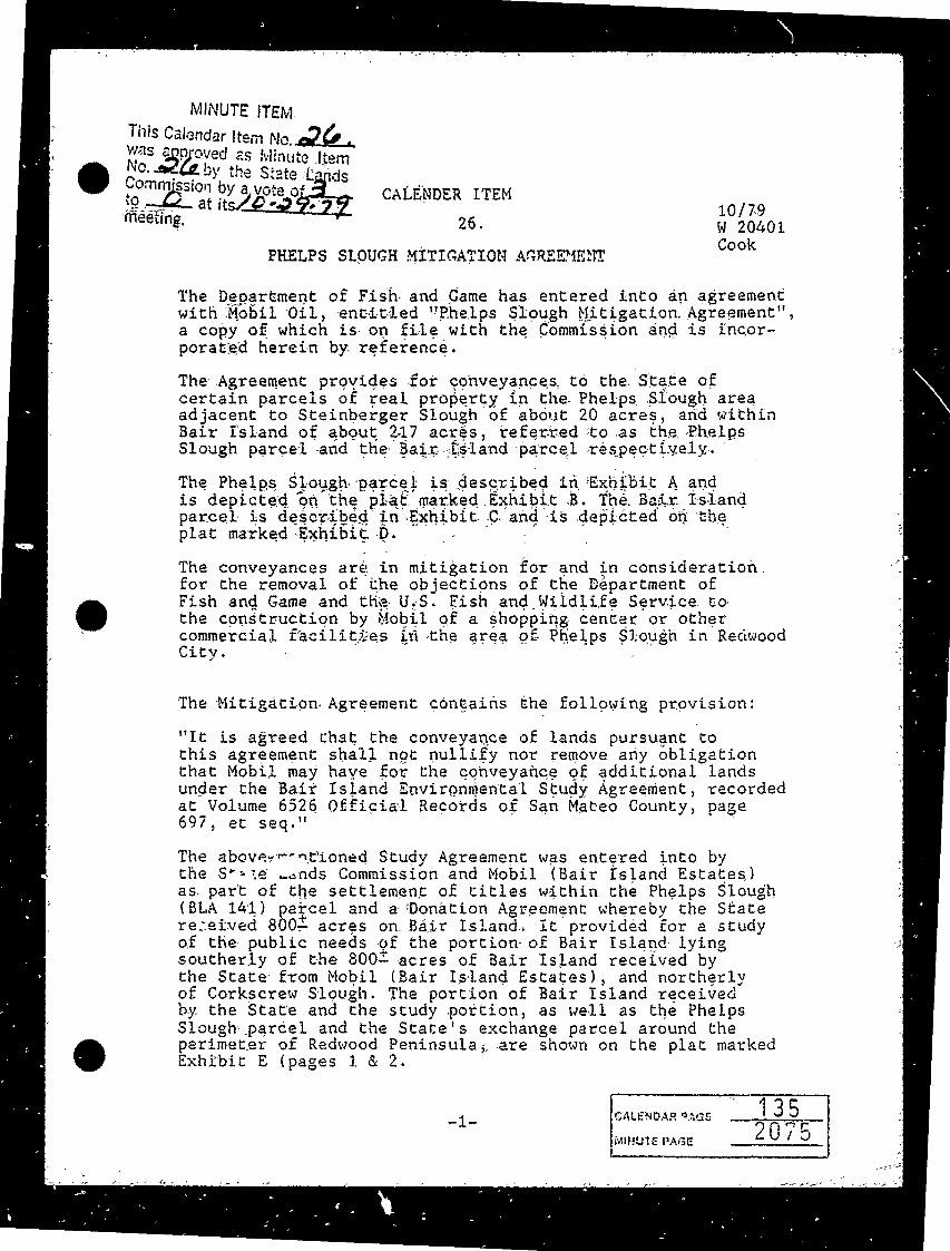
MINUTE ITEM
This Calendar Item No. 24. was anproved as Minute ItemNo. 24 by the State Lands Commission by a vote ofto at its/029. 27meeting.
CALENDER ITEM
26. 10/79 W 20401 Cook
PHELPS SLOUGH MITIGATION AGREEMENT
The Department of Fish and Game has entered into an agreementwith Mobil Oil, entitled "Phelps Slough Mitigation. Agreement"a copy of which is on file with the Commission and is incor-porated herein by reference.
The Agreement provides for conveyances, to the State of certain parcels of real property in the Phelps Slough areaadjacent to Steinberger Slough of about 20 acres, and withinBair Island of about 217 acres, referred to as the PhelpsSlough parcel and the Bair Island parcel respectively.
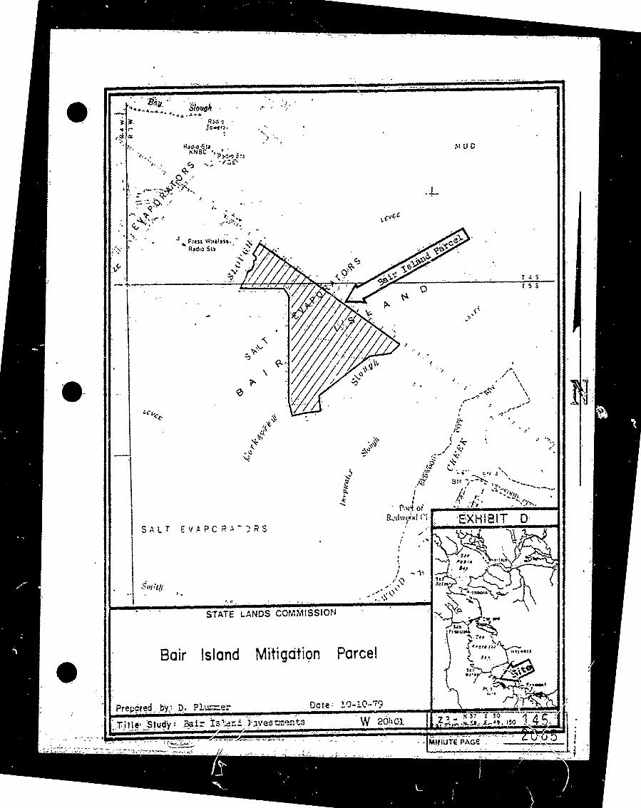
The Phelps Slough parcel is described in Exhibit A andis depicted on the plat marked Exhibit B. The Bair Islandparcel is described in Exhibit C and is depicted on theplat marked Exhibit D.
The conveyances are in mitigation for and in consideration.for the removal of the objections of the Department ofFish and Game and the U. S. Fish and Wildlife Service to the construction by Mobil of a shopping center or othercommercial facilities in the area of Phelps Slough in RedwoodCity.
The Mitigation Agreement contains the following provision:
"It is agreed that the conveyance of lands pursuant tothis agreement shall not nullify nor remove any obligationthat Mobil may have for the conveyance of additional landsunder the Bair Island Environmental Study Agreement, recordedat Volume 6526 Official Records of San Mateo County, page697, et seq."
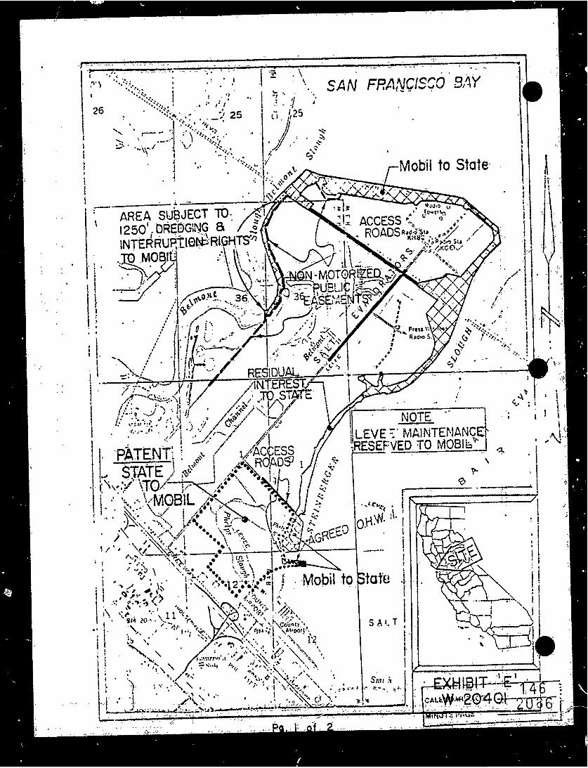
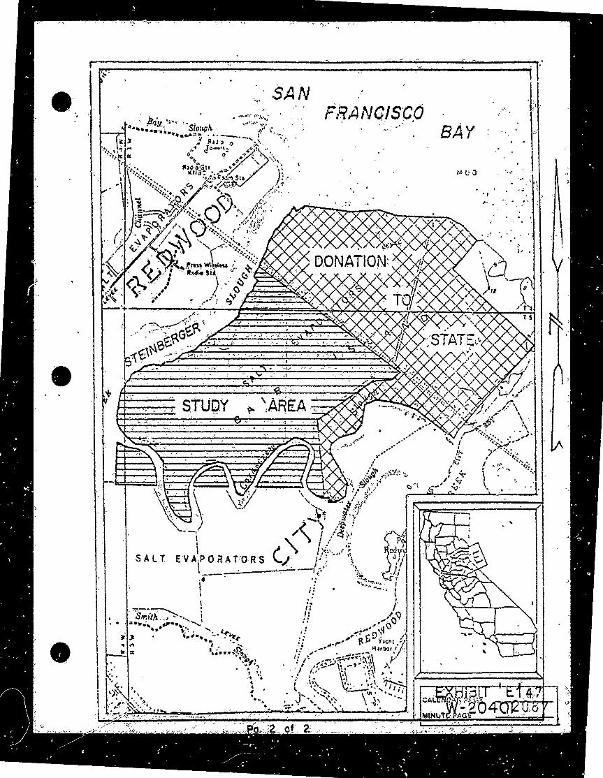
The abovementioned Study Agreement was entered into bythe State wands Commission and Mobil (Bair Island Estates) as part of the settlement of titles within the Phelps Slough(BLA 141) parcel and a Donation Agreement whereby the Statereceived 800- acres on. Bair Island.. It provided for a study of the public needs of the portion of Bair Island lyingsoutherly of the 800- acres of Bair Island received by the State from Mobil (Bair Island Estates), and northerly of Corkscrew Slough. The portion of Bair Island receivedby the State and the study portion, as well as the Phelps Slough parcel and the State's exchange parcel around theperimeter of Redwood Peninsula, are shown on the plat markedExhibit E (pages 1 & 2.
135CALENDAR AGE-1- 2075MINUTE PAGE

CALENDAR ITEM NO. 26. ( CONTD).
Pursuant to the Study Agreement, the State will receiveat least 60 additional acres of Bair Island. The Phelps Slough Mitigation Agreement provides that this 60+ acreacquisition is to be separate from, and over and above,the Bair Island parcel received under the Phelps SloughMitigation Agreement of the Department of Fish and Game.The above quoted provision is to protect the State's rightto receive the 60+ acre parcel.
In addition to the Mitigation Agreement; the Departmentof Fish and Game, the City of Redwood City and Mobil oilEstates (Redwood), Limited, have entered into an "Agreementfor Management of Storm Water Holding Basin and Mitigation Pond ("Management Agreement") pertaining to the PhelpsSlough parcel for wildlife management use consistent withflood control requirements. A copy of the agreement ison file with the State Lands Commission and is incorporated herein.
The City of Redwood City, by Resolution No. 7759, approved February 8, 1977, approved the Management Agreement andfound the Phelps Slough Mitigation Agreement to be consistentwith the interests of the City and of the Redwood CityGeneral Improvement District No. 1-64.
The Phelps Slough Mitigation Agreement is subject to thefollowing condition:
"Finding by the State Lands Commission that the mitigation plan is consistent with Bair Island Environmental Study Agreement (Volume 6526 of San Mateo County Official Records, page 697 et seq. )"
The Department of Fish and Came agrees that the Phelps Slough and Bair Island parcels should pass to the State in its sovereign capacity as tidelands and submerged landwith control and possession to be in the Department . To accomplish this, it is necessary that the State Lands Com-mission accept the deeds (copies of which are on file withthe State Lands Commission and are incorporated herein by reference) and execute a Transfer of Control and Possession to the Department for the uses specified in the said Mitigationand Management Agreements.
-2-CALENDAR 73-C
2076 136
CALENDAR ITEM NO. 26 (CONTD.)
The Phelps Slough Mitigation Agreement provides for conditions,the occurrences of which will require cancellation and reconveyance of the parcels described in the deeds to Mobil,said conditions will be binding upon the State Lands Commission when it accepts the deeds pursuant to the Agreement. Onecondition for such cancellation consists of Mobil's optionto not exercise the privileges and entitlements of theUnited States Army Corps of Engineers permit within 12months of its issuance. Another results from a possibleFinal judgement setting aside the Mitigation Agreementor United States Army Corps of Engineers permits Nos. 10354-49,10551-49 within 7 years of the Close of escrow.
Mobil is to provide title insurance in the amount of $500,000insuring fee title in the State of California to the PhelpsSlough parcel and title insurance in the amount of $432,000insuring fee title in the State of California to the BairIsland parcel. Mobil is to restore the Bair Island parcelto tidal action within 5 years of close of escrow or incase of litigation regarding this parcel at the conclusionof said litigation.
Staff has reviewed the matter in some detail and is of the opinion that the proposed transaction and findings are in the best interests of the State and within the legallyconsitituted powers of the State Lands Commission pursuant to Division 6 of the P. R. C., including Section 6301 thereof.
EXHIBITS : Land Description - Phelps Slough Parcel.Plat Map - Phelps Slough Parcel.Land Description - Bair Island Parcel.
D. Plat Map - Bair Island Parcel. Plat Maps, Pages 1 & 2 - Redwood Peninsula.
IT IS RECOMMENDED THAT THE COMMISSION:
1 . FIND, PURSUANT TO PARAGRAPH 9(c) OF THE PHELPS SLOUGH MITIGATION AGREEMENT, THAT THE MITIGATION PLAN IS CON-SISTENT WITH THE BAIR ISLAND ENVIRONMENTAL STUDY AGREEMENT (VOL. 6526 OF SAN MATEO COUNTY OFFICIAL RECORDS, PAGE 697, ET SEQ. ) .
2. AUTHORIZE THE ACCEPTANCE AND RECORDATION OF THE GRANT DEEDS TO THE STATE OF THE PHELPS SLOUGH PARCEL AND' THE BAIR ISLAND PARCEL. SAID PARCELS BEING MORE PARTICULARLY DESCRIBED IN EXHIBITS A AND C, RESPECTIVELY.
CALENDAR PAGE
-3- 2077 137
4
CALENDAR. ITEM. NO. 26. ( CONTD)
3. AUTHORIZE THE TRANSFER OF CONTROL AND POSSESSION OF THE REAL PROPERTY DESCRIBED IN SAID DEEDS TO THE CALIFORNIA
DEPARTMENT OF FISH AND GAME:
AUTHORIZE THE STATE LANDS COMMISSION STAFF AND/,OR THEOFFICE OF THE ATTORNEY GENERAL TO TAKE ALL FURTHER STEPS WHICH MAY BE REASONABLY NECESSARY AND CONVENIENT TO IMPLEMENT THE TRANSACTION DESCRIBED ABOVE, INCLUDING BUT. NOT LIMITED TO EXECUTION OF DOCUMENTS OF TITLE, RECORDATION, ESCROW. INSTRUCTIONS AND. APPEARANCES IN. ANY LEGAL PROCEEDINGS BROUGHT CONCERNING THE ABOVE TRANSACTION.
5. FIND THAT THE TRANSACTION IS CATAGORICALLY EXEMPT FROM PREPARATION OF AN EIR IN THAT THE PROJECT INVOLVES THE ACQUISITION OF LANDS FOR FISH AND WILDLIFE CONSERVATION PURPOSES INCLUDING. PRESERVATION OF FISH AND WILDLIFE HABITAT, (14 CAL, ADM. GODE SECTION 15113) AND THE. PROJECT INVOLVES ACTION BY A REGULATORY AGENCY, THE DEPARTMENT OF FISH AND GAME, FOR PROTECTION OF NATURAL RESOURCES AND THE ENVIRONMENT, (14 CAL. ADM. CODE SECTIONS15107, 15108.
CALF'IC, 1 PAGE-4- 2078
138
XXMIBIT "A"
DESCRIPTION
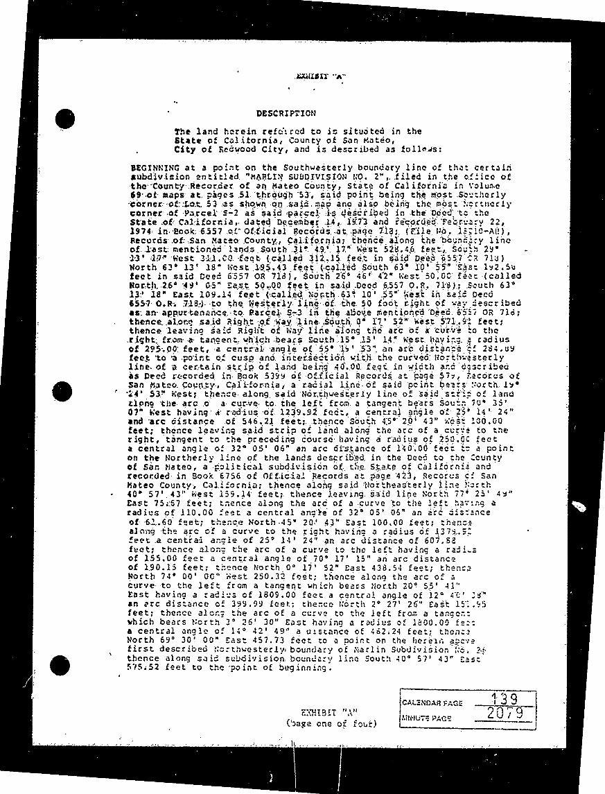
The land herein referred to is situated in the State of California, County of San Mateo,City of Redwood City, and is described as follows:
BEGINNING at a point on the Southwesterly boundary line of that certainsubdivision entitled "MARLIN SUBDIVISION NO. 2", filed in the office ofthe County Recorder of an Mateo County, State of California in Volume69. of maps at pages S1 through 53, said point being the most Southerlycorner of Lot. 53 as shown on said. map and also being the most Serenelycorner of Parcel 's-2 as said parcel is described in the Dded to theState of California, dated December 14, 1973 and recorded February 22,1974 in Book: 6557 of Official Records at page 718: (File. No. 1: 10-All),Records of San Mateo County, California; thence along the boundary lineof last mentioned lands South 319 49 17" west 528. 46 feet, Sough 29.13' 15" west 311. CO. feet (called 312.15 feet in said Deep 6557 68 713)North 63* 13' 18" west 195.43 feet (called South 63" 10' 55" sAs: 1y2.Sofeet in said Deed 6557 OR 718), South 26 46 42" west 50:00 fees ( calledNorth. 26 49' 65" East 50.00 feet in said Deed 6557 0. R. 719) ; South 63.13 18" East 109.14 feet (called North 63. 10' 35-"west in said Deco 6557 0.R. 718.) to the Westerly line of the 50 foot right of way describedas an appurtenance to Parcel S-3 in the above mentioned Deed. 6957 OR 716;thence alone said Right of way line South 0 17' 52" west 571.92 feet;thence leaving said Right of Way line along the arc of a curve to theright from a tangent, which bears South 15. 15' 1' 14" West having a radiusof 295 00 feet, a central angle of $5. 1 ' 53" an arc distance d: 284. uyfeet to a point of cusp and intersection with the curved No; theeasterlyline of a certain strip of land being 40.00 feet in width and describedas Deed recorded in Book 5399 of Official Records at page $7:, Racorus of San Mateo County, California, a radial line of said point beats North ly.$24' 53" West; thence along said Northwesterly line of said strip of landzlong the arc o a curve to the left from a tangent bears South 70* 35'07" west having a radius of 1239.92 fee:, a central angle of 23' 14' 24"and are distance of 546.21 feet; thence south 45. 201 43" ness 100.00feet; thence leaving said strip of land along the arc of a curve to theright, tangent to the preceding course. having a radius of 250.06 feeta central angle of 32 05' 06" an arc distance of 140.00 fect is a pointon the Northerly line of the lands described in the Deed to the Countyof San Mateo, a political subdivision of the State of California andrecorded in Book 6756 of Official Records at page 423, Recorus c: sanMateo County, California; thence along said Northeasterly line North40 57'. 43" west 159.14 feet; thence leaving. said line North 77* 23' 4y"East 75.:67 feet; thence along the arc of a curve to the left having aradius of 110.00 feet a central angle of 32 05' 06" an are distanceof 62.60 feet; theace North 45. 20' 43" Sast 100.00 feet; thenet along the arc of a curve to the right having a radius of 1374.":feet a centrai angle of 25' 14' 24" an arc distance of 607. 68fret; thence along the arc of a curve to the left having a radiusof 155.00 feet a central angle of 70' 17' 15" an arc distanceof 190.15 feet; thence North 0* 171 52" East 438. 54 feet; thenceworth 74. 00' 00" West 250.32 feet; thence along the arc of acurve to the left from a tangent which bears North 20. 55' 41"East having a radius of 1809.00 feet a central angle of 120 40' 3y."an are distance of 39.99 feet: thence North 20 27' 26" East 19:.95 feet; thence along the arc of a curve to the left from a tanger:which bears North 30 26' 30" East having a radius of 1800.00 fe::a central angle of 14 42' 49" a distance of 462.24 feet; thenceNorth 69 30' 00" East 457.73 feet to a point on the herein anevefirst described Northwesterly boundary of Marlin Subdivision Ro. 21thence along said subdivision boundary line South 40 57' 43" East575.52 feet to the point of beginning.
CALENDAR PAGE
EXHIBIT "A" MRMUTE PAGE 2079
(bage one of four)
139
Reserving, however, unto the Granter, its successors and assigns,over all of the above described lands a perpetual right to collect and impound storm waters from whatever source and no matter, whereoriginating to be drained onto the property, but not to exceed 100year flood flows of 2, 400,000 cubic feet annually with a peak :c:700 cubic feet per second over a one (1) hour period; including,but without limiting the generality of the foregoing, the rightto excavate and shape the lands for such purposes, together withthe right at all times to enter upon and use said: lands to maintainand operate the aforesaid drainage basin, and such facilities andimprovements as may be installed thereon.
Further reserving unto the Grantor, its successors and assigns. overthe said hereinabove described property an easement for: drainage purposes and incidents thereto, including the right to construct,enclose, operate and maintain a pumphouse structure and similar facilities over and across the parcel of land described as follows:
BEGINNING at the westerly terminus of that certain course first:herein above described as North 63 13' 18" west 195.43 feet (calledSouth 65 10 55" East 192.56 feet in said Deed: 6557 0. R. 718);;thence Northeastery perpendicular to said course North 26 46', $2"East. 50.00 feet; thence South 63. 13' 18" East parallel to saidcourse 95.00 feet: thence North 260 46' 42" East 230.00 foe:;thence South 63. 13' 18" East 92.82 feet, more or less, to a pointon the boundary line of the herein above furst mentioned Parcel s-2;thence. along. said boundary line South 25" 131 17" West 280.10 feet,more or less, to an angle point in said boundary line of Parcel S-2;thence continuing along said boundary line forthwesterly to the point of beginning.
Further reserving unto the Grantor, its successors and assigns, from the said hereinabove described property an easement for an undergroundpipeline and discharge structure between Steinberger Slough and thelands first hereinabove described, including the right to enter uponsaid lands to install, construct, operate and maintain such facilities over and across the following described parcel of iand:
COMMENCING at the herein above first described point of beginning atthe said most Northerly corner of Parcel S-2 and being the point ofbeginning of the herein described strip easement; thence South ?!' 417" West 20.00 fees; thence North 75. 00' 00" West 240.00 feet: thence
North 15 00' CO" East 50.00 feet; thence South 75 00' 00" Sas: 200.11 feet, more or less, to the herein above first described Southwesterlyboundary line of said Marlin Subdivision No. 2; thence Southeastarlyalong said boundary line South 40. 57' 43" East $512', more or less,to the point of beginning.
EXHIBIT "A"L
( nape two of four)
CALENDAR PAGE
2090IMINUTE FACE
140
Further reserving unto the Grantee ; Its successors and assigns, fromthe said here instove described property four (4) relocatable drainageeasements, each fifty (50) feet in width, together with all necessarysecondary easements for operation and maintenance purposes, the initiallocations of which said easements are as follows:
EASEMENT
BEGINNING at the westerly terminus of that certain course first here inabove described as North 74 00" co" west 250.32 feet; thence along. the line of said strip easement North 66 00' 00" East 175.00 Beet;thence North 24. co' 00 Kest 50.00 feet; thence South 66. Col 80" West127.00 feet, more or less to the curved line as first here in abovedescribed having a radius of 1809.00 feet; thence Southwesterly along said curved line to the point of beginning.
EASEMENT II:
BEGINNING at the Southerly terminus of that certain course firsthere in above described as North 2* 27' 26" East 151.95 feeny grenceSouthwesterly along the arc of a curve to the right from a. tangentwhich bears South 8. 1533" west having a radius of 1309.00 feeta central angle of 2" 03' 31" an arc distance of 65.00 feet to thetrue point of beginning of the here in described strip easement;thence along said easerent line South 47 00" 00" East 160.CO feet;thence south 43. 30' 00" west 50:00 feet; thence North $7. CO! 20*West 129.06 feet, more or less, to the here in described curve, linehaving a radius of 1809.00 feet; thence Northerly along _ !curved line to the point of beginning.
EASEMENT III :
BEGINNING at the Northerly terminus of that certain course firs:there inabove descrined as North 20 27' 26" East 151.95 feet; thence Northerly along one arc of a curve to the left from a tangent whichbears Worth 3. 25' 30" East having a radius of 1800.00 fege a centralangle of 7. 19' 16" an arc distance of 230.00 feet to the truepoint of beginning of the here in described easement; thence. North83 00 00" East 135.00 feet; thence North 70 00" 00" west so. cofeet; thence South 839 00' 00" west 102.97 feet, more or less, to the above described curve line having a radius of 1800.00 feet;thence Southerly along said curved line to the true point of beginning.
EASEMENT IV:
BEGINNING at the Westerly terminus of that certain course first hereinabove described as North 690 60' 00" East 457.73 feet; thence ding the line of said strip easement South 76* 00' 00" East 145. 0d feet;thence South 140 0' 00" west 50.00 fect; thenice North 76. Go' C.* West 122.32 feet, more or less, to the curved line here in above described as having a radius of 1800.00 feet; thence Northerly along said curvedline to the point of beginning.
EXHIBIT "A" CALENDAR PAGE
(nage three of four) 2001 MINUTE PACE
141
Further reserving unto the Grantor, it ; successors and assigns,from the said hereinabove described property two (2) relocatesle easements for drainage inlets, each fifty (50) feet in width,together with all necessary secondary casements for operation andmaintenance purposes, the initial locations of which are as fellows:
EASEMENT "A":
BEGINNING, at a point on that certain course herein above described"s South 0. 17' 52." West 'S71.91 feet, said point bears kosh ?. 17'52" East 155.00 feet from the Southerly terminus of said course;thence, North 89. 42' 08" west 60.00 feet; thence North 0' 17' 152"East 50.00 feet; thence South 89 42' 08" East 60.00, feet; thenceSouth 0' 19. 5:52" West 50.00 feet to the point of beginning.
EASEMENT B":
The Easterly line being described as follows:
BEGINNING at the point of cusp of the curve as first herein above described and being the Southwesterly terminus: of the curved coursedescribed as having a radius of 295.00 feet and a central angle of55" 19' 53"; thence along the most Easterly line of said striseasement North 19. 24' 53" West 140.00 feet to the Southwesterlyterminus of the first herein above described curved course having a radius of 155.CO feet and central angle of "0" 171 15" the nesterlyline of said strip easement being parallel co and 50. 16 feet measuredperpendicularly from the herein described Easterly easement fire andterminating at the curvilinear lines as first above describerd, havinga radius of 1239.92 feet on the South and 1379.92 feet on the North.
Further reserving unto Grantor, its successors and assigns, & publicright of way easement extending over and. above a portion of the said hereinabove described property 'and being within a strip of landmore particularly described as follows:
The most Northerly sideline limits of said strip bears South #5. 00.00" West from the Southerly terminus of the course first hereinabovedescribed as South 0. 171 52" Wes: 571.91 feet and extending _17.83feet to a point on the line of curvature first hereinabove describedas having a radius of 155.00 feet, a central angle of 709 17' 15",A radial line at said point bears North 55 07' 37" West.
The most Southerly sideline of said strip begins at a point on theline of curvature first hereinaboved described as having a radius of1239.92 feet, a central angle of, 25 14' 24" said point being 161.82feet along said curve from the Norths ly terminus of said curve, A radial line as said sideling point bears forth 26 53' 33" writ,the said Southerly sideline of said strip bears worth 75. 30' ?)"West from said gelat 199. 43 feet to a point on the line of curvaturefirst hereinabove described as having & radius of 1379.92 feet, acentra'. angle of :5 14' 24", a radial Tine ut said point bears forth33. 07' 00" nest.
EXHIBIT ","
(maze four of four) 142CALENDAR PAGE
2062MINUTE PACS
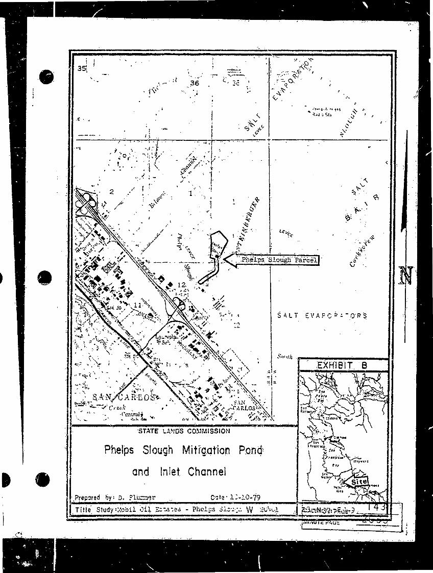
EVAPORATOR
6 .
SALI LEVEL SLOUGH
Channel
SALT . ... R
STEINBERGER Phelps Slough Parcel
Corkscrew
N 120
11
SALT EVAPO : ORS
AS HOUDARY
EXHIBIT. B
SAN CARLOS 9827 Creek
Central
STATE LANDS COMMISSION
Phelps Slough Mitigation Pond Itagver#
and Inlet Channel
Prepared by: D. Plummer Date . 1:-10-79 1431Title Study :Mobil off Encases - Phelps Sioux W 204
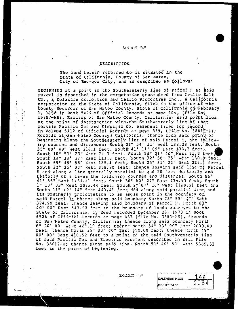
EXHIBIT "C"
DESCRIPTION
The land herein referred to is situated in the State of California, County of San Mateo,City of Redwood City, and is described as follows:
BEGINNING at a point in the Southeasterly line of Parcel # as said parcel is described in the corporation grant deed from Leslie SaltCo., a Delaware corportion and Leslie Properties Inc. , a Californiacorporation to the State of California, filed in the office of the County Recorder of San Mateo County, State of California on February1, 1958 in Book 5425 of Official Records at page 10y, (File No!15987-AB) , Records of San Mateo County, California; said point liesat the point of intersection with the Southwesterly line of that certain Pacific Gas and Electric Co. easement filed for record. in Volume 5112 of Official Records at page 339, (File No. 38612-2); Records of San Mateo County, California; thence from said point of beginning along the Southeasterly line of said Parcel !, the follow-ing courses and distances: South 210 54' 11" west 138.23 feet, South35 00' 49" West 216.1 feet, South 410 11' 09" East 138.2 feet.,. South 100 51' 23" West 74.3 feet, South 55 311 40" West d1. 3 feet, South 1jo 18' 17" East Ill.8 feet, South 32 50' 25" west 130.y feet,South 59 491 58" West 185.1 feet, South 25 31' 33" West 227.4 feet,South 32 35' 00" West 378.80 feet; thence leaving said line of Parcel H and along a line generally parallel to and 20 feet Northerly and Easterly of a levee the following courses and distances; South 86.41' 56" East 1434.41 feet, South 30 50! 27" East 239. 93 feet, South 1 101 33" Rest 20:5. 44 feet, South 20 07' 16" west 1188. 51 feet and South 110 42' 14" East 443.41 feet and along said parallel line and it's Southerly prolongation to an angle point in the boundary ofsaid Parcel H; thence along said boundary North 78 55' 47" East374.90 feet; thence leaving said boundary of Parcel H, North 830401 00" East 543.98 feet to the boundary of lands conveyed to theState of California, by Deed recorded December 28, 1973 , Book6526 of Official Records at page 632 (File No. 3383-AH) , Fecords of San Mateo County, California; thence along said boundary North6 20" 00" West 489.19 feet; thence North 54 10' 00" Eas: 2030.00 feet; thence North $5 00' 00" East 650.00 felt; thence lic: th 4y00' 00" East 410.52 feet to a point in the said Southwesterly line of said. Pacific Gas and Electric easement described in said File No. 38612-2; thence along said line, North 53. .40' 50" hes: 5385.53feet to the point of beginning.
EXHIBIT "C" CALENDAR PAGE
MINUTE PACK 2084 1.44
Bay" Slough
ROWVR.4 W MUC
"Pyong 212
LEVEE
EVAPORATE Press Wireless
SLOUGH Fair Island Parcel
AND EVAPORATORS
SALT
A I N LEVEE
Corksofew CREEK
Part of
Redwind fi EXHIBIT D SALT EVAPCRA "ORS
Smith
STATE LANDS COMMISSION
Bair Island Mitigation Parcel Site
Date: 10-10-79Prepared: by : D. Plummer W 201:01 145.Title Study : Bair Is band Javestments my. 1-19. 150
-MINUTE PAGE
26
SAN FRANCISCO BAY
"25 1 25
Slough -Mobil to State
Belmont
AREA SUBJECT TO- ACCESS 1250', DREDGING & ROADS Rad SU
INTERRUPTION RIGHTS'S TO MOBIL
NON- MOTORIZED - PUBLIC
36 Belmont 3 EASEMENT RE
Press W
Belmont.SALT SLOUGH RESIDUAL INTERESTS TO STATE
EVA NOTE
LEVE MAINTENANCE"Channel-RESERVED TO MOBIL
PATENT ACCESSROADS' 1
STATE Belmont ABTO
MOBIL ..LEVEL
LEVEE
STEINBERGERAGREED JO.H.W. .
yungis Mobil to State INDL . PALS
SALT
2-4. 45 EXHIBIT E146 CALLW-20401 2036
.P.q.. of 2
SAN
FRANCISCOBay * "Slough
BAY
EVAPO
DONATIONglass WillowRadio 57
REDWOODSLOUGH
STEINBERGER
STUDY A AREA
REEK
Deepwater...... Slough
SALT EVAPORATORSCITY Red
Smith
REDWOOD RAW HarborR JW
CALLA BIGLT E147 MINUTENAG 20402087
Po.: 2 of 2