Embed Size (px)
Citation preview

MINTO ARCADIA MIXED-USE DEVELOPMENT 370 Huntmar Drive, Demonstration Report
Prepared April 2011
Revised October 2011

MINTO ARCADIA MIXED-USE DEVELOPMENT
370 Huntmar Drive, Demonstration Report April 2011
Revised October 2011
Prepared by: FoTenn Consultants Inc. 223 McLeod Street, Ottawa, ON, K2P 0Z8 Prepared for: Minto Commercial Properties Inc. 200-180 Kent Street, Ottawa, ON, K1P 0B6
1 | P a g e
TABLE OF CONTENTS 1. INTRODUCTION ................................................................................. 2 2. OVERVIEW OF THE APPLICATION ........................................................ 3 3. DEVELOPMENT PROPOSAL ................................................................. 4 4. SITE CONTEXT & SURROUNDING USES ............................................... 7 4.1. Site Context ............................................................................. 7 4.2. Surrounding Uses ..................................................................... 7 5. REVIEW OF POLICY AND REGULATORY DOCUMENTS ........................... 8 5.1. City of Ottawa Official Plan (2003, Consolidated 2007) ................. 8 5.2. Official Plan Amendment No. 76 (June 2009) ............................... 8 5.3. Kanata West Concept Plan (KWCP) ............................................. 9 5.4. City of Ottawa Comprehensive Zoning By-law (2008-250) ........... 12 6. RESPONSE TO THE SITE CONTEXT AND APPLICABLE POLICIES AND
REGULATIONS ................................................................................. 15 6.1. Land Use, Building Siting and Massing ....................................... 15 6.2. Block Pattern .......................................................................... 16 6.3. Parks, Open Space and Streetscape .......................................... 16 7. THE ENVIRONMENTAL ASSESSMENTS (EAs) ...................................... 17 8. KANATA WEST LANDOWNERS ......................................................... 18 9. TECHNICAL STUDIES ....................................................................... 19 9.1. Transportation Impact Study – Delcan, June 2008 ...................... 19 9.2. Site Servicing Report – IBI Group, November 2010 ..................... 19 9.3. Stormwater Management Report – IBI Group, November 2010 ..... 20 9.4. Geotechnical Study – Paterson Group, July 2007 ....................... 20 10. CONCLUSIONS ............................................................................. 21
2 | P a g e
1. INTRODUCTION The following is a Demonstration Report prepared in accordance with Section 4.7.2 of the Kanata West Concept Plan (KWCP). The purpose of the report is to assess the appropriateness of the proposed mixed-use development and the requested Zoning By-law Amendment in the context of the surrounding community (existing and planned) and the applicable policy and regulatory framework. Certain sections of this report rely on the information presented in the following studies, plans and reports, which were prepared in support of the Zoning By-law Amendment application:
• A Draft Plan of Subdivision prepared by Stantec Geomatics Ltd. (created on August 4, 2006 and most recently updated September 2011);
• A Concept Plan illustrating Proposed Land Use prepared by FoTenn (Oct- ober 2011);
• A Transportation Impact Study prepared by Delcan Corporation (June 2008);
• A Site Servicing Report prepared by IBI Group (November 2010);
• A Stormwater Management Report and Interim SWMF Design Brief prepared by IBI Group (November 2010); and
• A Geotechnical Study prepared by Paterson Group Inc. (July 5, 2007)
The findings of the studies and reports listed above are summarized in Section 9. For the purpose of this report, the term Consulting Team refers to the above noted consultants.

3 | P a g e
2. OVERVIEW OF THE APPLICATION This report is prepared in support of a Zoning By-law Amendment for approximately 14.7 hectares (36.2 acres) of land located northeast of the intersection of Huntmar Drive and Highway 417 (Figure 1). Approval of this application will permit the proponent (Minto Communities Inc.) to obtain the other approvals (e.g. Plan of Subdivision and Site Plan) and permits (e.g. Building Permit) required to construct a mixed-use development including residential, office and retail uses. The proposed development comprises approximately 21,321 m2 (229,505 ft2) of office space, 2,973 m2 (32,000 ft2) of retail space and 416 residential dwelling units. The site is currently zoned Development Reserve (DR) in the City of Ottawa Comprehensive Zoning By-law (2008-250). The purpose of this zone is to recognize lands intended for future urban development. The proposed Zoning By-law Amendment would rezone the site from Development Reserve (DR) to Mixed-Use Centre (MC).
Figure 1 - The Site
---- Site --- --- --- KWCP Boundary
4 | P a g e
3. DEVELOPMENT PROPOSAL The Draft Plan of Subdivision prepared by Stantec Geomatics Ltd. illustrates the manner in which the site will be subdivided. It includes 15 blocks, of which 7 are developable; representing a net developable area of approximately 12 hectares (refer to Page 4). A Concept Plan (refer to Page 5) reflects the details of the Draft Plan of Subdivision and provides visual detail regarding how the site may be developed to meet the vision, guidelines and design principles set out in the Kanata West Concept Plan (KWCP), and in particular Chapter 4 -Analysis and Implementation- of the KWCP Report. The Plan illustrates 14 Dual Terrace Home buildings (each building has a range of 16 – 32 units) and 8 Gallery Suite buildings (each building has 8 units) for a total of 416 residential dwellings on the site. The Dual Terrace Homes and Gallery Suite buildings are four (4) storeys in height. All of the residential uses will be accommodated by at least 1.4 parking spaces per dwelling unit (1.2 resident and 0.2 visitor), either in an underground garage or in a surface lot (to be determined). Three 3-storey office buildings are proposed, each with a floor plate of 2,369 m2 (25,500 ft2). The buildings have a combined floor area of approximately 21,321 m2 (229,505 ft2). The office buildings are proposed along Campeau Drive with two buildings on the west side of the proposed BRT station and one building on the east side. Parking for the building shall be provided in surface lots. A 1-storey commercial/retail building with a floor area of approximately 1,719 m2 (18,500 ft2) is proposed at the intersection of Campeau Drive and Huntmar Drive; it will be designed as a gateway feature. A second commercial (retail) building with a slightly smaller floor area (1,254 m2 / 13,500 ft2) is proposed adjacent (to the north) of the proposed BRT station. The residential subdivision on the north side of Campeau Drive is connected to the lands south of the site via Streets 16 and 17, which traverse the site in a north-south direction. Streets 16 and 17 are Major Collector roads with rights-of ways (ROW) of 26 metres. A small network of local roads is proposed to provide access to the residential, office and retail uses. A portion of the south and east parts of the site are within the Feedmill Creek and Carp River floodplains, respectively.


TANNISMINTO - ARCADIA SITE PLANSCALE 1:2500
OCTOBER 2011
Commercial Development
Residential Development
Office Development
Open Space
Foliage
Transit Station

7 | P a g e
4. SITE CONTEXT & SURROUNDING USES As a developing community, the Kanata West area is characterized by new development comprised of a mix of uses and densities, and in contrast, large expanses of rural and agricultural land currently used for single family dwellings and other types of rural and agricultural uses.
4.1. Site Context
The site is located north of Highway 417 within the northeast and quadrant of the Kanata West Concept Plan (KWCP) area. The development is bound by Carp River to the east, Feedmill Creek to the south, Huntmar Drive to the west and the future extension of Campeau Road to the north. The site was formerly used for agricultural purposes, but is currently vacant and partially cleared. As a result, there are very few trees located on the site. The land is relatively flat, sloping from Huntmar Drive toward the Carp River boundary.
4.2. Surrounding Uses
With the exception of the Kanata Wesleyan Church, the majority of the land located between Highway 417 and Feedmill Creek (the site’s southern boundary) is currently vacant. However, re-zoning and site plan control applications have been submitted for a proposed mixed-use development. The northern boundary of the site is the future Campeau Drive extension, beyond which is Minto’s future Arcadia residential development, which is draft approved and at various stages of pre-construction. The lands west of the site, on the opposite side of Huntmar Drive, are designated Mixed-Use Centre and Enterprise Area; these lands will development with a mix of employment, retail, and residential uses in the future. East of the site, on the opposite side of the Carp River, are the lower density residential communities of Heritage Hills and Beaverbrook and the Kanata Centrum Plaza regional shopping centre and Transit Station.

8 | P a g e
5. REVIEW OF POLICY AND REGULATORY DOCUMENTS 5.1. City of Ottawa Official Plan (2003, Consolidated 2007)
The City of Ottawa Official Plan (OP) was approved by City Council in 2003 and consolidated in 2007. The OP designates the central portion Kanata West (including the site), as Mixed-Use Centre. The Mixed Use Centre designation is applied to lands that are strategically located along major roads and the City’s rapid-transit network. It is intended that these areas undergo substantial growth in the form of compact, mixed-use development and that they become focal points of activity at both the local and regional scales. Transit-supportive land uses are permitted in the Mixed Use Centre designation, including: offices, schools, hotels, hospitals, large institutional buildings, community recreation and leisure centres, daycare centres, retail uses, entertainment uses, services, high- and medium-density residential uses and mixed-use development involving any of the above.
Figure 2 - City of Ottawa Official Plan Schedule B (Urban Land Use) 5.2. Official Plan Amendment No. 76 (June 2009)
The City of Ottawa recently undertook a 5-year review of their Official Plan, which resulted in the passing of Official Plan Amendment (OPA) 76 on June 24, 2009. OPA 76 was subsequently approved by the Ministry of Municipal Affairs and Housing on December 24, 2009, subject to several modifications. Several appeals to the Official Plan Amendment have been filed with the Ontario Municipal Board, which are currently being heard. In the meantime, the new policies must be considered to as they inform the review of development proposals. The Mixed Use Centre designation noted above continues to apply to the site and the policies associated with these designations have not been significantly
---- Site ---- Mixed-Use Centre ---- Enterprise Area
9 | P a g e
altered. One change to the Mixed-Use Centre designation worth noting is the addition of Policy 7d in Section 3.6.2, which states:
• “Mixed-Use Centres will optimize the use of land through provisions for compact mixed-use development. The zoning by-law and community design plans will: [...] d) Require all development to meet the minimum target densities set out in Section 2.2.2, policy 7.”
The site is not located in an area subject to Figure 2.3 of Section 2.2.2; therefore there are no applicable density requirements in the Official Plan. 5.3. Kanata West Concept Plan (KWCP)
In the fall of year 2000, the Kanata West lands were brought into the Urban Area through Amendment 9 to the former Region of Ottawa-Carleton Official Plan (OP). Amendment 9 required that a concept plan be prepared to guide zoning, subdivision and public expenditures in the area. Further, the Concept Plan was to produce an innovative mixed use urban development where people will be able to live, work and play. The result of these objectives is the Kanata West Concept Plan (KWCP). The general land use and development principles of the Kanata West Concept Plan were completed in September 2002 and approved by City Council on March 26, 2003. The KWCP is the outcome of input from two Steering Committees, together with environmental, engineering, transportation, market feasibility, urban design and land use studies and a significant public consultation process involving various stakeholders.
Concept Plan Designations
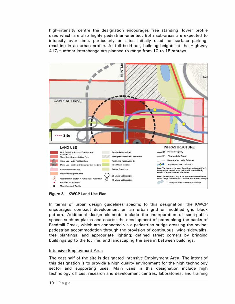
The site is designated High Profile Employment, Entertainment and Leisure Hub, Intensive Employment Area and River Creek Corridors in the Kanata West Concept Plan (Figure 3). High Profile Employment, Entertainment and Leisure Hub
The west half of the site is designated High Profile Employment, Entertainment and Leisure Hub in the KWCP. The purpose of this designation is to take advantage of the high visibility and accessibility that result from being located close to both Highway 417 and the future transitway. The designation also aims to reinforce the presence of the Scotiabank sports and entertainment complex, which is located southeast of the subject lands. Specific uses envisioned for lands within this designation include employment, personal and community-servicing uses, leisure and entertainment uses, retail and theme/specialty commercial, hotels and spas, and apartments. It is anticipated that highest-intensity uses will be located at the Highway 417/Huntmar Drive interchange and along the transitway. Outward from this
10 | P a g e
high-intensity centre the designation encourages free standing, lower profile uses which are also highly pedestrian-oriented. Both sub-areas are expected to intensify over time, particularly on sites initially used for surface parking, resulting in an urban profile. At full build-out, building heights at the Highway 417/Huntmar interchange are planned to range from 10 to 15 storeys.
Figure 3 – KWCP Land Use Plan In terms of urban design guidelines specific to this designation, the KWCP encourages compact development on an urban grid or modified grid block pattern. Additional design elements include the incorporation of semi-public spaces such as plazas and courts; the development of paths along the banks of Feedmill Creek, which are connected via a pedestrian bridge crossing the ravine; pedestrian accommodation through the provision of continuous, wide sidewalks, tree plantings, and appropriate lighting; defined street corners by bringing buildings up to the lot line; and landscaping the area in between buildings. Intensive Employment Area
The east half of the site is designated Intensive Employment Area. The intent of this designation is to provide a high quality environment for the high technology sector and supporting uses. Main uses in this designation include high technology offices, research and development centres, laboratories, and training
---- Site

11 | P a g e
centres. Supporting uses include personal and community-servicing uses, such as banks and convenience stores, and retail and specialty commercial. The built form within Intensive Employment Areas is intended to consist of medium profile (4-6 storeys) buildings which address the street, creating a strong pedestrian environment which encourages connectivity with transit and the High Profile Hub. As in the High Profile Hub, it is anticipated that over time, surface parking lots will be redeveloped to more intensive uses. In terms of design guidelines, the KWCP encourages a grid street pattern with a long east-west axis and blocks with lengths approximately twice their width. Regularly spaced connections across major streets are also supported to create porosity throughout the core. Similar to in the High Profile Hub, small “vest pocket” parks, entry plazas, and courts are desired to provide semi-public space and recreation paths along Feedmill Creek are encouraged. Further, to achieve a pedestrian friendly environment, the KWCP again promotes bringing buildings up to lot lines and street corners and providing appropriate sidewalk widths, tree plantings, and lighting. River Creek Corridors
Feedmill Creek runs east-west through the site. The creek corridor is a significant ecological feature which provides aquatic habitat as well as aesthetic and social benefits. More uniquely, Feedmill Creek has sensitive cold/cool water habitats and contributes significantly to the Carp River baseflow. The corridor designation includes the Creek, the stream valley banks on either side of the Creek, and an additional 5 metre wide buffer zone on either side. On average, this corridor is approximately 80 metres in width. The aim of the River Creek Corridors designation is to protect and restore the existing vegetation and water quality of Poole Creek, Feedmill Creek, and the Carp River. In order to achieve these goals the KWCP contains a number of guidelines related to general environmental management, terrestrial features, aquatic features, the creeks, and the river.
Demonstration Plan
The Kanata West Demonstration Plan is a scaled plan drawing which is conceptual in nature and serves to demonstrate the patterns of development that could occur with the application of the KWCP’s principles and guidelines (Figure 4).

12 | P a g e
Figure 4 - KWCP Demonstration Plan 5.4. City of Ottawa Comprehensive Zoning By-law (2008-250)
Current Zone
The site is currently zoned Development Reserve Zone (DR) in the new City of Ottawa Comprehensive Zoning By-law 2008-250 (Figure 5). This zoning serves to restrict the development of these lands until a Zoning By-law Amendment is submitted to the City and approved by City Council.
Proposed Zone
The proposed Zoning By-law Amendment would rezone the site to Mixed-Use Centre Zone Exception (MC [xxxx]), which would reflect the applicable OP designation and permit the proposed development.
The Mixed-Use Centre Zone is intended for areas designated Mixed Use Centre in the City’s Official Plan. This zoning would allow for a range of transit-supportive such as (not limited to):
• Commercial – bank, amusement centre, retail, hotel, restaurant, convenience store, hotel;
• Institutional – hospital, medical facility, community centre, day care, library, school, residential care facility, place of worship;
• Residential – low, medium or high rise apartment, stacked dwelling, multiple attached dwelling, dwelling units in a mixed-use building, retirement home;
---- High Profile District ---- Intensive Employment Area ---- Creek Corridor ---- Site

13 | P a g e
• Employment – office, technology industry, instructional facility, post office.
Figure 5 – Zoning By-law Schedule It is intended that development within this zone consist of compact, medium to high profile buildings which either individually or collectively provide a mixture of uses. A pedestrian-oriented environment at grade is strongly encouraged. The zone provisions are permissive, intended to foster urban-type development and provide flexibility for the incremental implementation of a Concept Plan for a large parcel of land. Table 1 outlines the MC zone provisions while Table 2 identifies the applicable minimum parking rates for retail, office and residential uses. Table 1 - MC Zone Provisions
I ZONING MECHANISMS
IIPROVISIONS
(a) Minimum lot area No minimum
(b) Minimum lot width No minimum
(c) Minimum front yard and corner side yard setback
(i) abutting a lot in a residential zone
3 m
(ii) abutting the rapid transit corridor 2 m
(iii) other cases No minimum
(d) Minimum interior side yard setback
(i) abutting a lot in a residential zone
3 m
IL6[303] H(30)-h
I1B[1595]
MC11[74] H(34)
I1B
I1B
MC[1696] F(2.0)
DR
IL6 H(30)
MC11[415] H(34)
IL6[1535] H(30)-IL6[1414] H(30)-h-f
IL7[307]-h
MC[1705] H(60)
IP[1544]
HUNTMAR DR
HUNTMAR DR
HUNTMAR DR
HUNTMAR DR
HUNTMAR DR
ALLADIU
MLAD
IUM
LLADIU
MLLAD
IUM
LLADIU
M
HIGHWAY 417
HIGHWAY 417
HIGHWAY 417
HIGHWAY 417
HIGHWAY 417
HIGHWAY 41
7
HIGHWAY 41
7
HIGHWAY 41
7
HIGHWAY 41
7
HIGHWAY 41
7
HIGHWAY 41
7
HIGHWAY 41
7
HIGHWAY 41
7
HIGHWAY 41
7
HIGHWAY 41
7
HWY417 IC142 RAMP61
HWY417 IC142 RAMP61
HWY417 IC142 RAMP61
HWY417 IC142 RAMP61
HWY417 IC142 RAMP61
HUNTMAR DR
HUNTMAR DR
HUNTMAR D
HUNTMAR DR
HUNTMAR DR
HIGHWAY 417
HIGHWAY 417
HIGHWAY 417
HIGHWAY 417
HIGHWAY 417
HWY417 IC140 RAMP36
HWY417 IC140 RAMP36
HWY417 IC140 RAMP36
HWY417 IC140 RAMP36
HWY417 IC140 RAMP36
PALLADIUM DR PALLADIUM DR PALLADIUM DR PALLADIUM DR PALLADIUM DR
PALLADIUM DR PALLADIUM DR PALLADIUM DR PALLADIUM DR PALLADIUM DR
HUNTMAR DR
HUNTMAR DR
HUNTMAR DR
HUNTMAR DR
HUNTMAR DR HIGHWAY 417
HIGHWAY 417
HIGHWAY 417
HIGHWAY 417
HIGHWAY 417
PALLADIUM DR PALLADIUM DR PALLADIUM DR PALLADIUM DR PALLADIUM DR
CAMPEAU DR CAMPEAU DR CAMPEAU DR CAMPEAU DR CAMPEAU DR
FRANK NIGHBOR PL
FRANK NIGHBOR PL
FRANK NIGHBOR PL
FRANK NIGHBOR PL
FRANK NIGHBOR PL
PALLADIU
M DR
PALLADIU
M DR
PALLADIU
M DR
PALLADIU
M DR
PALLADIU
M DR
URY R
D UR
Y RD
BURY R
D UR
Y RD
URY R
D
DIDSBURY RD
DIDSBURY RD
DIDSBURY RD
DIDSBURY RD
DIDSBURY RD
SILVER SEVEN
SILVER SEVEN R
SILVER SEVEN
SILVER SEVEN
SILVER SEVEN
CYCLO
NE TAYLO
R BLVD
CYCLO
NE TAYLO
R BLVD
CYCLO
NE TAYLO
R BLVD
CYCLO
NE TAYLO
R BLVD
CYCLO
NE TAYLO
R BLVD
HUNTMAR DR
HUNTMAR DR
HUNTMAR DR
HUNTMAR DR
HUNTMAR DR
CYCLONE TAYLO
R BLVD
CYCLONE TAYLOR BLVD
CYCLONE TAYLOR BLV
D
CYCLONE TAYLOR BLVD
CYCLONE TAYLOR BLVD
---- Site
DR
14 | P a g e
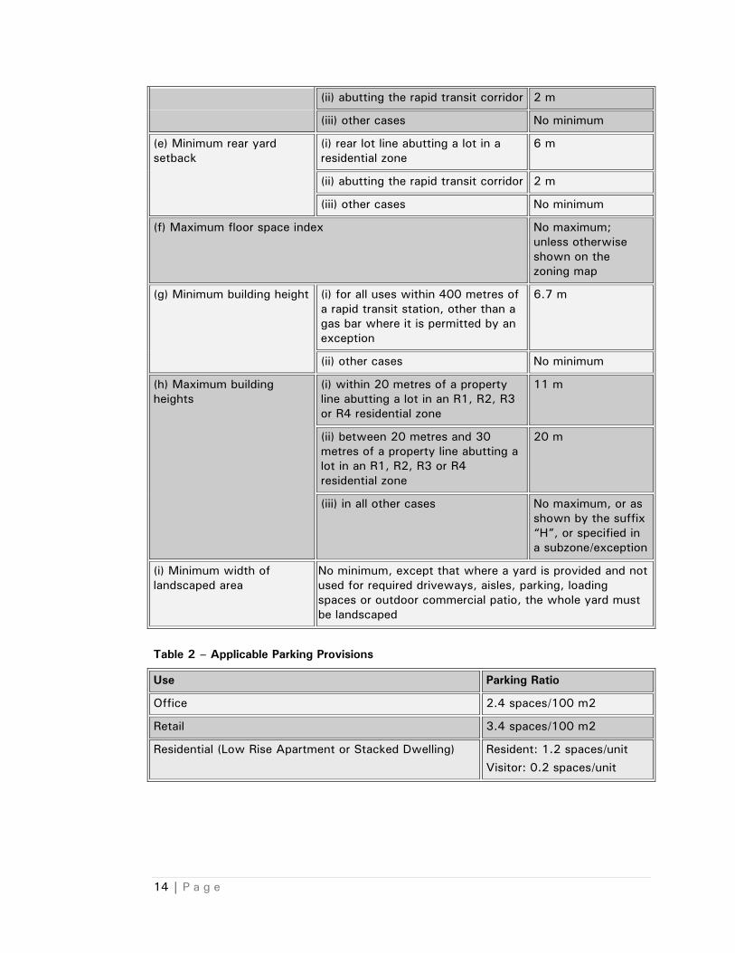
(ii) abutting the rapid transit corridor 2 m
(iii) other cases No minimum
(e) Minimum rear yard setback
(i) rear lot line abutting a lot in a residential zone
6 m
(ii) abutting the rapid transit corridor 2 m
(iii) other cases No minimum
(f) Maximum floor space index No maximum; unless otherwise shown on the zoning map
(g) Minimum building height (i) for all uses within 400 metres of a rapid transit station, other than a gas bar where it is permitted by an exception
6.7 m
(ii) other cases No minimum
(h) Maximum building heights
(i) within 20 metres of a property line abutting a lot in an R1, R2, R3 or R4 residential zone
11 m
(ii) between 20 metres and 30 metres of a property line abutting a lot in an R1, R2, R3 or R4 residential zone
20 m
(iii) in all other cases No maximum, or as shown by the suffix “H”, or specified in a subzone/exception
(i) Minimum width of landscaped area
No minimum, except that where a yard is provided and not used for required driveways, aisles, parking, loading spaces or outdoor commercial patio, the whole yard must be landscaped
Table 2 – Applicable Parking Provisions
Use Parking Ratio
Office 2.4 spaces/100 m2
Retail 3.4 spaces/100 m2
Residential (Low Rise Apartment or Stacked Dwelling) Resident: 1.2 spaces/unit Visitor: 0.2 spaces/unit

15 | P a g e
6. RESPONSE TO THE SITE CONTEXT AND APPLICABLE POLICIES AND REGULATIONS
The Concept Plan for the Minto’s Arcadia commercial lands responds to the vision and intent of the Kanata West Concept Plan while acknowledging the site’s role in transitioning to the low profile residential uses to the north and reflecting Minto’s vision for development. The broad vision for future development on the site that is expressed in the Official Plan’s Mixed-Use Centre designation is re-established based on an area specific perspective in the KWCP. For that reason, this section will rely on the KWCP policies. It is notable that at this stage (re-zoning), fine details such as lighting, landscaping, pedestrian pathways, signage, etc. have not been determined. These details will be provided through the Plan of Subdivision and Site Plan Control process, to the satisfaction of Staff. 6.1. Land Use, Building Siting and Massing
High Profile Employment, Entertainment and Leisure District
• The proposed commercial building and apartment style dwellings are permitted and encouraged in the High Profile District.
• Buildings are located in proximity to the lot lines along Huntmar and Campeau Drive, contributing to the ‘framing’ of the street. In particular, the building at the intersection at Campeau and Huntmar is sited such that it can ‘front’ onto both streets, with equal visibility and access.
• The building heights of 10 to 15 storeys envisioned by the KWCP are not achieved in the proposed Concept Plan; Minto has indicated that the real estate market in Kanata has not yet evolved to the point where that intensity of use could be supported. Nonetheless there are opportunities for the site to evolve and accommodate intensification over time, as follows:
o the commercial block at the intersection of Campeau and Huntmar could accommodate a taller building addition (to the south) where the surface parking lot is proposed, creating a more notable gateway; and
o some of the surface parking areas that accommodate the proposed residential buildings could be redeveloped, if alternative parking arrangements were made possible.
Both opportunities identified above are similar to the intensification approach for the Community Level Retail Lands along Campeau Drive and Hazeldean Road. As applicable policies encourage greater intensity over time, immediate development must respond to market expectations without constraining future development and intensification. The opportunities above address applicable policies by anticipating and protecting for future development on surface parking areas.

16 | P a g e
Of further relevance, the proposed four-storey residential buildings are higher and denser than the residential uses proposed to the north (Minto future Arcadia residential development across Campeau Drive), creating an effective transition. The KWCP applies a dual Residential/Prestige Business Park designation to the Minto Arcadia Residential lands; building heights in the range of 10-15 storeys would be more appropriate if low and medium profile employment uses were planned on those lands.
Intensive Employment Area
• The proposed 3 storey office buildings are both permitted and encouraged in the Intensive Employment Area however they are slightly lower than the target height of 4 – 6 storeys established in the KWCP.
• The buildings are proposed in close proximity to the lot line along Campeau Drive, contributing to “framing” the street.
• Although the surface parking areas are beside (and not behind) the proposed office buildings, it is anticipated that over time, the parking lots may be redeveloped, creating a consistent edge along Campeau Drive. It is also anticipated that future buildings will be in the 4 – 6 storey range envisioned by the Plan.
• The proposed BRT station is within walking distance of the proposed buildings, which will promote transit ridership and reduce the number of employees and visitors using private vehicles.
6.2. Block Pattern
• The proposed road network generally reflects a modified grid pattern, particularly on the north half of the site between the BRT and Campeau Drive. The residential area south of the BRT deviates from the modified grid pattern in response to constraints presented by the flood plain, Feedmill Creek and anticipated roadway connections to adjacent lands.
• Notably, the east-west local road south of the BRT is 100 % single-loaded along the Feedmill Creek Corridor, exceeding the 30 % requirement.
6.3. Parks, Open Space and Streetscape
• As suggested in the design guidelines, parkland is not provided on the site. Instead, pathways within the Feedmill Creek Corridor and common outdoor amenity areas that surround the residential buildings will provide passive recreation space for residents and visitors to the site.
• Pedestrian connections to the south, across Feedmill Creek are provided via sidewalks that will run along Streets 16 and 17.
• Deciduous trees will be planted within the road ROWs, between the paved roadway and buildings, as permitted by the soil conditions.

17 | P a g e
7. THE ENVIRONMENTAL ASSESSMENTS (EAs) The Carp River runs in a north-south direction along the eastern boundary of the Kanata West Concept Plan Area, discharging into the Ottawa River. Due to the impacts of urbanization in its upper reaches, this section of the River has become heavily degraded. Recognition of this condition resulted in the initiation of the Carp River Restoration Plan (CRRP), which commenced with the production of the Carp River Watershed/Subwatershed Study (CRWSS). One of the key recommendations of the CRWSS, approved by Council in 2005, is the establishment of a two-zone floodplain policy which would result in the creation of 28 hectares of developable land from the regulatory (100-year) floodplain in exchange for the rehabilitation of an upper reach of the Carp River. It is intended that this rehabilitation will be largely funded by the Kanata West development proponents. In support of the CRRP, as well as the servicing and transportation needs of the Kanata West development area, a series of Municipal Class Environmental Assessments (Class EAs) were completed with the City of Ottawa and the Kanata West Landowners Group Inc. as co-proponents. The Class EAs and supporting documents include:
• Flow Characterization and Flood Level Analysis: Carp River, Feedmill Creek and Poole Creek (CH2MHill, October 2005);
• Post-Development Flow Characterization and Flood Level Analysis for Carp River, Feedmill Creek and Poole Creek (CH2MHill, June 2006);
• Carp River, Poole Creek and Feedmill Creek Restoration Class Environmental Assessment (Totten Simms Hubicki, June 2006).
• Kanata West Master Servicing Study Volumes 1 and 2 (Stantec, June 2006); and
• Kanata West Transportation Master Plan (Delcan, June 2006).
In July 2006 and August/September 2010, 88 Part II Order requests were received by the Ministry of the Environment from local environmental groups, local community groups and members of the public asking that the City of Ottawa and Kanata West Owners Group (KWOG) be required to prepare an individual environmental assessment (EA) for 7 of the 22 projects listed in the EAs. In a letter dated March 30, 2011 and addressed to Mr. Don Herweyer, Program Manager, Suburban Services Branch, the Minister of the Environment confirmed that an individual EA is not warranted for any of the projects and indicated that the City and KWOG may proceed with the projects, subject to the conditions imposed in the letter.

18 | P a g e
8. KANATA WEST LANDOWNERS In response to the large infrastructure servicing costs and multiple ownerships of the Kanata West lands, the Kanata West Landowners initiated discussions to form and manage a private land owners group. In April 2006, Ottawa City Council approved Official Plan Amendment (OPA) No. 39 to add a policy to the City Council-Approved Official Plan requiring the Kanata West landowners to enter into private agreements to share the costs of the major infrastructure projects and associated studies and plans required for the development of Kanata West. The Kanata West Owners Group Inc. is the association of affected land owners, bound by an agreement in principle to cost share both hard (construction of infrastructure, etc.) and soft (consultants, design review, etc.) costs associated with development in Kanata West. The membership of the Kanata West land owners group currently includes, but is not limited to, Shenkman Corporation and Andridge Capital Corporation, Driveway Realties Limited, Broccolini, Taggart Realty Management and Loblaw Properties Limited, Mattamy Development (Ottawa) Corporation, RONA, Tartan Land Corporation, North American Acquisition Corporation, West Kanata Development Corporation (Minto Development) and Trinity Development Group. The Agreements facilitate the implementation of the major infrastructure projects required for Kanata West. The Kanata West Owners Group Inc. has finalized private cost-sharing agreements that describe the major infrastructure projects required for Kanata West, the estimated cost of each project, and each landowner’s proportionate share of the estimated cost of each project. Costs are to be distributed fairly among the benefiting landowners. In addition to major roadways, water, stormwater and sanitary sewer projects, the Kanata West Concept Plan, the Carp River Watershed/Subwatershed Study, the draft Kanata West Infrastructure Master Servicing Study, and the draft Carp River, Poole Creek and Feedmill Creek Restoration Class Environmental Reports have identified the need for the restoration of the Carp River, Poole Creek and Feedmill Creek. The cost-sharing agreements are intended to include these projects in addition to the projects identified in Ottawa’s 2004 Development Charges Background Study. The agreement between landowners are finalized and in effect, although to various degrees of implementation. The City’s current position, as envisioned by OPA #39, is that Zoning By-law Amendments will not be scheduled for Planning and Environment Committee (PEC) and City Council and that the City will not issue notice of draft subdivision approval or Site Plan Approval if a landowner is not an active member of the Landowners Group and has not participated financially to the terms of the agreement. A letter of “good standing” is required from the group’s trustee, Andrew Orr.

19 | P a g e
9. TECHNICAL STUDIES 9.1. Transportation Impact Study – Delcan, June 2008
The Transportation Impact Study (TIS) focuses specifically on the “Arcadia Subdivision”, which comprises the Minto-owned residential land on the north side of the Campeau Drive Extension and the retail block at the corner of Huntmar and Campeau Drive. The report concludes that the existing and planned transportation network can support the proposed Arcadia Subdivision, with the implementation of specified turning lanes at the following intersections: Huntmar / Campeau; Campeau / on-site collectors; Huntmar / Palladium. Although development on the subject site is not the primary focus of the study, the report does contain high level analysis and findings related to future development on the site. For the purposes of the report, future development on the site was assumed to be 62,245 m2 of office space post 2016. Based on these assumptions, the report concludes that development on the site could be accommodated with improvements such as the implementation of traffic controls and specified turning lanes at the following intersections: Huntmar/Campeau; Campeau/on-site collectors; Huntmar/Palladium. Plans for the site have progressed since the 2008 TIS (the amount of planned office space has decreased however additional retail and residential development is now proposed) and it is acknowledged that the study may need to be updated (particularly for Site Plan Control). However based on the recommendations of the Kanata West Transportation Master Plan (prepared by Delcan in 2006) and the findings cited above, it can be generally concluded that development on the site could be supported by the existing and planned road network, with the implementation of certain roadway improvements. 9.2. Site Servicing Report – IBI Group, November 2010
The Site Servicing Study is tailored to the “Arcadia Subdivision” (immediately north of the site on the other side of the Campeau Drive Extension). The report indicates that water and sanitary services will be extended from Didsbury Road to Huntmar Drive as part of the project. The report identifies source and conveyance controls for stormwater management; it also suggests mitigative measures for controlling erosion and sediment loading. Although the report does not provide analysis or findings related to development on the site, it can be concluded (based on the findings of this report and the Kanata West Master Servicing Study Volumes 1 and 2 prepared by Stantec in 2006), that water and sanitary services will be available to the site from Campeau Drive. It is also assumed that some of the source and conveyance controls and erosion/sediment loading mitigation techniques can and will be applied to future development on the site. It is acknowledged that a Site Servicing Study tailored specifically to development on the site may be necessary to confirm these assumptions (particularly for Site Plan Control) and propose specific servicing recommendations.

20 | P a g e
9.3. Stormwater Management Report – IBI Group, November 2010
A phased approach to stormwater management is recommended for the Arcadia site in the report prepared by IBI Group (November 2010). The interim drainage scheme consists of a single stormwater management facility located to the northeast of the Phase 1 and 2 development area, outside of the 1:100 year flood plain. The Phase 1 and 2 development area can be described as the west-half of the Arcadia Residential lands on the north side of Campeau Drive and the small commercial block at the intersection of Huntmar and Campeau Drive. The permanent drainage scheme, which will accommodate the entire Arcadia site (Residential development north of Campeau Drive and Commercial development south of Campeau Drive), consists of a single stormwater management facility located adjacent to the Carp River, inside the current 1:100 year flood plain boundary. The facility will provide water quality control to MOE Level 2 protection (70% removal of TSS) for the 80.89ha Arcadia development and will discharge into the Carp River. As a result of the March 30, 2011 approval of the EAs by the Minister of the Environment (referenced in more detail on page 17), which set forth a special conditions for stormwater storage, the area and size of the proposed pond will be finalized over the next months. The proposed Concept Plan and Zoning By-law Amendment will contribute valuable information to the stormwater management modelling and calculations.
9.4. Geotechnical Study – Paterson Group, July 2007
The report finds that generally, the subsoil conditions consist of overlying silty clay and glacial till, which, in turn, is underlain by bedrock. The upper portion of the silty clay is a brown weathered crust of stiff consistency. The deeper grey silty clay underlying the surficial crust ranges from soft to stiff in consistency. There are minimum grade raise requirements (identified by IBI Group) on the lower-lying north half of the property as a result of servicing constraints however it is notable that the compressibility of the silty clay materials will impose grade raise restrictions. Where the proposed grade raise is less than the permissible grade raise, it is anticipated that the lighter structures will be founded on shallow footings placed in the upper-weathered crust of the silty clay deposit, whereas heavier structures (e.g. tall commercial buildings) will be founded on bedrock using a deep foundation alternative, such as piles. Where greater than permissible grade raises are proposed, means to reduce the potential long-term post-construction settlements should be implemented, such as pre-loading or surcharging, and/or pile foundations should be used. The report provides specific recommendations for site grading and preparation, foundation design, settlement and grade raise restrictions, foundation options, pavement and design and construction precautions.
21 | P a g e
10. CONCLUSIONS Based on the findings of the Demonstration Report, it is concluded that the proposed development is compatible with existing and planned land uses in the surrounding area, consistent with the policies, goals and objectives of the Official Plan and KWCP and that the Zoning By-law Amendment proposed is appropriate for the future development of the site. Below is a summary of the findings:
• Provides a mix of commercial, residential and employment uses;
• Applies a modified grid road network and reflects the primary north-south road connections (Street 16 and 17) and BRT alignment illustrated in the Demonstration Plan;
• Does not encroach on the boundaries of the Feedmill Creek and Carp River floodplains;
• Proposes heights and densities that are slightly lower than what is envisioned by the KWCP however accommodates opportunities for infill and intensification, once the market demand is present;
• Locates buildings in proximity to the lot lines along Huntmar and Campeau Drive, contributing to the ‘framing’ of the street;
• Accommodates passive recreation with pathways within the Feedmill Creek Corridor and common outdoor amenity areas that surround the residential buildings;
• Anticipates streetscaping in the form of landscaping, sidewalks and pedestrian amenities, which will be identified in detail at the Site Plan and Plan of Subdivision stage; and
• Is capable of being efficiently serviced by planned and existing transportation and servicing infrastructure, subject to confirmation by updated studies.