Embed Size (px)
Citation preview
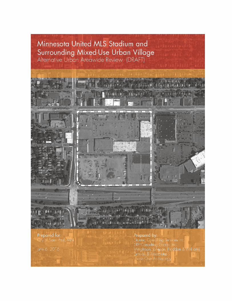
Minnesota United MLS Stadium and Surrounding
Mixed-Use Urban Village
Alternative Urban Areawide Review (AUAR)
DRAFT AUAR
Prepared for the
City of Saint Paul, MN
By
SRF Consulting Group, Inc. Wrightson, Johnson, Haddon & Williams
Braslau & Associates Phase One Archeology
June 6, 2016
MN United Stadium and Mixed-Use Urban Village: Draft AUAR 2016
i
Report Contents
Introduction ....................................................................................................................................................... iv 1. Project Title ............................................................................................................................................. 1 2. Proposers ................................................................................................................................................ 1 3. Responsible Governmental Unit (RGU)............................................................................................. 1 4. Reason for EAW Preparation .............................................................................................................. 1 5. Project Location .................................................................................................................................... 1 6. Project Description ............................................................................................................................... 2 7. Cover types ............................................................................................................................................ 4 8. Permits and approvals required ........................................................................................................ 6 9. Land use ................................................................................................................................................. 8 10. Geology, soils and topography/land forms .............................................................................. 14 11. Water resources .............................................................................................................................. 16 12. Solid Wastes, Hazardous Wastes, Storage Tanks ...................................................................... 23 13. Fish, wildlife, plant communities, and sensitive ecological resources (rare features):...... 26 14. Historic properties ........................................................................................................................... 32 15. Visual ................................................................................................................................................. 34 16. Air ....................................................................................................................................................... 34 17. Noise .................................................................................................................................................. 37 18. Transportation.................................................................................................................................. 47 19. Cumulative potential effects ....................................................................................................... 77
List of Appendices Appendix A Figures Appendix B Cultural Resources Analysis Appendix C Air Quality Analysis Appendix D Stadium Noise Analysis Appendix E Vehicular Noise Analysis Appendix F Transportation Study
MN United Stadium and Mixed-Use Urban Village: Draft AUAR 2016
ii
List of Tables Table 6-1 Scenario 1 Land Use Intensity Table 6-2 Scenario 2 Land Use Intensity Table 7-1 Scenario 1 Pre- and post-construction land cover types Table 7-2 Scenario 2 Pre- and post-construction land cover types Table 8-1 Anticipated Permit Requirements Table 11-1 Minnesota County Well Index Well Records Table 17-1 Field Measurement Summary Table Table 17-2 Field Measurements and Predicted Noise Levels Table 17-3 Minnesota State Noise Standards Table 17-4 Noise Wall Evaluation Results (Daytime) (Southwest Quadrant of AUAR Area) Table 18-1 Level of Service Criteria for Signalized and Unsignalized Intersections Table 18-2 Trip Generation Estimates – Comprehensive Plan/Snelling Station TOD
Development Plan Table 18-3 Trip Generation Estimates – RK Midway Master Plan Development Plan Table 18-4 Year 2035 No Build Intersection Capacity Analysis Table 18-5 Year 2035 Build Intersection Capacity Analysis Table 18-6 Percent of Event Traffic to Arrive/Depart During Peak Hour Table 18-7 Person Trip Generation Estimates – 20,000 Patrons Table 18-8 Year 2018 Weekend Afternoon Event Intersection Capacity Analysis Table 18-9 Transportation Analysis Results – LRT/BRT Table 18-10 Transportation Analysis Results – Shuttle Bus Table 18-11 Person Trip Generation Estimates – 25,500 Patrons Table 18-12 Year 2035 Weekend Afternoon Event Intersection Capacity Analysis
MN United Stadium and Mixed-Use Urban Village: Draft AUAR 2016
iii
List of Figures (Appendix A) Figure 5-1 USGS Location Map Figure 5-2 AUAR Area Boundary Figure 6-1 Scenario 1 Site Plan and Program Figure 6-2 Scenario 2 Site Plan Figure 6-3 Scenario 2 Program Figure 6-4 Scenario 2 Program with Building Heights Figure 7-1 Existing Land Cover Figure 7-2 Scenario 1 Post-Construction Land Cover Figure 7-3 Scenario 2 Post-Construction Land Cover Figure 9-1 Existing Land Use Figure 9-2 Future Land Use Figure 9-3 Existing Zoning Figure 10-1 Soils and Topography Figure 11-1 Wells within the AUAR Area Figure 15-1 Scenario 2 Stadium Lighting Direction Figure 17-1 Stadium Noise Figure 17-2 Stadium Sound System Noise Contours Figure 17-3 Traffic Noise Figure 18-1 Project Location Figure 18-2 Data Collection Locations Figure 18-3 Master Plan Figure 18-4 Event Distribution Figure 18-5 Year of Opening On-Site Parking Figure 18-6 Year of Opening Pedestrian Routing Figure 18-7 Year of Opening Stadium Event Access Figure 18-8 Year 2035 Stadium Event Pedestrian Routing
MN United Stadium and Mixed-Use Urban Village: Draft AUAR 2016
iv
Introduction This Environmental Assessment Worksheet (EAW) form is being used to record the Alternative Urban Areawide Review (AUAR) for a stadium and mixed-use development in Saint Paul, MN. An AUAR is an alternative to an Environmental Impact Statement (EIS) that responds to the questions on the EAW form to the level of analysis similar to an EIS. This EAW form and AUAR Guidelines are available at the Environmental Quality Board’s website at: http://www.eqb.state.mn.us/EnvRevGuidanceDocuments.htm. Minnesota Rules Chapter 4410.3610, subp. 4 states that “the content and format [of an AUAR document] must be similar to that of an EAW, but must provide for a level of analysis comparable to that of an EIS for impacts typical of urban residential, commercial warehousing, and light industrial development and associated infrastructure.” The EAW and AUAR Guidelines provide additional details and resources for completing the EAW form for an AUAR and conducting the AUAR review process. The following document follows the format of the July 2013 Environmental Assessment Worksheet Form. Note to reviewers: Comments must be submitted to the RGU during the 30-day comment period following notice of the document in the EQB Monitor.
MN United Stadium and Mixed-Use Urban Village: Draft AUAR 2016
1
1. Project Title Minnesota United MLS Stadium and Surrounding Mixed-Use Urban Village
2. Proposers MUSC Holdings, LLC and RK Midway, LLC Contact person William McGuire Title Chief Manager Address 90 S. 7th Street, Suite 5500 City, State, Zip Minneapolis, MN 55402 Phone 612.270.3943 E-mail [email protected]
3. Responsible Governmental Unit (RGU) City of Saint Paul Contact Person Josh Williams Title Senior Planner Address 25 W. 4th Street City, State, ZIP St. Paul, MN 55102 Phone 651.266.6659 Fax 651.266.6549 E-mail [email protected]
4. Reason for EAW Preparation Not applicable to an AUAR. Minnesota Rules Chapter 4410.3610 Subpart 5a requires additional procedures when certain large specific projects are reviewed. Minnesota Rules Chapter 4410.4300 Subpart 34 pertains to this project: Sports or entertainment facilities. The Scoping Environmental Assessment Worksheet (EAW) published February 22, 2016 was prepared as a scoping document to guide this AUAR.
5. Project Location
County Ramsey City Saint Paul PLS Location: NWSW342923 (NW ¼ of SW ¼ of Section 34 of Township 29N Range 23W) Watershed: Mississippi River Twin Cities (07010206), Capitol Region Watershed District GPS Coordinates: Approx. center of site is Latitude 44.98382 degrees North, Longitude 93.16400 degrees West Tax Parcel Number: 342923320001, 342923320003, 342923320005, 342923320006, 342923320008, 342923320009, 342923320010
Attach each of the following maps to the EAW: county map, USGS map, and a site plan. AUAR Guidelines: The county map is not needed for an AUAR. The USGS map should be included. Instead of a site plan, include: (1) a map clearly depicting the boundaries of the AUAR and any subdistricts used in the AUAR analysis; (2) land use and planning maps as required in conjunction with items 9 and 27; and (3) a cover type map as required for item 10. Additional maps may be included throughout the document wherever maps are useful for displaying relevant information.
All required maps and additional figures displaying relevant information are found in Appendix A.

MN United Stadium and Mixed-Use Urban Village: Draft AUAR 2016
2
6. Project Description
a. Provide the brief project summary to be published in the EQB Monitor. MUSC Holdings LLC (one of the Proposers) proposes to build a 20,000 seat professional soccer stadium with expansion and standing room capacity to accommodate a maximum of 25,500 visitors (plus 500 employees) in Saint Paul, MN. The AUAR area is bounded by University Avenue to the north, Snelling Avenue to the west, Pascal Street to the east, and St. Anthony Avenue to the south. Following stadium development, the remainder of the AUAR area will be redeveloped in a phased manner to accommodate mixed-use development including retail and service commercial, hospitality, residential, office, institutional uses and public and private open space. RK Midway (one of the Proposers) owns the remainder of the AUAR area.
b. Give a complete description of the proposed project and related new construction,
including infrastructure needs. If the project is an expansion include a description of the existing facility. Emphasize: 1) construction, operation methods and features that will cause physical manipulation of the environment or will produce wastes, 2) modifications to existing equipment or industrial processes, 3) significant demolition, removal or remodeling of existing structures, and 4) timing and duration of construction activities. MUSC Holdings LLC (one of the Proposers) proposes to build a 20,000 seat stadium with expansion and standing room capacity to accommodate a maximum of 25,500 visitors (with 500 employees) in the AUAR area. The site will be used primarily as the home stadium for Minnesota United to host professional soccer games. The stadium will also potentially be used for college, high school and youth soccer games and other music and entertainment events. The remainder of the AUAR area, owned by RK Midway, LLC (one of the Proposers), will be redeveloped in a phased manner to accommodate a mixed-use development including retail and service commercial, hospitality, residential, office, institutional uses and public and private open space. Redevelopment of the AUAR area will likely result in the creation of a street grid internal to the AUAR area, new or upgraded utilities to serve the AUAR area, and potential limited improvements to infrastructure in the immediate vicinity of the AUAR area.
1) Typical urban development methods will be used and all wastes from construction will be reused or disposed of according to all applicable city, state, and federal regulations.
2) There will be no modifications to existing equipment or industrial processes. Any and all existing equipment will be removed from the site and disposed of according to all applicable city, state and federal regulations.
3) Over a period of time to be determined by market demand, existing structures will be demolished and replaced by new structures on the project site. All construction wastes will be removed and disposed of off-site according to all applicable city, state and federal regulations.
4) At this time, redevelopment of the AUAR area is estimated to be accomplished in multiple phases over ten to fifteen years or longer, depending on market conditions.
MN United Stadium and Mixed-Use Urban Village: Draft AUAR 2016
3
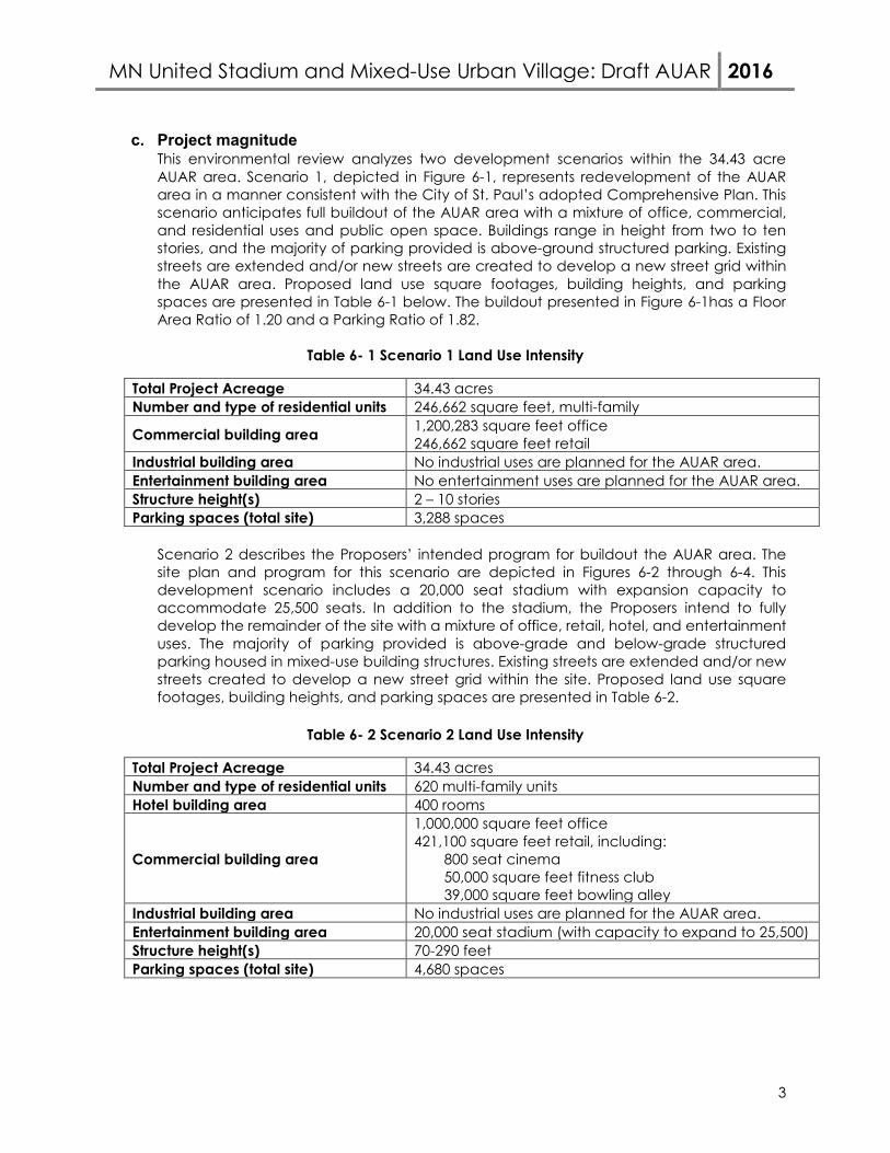
c. Project magnitude This environmental review analyzes two development scenarios within the 34.43 acre AUAR area. Scenario 1, depicted in Figure 6-1, represents redevelopment of the AUAR area in a manner consistent with the City of St. Paul’s adopted Comprehensive Plan. This scenario anticipates full buildout of the AUAR area with a mixture of office, commercial, and residential uses and public open space. Buildings range in height from two to ten stories, and the majority of parking provided is above-ground structured parking. Existing streets are extended and/or new streets are created to develop a new street grid within the AUAR area. Proposed land use square footages, building heights, and parking spaces are presented in Table 6-1 below. The buildout presented in Figure 6-1has a Floor Area Ratio of 1.20 and a Parking Ratio of 1.82.
Table 6- 1 Scenario 1 Land Use Intensity
Total Project Acreage 34.43 acres Number and type of residential units 246,662 square feet, multi-family
Commercial building area 1,200,283 square feet office 246,662 square feet retail
Industrial building area No industrial uses are planned for the AUAR area. Entertainment building area No entertainment uses are planned for the AUAR area. Structure height(s) 2 – 10 stories Parking spaces (total site) 3,288 spaces
Scenario 2 describes the Proposers’ intended program for buildout the AUAR area. The site plan and program for this scenario are depicted in Figures 6-2 through 6-4. This development scenario includes a 20,000 seat stadium with expansion capacity to accommodate 25,500 seats. In addition to the stadium, the Proposers intend to fully develop the remainder of the site with a mixture of office, retail, hotel, and entertainment uses. The majority of parking provided is above-grade and below-grade structured parking housed in mixed-use building structures. Existing streets are extended and/or new streets created to develop a new street grid within the site. Proposed land use square footages, building heights, and parking spaces are presented in Table 6-2.
Table 6- 2 Scenario 2 Land Use Intensity
Total Project Acreage 34.43 acres Number and type of residential units 620 multi-family units Hotel building area 400 rooms
Commercial building area
1,000,000 square feet office 421,100 square feet retail, including:
800 seat cinema 50,000 square feet fitness club 39,000 square feet bowling alley
Industrial building area No industrial uses are planned for the AUAR area. Entertainment building area 20,000 seat stadium (with capacity to expand to 25,500) Structure height(s) 70-290 feet Parking spaces (total site) 4,680 spaces
MN United Stadium and Mixed-Use Urban Village: Draft AUAR 2016
4
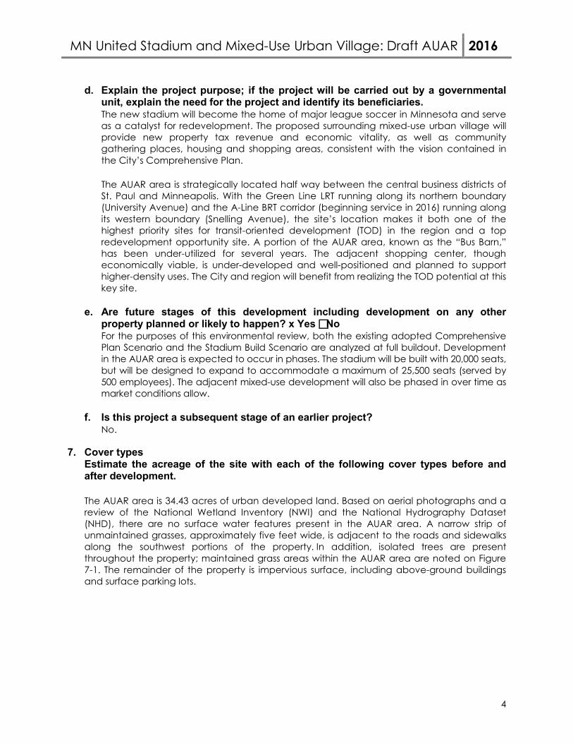
d. Explain the project purpose; if the project will be carried out by a governmental unit, explain the need for the project and identify its beneficiaries. The new stadium will become the home of major league soccer in Minnesota and serve as a catalyst for redevelopment. The proposed surrounding mixed-use urban village will provide new property tax revenue and economic vitality, as well as community gathering places, housing and shopping areas, consistent with the vision contained in the City’s Comprehensive Plan. The AUAR area is strategically located half way between the central business districts of St. Paul and Minneapolis. With the Green Line LRT running along its northern boundary (University Avenue) and the A-Line BRT corridor (beginning service in 2016) running along its western boundary (Snelling Avenue), the site’s location makes it both one of the highest priority sites for transit-oriented development (TOD) in the region and a top redevelopment opportunity site. A portion of the AUAR area, known as the “Bus Barn,” has been under-utilized for several years. The adjacent shopping center, though economically viable, is under-developed and well-positioned and planned to support higher-density uses. The City and region will benefit from realizing the TOD potential at this key site.
e. Are future stages of this development including development on any other property planned or likely to happen? x Yes No For the purposes of this environmental review, both the existing adopted Comprehensive Plan Scenario and the Stadium Build Scenario are analyzed at full buildout. Development in the AUAR area is expected to occur in phases. The stadium will be built with 20,000 seats, but will be designed to expand to accommodate a maximum of 25,500 seats (served by 500 employees). The adjacent mixed-use development will also be phased in over time as market conditions allow.
f. Is this project a subsequent stage of an earlier project?
No.
7. Cover types Estimate the acreage of the site with each of the following cover types before and after development.
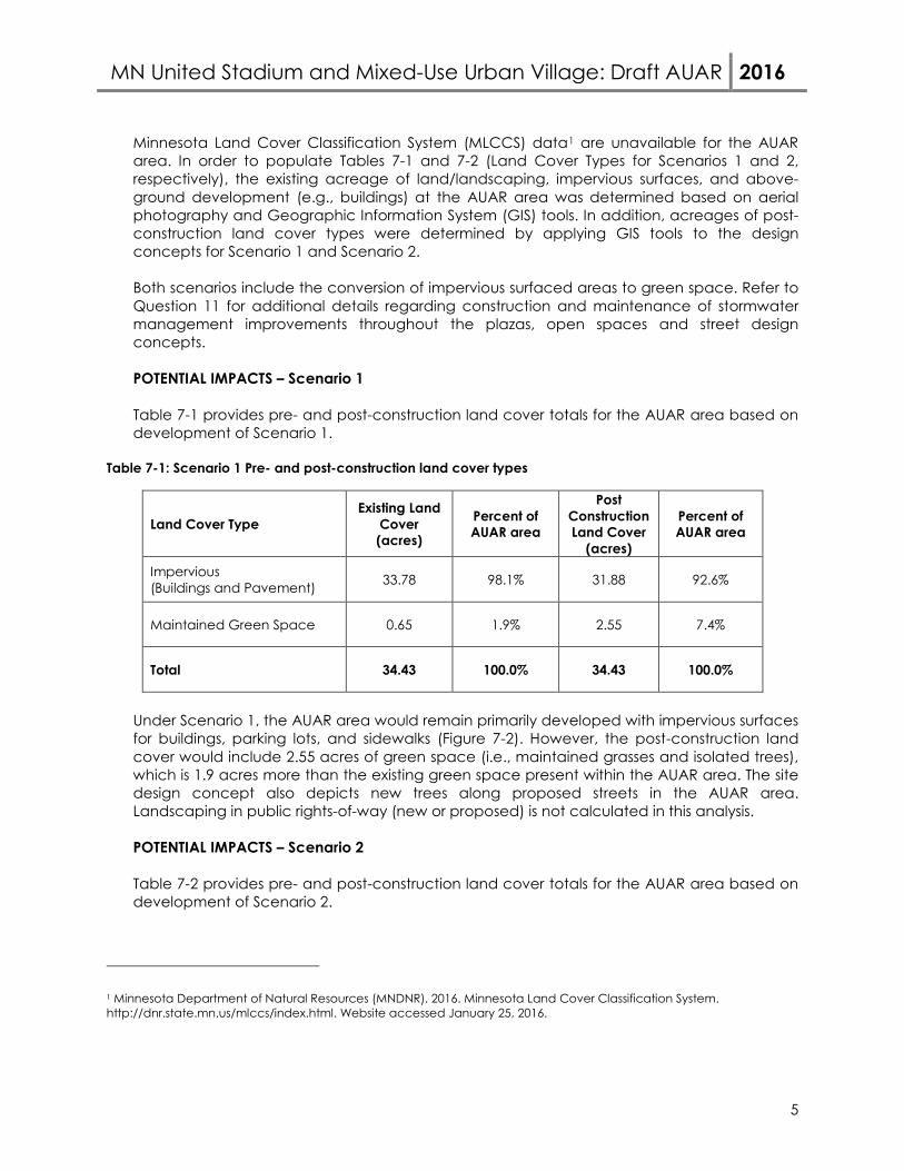
The AUAR area is 34.43 acres of urban developed land. Based on aerial photographs and a review of the National Wetland Inventory (NWI) and the National Hydrography Dataset (NHD), there are no surface water features present in the AUAR area. A narrow strip of unmaintained grasses, approximately five feet wide, is adjacent to the roads and sidewalks along the southwest portions of the property. In addition, isolated trees are present throughout the property; maintained grass areas within the AUAR area are noted on Figure 7-1. The remainder of the property is impervious surface, including above-ground buildings and surface parking lots.
MN United Stadium and Mixed-Use Urban Village: Draft AUAR 2016
5
Minnesota Land Cover Classification System (MLCCS) data1 are unavailable for the AUAR area. In order to populate Tables 7-1 and 7-2 (Land Cover Types for Scenarios 1 and 2, respectively), the existing acreage of land/landscaping, impervious surfaces, and above-ground development (e.g., buildings) at the AUAR area was determined based on aerial photography and Geographic Information System (GIS) tools. In addition, acreages of post-construction land cover types were determined by applying GIS tools to the design concepts for Scenario 1 and Scenario 2.
Both scenarios include the conversion of impervious surfaced areas to green space. Refer to Question 11 for additional details regarding construction and maintenance of stormwater management improvements throughout the plazas, open spaces and street design concepts. POTENTIAL IMPACTS – Scenario 1 Table 7-1 provides pre- and post-construction land cover totals for the AUAR area based on development of Scenario 1.
Table 7-1: Scenario 1 Pre- and post-construction land cover types
Land Cover Type Existing Land
Cover (acres)
Percent of AUAR area
Post Construction Land Cover
(acres)
Percent of AUAR area
Impervious (Buildings and Pavement) 33.78 98.1% 31.88 92.6%
Maintained Green Space 0.65 1.9% 2.55 7.4%
Total 34.43 100.0% 34.43 100.0%
Under Scenario 1, the AUAR area would remain primarily developed with impervious surfaces for buildings, parking lots, and sidewalks (Figure 7-2). However, the post-construction land cover would include 2.55 acres of green space (i.e., maintained grasses and isolated trees), which is 1.9 acres more than the existing green space present within the AUAR area. The site design concept also depicts new trees along proposed streets in the AUAR area. Landscaping in public rights-of-way (new or proposed) is not calculated in this analysis. POTENTIAL IMPACTS – Scenario 2 Table 7-2 provides pre- and post-construction land cover totals for the AUAR area based on development of Scenario 2.
1 Minnesota Department of Natural Resources (MNDNR). 2016. Minnesota Land Cover Classification System. http://dnr.state.mn.us/mlccs/index.html. Website accessed January 25, 2016.
MN United Stadium and Mixed-Use Urban Village: Draft AUAR 2016
6
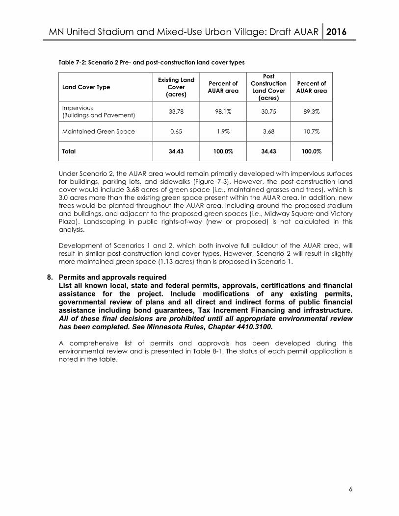
Table 7-2: Scenario 2 Pre- and post-construction land cover types
Land Cover Type Existing Land
Cover (acres)
Percent of AUAR area
Post Construction Land Cover
(acres)
Percent of AUAR area
Impervious (Buildings and Pavement) 33.78 98.1% 30.75 89.3%
Maintained Green Space 0.65 1.9% 3.68 10.7%
Total 34.43 100.0% 34.43 100.0%
Under Scenario 2, the AUAR area would remain primarily developed with impervious surfaces for buildings, parking lots, and sidewalks (Figure 7-3). However, the post-construction land cover would include 3.68 acres of green space (i.e., maintained grasses and trees), which is 3.0 acres more than the existing green space present within the AUAR area. In addition, new trees would be planted throughout the AUAR area, including around the proposed stadium and buildings, and adjacent to the proposed green spaces (i.e., Midway Square and Victory Plaza). Landscaping in public rights-of-way (new or proposed) is not calculated in this analysis. Development of Scenarios 1 and 2, which both involve full buildout of the AUAR area, will result in similar post-construction land cover types. However, Scenario 2 will result in slightly more maintained green space (1.13 acres) than is proposed in Scenario 1.
8. Permits and approvals required List all known local, state and federal permits, approvals, certifications and financial assistance for the project. Include modifications of any existing permits, governmental review of plans and all direct and indirect forms of public financial assistance including bond guarantees, Tax Increment Financing and infrastructure. All of these final decisions are prohibited until all appropriate environmental review has been completed. See Minnesota Rules, Chapter 4410.3100.
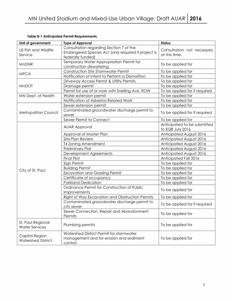
A comprehensive list of permits and approvals has been developed during this environmental review and is presented in Table 8-1. The status of each permit application is noted in the table.
MN United Stadium and Mixed-Use Urban Village: Draft AUAR 2016
7
Table 8-1 Anticipated Permit Requirements
Unit of government Type of Approval Status
US Fish and Wildlife Service
Consultation regarding Section 7 of the Endangered Species Act (only required if project is federally funded)
Consultation not necessary at this time.
MnDNR Temporary Water Appropriation Permit for construction dewatering To be applied for
MPCA Construction Site Stormwater Permit To be applied for Notification of Intent to Perform a Demolition To be applied for
MnDOT Driveway Access Permit & Utility Permits To be applied for Drainage permit To be applied for Permit for use of or work with Snelling Ave. ROW To be applied for if required
MN Dept. of Health
Water extension permit To be applied for Notification of Asbestos Related Work To be applied for
Metropolitan Council
Sewer extension permit To be applied for Contaminated groundwater discharge permit to sewer To be applied for if required
Sewer Permit to Connect To be applied for
City of St. Paul
AUAR Approval Anticipated to be submitted to EQB July 2016
Approval of Master Plan Anticipated August 2016 Site Plan Review Anticipated August 2016 T4 Zoning Amendment Anticipated August 2016 Preliminary Plat Anticipated August 2016 Development Agreements Anticipated August 2016 Final Plat Anticipated Fall 2016 Sign Permit To be applied for Building Permit To be applied for Excavation and Grading Permit To be applied for Certificate of occupancy To be applied for Parkland Dedication To be applied for Ordinance Permit for Construction of Public Improvements To be applied for
Right of Way Excavation and Obstruction Permits To be applied for Contaminated groundwater discharge permit to city sewer To be applied for if required
Sewer Connection, Repair and Abandonment Permits To be applied for
St. Paul Regional Water Services Plumbing permits To be applied for
Capitol Region Watershed District
Watershed District Permit for stormwater management and for erosion and sediment control
To be applied for
MN United Stadium and Mixed-Use Urban Village: Draft AUAR 2016
8
9. Land use a. Describe:
i. Existing land use of the site as well as areas adjacent to and near the site, including parks, trails, prime or unique farmlands.
The AUAR area is currently home to the Midway Shopping Center and a vacant parcel formerly used as the Metro Transit Bus Barn facility (demolished in 2001), for bus storage, and for staging during construction of the Green Line. The shopping center, considered a mixed commercial use, occupies the northern portion of the AUAR area and the former bus barn property occupies most of the southern portion of the AUAR area. A five-acre parcel with some surface parking, located immediately east of the former bus barn property, is also owned by the shopping center owners. The AUAR area is bordered by two major arterial roads, Snelling Avenue and University Avenue. Both are lined with other commercial and office uses. The southern side of the AUAR area is bordered by St. Anthony Ave., a westbound frontage road to Interstate 94. As depicted in Figure 9-1, commercial uses line Snelling and University Avenues opposite the AUAR area, giving way to mixed single- and multi-family residential neighborhoods beyond. The neighborhood to the south across St. Anthony Avenue, Interstate 94, and Concordia Avenue (the eastbound frontage road to Interstate 94) is primarily mixed residential with some commercial. A large shopping center is immediately east of the AUAR area along Pascal Street. The nearest park to the AUAR area is Hamline Park, located approximately one quarter mile north on Snelling Avenue and Thomas Avenue. The park features a playground, open space, and tennis and basketball courts. No scenic or recreational trails exist near the AUAR area. However, there is a separated lane bicycle facility along Pascal Street between Concordia Ave. and University Ave., which transitions to a shared lane facility north of University Ave. and south of Concordia Ave. Charles Avenue, two blocks north of the AUAR area, is a designated bicycle boulevard (a shared-lane facility). The Saint Paul Bicycle Plan, adopted in 2015, also calls for a separated bicycle lane bisecting the AUAR area in approximate alignment with Shields Avenue, which currently terminates at Snelling Avenue at the western edge of the AUAR area. The Plan also identifies additional improvements to the existing bikeway on Pascal Street, as well as new bikeways to be developed around the AUAR area on Shields Avenue, Aldine Street, Saint Anthony Avenue, and Hamline Avenue. There are no unique or prime farmlands within the AUAR area or nearby.
ii. Plans. Describe planned land use as identified in comprehensive plan (if
available) and any other applicable plan for land use, water, or resources management by a local, regional, state, or federal agency.
Comprehensive Plan: The City of Saint Paul’s 2010 Comprehensive Plan is divided into seven chapters, each addressing different policy areas. The land use chapter of the Plan includes a future land use map which identifies future land use character areas, including density ranges, for the entire city. Figure 9-2 depicts the City of Saint Paul’s Future Land Use guidance for the AUAR area.
MN United Stadium and Mixed-Use Urban Village: Draft AUAR 2016
9
The Plan identifies the AUAR area and the adjacent University and Snelling Avenue corridors as Mixed-Use Corridors and identifies the area around the intersection of Snelling and University Avenue as a Neighborhood Center. The Plan identifies these land use character areas as appropriate for a broad mix of uses at the highest densities allowed outside of the downtown core. Policies in the Plan call for these areas to accommodate growth, support transit use and walking, and provide diverse housing options a mix of commercial uses that support transit. The Metro Transit Bus Barn property, in the southern part of the AUAR area, is also identified in the Plan as an Opportunity Site for future redevelopment for mixed-use or as an employment center. Snelling Station Area Plan: Prior to the construction of the Green Line along University Avenue, the City of Saint Paul developed the Snelling Station Area Plan (SAP), which was adopted as an addendum to the Comprehensive Plan. The vision for the area includes future development that is mixed-use, walkable, sustainable, provides new open spaces, increases transit ridership, and serves as an economic catalyst. Development should be dense, with four to six story building heights and point towers up to fifteen stories. In regard to the AUAR area, the SAP calls for a land use strategy that focuses on connectivity, design, and transit and for increasing development intensity in the area. The SAP also recommends these blocks be transformed into a “new urban village” and a transit-oriented development demonstration site. The SAP generally indicates that entertainment-related uses are best located in the southern portion of the AUAR area and specifically identifies entertainment uses as a desired potential use for the bus barn property (p. 27, Policy 4.1.2 e). Other relevant water and natural resources plans will be discussed in the response to the topic most closely related to the plan document.
iii. Zoning, including special districts or overlays such as shoreland, floodplain,
wild and scenic rivers, critical area, agricultural preserves, etc.
The AUAR area is currently zoned T4 Traditional Neighborhood. There are no overlay districts in the AUAR area. Figure 9-3 depicts the City of Saint Paul’s adopted zoning districts in and around the AUAR area. According to the City of Saint Paul’s zoning code, “traditional neighborhood districts are intended to foster the development and growth of compact, pedestrian-oriented urban villages.” There are four traditional neighborhood districts, each ranging in intensity and size. T4 is the most intense district and allows for high density development, focused on major transit nodes. Principal uses in the district include multi-family residential, commercial, institutional, office, and retail. There are numerous design standards in the district that encourage a traditional urban character and diversity of uses. A full list of requirements for the district can be found in the City of Saint Paul’s Zoning Code §3.66.300. Currently, the T4 zoning district allows entertainment uses, but does not specify any particular entertainment uses that are allowed or prohibited in the district. The City of Saint Paul believes that outdoor sports and entertainment venues are
MN United Stadium and Mixed-Use Urban Village: Draft AUAR 2016
10
appropriate uses in T4 zoning district when they are uniquely served by transportation access and proximity to a fixed rail station. The City intends to update its zoning code to allow outdoor sports and entertainment uses in the T4 district. This will provide additional clarification on what is an allowed entertainment use in the district. The public hearing before the City Council on the amendment to the code is anticipated to occur in August 2016. Zoning Compatibility Scenario 1 The mix of commercial, residential, open space, and institutional uses identified in Scenario 1 are permitted in the T4 zoning district. Scenario 2 The mix of commercial, residential, open space, and institutional uses identified in Scenario 2 are permitted in the T4 zoning district. As noted in question 9a, the T4 zoning district allows entertainment uses. The City of Saint Paul interprets stadiums to be an entertainment use. However, because of the unique scale of stadiums, the City intends to amend its zoning code to allow outdoor sports and entertainment uses in the T4 district. This process is anticipated to be completed in the summer of 2016.
b. Discuss the project’s compatibility with nearby land uses, zoning, and plans listed
in Item 9a above, concentrating on implications for environmental effects.
Nearby Land Use Compatibility Both Scenario 1 and Scenario 2 propose a mix of uses that complement the surrounding neighborhood and are positioned to take advantage of the numerous transit opportunities contiguous to the AUAR area. Each scenario’s compatibility with surrounding land uses is listed below. Scenario 1 Scenario 1 reflects the goals of the City of Saint Paul Comprehensive Plan which emphasizes a mix of uses that support dense development and transit ridership. The proposed uses are aligned with these goals and the general character of the neighborhood. Parks: Scenario 1 proposes the addition of approximately two acres of open space. This will greatly benefit new and existing residents, as there is currently no open space in the AUAR area and the nearest park is located one quarter mile north of the AUAR area along Snelling Avenue.
Residential and Mixed-Use Residential: Scenario 1 proposes the addition of high density residential uses. Residential uses are consistent with the surrounding neighborhood. Similarly-scaled new multi-family housing continues to be developed along University Avenue, such as the recently-constructed Hamline Station Apartments at University Avenue and Hamline Avenue and the Episcopal Homes expansion at University Avenue and Fairview Avenue. Nearby residential neighborhoods tend to be comprised of an array of single and multi-family housing options. New multi-family residential uses will create additional housing types and styles in the neighborhood.
MN United Stadium and Mixed-Use Urban Village: Draft AUAR 2016
11
Commercial: Scenario 1 proposes commercial uses. The University Avenue Corridor is a major commercial corridor throughout the City and current land use in the AUAR area is predominantly retail. Proposed commercial uses are consistent with current uses in the AUAR area and on neighboring properties.
Office: Scenario 1 proposes the development of mixed office spaces characteristic of many properties along University Avenue, including the Spruce Tree Centre immediately adjacent to the AUAR area. Scenario 2 Scenario 2 is the Stadium Build scenario, featuring a mix of commercial, residential and entertainment uses surrounding a 20,000 seat stadium located in the southern portion of the AUAR area. The proposed uses are aligned with the general character of the neighborhood. Parks: Scenario 2 proposes the addition of approximately three acres of open space. This will greatly benefit new and existing residents, as there is currently no open space in the AUAR area and the nearest park is located one quarter mile north of the AUAR area along Snelling Avenue.
Residential and Mixed-Use Residential: Scenario 2 proposes the addition of high density residential uses. Residential uses are consistent with the surrounding neighborhood. Similarly-scaled new multi-family housing continues to be developed along University Avenue, such as the recently-constructed Hamline Station Apartments at University Avenue and Hamline Avenue and the Episcopal Homes expansion at University Avenue and Fairview Avenue. Nearby residential neighborhoods are typically comprised of an array of single and multi-family housing options. New multi-family residential uses will create additional housing types and styles in the neighborhood. Commercial: Scenario 2 proposes commercial uses. The University Avenue Corridor is a major commercial corridor throughout the City and current land use in the AUAR area is predominantly retail. Proposed commercial uses are consistent with current uses in the AUAR area and on neighboring properties. Office Space: Scenario 2 proposes the development of mixed-use office spaces, characteristic of many properties along University Avenue, including the Spruce Tree Centre immediately adjacent to the AUAR area. Entertainment: Scenario 2 proposes the construction of a movie theater and bowling alley. Currently, a bowling alley operates in the Midway Shopping Center. These entertainment opportunities will provide additional entertainment venues for present and future residents of the area.
Hotel: A hotel is proposed as part of Scenario 2. While there are not currently any hotel uses in the AUAR area or its immediate vicinity, it is consistent with other multi-family residential and entertainment uses in the area. New hotels across the Twin Cities region have been and are being built in urban areas outside the downtown core, such as the Midtown Sheraton in Minneapolis. These properties have brought additional customers to support nearby entertainment and commercial uses.
MN United Stadium and Mixed-Use Urban Village: Draft AUAR 2016
12
Stadium: Scenario 2 proposes the construction of a professional soccer stadium in the southern part of the AUAR area. While there are other small scale entertainment uses in the neighborhood, such as bars, restaurants, and a bowling alley, there are no entertainment venues of this scale currently present in the AUAR area. An open-air, multi-sport stadium with approximately 3,500-seats (with an inflatable dome for winter use) is located at Concordia University, southeast of the AUAR area across Interstate 94.
Nearby Zoning Compatibility As noted above, the AUAR area is located in the T4 zoning district. The property immediately to the east of the AUAR area is also zoned T4. To the north and east of the site, the University and Snelling Avenue commercial corridors are zoned T2, T3, and T4. Like T4, these districts support a mix of neighborhood-scale retail, office, commercial, and residential uses. Residential neighborhoods to the north and east of the AUAR area are zoned to allow multi-family residential uses. Residential neighborhoods south of the AUAR area and separated by I-94 are zoned RT1 Two-Family Residential. Scenario 1 The mix of commercial, residential, open space, and institutional uses identified in Scenario 1 are compatible with the zoning districts nearby. Existing residential zones are buffered by existing commercial zones on the north and east and Interstate 94 on the south. Scenario 1 does propose more intensive development than is currently within the AUAR area, which may have traffic impacts for surrounding areas. These impacts are discussed further in Question 18. Scenario 2 The mix of commercial, residential, open space, and institutional uses identified in Scenario 2 are compatible with the zoning districts nearby. Existing residential zones are buffered by existing commercial zones on the north and east and Interstate 94 on the south. This environmental review analyzes the potential impacts of increased noise, lights and traffic from the proposed stadium on surrounding neighborhoods. Analysis of these potential impacts and appropriate mitigation measures to avoid negative impacts are discussed further in Questions 15, 17, and 18 respectively. Relevant Plans There are two plans that are particularly relevant to the AUAR area: the 2010 Comprehensive Plan and the Snelling Station Area Plan. The two scenarios and their consistency with these plans are discussed below. 2010 Comprehensive Plan The City of Saint Paul’s 2010 Comprehensive Plan identifies the importance of the Snelling-University intersection as a major redevelopment opportunity. The Plan calls for a mix of uses including office and retail space to generate economic growth. Scenario 1 As described above, Scenario 1 features a mix of high density residential, office and commercial uses. Retail and office uses would generate new economic opportunities and encourage use of transit by creating destinations in close proximity to Snelling and University Ave transit stations. Residential uses will generate ridership for nearby transit facilities.
MN United Stadium and Mixed-Use Urban Village: Draft AUAR 2016
13
Scenario 2 As described above, Scenario 2 features a mix of high density residential, commercial, office, and entertainment uses as well as the Minnesota United soccer stadium. Retail and office uses would generate new economic opportunities and encourage use of transit by creating destinations in close proximity to Snelling and University Ave transit stations. Residential uses will generate ridership for nearby transit facilities. Snelling Avenue Station Area Plan In anticipation of Green Line LRT construction, the City of Saint Paul developed a series of station area plans. The Snelling Station Area Plan called for walkability, access to transit, density, and increased greenspace. The plan identified the Metro Transit Bus Barn site (at the southwest corner of the AUAR area) as a potential location for an entertainment-related use. Scenario 1 The mixed-use, high density development proposed in Scenario 1 is compatible with the Station Area Plan. New housing, employment opportunities, and increased green space meet the plan’s goals. However, this scenario does not include large-scale entertainment uses on the Metro Transit Bus Barn site. Scenario 2 The mixed-use, high density development proposed in Scenario 2 is compatible with the Station Area Plan. New housing, employment opportunities, and increased green space meet the plan’s goals. Additionally, the soccer stadium, located at the southern end of the AUAR area, will serve as a major entertainment use, as suggested by the Plan.
c. Identify measures incorporated into the proposed project to mitigate any potential
incompatibility as discussed in Item 9b above.
Parkland: Both scenarios increase parkland and open space for the community. No mitigation strategies are needed. Proposed Commercial and Residential Uses: The proposed mix of commercial and residential uses is consistent with surrounding land uses. Question 18 describes mitigation strategies to address additional traffic caused by commercial and residential development of the AUAR area anticipated with both Scenario 1 and Scenario 2. Nearby Residential Neighborhoods: The proposed stadium in Scenario 2 has potential impacts for surrounding residential neighborhoods related to event noise, glare from stadium lights, and increased traffic. Questions 15, 17, and 18 identify mitigation strategies related to these impacts. Zoning: Both scenarios present a mix of uses that are consistent with the T4 zoning district. While other neighborhood residential uses are nearby, they are buffered by other T4 and T2 commercial, mixed-use zones. Additionally, the City of Saint Paul intends to amend its zoning code to allow outdoor sports and entertainment uses. Even without this additional clarification, both scenarios include uses that are permitted in the code and no mitigation strategies are needed.
MN United Stadium and Mixed-Use Urban Village: Draft AUAR 2016
14
10. Geology, soils and topography/land forms a. Geology - Describe the geology underlying the project area and identify and map
any susceptible geologic features such as sinkholes, shallow limestone formations, unconfined/shallow aquifers, or karst conditions. Discuss any limitations of these features for the project and any effects the project could have on these features. Identify any project designs or mitigation measures to address effects to geologic features.
The following sources were consulted for this section: Ramsey County Geologic Atlas, MN Well Index, the Minnesota County Well Index, and the 2015 Braun Intertec Environmental and Geotechnical Review. The AUAR area is underlain by unconsolidated glacial deposits of till and outwash. These deposits range from clayey sand to sandy silt to poorly sorted sand. The upper 2 to 20 feet of sediment across the AUAR area is comprised of fill as the result of previous construction activities at the site. The uppermost bedrock layer is the Decorah Shale, found at a depth of approximately 35 to 40 feet. The next lower bedrock unit, the carbonate Platteville Limestone, is found at a depth of approximately 125 feet from the land surface. The water table is approximately 25 to 30 feet from the land surface, but a small, discontinuous perched zone of groundwater can be found at 10 to 12 feet below the land surface. A shallow, perched water table, if encountered, may necessitate that some dewatering take place during the construction of the AUAR area. Additionally, if construction or excavation is to exceed 25 feet in depth from the land surface, it should be expected that the established water table will be encountered and that temporary dewatering will be needed to complete construction. Should dewatering be required in excess of 10,000 gallons per day or one million gallons per year, a temporary dewatering permit will need to be obtained from the Minnesota DNR. Additionally, any shallow groundwater encountered should first be tested for potential contaminants before dewatering activities take place. If contaminants are found, State and local regulations will need to be followed before this water can be pumped and discharged. While carbonate bedrock is present and raises the possibility for karst conditions and sinkholes, the likelihood of karst conditions is relatively low because the carbonate bedrock is covered by 75 to 85 feet of shale. Additionally the water table is approximately 100 feet above the top of the carbonate bedrock. Karst conditions generally form when the surface of the water tables falls within a carbonate bedrock unit. Based on the information located, no geologic hazards are expected to be encountered in the AUAR area.
b. Soils and topography - Describe the soils on the site, giving NRCS (SCS) classifications and descriptions, including limitations of soils. Describe topography, any special site conditions relating to erosion potential, soil stability or other soils limitations, such as steep slopes, highly permeable soils. Provide estimated volume and acreage of soil excavation and/or grading. Discuss impacts from project activities (distinguish between construction and operational
MN United Stadium and Mixed-Use Urban Village: Draft AUAR 2016
15
activities) related to soils and topography. Identify measures during and after project construction to address soil limitations including stabilization, soil corrections or other measures. Erosion/sedimentation control related to stormwater runoff should be addressed in response to Item 11.b.ii. The Web Soil Survey classifies the majority of the AUAR area as “urban land” (classification code 1039). A very small portion of southwestern corner of the AUAR area is classified as “Urban land, Chetek complex, 3 to 15 percent slopes (classification code 858C). Figure 10-1 depicts soils in the AUAR area. The December 2015 Braun Intertec Environmental and Geotechnical Review references test borings in the AUAR area indicating that the upper 2 to 20 feet from the land surface is comprised of man-made fill. The possibility exists that hazardous materials may be encountered as part of the man-made materials that comprise this fill. These are discussed in greater detail in Question 12. Shallow slopes in the AUAR area result in a relatively low erosion potential (see Figure 10-1).The primary development concern regarding soils in the AUAR area will be limiting erosion and potential runoff to surface water bodies. The mitigation strategies in Question 11 2 b discuss methods to limit erosion and runoff. To limit soil erosion, any construction plans will include measures that restrict and contain any soil erosion using a variety of methods including silt fencing, seeding, mulching, and limiting the exposure of open soils to wind and rain. Discharge of stormwater will be managed in accordance with the City’s National Pollutant Discharge Elimination System (NPDES) municipal separate storm sewer systems (MS4) Permit, Stormwater Pollution Prevention Plan (SWPPP) and Construction Site Stormwater Permit to ensure that erosion is limited and that any runoff-receiving water bodies are protected. If shallow groundwater is encountered in the AUAR area that requires dewatering, a temporary dewatering permit will be required from the Minnesota DNR if the dewatering is expected to exceed 10,000 gallons per day or one million gallons per year. This will need to be evaluated at the time groundwater is discovered and the planned location of any dewatering wells, the planned pumping volume, the planned pumping total, and the proximity to groundwater-sensitive natural resources will be reviewed. In addition, groundwater quality may require testing during site dewatering. Based on test results, the appropriate discharge location of the pumped groundwater should be selected and any state and/or local discharge permits should be identified. Any wells constructed for the purposes of dewatering will be installed by a licensed well contractor and comply with Minnesota Well Code requirements.
MN United Stadium and Mixed-Use Urban Village: Draft AUAR 2016
16
11. Water resources a. Describe surface water and groundwater features on or near the site in a.i. and
a.ii. below. i. Surface water - lakes, streams, wetlands, intermittent channels, and
county/judicial ditches. Include any special designations such as public waters, trout stream/lake, wildlife lakes, migratory waterfowl feeding/resting lake, and outstanding resource value water. Include water quality impairments or special designations listed on the current MPCA 303d Impaired Waters List that are within 1 mile of the project. Include DNR Public Waters Inventory number(s), if any.
The AUAR area is fully urbanized and does not contain any surface waters. No wetlands are indicated on National Wetland Inventory mapping, and no DNR Public Waters are identified. The AUAR area ultimately drains to the Mississippi River, which is identified as an impaired water with an EPA-approved TMDL on the MPCA 303d Impaired Waters List.
ii. Groundwater – aquifers, springs, seeps. Include: 1) depth to groundwater; 2) if
project is within a MDH wellhead protection area; 3) identification of any onsite and/or nearby wells, including unique numbers and well logs if available. If there are no wells known on site or nearby, explain the methodology used to determine this.
The depth to the water table across the AUAR area is generally 25 to 30 feet from the
land surface, as observed in well records obtained from the Minnesota County Well Index. However, a discontinuous perched zone of groundwater can be found 10-12 feet below the land surface, as seen in test borings conducted by Braun Intertec and referenced in their December 2015 Environmental and Geotechnical Review. If shallow groundwater is encountered during AUAR area construction that necessitates dewatering, a temporary dewatering permit will be required from the Minnesota DNR if dewatering exceeds 10,000 gallons per day or one million gallons per year. Additionally, testing of the groundwater should be carried out to determine if the groundwater is contaminated before dewatering activities begin. If the groundwater is contaminated, State and local agency input will be required to select an appropriate discharge location and/or on-site treatment of contaminated water.
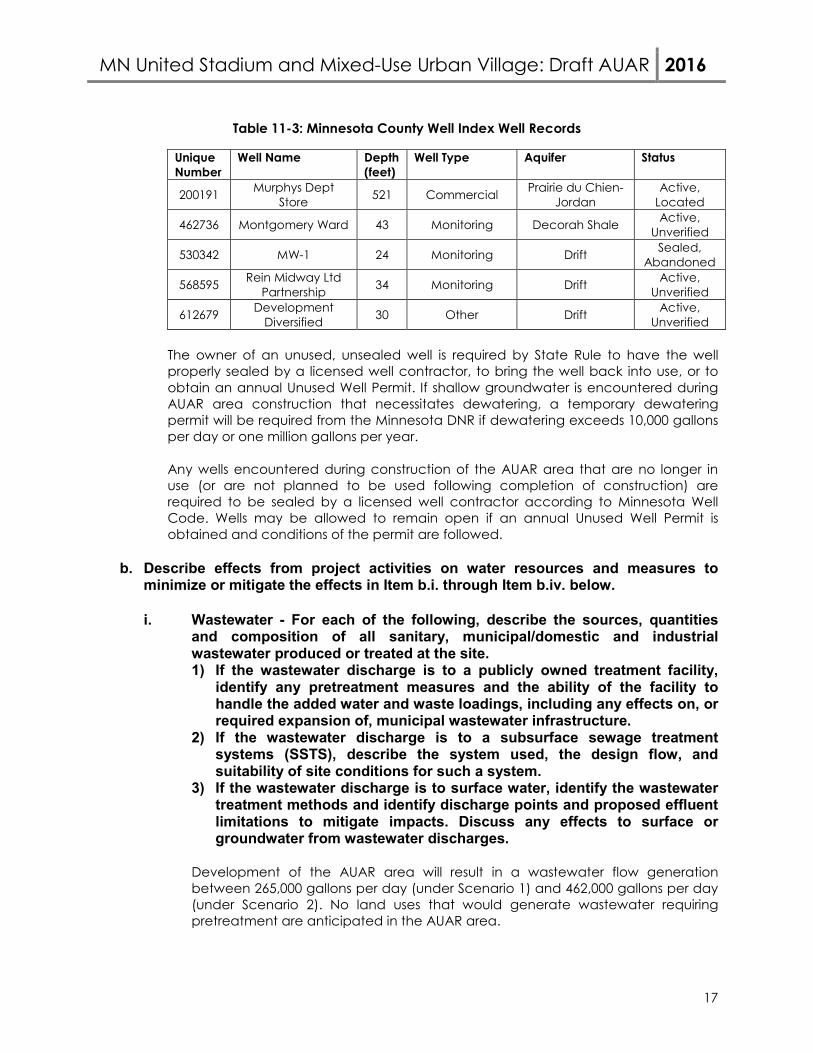
The AUAR area is not within an existing wellhead protection area. The only well with a
“verified” location on the project site is a well with the unique number 200191 and is attributed to “Murphys Department Store.” This is depicted in Figure 11-1. The 16-inch diameter well was constructed in 1959 and was drilled to a depth of 521 feet, being completed in the Prairie du Chien and Jordan aquifers. The well is still listed as “active” in the Minnesota Well Index. However, wells are typically listed as active until information that says otherwise is reported to the State. Four more wells with unverified locations in the AUAR area are identified on the Minnesota Well Index. Table 11-1 lists the wells identified in the AUAR area:
MN United Stadium and Mixed-Use Urban Village: Draft AUAR 2016
17
Table 11-3: Minnesota County Well Index Well Records
Unique Number
Well Name Depth (feet)
Well Type Aquifer Status
200191 Murphys Dept Store 521 Commercial Prairie du Chien-
Jordan Active,
Located
462736 Montgomery Ward 43 Monitoring Decorah Shale Active, Unverified
530342 MW-1 24 Monitoring Drift Sealed, Abandoned
568595 Rein Midway Ltd Partnership 34 Monitoring Drift Active,
Unverified
612679 Development Diversified 30 Other Drift Active,
Unverified
The owner of an unused, unsealed well is required by State Rule to have the well properly sealed by a licensed well contractor, to bring the well back into use, or to obtain an annual Unused Well Permit. If shallow groundwater is encountered during AUAR area construction that necessitates dewatering, a temporary dewatering permit will be required from the Minnesota DNR if dewatering exceeds 10,000 gallons per day or one million gallons per year. Any wells encountered during construction of the AUAR area that are no longer in use (or are not planned to be used following completion of construction) are required to be sealed by a licensed well contractor according to Minnesota Well Code. Wells may be allowed to remain open if an annual Unused Well Permit is obtained and conditions of the permit are followed.
b. Describe effects from project activities on water resources and measures to
minimize or mitigate the effects in Item b.i. through Item b.iv. below.
i. Wastewater - For each of the following, describe the sources, quantities and composition of all sanitary, municipal/domestic and industrial wastewater produced or treated at the site. 1) If the wastewater discharge is to a publicly owned treatment facility,
identify any pretreatment measures and the ability of the facility to handle the added water and waste loadings, including any effects on, or required expansion of, municipal wastewater infrastructure.
2) If the wastewater discharge is to a subsurface sewage treatment systems (SSTS), describe the system used, the design flow, and suitability of site conditions for such a system.
3) If the wastewater discharge is to surface water, identify the wastewater treatment methods and identify discharge points and proposed effluent limitations to mitigate impacts. Discuss any effects to surface or groundwater from wastewater discharges.
Development of the AUAR area will result in a wastewater flow generation between 265,000 gallons per day (under Scenario 1) and 462,000 gallons per day (under Scenario 2). No land uses that would generate wastewater requiring pretreatment are anticipated in the AUAR area.
MN United Stadium and Mixed-Use Urban Village: Draft AUAR 2016
18
Existing private sanitary sewer infrastructure exists within the project limits and will be reused as appropriate. Otherwise, it may need to be cut off and abandoned, unless full removal is deemed necessary. An evaluation of the existing sanitary sewer indicated that it has sufficient capacity to convey the anticipated wastewater flows from either Scenario 1 or 2. New sanitary sewer infrastructure will be sized and installed as needed. No pumping of wastewater is expected to be needed. Existing sanitary sewers to serve the AUAR area are located along Snelling Avenue, Pascal Street, and University Avenue. These will convey wastewater via City sewers to the Metropolitan Council interceptor system and eventually to the Metro Wastewater Treatment Plant. The City of Saint Paul previously reviewed the original SmartSite master plan and determined there was sufficient sanitary sewer capacity to handle the expected wastewater flow from this site. Scenario 1 is based on the SmartSite master plan but includes six additional floors of office use. Scenario 2 has a greater amount of planned floor space, resulting in greater wastewater flows than Scenario 1. Saint Paul Public Works, Sewer Utility has reviewed the plan and does not anticipate any capacity issues within the publicly-owned sanitary sewer system. The City has rezoned a significant area along the Green Line corridor as Traditional Neighborhood, allowing increased density of development. As areas redevelop, wastewater flows are expected to increase along the corridor, requiring an overall evaluation of sanitary sewer capacity in the area. Such an analysis is outside the scope of this AUAR. Due to shallow groundwater likely being present, temporary construction dewatering may be required to complete the project. Any dewatering that exceeds 10,000 gallons per day or one million gallons per year will require an appropriation permit from the Minnesota DNR. The permitting process will review the proposed volume of water to be withdrawn, the depth of the dewatering wells, the potential for impact to other nearby wells, and the potential impact to groundwater-sensitive natural resources. Since the area is fully served by municipal water, it is not expected that many private wells exist in the area. Additionally, private water supply wells would likely be completed in deeper aquifers and would not be impacted by shallow dewatering. At present, there are no known groundwater-sensitive natural resources in close proximity to the AUAR area. Therefore, there appear to be few potential groundwater use conflicts that would prevent obtaining a temporary dewatering permit. Before dewatering can take place, groundwater quality should be tested for the presence of potential contaminants. If contaminants are found, State and local agencies will need to be contacted in order to approve proposed discharge locations and discharge permits. Depending on the type and concentration of contaminants discovered, on-site treatment of contaminated water may be required before off-site discharge is allowed. The proposed discharge points will also determine what permits and approvals are needed prior to discharge taking place.
MN United Stadium and Mixed-Use Urban Village: Draft AUAR 2016
19
MITIGATION STRATEGIES If shallow groundwater is encountered during AUAR area construction that necessitates dewatering, a temporary dewatering permit will be required from the Minnesota DNR if dewatering exceeds 10,000 gallons per day or one million gallons per year. Potential impacts to other wells and groundwater-sensitive natural resources will be investigated as part of the permitting process. Additionally, groundwater will be tested for potential contaminants prior to dewatering. If contaminants are found, appropriate State and local agencies will be contacted in order to determine appropriate discharge locations and/or treatment requirements, including any associated permitting. The MPCA will need to be contacted first to provide direction and oversight, in order to determine if the contamination represents a previously-known release or if it is a newly-discovered release. Additionally, the type and concentration of the contaminant, along with the proposed discharge method, will dictate what types of permits and approvals are required. If discharge of contaminated water is proposed in city sewers, the City of St. Paul will need to review and approve the discharge. If discharge is to take place through sanitary sewers, Met Council Environmental Services will need to be contacted for permitting and approvals before any discharge can occur. As the area develops, an evaluation of wastewater flow generation versus capacity of the existing City sanitary sewer system will need to be performed. At that time, improvements to the City system will be implemented as needed.
ii. Stormwater - Describe the quantity and quality of stormwater runoff at the
site prior to and post construction. Include the routes and receiving water bodies for runoff from the site (major downstream water bodies as well as the immediate receiving waters). Discuss any environmental effects from stormwater discharges. Describe stormwater pollution prevention plans including temporary and permanent runoff controls and potential BMP site locations to manage or treat stormwater runoff. Identify specific erosion control, sedimentation control or stabilization measures to address soil limitations during and after project construction. Stormwater runoff from the AUAR area is directed via pipes and catch basins north to the University Avenue trunk storm system, or else west to Snelling Avenue or east to Pascal Street and then north to the University Avenue trunk storm system. The University Avenue trunk storm system is part of the City’s municipal storm sewer system and discharges into the Mississippi River (Hydrologic Unit Code 07010206) without treatment. A MnDOT manhole and storm sewer are also located at the intersection of Pascal Street and St. Anthony Avenue.
Based on site grades, the majority of the AUAR area can be managed by gravity systems that would convey runoff to the north. For Scenario 2, a portion of the stadium is proposed to be constructed well below existing grades, thus precluding gravity conveyance. For this area, stormwater storage and pumping will likely be needed.
MN United Stadium and Mixed-Use Urban Village: Draft AUAR 2016
20
Stormwater management for the AUAR area is regulated by the City of Saint Paul, Capitol Region Watershed District (CRWD), and State of Minnesota. The City requires that the 100-year stormwater runoff be no more than 1.64 cubic feet per second (cfs) per acre of site disturbance. The CRWD permits no increase in stormwater rates over existing conditions for the 2-, 10-, and 100-year storms, using Atlas 14 precipitation depths and storm distributions. The CRWD also requires that stormwater volume in the amount of 1.1 inch of runoff over the impervious surfaces be retained on site. If infiltration of stormwater is deemed impractical, then alternative compliance sequencing is required. If filtration of stormwater is used, then the required runoff volume shall be multiplied by a factor of 1.82 (i.e., 55% filtration credit). The incorporation of iron-enhanced sand into the filtration medium reduces the factor to 1.25 (or 80% filtration credit). The State, through the NPDES Stormwater Permit, requires treatment of one inch of runoff from new impervious area, if more than one acre of new impervious area is created. The State also requires temporary erosion and sediment control measures be implemented. Preliminary hydrologic analysis was performed based on the master plans for the two scenarios. The total drainage area is 34.4 acres, with an estimate of 85 percent impervious coverage. This reflects industry standard estimates for commercial land use. Applying 85 percent impervious coverage results in an impervious area of 29.2 acres. The CRWD rate control requirements should require minimal stormwater control, as the existing site is largely impervious, resulting in little if any increase in impervious coverage. The City’s rate control requirement will result in more significant need for stormwater management. A preliminary hydrologic model of the proposed site (under either scenario) provides an estimated 100-year runoff rate of 270 cfs. This is based on the Atlas 14 100-year, 24-hour rainfall of 7.46 inches. The City’s rate control requirement calls for this to be reduced to 56 cfs. This is a preliminary number and subject to further analysis and review. The CRWD requires one inch of volume control over the affected impervious area. For an impervious area of 29.2 acres, this results in a runoff volume of 106,000 cubic feet that will need to be captured and managed. The CRWD’s water quality requirement is typically accomplished by the management of the one inch of runoff volume. In addition to the basic regulatory requirements, they City has been leading a stakeholder process to develop preferred stormwater management approaches for the entire AUAR area, including future public right-of-way and greenspace. This process is informed by the City’s shared, stacked-function green infrastructure (SSGI) initiative targeted for transit-oriented development. Preliminary results from this process indicate a strong preference for innovative, sustainable stormwater practices that contribute to place-making for the site. Potential best management practices that have been discussed include interactive fountains, open water features, rain gardens, artistic cisterns, tree trenches, and rainwater/stormwater harvesting for reuse. Any SSGI incorporated into the site will have to be constructed, operated, and maintained in an equitable manner for
MN United Stadium and Mixed-Use Urban Village: Draft AUAR 2016
21
all public and private stakeholders, and agreements for SSGI facilities will need to be generated. Temporary erosion and sediment control measures will also be provided during site construction. Such measures likely will include vegetative restoration, storm drain inlet protection, construction entrance protection, and silt fence. MITIGATION STRATEGIES As the AUAR area develops, stormwater BMPs will be implemented to satisfy City, CRWD, and State requirements. Such BMPs could include stormwater storage for rate control; infiltration, filtration, or bioretention for volume control and water quality treatment; rainwater/stormwater harvesting for reuse for volume control and water quality treatment as well as to reduce potable water demand; and temporary erosion and sediment control features such as vegetative restoration, storm drain inlet protection, construction entrance protection, and silt fence. An effort will be made to address enhanced stormwater management that incorporates SSGI approaches. The Proposers and appropriate stakeholders will need to work out the details of these approaches in the future. Stormwater storage and pumping will likely be needed to address management of the stadium runoff.
iii. Water appropriation - Describe if the project proposes to appropriate
surface or groundwater (including dewatering). Describe the source, quantity, duration, use and purpose of the water use and if a DNR water appropriation permit is required. Describe any well abandonment. If connecting to an existing municipal water supply, identify the wells to be used as a water source and any effects on, or required expansion of, municipal water infrastructure. Discuss environmental effects from water appropriation, including an assessment of the water resources available for appropriation. Identify any measures to avoid, minimize, or mitigate environmental effects from the water appropriation. The proposed construction of the AUAR area will result in a water demand between 290,000 gallons per day (under Scenario 1) and 506,000 gallons per day (under Scenario 2). For Scenario 2, an additional 11,000 gallons per day is estimated to be needed during summer months for irrigation of the soccer stadium field. The water supply will be obtained from the municipal water supply system operated by Saint Paul Regional Water Services (SPRWS). SPRWS obtains their water from the Mississippi River, which is filtered through a chain of lakes and drawn into the treatment plant from Vadnais Lake. The system also has ten water supply wells, which obtain water from the Prairie du Chien and Jordan aquifers. These wells are typically only used for emergency backup or are run at limited volumes in summer or winter to help control temperature and odor from the surface water intakes. By only running the wells at these limited times, SPRWS is
MN United Stadium and Mixed-Use Urban Village: Draft AUAR 2016
22
reducing the potential impact to the available groundwater supplies, relying instead on the available surface water supplies. SPRWS currently has the available permitted capacity to accommodate the 506,000 gallons that the AUAR area may eventually require if Scenario 2 is fully developed. The distribution system has a 16-inch water main on Snelling Avenue and a 12-inch water main on University Avenue that are capable of supplying the needed volume to the AUAR area. Additional water mains are present along Pascal Street and St. Anthony Avenue. SPRWS staff noted that water pressures along this portion of their system are in the lower end of their service range, with 38-42 psi being typical for this area. However, any multi-story structures built in the AUAR area will likely need booster pumps to service the upper floors, regardless of the existing line pressures. Existing private water main infrastructure exists within the project limits and will need to be cut off and abandoned, unless full removal is deemed necessary. Similar to sanitary sewer, temporary construction dewatering may be required to complete the project. See the narrative on temporary dewatering in Section 11.b.i.3. MITIGATION STRATEGIES If shallow groundwater is encountered during AUAR area construction that necessitates dewatering, a temporary dewatering permit will be required from the Minnesota DNR if dewatering exceeds 10,000 gallons per day or one million gallons per year. Potential impacts to other wells and groundwater-sensitive natural resources will be investigated as part of the permitting process. The existing SPRWS water supply system has the available capacity to serve the AUAR area. However, lower pressures of 38-42 psi in the system may necessitate booster pumps for facilities that require greater water pressure. Multi-story structures will need booster pumps to service upper floors with sufficient water pressure.
iv. Surface Waters
a) Wetlands - Describe any anticipated physical effects or alterations to wetland features such as draining, filling, permanent inundation, dredging and vegetative removal. Discuss direct and indirect environmental effects from physical modification of wetlands, including the anticipated effects that any proposed wetland alterations may have to the host watershed. Identify measures to avoid (e.g., available alternatives that were considered), minimize, or mitigate environmental effects to wetlands. Discuss whether any required compensatory wetland mitigation for unavoidable wetland impacts will occur in the same minor or major watershed, and identify those probable locations. No wetlands have been identified in the AUAR area.
MN United Stadium and Mixed-Use Urban Village: Draft AUAR 2016
23
b) Other surface waters- Describe any anticipated physical effects or alterations to surface water features (lakes, streams, ponds, intermittent channels, county/judicial ditches) such as draining, filling, permanent inundation, dredging, diking, stream diversion, impoundment, aquatic plant removal and riparian alteration. Discuss direct and indirect environmental effects from physical modification of water features. Identify measures to avoid, minimize, or mitigate environmental effects to surface water features, including in-water Best Management Practices that are proposed to avoid or minimize turbidity/sedimentation while physically altering the water features. Discuss how the project will change the number or type of watercraft on any water body, including current and projected watercraft usage. No surface water features have been identified in the AUAR area.
12. Solid Wastes, Hazardous Wastes, Storage Tanks
a. Describe types, amounts, and compositions of solid or hazardous wastes, including solid animal manure, sludge, and ash, produced during construction and operation. Identify method and location of disposal. For projects generating municipal solid waste, indicate if there is a source separation plan; describe how the project will be modified for recycling. If hazardous waste is generated, indicate if there is a hazardous waste minimization plan and routine hazardous waste reduction assessments. Construction Construction wastes will be typical relative to the construction of utilities, roads, stadium, hotel and office building structures. Construction wastes will be primarily nonhazardous and can be managed as municipal solid waste (MSW) or construction/demolition debris. However, hazardous wastes in the form of used oils/lubricants, waste paints or other materials may be generated during construction. Through the development review process, the City will require that all Minnesota Pollution Control Agency (MPCA) and other applicable regulatory requirements be met in the management and disposal of construction-related wastes. Recycling will be strongly encouraged, but this will be the responsibility of the developer and/or the construction contractor. Development within the AUAR area may require the complete demolition of the existing Midway Shopping Center, outlot buildings and underground infrastructure. The U.S. Environmental Protection Agency’s (EPA’s) publication Estimating Building-Related Construction and Demolition Materials Amounts was consulted as a basis to estimate that the demolition will generate 25,600 tons of building demolition debris. Demolition debris is inert material such as concrete, brick, glass, plastic, untreated wood, and rock. In addition, approximately 650,000 square feet of bituminous parking area will be removed. It is estimated that up to 70 percent of the solid wastes generated during building demolition and 90 percent of the bituminous will be recycled. The balance will be disposed at a state permitted landfill. The December 2015 Braun Intertec Environmental and Geotechnical Review references test borings in the AUAR area indicating that the upper 2 to 20 feet from the land surface is comprised of man-made fill. Materials encountered may contain substances such as
MN United Stadium and Mixed-Use Urban Village: Draft AUAR 2016
24
lead, asbestos, mercury, or other hazardous substances. The Response Action Plan/Construction Contingency Plan submitted to MPCA in March 2016 details appropriate methods to handle and dispose of any such materials that are encountered. Hazardous waste is not anticipated to be generated during demolition, except for abatement and removal of regulated materials such as asbestos, lead-based paint, refrigeration equipment, lights, and other regulated wastes if they are encountered. A pre-demolition Hazardous Materials Survey of the existing Midway Shopping Center buildings will be completed prior to the start of demolition activities. If any regulated materials such as asbestos-containing materials, lead-based paint, and other regulated materials/wastes are present, an Abatement Plan will be prepared to address removal and proper disposal of regulated materials identified in the Hazardous Materials Survey. Following abatement and demolition activities, a comprehensive Abatement Closeout Report will be prepared, which will document the removal, management, and disposal of the regulated materials. Prior to initiation of subsurface construction activities, the southern half of AUAR area containing the Metropolitan Council, Midway East, University Midway and 4.52 acres of the Midway Shopping Center parcels will be enrolled in the MPCA’s Voluntary Investigation and Cleanup (VIC) Program and Petroleum Brownfields Program (PBP). A Phase II Environmental Site Assessment (Phase II ESA) and Additional Phase II ESA have been completed for the southern half of the AUAR area. Based upon the results of the Phase II ESAs and previously conducted environmental investigations within the this area, a Response Action Plan (RAP) and Construction Contingency Plan (CCP) were prepared and submitted to the VIC and PBP Programs for review and approval to address proper handling and treating of contaminated soil, groundwater and soil vapor within the context of, and consistent with, the proposed redevelopment activities. Specifically, the RAP summarizes environmental response actions and includes procedures for managing contaminated media, subsurface vapors and other environmental mitigation measures during construction. The CCP includes measures for handling unknown contaminated materials that may be encountered during construction. Post-Construction The Energy Information Administration Commercial Building Energy Consumption Survey and Waste Management’s Sustainable Stadiums & Arenas were consulted to estimate amount of municipal solid waste (MSW) generated for the AUAR area. It is estimated that 2,900 to 3,400 tons of MSW will be generated per year based upon the lower end development intensity (Scenario 1) and the maximum development intensity scenarios for the proposed development (Scenario 2). Post-construction waste will be typical of commercial/residential land uses and would be primarily managed as MSW. Some limited volumes of hazardous wastes may be generated. Through the development review process, the City will require that all MPCA and other regulatory requirements be met. Recycling for commercial buildings, including businesses, sport venues and restaurants in the AUAR area will be conducted in accordance with the 2016 Recycling Law (Minnesota Statutes Chapter 115A, Section 115A.151). Recycling for multi-unit dwellings
MN United Stadium and Mixed-Use Urban Village: Draft AUAR 2016
25
will have a recycling service in accordance with Minnesota Statutes Chapter 115A, Section 115A.552.
b. Identify any toxic or hazardous materials to be used or present at the site and identify measures to be used to prevent them from contaminating groundwater. If the use of toxic or hazardous materials will lead to a regulated waste, discharge or emission, discuss any alternatives considered to minimize or eliminate the waste, discharge or emission. Not applicable to an AUAR per EQB AUAR Guidance as no industrial uses are proposed.
c. Indicate the number, location, size, and use of any above or below ground tanks to
store petroleum products or other materials, except water. Describe any emergency response containment plans.
A search of MPCA’s Minnesota Aboveground/Underground Storage Tank Sites website for Zip Code “55104, Ramsey County” revealed three known closed sites that contained storage tanks with soil contamination remaining in the AUAR area:
• Leak Site 2995 – the Arsnelling Garage at 400 N Snelling Avenue • Leak Site 13462 – the Midway Shopping Center at 1564 University Avenue W • Leak site 5912 – a Tank Farm at 400 N Snelling Avenue
A map-based search of the MPCA’s What’s in My Neighborhood database also found the Midway Plaza on University Avenue is listed as VIC Site VP1700; a note to the file indicates a Site Closure was issued. The RAP prepared in March 2016 for the southern portion of the AUAR area indicated that 15 registered underground storage tanks (USTs) historically located on the Metropolitan Council Parcel have been removed. The MPCA’s What’s in My Neighborhood database records for the Metro Transit Garage also indicated the removal of 15 USTs. Fueling activities during construction will comply with MPCA operating and containment requirements. No permanent tanks will be installed within the AUAR area as part of post-construction operations.
POTENTIAL IMPACTS The potential to encounter contaminants is the same under the two development scenarios. Potential impacts of these contaminants include:
• The building demolition will generate an estimated 25,600 tons of debris and remove approximately 650,000 square feet of bituminous parking area.
• A release of petroleum hydrocarbons and volatile organic compounds from the previous site activities to the soil and/or groundwater.
• The range of MSW generated per year based upon the development scenarios is 2,900 to 3,400 tons.
• Potential environmental impacts to the northern portion of the AUAR area have not been investigated.
MN United Stadium and Mixed-Use Urban Village: Draft AUAR 2016
26
MITIGATION STRATEGIES • Complete a pre-demolition Hazardous Building Materials Survey of the existing
buildings in accordance with Minnesota Department of Health (MDH) and MPCA requirements prior to the start of demolition activities to determine if any regulated materials are present. An Abatement Plan will be prepared to address the removal and proper disposal of regulated materials identified in the Hazardous Building Materials Survey.
• Demolition wastes will either be recycled or disposed in the proper facilities. • The southern portion of the AURA area will be enrolled in the MPCA’s VIC Program
and PBP. • A RAP and CCP have been prepared and submitted to the MPCA. The RAP
summarizes environmental response actions and includes procedures for managing contaminated media, subsurface vapors and other environmental mitigation measures during construction. The CCP includes measures for handling unknown contaminated materials that may be encountered during construction.
• Manage MSW according to MPCA and other regulatory requirements. • Investigate the northern portions of the AURA area prior to redevelopment. Prepare
RAP/CCP based on results of the investigation. Complete a pre-demolition Hazardous Building Materials Survey of the existing buildings in accordance with MDH and MPCA requirements prior to the start of demolition activities to determine if any regulated materials are present.
• In the event hazardous materials are encountered (or suspected) during excavation of the man-made fill on site, an environmental investigation to determine the type and volume of these materials will be required, including a plan to safely excavate and properly dispose of the materials encountered. The Response Action Plan/Construction Contingency Plan submitted to MPCA in March 2016 details appropriate methods to handle and dispose of any such materials that are encountered.
13. Fish, wildlife, plant communities, and sensitive ecological resources (rare features):
a. Describe fish and wildlife resources as well as habitats and vegetation on or in near the site. A detailed description of the land cover within the AUAR area is provided in Question 7. Due to the lack of wetlands or surface waters present, the AUAR area does not contain suitable habitat for aquatic species. The AUAR area is primarily developed (i.e., impervious area). Isolated trees and maintained grass areas (0.65 acre) within the AUAR area, and a narrow strip of unmaintained grasses adjacent to the roads and sidewalks along the southwest portions of the property, provide limited habitat for urban wildlife species, such as mice, rabbits, raccoons, squirrels, and song birds, among others.
b. Describe rare features such as state-listed (endangered, threatened or special
concern) species, native plant communities, Minnesota County Biological Survey Sites of Biodiversity Significance, and other sensitive ecological resources on or within close proximity to the site. Provide the license agreement number (LA-____) and/or correspondence number (ERDB _____________) from which the data were obtained and attach the Natural Heritage letter from the DNR. Indicate if any additional habitat or species survey work has been conducted within the site and describe the results.
MN United Stadium and Mixed-Use Urban Village: Draft AUAR 2016
27
Federally Listed Threatened and Endangered Species Per a review of the U.S. Fish and Wildlife Service’s (USFWS’s) Endangered Species website2, there are four federally listed species with a geographic range including Ramsey County:
• Higgins eye pearlymussel (Lampsilis higginsii) – Endangered • Northern long-eared bat (Myotis septentrionalis) – Threatened • Snuffbox (Epioblasma triquetra) – Endangered • Winged mapleleaf (Quadrula fragosa) – Engangered
Due to the lack of wetlands or surface waters present in the AUAR area, no further investigation or an assessment of potential impacts to the Higgins eye pearlymussel, snuffbox, or winged mapleleaf was conducted. The northern long-eared bat (NLEB) is a commonly encountered species throughout the majority of the Midwest during the spring, summer and fall, being commonly captured in mist-net surveys (USFWS 2016b3). However, they are typically found in low numbers in hibernacula (i.e., winter hibernation) in the Midwest (USFWS 2016b). In the winter, NLEB hibernate in large caves and mines that have large passages and entrances, constant temperatures, and high humidity with no air currents. No caves or structures are present within the AUAR area that would provide suitable winter habitat for this species. In the spring, summer and fall, NLEB use a wide variety of forested habitats for roosting, foraging and traveling, and may also utilize some adjacent and interspersed non-forested habitat such as emergent wetlands and edges of fields. This species has also been found roosting in structures like barns and sheds (particularly when suitable tree roosts are unavailable; USFWS 2016b). Roosting habitat includes forested areas with live trees and/or snags with a diameter at breast height (dbh) of at least three inches with exfoliating bark, cracks, crevices and/or other cavities. Trees are considered suitable roost trees if they meet those requirements and are located within 1,000 feet of another suitable roost tree, woodlot, or wooded fencerow (USFWS 2016b). Maternity habitat is defined as suitable summer habitat that is used by juveniles and reproductive females. After hibernation ends in late March or early April, most NLEB migrate to summer roosts. The NLEB active season is the period between emergence and hibernation from April 1 – October 31 (USFWS 2016b).
2 United States Fish and Wildlife Service (USFWS). 2016a.2016. County Distribution of Federally-Listed Threatened, Endangered, Proposed, and Candidate Species. http://www.fws.gov/midwest/endangered/lists/minnesot-cty.html.http://www.fws.gov/midwest/endangered/lists/minnesot-cty.html. Website accessed January 27, 2016. 3 USFWS. 2016b. Programmatic Biological Opinion on Final 4(d) Rule for the Northern Long-Eared Bat and Activities Excepted from Take Prohibitions. USFWS Regions 2, 3, 4, 5, & 6. January 5, 2016.
MN United Stadium and Mixed-Use Urban Village: Draft AUAR 2016
28
Woodland in and near the AUAR area was assessed for bat summer habitat suitability (i.e., non-winter) using published literature on home range size (Owen et al. 20034, Carter and Feldhamer 20055, Lacki et al. 20096) and USFWS guidance on the NLEB (USFWS 2016b). Due to the small number (<15 acres) of trees within the AUAR area or lack of connectivity (i.e., <1,000 feet) to foraging/roosting areas, the AUAR area does not likely contain suitable summer habitat for the NLEB. However, little is known about the migration patterns of bats, specifically how they disperse across the landscape during migration. Therefore, it is not possible to accurately predict an individual bat’s route during migration. Based on this, NLEB have the potential to exist anywhere within the species’ geographic range, including the trees within the AUAR area. Direct mortality from collision with construction equipment is unlikely given that construction activities will occur during daylight hours when bats would not be active. However, tree clearing within the AUAR area may indirectly affect the NLEB. Per a review of the USFWS’s White-Nose Syndrome (WNS) Zone map dated February 29, 20167, Ramsey County, Minnesota is located within 150 miles of a location where WNS has been detected. Therefore, the AUAR area falls within the WNS buffer zone per the Final 4(d) Rule under the Endangered Species Act (ESA). For areas within the WNS buffer zone, the incidental take (e.g., the harm, harassment or killing of a bat as a side effect of otherwise lawful actions, like tree clearing) from tree removal activities is not prohibited unless 1) it results in removing a known occupied maternity roost tree, 2) if tree removal activities occur within 150 feet of a known occupied maternity roost tree from June 1 through July 31, or 3) tree removal activities occur within 0.25 mile of a hibernaculum at any time. Tree removal activities may then proceed without a permit and there is no need to contact the USFWS. Due diligence is generally required to determine if a maternity roost tree or a hibernaculum is on the property; however, per the Final 4(d) Rule, private landowners are not required to conduct surveys on their lands. In Minnesota, the Minnesota Department of Natural Resources (MNDNR) maintains records of maternity roost trees or a hibernaculum within its Natural Heritage Inventory System (NHIS) database. Based upon a guidance document issued by the MNDNR and the USFWS on June 6, 20158, there are two known NLEB records from Ramsey County; however, these records are not located in the same Township as the AUAR area (i.e., Township 29 North, Range
4 Owen, S.F., M.A. Menzel, W.M. Ford, B.R Chapman, K.V. Miller, J.W. Edwards, and P.B. Wood. 2003. Home-range size and
habitat used by the Northern Myotis (Myotis septentrionalis). American Midland Naturalist. 150: 352-359. 5 Carter, T.C., and G.A. Feldhamer. 2005. Roost tree use by maternity colonies of Indiana bats and northern long-eared
bats in southern Illinois. Forest Ecology and Management 219:259-268. 6 Lacki, M.J., D.R. Cox, and M.B. Dickinson. 2009. Meta-analysis of summer roosting characteristics of two species of Myotis
bats. American Midland Naturalist 162:318-326. 7 USFWS. 2016c. White-Nose Syndrome Zone Around WNS/Pd Positive Counties/Districts.
http://www.fws.gov/Midwest/endangered/mammals/nleb/pdf/WNSZone.pdf. February 29, 2016. 8 MNDNR and USFWS. 2015. Townships Containing Northern Long-eared Bat Roost Trees and/or Hibernacula.
http://files.dnr.state.mn.us/eco/ereview/minnesota_nleb_township_list_and_map_20150604.pdf. June 6, 2015.
MN United Stadium and Mixed-Use Urban Village: Draft AUAR 2016
29
23 West, Section 34). As there are no records of NLEB maternity roost trees or a hibernaculum within the AUAR area or a 0.25-mile buffer, incidental take of NLEB as a result of tree removal activities is not prohibited under the Final 4(d) Rule under the ESA. Migratory Birds Construction activities and development within the AUAR area have the potential to impact birds protected under the Migratory Bird Treaty Act (MBTA). The MBTA makes it illegal for anyone to take (i.e., to harass, harm, pursue, hunt, shoot, wound, kill, trap, capture, or collect, or to attempt to engage in any such conduct) any migratory bird, or the parts, nests, or eggs of such a bird except under the terms of a valid permit issued pursuant to Federal regulations. Under the MBTA, construction activities in grassland, roadsides, wetland, riparian (stream), shrubland, or woodland habitats that would otherwise result in the taking of migratory birds, eggs, young and/or active nests should be avoided. Although the provisions of the MBTA are applicable throughout the entire year, most migratory bird nesting activity in Minnesota occurs approximately from mid-March to August 15, per the MNDNR9. The MNDNR references Minnesota B3 Guidelines for developing bird-safe buildings in its comment letter dated March 23, 2016 of the Scoping EAW10. The guidelines include information on building materials to reduce the reflection of glass windows and strategies for light operation to minimize impacts on migratory birds. The B3 Guidelines are required on all projects that receive general obligation bond funding from the State of Minnesota and can also be used on a voluntary basis on any project. According to the USFWS Information for Planning and Conservation (IPaC) Database11, there are 21 migratory birds of concern with the potential to be present within the AUAR area. State-Listed Threatened and Endangered Species Based upon a review of the MNDNR NHIS database under license agreement LA-760, there are no known records of state-listed species within the AUAR area. However, the review indicated one known species record within the project vicinity:
Western Foxsnake (Pantherophis ramspotti) – One known record of this species, observed in October 1939, is located near the intersection of University Avenue and Snelling Avenue. This species does not have special status in Minnesota. Due to the historic date of this record and the urban development in the AUAR area, no further investigation or an assessment of potential impacts to this species was completed.
9 MNDNR. 2014. Best Practices for Meeting DNR GP 2004-0001 (version 4, October 2014).
http://files.dnr.state.mn.us/waters/watermgmt_section/pwpermits/gp_2004_0001_chapter1.pdf. 10 Minnesota B3. B3 Guidelines Version 2.2 (formerly the Minnesota Sustainable Building Guidelines).
http://www.b3mn.org/guidelines/s_14.html. Website accessed March 28, 2016. 11 USFWS. 2016d. Information for Planning and Conservation Database.
https://ecos.fws.gov/ipac/project/VVSUSHDPSRH3VEFQEIW25OV7L4/resources. Website accessed March 21, 2016.

MN United Stadium and Mixed-Use Urban Village: Draft AUAR 2016
30
In addition, an analysis of Minnesota Biological Survey (MBS) data, there are no mapped high quality plant communities or MNDNR-mapped Sites of Biodiversity Significance within the AUAR area or the immediate vicinity. A desktop review of the MNDNR’s Regionally Significant Ecological Areas map (2003) indicates that no portions of the AUAR area have been mapped as areas of ecological biodiversity.
No protected species surveys within the AUAR area were completed due to the prominence of developed land and lack of high quality plant communities.
c. Discuss how the identified fish, wildlife, plant communities, rare features and
ecosystems may be affected by the project. Include a discussion on introduction and spread of invasive species from the project construction and operation. Separately discuss effects to known threatened and endangered species. POTENTIAL IMPACTS This environmental analysis determines that Scenarios 1 and 2 would have similar impacts, including no effect, on fish, wildlife, plant communities, rare features and ecosystems. Neither Scenario 1 nor Scenario 2 will have a significant adverse effect on federally or state-listed threatened and endangered species within the AUAR area. In addition, neither scenario will result in impacts to aquatic species. A small number of trees are present within the AUAR area, which may be utilized by NLEB. Under the Final 4(d) Rule of the ESA, tree clearing is not prohibited as there are no records of NLEB maternity roost trees or a hibernaculum within the AUAR area or a 0.25-mile buffer. Urban wildlife may be impacted by the removal of trees throughout the AUAR area and disturbance to unmaintained grasses adjacent to the roads and sidewalks along the southwest portions of the property; however these habitat generalist species are typically adaptive to development activities and would likely relocate to undeveloped areas in the vicinity or continue to live in the converted green spaces and newly planted trees within the AUAR area. Scenario 2 will result in slightly more maintained green space (1.13 acres) than is proposed in Scenario 1. Construction activities in grassland, roadsides, shrubland, or tree habitats within the AUAR area may result in the taking of migratory birds, eggs, young and/or active nests, if present. Although the provisions of the MBTA are applicable throughout the entire year, most migratory bird nesting activity in Minnesota occurs approximately from mid-March to August 15. When possible, removal of vegetation will occur outside of this timing window to minimize potential take of migratory birds, if present. Construction activities that involve soil disturbance can result in the introduction and spread of invasive species. Minnesota statutes (Chapter 18) and local ordinances regulate management of noxious weeds and invasive species. Best management practices (BMPs) during construction activities and operation within the AUAR area will be implemented to minimize the introduction or spread of noxious weeds and invasive species at the site.
MN United Stadium and Mixed-Use Urban Village: Draft AUAR 2016
31
The MNDNR recommends in its comment letter dated March 23, 2016 that native plants be used for landscaping, including areas such as entrances, roadsides, property borders, parking separation, and infiltration zones.
d. Identify measures that will be taken to avoid, minimize, or mitigate adverse effects
to fish, wildlife, plant communities, and sensitive ecological resources.
Although there are no records of NLEB maternity roost trees or a hibernaculum within the AUAR area or a 0.25-mile buffer, when possible, tree clearing will occur outside of the NLEB pup season, June 1 through July 31. Although a field survey by a qualified biologist could determine the absence/presence of a maternity roost tree within the AUAR area; under the Final 4(d) Rule of the ESA, field surveys are not required to complete due diligence at the site. Prior to tree clearing within the AUAR area, the MNDNR/USFWS-issued list of NLEB records for Minnesota12 must be consulted to ensure activities will not 1) result in removing a known occupied maternity roost tree, 2) occur within 150 feet of a known occupied maternity roost tree from June 1 through July 31, or 3) occur within 0.25 mile of a hibernaculum at any time. The MNDNR anticipates updating this list twice annually on April 1 and October 1. When possible, removal of vegetation will occur outside of the bird nesting window to minimize potential take of migratory birds, if present. If vegetation clearing cannot be avoided during the peak breeding season for migratory birds (approximately mid-March to August 15), a qualified biologist will conduct a pre-construction breeding bird survey within the AUAR area to determine the absence or presence of breeding birds and their nests. Pre-construction breeding bird surveys may include: 1. Pre-construction surveys that occur no more than two weeks before tree and shrub
clearing activities commence. The area surveyed will include the areas where potential suitable habitat has been identified and tree or shrub clearing has not been completed.
2. If an occupied nest is observed during the survey, tree and shrub clearing activities will not be permitted within a 0.12-mile buffer of the nest site during the breeding season or until the fledglings have left the area. Consult with the USFWS to avoid take of the species.
3. Upon completion, the survey results will be submitted to the USFWS, as appropriate. If breeding birds are not present, construction can proceed with no restrictions. If breeding birds or active nests are present, additional consultation will be required.
The Minnesota B3 Guidelines identify strategies for developing bird-safe buildings and are required on all projects that receive general obligation bond funding from the State of Minnesota; however, these guidelines can also be used on a voluntary basis on any project. BMPs and erosion and sediment control devices (ESCDs) will be used during construction activities as required by the City’s NPDES MS4 Permit, SWPPP and Construction Site
12 MNDNR and USFWS. 2015. Townships Containing Northern Long-eared Bat Roost Trees and/or Hibernacula.
http://files.dnr.state.mn.us/eco/ereview/minnesota_nleb_township_list_and_map_20150604.pdf. June 6, 2015.
MN United Stadium and Mixed-Use Urban Village: Draft AUAR 2016
32
Stormwater Permit to prevent sediment-laden stormwater runoff from the AUAR area into receiving waterbodies, which could adversely impact habitats of aquatic and avian wildlife. Construction activities will adhere to requirements outlined in Title VI, Chapter 33.03(g) of the City of St. Paul Code for planned development. MITIGATION STRATEGIES
• Tree clearing will occur during winter (i.e., mid-August to mid-April) to minimize impacts on NLEB and migratory birds. If tree clearing during this window cannot be avoided, additional steps, including but not limited to field surveys, must be completed. Refer to the detailed analysis above.
• If project activities will receive general obligation bond funding from the State of Minnesota, building and other construction designs must adhere to the Minnesota B3 Guidelines, which include strategies for developing bird-safe buildings and meet other sustainability goals. These guidelines can also be used on a voluntary basis on any project.
• If project activities receive more than $200,000 from the City of Saint Paul or Saint
Paul HRA, the project will comply with the Saint Paul Sustainable Building Policy.
• BMPs and ESCDs will be used during construction activities to prevent sediment-laden stormwater runoff from the AUAR area.
• Native plants will be used for landscaping within the AUAR area to prevent the introduction and spread of invasive plants and noxious weeds.
14. Historic properties
Describe any historic structures, archeological sites, and/or traditional cultural properties on or in close proximity to the site. Include: 1) historic designations, 2) known artifact areas, and 3) architectural features. Attach letter received from the State Historic Preservation Office (SHPO). Discuss any anticipated effects to historic properties during project construction and operation. Identify measures that will be taken to avoid, minimize, or mitigate adverse effects to historic properties. The AUAR area and surrounding neighborhoods have been fully developed for decades. A review of Sanborn Insurance Maps indicates the entire AUAR area was used for operations by the Twin City Rapid Transport Co. streetcar operator from at least the year 1925, and possibly as early as 1903. Operations included construction and maintenance of street cars, and structures on the site included a paint shop, machine shop, foundry, blacksmith shop, pipe shop, and warehouses and offices. The northern part of the AUAR area is the current location of the Midway Shopping Center, an auto-oriented mall built in 1954. The southern part of the AUAR area is the former location of the Metro Transit Bus Barn, built in 1954. Some of the original streetcar operations buildings on the site may have remained at that time and been demolished after 1954. The bus barn was demolished in 2001. No structures are currently present in the southern part of the AUAR area.
MN United Stadium and Mixed-Use Urban Village: Draft AUAR 2016
33
A search of the Minnesota Historic Society Historic Resources Inventory revealed that no structures or ruins on the AUAR area or its close proximity are listed on the National Register for Historic Places (NHRP). However, a number of properties in and around the AUAR area are eligible for review for the NHRP due to their age and contribution to the commercial corridor along University Avenue. These structures were identified as a part of the environmental review for the Green Line LRT. Within the AUAR area, three structures were identified:
• Midway National Bank (American Bank) at 1578 University Ave. W. • Midway Shopping Center West Building (Big Top Liquor) at 1460 University Ave. W. • Minneapolis & Saint Paul Railway Snelling Ave. Paint Shop at 400 Snelling Ave. This
is known as the “Bus Barn Site”. As noted above, the building was demolished in 2001.
The Green Line LRT environmental review also identified one property across the street from the AUAR area that is also eligible for NHRP review:
• Former Quality Park Investment Company at 1579 University Ave. W. The property now houses Midway Books, a used and rare bookstore.
No archeological sites in or around the AUAR area were identified as part of the inventory search. POTENTIAL IMPACTS
• Scenario 1 proposes full development of the site, including demolition of all existing buildings. Two buildings in the AUAR area that are eligible for NHRP listing would be demolished: the Midway National Bank and the Midway Shopping Center West Building. No impacts to archeological sites or traditional cultural properties are anticipated.
• Scenario 2 proposes full development of the site, including demolition of all existing buildings. Two buildings in the AUAR area that are eligible for NHRP listing would be demolished: the Midway National Bank and the Midway Shopping Center West Building. No impacts to archeological sites or traditional cultural properties are anticipated.
MITIGATION STRATEGIES After consultation with the Minnesota State Historic Preservation Office, the Proposers initiated a Phase I Cultural Resources Analysis which includes a literature review and archeological assessment to determine if any important features exist today in the AUAR area and its close proximity. The report also addresses the historic status of the Midway National Bank and the Midway Shopping Center West Building in the AUAR area and the former Quality Park Investment Company north of University Avenue. This report is included in Appendix B of this document and has been submitted to SHPO for review. Appropriate mitigation strategies will be developed in response to SHPO’s review. No federal funding or assistance is currently anticipated for development of the AUAR area. Thus, only State of Minnesota historic review processes will be required.
MN United Stadium and Mixed-Use Urban Village: Draft AUAR 2016
34
15. Visual Describe any scenic views or vistas on or near the project site. Describe any project related visual effects such as vapor plumes or glare from intense lights. Discuss the potential visual effects from the project. Identify any measures to avoid, minimize, or mitigate visual effects.
Scenic Views The AUAR area is located in a fully developed, urban, commercial area of St. Paul. The AUAR area is currently occupied by a shopping mall, large surface parking lot and vacant bus barn site, none of which provide scenic views to neighboring properties. There are no nearby scenic views or vistas around the AUAR area that would be impacted by development of Scenario 1 or Scenario 2. The AUAR area is bordered by Interstate 94 on the south, limiting views of future development from the south. Nearby residential neighborhoods are located south of I-94, west of Snelling Avenue and north of University Avenue. All immediate neighboring properties are commercial in use. Visual Effects No adverse visual effects are anticipated in relationship to development of Scenario 1. Scenario 1 anticipates full buildout of the AUAR area in a manner that is consistent with surrounding properties.
Buildout of Scenario 2 could result in visual effects related to light trespass from stadium field lighting. The stadium’s planned design locates sports light fixtures underneath the stadium’s canopy. Figure 15-1 depicts anticipated mounting conditions of light fixtures to direct glow toward the playing field. Fixtures will have internal shielding and external glare shrouds and will be aimed to optimize the lighting on the playing field. All fixtures will be aimed down so that no direct lighting will leave the confines of the stadium. There will be a glow from the reflected light but it will be limited and no light pollution will impact the surrounding areas. MITIGATION STRATEGIES For any development in the AUAR area, the City of Saint Paul will enforce Sec. 63.116 of its Zoning Code, which states the following:
(a) All outdoor lighting in all use districts, including off-street parking facilities, shall be shielded to reduce glare and shall be so arranged as to reflect lights away from all adjacent residential districts or adjacent residences in such a way as not to exceed three (3) footcandles measured at the residence district boundary.
(b) All lighting in all districts used for the external illumination of buildings shall be placed and shielded so as not to interfere with the vision of persons on adjacent highways or adjacent property.
(c) Illumination of any other outdoor feature shall be maintained stationary and constant in intensity and color at all times when in use.
16. Air
a. Stationary source emissions - Describe the type, sources, quantities and compositions of any emissions from stationary sources such as boilers or exhaust stacks. Include any hazardous air pollutants, criteria pollutants, and any
MN United Stadium and Mixed-Use Urban Village: Draft AUAR 2016
35
greenhouse gases. Discuss effects to air quality including any sensitive receptors, human health or applicable regulatory criteria. Include a discussion of any methods used assess the project’s effect on air quality and the results of that assessment. Identify pollution control equipment and other measures that will be taken to avoid, minimize, or mitigate adverse effects from stationary source emissions. No stationary source emissions are anticipated through development of the AUAR area.
b. Vehicle emissions - Describe the effect of the project’s traffic generation on air emissions. Discuss the project’s vehicle-related emissions effect on air quality. Identify measures (e.g. traffic operational improvements, diesel idling minimization plan) that will be taken to minimize or mitigate vehicle-related emissions. Motorized vehicles affect air quality by emitting airborne pollutants. Changes in traffic volumes, travel patterns, and roadway locations affect air quality by changing the number of vehicles and the congestion levels in a given area. The air quality impacts for this environmental review were analyzed by addressing criteria pollutants, a group of six common air pollutants regulated by the U.S. Environmental Protection Agency (EPA). In addition to the criteria air pollutants, the EPA also regulates air toxics. These include seven compounds with significant contributions from mobile sources. A qualitative evaluation of Mobile Source Air Toxics (MSATs) was performed for this environmental review. The scope and methods of these analyses were developed in collaboration with the City of Saint Paul, Minnesota Pollution Control Agency (MPCA), and the Minnesota Department of Transportation (MnDOT). The complete Snelling Midway Air Quality Technical Memorandum documenting this analysis is provided in Appendix C. Summary of Analysis and Findings Carbon Monoxide (CO) is a traffic-related pollutant that has been a concern in the Twin Cities Metropolitan area. This assessment was completed to evaluate the impacts of additional traffic generated by the development on regional air quality levels and to identify whether this project would cause or contribute to a new localized exceedance of carbon monoxide (CO) ambient air quality standards. Vehicles queued at congested intersections emit CO, which may contribute to elevated CO concentrations near the roadways where pedestrians may be present. The analysis completed for the proposed development included three scenarios representing different conditions expected to occur. The scenarios include: • 2018 Stadium Build Scenario – this condition reflects traffic patterns and volumes that
would be expected to occur prior to an evening event at the proposed stadium. Increased traffic congestion would be expected as a result of additional event traffic along with normal p.m. peak period traffic.
• 2035 Comprehensive Plan Full Buildout Scenario – this condition reflects traffic patterns and volumes that would be expected to occur once all of the proposed development at the Snelling Midway site has been completed, including residential and commercial land uses. Increased traffic would be expected from the additional land uses proposed.

MN United Stadium and Mixed-Use Urban Village: Draft AUAR 2016
36
• Construction Scenario – this condition reflects increased traffic congestion along roadways adjacent to the Snelling Midway site that may occur due to temporary lane closures resulting from construction equipment.
The results of the analysis detailed in the Technical Memorandum demonstrate that concentrations of CO in the project area would be substantially below the state and federal standards, and that no exceedances are anticipated due to additional traffic generated by the proposed development. POTENTIAL IMPACTS The qualitative evaluation of MSATs considered the additional activity associated with the proposed development which could have the effect of increasing emissions in the vicinity of nearby homes and businesses. The increased traffic associated with the Stadium Build and Comprehensive Plan Full Buildout scenarios would lead to higher MSAT emissions in the vicinity of the development site. The higher emissions could be offset somewhat by a decrease in regional traffic due to increased use of transit during events. Therefore, under the build scenarios there may be localized areas where ambient concentrations of MSATs would be higher than under the no build conditions. However, the magnitude and duration of these potential differences cannot be reliably quantified, as noted in the Technical Memorandum, due to incomplete or unavailable information in forecasting project-specific health impacts. On a region-wide basis, EPA's vehicle and fuel regulations, coupled with fleet turnover, will cause substantial reductions over time that in almost all cases the MSAT levels in the future will be significantly lower than today.
MITIGATION STRATEGIES The analysis presented in the Technical Memorandum demonstrates there will be no anticipated exceedances of air pollutant concentrations resulting from the proposed project; therefore, no mitigation measures are necessary. The State of Minnesota does not require permits for traffic-related emissions for projects of this type. This analysis also demonstrates that no exceedances are anticipated under the construction phase. However, a series of Best Management Practices (BMPs) would be implemented during construction to control dust. This may include the following preventive and mitigative measures: • Minimization of land disturbance during site preparation
• Use of watering trucks to minimize dust
• Covering of trucks while hauling soil/debris off-site or transferring materials
• Stabilization of dirt piles if they are not removed immediately
• Use of dust suppressants on unpaved areas
• Minimization of unnecessary vehicle and machinery idling
• Revegetation of any disturbed land post-construction
c. Dust and odors - Describe sources, characteristics, duration, quantities, and
intensity of dust and odors generated during project construction and operation.
MN United Stadium and Mixed-Use Urban Village: Draft AUAR 2016
37
(Fugitive dust may be discussed under item 16a). Discuss the effect of dust and odors in the vicinity of the project including nearby sensitive receptors and quality of life. Identify measures that will be taken to minimize or mitigate the effects of dust and odors.
Per EQB Guidance, dust and odors need not be addressed in an AUAR (as no industrial uses are proposed) unless there is some unusual reason to do so. There is no unusual reason to do so with respect to the proposed project.
17. Noise
Describe sources, characteristics, duration, quantities, and intensity of noise generated during project construction and operation. Discuss the effect of noise in the vicinity of the project including 1) existing noise levels/sources in the area, 2) nearby sensitive receptors, 3) conformance to state noise standards, and 4) quality of life. Identify measures that will be taken to minimize or mitigate the effects of noise. This section presents noise impacts associated with soccer events in the stadium and vehicular traffic resulting from new development in the AUAR area. Noise is defined as any unwanted sound. Sound travels in a wave motion and produces a sound pressure level. This sound pressure level is commonly measured in decibels. Decibels (dB) represent the logarithm of the ratio of a sound energy relative to a reference sound energy. An adjustment, or weighting, of the high- and low- pitched sound is made to approximate the way that an average person hears sound. The adjusted sound levels are stated in units of “A-weighted decibels” (dBA). A sound increase of 3 dBA is barely noticeable by the human ear, a 5 dBA increase is clearly noticeable, and a 10 dBA increase is heard as twice as loud. Stadium Noise The following is a summary of the Minnesota United MLS Stadium Preliminary Community Noise Review. The complete Minnesota United MLS Stadium Preliminary Community Noise Review is in Appendix D. This review includes background information on noise, discussion of State and City noise regulations, information about the existing ambient noise environment, predicted stadium public address system and crowd noise levels, and recommended mitigation measures.
A study of potential noise impact from the proposed MLS stadium operations was based upon the current concept design for the stadium. The primary use of the stadium is for MLS soccer games, although other sporting events can be expected, along with limited amplified music as a pre-game activity (not concerts) associated with sports events. No amplified music concerts for the seating bowl are planned for the stadium.
The dominant community noise sources were determined to be the stadium public address system and crowd noise. Typical sound system and crowd noise levels were measured at a similar, existing MLS stadium (Sporting KC) during a soccer match.
Field measurement data from Sporting KC were used to calibrate a 3D computer model of the proposed stadium sound levels using this project’s specific architectural configuration and loudspeaker system.
MN United Stadium and Mixed-Use Urban Village: Draft AUAR 2016
38
Existing, ambient sound level measurements at Class II receptors (residential) nearest the site were performed during anticipated event hours of 12 noon to 12 midnight. Existing ambient noise levels for the properties in the environs of the site were found to be due to traffic operations on I-94 and the surrounding surface streets, which are busy during the daytime due to the existing commercial developments.
Noise Regulations
The applicable noise criteria for the project are established by the State of Minnesota Pollution Control Agency and the City of St. Paul Noise Ordinance (Code of Ordinances, Chapter 293). The objective noise level limits are based on the land use of affected properties and the time of day. The level exceeded 50 percent of the time (L50) and the level exceeded 10 percent of the time (L10) are the noise level descriptors used in the regulations. The L50 value is the sound level exceeded more than 30 minutes of any given hour, and the L10 value is the sound level exceeded more than 6 minutes of any given hour.
The City of St. Paul noise level limits are based on the L10 descriptor. All levels are A-weighted (dBA).
POTENTIAL IMPACTS – Scenario 2 Measurements from the similar stadium indicated that the stadium public address system is much more likely to potentially violate the City noise regulations than crowd noise, due to both the shorter duration of crowd noise in any given hour and its propagation over distance characteristics. Figure 17-1 shows the calculated L10 sound levels from stadium game operations. Calculated sound levels from the stadium permanent seating bowl sound system and crowd noise, based on the typical MLS game presentation, the current sound system configuration, the current architectural design, and reference noise level measurements, are not expected to exceed the City of St. Paul daytime noise level standard at the closest noise-sensitive uses. Daytime noise levels would exceed standards for residential uses proposed in Scenario 2 at locations north and east of the stadium (see Figure 17-2). During nighttime hours, the sound system may exceed the applicable sound level limit, depending on how long an event extends beyond 10:00 pm and how loudly the sound system is operated. Crowd noise may also exceed the City’s nighttime limits. In all cases of exceedance of standards, mitigation in some form will be needed. The measured ambient levels indicate that sound from stadium sporting events, even when compliant with the City regulations, can be expected to be audible at the homes and properties nearest the site.
MITIGATION STRATEGIES As the house sound system has the potential to exceed the City noise level limits, it is recommended that:
• The overall system loudness should be electronically limited so that levels in the spectator seating cannot exceed levels that are compliant with the City standards. The calculations assume a maximum of 90 dBA at the spectator seating to limit the noise level at the closest residences to 65 dBA L10.
MN United Stadium and Mixed-Use Urban Village: Draft AUAR 2016
39
• Sporting events must be scheduled so that regulation play is completed by 10 pm or obtain a sound level variance.
• Plaza amplified sound sources are to be configured and operated at levels which are consistent with the City noise standards.
• Any amplified music associated with stadium events, such as small musical groups performing pre-game in the seating bowl or exterior plaza, must be limited in loudness to comply with the City noise ordinance.
• Continuous pre-game and half time stadium sound system levels will likely have to be lower than in game announcements, in order to meet the City noise regulations.
• Future development on the stadium site should be designed with the understanding of the activities occurring at and noise levels generated by the stadium. Construction of Class II receptor uses within the 65 dBA, L10 contour will require mitigation through decreased stadium sound levels or other means, such as a sound level variance.
Vehicular Traffic Noise The following section summarizes the Snelling Midway AUAR Area Traffic Noise Analysis Memorandum. The complete Snelling Midway AUAR Area Traffic Noise Analysis Memorandum is included in Appendix E. This memorandum includes background information on noise, information regarding state noise standards, a discussion of the traffic noise analysis methodology, documentation of modeled traffic noise levels within the AUAR area, and an evaluation of measures to minimize or mitigate noise impacts on planned land uses within the AUAR area. Existing Noise Levels/Sources in the Area Existing noise sources in the vicinity of the AUAR area include noise generated by vehicular traffic traveling on area roadways as well as by Green Line LRT traffic (LRT vehicles and horn noise). Noise level monitoring is commonly performed as part of a traffic noise study to document existing traffic noise levels and to validate the noise model for the project (see discussion of “Field Measurements and Predicted Noise Levels” below). Existing noise levels were monitored at three locations within the AUAR area. Noise monitoring locations are illustrated in Figure 17-3 and described below. • Monitoring Site 1 (M-1) is located along St. Anthony Avenue and the south side of the
AUAR area, northwest of the Pascal Street/St. Anthony Avenue intersection. • Monitoring Site 2 (M-2) is located along Pascal Street and the east side of the AUAR area,
approximately half-way between University Avenue and St. Anthony Avenue. • Monitoring Site 3 (M-3) is located is along the west side of the AUAR area near the
Snelling Avenue/St. Anthony Avenue intersection.
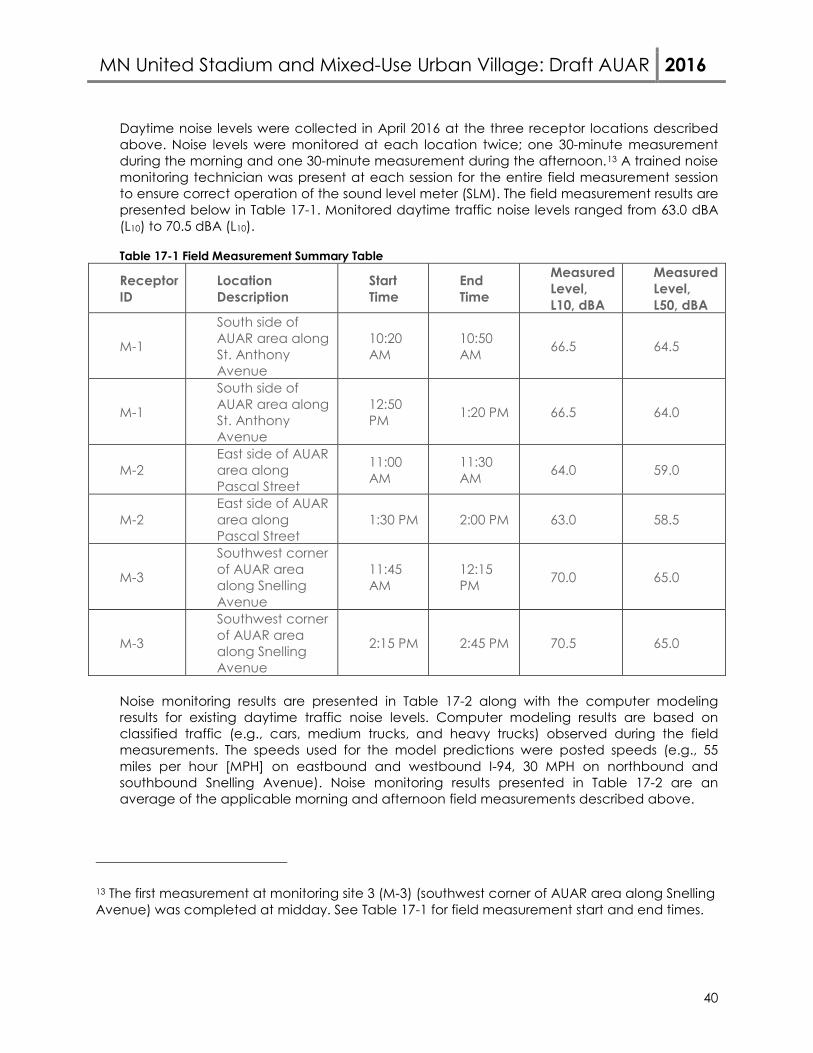
MN United Stadium and Mixed-Use Urban Village: Draft AUAR 2016
40
Daytime noise levels were collected in April 2016 at the three receptor locations described above. Noise levels were monitored at each location twice; one 30-minute measurement during the morning and one 30-minute measurement during the afternoon.13 A trained noise monitoring technician was present at each session for the entire field measurement session to ensure correct operation of the sound level meter (SLM). The field measurement results are presented below in Table 17-1. Monitored daytime traffic noise levels ranged from 63.0 dBA (L10) to 70.5 dBA (L10). Table 17-1 Field Measurement Summary Table
Receptor ID
Location Description
Start Time
End Time
Measured Level, L10, dBA
Measured Level, L50, dBA
M-1
South side of AUAR area along St. Anthony Avenue
10:20 AM
10:50 AM 66.5 64.5
M-1
South side of AUAR area along St. Anthony Avenue
12:50 PM 1:20 PM 66.5 64.0
M-2 East side of AUAR area along Pascal Street
11:00 AM
11:30 AM 64.0 59.0
M-2 East side of AUAR area along Pascal Street
1:30 PM 2:00 PM 63.0 58.5
M-3
Southwest corner of AUAR area along Snelling Avenue
11:45 AM
12:15 PM 70.0 65.0
M-3
Southwest corner of AUAR area along Snelling Avenue
2:15 PM 2:45 PM 70.5 65.0
Noise monitoring results are presented in Table 17-2 along with the computer modeling results for existing daytime traffic noise levels. Computer modeling results are based on classified traffic (e.g., cars, medium trucks, and heavy trucks) observed during the field measurements. The speeds used for the model predictions were posted speeds (e.g., 55 miles per hour [MPH] on eastbound and westbound I-94, 30 MPH on northbound and southbound Snelling Avenue). Noise monitoring results presented in Table 17-2 are an average of the applicable morning and afternoon field measurements described above.
13 The first measurement at monitoring site 3 (M-3) (southwest corner of AUAR area along Snelling Avenue) was completed at midday. See Table 17-1 for field measurement start and end times.
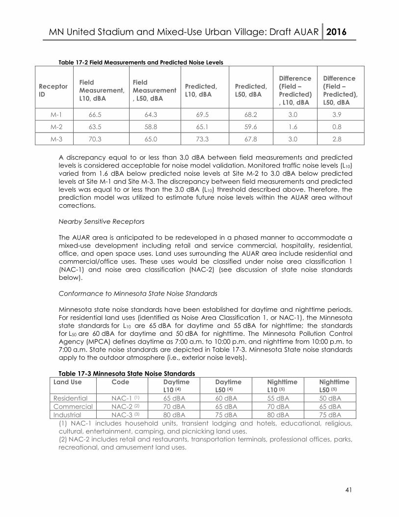
MN United Stadium and Mixed-Use Urban Village: Draft AUAR 2016
41
Table 17-2 Field Measurements and Predicted Noise Levels
Receptor ID
Field Measurement, L10, dBA
Field Measurement, L50, dBA
Predicted, L10, dBA
Predicted, L50, dBA
Difference (Field – Predicted), L10, dBA
Difference (Field – Predicted), L50, dBA
M-1 66.5 64.3 69.5 68.2 3.0 3.9
M-2 63.5 58.8 65.1 59.6 1.6 0.8
M-3 70.3 65.0 73.3 67.8 3.0 2.8 A discrepancy equal to or less than 3.0 dBA between field measurements and predicted levels is considered acceptable for noise model validation. Monitored traffic noise levels (L10) varied from 1.6 dBA below predicted noise levels at Site M-2 to 3.0 dBA below predicted levels at Site M-1 and Site M-3. The discrepancy between field measurements and predicted levels was equal to or less than the 3.0 dBA (L10) threshold described above. Therefore, the prediction model was utilized to estimate future noise levels within the AUAR area without corrections. Nearby Sensitive Receptors The AUAR area is anticipated to be redeveloped in a phased manner to accommodate a mixed-use development including retail and service commercial, hospitality, residential, office, and open space uses. Land uses surrounding the AUAR area include residential and commercial/office uses. These uses would be classified under noise area classification 1 (NAC-1) and noise area classification (NAC-2) (see discussion of state noise standards below). Conformance to Minnesota State Noise Standards Minnesota state noise standards have been established for daytime and nighttime periods. For residential land uses (identified as Noise Area Classification 1, or NAC-1), the Minnesota state standards for L10 are 65 dBA for daytime and 55 dBA for nighttime; the standards for L50 are 60 dBA for daytime and 50 dBA for nighttime. The Minnesota Pollution Control Agency (MPCA) defines daytime as 7:00 a.m. to 10:00 p.m. and nighttime from 10:00 p.m. to 7:00 a.m. State noise standards are depicted in Table 17-3. Minnesota State noise standards apply to the outdoor atmosphere (i.e., exterior noise levels). Table 17-3 Minnesota State Noise Standards
Land Use Code Daytime L10 (4)
Daytime L50 (4)
Nighttime L10 (5)
Nighttime L50 (5)
Residential NAC-1 (1) 65 dBA 60 dBA 55 dBA 50 dBA Commercial NAC-2 (2) 70 dBA 65 dBA 70 dBA 65 dBA Industrial NAC-3 (3) 80 dBA 75 dBA 80 dBA 75 dBA
(1) NAC-1 includes household units, transient lodging and hotels, educational, religious, cultural, entertainment, camping, and picnicking land uses. (2) NAC-2 includes retail and restaurants, transportation terminals, professional offices, parks, recreational, and amusement land uses.

MN United Stadium and Mixed-Use Urban Village: Draft AUAR 2016
42
(3) NAC-3 includes industrial manufacturing, transportation facilities (except terminals), and utilities land uses. (4) Daytime hours are from 7:00 a.m. to 10:00 p.m. (5) Nighttime hours are from 10:00 p.m. to 7:00 a.m. State noise standards apply to trunk highway facilities and roadways within the cities of Minneapolis and St. Paul. Exemptions to state noise standards are found in Minnesota Statutes 2000, Section 116.07 subd. (2a). State noise standards apply to all roadways surrounding the AUAR area.
POTENTIAL IMPACTS AUAR Area Receptor Locations Traffic noise levels were assessed at 68 representative receptors located at incremental distances from the right of way limits along the north, east, south, and west sides of the AUAR area (e.g., 0 feet, 50 feet, 100 feet, 150 feet, 200 feet, 250 feet, 300 feet, 350 feet, and 400 feet). The purpose of locating representative receptors at these locations was to identify setback distances from existing right of way where modeled traffic noise levels would be at or below state daytime and nighttime standards for different noise area classifications. This analysis was based on existing topography, and assumed no intervening barriers or structures between the modeled receptor locations and roadways adjacent to the AUAR area. Modeled receptor locations are illustrated in Figure 17-3. As noted above, existing noise sources in the vicinity of the AUAR area includes traffic noise and from operations of the Green Line LRT. This analysis only considers L10 and L50 noise levels generated by vehicles (cars, medium trucks, heavy trucks) traveling on area roadways and does not include an evaluation of Green Line LRT. Daytime L10 modeled noise levels within the AUAR area are predicted to range from 59.6 dBA to 74.1 dBA under future (2035) Build conditions, whereas daytime L50 modeled noise levels are predicted to range from 57.8 dBA to 70.6 dBA. Daytime traffic noise levels are projected to increase by approximately 0.4 dBA to 1.1 dBA (L10) compared to existing conditions. Nighttime L10 modeled noise levels within the AUAR area are predicted to range from 58.3 dBA to 73.4 dBA under future (2035) Build conditions, whereas nighttime L50
modeled noise levels are predicted to range from 53.0 dBA to 70.3 dBA. Nighttime traffic noise levels are projected to increase by approximately 0.3 dBA to 1.1 dBA (L10) compared to existing conditions. Traffic noise levels were also modeled under future (2035) Build conditions for weekend event arrival (1:00 p.m. – 2:00 p.m.) and departure (4:00 p.m. – 5:00 p.m.) periods. Modeled daytime L10 traffic noise levels for weekend event arrival and departure periods are predicted to range from 58.9 dBA to 73.2 dBA. Modeled daytime L50 traffic noise levels for weekend event arrival and departure periods are predicted to range from 57.6 dBA to 70.1 dBA. In general, daytime traffic noise levels for the weekday worst noise hour were predicted to be approximately 1 dBA (L10) greater than weekend event arrival and departure periods. Modeled noise levels under future Build conditions are compared to state daytime and nighttime standards for NAC-1 and NAC-2 below.
MN United Stadium and Mixed-Use Urban Village: Draft AUAR 2016
43
• Modeled daytime L10 noise levels within the AUAR area were projected to exceed State
daytime standards for NAC-1 (65 dBA) at distances ranging from 50 feet to 300 feet from area roadways. Modeled daytime L50 noise levels within the AUAR area were projected to exceed state standards for NAC-1 (60 dBA) out to 400 feet from adjacent roadways.
• Modeled nighttime L10 and L50 noise levels were predicted to exceed state nighttime standards for NAC-1 at all modeled receptor locations within the AUAR area.
• Modeled L10 and L50 noise levels were predicted to be below state daytime standards for NAC-2 at all modeled receptor locations along University Avenue and Pascal Street, and at distances ranging from 50 feet to 200 feet along Snelling Avenue and St. Anthony Avenue.
• Modeled L10 and L50 noise levels were predicted to be below state nighttime standards for NAC-2 at all modeled receptor locations within the AUAR area along University Avenue, Pascal Street, and Snelling Avenue. Modeled L10 and L50 noise levels were predicted to be below state nighttime standards for NAC-2 at distances of up to 150 feet from St. Anthony Avenue.
Receptors Surrounding the AUAR Area Traffic noise levels were modeled at 12 representative receptor locations surrounding the AUAR area along Snelling Avenue, University Avenue, and Pascal Street representing residential, commercial, and transportation (Snelling Avenue LRT Station). Modeled receptor locations are illustrated in Figure 17-3. Future (2035) daytime L10 noise levels at modeled receptor locations surrounding the AUAR area with the proposed development are predicted to range from 57.7 dBA to 74.6 dBA, whereas L50 modeled noise levels range from 53.8 dBA to 70.8 dBA. Nighttime L10 noise levels at modeled receptor locations surrounding the AUAR area under the Build scenario are predicted to range from 55.0 dBA to 74.4 dBA, whereas L50 modeled noise levels are predicted to range from 52.2 dBA to 70.3 dBA. Modeled daytime and nighttime traffic noise levels are predicted to increase by 0.2 dBA to 1.1 dBA (L10) under Build Alternative conditions compared to existing conditions. Modeled daytime L10 traffic noise levels for weekend event arrival and departure periods at receptor locations surrounding the AUAR area are predicted to range from 56.9 dBA to 74.3 dBA. Modeled daytime L50 traffic noise levels for weekend event arrival and departure periods are predicted to range from 53.3 dBA to 70.2 dBA. Modeled noise levels at commercial receptor locations along Snelling Avenue and University Avenue were predicted to be approximately 1 dBA (L10) up to nearly 3 dBA (L50) greater during event arrival and departure periods compared to the weekday worst noise hour. Modeled noise levels at receptor locations surrounding the AUAR area are compared to state daytime and nighttime standards for NAC-1 and NAC-2 below.
• Modeled noise levels exceed State daytime and nighttime L10 and L50 standards for NAC-1 at residential land uses along the west side of Snelling Avenue and north of St. Anthony Avenue under existing conditions, the future No Build Alternative, and future Build Alternative.
MN United Stadium and Mixed-Use Urban Village: Draft AUAR 2016
44
• In general, modeled noise levels are below State daytime L10 and L50 standards for NAC-2 at modeled commercial receptor locations surrounding the AUAR area under existing conditions, the future No Build Alternative, and future Build Alternative. Modeled daytime L10 noise levels at one commercial receptor location adjacent to the Snelling Avenue/University Avenue intersection exceeds state daytime standards for NAC-2 under existing conditions, the future No Build Alternative, and the future Build Alternative.
• Modeled noise levels are below State nighttime L10 and L50 standards for NAC-2 for all commercial receptor locations surrounding the AUAR area under existing conditions, the future No Build Alternative, and future Build Alternative.
MITIGATION STRATEGIES AUAR Area Receptors The AUAR area is anticipated to be redeveloped in a phased manner to accommodate a mixed-use development including retail and service commercial, hospitality, residential, office, and open space uses. As shown in Figure 17-3, locating outdoor use areas towards the interior of residential, hospitality, and office buildings will help prevent traffic noise impacts at these future uses. Locating outdoor uses in this manner results in greater setback distances from adjacent roadways (e.g., modeled L10 noise levels at approximately 50 feet from University Avenue and Pascal Street were projected to be below state daytime L10 standards for NAC-1). The buildings themselves also function to shield the outdoor use areas from traffic noise generated on nearby roadways. The AUAR area site plan identifies two public assembly areas: one at the north end of the AUAR area along University Avenue and another in the southwest corner of the AUAR area at the Snelling Avenue/St. Anthony Avenue intersection (see Figure 17-3). Public assembly areas are classified under NAC-2. The daytime and nighttime noise standards for NAC-2 are 70 dBA (L10) and 65 dBA (L50) (see Table 17-3). Modeled L10 and L50 traffic noise levels at the north end of the AUAR area at 50 feet from University Avenue are projected to be below state daytime and nighttime standards for NAC-2. Providing a setback from University Avenue of at least 50 feet or more would prevent traffic noise impacts for any future public assembly area at this location. Traffic noise levels were modeled at a representative receptor located in the middle of the public assembly area in the northeast quadrant of the Snelling Avenue/St. Anthony Avenue intersection (see Receptor CP-1 in Figure 17-3). Daytime modeled noise levels at Receptor CP-1 were 70.2 dBA (L10) and 68.0 dBA (L50), whereas nighttime modeled noise levels at Receptor CP-1 were 69.8 dBA (L10) and 67.4 dBA (L50). Modeled L10 and L50 traffic noise levels at Receptor CP-1 are projected to exceed state daytime and/or nighttime standards for NAC-2 under future (2035) Build conditions. A noise wall was evaluated in the southwest corner of the AUAR area along Snelling Avenue and St. Anthony Avenue, adjacent to Receptor CP-1. The evaluation of this noise barrier was completed following the procedures and criteria identified in the MnDOT Highway Noise Policy (June 2015). The total length of the modeled noise wall was approximately 475 feet. The height of the modeled noise wall was 20 feet. A gap was included in the noise wall to
MN United Stadium and Mixed-Use Urban Village: Draft AUAR 2016
45
accommodate the sidewalk connection through the public assembly area to pedestrian crossings at the Snelling Avenue/St. Anthony Avenue intersection (see Figure 17-3). Results of the noise wall evaluation are tabulated in Table 17-4 (daytime) and Table 17-5 (nighttime). The modeled noise wall does not achieve a minimum 5 dBA reduction to be considered acoustically feasible; therefore, a noise wall is not recommended at this location. Receptors Surrounding the AUAR Area Modeled traffic noise levels exceed state daytime and nighttime L10 and L50 standards for NAC-1 at residential receptor locations west of the AUAR area and Snelling Avenue under future No Build and Build conditions. Modeled traffic noise levels exceed state daytime L10 standards for NAC-2 at one commercial receptor location at the Snelling Avenue/University Avenue intersection under existing, future No Build, and future Build conditions. Modeled traffic noise levels at other commercial receptor locations surrounding the AUAR area would be below state daytime and nighttime standards for NAC-2 under future No Build and Build conditions. Therefore, mitigation measures at modeled receptor locations surrounding the AUAR area were not evaluated.
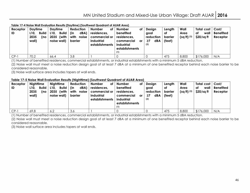
MN United Stadium and Mixed-Use Urban Village: Draft AUAR 2016
46
Table 17-4 Noise Wall Evaluation Results (Daytime) (Southwest Quadrant of AUAR Area) Receptor ID
Daytime L10, Build 2035 (no wall)
Daytime L10, Build 2035 (with noise wall)
Reduction (in dBA) with noise barrier
Number of residences, commercial or industrial establishments
Number of benefited residences, commercial or industrial establishments (1)
Design goal reduction ≥7 dBA (2)
Length of barrier (feet)
Wall Area (sq ft) (3)
Total cost of wall $20/sq ft
Cost/ Benefited Receptor
CP-1 70.2 66.4 3.8 1 0 0 475 8,800 $176,000 N/A (1) Number of benefited residences, commercial establishments, or industrial establishments with a minimum 5 dBA reduction. (2) Noise wall must meet a noise reduction design goal of at least 7 dBA at a minimum of one benefited receptor behind each noise barrier to be considered reasonable. (3) Noise wall surface area includes tapers at wall ends. Table 17-5 Noise Wall Evaluation Results (Nighttime) (Southwest Quadrant of AUAR Area) Receptor ID
Nighttime L10, Build 2035 (no wall)
Nighttime L10, Build 2035 (with noise wall)
Reduction (in dBA) with noise barrier
Number of residences, commercial or industrial establishments
Number of benefited residences, commercial or industrial establishments (1)
Design goal reduction ≥7 dBA (2)
Length of barrier (feet)
Wall Area (sq ft) (3)
Total cost of wall $20/sq ft
Cost/ Benefited Receptor
CP-1 69.8 6.2 3.6 1 0 0 475 8,800 $176,000 N/A (1) Number of benefited residences, commercial establishments, or industrial establishments with a minimum 5 dBA reduction. (2) Noise wall must meet a noise reduction design goal of at least 7 dBA at a minimum of one benefited receptor behind each noise barrier to be considered reasonable. (3) Noise wall surface area includes tapers at wall ends.
MN United Stadium and Mixed-Use Urban Village: Draft AUAR 2016
47
18. Transportation a. Describe traffic-related aspects of project construction and operation. Include: 1)
existing and proposed additional parking spaces, 2) estimated total average daily traffic generated, 3) estimated maximum peak hour traffic generated and time of occurrence, 4) indicate source of trip generation rates used in the estimates, and 5) availability of transit and/or other alternative transportation modes.
b. Discuss the effect on traffic congestion on affected roads and describe any traffic
improvements necessary. The analysis must discuss the project’s impact on the regional transportation system. If the peak hour traffic generated exceeds 250 vehicles or the total daily trips exceeds 2,500, a traffic impact study must be prepared as part of the EAW. Use the format and procedures described in the Minnesota Department of Transportation’s Access Management Manual, Chapter 5 (available at: http://www.dot.state.mn.us/accessmanagement/resources.html) or a similar local guidance,
c. Identify measures that will be taken to minimize or mitigate project related transportation effects.
The traffic analysis presented below is used for the responses to Items 15 (Vehicle-Related Air Emissions) and 17 with respect to Vehicle Noise. A transportation study was completed for the proposed soccer stadium and surrounding mixed-use development located in the southeast quadrant of the University Avenue/Snelling Avenue intersection in Saint Paul, Minnesota (see Figure 18-1: Project Location). The main objectives of this study were to review future traffic operations within the study area, evaluate development traffic impacts to the adjacent roadway network, including the proposed site access and internal circulation, evaluate transportation to and from stadium events, evaluate the transit and pedestrian/bike system, and recommend any necessary transportation improvements or operational considerations to accommodate the proposed developments. In general, assumptions made for purposes of this analysis were conservative, in particular with regard to transit clearance times and availability of nearby parking for stadium events. The full findings of the study are included as Appendix F to this AUAR. Analysis was completed for:
• Full Development (Master Plan) for Year 2035 o No Build and Build Conditions o Weekday AM and PM Peak Hour Traffic
• Soccer Stadium Event for Year of Opening in Year 2018 o Stadium capacity 20,000 o No new development o No Build and Build Conditions o Saturday 2:00 p.m. Start Time
Arrival Peak 1:00 to 2:00 p.m. Departure Peak 4:00 p.m. to 5:00 p.m.
• Soccer Stadium for Year 2035 o Stadium capacity 25,500
MN United Stadium and Mixed-Use Urban Village: Draft AUAR 2016
48
o Full Development based on the Master Plan o No Build and Build Conditions o Saturday 2:00 p.m. Start Time
Arrival Peak 1:00 to 2:00 p.m. Departure Peak 4:00 p.m. to 5:00 p.m.
The City of Saint Paul PED and Public Works, Ramsey County Public Works, Minnesota Department of Transportation, Metro Transit and FWHA met seven (7) times from January 28, 2016 to May 16, 2016 to discuss and coordinate elements of the transportation study.
Overall Transportation Analysis Inputs Data Collection
The existing traffic and pedestrian volumes were reviewed during eight (8) different time periods to establish a baseline in order to identify any future impacts associated with the proposed development and during expected soccer stadium event times.
Peak hour turning movement counts were collected during the following time periods and the locations shown in Figure 18-2: Data Collection Locations:
1. Weekday 7:30 a.m. to 8:30 a.m. 2. Weekday 4:45 p.m. to 5:45 p.m. 3. Weekday 6:00 p.m. to 7:00 p.m. 4. Weekday 9:00 p.m. to 10:00 p.m. 5. Saturday 1:00 p.m. to 2:00 p.m. 6. Saturday 4:00 p.m. to 5:00 p.m. 7. Saturday 6:00 p.m. to 7:00 p.m. 8. Saturday 9:00 p.m. to 10:00 p.m.
Traffic Forecasts To determine the operational impact of the proposed development, a no build scenario was analyzed using the year 2035 traffic volumes and existing geometrics. Traffic forecasts were developed for year 2035 no build conditions (proposed year of full build out for purpose of the study) using an annual background growth rate of one-half percent. The annual background growth rate is based on results from the Twin Cities Regional Travel Demand Model. This growth rate provides a conservative approach and is consistent with previous traffic studies done in the area. Intersection Evaluation Measurement Criteria The study intersections were analyzed using Synchro/SimTraffic (V9). Capacity analysis results identify a Level of Service (LOS), which indicates the quality of traffic flow through an intersection. Intersections are given a ranking from LOS A through LOS F. The LOS results are based on average delay per vehicle, which correspond to the delay threshold values shown in
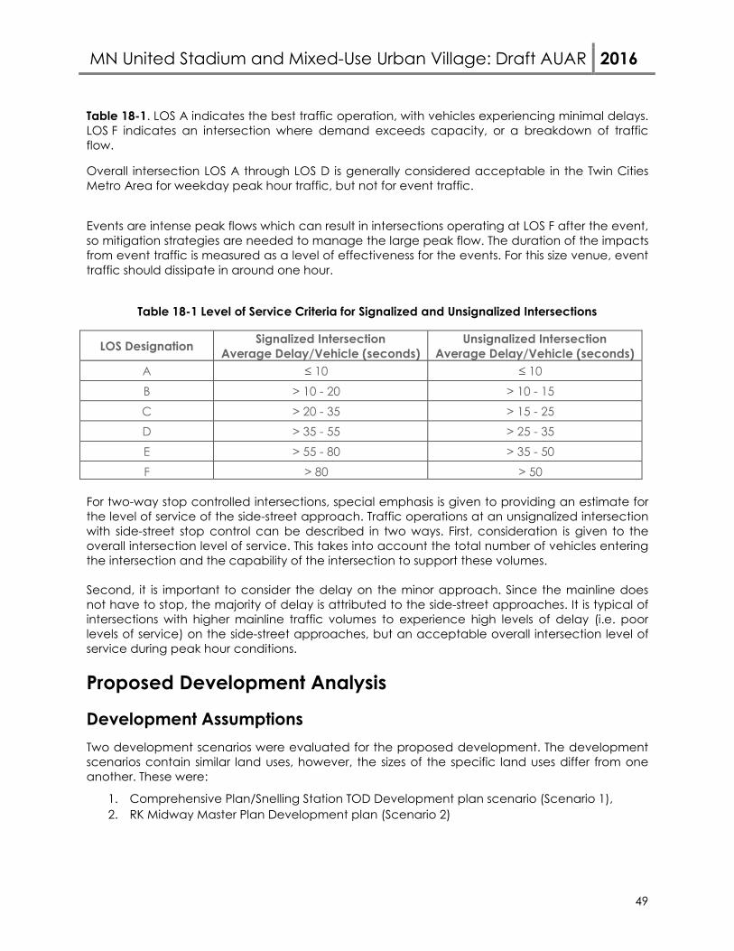
MN United Stadium and Mixed-Use Urban Village: Draft AUAR 2016
49
Table 18-1. LOS A indicates the best traffic operation, with vehicles experiencing minimal delays. LOS F indicates an intersection where demand exceeds capacity, or a breakdown of traffic flow.
Overall intersection LOS A through LOS D is generally considered acceptable in the Twin Cities Metro Area for weekday peak hour traffic, but not for event traffic.
Events are intense peak flows which can result in intersections operating at LOS F after the event, so mitigation strategies are needed to manage the large peak flow. The duration of the impacts from event traffic is measured as a level of effectiveness for the events. For this size venue, event traffic should dissipate in around one hour.
Table 18-1 Level of Service Criteria for Signalized and Unsignalized Intersections
LOS Designation Signalized Intersection Average Delay/Vehicle (seconds)
Unsignalized Intersection Average Delay/Vehicle (seconds)
A ≤ 10 ≤ 10 B > 10 - 20 > 10 - 15 C > 20 - 35 > 15 - 25 D > 35 - 55 > 25 - 35 E > 55 - 80 > 35 - 50 F > 80 > 50
For two-way stop controlled intersections, special emphasis is given to providing an estimate for the level of service of the side-street approach. Traffic operations at an unsignalized intersection with side-street stop control can be described in two ways. First, consideration is given to the overall intersection level of service. This takes into account the total number of vehicles entering the intersection and the capability of the intersection to support these volumes.
Second, it is important to consider the delay on the minor approach. Since the mainline does not have to stop, the majority of delay is attributed to the side-street approaches. It is typical of intersections with higher mainline traffic volumes to experience high levels of delay (i.e. poor levels of service) on the side-street approaches, but an acceptable overall intersection level of service during peak hour conditions.
Proposed Development Analysis
Development Assumptions Two development scenarios were evaluated for the proposed development. The development scenarios contain similar land uses, however, the sizes of the specific land uses differ from one another. These were:
1. Comprehensive Plan/Snelling Station TOD Development plan scenario (Scenario 1), 2. RK Midway Master Plan Development plan (Scenario 2)
MN United Stadium and Mixed-Use Urban Village: Draft AUAR 2016
50
In each plan the proposed development, there is a mixture of uses, including multi-family apartments, office, service retail type uses. In the RK Midway Master Plan, a 20,000 seat soccer stadium that is expandable to a capacity of 25,500 is also included. For purposes of this study, the proposed development was assumed to be fully operational by the year 2035. The soccer stadium is proposed to be completed by year 2018. The Comprehensive Plan/Snelling TOD development framework has been accepted by the city and will be compared to the proposed Master Plan. The development scenario with a higher intensity of trip generation was analyzed.
Access to the proposed development is proposed at the following locations in year 2035, shown in Figure 18-3. The access modifications and mitigation to the existing site include:
• Modifying access at the Snelling Avenue and Spruce Tree Avenue intersection to a right-in/right-out only and relocate the traffic signal to a new full intersection at Shields.
o This results in removal of the northbound and southbound left-turn lanes along Snelling Avenue. In conjunction, the northbound left-turn lane on Snelling Avenue at University Avenue is able to be lengthened.
• Constructing a westbound approach to the Shields Avenue and allowing for a full access intersection. It is expected that this intersection will become a signalized intersection under full build conditions.
o A southbound left-turn lane would be constructed at Shields Avenue. o Westbound geometry is expected to include a left-turn lane, a shared left-turn
and thru lane, and a right-turn lane. • Realigning access on Pascal Street to line-up across from access points to Walmart and
Cub. o Under full build conditions, there is potential that a traffic signal will be installed at
the site access point (extension of Shields) that aligns with the Walmart driveway.
Development Trip Generation In order to determine which development scenario would generate more external vehicle trips, a trip generation estimate for the proposed land uses in each plan was developed for the a.m. and p.m. weekday peak hours as well as a daily weekday basis. Trips are generated based on their land use sizes such as square footage, number of units, or seats. The trips are not generated based on the amount of parking spaces shown in the plans. Reductions were applied for trips between land uses (residential to retail) internal to the site, and for trips using other transportation modes besides a vehicle, and removal of the trips currently generated by the site.
Multi-Use reduction was developed based on the methodology within the ITE Trip Generation Manual, Ninth Edition and NCHRP Report 684: Enhancing Internal Trip Capture Estimation for Mixed-Use Developments. This accounts for a 10 percent multi-use reduction (internal trips) for the Comprehensive Plan/Snelling Station TOD Development Plan and 15 percent multi-use reduction for the RK Midway Master Plan Development Plan.
Mode share was completed using results from the Twin Cities Regional Model and the Ford Site Mode Share Methodology. This estimates the number of people who arrive and depart the site using car, walking, biking, LRT or Bus. The mode share can be influenced with the implementation of travel demand management (TDM) measures.
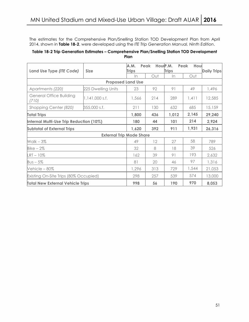
MN United Stadium and Mixed-Use Urban Village: Draft AUAR 2016
51
The estimates for the Comprehensive Plan/Snelling Station TOD Development Plan from April 2014, shown in Table 18-2, were developed using the ITE Trip Generation Manual, Ninth Edition.
Table 18-2 Trip Generation Estimates – Comprehensive Plan/Snelling Station TOD Development Plan
Land Use Type (ITE Code) Size A.M. Peak Hour Trips
P.M. Peak Hour Trips Daily Trips
In Out In Out Proposed Land Use
Apartments (220) 225 Dwelling Units 23 92 91 49 1,496 General Office Building (710) 1,141,000 s.f. 1,566 214 289 1,411 12,585
Shopping Center (820) 355,000 s.f. 211 130 632 685 15,159
Total Trips 1,800 436 1,012 2,145 29,240 Internal Multi-Use Trip Reduction (10%) 180 44 101 214 2,924 Subtotal of External Trips 1,620 392 911 1,931 26,316
External Trip Mode Share Walk – 3% 49 12 27 58 789 Bike – 2% 32 8 18 39 526 LRT – 10% 162 39 91 193 2,632 Bus – 5% 81 20 46 97 1,316 Vehicle – 80% 1,296 313 729 1,544 21,053
Existing On-Site Trips (80% Occupied) 298 257 539 574 13,000
Total New External Vehicle Trips 998 56 190 970 8,053

MN United Stadium and Mixed-Use Urban Village: Draft AUAR 2016
52
The estimates for the RK Midway Master Plan Development Plan from April 2016, shown in Table 18-3, were developed using the ITE Trip Generation Manual, Ninth Edition.
Table 18-3 Trip Generation Estimates – RK Midway Master Plan Development Plan
Land Use Type (ITE Code) Size A.M. Peak Hour Trips
P.M. Peak Hour Trips Daily Trips
In Out In Out Proposed Land Use
Apartments (220) 620 Dwelling Units 63 253 250 135 4,123 General Office Building (710) 1,000,000 s.f. 1,373 187 253 1,237 11,030
Shopping Center (820) 278,000 s.f. 165 101 495 536 11,871 Hotel (310) 400 rooms 125 87 122 118 3,268 Movie Theater (445) 800 Seats 0 0 23 41 1,000 Fitness Club (492) 50,000 s.f. 35 35 101 76 1,647 Supermarket (850) 42,000 s.f 89 54 203 195 4,294
Total Trips 1,850 717 1,447 2,338 37,233 Internal Multi-Use Trip Reduction (15%) 278 108 217 351 5,585 Subtotal of External Trips 1,572 609 1,230 1,987 31,648 External Trip Mode Share
Walk – 3% 47 18 37 60 949 Bike – 2% 31 12 25 40 633 LRT – 10% 157 61 123 199 3,165 Bus – 5% 79 31 62 99 1,582 Vehicle – 80% 1,258 488 984 1,589 25,318
Existing On-Site Trips (80% Occupied) 298 257 539 574 13,000
Total New External Vehicle Trips 960 231 445 1,015 12,318
Results of the trip generation estimates for Comprehensive Plan/Snelling Station TOD Development Plan indicate the proposed development is expected to generate a total of approximately 1,054 a.m. peak hour, 1,160 p.m. peak hour and 8,053 daily additional trips to the network, while the RK Midway Master Plan generates a total of approximately 1,191 a.m. peak hour, 1,460 p.m. peak hour and 12,318 daily additional trips to the network. The results trip generation comparison between the Comprehensive Plan/Snelling Station TOD Plan and the RK Midway Master Plan indicated that the RK Midway Master Plan is expected to generate 4,265 additional daily trips and slightly more peak hour trips than the Comprehensive Plan/Snelling Station TOD Plan, and therefore, will be utilized to complete future year 2035 build conditions.

MN United Stadium and Mixed-Use Urban Village: Draft AUAR 2016
53
Traffic Analysis – 2035 Development 2035 No Build Conditions – Weekday AM and PM Peak Hour
Results of the year 2035 No Build intersection capacity analysis shown in Table 18-4 indicate that all study intersections are expected to operate at an acceptable overall LOS D or better during the a.m. and p.m. peak hour with the existing roadway geometry and traffic controls, except for the Snelling Avenue and Selby Avenue intersection during the a.m. peak hour. It should be noted that optimized signal timing was assumed under future conditions. Additionally, access onto Snelling Avenue during the p.m. peak is expected to be difficult between I-94 and University Avenue and flow along Snelling Avenue south of the interchange is hindered by slower travel, high volumes and lane changing, however overall intersection LOS/delay is in the acceptable range.
During the p.m. peak hour, significant queuing is expected along Snelling Avenue between Concordia Avenue and Selby Avenue. While the overall intersection LOS is expected to remain at an acceptable overall LOS D, significant side-street delay is expected. These queuing and delay issues are a product of the significant eastbound right-turn from Concordia Avenue to southbound Snelling Avenue and the large southbound left-turn volume from Snelling Avenue to Selby Avenue. 2035 Build Conditions – Weekday AM and PM Peak Hour
Results of the year 2035 intersection capacity analysis shown in Table 18-5 indicate that all study intersections are expected to operate at an acceptable overall LOS D or better during the a.m. peak hour and p.m. peak hours with the new site access geometry and traffic controls, except for the Snelling Avenue and Selby Avenue intersection during the a.m. peak hour and the Hamline Avenue and Marshall Avenue intersection during the p.m. peak hour.
The poor operations of the Snelling Avenue and Selby Avenue intersection is a no-build condition with no proposed mitigation.
Poor operations are expected at the Hamline Avenue and Marshall Avenue intersection during the p.m. peak hour under the build condition. Based on preliminary analysis, providing an eastbound right-turn lane will improve to acceptable overall intersection operations. The improvement would require removing on-street parking stalls near the intersection, however, it may only be needed during the peak hours of the day.
During the p.m. peak hour, intersections on Snelling Avenue between Thomas Avenue and Selby Avenue are expected to operate at an overall LOS D, however, side-street queuing and delay is expected, similar to year 2035 no build conditions. A rolling type queue is expected along southbound Snelling Avenue. The newly constructed westbound approach of the Snelling Avenue and Shields Avenue intersection is expected to have maximum queues of over 750 feet, which will potentially extend into the on-site parking structures. The new trips generated by the development would be office trips, these trips are generally more regional and destined for the near-by freeways. Therefore, the queues on Snelling Avenue south of the I-94 interchange are relatively similar between no build and build conditions since build conditions are expected to add on a minimal amount of trips within this area.
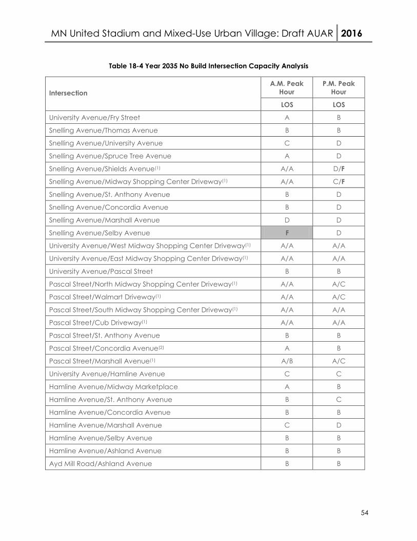
MN United Stadium and Mixed-Use Urban Village: Draft AUAR 2016
54
Table 18-4 Year 2035 No Build Intersection Capacity Analysis
Intersection A.M. Peak
Hour P.M. Peak
Hour
LOS LOS
University Avenue/Fry Street A B
Snelling Avenue/Thomas Avenue B B
Snelling Avenue/University Avenue C D
Snelling Avenue/Spruce Tree Avenue A D
Snelling Avenue/Shields Avenue(1) A/A D/F
Snelling Avenue/Midway Shopping Center Driveway(1) A/A C/F
Snelling Avenue/St. Anthony Avenue B D
Snelling Avenue/Concordia Avenue B D
Snelling Avenue/Marshall Avenue D D
Snelling Avenue/Selby Avenue F D
University Avenue/West Midway Shopping Center Driveway(1) A/A A/A
University Avenue/East Midway Shopping Center Driveway(1) A/A A/A
University Avenue/Pascal Street B B
Pascal Street/North Midway Shopping Center Driveway(1) A/A A/C
Pascal Street/Walmart Driveway(1) A/A A/C
Pascal Street/South Midway Shopping Center Driveway(1) A/A A/A
Pascal Street/Cub Driveway(1) A/A A/A
Pascal Street/St. Anthony Avenue B B
Pascal Street/Concordia Avenue(2) A B
Pascal Street/Marshall Avenue(1) A/B A/C
University Avenue/Hamline Avenue C C
Hamline Avenue/Midway Marketplace A B
Hamline Avenue/St. Anthony Avenue B C
Hamline Avenue/Concordia Avenue B B
Hamline Avenue/Marshall Avenue C D
Hamline Avenue/Selby Avenue B B
Hamline Avenue/Ashland Avenue B B
Ayd Mill Road/Ashland Avenue B B
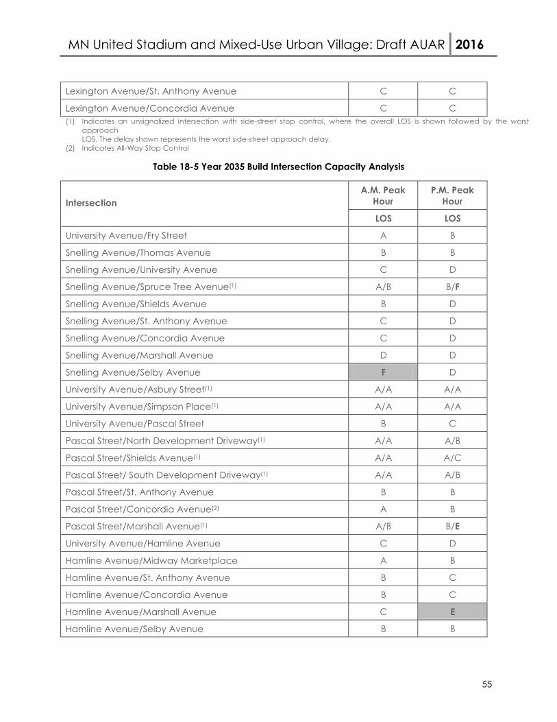
MN United Stadium and Mixed-Use Urban Village: Draft AUAR 2016
55
Lexington Avenue/St. Anthony Avenue C C
Lexington Avenue/Concordia Avenue C C (1) Indicates an unsignalized intersection with side-street stop control, where the overall LOS is shown followed by the worst
approach LOS. The delay shown represents the worst side-street approach delay.
(2) Indicates All-Way Stop Control
Table 18-5 Year 2035 Build Intersection Capacity Analysis
Intersection A.M. Peak
Hour P.M. Peak
Hour
LOS LOS
University Avenue/Fry Street A B
Snelling Avenue/Thomas Avenue B B
Snelling Avenue/University Avenue C D
Snelling Avenue/Spruce Tree Avenue(1) A/B B/F
Snelling Avenue/Shields Avenue B D
Snelling Avenue/St. Anthony Avenue C D
Snelling Avenue/Concordia Avenue C D
Snelling Avenue/Marshall Avenue D D
Snelling Avenue/Selby Avenue F D
University Avenue/Asbury Street(1) A/A A/A
University Avenue/Simpson Place(1) A/A A/A
University Avenue/Pascal Street B C
Pascal Street/North Development Driveway(1) A/A A/B
Pascal Street/Shields Avenue(1) A/A A/C
Pascal Street/ South Development Driveway(1) A/A A/B
Pascal Street/St. Anthony Avenue B B
Pascal Street/Concordia Avenue(2) A B
Pascal Street/Marshall Avenue(1) A/B B/E
University Avenue/Hamline Avenue C D
Hamline Avenue/Midway Marketplace A B
Hamline Avenue/St. Anthony Avenue B C
Hamline Avenue/Concordia Avenue B C
Hamline Avenue/Marshall Avenue C E
Hamline Avenue/Selby Avenue B B
MN United Stadium and Mixed-Use Urban Village: Draft AUAR 2016
56
Hamline Avenue/Ashland Avenue B C
Ayd Mill Road/Ashland Avenue B B
Lexington Avenue/St. Anthony Avenue C C
Lexington Avenue/Concordia Avenue D C
(1) Indicates an unsignalized intersection with side-street stop control, where the overall LOS is shown followed by the worst approach LOS. The delay shown represents the worst side-street approach delay.
(2) Indicates All-Way Stop Control
Key Findings for Full Build Development
1. To improve Snelling Avenue operations, the traffic signal at Spruce Tree Avenue should be relocated to Shields Avenue. This will require modifications/reconstruction of Snelling Avenue to Shields Avenue. Shields Avenue will need a larger westbound approach to accommodate the amount of traffic leaving the proposed office land use along Snelling.
2. Snelling Avenue will have intersections operating at acceptable LOS (delay) under the No Build and Build. However, while all intersections are expected to operate at LOS D from Shields Avenue to Selby Avenue, the high volume, queues, and lane changing south of the I-94 interchange makes the area feel congested under no build and build conditions.
3. The only intersection that goes from an acceptable LOS in No Build to an unacceptable LOS in Build is at Hamline Avenue and Marshall Avenue. Mitigation would not be required with the year of opening of the Stadium or initial development. Addition of an eastbound right-turn lane (by time of day with the removal of on-street parking) would provide acceptable overall level of service.
4. Traffic signal timing within the study area would need to be updated to accommodate future development traffic.
5. The proposer should encourage future land use to use the transit system with Green Line LRT, A-Line BRT and the other regular Metro Transit service adjacent to the site. Consider travel demand management (TDM) measures to encourage the use of these facilities.
Soccer Stadium Events As part of this environmental review, an analysis was conducted to address transportation issues related to the proposed soccer stadium. The proposed stadium is expected to have a capacity of 20,000 for the 2018 year of opening with the opportunity to expand to a capacity of 25,500 by year 2035. The soccer stadium is expected to open for the 2018 MLS season.
The assumptions for the analysis were based on conditions prior to implementing mitigation strategies and could change based on mitigation strategies that are implemented. This analysis was intended to identify potential issues that will require further investigation. These could be strategies to increase auto-occupancy, provide additional parking, provide staging areas for transit, or provide pre and post-game activities.
MN United Stadium and Mixed-Use Urban Village: Draft AUAR 2016
57
Traffic Analysis Event Assumptions Traffic volumes for the study area intersections were collected for events occurring on a weekday evening (7:00 p.m. start time), weekend afternoon (2:00 p.m. start time) and a weekend evening (7:00 p.m. start time). Typical matches last for approximately two hours. Based on a review of the traffic volumes collected, the weekend afternoon background volume was significantly higher than the other two scenarios. This is due to the retail peak that occurs on weekend afternoons. Therefore, the weekend afternoon peak scenario was selected for evaluation for worse-case conditions. Parking Availability An evaluation of on-site and adjacent off-site parking availability within a one mile walking distance was completed for both a year of opening and future year full-build out scenario for event parking. On-street parking is not a reliable source of event parking, and therefore was not included in this analysis as an option for meeting event parking needs. The goal of the transportation analysis was to determine mitigation strategies such that parking in adjacent residential neighborhoods is not needed to meet event demand. Similarly, accommodating event parking in nearby lots or ramps on can also be unreliable. The available parking supply was divided into parking on site and parking to the north, east, south, and west. The parking supply on site is expected to change between 2018 and 2035 with full development of the site. There are several adjacent (within one mile) off-site parking options surrounding the AUAR area. These are only potential options that may allow event parking and no contractual agreements are in place. These businesses may not want parking for various reasons including various reasons including already being used, not current practice, insurance, licensing and sales tax. Therefore, an assumption was made that only those spaces proposed as part of site or master plan and the 350 spaces for which the City has already verified availability would be available for event use. This study identified approximately 2,500 potential off-site spaces within one mile of the proposed stadium. Mode Split A specific mode split was completed for both year 2018 (Capacity 20,000 attendees) and year 2035 (Capacity 25,500 attendees) conditions. The mode split for fans at the proposed stadium is divided into five categories: Non-Auto, LRT or BRT (which includes walking from home, biking, and regular Metro Transit bus service), On-Site Parking, Off-Site Parking within walking distance of the site, Metro Transit’s LRT (Green Line)/BRT (A-Line), and Shuttles to off-site parking facilities. Auto Occupancy Based on prior experience with travel behavior characteristics for sports stadium around Twin Cities and around the country, it was estimated that 2.75 people per vehicle would be used as an average auto occupancy for all analysis time periods. Event Traffic Characteristics
It is assumed that not 100 percent of the event traffic is expected to arrive or depart the stadium area during the one-hour analysis periods. A certain percentage of attendees will arrive or depart outside of the analysis hours, depending on the time of day, available activities within the area, and day of the week. Table 18-6 shows the percent of vehicles arriving/departing during the analysis hour for each scenario. It is anticipated that the arrival peak will be smoother
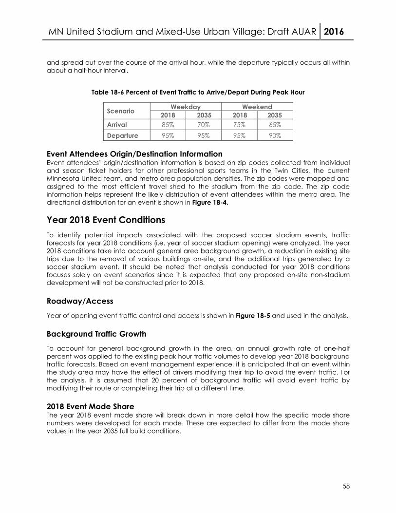
MN United Stadium and Mixed-Use Urban Village: Draft AUAR 2016
58
and spread out over the course of the arrival hour, while the departure typically occurs all within about a half-hour interval.
Table 18-6 Percent of Event Traffic to Arrive/Depart During Peak Hour
Scenario Weekday Weekend 2018 2035 2018 2035
Arrival 85% 70% 75% 65% Departure 95% 95% 95% 90%
Event Attendees Origin/Destination Information Event attendees’ origin/destination information is based on zip codes collected from individual and season ticket holders for other professional sports teams in the Twin Cities, the current Minnesota United team, and metro area population densities. The zip codes were mapped and assigned to the most efficient travel shed to the stadium from the zip code. The zip code information helps represent the likely distribution of event attendees within the metro area. The directional distribution for an event is shown in Figure 18-4.
Year 2018 Event Conditions To identify potential impacts associated with the proposed soccer stadium events, traffic forecasts for year 2018 conditions (i.e. year of soccer stadium opening) were analyzed. The year 2018 conditions take into account general area background growth, a reduction in existing site trips due to the removal of various buildings on-site, and the additional trips generated by a soccer stadium event. It should be noted that analysis conducted for year 2018 conditions focuses solely on event scenarios since it is expected that any proposed on-site non-stadium development will not be constructed prior to 2018. Roadway/Access
Year of opening event traffic control and access is shown in Figure 18-5 and used in the analysis. Background Traffic Growth
To account for general background growth in the area, an annual growth rate of one-half percent was applied to the existing peak hour traffic volumes to develop year 2018 background traffic forecasts. Based on event management experience, it is anticipated that an event within the study area may have the effect of drivers modifying their trip to avoid the event traffic. For the analysis, it is assumed that 20 percent of background traffic will avoid event traffic by modifying their route or completing their trip at a different time. 2018 Event Mode Share The year 2018 event mode share will break down in more detail how the specific mode share numbers were developed for each mode. These are expected to differ from the mode share values in the year 2035 full build conditions.
MN United Stadium and Mixed-Use Urban Village: Draft AUAR 2016
59
Walk/Bike/Local Bus/Private Shuttle The non-auto/LRT/BRT includes local bus service and people walking/biking to the event from their home or business. In order to determine the number of people walking to the site, an evaluation of the population of the metro was completed. This results in an estimate of about three percent of event attendees will walk to the event from their home or business. This number is expected to increase to five percent during weekend events due to increase in full families attending with potential guests. The potential biking share was estimated from bike usage at Minnesota Twins games. From this data, it was determined that approximately two percent of fans will utilize a bicycle trip to attend a match. The local bus service was evaluated to determine how many routes and number of trips are within the area. Based on this data, it was assumed that approximately one and half percent of fans will utilize existing transit service outside of LRT/BRT. Estimation on the usage of charter/private shuttle buses was completed. It was determined that 200 (one percent) fans on weekdays and 600 fans (three percent) on weekends will utilize charter buses. The team does have a fan base outside the metro area based on current ticket purchases. In addition to charter buses, local area private shuttle buses will bring fans to the match. It was assumed that on weekdays about 400 (two percent) fans will arrive via private shuttle, and on the weekends, up to 600 (three percent) fans. An additional 100 (half percent) fans may arrive via drop-off/pick-out (taxi or limo service) from other destinations. The combined total of these modes would accommodate 2,000 (10 percent) for a weekday match and 3,000 (15 percent) for a weekend match. On-Site Parking The on-site parking is expected to keep changing as development occurs. For year of opening, it is expected that approximately 400 vehicles may be able to park on-site, which will equate to approximately 1,100 fans or 5.5 percent of fans for a capacity event. Off-Site Adjacent Parking The off-site parking takes into account parking not on site, but within walking distance of the stadium. An assumption was made that a minimum of approximately 350 parking spaces, accommodating 1,000 fans, or 5 percent will be able to utilize off-site adjacent parking. This percentage could fluctuate depending on local area businesses’ desire to utilize their lots during events for parking. At this time, the City has verified the availability of 350 nearby off-street parking spaces for event use. LRT/BRT The LRT mode share was determined on available capacity of the LRT during the peak hours and the available crush load of approximately 540 people per three car train with the expected 10 minute headways. It was identified that with a full utilization of both the eastbound and

MN United Stadium and Mixed-Use Urban Village: Draft AUAR 2016
60
westbound LRT, approximately 6,200 fans or 31 percent will be able to utilize the LRT to arrive at the proposed stadium. The A-Line BRT is not operational until summer of 2016. Based on discussions with Metro Transit, there is an assumed crush load of 70 people within a BRT bus with 10 minute headways both directions during many of the events. Based on the crush load and expected occupancy of the BRT buses, approximately 700 attendees or three and half percent of event fans will be able to utilize the BRT. Shuttle Buses to Remote Parking The remaining event patrons would take another mode. The proposed mitigation strategy has been proposed to provide a shuttle service to off-site parking facilities. These “park–and-ride lots” are desired to be located within a two to three mile (20 to 30 minute round trip) radius. Ideally a limited number of strategic facilities would be identified. Based on the crush load and 115 to 130 bus trips, approximately 7,975 (weekend) to 8,975 (weekday) fans or 40 to 45 percent will utilize the shuttle bus service. Trip Generation
To account for traffic impacts associated with the proposed stadium development, trip generation estimates for weekend afternoon event (match starting at 2:00 p.m.) were developed. The high background traffic is generated by the near-by retail land uses, connections to other destinations and access to I-94. Any mitigation as a result of the weekend afternoon event is expected to alleviate traffic concerns during the other two potential soccer match times.
The capacity of the stadium is expected to be approximately 20,000 patrons in year 2018. The trip generation estimates, shown in Table 18-7 (person trips, not vehicle trips), were developed using the described mode share.
Table 18-7 Person Trip Generation Estimates – 20,000 Patrons
Modes Percent of Total
Weekday Percent of Total
Weekend Arrival Departure Arrival Departure
Non-Auto or LRT/BRT 10.0% 2,000 2,000 15.0% 3,000 3,000 On Site Parking 5.5% 1,100 1,100 5.5% 1,100 1,100 Off Site Parking 4.8% 965 965 4.8% 965 965 LRT/BRT 34.8% 6,960 6,960 34.8% 6,960 6,960 Off-Site Shuttles 44.9% 8,975 8,975 39.9% 7,975 7,975 Totals 100.0% 20,000 20,000 100.0% 20,000 20,000
Results of the trip generation estimates indicate that approximately 10 percent of trips for an event will occur using an automobile within the study area. A breakdown of the proposed person trip routes is shown in Figure 18-6.
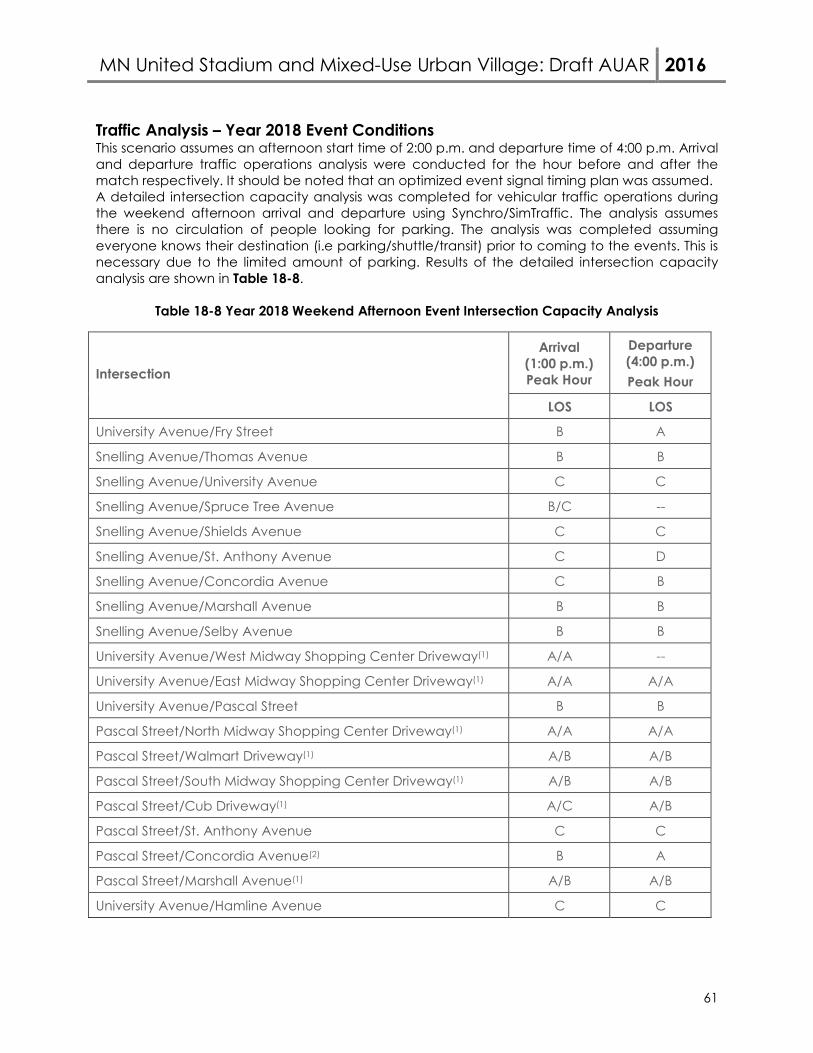
MN United Stadium and Mixed-Use Urban Village: Draft AUAR 2016
61
Traffic Analysis – Year 2018 Event Conditions This scenario assumes an afternoon start time of 2:00 p.m. and departure time of 4:00 p.m. Arrival and departure traffic operations analysis were conducted for the hour before and after the match respectively. It should be noted that an optimized event signal timing plan was assumed. A detailed intersection capacity analysis was completed for vehicular traffic operations during the weekend afternoon arrival and departure using Synchro/SimTraffic. The analysis assumes there is no circulation of people looking for parking. The analysis was completed assuming everyone knows their destination (i.e parking/shuttle/transit) prior to coming to the events. This is necessary due to the limited amount of parking. Results of the detailed intersection capacity analysis are shown in Table 18-8.
Table 18-8 Year 2018 Weekend Afternoon Event Intersection Capacity Analysis
Intersection
Arrival (1:00 p.m.) Peak Hour
Departure (4:00 p.m.) Peak Hour
LOS LOS
University Avenue/Fry Street B A
Snelling Avenue/Thomas Avenue B B
Snelling Avenue/University Avenue C C
Snelling Avenue/Spruce Tree Avenue B/C --
Snelling Avenue/Shields Avenue C C
Snelling Avenue/St. Anthony Avenue C D
Snelling Avenue/Concordia Avenue C B
Snelling Avenue/Marshall Avenue B B
Snelling Avenue/Selby Avenue B B
University Avenue/West Midway Shopping Center Driveway(1) A/A --
University Avenue/East Midway Shopping Center Driveway(1) A/A A/A
University Avenue/Pascal Street B B
Pascal Street/North Midway Shopping Center Driveway(1) A/A A/A
Pascal Street/Walmart Driveway(1) A/B A/B
Pascal Street/South Midway Shopping Center Driveway(1) A/B A/B
Pascal Street/Cub Driveway(1) A/C A/B
Pascal Street/St. Anthony Avenue C C
Pascal Street/Concordia Avenue(2) B A
Pascal Street/Marshall Avenue(1) A/B A/B
University Avenue/Hamline Avenue C C
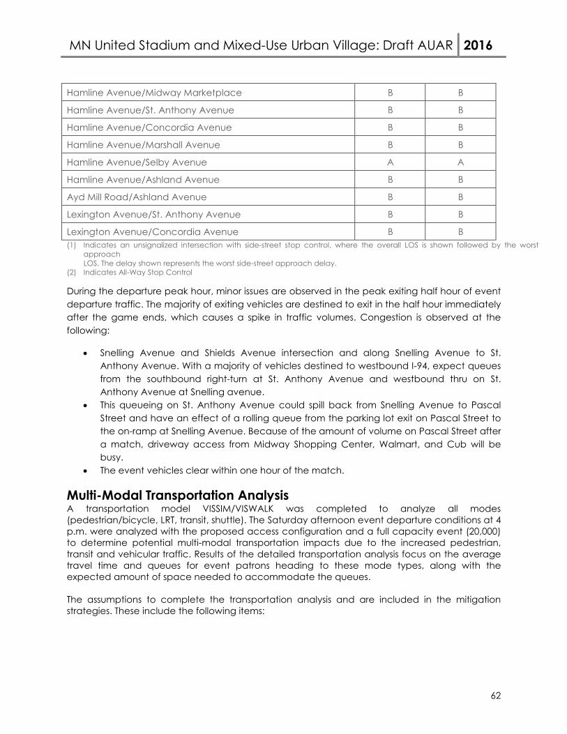
MN United Stadium and Mixed-Use Urban Village: Draft AUAR 2016
62
Hamline Avenue/Midway Marketplace B B
Hamline Avenue/St. Anthony Avenue B B
Hamline Avenue/Concordia Avenue B B
Hamline Avenue/Marshall Avenue B B
Hamline Avenue/Selby Avenue A A
Hamline Avenue/Ashland Avenue B B
Ayd Mill Road/Ashland Avenue B B
Lexington Avenue/St. Anthony Avenue B B
Lexington Avenue/Concordia Avenue B B (1) Indicates an unsignalized intersection with side-street stop control, where the overall LOS is shown followed by the worst
approach LOS. The delay shown represents the worst side-street approach delay.
(2) Indicates All-Way Stop Control
During the departure peak hour, minor issues are observed in the peak exiting half hour of event departure traffic. The majority of exiting vehicles are destined to exit in the half hour immediately after the game ends, which causes a spike in traffic volumes. Congestion is observed at the following:
• Snelling Avenue and Shields Avenue intersection and along Snelling Avenue to St. Anthony Avenue. With a majority of vehicles destined to westbound I-94, expect queues from the southbound right-turn at St. Anthony Avenue and westbound thru on St. Anthony Avenue at Snelling avenue.
• This queueing on St. Anthony Avenue could spill back from Snelling Avenue to Pascal Street and have an effect of a rolling queue from the parking lot exit on Pascal Street to the on-ramp at Snelling Avenue. Because of the amount of volume on Pascal Street after a match, driveway access from Midway Shopping Center, Walmart, and Cub will be busy.
• The event vehicles clear within one hour of the match.
Multi-Modal Transportation Analysis A transportation model VISSIM/VISWALK was completed to analyze all modes (pedestrian/bicycle, LRT, transit, shuttle). The Saturday afternoon event departure conditions at 4 p.m. were analyzed with the proposed access configuration and a full capacity event (20,000) to determine potential multi-modal transportation impacts due to the increased pedestrian, transit and vehicular traffic. Results of the detailed transportation analysis focus on the average travel time and queues for event patrons heading to these mode types, along with the expected amount of space needed to accommodate the queues. The assumptions to complete the transportation analysis and are included in the mitigation strategies. These include the following items:
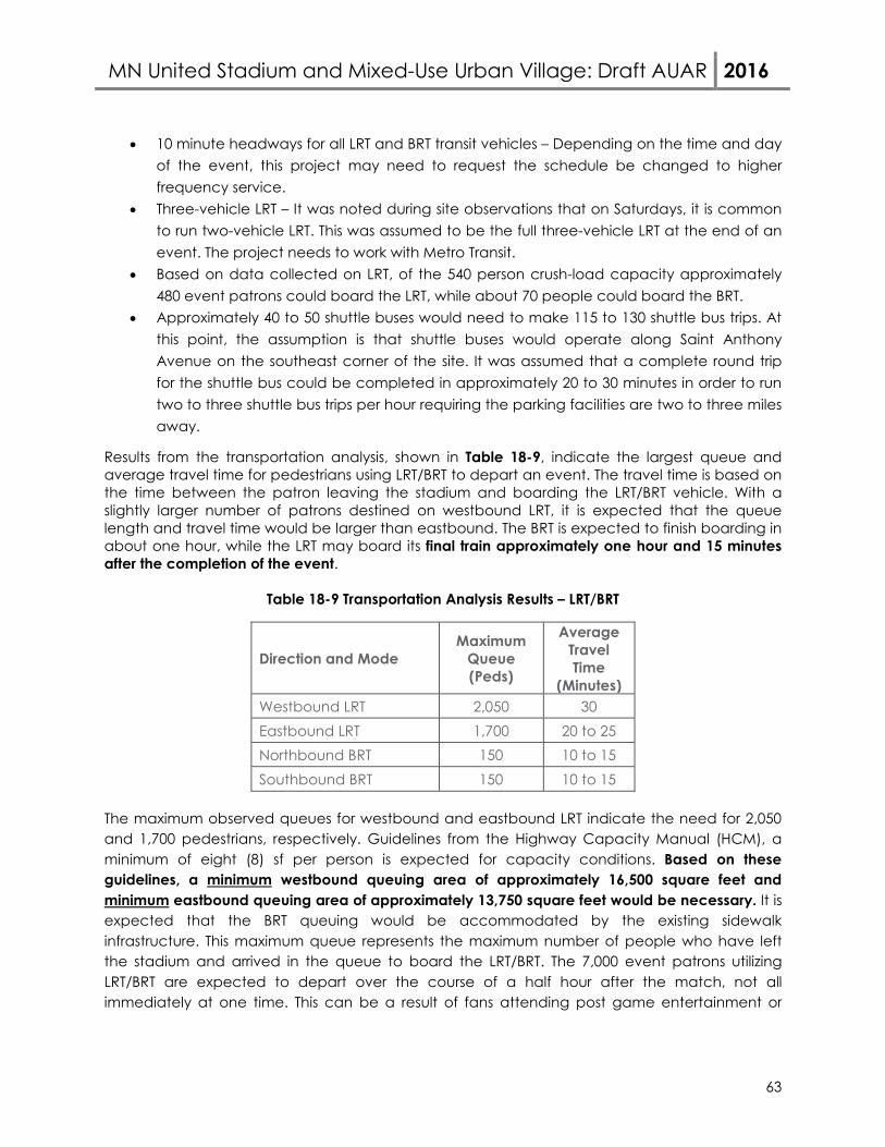
MN United Stadium and Mixed-Use Urban Village: Draft AUAR 2016
63
• 10 minute headways for all LRT and BRT transit vehicles – Depending on the time and day of the event, this project may need to request the schedule be changed to higher frequency service.
• Three-vehicle LRT – It was noted during site observations that on Saturdays, it is common to run two-vehicle LRT. This was assumed to be the full three-vehicle LRT at the end of an event. The project needs to work with Metro Transit.
• Based on data collected on LRT, of the 540 person crush-load capacity approximately 480 event patrons could board the LRT, while about 70 people could board the BRT.
• Approximately 40 to 50 shuttle buses would need to make 115 to 130 shuttle bus trips. At this point, the assumption is that shuttle buses would operate along Saint Anthony Avenue on the southeast corner of the site. It was assumed that a complete round trip for the shuttle bus could be completed in approximately 20 to 30 minutes in order to run two to three shuttle bus trips per hour requiring the parking facilities are two to three miles away.
Results from the transportation analysis, shown in Table 18-9, indicate the largest queue and average travel time for pedestrians using LRT/BRT to depart an event. The travel time is based on the time between the patron leaving the stadium and boarding the LRT/BRT vehicle. With a slightly larger number of patrons destined on westbound LRT, it is expected that the queue length and travel time would be larger than eastbound. The BRT is expected to finish boarding in about one hour, while the LRT may board its final train approximately one hour and 15 minutes after the completion of the event.
Table 18-9 Transportation Analysis Results – LRT/BRT
Direction and Mode Maximum
Queue (Peds)
Average Travel Time
(Minutes) Westbound LRT 2,050 30 Eastbound LRT 1,700 20 to 25 Northbound BRT 150 10 to 15 Southbound BRT 150 10 to 15
The maximum observed queues for westbound and eastbound LRT indicate the need for 2,050 and 1,700 pedestrians, respectively. Guidelines from the Highway Capacity Manual (HCM), a minimum of eight (8) sf per person is expected for capacity conditions. Based on these guidelines, a minimum westbound queuing area of approximately 16,500 square feet and minimum eastbound queuing area of approximately 13,750 square feet would be necessary. It is expected that the BRT queuing would be accommodated by the existing sidewalk infrastructure. This maximum queue represents the maximum number of people who have left the stadium and arrived in the queue to board the LRT/BRT. The 7,000 event patrons utilizing LRT/BRT are expected to depart over the course of a half hour after the match, not all immediately at one time. This can be a result of fans attending post game entertainment or
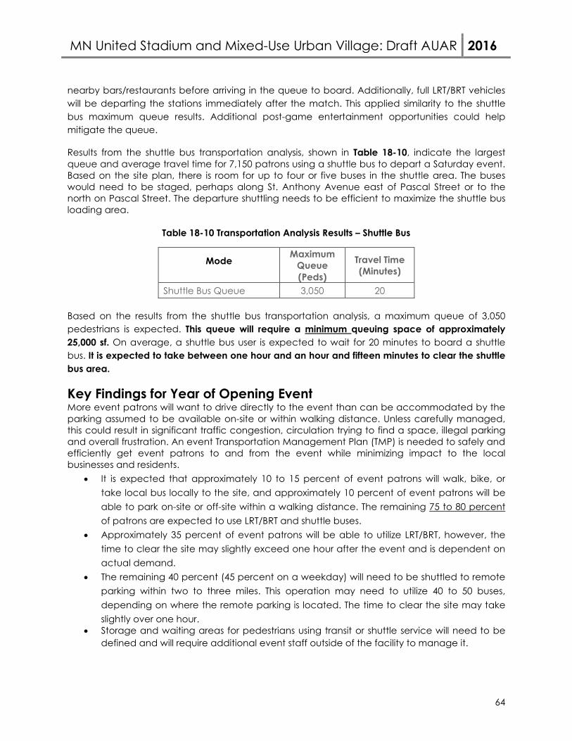
MN United Stadium and Mixed-Use Urban Village: Draft AUAR 2016
64
nearby bars/restaurants before arriving in the queue to board. Additionally, full LRT/BRT vehicles will be departing the stations immediately after the match. This applied similarity to the shuttle bus maximum queue results. Additional post-game entertainment opportunities could help mitigate the queue.
Results from the shuttle bus transportation analysis, shown in Table 18-10, indicate the largest queue and average travel time for 7,150 patrons using a shuttle bus to depart a Saturday event. Based on the site plan, there is room for up to four or five buses in the shuttle area. The buses would need to be staged, perhaps along St. Anthony Avenue east of Pascal Street or to the north on Pascal Street. The departure shuttling needs to be efficient to maximize the shuttle bus loading area.
Table 18-10 Transportation Analysis Results – Shuttle Bus
Mode Maximum
Queue (Peds)
Travel Time (Minutes)
Shuttle Bus Queue 3,050 20
Based on the results from the shuttle bus transportation analysis, a maximum queue of 3,050 pedestrians is expected. This queue will require a minimum queuing space of approximately 25,000 sf. On average, a shuttle bus user is expected to wait for 20 minutes to board a shuttle bus. It is expected to take between one hour and an hour and fifteen minutes to clear the shuttle bus area.
Key Findings for Year of Opening Event More event patrons will want to drive directly to the event than can be accommodated by the parking assumed to be available on-site or within walking distance. Unless carefully managed, this could result in significant traffic congestion, circulation trying to find a space, illegal parking and overall frustration. An event Transportation Management Plan (TMP) is needed to safely and efficiently get event patrons to and from the event while minimizing impact to the local businesses and residents.
• It is expected that approximately 10 to 15 percent of event patrons will walk, bike, or take local bus locally to the site, and approximately 10 percent of event patrons will be able to park on-site or off-site within a walking distance. The remaining 75 to 80 percent of patrons are expected to use LRT/BRT and shuttle buses.
• Approximately 35 percent of event patrons will be able to utilize LRT/BRT, however, the time to clear the site may slightly exceed one hour after the event and is dependent on actual demand.
• The remaining 40 percent (45 percent on a weekday) will need to be shuttled to remote parking within two to three miles. This operation may need to utilize 40 to 50 buses, depending on where the remote parking is located. The time to clear the site may take slightly over one hour.
• Storage and waiting areas for pedestrians using transit or shuttle service will need to be defined and will require additional event staff outside of the facility to manage it.

MN United Stadium and Mixed-Use Urban Village: Draft AUAR 2016
65
• Based on Highway Capacity Manual guidelines, a minimum westbound LRT queueing area of approximately 16,500 square feet and minimum eastbound LRT queueing area of approximately 13,750 square feet would be necessary. The shuttle bus pedestrian queue will require a minimum queuing space of approximately 25,000 sf. Both of these queues are expected to take just over one hour to clear out.
• The I-94/Snelling interchange is a key vehicular bottleneck in the system. Event patrons should be encouraged to use adjacent interchanges when arriving and departing the event. Shuttle bus service along Saint Anthony may need to be reconsidered because of this bottleneck.
• The area has a significant amount of retail land use. Weekend events starting between 1:00 p.m. and 5:00 p.m. and ending between 3:00 p.m. and 7:00 p.m. place the event traffic during the busiest business times and background traffic. Capacity events should be encouraged for a 7:00/7:30 p.m. start time with departure at 9:00/9:30 p.m.
Year 2035 Event Conditions To identify potential impacts associated with the proposed soccer stadium events under full build conditions, traffic forecasts for year 2035 conditions (i.e. year of full build of adjacent development) were reviewed. The year 2035 conditions take into account general area background growth, trips generated by the adjacent buildings on the proposed site, and the additional trips generated by a soccer stadium event. The proposed soccer stadium has the potential to expand to a capacity of 25,500 by the year 2035, therefore, this analysis will consider this larger event attendance in addition to the adjacent development.
Roadway/Access
Year of opening event traffic control and access is shown in Figure 18-7 and used in the analysis. Background Traffic Growth
To account for general background growth in the area, an annual growth rate of one-half percent was applied to the existing peak hour traffic volumes to develop year 2035 background traffic forecasts. Based on event management experience, it is anticipated that an event within the study area may have the effect of drivers modifying their trip to avoid the event traffic. For the analysis, it is assumed that 20 percent of background traffic will avoid event traffic by modifying their route or completing their trip at a different time. 2035 Event Mode Share The year 2035 event mode share will break down in more detail how the specific mode share numbers were developed for each mode. Walk/Bike/Local Bus/Private Shuttle The non-auto/LRT/BRT includes local bus service and people walking/biking to the event from their home or business. In order to determine the number of people walking to the site, an evaluation of the population of the metro was completed. This results in an estimate of about four percent of event attendees will walk to the event from their home or business. This number is expected to increase to six percent during weekend events due to increase in full families attending with potential guests.
MN United Stadium and Mixed-Use Urban Village: Draft AUAR 2016
66
With the new development expected on site near the stadium, it is expected that a portion of these workers, residents, and hotel visitors will attend a match. During a weekday and weekend, it is assumed that approximately 800 fans (three percent) of the total attendance could come from people already on site. The potential biking share was estimated from bike usage at Minnesota Twins games. From this data, it was determined that approximately two percent of fans will utilize a bicycle trip to attend a match. The local bus service was evaluated to determine how many routes and number of trips are within the area. Based on this data, it was assumed that approximately two percent of fans will utilize existing transit service outside of LRT/BRT. Estimation on the usage of charter/private shuttle buses was completed. It was determined that 200 (one percent) fans on weekdays and 600 fans (three percent) on weekends will utilize charter buses. The team does have a fan base outside the metro area based on current ticket purchases. In addition to charter buses, local area private shuttle buses will bring fans to the match. It was assumed that on weekdays about 400 (two percent) fans will arrive via private shuttle, and on the weekends, up to 600 (three percent) fans. An additional 100 (half percent) fans may arrive via drop-off/pick-out (taxi or limo service) from other destinations. The combined total of these modes would accommodate 3,500 (14 percent) for a weekday match and 4,600 (18 percent) for a weekend match. On-Site Parking The on-site parking is expected to keep changing as development occurs. For year of opening, it is expected that approximately 2,050 vehicles may be able to park on-site, which will equate to approximately 5,650 fans or 22 percent of fans for a capacity event. This parking plan is considered preliminary as future discussions with office tenants on site will be necessary to discuss available game day parking on weekdays and weekends. Off-Site Adjacent Parking The off-site parking takes into account parking not on site, but within walking distance of the stadium. An assumption was made that a minimum of approximately 350 parking spaces, accommodating 1,000 fans, or 4.5 percent will be able to utilize off-site adjacent parking. This percentage could fluctuate depending on local area businesses’ desire to utilize their lots during events for parking. No commitments have been made by off-site business, nor does the team or city control any of this parking. LRT/BRT The LRT mode share was determined on available capacity of the LRT during the peak hours and the available crush load of approximately 540 people per three car train with the expected 10 minute headways. It was identified that with a full utilization of both the eastbound and westbound LRT, approximately 6,200 fans or 24 percent will be able to utilize the LRT to arrive at the proposed stadium. The A-Line BRT is not operational until summer of 2016. Based on discussions with Metro Transit, there is an assumed crush load of 70 people within a BRT bus with 10 minute headways both
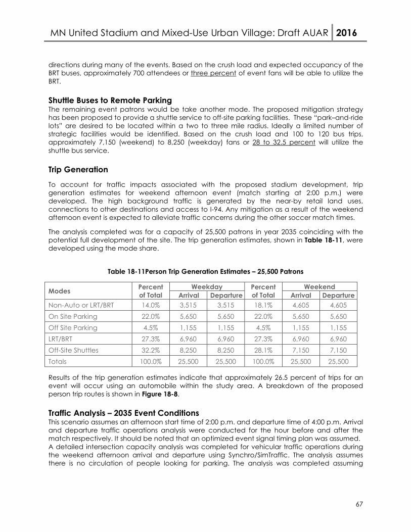
MN United Stadium and Mixed-Use Urban Village: Draft AUAR 2016
67
directions during many of the events. Based on the crush load and expected occupancy of the BRT buses, approximately 700 attendees or three percent of event fans will be able to utilize the BRT. Shuttle Buses to Remote Parking The remaining event patrons would be take another mode. The proposed mitigation strategy has been proposed to provide a shuttle service to off-site parking facilities. These “park–and-ride lots” are desired to be located within a two to three mile radius. Ideally a limited number of strategic facilities would be identified. Based on the crush load and 100 to 120 bus trips, approximately 7,150 (weekend) to 8,250 (weekday) fans or 28 to 32.5 percent will utilize the shuttle bus service. Trip Generation
To account for traffic impacts associated with the proposed stadium development, trip generation estimates for weekend afternoon event (match starting at 2:00 p.m.) were developed. The high background traffic is generated by the near-by retail land uses, connections to other destinations and access to I-94. Any mitigation as a result of the weekend afternoon event is expected to alleviate traffic concerns during the other soccer match times.
The analysis completed was for a capacity of 25,500 patrons in year 2035 coinciding with the potential full development of the site. The trip generation estimates, shown in Table 18-11, were developed using the mode share.
Table 18-11Person Trip Generation Estimates – 25,500 Patrons
Modes Percent of Total
Weekday Percent of Total
Weekend Arrival Departure Arrival Departure
Non-Auto or LRT/BRT 14.0% 3,515 3,515 18.1% 4,605 4,605 On Site Parking 22.0% 5,650 5,650 22.0% 5,650 5,650 Off Site Parking 4.5% 1,155 1,155 4.5% 1,155 1,155 LRT/BRT 27.3% 6,960 6,960 27.3% 6,960 6,960 Off-Site Shuttles 32.2% 8,250 8,250 28.1% 7,150 7,150 Totals 100.0% 25,500 25,500 100.0% 25,500 25,500
Results of the trip generation estimates indicate that approximately 26.5 percent of trips for an event will occur using an automobile within the study area. A breakdown of the proposed person trip routes is shown in Figure 18-8. Traffic Analysis – 2035 Event Conditions This scenario assumes an afternoon start time of 2:00 p.m. and departure time of 4:00 p.m. Arrival and departure traffic operations analysis were conducted for the hour before and after the match respectively. It should be noted that an optimized event signal timing plan was assumed. A detailed intersection capacity analysis was completed for vehicular traffic operations during the weekend afternoon arrival and departure using Synchro/SimTraffic. The analysis assumes there is no circulation of people looking for parking. The analysis was completed assuming
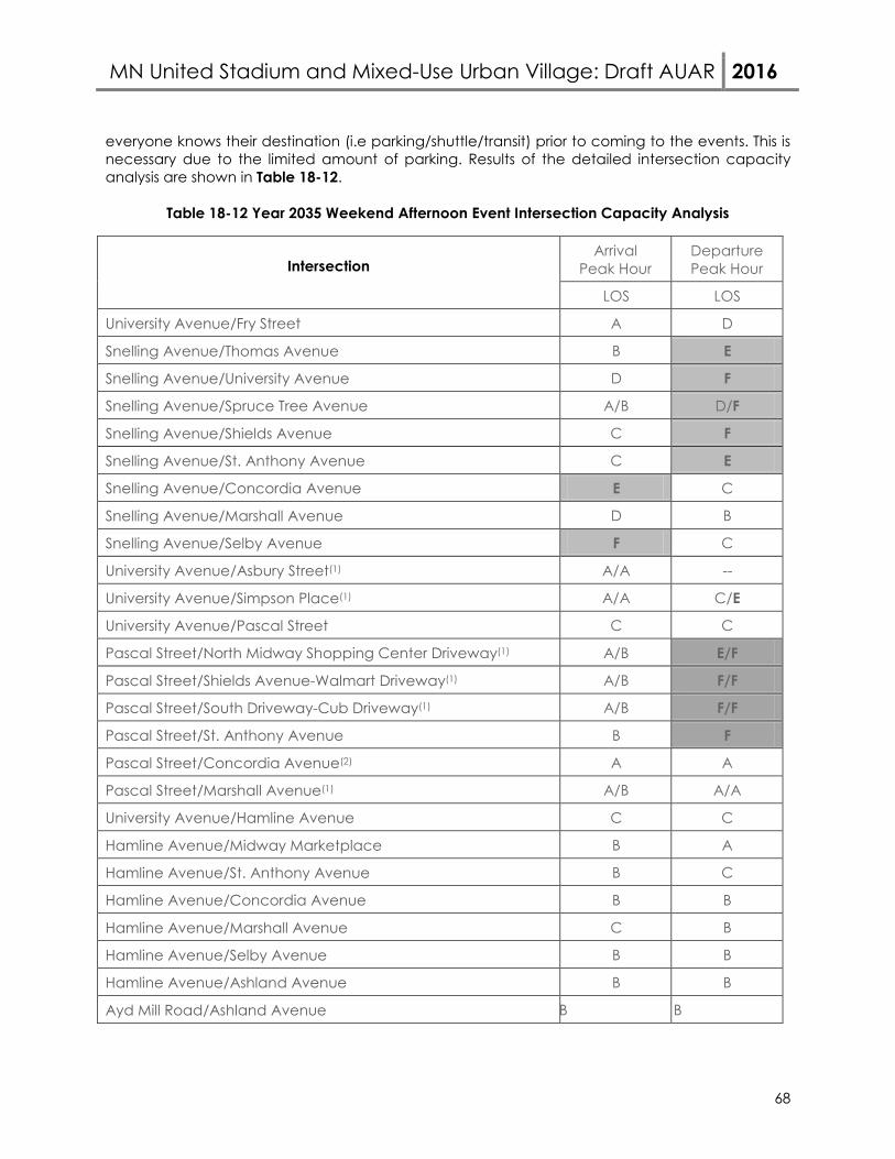
MN United Stadium and Mixed-Use Urban Village: Draft AUAR 2016
68
everyone knows their destination (i.e parking/shuttle/transit) prior to coming to the events. This is necessary due to the limited amount of parking. Results of the detailed intersection capacity analysis are shown in Table 18-12.
Table 18-12 Year 2035 Weekend Afternoon Event Intersection Capacity Analysis
Intersection Arrival
Peak Hour Departure Peak Hour
LOS LOS
University Avenue/Fry Street A D
Snelling Avenue/Thomas Avenue B E
Snelling Avenue/University Avenue D F
Snelling Avenue/Spruce Tree Avenue A/B D/F
Snelling Avenue/Shields Avenue C F
Snelling Avenue/St. Anthony Avenue C E
Snelling Avenue/Concordia Avenue E C
Snelling Avenue/Marshall Avenue D B
Snelling Avenue/Selby Avenue F C
University Avenue/Asbury Street(1) A/A --
University Avenue/Simpson Place(1) A/A C/E
University Avenue/Pascal Street C C
Pascal Street/North Midway Shopping Center Driveway(1) A/B E/F
Pascal Street/Shields Avenue-Walmart Driveway(1) A/B F/F
Pascal Street/South Driveway-Cub Driveway(1) A/B F/F
Pascal Street/St. Anthony Avenue B F
Pascal Street/Concordia Avenue(2) A A
Pascal Street/Marshall Avenue(1) A/B A/A
University Avenue/Hamline Avenue C C
Hamline Avenue/Midway Marketplace B A
Hamline Avenue/St. Anthony Avenue B C
Hamline Avenue/Concordia Avenue B B
Hamline Avenue/Marshall Avenue C B
Hamline Avenue/Selby Avenue B B
Hamline Avenue/Ashland Avenue B B
Ayd Mill Road/Ashland Avenue B B

MN United Stadium and Mixed-Use Urban Village: Draft AUAR 2016
69
Lexington Avenue/St. Anthony Avenue B B
Lexington Avenue/Concordia Avenue B B (1) Indicates an unsignalized intersection with side-street stop control, where the overall LOS is shown followed by the worst
approach LOS. The delay shown represents the worst side-street approach delay.
(2) Indicates All-Way Stop Control
During the arrival peak hour on a weekend afternoon, there is expected to be queuing in the northbound direction of Snelling Avenue from south of Selby Avenue to the I-94 interchange. This is due to the significant eastbound left-turning volume at Snelling Avenue and Concordia Avenue intersection coming from I-94 heading to the on-site event parking lot along Snelling Avenue. In addition to causing significant queuing, the overall LOS is expected to be an overall LOS E at the Snelling Avenue and Concordia Avenue intersection and an overall LOS F at the Snelling Avenue and Selby Avenue intersection.
During the departure peak hour, issues are observed over the course of the peak hour for vehicular traffic. This is observed at the Snelling Avenue and Shields Avenue intersection and along the driveways on Pascal Street. Traffic volumes during the exiting peak hour are large along Snelling Avenue and Saint Anthony, with much of the traffic destined to the westbound I-94 on-ramp. This queueing on St. Anthony Avenue could spill back from Snelling Avenue to Pascal Street and have an effect of a rolling queue from the parking lot exits on Pascal Street. This queuing along St. Anthony Avenue is also expected to have a major impact on the shuttle bus pick-up and drop-off area. The on-site vehicular traffic is expected to take approximately one and a half to two hours to clear.
Key Findings for Year 2035 Capacity Event Additional findings beyond those for year of opening (2018):
• The site will continue to change as re-development occurs. An updated TMP should be prepared each year to account for the changes.
• The additional on-site parking, all located along Snelling Avenue departing at one access point, is challenging. The on-site parking will require almost two hours to clear.
• Additional parking should be found away from the site and have good access to the other interchanges to I-94, not Snelling Avenue.
• In order to clear event traffic in one hour (besides on-site vehicles), additional shuttle bus service will be needed. Although, it is expected that the new residential uses, office, and hotel will result in more event patrons walking to the event.
• Weekend start times should be even more encouraged to start later in the day (after 7:00 p.m.), although the significant amount of vehicles departing from the site at Shields Avenue after an event will be problematic at any time.
• Issues are expected along Snelling Avenue during both the arrival and departure peak hours.
o During arrivals, the event eastbound left-turning volume at the Concordia Avenue/Snelling Avenue intersection is expected to back-up onto the Snelling Avenue exit ramp. The northbound direction of Snelling Avenue queues between Concordia Avenue and Selby Avenue. Typically, other sporting event arrivals in the Twin Cities do not result in such poor operations.
MN United Stadium and Mixed-Use Urban Village: Draft AUAR 2016
70
o During the departure peak hour, significant issues are expected exiting the site through the Snelling Avenue and Shields Avenue intersection. With the majority of these vehicles destined to I-94 westbound, the Snelling Avenue and St. Anthony Avenue intersection is expected to be over capacity and will not be able to accommodate all of the event traffic within one hour. It is expected to take almost two full hours to clear event traffic from the site.
o These event departure issues along Snelling Avenue could impact the shuttle bus pick-up area along St. Anthony Avenue.
o These potential traffic issues will need to be evaluated with any expansion plans in the future with better understanding of the actual event experience at this site.
Mitigation Strategies This section relates to mitigation needed based on the re-development of the entire site and not related to traffic generated by an event at the soccer stadium. It is important to remember that the proposed plan has just a slight increase in the amount of retail space compared to the existing site. The retail trips are more local in nature. The site does propose new office space of around 1 million square feet. These trips are typically more regional. Completion of full development At the completion of full development, the new improvements should include the following: Internal roadway system connections to public roadways:
1. Two internal north-south roadways that connect to University Avenue (partial access; right-in/right-out only) and the easterly north-south roadway connecting to Saint Anthony as a right-in/right-out access and western north-south roadway terminating in the site.
2. Two east-west roadways that connect Snelling Avenue and Pascal Street a. Extension of Spruce Tree would have modified access resulting in right-in/right-out
only movements with the traffic signal removed at Snelling Avenue and full access at Pascal Street
b. Extension of Shields Avenue would result in a new full access signalized access at Shields Avenue and full access with potential of a traffic signal at Pascal Street
Pedestrian and bike accommodations internal to the site
Around the Site 3. Pedestrian sidewalk should be provided around the perimeter of the site, with a minimum
width of eight feet. 4. Bike racks for a minimum of 400 bicycles should be provided.
Snelling Avenue – University Avenue to Shields Avenue
To address the close spacing of the Spruce Tree and University Avenue intersection; 5. Spruce Tree intersection
a. Add a center median to only allow right-in/right-only access b. Remove the traffic signal (“relocated” to Shields Avenue)
6. University Avenue Intersection a. Extend Northbound left-turn lane from 50 feet to 250 feet
MN United Stadium and Mixed-Use Urban Village: Draft AUAR 2016
71
7. Shields Avenue a. New traffic signal (“relocated” from Spruce Tree Avenue) b. Add Southbound left-turn lane c. Two-lanes of approach for eastbound Shields Avenue (check alignment across
intersection); left-thru lane and a right-turn lane d. Three-lanes of approach for Westbound Shields Avenue with two providing left-
turn movements; left-turn lane, left-thru lane and right turn lane e. Traffic signal phasing can vary throughout the time of day, depending on traffic
volume demand. It is expected that the new signal controller and signal heads will be able to accommodate both phasing options presented:
i. Westbound protected/permissive (i.e flashing yellow arrow) left-turn phasing with no eastbound left-turn phasing (more efficient)
1. Best operation with an assumed 20 foot wide pedestrian crossing only on the north side
2. This option is recommended to be run during all peak hours ii. Split Phasing
1. Pedestrian crossing only on the north side 2. This may be run in off peak times
Pascal Street – University Avenue to Saint Anthony
With the new land use; access points should align across Pascal and left-turn lanes provided. 8. Shields Extension – New traffic signal (when warranted) 9. Re-stripe Pascal to provide a three-lane roadway (one thru lane in each direction with
left-turn lane) with the additional space as a bike-lane or shoulder. Maintain Northbound left-turn lane at University Avenue and add Southbound right-turn lane at Saint Anthony
10. Sufficient width and right-of-way should be obtained to provide a five-lane roadway if needed in the future.
11. Saint Anthony – Install a permanent traffic control signal
Marshall Avenue / Hamline Avenue Intersection
The site does not generate much traffic going through this intersection, but enough to cause the intersection to be unacceptable. The operations can be mitigated with two solutions:
12. Add an Eastbound right-turn lane during the PM Peak Hour by restricting 100 feet of parking along Marshall Avenue.
a. Alternative would be to add Northbound and Southbound left-turn lanes. b. This improvement is not needed with the initial development phases.
Snelling Avenue from University Avenue to Selby Avenue
The expected additional development generated traffic is expected to be a small increase south of the I-94 interchange, we know that today eastbound queues can somedays back from the I-94 eastbound ramp intersection onto the freeway due to southbound queuing on Snelling Avenue. Snelling Avenue south of the interchange can feel congested with the number of vehicles changing lanes to Selby Avenue and queues blocking unsignalized intersections during the peaks.
MN United Stadium and Mixed-Use Urban Village: Draft AUAR 2016
72
13. Update traffic signal timing along Snelling Avenue for the six intersections for each phase
of development.
Policy Measures
Encourage use of Transit The site is served by great transit facilities with Central Corridor LRT (Green Line) along University Avenue and a new BRT (Bus Rapid Transit) “A-Line” starting in summer of 2016.
14. Consider implementing TDMP (Travel Demand Management Plan) strategies with future re-development
15. Land use guidance to promote TOD (Transit Orientated Developed) and complementary land uses
Mitigation – Event (Year of Opening 2018 – Capacity of 20,000)
Mitigating an event requires a management strategy and elements of that strategy. Based on the modeling of the events, the following items are needed to be addressed in a Transportation Management Plan (TMP) in order to clear the event traffic within approximately one hour. The transportation management plan should be started after the AUAR and continue to within a few months of the first event. The TMP committee should include MnUnited Soccer Team, RK Midway, City of Saint Paul Planning and Public Works, Metro Transit, Ramsey County Public Works, MnDOT and FWHA. They should meet prior to every MLS soccer season to discuss potential modification to the site plan or transportation system.
1. Develop Transportation Management Plan a. The TMP will evaluate potential mitigation measures to determine the relative cost
and effectiveness.
2. Event Traffic Control Plan The event traffic control plan is how the actual day of the event will be managed outside of the physical stadium. This would include diagrams of routing event patrons, key conflict points would be managed by traffic control officers. Providing storage areas, etc.
a. Traffic Control Officers – They are needed to manage pedestrian flows and where modes (pedestrians, bikes, buses, cars or LRT) cross/conflict. Traffic control officers will be needed to be further explored in the TMP.
b. Managed Storage Areas for Transit, Shuttle and Charter Bus. c. Temporary lane or roadway closures. Need to identify these locations in the TMP.
Consideration could be given to lane closures on Spruce Tree Avenue, behind remaining businesses on-site and several internal roadways.
d. Permanent or temporary barriers are needed to restrict uncontrolled pedestrian crossings on Snelling Avenue (median) and Pascal Street. Internal roadways and walkways will require barriers to direct pedestrian flow.
e. Event traffic signal timing plan for the study area intersections.
MN United Stadium and Mixed-Use Urban Village: Draft AUAR 2016
73
3. Parking Plan To reduce congestion and frustration caused by vehicles trying to find parking, communication must be stated that if you do not have a reserved parking space for the event, then please take transit or shuttle buses from (list where they can park and ride transit/shuttle service). Parking on-site and immediately (within one mile) near-by should be assigned and purchased with the tickets. Potentially, this should be considered for all locations in order to minimize confusion.
a. Shuttle Buses to remote parking will need to identify these locations and communicate their locations to event patrons.
b. Parking spaces for event patrons leaving by LRT – westbound will need about 1,200 to 1,400 parking spaces. These could be located at the University of Minnesota or in Downtown Minneapolis.
c. Parking spaces for event patrons leaving by LRT – eastbound will need about 1,000 to 1,200 parking spaces. These could be located near the capitol or Downtown Saint Paul.
d. Parking spaces for event patrons leaving by Shuttle Bus to remote parking will need about 3,000 parking spaces. These could be located at several locations including the State Fair Grounds, etc., although the destinations are preferably limited to two or three in order to maximize efficiency of shuttle operations.
e. Work with businesses and quasi-government agencies to provide event parking such as the State Fair Grounds, University of Minnesota, Downtown Saint Paul, etc. Consider pre-sale of these facilities.
f. Encourage on-site parking to have high vehicle occupancy. Example – Able to purchase on-site parking pass with the purchase of 4 or more tickets, etc.
g. Private businesses could have available parking supply during events but may not be interested in providing parking for various reasons including already being used, not current practice, insurance, licensing and sales tax. However, the potential for additional use of nearby lots during events should be explored if locations can be accessed without additional traffic passing through the I-94/Snelling interchange.
4. Transit Plan Metro Transit is currently working with a transit consultant to work through some of the potential issues for transit before and after events. Expectations are that LRT, A-Line BRT and regular bus service are expected to accommodate approximately 35 percent of a capacity event. The project will need to work with Metro Transit in the following areas:
a. Identification of preferred alternatives for movement and queueing of transit riders based on actual site configuration in 2018.
b. Modification of alternatives as the remainder of the superblock redevelops. c. Request continued LRT frequency of 10 minute headways through event
departures d. Request 3 car LRT trains are available during event arrivals and departures on the
weekends e. Initial understanding is that Metro Transit would not be able to add LRT trains for
the event, because no storage areas exist near this station and was never planned for Stadium. Continue to investigate this option with them.
f. “A” Line (Snelling Avenue) BRT service will come on-line in summer of 2016. Request that BRT frequency of 10 minute headways is continued through event departures
MN United Stadium and Mixed-Use Urban Village: Draft AUAR 2016
74
g. Ask Metro Transit if the frequency can be increased for the BRT service h. Ask if regular Metro Transit bus service can be expanded for events i. Ask if Metro Transit will supplement LRT with additional bus service, especially on
University Avenue and Snelling Avenue. j. The limitation of expanded bus service depends on the availability of buses and
operators
5. Shuttle Service to Remote Parking Plan Expectation is this shuttle service to remote parking would accommodate around 35 to 40 percent of a capacity event. This would result in approximately 100 to 120 bus trips with a crush-load of 70 people and require 40 to 50 buses depending on the location of the remote parking. Two key elements of the shuttle service is the amount of space on-site required to stage event patrons waiting for the shuttles and finding remote parking areas within a reasonable distance.
a. Shuttle service area to remote parking could include State Fair, University of Minnesota, and large parking areas at private businesses, Capitol Area or downtown Saint Paul. Recommend parking locations within two to three miles to reduce the number of buses. Once locations are determined, then will need to determine location and routing.
b. Temporary shuttle area alighting and boarding areas along either St Anthony or Pascal are contemplated, although event traffic queueing from the Snelling/Saint Anthony intersection might be an issue.
c. Shuttle area’s unloading and loading areas should be for one destination each, so event patrons don’t become confused. The same location should be for drop-off and pick-up.
d. Temporary fencing may be necessary in order to control how pedestrian queues flow within the shuttle area.
6. Routing and Wayfinding Plan
All event patrons are pedestrians at some point of their trip to or from the Stadium. The team will need to provide direction to Snelling Avenue LRT Station, A-Line BRT Station (University Avenue Station), Charter Bus/Private Shuttle Bus, Shuttle Bus service to remote parking (and perhaps more than one destination) and parking lots. This information is needed on-site, but other off-site signage and wayfinding may be needed. The intent is provide the most efficient, safe and easy to understand plan to have a great patron experience.
a. Bike rack storage (pre-sale spaces) b. Event signage (Changeable Message Sign (CMS)) on freeway, local streets and
on-site c. Planning routes and minimizing use of Snelling/I-94 interchange d. Locations to all of the transportation modes e. Show these plans on the website, tickets, etc.
7. Communication and Education Plan
The technical analysis and the other plans need to be communicated to the event patrons, local businesses/residents and those who drive/walk/bike or take transit through the area. The transportation system will need its full capacity to accommodate the arrival and departure of the event. This information can be mailed to ticket holders,
MN United Stadium and Mixed-Use Urban Village: Draft AUAR 2016
75
websites, on parking vouchers, with any ticket purchase, media outlets, email notifications to anyone, etc.
a. Not enough on-site parking with be available for the expected demand, and therefore event patrons need to use transit or shuttle bus service to remote parking
b. Need good information techniques to guide event patrons to remote parking and transit
c. Information that on-site and adjacent off-site parking is limited and should be pre-sale
d. Only want so much parking on-site. Desire parking that is east or west of site and does not use the Snelling Avenue interchange to access I-94.
e. Provide private charter and shuttle bus service providers to event patrons.
8. Incident Management and Safety Plan This would be completed by emergency responders. It would cover situations in the case of an incident or issue at the stadium.
9. Other Considerations Other items to consider that impact the transportation event include existing usage of the transportation system, how to manage the event by spreading out the peak demand and how the site might develop resulting in adaption of the plan to new conditions.
a. Form a transportation committee that meets at least twice a year to discuss event scheduling, transportation issues, improvements, etc. Group should include MnUnited Soccer Team, RK Midway, City of Saint Paul Planning and Public Works, Metro Transit, Ramsey County Public Works, MnDOT Area Manager and FWHA
b. With the amount of retail land use in the area, the existing volumes are high until 6:30 p.m. on both weekdays and weekends. Recommend considering games begin at 7:00 p.m. or later. Matches starting at 2:00 or 4:00 p.m. would have challenges with event arrival and departure traffic.
c. Avoid over-lapping events at the University of Minnesota (TCF Bank), State Fair (operates for twelve days from late August into early September, ending on Labor Day) and Vikings (US Bank Stadium), as these events will likely consume remote parking, transit capacity and regional roadway capacity.
d. The team should consider activities/concerts/etc. before and after match events to spread out arrival and departure times. Work with local businesses to participate or lead such events.
e. Consider pre-sale of parking at all venues including on-site, near-by, and remote parking facilities. This will guarantee a parking space, reduce circulation and patron confusion and frustration.
f. Consider pre-sale (and open marketing) of bike spaces, and transit and shuttle to remote parking. Limit money transfer to speed up process.
g. Identify an Event Transportation Manager for the Stadium h. TMP needs to adapt as site changes
MN United Stadium and Mixed-Use Urban Village: Draft AUAR 2016
76
10. Items that need to be incorporated into the Year of Opening Plan
Mitigation a. Transportation Management Plan that includes event traffic control, parking,
transit, shuttle service, routing and wayfinding, and communication and education.
b. Create a transportation management committee. Stakeholders include MnUnited Soccer Team, RK Midway representative, City of Saint Paul Planning and Public Works, Metro Transit, Ramsey County Public Works, MnDOT and FHWA.
c. Fencing down the median of Snelling Avenue and allowance for future boulevard fencing on the west side of Pascal Street (permanent or temporary)
d. Providing shuttle service to remote parking e. Site Plan
i. Identification of transit, charter bus, private shuttle and shuttle bus loading and unloading areas
ii. Sufficient waiting areas for transit, charter bus, private shuttle and shuttle bus patrons
iii. Identification of taxi and drop-off/pick-up areas iv. Identify bike parking facilities
Mitigation – Event (Future Expansion – Capacity of 25,500)
The mitigation of event would be similar to the year of opening plan. It will also have the benefit of knowing how the transportation is working on the site. Without any increase in Metro Transit’s capacity to accommodate event patrons, the additional 5,500 patrons would need to be accommodated by on-site/adjacent parking and shuttle bus service. The proposed parking that would be available is expected to be in the office developments along Snelling Avenue. This will result in adding traffic to the busiest roadway and a key interchange (I-94/Snelling) in the transportation network. Only so many additional cars can be added and this becomes more challenging when the event is scheduled on a Saturday starting at 2:00 to 4:00 p.m. and ending around 4:00 or 6:00 p.m., as the area is very active. Additional parking for the event might be an additional 1,000 spaces with the full re-development of the site, so 2,750 of the additional 5,500 patrons would be accommodated by on-site parking. This might be challenging to accommodate all of these vehicles onto Snelling Avenue at Shields. It is expected that with new residential and hotels being planned for the site, more internal walking trips will be included in a mode to the stadium. This will likely result in full capacity of the transit system for one hour and similar bus service to remote parking. The one issue is the additional parking is challenging to accommodate at one access at Snelling Avenue and Shields Avenue. This could result in a two hour duration to clear the on-site parked vehicles. If the parking is able to be rearranged so that it is not as one-sided or all accessing through one intersection, the departure time may be able to be reduced. The full transportation study is in Appendix F of this AUAR.
MN United Stadium and Mixed-Use Urban Village: Draft AUAR 2016
77
19. Cumulative potential effects
a. Describe the geographic scales and timeframes of the project related environmental effects that could combine with other environmental effects resulting in cumulative potential effects. Full buildout of the AUAR area is expected to occur over a twenty year time period, and is dependent on market conditions. Construction of the soccer stadium proposed in Scenario 2 is anticipated in 2018. No development plans for the remainder of the AUAR area have been submitted to the RGU at this time. The geographic scales of project-related environmental effects are defined in the Traffic Impact Study as areas within an approximate half-mile radius of the AUAR area, bounded by Thomas Avenue to the north, Lexington Parkway to the east, Fry Street to the west, and Ashland Avenue to the south.
b. Describe any reasonably foreseeable future projects (for which a basis of
expectation has been laid) that may interact with environmental effects of the proposed project within the geographic scales and timeframes identified above. The RGU considers “reasonably foreseeable future projects” to be those multi-family, commercial, or industrial projects for which a developer has obtained control of a site and/or a developer has received support from the City of St. Paul in an application for a Metropolitan Council or Department of Employment and Economic Development grant to assist with development. At this time, two projects meet these criteria. RS Eden housing at 1509 Marshall: 1509 Marshall, approximately ¼ mile south of AUAR area to include 50-60 affordable units, including 14 units for homeless individuals. The property is currently zoned I1 light industrial. Supportive housing is an allowed use in this district. The project developer has requested assistance from the City in applying for development and site investigation grants from the Metropolitan Council. No applications for zoning or building permits or approvals have been made. Thomas Avenue Flats at 1500 Thomas Avenue: Thomas Avenue Flats (multi-family residential): 1500 Thomas Avenue, approximately ¼ mile north of AUAR area to include 51 units, affordable at 60% AMI, a mix of 1, 2, and 3-bedroom units. The property is zoned T2 traditional neighborhood. The proposed development is an allowed use in the zoning district. No applications for zoning or building permits or approvals have been submitted.
c. Discuss the nature of the cumulative potential effects and summarize any other available information relevant to determining whether there is potential for significant environmental effects due to these cumulative effects. All of the cumulative impacts associated with known proposed development in the vicinity of the AUAR area have been accounted for within response to the questions contained in this AUAR. The traffic impacts associated with the above-listed developments are incorporated into the transportation analysis and mitigation measures described in Question 18.
MN United Stadium and Mixed-Use Urban Village: Draft AUAR 2016
78
Any of the development scenarios analyzed in this AUAR would add to the volume of the City of Saint Paul’s overall sanitary sewer flow. Anticipated sewer capacity to support each of the above-listed developments is planned for in the City of Saint Paul’s Comprehensive Plan. A detailed description of wastewater generation for the AUAR area is discussed in Question 11.b.i.