Embed Size (px)
Citation preview
i
ii
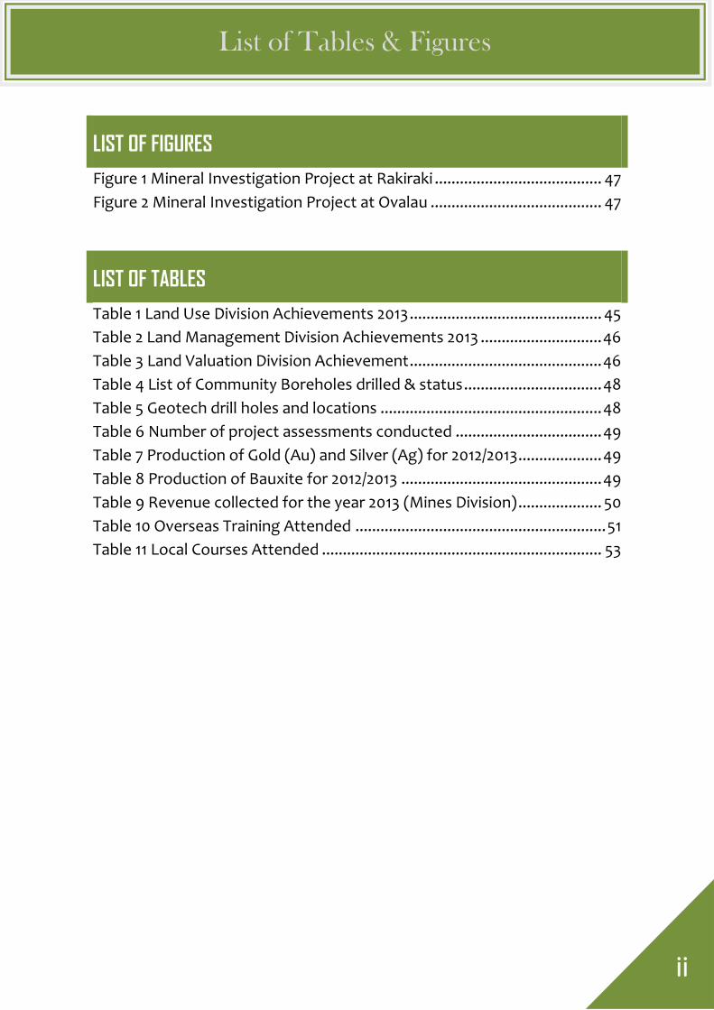
LIST OF FIGURES
Figure 1 Mineral Investigation Project at Rakiraki ........................................ 47
Figure 2 Mineral Investigation Project at Ovalau ......................................... 47
LIST OF TABLES
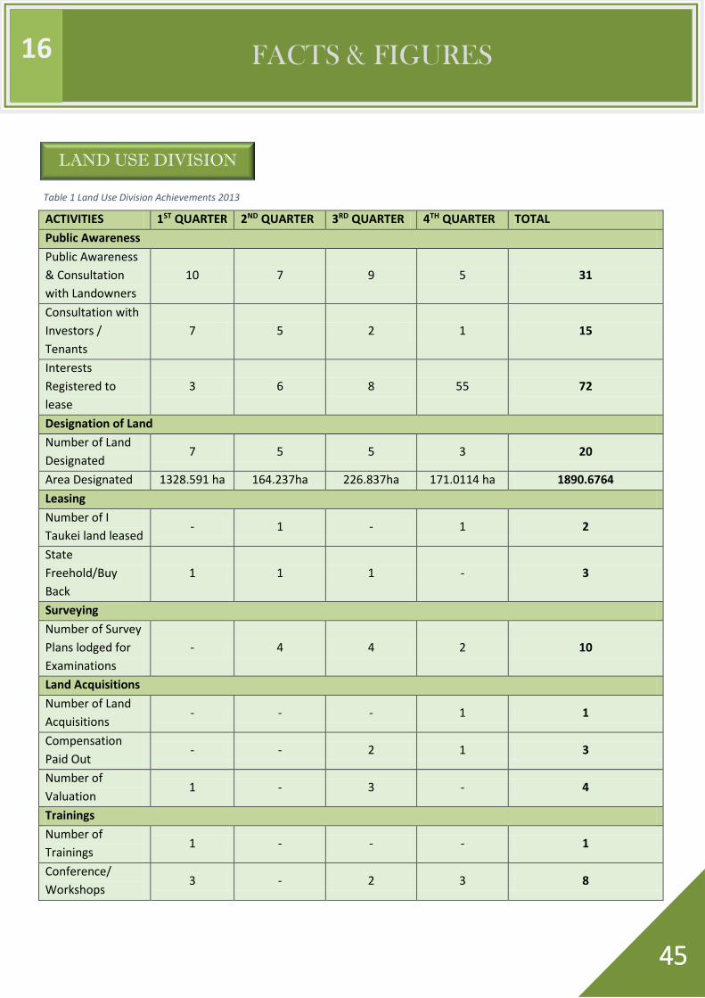
Table 1 Land Use Division Achievements 2013 .............................................. 45
Table 2 Land Management Division Achievements 2013 ............................. 46
Table 3 Land Valuation Division Achievement .............................................. 46
Table 4 List of Community Boreholes drilled & status ................................. 48
Table 5 Geotech drill holes and locations ..................................................... 48
Table 6 Number of project assessments conducted ................................... 49
Table 7 Production of Gold (Au) and Silver (Ag) for 2012/2013 .................... 49
Table 8 Production of Bauxite for 2012/2013 ................................................ 49
Table 9 Revenue collected for the year 2013 (Mines Division) .................... 50
Table 10 Overseas Training Attended ............................................................ 51
Table 11 Local Courses Attended ................................................................... 53
List of Tables & Figures
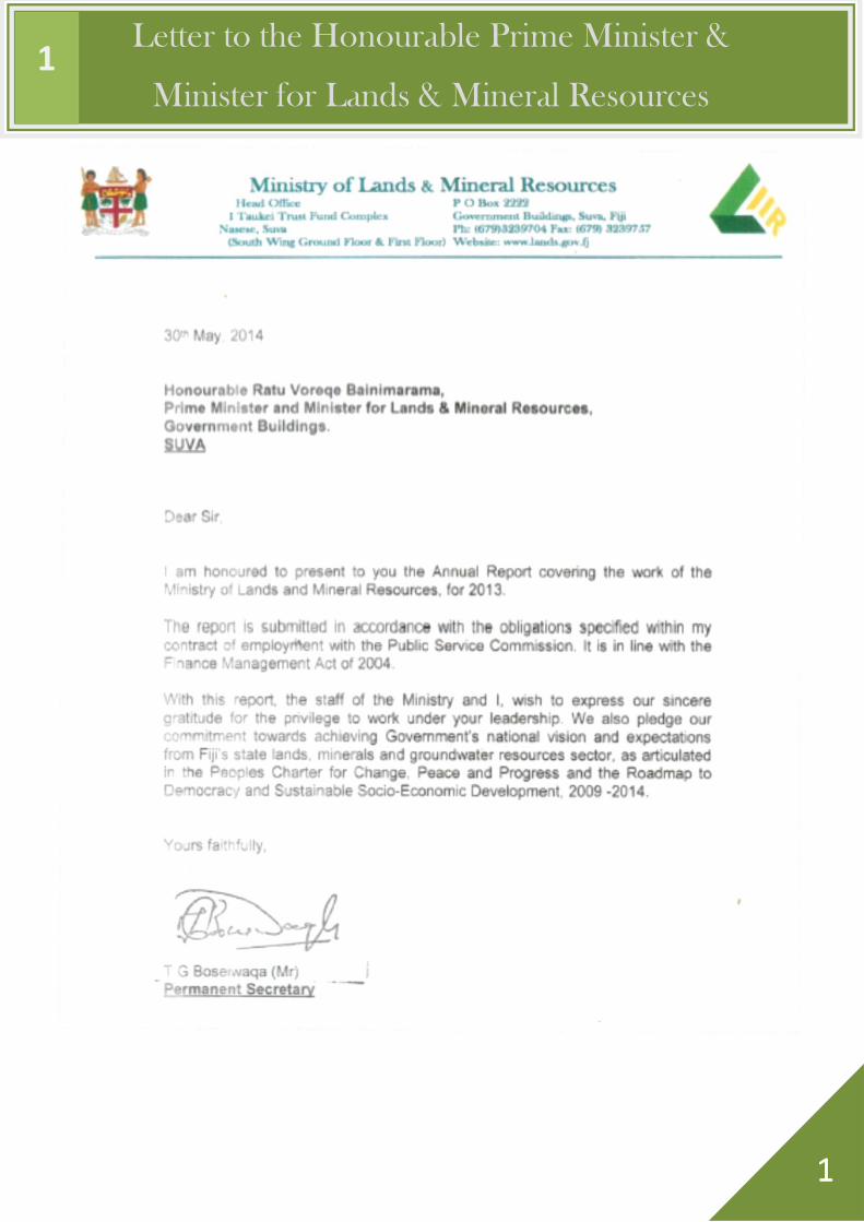
1
Letter to the Honourable Prime Minister &
Minister for Lands & Mineral Resources 1
2
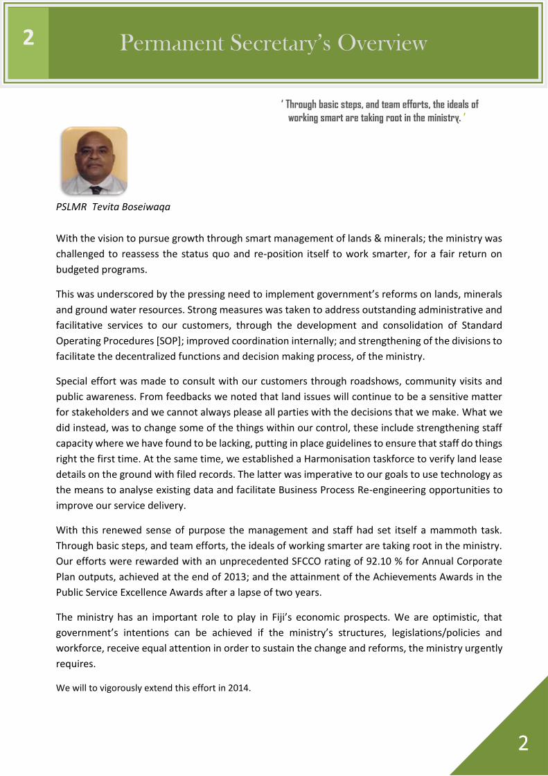
Permanent Secretary’s Overview 2
‘ Through basic steps, and team efforts, the ideals of
working smart are taking root in the ministry. ’
PSLMR Tevita Boseiwaqa
With the vision to pursue growth through smart management of lands & minerals; the ministry was
challenged to reassess the status quo and re-position itself to work smarter, for a fair return on
budgeted programs.
This was underscored by the pressing need to implement government’s reforms on lands, minerals
and ground water resources. Strong measures was taken to address outstanding administrative and
facilitative services to our customers, through the development and consolidation of Standard
Operating Procedures [SOP]; improved coordination internally; and strengthening of the divisions to
facilitate the decentralized functions and decision making process, of the ministry.
Special effort was made to consult with our customers through roadshows, community visits and
public awareness. From feedbacks we noted that land issues will continue to be a sensitive matter
for stakeholders and we cannot always please all parties with the decisions that we make. What we
did instead, was to change some of the things within our control, these include strengthening staff
capacity where we have found to be lacking, putting in place guidelines to ensure that staff do things
right the first time. At the same time, we established a Harmonisation taskforce to verify land lease
details on the ground with filed records. The latter was imperative to our goals to use technology as
the means to analyse existing data and facilitate Business Process Re-engineering opportunities to
improve our service delivery.
With this renewed sense of purpose the management and staff had set itself a mammoth task.
Through basic steps, and team efforts, the ideals of working smarter are taking root in the ministry.
Our efforts were rewarded with an unprecedented SFCCO rating of 92.10 % for Annual Corporate
Plan outputs, achieved at the end of 2013; and the attainment of the Achievements Awards in the
Public Service Excellence Awards after a lapse of two years.
The ministry has an important role to play in Fiji’s economic prospects. We are optimistic, that
government’s intentions can be achieved if the ministry’s structures, legislations/policies and
workforce, receive equal attention in order to sustain the change and reforms, the ministry urgently
requires.
We will to vigorously extend this effort in 2014.
3
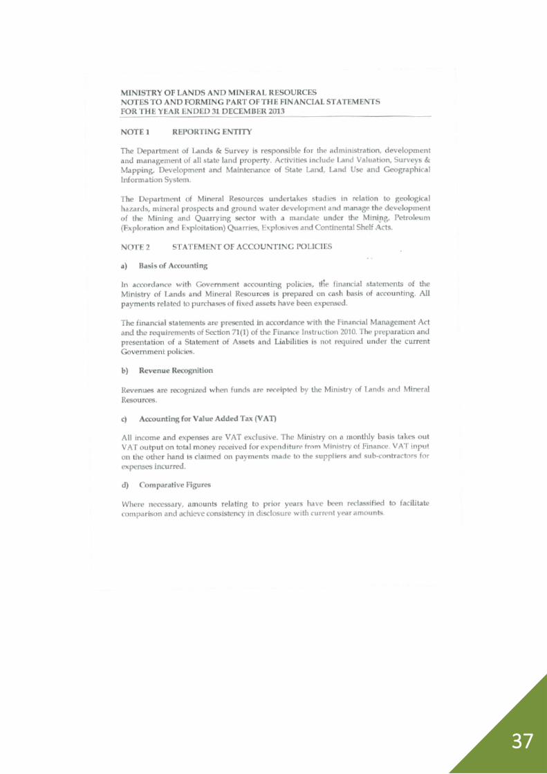
The Ministry of Lands & Mineral Resources is one of government’s key economic stakeholders in
terms of developing resource based sectors. In the past couple of years, this role has been
intensified as government taps into the nation’s rich resource base, for an economically vibrant
Fiji. In this capacity the ministry undertakes two critical programmes;
1. Department of Lands & Survey - is responsible for the administration, development and management of all State land activities. Activities under this programme include Land Surveying and Valuation, Development and Maintenance of State Land and Geographic Information Systems and the Land Use Unit, which coordinates the implementation of Government’s Land Reform initiatives to improve socio-economic growth, focusing on equitable returns to landowners and the security of tenure for the tenants. Functions and responsibilities of the department are further categorized under the following entities:
State Land Management Division
Land Use Unit
Land Survey Division
Geospatial Division
Land Valuation Division
Corporate Services Division
2. Department of Mineral Resources - oversees and facilitates development of the country’s mineral and groundwater resources. It undertakes studies in relation to geographical hazard assessment which includes earthquake and tsunami monitoring, mineral and groundwater development and manages the development of the mining and quarrying sector with a mandate under the Mining, Petroleum (Exploration and Exploitation), Quarries, Explosives and Continental shelf Acts. The department consists of four divisions which constitutes the overall mining and groundwater resources. These are namely the;
Geological Services Division
Geological Survey & Information Division
Mining Division
Agency Roles & Responsibilities 3
4
Our Vision, Mission & Values 4
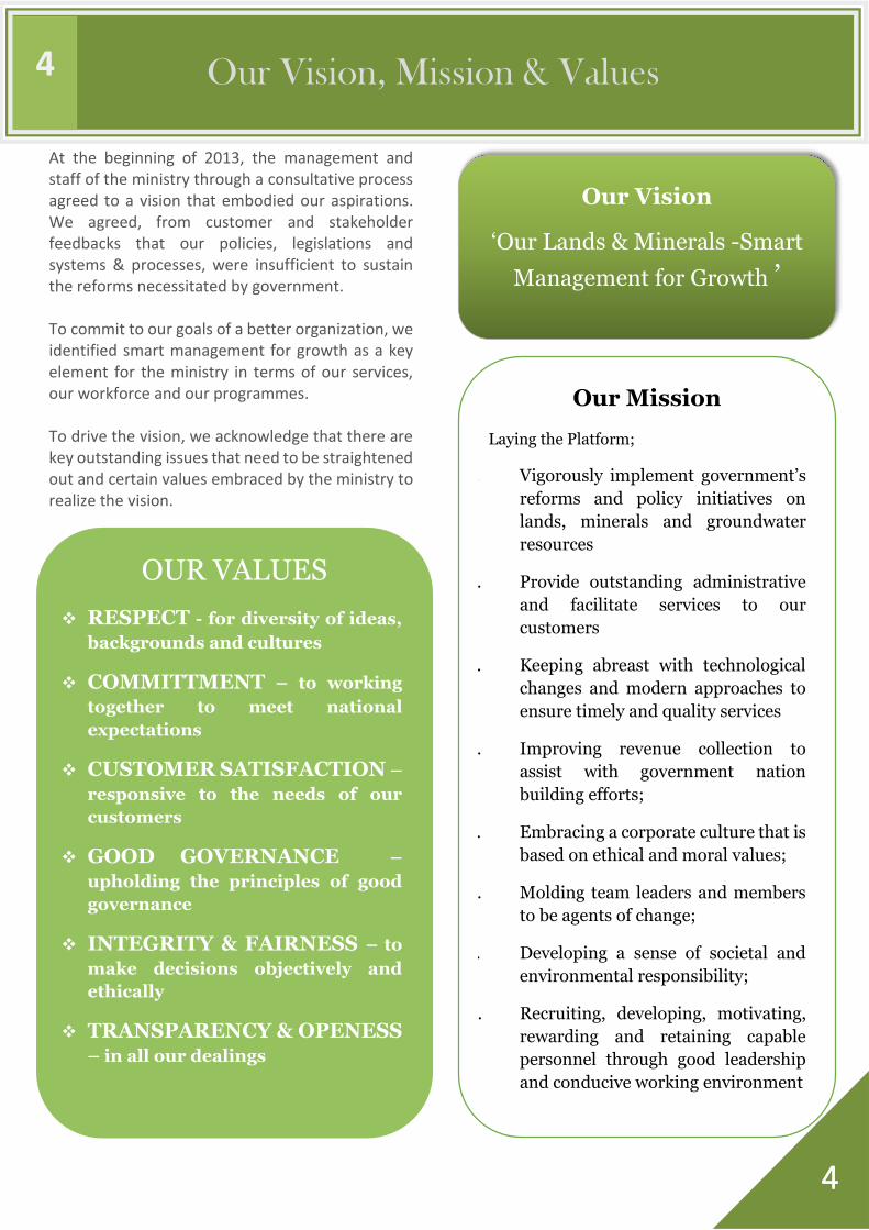
Our Vision
‘Our Lands & Minerals -Smart
Management for Growth ’
Our Mission
Laying the Platform;
1. Vigorously implement government’s
reforms and policy initiatives on
lands, minerals and groundwater
resources
2. Provide outstanding administrative
and facilitate services to our
customers
3. Keeping abreast with technological
changes and modern approaches to
ensure timely and quality services
4. Improving revenue collection to
assist with government nation
building efforts;
5. Embracing a corporate culture that is
based on ethical and moral values;
6. Molding team leaders and members
to be agents of change;
7. Developing a sense of societal and
environmental responsibility;
8. Recruiting, developing, motivating,
rewarding and retaining capable
personnel through good leadership
and conducive working environment
OUR VALUES
RESPECT - for diversity of ideas,
backgrounds and cultures
COMMITTMENT – to working
together to meet national
expectations
CUSTOMER SATISFACTION –
responsive to the needs of our
customers
GOOD GOVERNANCE –
upholding the principles of good
governance
INTEGRITY & FAIRNESS – to
make decisions objectively and
ethically
TRANSPARENCY & OPENESS – in all our dealings
At the beginning of 2013, the management and staff of the ministry through a consultative process agreed to a vision that embodied our aspirations. We agreed, from customer and stakeholder feedbacks that our policies, legislations and systems & processes, were insufficient to sustain the reforms necessitated by government. To commit to our goals of a better organization, we identified smart management for growth as a key element for the ministry in terms of our services, our workforce and our programmes. To drive the vision, we acknowledge that there are key outstanding issues that need to be straightened out and certain values embraced by the ministry to realize the vision.
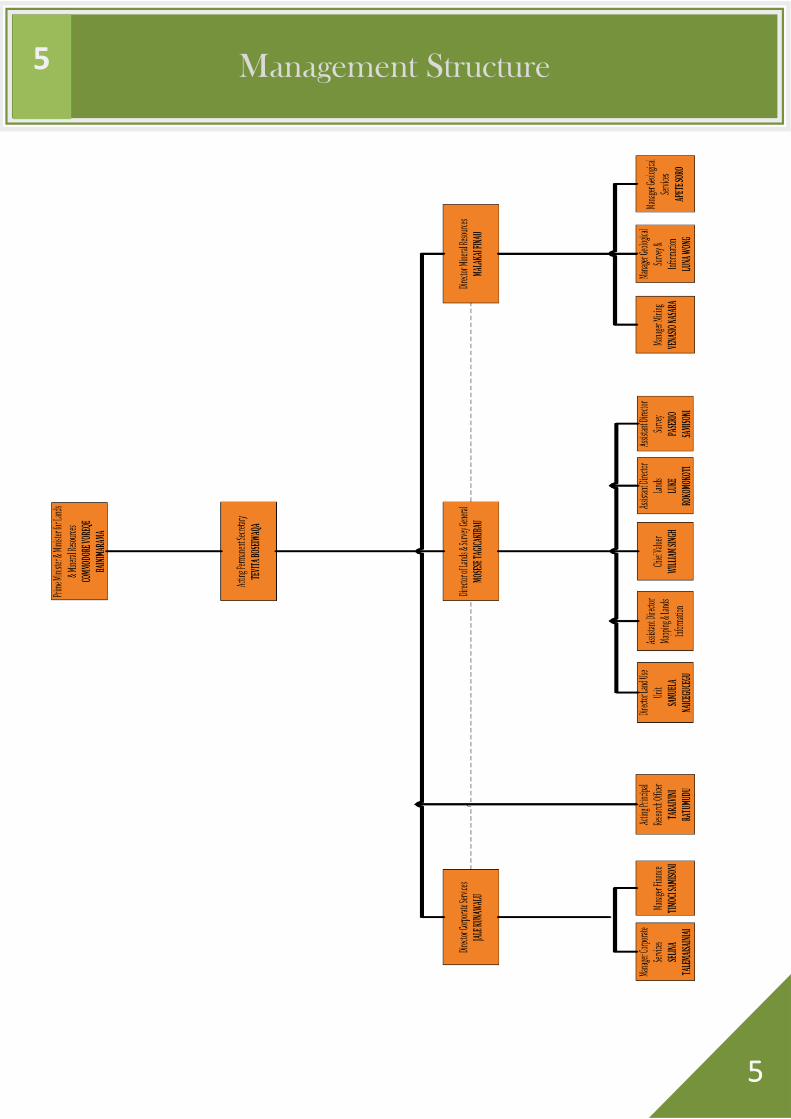
5
Management Structure 5
6
LAND ADMINISTRATION &
MANAGEMENT
Output 7: Client Complaints Investigations – Land
Management Services
Output 11: Land Management Services – Lease and
Valuation and State Land Management, Land Survey and
Development
6
Overview
The Lands Administration Division is responsible for one of the major products of the Ministry. In this capacity the division is often referred to as the heart of land operations because it deals with the issuance of state land leases and licenses.
It also facilitates the administration of State Land in Fiji which involve services such as the processing of consent to land dealings, processing of lease applications, preparation, stamping and registration of leases, licenses and other land related legal documents in compliance to the provisions of the State Lands Act, Land Transfer Act, Property Law Act, Land Sales Act, Land Acquisition Act, Agricultural Land Tenancy Act, State Land Policies and State Land Standard Operation Procedures.
The Division consists of four (4) units strategically positioned at each divisional office;
1. the Divisional Lands Office–Western,
2. Divisional Lands Office-Northern,
3. Divisional Lands Office-Central/Eastern and
4. Headquarters.
A total of 21 staff facilitates the operation of the entire Lands Division headed by the Assistant Director of Lands and assisted by the Principal Lands Officer who is coordinating the operations of the entire Lands unit of each Division from Headquarters.
Targeted outputs are derived from the stipulated Annual Business Plans for every sections; which is aligned to the Annual Corporate Plan (MLMRCP)
A/ Director Lands P. Prasad
A/Asst. Director Lands
W. Singh
Divisional Land Manager West I. Navunisaravi
A/ Divisional Land Manager Central
Eastern S. Kumar
A/Divisional Land Manager North
J. Vuniamatana & A. Dayal
A/Principal Lands Officer T. Ratumudu
Highlight
In line with ACP target 2013, the Division managed to surpass its annual target of 3500 by processing 4681 legal documents for the year ending 2013.
Developing of the draft SOP for Lands Administration
7
Challenges In the past, the division was largely neglected by the
management. Consequently, it was inundated with
complaints and criticism, related to turnaround time
for granting of consents to land dealings and general
issues on leasing and licensing.
Indeed concise concern/feedback was taken
constructively instigating internal upgrading by
management. This resulted in the strengthening of the
land management division and the appointment of
graduates with Land Management background. This
initiative has positively impacted the output of the
division as evident in the successful achievement of
annual corporate plan outputs.
Way Forward
Successful implementation of Lands Administration
Standard Operation Procedure (SOP) 2014 and
strategic approach assistance to the Division[s] in
ensuring consistency and timely delivery of services to
our clients.
All Lands officers have been guided to adhere to the
requirements of the SOP while performing their duties.
Therefore all operations are to be conducted in a
corporate culture as captured in the Public Service
Commission Service Excellence Awards Framework.
All Lands officers have been guided to adhere
to the requirements of the SOP while
performing their duties.
8
Mr. David Chang
Act. Surveyor General
Mr. Asakaia Tabua
Act. Principal Surveyor Control
Mr. Munil Dutt
Senior Surveyor Central Eastern
Mr. Vakawale Waqawai
Act Senior Surveyor Western
Mr. Asheesh Dayal
Senior Surveyor Northern
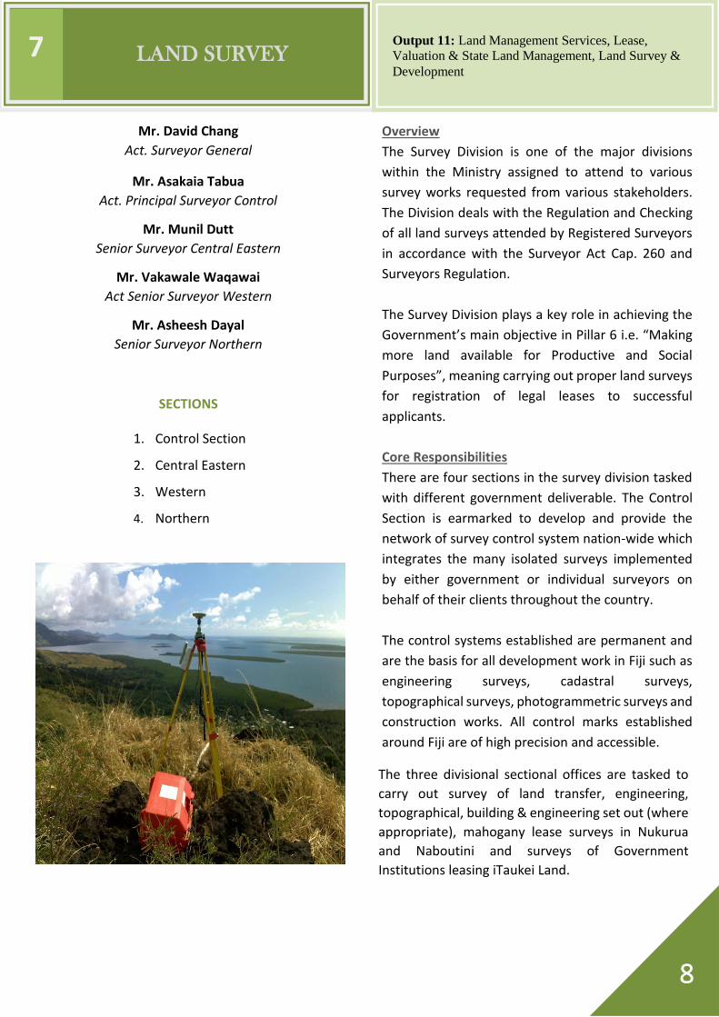
Overview
The Survey Division is one of the major divisions
within the Ministry assigned to attend to various
survey works requested from various stakeholders.
The Division deals with the Regulation and Checking
of all land surveys attended by Registered Surveyors
in accordance with the Surveyor Act Cap. 260 and
Surveyors Regulation.
The Survey Division plays a key role in achieving the
Government’s main objective in Pillar 6 i.e. “Making
more land available for Productive and Social
Purposes”, meaning carrying out proper land surveys
for registration of legal leases to successful
applicants.
Core Responsibilities
There are four sections in the survey division tasked
with different government deliverable. The Control
Section is earmarked to develop and provide the
network of survey control system nation-wide which
integrates the many isolated surveys implemented
by either government or individual surveyors on
behalf of their clients throughout the country.
The control systems established are permanent and
are the basis for all development work in Fiji such as
engineering surveys, cadastral surveys,
topographical surveys, photogrammetric surveys and
construction works. All control marks established
around Fiji are of high precision and accessible.
The three divisional sectional offices are tasked to
carry out survey of land transfer, engineering,
topographical, building & engineering set out (where
appropriate), mahogany lease surveys in Nukurua
and Naboutini and surveys of Government
Institutions leasing iTaukei Land.
SECTIONS
1. Control Section
2. Central Eastern
3. Western
4. Northern
LAND SURVEY Output 11: Land Management Services, Lease,
Valuation & State Land Management, Land Survey &
Development 7
9
Highlights The highlight for the survey division is the implementation of the following capital projects;
Development of State Land To develop vacant or underutilized state land for industrial subdivision or residential subdivision achieving Pillar 6 on peoples charter making more land available for productive and social purposes.
Maintenance of Existing Subdivision The purpose of this project is to upgrade and improve infrastructure, public utilities and amenities in existing subdivisions on state lands to enhance healthy living standard in urban area
Survey of Mahogany Plantations The project is to survey the un-survey mahogany lease on iTaukei land to determine accurate acreage of each lease lot for proper lease registration.
Survey of Namosi TLC Boundaries To demarcate and survey the various Mataqali TLC land boundaries within the tikina of Namosi and its environs to provide legal parcel descriptions for registration.
National Geodetic Infrastructure Geodetic Survey control framework and connect to the National framework system in areas where none in place and/or upgrade the ones that need upgrading to ensure that survey control marks are easily accessible to surveyors carrying out work in most parts of Fiji, particularly in areas where developments are focused.
Replacement of Survey Equipment The project is to replace obsolete survey instrument and accessories for efficiency and accuracy in actual survey works. The factor in having modern equipment’ is the changing technology, which enables surveyor to carry out tasks in a very limited time, thus saving the valuable man-hours both in the field and in the office.
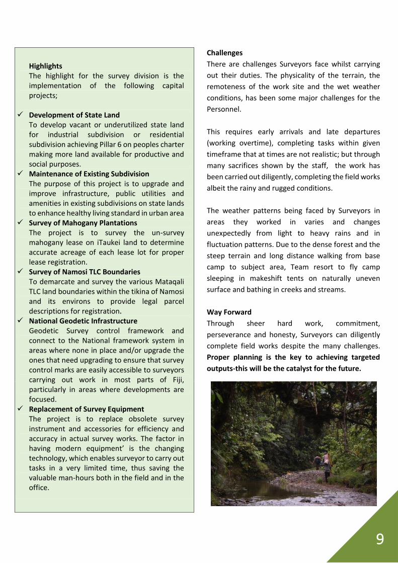
Challenges
There are challenges Surveyors face whilst carrying
out their duties. The physicality of the terrain, the
remoteness of the work site and the wet weather
conditions, has been some major challenges for the
Personnel.
This requires early arrivals and late departures
(working overtime), completing tasks within given
timeframe that at times are not realistic; but through
many sacrifices shown by the staff, the work has
been carried out diligently, completing the field works
albeit the rainy and rugged conditions.
The weather patterns being faced by Surveyors in
areas they worked in varies and changes
unexpectedly from light to heavy rains and in
fluctuation patterns. Due to the dense forest and the
steep terrain and long distance walking from base
camp to subject area, Team resort to fly camp
sleeping in makeshift tents on naturally uneven
surface and bathing in creeks and streams.
Way Forward
Through sheer hard work, commitment,
perseverance and honesty, Surveyors can diligently
complete field works despite the many challenges.
Proper planning is the key to achieving targeted
outputs-this will be the catalyst for the future.
10
Kaa’ke Teke
Acting Chief Valuer
Farzana Khan
Acting Principal Valuer-Acquisition and Special
Valuation
Meredani Tuitubou
Acting Senior Valuer-Statistics & Property
Research
Ateca Cagilevu
Acting Senior Valuer Rating
Janice Reuben
Senior Valuer Rental Estate
HIGHLIGHTS
The main highlight of the Valuation division includes
the following;
Staff Realignment
The Ministry in order to address land management
issues to be able to provide a more customer oriented
service, embarked on new goal through the re-
alignment of valuation staffs to achieve this.
This change concept was initially met with resistance
by the staffs but after a serial of meeting and
explanation by Management, this was finally
accepted.
Payment of Municipal Council Rate Arrears
The government is required to pays city/town rates to
Councils for its properties within municipal
boundaries and as at the beginning of the year a figure
of some $5million was outstanding as arrears.
The Valuation Division undertakes a joint verification
with all Councils and as a result a final figure of some
$3million paid to all Councils as final arrears.
OVERVIEW
The Valuation Division is the arm of the Department
that provides professional valuation expertise to and
on behalf of government. The Division is headed by
the Chief Valuer who is also the chief adviser to
government on all valuation related issues.
There are four main areas of valuation that the
Division provides service to government and these
are (i) Land acquisition, (ii) Rental and Estate
valuation, (iii) Rating valuation and (iv) Valuations for
iTaukei land used for government purposes.
Accordingly, the Division is divided into these four
sections and in addition, a separate section under
Statistical and Property Research collates and
analyze real property information to be used for
valuation purpose. This property information is also
provided to private Valuers as well as to the general
public at a nominal cost.
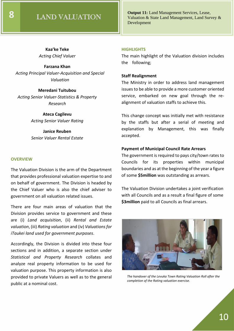
The handover of the Levuka Town Rating Valuation Roll after the completion of the Rating valuation exercise.
LAND VALUATION Output 11: Land Management Services, Lease,
Valuation & State Land Management, Land Survey &
Development 8
11
Vaivaka villagers from Namosi during a consultation meeting on
leasing issue for the proposed Health Centre
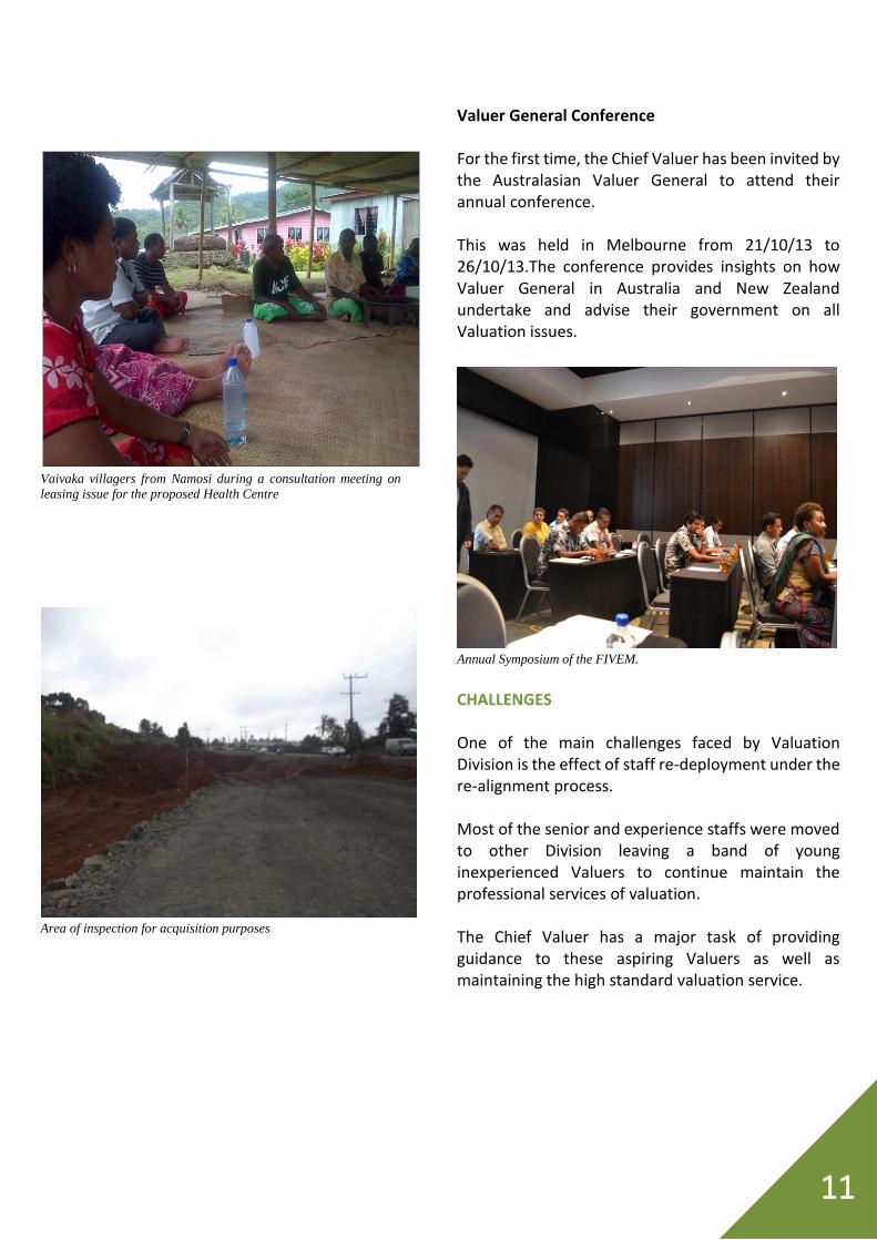
Valuer General Conference For the first time, the Chief Valuer has been invited by the Australasian Valuer General to attend their annual conference. This was held in Melbourne from 21/10/13 to 26/10/13.The conference provides insights on how Valuer General in Australia and New Zealand undertake and advise their government on all Valuation issues.
Annual Symposium of the FIVEM.
Area of inspection for acquisition purposes
CHALLENGES One of the main challenges faced by Valuation Division is the effect of staff re-deployment under the re-alignment process. Most of the senior and experience staffs were moved to other Division leaving a band of young inexperienced Valuers to continue maintain the professional services of valuation. The Chief Valuer has a major task of providing guidance to these aspiring Valuers as well as maintaining the high standard valuation service.
12
Director Land Use Unit Samuela Naicegucegu
A/Principal Valuer Irena Nayacalevu
A/Principal Surveyor Junior Ritesh Pratap
OVERVIEW
The Land Use Unit was established in July of 2010 as a direct result of the
promulgation of the Land Use Decree of July 2010.
The framework development was an endeavour to address the, ‘lack of
access to land for both productive and social purposes’ that was
highlighted in the Report on the State of the Nation and Economy (2008)
by the National Council for Building a Better Fiji (NCBBF) gathered through
a nationwide consultation process.
In this regard, the Land Use Unit aims to facilitate a, ‘mutually beneficial
system that encourages the leasing of land for all purposes, designs
incentives to ensure productive utilization of the land, and ensures
equitable returns for both tenants in the use of the land and landowners
in the leasing of their land’ (RDSSED, 2009)
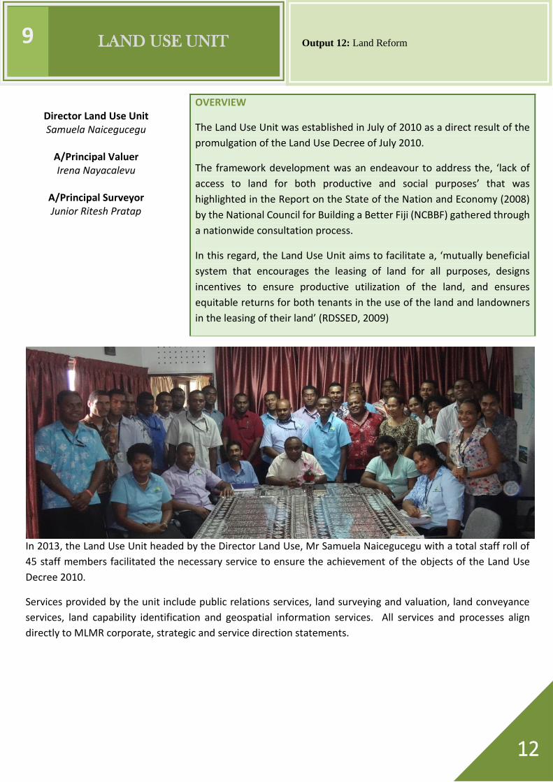
In 2013, the Land Use Unit headed by the Director Land Use, Mr Samuela Naicegucegu with a total staff roll of
45 staff members facilitated the necessary service to ensure the achievement of the objects of the Land Use
Decree 2010.
Services provided by the unit include public relations services, land surveying and valuation, land conveyance
services, land capability identification and geospatial information services. All services and processes align
directly to MLMR corporate, strategic and service direction statements.
LAND USE UNIT Output 12: Land Reform 9
13
Staff development throughout the year consisted
of both overseas and local trainings which centred
on Geospatial Information Systems, Disaster Risk
Management, Sustainable Development and
Good Governance Trainings and Workshops.
A total of 6 overseas trainings were attended by
staff of the unit whilst local trainings and
workshops included those coordinated in house,
by PSC and by NGOs. The Land Use Unit was
consistently represented at MLMR sports and
social activities of 2013.
Three years from inception LUU ventures on with
growing clarity in its bid to provide solutions that
would address the interests of both land owning
units and tenants in a holistic and equitable
manner to enable better utilisation of idle land.
Highlights
The issue of a lease for 687.97 hectares of prime cane land within the Seaqaqa sugar cane belt to Fiji Sugar Corporation. The Land owning unit, the members of Mataqali Devo of Natua, Macuata were paid out a premium of $220, 000 in February, 2013 as a condition of the issued lease;
The issue of a Residential lease to Ministry of Local Government for the relocation of 7 households at Wailekutu Settlement;
The establishment of the Land Use Unit at
Manager West office; and
The FIG PACIFIC SID SYMPOSIUM Novotel
Lami on 18 – 20th September and organized by FIG & Ministry of Lands and Mineral Resources.
‘…the Land Use Unit aims to facilitate a
‘mutually beneficial system that
encourages the leasing of land for all
purposes, and designs incentives to
ensure productive utilization of the
land…’
14
Akata Takala
Act Director
Malakai Vakautawale
Act Principal Geospatial Officer (FGIS)
Meizyanne Hicks
Act Principal Geospatial Officer (Mapping)
Jone Cavu
Act Principal Plan Examiner
OVERVIEW
In the past maps were used to locate people and
objects. Today this has changed into a complex digital
environment where geospatial information supports
a wide range of government, business and
community activities and is vital to decision making.
The Geospatial Information Division in its capacity as
the custodians and providers of base geospatial
information has in 2013 supported interested
stakeholders to achieve their targets.
While this support was being provided, the Division
continued with its core functions that are shared
amongst its 6 sections which performed tasks such as:
Providing efficient mapping and aerial
photography services
Coordinate and implement land computerize
system and the ultimate establishment of a
national Spatial Data and land tenure system
Development and coordinate cadastral and
land tenure system
Providing efficient information and statistics
on status and rights to land
Support for the Land Reform initiative
SECTIONS
1. Fiji Geospatial Information Systems
2. Aerial Survey
3. Cartography
4. Draughting Office
5. Statutory Office
6. Plan Examination
Major Projects Together with carrying out its core functions, the Division has been tasked with 3 Capital Projects and there are
GEOSPATIAL INFORMATION
MANAGEMENT Output 9: Maintenance of Land and Geographic
Information System 10
15
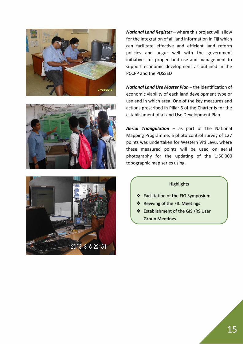
National Land Register – where this project will allow
for the integration of all land information in Fiji which
can facilitate effective and efficient land reform
policies and augur well with the government
initiatives for proper land use and management to
support economic development as outlined in the
PCCPP and the PDSSED
National Land Use Master Plan – the identification of
economic viability of each land development type or
use and in which area. One of the key measures and
actions prescribed in Pillar 6 of the Charter is for the
establishment of a Land Use Development Plan.
Aerial Triangulation – as part of the National
Mapping Programme, a photo control survey of 127
points was undertaken for Western Viti Levu, where
these measured points will be used on aerial
photography for the updating of the 1:50,000
topographic map series using.
Highlights
Facilitation of the FIG Symposium
Reviving of the FIC Meetings
Establishment of the GIS /RS User
Group Meetings
16
Isireli Nagata Asst Director
Raijieli Baleiwai
Principal Scientific Officer (Environment)
Raymond Mohammed Act Principal Scientific Officer
(Mines Engineer)
Nilesh Karan Act Principal Technical Officer
(Tenement)
OVERVIEW
The Mining Division is one of the major Divisions within the Ministry that generates revenue for the Government. The Mining Division is responsible for using best practice, stronger customer focus to promote, facilitate and maintain a competitive minerals sector for Fiji that is beneficial to all stakeholders through:
I. Ensuring effective and efficient development of Fiji’s mineral sector through regulatory framework that exists in the Mining Act, the Explosives Act, the Quarries Act and the Environmental Management Act, and
II. Responsible to formulate, review and offer advice on policies; administer mining tenement; environmental monitoring and protection, social impact assessment liaison.
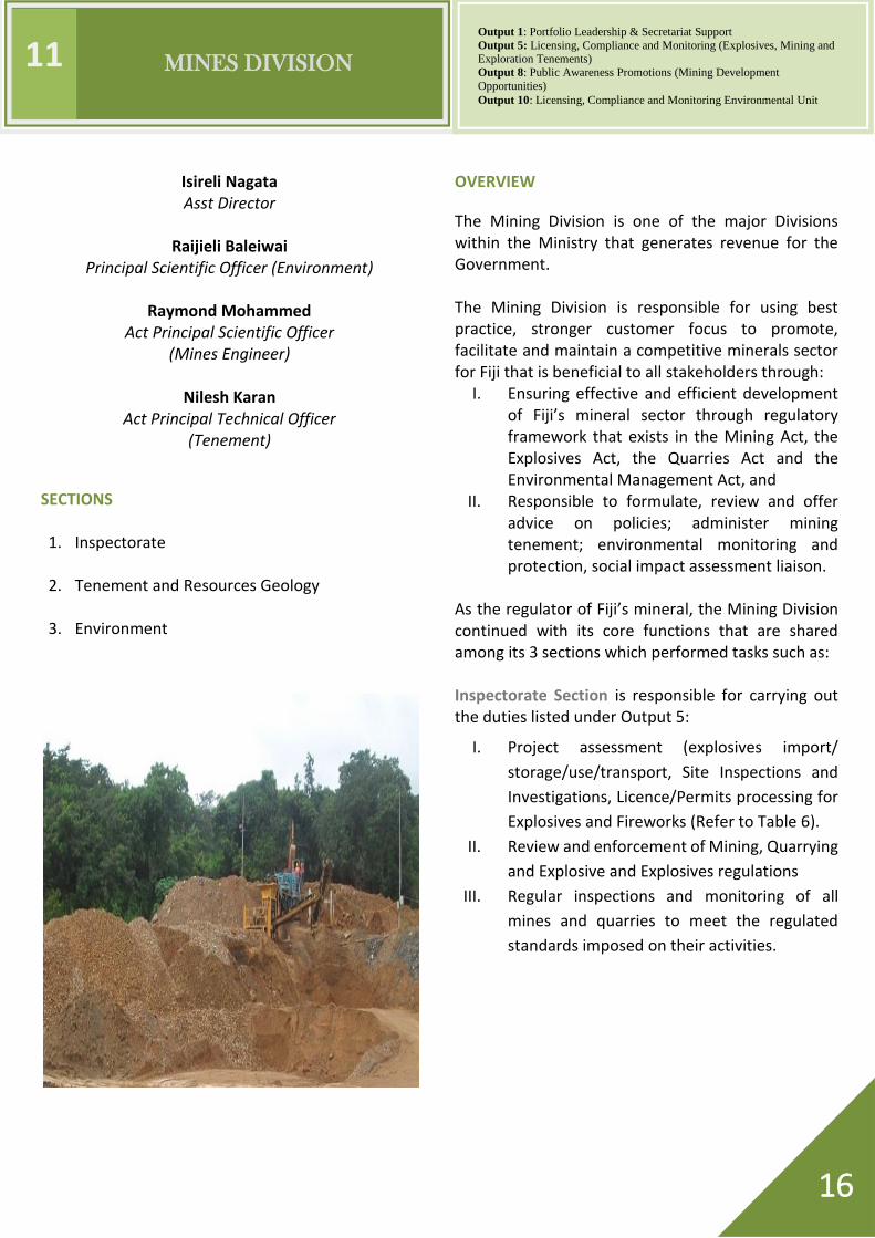
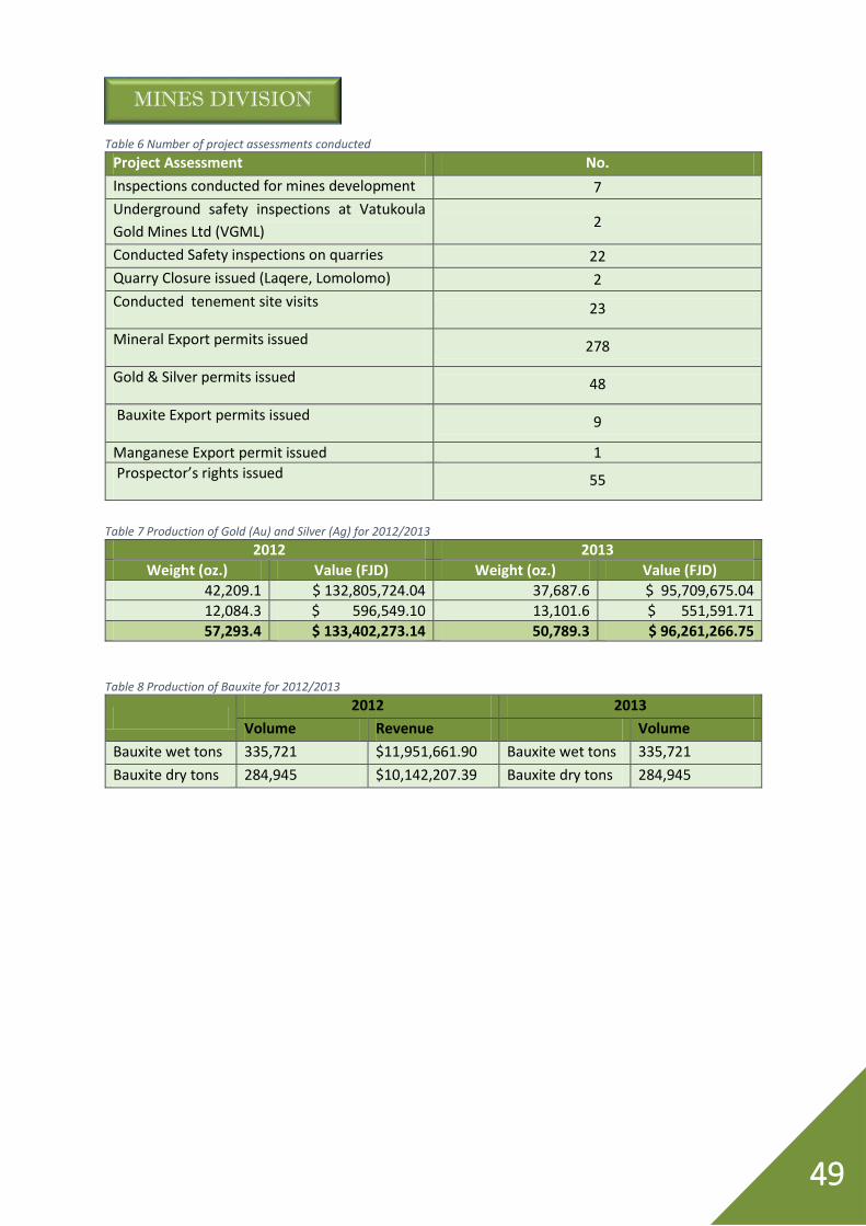
As the regulator of Fiji’s mineral, the Mining Division continued with its core functions that are shared among its 3 sections which performed tasks such as: Inspectorate Section is responsible for carrying out the duties listed under Output 5:
I. Project assessment (explosives import/
storage/use/transport, Site Inspections and
Investigations, Licence/Permits processing for
Explosives and Fireworks (Refer to Table 6).
II. Review and enforcement of Mining, Quarrying
and Explosive and Explosives regulations
III. Regular inspections and monitoring of all
mines and quarries to meet the regulated
standards imposed on their activities.
SECTIONS 1. Inspectorate
2. Tenement and Resources Geology
3. Environment
MINES DIVISION
Output 1: Portfolio Leadership & Secretariat Support
Output 5: Licensing, Compliance and Monitoring (Explosives, Mining and Exploration Tenements)
Output 8: Public Awareness Promotions (Mining Development
Opportunities)
Output 10: Licensing, Compliance and Monitoring Environmental Unit
11
17
This is achieved by developing clear approval and
assessment process for exploration, mining and
quarrying prospects. Key prospects and data are
updated, application processes are stream lined,
and administering and managing of exploration,
petroleum& exploration licences.
Exploration companies spent a total of
$47,052,956.88 from 2012 to 2013 while gold
and silver production decreased (Refer to Table
7). The decrease in the production was due to a
change in mining methods introduced by the
General Manager of Vatukoula Gold Mines
whereby underground ore production was
generated from slope mining.
Production also decreased because of a lack of
tailing storage facility and the delay in the
proposed Tailing Storage facility due to land
issues.
Bauxite mined for export increased in 2013 when
compared to 2012 (Refer to Table 8).
Nine stakeholders meetings were held regarding
the Namosi Joint Venture on exploration and
mining was held. In addition, twenty four
meetings were held with stakeholders on the
other advanced prospects.
The Unit also conducted eighty three community
awareness and promotions programme to
encourage them to supportive towards mining
and also for their information.
Environmental Section is responsible for carrying out
the duties listed under Output 10:
I. To manage the environmental and community
policy and regulatory processes regarding Fiji’s
mineral industry
II. To monitor and enforce regulations and
statutes that manages explorations and
development in the industry and oversee that
it is within a sustainable framework.
III. To regularly liaise with stakeholders including
landowners to inform interested parties of
environmental issues in any development.
IV. To offer advice to any interested party when
required
This is achieved by assessing Environmental
Impact Assessments for proposed developments
in the industry; conducting regular environmental
monitoring of all existing mine sites, quarry sites
and other developments; assisting other
departments in the enforcement of the
Environmental Management Act 2005 in aspects
of environmental issues if required; and
conducting awareness program around areas of
development and to the public when required.
The Unit conducted thirty nine inspections to
monitor mines and quarries for total compliance
with the environmental Act. This is apart from the
weekly monitoring on the Namosi Copper
Prospect during exploration and rehabilitation site
work.
Highlights
The review of the Mining Act – a critical government output; was our major highlight this year.
The Eleventh (11th) draft of the Mineral Exploration and Exploitation Decree (MEED) is with the Solicitors
General’s office. The Mineral Development Technical Committee was revived to review the MEED during
the year. UNDP also provided assistance in the review of the MEED through the American Bar Association,
who had provided their services on a pro bono basis based on a Memorandum of Understanding.
18
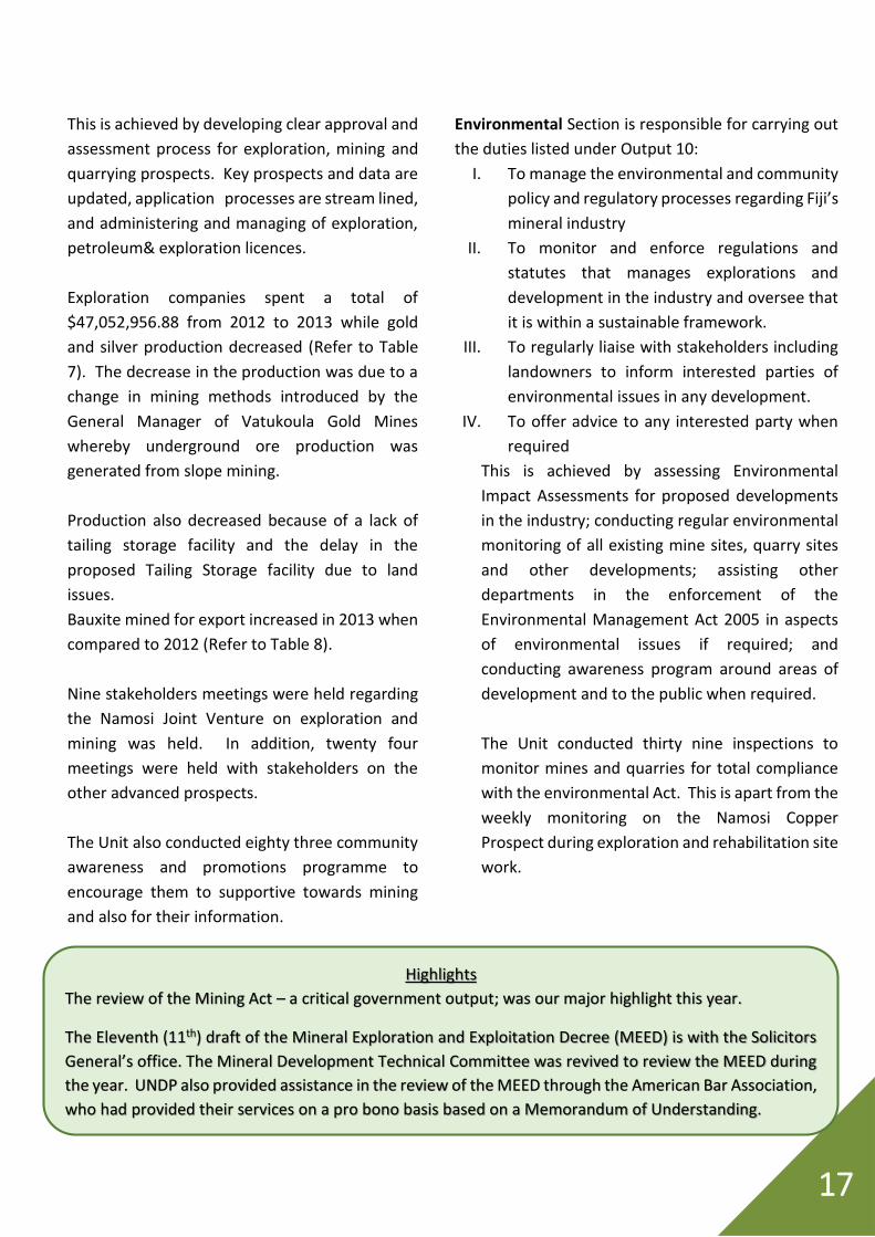
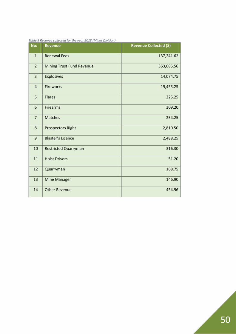
Revenue The total revenue collected from the Mines Division was $531,082.74 (Refer to Table 9). Outlook for 2014 Amex is expected to start mining of iron sand from
the Ba Delta in Late 2014. The Ground Breaking
ceremony for the construction of storage facility will
be held in early 2014 at the identified site at Lautoka
Wharf.
‘…the main highlight of the Division was
the review of the Mining Act – a critical
government output…’
19
Apete Soro
Assistant Director
Jonati Railala Principal Technical Officer
Illaitia Dakonivalu
Act Principal Scientific Officer
OVERVIEW
The Geological Services Division provides technical
services and geological hazard information to the
public and private sector. These include, Seismology
& Geo-hazards (monitoring of earthquakes, tsunamis.
The Division is also tasked with the responsibility of
developing groundwater resources in Fiji
(groundwater assessment & development), Drilling
for groundwater and geotechnical purposes and
Chemical Analysis (water, mine and quarry effluent,
mineral samples).
The Hydrogeological Section is responsible for the Policy paper on National Water Resources and Sanitation as well as the Groundwater Resources management and Exploitation Policy paper as listed under Out 1 as well as developing groundwater resources around Fiji as listed in Output 3. Amendments, in accordance with the 2013 Constitutions, were being incorporated in the National Water Resources and Sanitation Policy paper to be submitted to Cabinet for endorsement. The Groundwater Resources Management and Exploitation Policy has undergone three rounds of stakeholders consultation and was also being amended to see that it also incorporated the necessary provision of the 2013 Constitution.
The Division has been tasked with two major
capital projects :
I. Groundwater assessment and development for Small Islands,
II. Groundwater assessment and development for Small Islands
The Division over achieved its target of 24 assessment
for Groundwater sources investigations with 47
assessment being carried out. It should be noted that
development for groundwater is a request based
SECTIONS 1. Hydrogeological Section
2. Drilling Section
3. Seismology Section
4. Laboratory Section
GEOLOGICAL SERVICES
DIVISION
Output 1: Portfolio Leadership & Secretariat Support Output 3: Consulting Services< Groundwater Borehole &
Development
Output 4: Licensing, Compliance & Earthquake Monitoring
Output 13: Poverty Reduction (Alleviation)
12
20
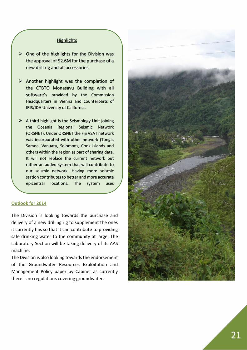
service and only favorable hydro geological
outcomes will lead to borehole drilling.
Two boreholes were drilled at Nananu for
commercial purposes with one borehole being
recommended fit for commercial use as it meets
WHO Standards for drinking water quality whilst the
other may require treatment to comply with such
quality standard.
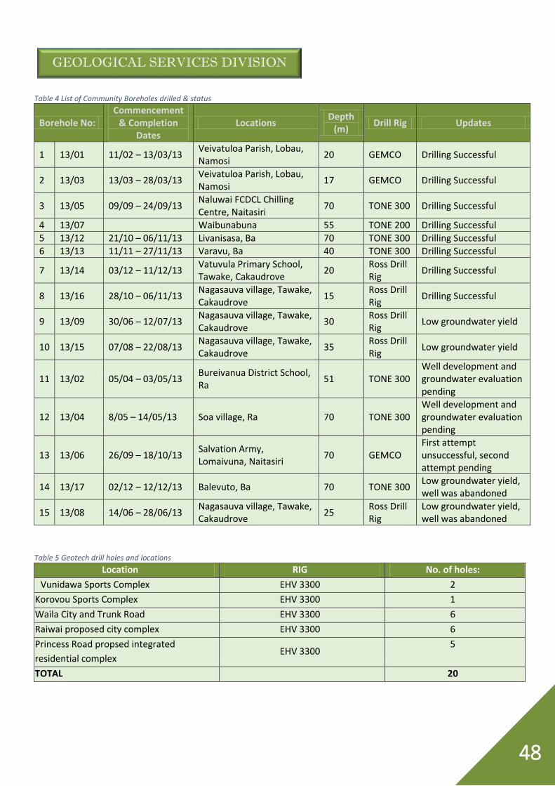
The Hydrogeological Section and the Drilling Section
did not achieve its target of drilling twenty boreholes
for the community. Only fifteen boreholes were
drilled and developed due to constant drilling
machine breakdown, wear and tear, unavailability of
spare parts locally as well as substandard repair and
maintenance in the past. Ten of the wells were drilled
successfully, with two of them with low groundwater
yield but is used by the community, two of the
boreholes are awaiting evaluation before community
use, two wells were abandoned due to low
groundwater yield and one site, a second well was
being attempted (Refer to Table 4).
The Hydrogeological Section was also able to conduct
thirteen well developments at various locations
where primary focus was on borehole
cleaning/flushing and quality and quantity test.
The Drilling Section, in addition to drilling for
groundwater also contributed to Output 4 through
the Geotechnical drilling work. This is demand
driven. At the end of the year the Geotech drilling
team completed 20 geotech test holes (Refer to
Table 5).
The Seismology Section contributed to Output 4. The
Section continued with the routine monitoring of
seismic activities and tsunami warnings where.
detection of events in Fiji as well as in the region were
analyzed to confirm potential risk it may pose. A total
of 951 local events and 2193 regional events were
detected and 144 Media Releases issued.
The Section had achieved its target of 88 centers for
earthquake & tsunami awareness consultations
focusing on coastal communities
(schools/villages/settlements). Coastal areas covered
were along northern coast of Ovalau, Moturiki and
also the southern and northern coast of Tailevu.
Other locations covered were DAV Girls College,
Dreketi Village, Ministry of Finance, Rotuma Island,
Yavusania and Naikeleyaga Village.
The CTBTO Monasavu civil works has been completed
and equipment configuration is still on-going with
continued visits from the Commission Headquarters
in Vienna and counterparts of IRIS/IDA University of
California.
The Laboratory Section has been flooded with
requests for water sample analysis of geochemical
and some microbiological analysis and had far
exceeded their yearly target of 320 with 353 analyses
completed.
The Laboratory did not take delivery of the AAS
Machine after the Government Tender Board
approved the tender but due to new criteria set by
the Fiji Procurement Office waiver of such request
was not approved by the Tender Board.
The Geological Services Division also contributed to
Out 13 by drilling fifteen boreholes to improve access
to sustainable clean drinking water for the
community. The provisions of boreholes have
rippling effects towards combating poverty in local
communities.
21
Outlook for 2014 The Division is looking towards the purchase and
delivery of a new drilling rig to supplement the ones
it currently has so that it can contribute to providing
safe drinking water to the community at large. The
Laboratory Section will be taking delivery of its AAS
machine.
The Division is also looking towards the endorsement
of the Groundwater Resources Exploitation and
Management Policy paper by Cabinet as currently
there is no regulations covering groundwater.
Highlights
One of the highlights for the Division was
the approval of $2.6M for the purchase of a
new drill rig and all accessories.
Another highlight was the completion of
the CTBTO Monasavu Building with all
software’s provided by the Commission
Headquarters in Vienna and counterparts of
IRIS/IDA University of California.
A third highlight is the Seismology Unit joining
the Oceania Regional Seismic Network
(ORSNET). Under ORSNET the Fiji VSAT network
was incorporated with other network (Tonga,
Samoa, Vanuatu, Solomons, Cook Islands and
others within the region as part of sharing data.
It will not replace the current network but
rather an added system that will contribute to
our seismic network. Having more seismic
station contributes to better and more accurate
epicentral locations. The system uses
SEISCOMP3 tool/software for locating seismic
22
Wong Hen Loon
Asst Director
Semi Bolalailai Act Principal Scientific Officer
Agnes Peter-Hansen
Senior Scientific Officer
Rigieta Ravuiwasa Act Senior Scientific Officer
OVERVIEW The role of the Survey Division is to provide geoscience information to support and regulate development of mineral (metalliferous and industrial), hydrocarbon and geothermal resources within Fiji and its EEZ for the benefit of Fiji and to provide information on geohazards. This is done by selection of priority areas in Fiji for geoscience mapping and surveys, assessment of potential for mining, petroleum production, geohazards and quarrying areas in Fiji, providing geoscience information services, industry consultation and support for geotechnical surveys. The Division continued with its core functions that were shared among its three sections which performed tasks such as:
i. Carrying out geological mapping surveys ii. Conducting oceanographic processes study to
mitigate for coastal erosion iii. Providing geosciences information to the
industry and stakeholders, and iv. Carrying out of Geo-technical assessments on
foreshore developments, landslide assessments and core logging for drill holes for development purposes.
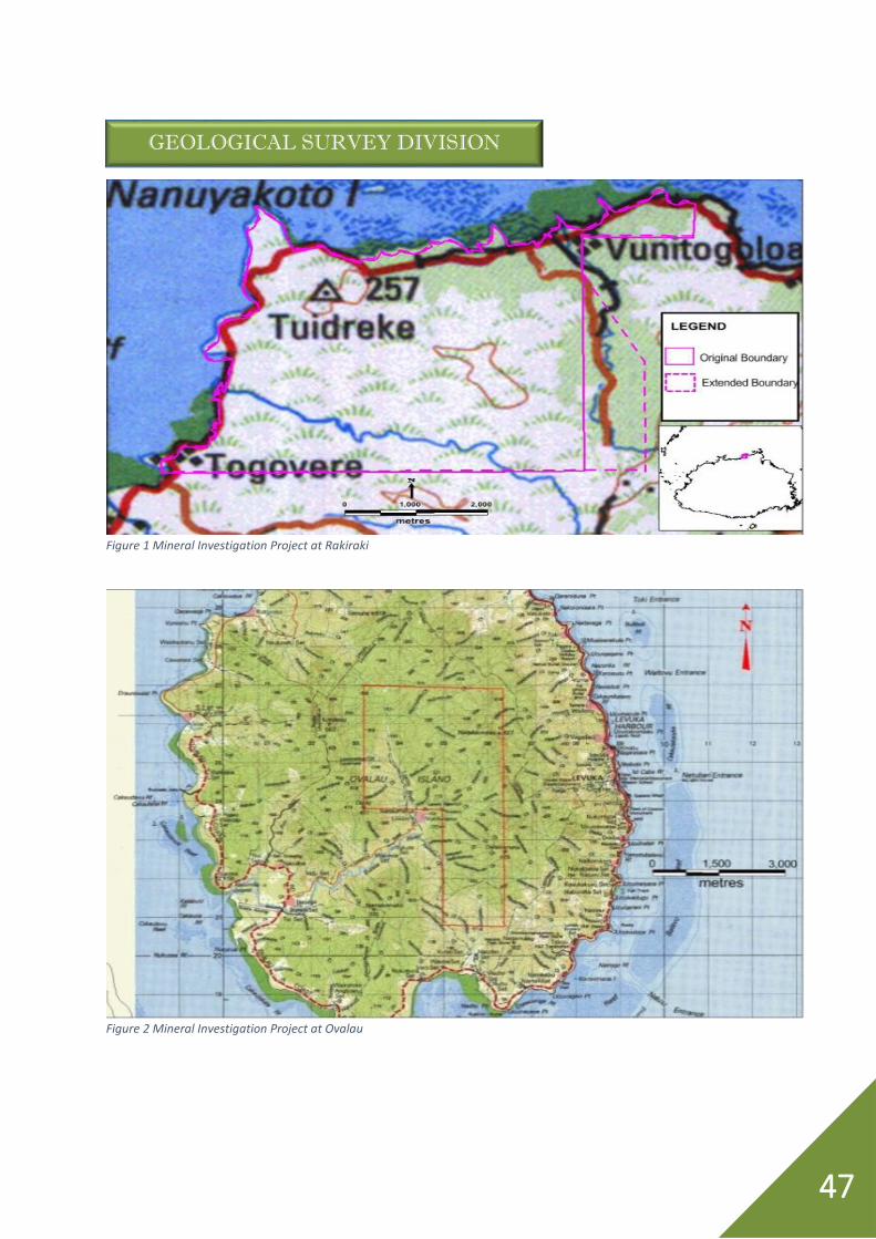
Major Projects Together with carrying out its core functions, the Division has been tasked with 1 Capital Projects and this is the Mineral Investigation Programme which started in 2008. The Geological Survey division’s major work
undertaken for the year 2013 included the Viti Levu
Mineral Investigation project in the Rakiraki Area
(Vunitogoloa to Togovere) (Figure 1) and on Ovalau
(Lovoni) (Figure 2). Six final Mineral Investigation
Reports was completed during the year. These
included the Saqani Report which was conducted in
the last quarter of 2012 and incorporates result of
samples collected using the handheld XRF Analyser.
SECTIONS 5. Geological Mapping
6. Engineering Geology
7. Coastal Geology
GEOLOGICAL SURVEY &
INFORMATION DIVISION
Output 2: Research Publications – Geological Surveys & Database
Output 4: Licensing, Compliance & Earthquake Monitoring
13
23
Samples from the Saqani, Rakiraki Area and Lovoni in Ovalau showed anomalous values for silver which would need to be confirmed by analysis abroad. The Mapping Section is responsible for Output 2 and the implementation of the Capital Project. Fieldwork was carried out on the two (2) targeted areas in Viti Levu and Ovalau. Geochemical mapping was also undertaken to find out anomalies in the area based on previous explorations works. Field work maps that were digitized include:
I. Sample location maps (rock, sediment & ridge samples)
i.Traverse maps ii.Geology & structural maps
iii.Alteration and mineralization map
As part of carrying out a Mineral Investigation Program on Lovoni, Ovalau, a seismic survey was conducted. Seven lines of 500 m in length was shot using the Shallow Seismic Refraction equipment at two areas where mineralisation was observed.
The mapping Section also conducted a Geological
mapping reconnaissance survey in the last quarter of
the year for Natural Waters of Viti Limited as part of
their extension program to determine the extent of
the aquifer which will contribute in establishing a
buffer zone for current and future water extraction
site.
MARINE SCIENTIFIC RESEARCH
Two Marine Scientific Cruises were carried out in Fiji’s national waters and the Division had two staff onboard as observers. The first was collecting bathymetric data for laying of cable from Suva to Port Vila. The second was a Marine Scientific Cruise conducted by KIOST for mapping of Deep-Sea Minerals in their offshore tenement.
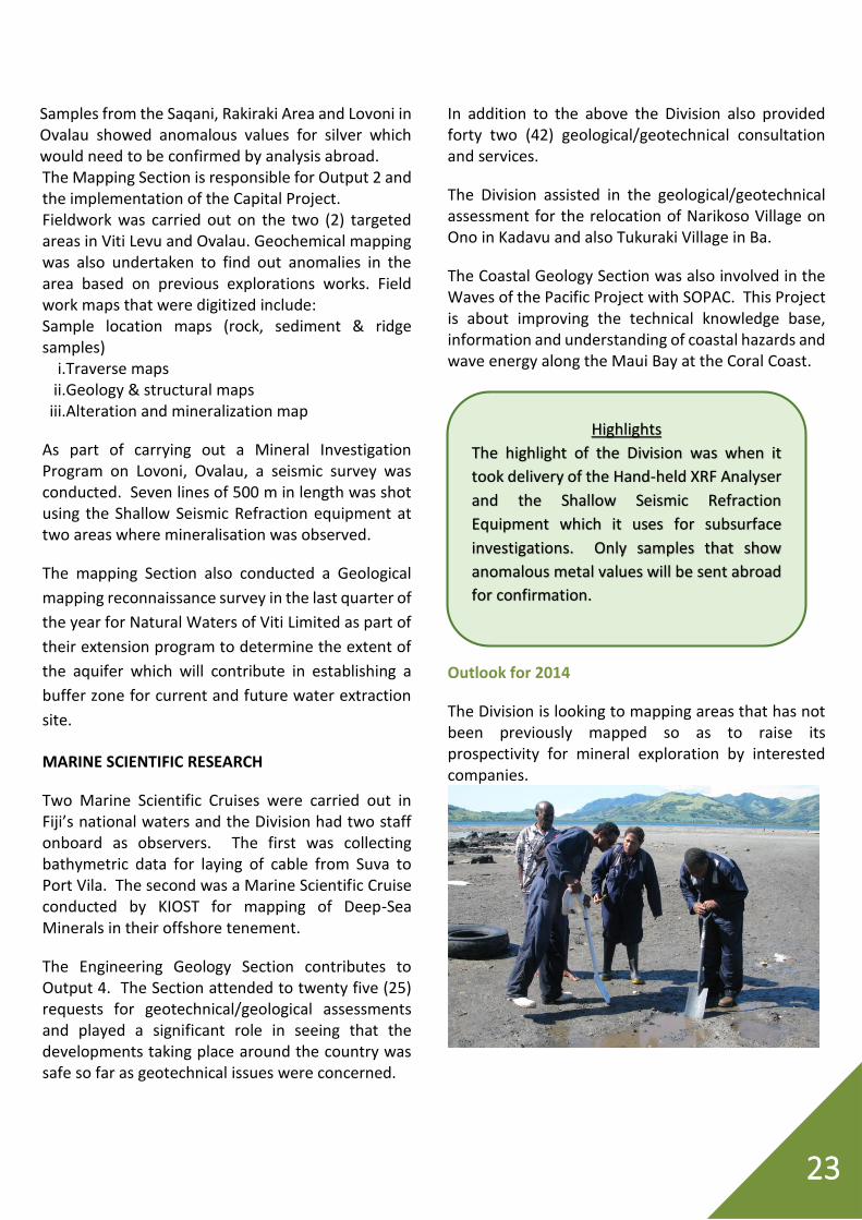
The Engineering Geology Section contributes to Output 4. The Section attended to twenty five (25) requests for geotechnical/geological assessments and played a significant role in seeing that the developments taking place around the country was safe so far as geotechnical issues were concerned.
In addition to the above the Division also provided forty two (42) geological/geotechnical consultation and services.
The Division assisted in the geological/geotechnical assessment for the relocation of Narikoso Village on Ono in Kadavu and also Tukuraki Village in Ba.
The Coastal Geology Section was also involved in the Waves of the Pacific Project with SOPAC. This Project is about improving the technical knowledge base, information and understanding of coastal hazards and wave energy along the Maui Bay at the Coral Coast.
Outlook for 2014
The Division is looking to mapping areas that has not been previously mapped so as to raise its prospectivity for mineral exploration by interested companies.
Highlights
The highlight of the Division was when it
took delivery of the Hand-held XRF Analyser
and the Shallow Seismic Refraction
Equipment which it uses for subsurface
investigations. Only samples that show
anomalous metal values will be sent abroad
for confirmation.
24
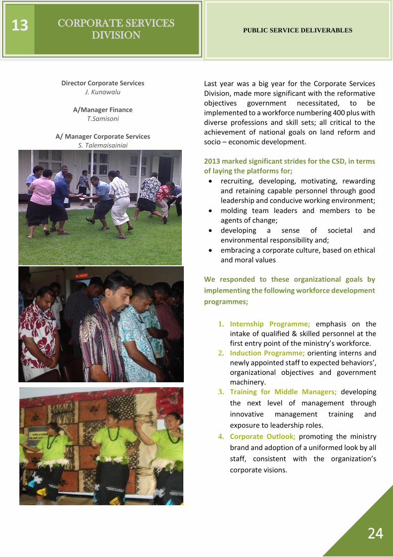
Director Corporate Services J. Kunawalu
A/Manager Finance
T.Samisoni
A/ Manager Corporate Services S. Talemaisainiai
Last year was a big year for the Corporate Services Division, made more significant with the reformative objectives government necessitated, to be implemented to a workforce numbering 400 plus with diverse professions and skill sets; all critical to the achievement of national goals on land reform and socio – economic development. 2013 marked significant strides for the CSD, in terms of laying the platforms for;
recruiting, developing, motivating, rewarding and retaining capable personnel through good leadership and conducive working environment;
molding team leaders and members to be agents of change;
developing a sense of societal and environmental responsibility and;
embracing a corporate culture, based on ethical and moral values
We responded to these organizational goals by
implementing the following workforce development
programmes;
1. Internship Programme; emphasis on the intake of qualified & skilled personnel at the first entry point of the ministry’s workforce.
2. Induction Programme; orienting interns and newly appointed staff to expected behaviors’, organizational objectives and government machinery.
3. Training for Middle Managers; developing
the next level of management through
innovative management training and
exposure to leadership roles.
4. Corporate Outlook; promoting the ministry
brand and adoption of a uniformed look by all
staff, consistent with the organization’s
corporate visions.
CORPORATE SERVICES
DIVISION PUBLIC SERVICE DELIVERABLES 13
25
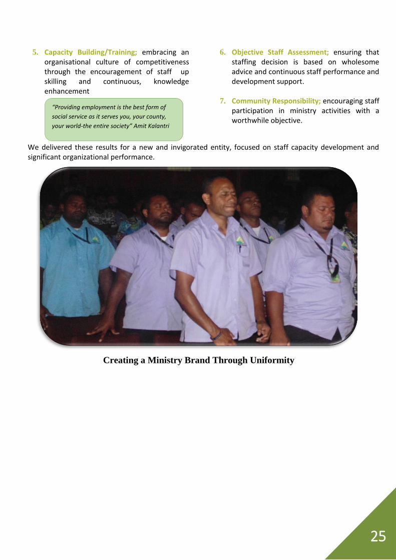
5. Capacity Building/Training; embracing an organisational culture of competitiveness through the encouragement of staff up skilling and continuous, knowledge enhancement
6. Objective Staff Assessment; ensuring that staffing decision is based on wholesome advice and continuous staff performance and development support.
7. Community Responsibility; encouraging staff participation in ministry activities with a worthwhile objective.
We delivered these results for a new and invigorated entity, focused on staff capacity development and significant organizational performance.
Creating a Ministry Brand Through Uniformity
“Providing employment is the best form of
social service as it serves you, your county,
your world-the entire society” Amit Kalantri
26
Table of Contents
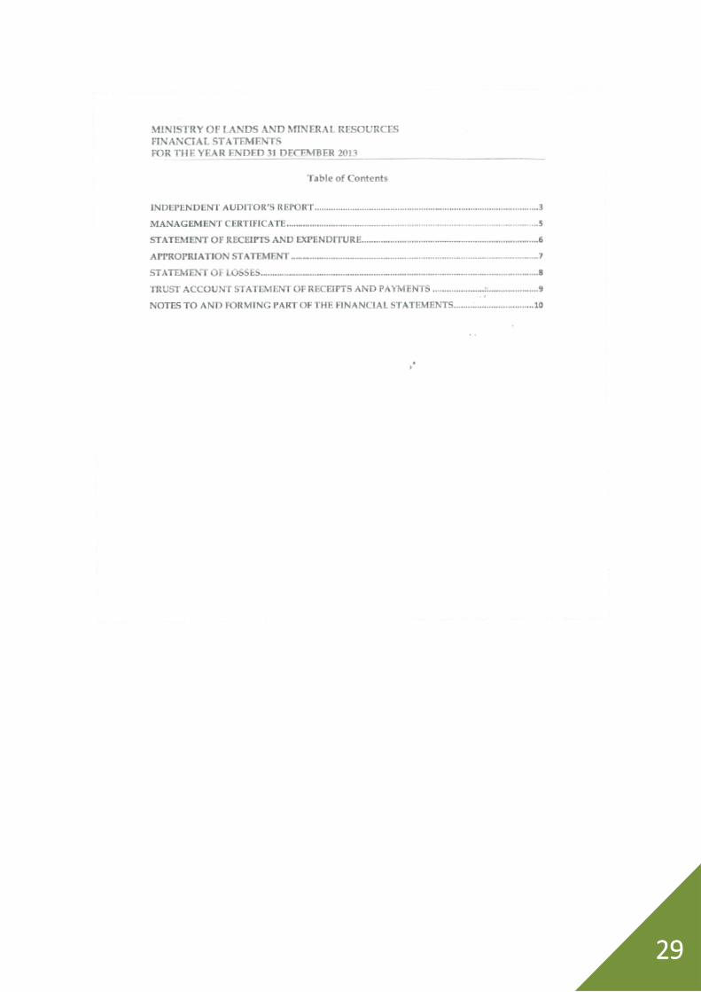
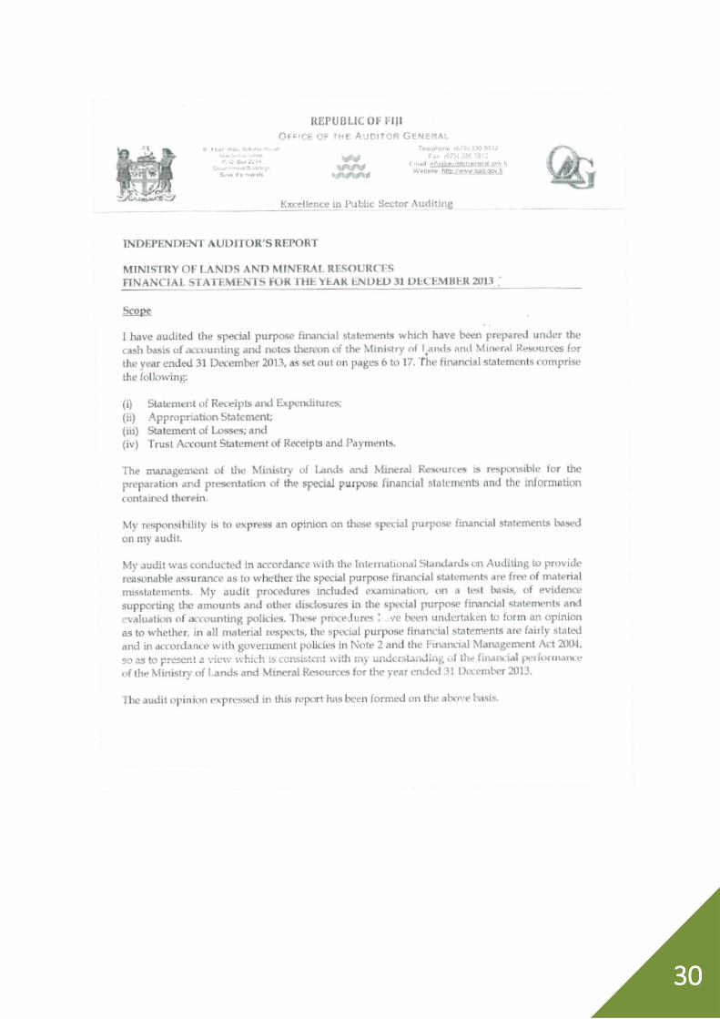
I. Independent Audit Report………………………………………...30
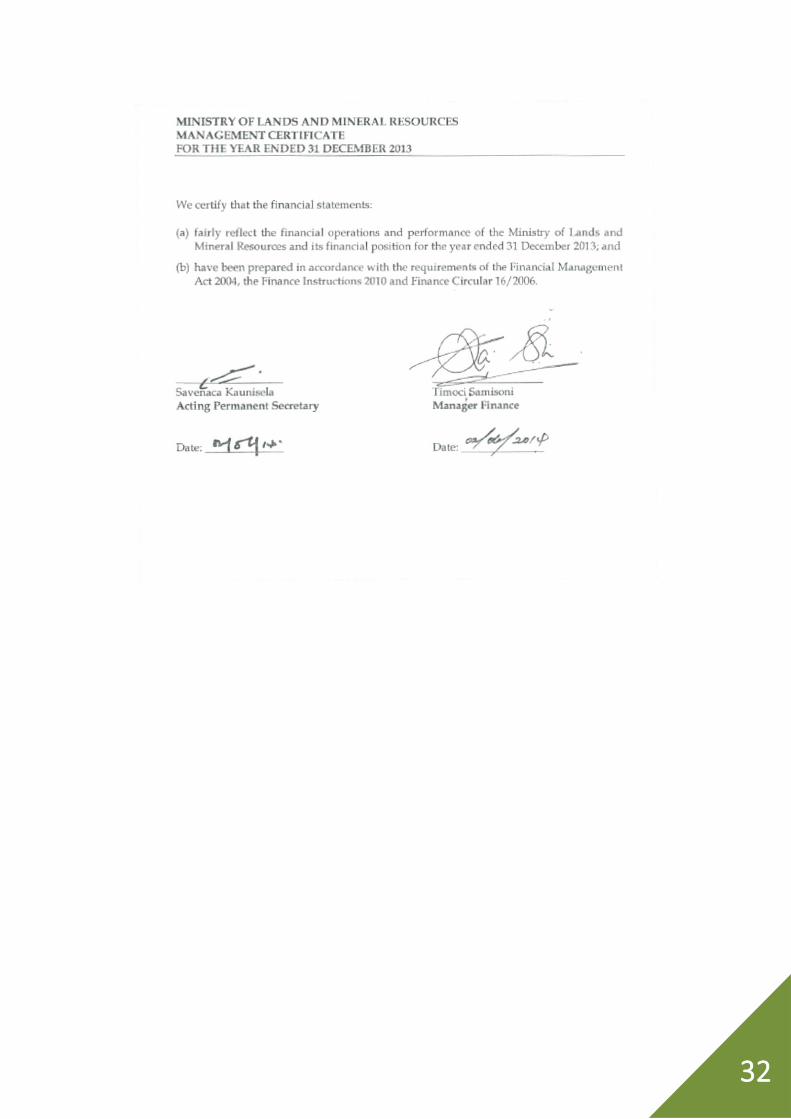
II. Management Certificate…………………………………………...32
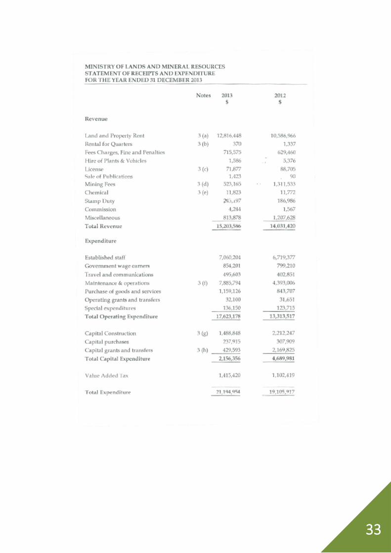
III. Statement of Receipts and Expenditure..........................................33
IV. Appropriation Statement…………………………………………..34
V. Statement of Losses………………………………………………...35
VI. Trust Account Statement of Receipts and Payments ……………36
VII. Notes to and forming part of the Financial Statements……….....37
CONSOLIDATED FINANCIAL STATEMENTS For the year ended 31st December 2013
15
27

28
29
30

31
32
33

34

35

36
37
38
39
40

41
42
43
44
45
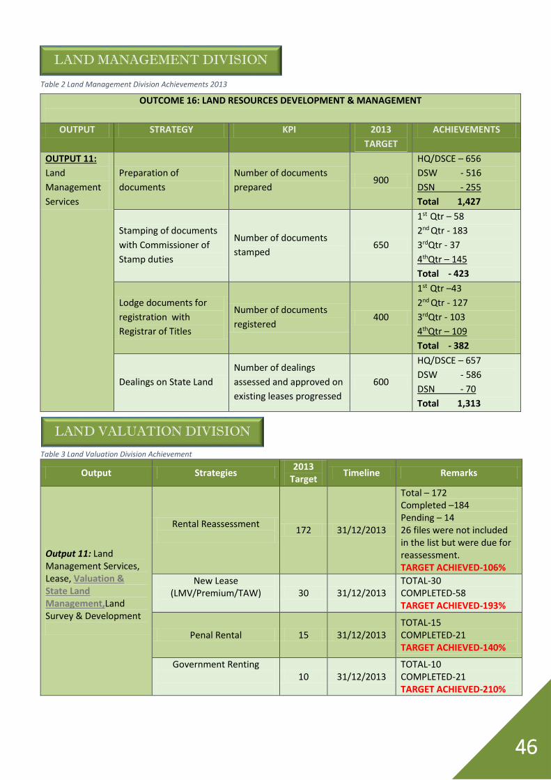
Table 1 Land Use Division Achievements 2013
ACTIVITIES 1ST QUARTER 2ND QUARTER 3RD QUARTER 4TH QUARTER TOTAL
Public Awareness
Public Awareness
& Consultation
with Landowners
10 7 9 5 31
Consultation with
Investors /
Tenants
7 5 2 1 15
Interests
Registered to
lease
3 6 8 55 72
Designation of Land
Number of Land
Designated 7 5 5 3 20
Area Designated 1328.591 ha 164.237ha 226.837ha 171.0114 ha 1890.6764
Leasing
Number of I
Taukei land leased - 1 - 1 2
State
Freehold/Buy
Back
1 1 1 - 3
Surveying
Number of Survey
Plans lodged for
Examinations
- 4 4 2 10
Land Acquisitions
Number of Land
Acquisitions - - - 1 1
Compensation
Paid Out - - 2 1 3
Number of
Valuation 1 - 3 - 4
Trainings
Number of
Trainings 1 - - - 1
Conference/
Workshops 3 - 2 3 8
FACTS & FIGURES 16
LAND USE DIVISION
46
Table 2 Land Management Division Achievements 2013
Table 3 Land Valuation Division Achievement
Output Strategies 2013
Target Timeline Remarks
Output 11: Land Management Services, Lease, Valuation & State Land Management,Land Survey & Development
Rental Reassessment
172 31/12/2013
Total – 172 Completed –184 Pending – 14 26 files were not included in the list but were due for reassessment. TARGET ACHIEVED-106%
New Lease (LMV/Premium/TAW)
30 31/12/2013
TOTAL-30 COMPLETED-58 TARGET ACHIEVED-193%
Penal Rental 15 31/12/2013 TOTAL-15 COMPLETED-21 TARGET ACHIEVED-140%
Government Renting
10 31/12/2013 TOTAL-10 COMPLETED-21 TARGET ACHIEVED-210%
OUTCOME 16: LAND RESOURCES DEVELOPMENT & MANAGEMENT
OUTPUT STRATEGY KPI 2013
TARGET
ACHIEVEMENTS
OUTPUT 11:
Land
Management
Services
Preparation of
documents
Number of documents
prepared 900
HQ/DSCE – 656
DSW - 516
DSN - 255
Total 1,427
Stamping of documents
with Commissioner of
Stamp duties
Number of documents
stamped 650
1st Qtr – 58
2nd Qtr - 183
3rdQtr - 37
4thQtr – 145
Total - 423
Lodge documents for
registration with
Registrar of Titles
Number of documents
registered 400
1st Qtr –43
2nd Qtr - 127
3rdQtr - 103
4thQtr – 109
Total - 382
Dealings on State Land
Number of dealings
assessed and approved on
existing leases progressed
600
HQ/DSCE – 657
DSW - 586
DSN - 70
Total 1,313
LAND MANAGEMENT DIVISION
LAND VALUATION DIVISION
47
Figure 1 Mineral Investigation Project at Rakiraki
Figure 2 Mineral Investigation Project at Ovalau
GEOLOGICAL SURVEY DIVISION
48
Table 4 List of Community Boreholes drilled & status
Borehole No: Commencement
& Completion Dates
Locations Depth
(m) Drill Rig Updates
1 13/01 11/02 – 13/03/13 Veivatuloa Parish, Lobau, Namosi
20 GEMCO Drilling Successful
2 13/03 13/03 – 28/03/13 Veivatuloa Parish, Lobau, Namosi
17 GEMCO Drilling Successful
3 13/05 09/09 – 24/09/13 Naluwai FCDCL Chilling Centre, Naitasiri
70 TONE 300 Drilling Successful
4 13/07 Waibunabuna 55 TONE 200 Drilling Successful
5 13/12 21/10 – 06/11/13 Livanisasa, Ba 70 TONE 300 Drilling Successful
6 13/13 11/11 – 27/11/13 Varavu, Ba 40 TONE 300 Drilling Successful
7 13/14 03/12 – 11/12/13 Vatuvula Primary School, Tawake, Cakaudrove
20 Ross Drill Rig
Drilling Successful
8 13/16 28/10 – 06/11/13 Nagasauva village, Tawake, Cakaudrove
15 Ross Drill Rig
Drilling Successful
9 13/09 30/06 – 12/07/13 Nagasauva village, Tawake, Cakaudrove
30 Ross Drill Rig
Low groundwater yield
10 13/15 07/08 – 22/08/13 Nagasauva village, Tawake, Cakaudrove
35 Ross Drill Rig
Low groundwater yield
11 13/02 05/04 – 03/05/13 Bureivanua District School, Ra
51 TONE 300 Well development and groundwater evaluation pending
12 13/04 8/05 – 14/05/13 Soa village, Ra 70 TONE 300 Well development and groundwater evaluation pending
13 13/06 26/09 – 18/10/13 Salvation Army, Lomaivuna, Naitasiri
70 GEMCO First attempt unsuccessful, second attempt pending
14 13/17 02/12 – 12/12/13 Balevuto, Ba 70 TONE 300 Low groundwater yield, well was abandoned
15 13/08 14/06 – 28/06/13 Nagasauva village, Tawake, Cakaudrove
25 Ross Drill Rig
Low groundwater yield, well was abandoned
Table 5 Geotech drill holes and locations
Location RIG No. of holes:
Vunidawa Sports Complex EHV 3300 2
Korovou Sports Complex EHV 3300 1
Waila City and Trunk Road EHV 3300 6
Raiwai proposed city complex EHV 3300 6
Princess Road propsed integrated
residential complex EHV 3300
5
TOTAL 20
GEOLOGICAL SERVICES DIVISION
49
Table 6 Number of project assessments conducted
Project Assessment No.
Inspections conducted for mines development 7
Underground safety inspections at Vatukoula
Gold Mines Ltd (VGML) 2
Conducted Safety inspections on quarries 22
Quarry Closure issued (Laqere, Lomolomo) 2
Conducted tenement site visits 23
Mineral Export permits issued 278
Gold & Silver permits issued 48
Bauxite Export permits issued 9
Manganese Export permit issued 1
Prospector’s rights issued 55
Table 7 Production of Gold (Au) and Silver (Ag) for 2012/2013
2012 2013
Weight (oz.) Value (FJD) Weight (oz.) Value (FJD)
42,209.1 $ 132,805,724.04 37,687.6 $ 95,709,675.04
12,084.3 $ 596,549.10 13,101.6 $ 551,591.71
57,293.4 $ 133,402,273.14 50,789.3 $ 96,261,266.75
Table 8 Production of Bauxite for 2012/2013
2012 2013
Volume Revenue Volume
Bauxite wet tons 335,721 $11,951,661.90 Bauxite wet tons 335,721
Bauxite dry tons 284,945 $10,142,207.39 Bauxite dry tons 284,945
MINES DIVISION
50
Table 9 Revenue collected for the year 2013 (Mines Division)
No: Revenue Revenue Collected ($)
1 Renewal Fees 137,241.62
2 Mining Trust Fund Revenue 353,085.56
3 Explosives 14,074.75
4 Fireworks 19,455.25
5 Flares 225.25
6 Firearms 309.20
7 Matches 254.25
8 Prospectors Right 2,810.50
9 Blaster’s Licence 2,488.25
10 Restricted Quarryman 316.30
11 Hoist Drivers 51.20
12 Quarryman 168.75
13 Mine Manager 146.90
14 Other Revenue 454.96
51
Table 10 Overseas Training Attended
OVERSEAS TRAINING ATTENDED
No Officer Training Location Funding
1. Apisai Vulawalu Lands Officer- HQ
Planning and Management of Sustainable Cities
New Delhi, India 15th Jan to 11th Mar, 2013
PSC
2. Asheeshwant Dayal Surveyor -DSN
Planning and Management of Sustainable Cities
New Delhi, India 15th Jan to 11th Mar, 2013
PSC
3. Lorosio Raikivi STO -FLIS
Advanced Certificate in Geographical Information System and its Application in Resource Planning
India 4th Feb to 29th March, 2013
PSC
4. Veniana Wainiqolo TO(II)
Advanced Certificate in Geographical Information System and its Application in Resource Planning
India 4th Feb to 29th March, 2013
PSC
5. Samulea Naicegucegu DLU
Regional Workshop on Geo referenced Disaster Risk Management Information System in South East Asia
Bangkok, Thailand 20th -22nd Feb, 2013
6. Malakai Finau DMD
Deep Sea Mineral Law and and Contract Negotiations
Tonga 11th -15th Mar,2013
SOPAC
7. Semi Bolalailai Senior Scientific Officer
Deep Sea Mineral Law and and Contract Negotiations
Tonga 11th -15th March, 2013
SOPAC
8. Akanisi Kini TO(II) Land Use
Application Development using GIS and Remote Sensing
4th Feb to 26th Apr, 2013 India
PSC
9. Lia Tuivuya TO(II) Land Use
Application Development using GIS and Remote Sensing
4th Feb to 26th Apr, 2013 India
PSC
10. Akata Takala, A/AGI
Forum on Global Geospatial Information Management and Global Map for Sustainable Development
24th April – 26th April 2013 China
Chinese Govt - fully funded
11. Filipe Waqabaca Basic Software Application Technology for Development Countries, China
25th Apr to 19th June, 2013
PSC
12 Asakaia Tabua, a/Principal Surveyor Control
Technical Seminar Reference Frame in Practice
21st -22nd June
13 Ani Tamata Groundwater Theory and Application Training, Korea
24th June to 9th July, 2013
14 Mosese Tagicakibau, Director Lands
Technical Seminar Reference Frame in Practice
21st -22nd June
15 Laisenia Rawace Seismology and Earthquake Engineering Course
24th July to 13th August, 2013
China
16 Samuela Naicegucegu Director Land Use
Conference on 3rd Session of the UN Committee of Experts on Global Geospatial Information Management
21st July to 27th July, 2013
UK
CORPORATE SERVICES DIVISION
52
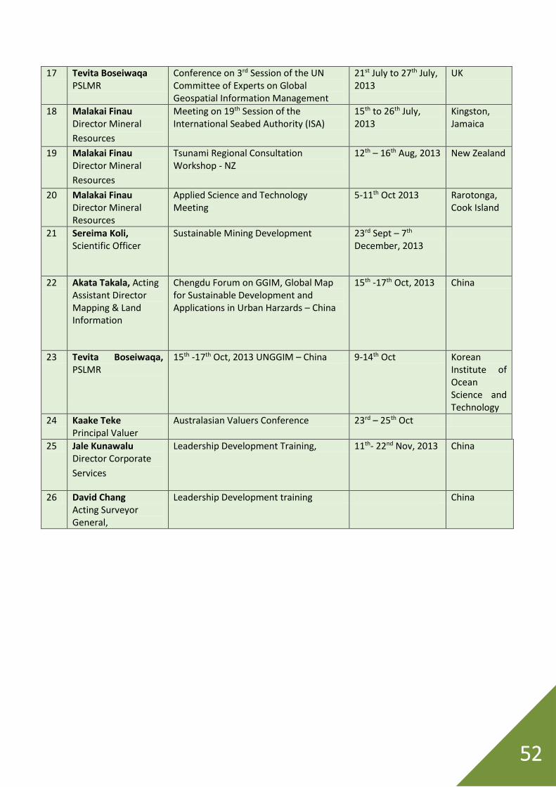
17 Tevita Boseiwaqa PSLMR
Conference on 3rd Session of the UN Committee of Experts on Global Geospatial Information Management
21st July to 27th July, 2013
UK
18 Malakai Finau Director Mineral
Resources
Meeting on 19th Session of the International Seabed Authority (ISA)
15th to 26th July, 2013
Kingston, Jamaica
19 Malakai Finau Director Mineral
Resources
Tsunami Regional Consultation Workshop - NZ
12th – 16th Aug, 2013 New Zealand
20 Malakai Finau Director Mineral Resources
Applied Science and Technology Meeting
5-11th Oct 2013 Rarotonga, Cook Island
21 Sereima Koli, Scientific Officer
Sustainable Mining Development 23rd Sept – 7th December, 2013
22 Akata Takala, Acting Assistant Director Mapping & Land Information
Chengdu Forum on GGIM, Global Map for Sustainable Development and Applications in Urban Harzards – China
15th -17th Oct, 2013 China
23 Tevita Boseiwaqa, PSLMR
15th -17th Oct, 2013 UNGGIM – China 9-14th Oct Korean Institute of Ocean Science and Technology
24 Kaake Teke Principal Valuer
Australasian Valuers Conference 23rd – 25th Oct
25 Jale Kunawalu Director Corporate
Services
Leadership Development Training, 11th- 22nd Nov, 2013 China
26 David Chang Acting Surveyor General,
Leadership Development training China
53
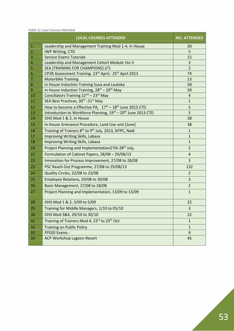
Table 11 Local Courses Attended
LOCAL COURSES ATTENDED NO. ATTENDED
1. Leadership and Management Training Mod 1-4, In House 30
2. IWP Writing, CTD 5
3. Service Exams Tutorials 15
4. Leadership and Management Cohort Module 1to 3 3
5. SEA [TRAINING FOR CHAMPIONS] JJ’S 2
6. CP2R Assessment Training- 23rd April,- 25th April 2013 74
7. Motorbike Training 13
8. In House Induction Training Suva and Lautoka 58
9. In House Induction Training, 28th – 29th May 39
10 Conciliators Training 22nd – 23rd May 4
11 SEA Best Practices, 30th -31st May 1
12 How to become a Effective PA, 17th – 18th June 2013 CTD 5
13 Introduction to Workforce Planning, 19th – 20th June 2013 CTD 5
14 OHS Mod 1 & 2, In House 38
15 In House Grievance Procedure, Land Use unit [June] 38
16 Training of Trainers 8th to 9th July, 2013, NTPC, Nadi 1
17 Improving Writing Skills, Labasa 1
18 Improving Writing Skills, Labasa 1
19 Project Planning and Implementation27th 28th July, 2
21 Formulation of Cabinet Papers, 28/08 – 29/08/13 4
22 Innovation for Process Improvement, 27/08 to 28/08 3
23 PSC Reach Out Programme, 27/08 to 29/08/13 132
24 Quality Circles, 22/08 to 23/08 2
25 Employee Relations, 29/08 to 30/08 3
26 Basic Management, 27/08 to 28/08 2
27 Project Planning and Implementation, 13/09 to 13/09 1
28 OHS Mod 1 & 2, 3/09 to 5/09 22
29 Training for Middle Managers, 1/10 to 05/10 3
30 OHS Mod 3&4, 29/10 to 30/10 22
31 Training of Trainers Mod 4, 23rd to 25th Oct 1
32 Training on Public Policy 1
33 FPSSD Exams - 9
34 ACP Workshop Lagoon Resort 45