Embed Size (px)
Citation preview
AGGREGATE OPERATORS
BEST MANAGEMENT PRACTICES HANDBOOK
for
BRITISH COLUMBIA
VOLUME I
Introduction and
Planning
(Volume II - Best Management Practices as separate printable document)
MINISTRY OF
ENERGY & MINES
April 2002
Aggregate Operators Best Management Practices Handbook for British Columbia i
Table of Contents
PART I - Introduction Chapter 1 INTRODUCTION Introduction .......................................................................................................................................1
How to Use This Handbook- A Step-by-Step Approach ..............................................................1 What are Best Management Practices (BMPs) ...........................................................................2
Chapter 2 COMMON COMMUNITY AND ENVIRONMENTAL CONCERNS Common Community and Environmental Concerns ........................................................................3
Community Context......................................................................................................................3 Environmental Concerns..............................................................................................................4
Water Management .................................................................................................................6 Stormwater...............................................................................................................................6 Surface Water ..........................................................................................................................6 Groundwater ............................................................................................................................6 Water Quality ...........................................................................................................................9 Water Discharge ......................................................................................................................9 Acid Rock Drainage and Quarrying .........................................................................................9 Habitat....................................................................................................................................10 Site Specific Environmental Impact Factors ..........................................................................10
Conclusion..................................................................................................................................12
Tables and Figures
Image CEC - 1: Fast growing poplar hybrids on a gravel pit's landscape berm in Sechelt, British Columbia. ......................................................................3
Table CEC - 2: Common community concerns...............................................................4 Table CEC - 3: Common environmental concerns .........................................................5 Table CEC - 4: Aggregate activities and their potential environmental concerns...........6 Figure CEC - 5: Example water budget for an aggregate operation................................8 Table CEC - 6: Discharge options for excess water at aggregate operations................9 Table CEC - 7: Water quality implications of aggregate operations. ............................11
Chapter 3 PLAYERS, PERMITS AND LEGISLATION Players, Permits and Legislation ....................................................................................................14 BC Aggregate Regulatory Framework............................................................................................15 BC Aggregate Permitting Framework.............................................................................................16 Fisheries and Oceans Canada (DFO)............................................................................................17 Environment Canada (EC) .............................................................................................................19 Ministry of Energy and Mines (MEM) .............................................................................................20
Aggregate Operators Best Management Practices Handbook for British Columbia ii
Ministry of Forests (MOF)...............................................................................................................21 Minister of Sustainable Resource Management (MSRM) ..............................................................22 Ministry of Water, Land and Air Protection (MWLAP) ....................................................................24 Ministry of Transportation (MOT)....................................................................................................25 Local Government ..........................................................................................................................26
PART II - Planning Chapter 4 MINE PLANNING Mine Planning.................................................................................................................................28
Modular Approach to Mine Planning..........................................................................................28 Mine Planning - A Four-Step Process........................................................................................30
Step 1 - Scope .......................................................................................................................30 Step 2 - Research ..................................................................................................................30 Step 3 - Planning ...................................................................................................................30 Step 4 - Assembly..................................................................................................................30
Maps - The Key Planning Tool...................................................................................................33 Common Map Features .........................................................................................................33 Site Location / Access Map....................................................................................................35 Local Features Map ...............................................................................................................35 Mine Plan / Extraction Map....................................................................................................36 Reclamation / Post Extraction Land Use Map .......................................................................36
Tables and Figures
Image MP - 1: Modules can apply to various portions of amine plan, and BMPs can be used in a number of modules. .....................................................28
Table MP - 2: Mine planning modules and their sections. .............................................29 Table MP - 3: Helpful mine planning information. ..........................................................31 Table MP - 4: Mine plan activity and module worksheet................................................32 Table MP - 5: Basic & other commonly required map elements...................................34 Table MP - 6: Common types of aggregate permit application maps............................35
Chapter 5 - 1: Planning Modules EXTRACTION MODULE - EM EXTRACTION MODULE - EM .......................................................................................................38
Common Concerns: Extraction .................................................................................................38 Extraction Planning ....................................................................................................................38
Mine-Life Extraction Planning ................................................................................................38 Short-Term Extraction Planning.............................................................................................38 Production and Non-Production Related Planning ................................................................38
Extraction Planning: Key Pointers.............................................................................................40 Using Maps to Detail Extraction Plans...................................................................................40 Matching Extraction Planning to Proven Reserves and Proposed Product ..........................40 Start-up Space Problem.........................................................................................................40 Visibility ..................................................................................................................................40 Working Top Down ................................................................................................................41 Straight Short Haul-Roads.....................................................................................................41
Aggregate Operators Best Management Practices Handbook for British Columbia iii
Keeping It Dry ........................................................................................................................41 Clearing & Grubbing ..............................................................................................................42 Blasting ..................................................................................................................................42 Extract to Reclamation...........................................................................................................42 Benching ................................................................................................................................43
Tables and Figures
Table EM - 1: Production related extraction planning considerations............................39 Table EM - 2: Non- Production related extraction planning considerations...................39 Table EM - 3: Extraction activities and related modules and BMPs. .............................43 Figure EM - 4: Sample extraction map............................................................................44
Chapter 5 - 2: Planning Modules PROCESSING MODULE - PM PROCESSING MODULE - PM.......................................................................................................45
Common Concerns: Aggregate Processing..............................................................................45 Addressing Processing Plant Concerns.....................................................................................45
Processing Plant Location .................................................................................................45 Plant Type..........................................................................................................................46 The Processing Plant Flow Sheet .....................................................................................46
Tables and Figures
Table PM - 1: Basic types of processing plants. ............................................................46 Figure PM - 2: Example of a Processing Plant Flow Sheet for a 500 ton per hour (tph)
plant. ...........................................................................................................47 Table PM - 3: Typical processing plant equipment and components and related
potential noise, dust and visual issues. ......................................................48 Table PM - 4: Concerns, requirements and by-products of aggregate processing
plants. .........................................................................................................49
Chapter 5 - 3: Planning Modules STOCKPILING MODULE - SM STOCKPILING MODULE - SM ......................................................................................................50
Common Concerns: Stockpiling................................................................................................50 Basic Stockpiling: What and Where?.........................................................................................50 General Stockpiling Guidelines ..................................................................................................51
Tables and Figures
Image SM - 1: Stockpiles of aggregate. .............................................................................50 Table SM - 2: Aggregate products and storage options....................................................51 Table SM - 3: Stockpiling issues, significance, notes and suggested BMPs. ...................52
Chapter 5 - 4: Planning Modules TRAFFIC MODULE - TM TRAFFIC MODULE - TM............................................................................................................... 53
Aggregate Operators Best Management Practices Handbook for British Columbia iv
Common Concerns: Aggregate Truck Traffic .......................................................................... 53 On-Site Traffic ........................................................................................................................... 53
Noise, Dust and Visual Impact Considerations of On-Site Traffic ........................................ 53 Managing On-Site Aggregate Traffic .................................................................................... 55 Considerations for On-Site Traffic Planning: ........................................................................ 55
Off-Site Traffic ........................................................................................................................... 55 Managing Off-Site Aggregate Traffic .................................................................................... 56 Considerations for Off-Site Traffic Planning: ........................................................................ 57
Tables and Figures
Table TM - 1: On-site traffic BMPs to reduce dust, noise and visual impacts .....................54 Table TM - 2: Off-site aggregate traffic concerns and mitigating BMPs and other
measures .......................................................................................................56 Table TM - 3: Suggested off-site truck traffic actions, by applicable organization...............57
Chapter 5 - 5: Planning Modules STORMWATER & EROSION MODULE - SECM STORMWATER & EROSION CONTROL MODULE - SECM........................................................58
Common Concerns: Stormwater & Erosion Control .................................................................58 Stormwater and Erosion Basics .................................................................................................59
Stormwater.............................................................................................................................59 Erosion...................................................................................................................................59
Erosion Control Pointers ............................................................................................................59 Keep Existing Vegetation Intact.............................................................................................59 Limit Slope Steepness & Length............................................................................................60
Managing Stormwater & Erosion ...............................................................................................61 Stabilization Practices............................................................................................................61 Structural Practices................................................................................................................61 Inspections.............................................................................................................................61
Stormwater & Erosion Control Maps..........................................................................................63
Tables and Figures Figure SECM - 1: Types of water erosion on soils (topsoil, silt and clay).........................59 Figure SECM - 2: Effect of vegetation on stormwater runoff. ...........................................60 Table SECM - 3: Strategies and BMPs for erosion and sedimentation control...............61 Table SECM - 4: Stormwater and erosion control issues for aggregate operation
and recommended BMPs.....................................................................62 Table SECM - 5: Suggested features for a stormwater & erosion control map...............63
Chapter 5 - 6: Planning Modules BY-PRODUCT & WASTE MODULE - BWM BY-PRODUCT & WASTE MODULE - BWM ..................................................................................64
Common Concerns: Aggregate By-products & Waste..............................................................64 What Are Aggregate By-products ..............................................................................................64
By-products Are Not Waste ...................................................................................................65 By-Product Storage Options ..................................................................................................65
What Are Aggregate Wastes......................................................................................................67 Managing Aggregate By-products..............................................................................................68

Aggregate Operators Best Management Practices Handbook for British Columbia v
Minimizing Production of Aggregate By-products..................................................................68 Planning for Sufficient Handling and Storage Space.............................................................68 Finding Uses for Aggregate By-products...............................................................................68
1. Immediate On-Site Uses/Applications ......................................................................68 2. Immediate Off-Site Uses/Applications ......................................................................68 3. On-Site Storage with Delayed Uses/Applications.....................................................69
Managing Aggregate Wastes.....................................................................................................69
Tables and Figures
Table BWM - 1: Potential by-products generated at aggregate operations........................65 Table BWM - 2: Aggregate by-products significance, storage, and application options.....66 Table BWM - 3: Potential types of general wastes at an aggregate operation...................67 Table BWM - 4: Definition of “air contaminant” and “effluent”.............................................67 Image RWM - 5: Spreading muck for an agricultural application.........................................68 Figure BWM - 6: Recycling Council of British Columbia contact information.......................69 Table BWM - 7: Aggregate wastes and handling options. ..................................................70
Chapter 5 - 7: Planning Modules SITE LAYOUT MODULE - SLM SITE LAYOUT MODULE - SLM .....................................................................................................71
Common Concerns: Site Layout ...............................................................................................71 Noise......................................................................................................................................71 Dust........................................................................................................................................71 Visual Landscape Design ......................................................................................................71
Section 1 - Noise ............................................................................................................................72 Aggregate Operation Noise Management .................................................................................72 Understanding Noise..................................................................................................................72 Common Aggregate Operation Noise Considerations...............................................................75
Existing Noise Levels.............................................................................................................75 Site Location ..........................................................................................................................75 Equipment and Activities........................................................................................................75 Site Layout and Plant Location ..............................................................................................75
Noise Management ....................................................................................................................76 Working with the Public on Noise Management ....................................................................76 Methods For Reducing And Controlling Noise.......................................................................77 Noise Planning Considerations..............................................................................................77
Section 2 - Dust ..............................................................................................................................79 Understanding Dust....................................................................................................................79
Size Fractions of Aggregate Dust ..........................................................................................79 Dust Generation.....................................................................................................................80 Dust Travel Distances............................................................................................................82 Dust Impact............................................................................................................................82
Dust Management ......................................................................................................................82 Methods For Reducing And Controlling Dust ........................................................................82 Dust Planning Considerations ...............................................................................................84
Section 3 - Visual Landscape Design.............................................................................................85 Understanding Visual Landscape Design ..................................................................................85
Visual Impacts: Types and Sources ......................................................................................85 Managing Visual Landscapes ....................................................................................................86
Visual Landscape Evaluations...............................................................................................86 Reducing Visual Impacts .......................................................................................................87 Visual Landscape Planning Considerations ..........................................................................87
Aggregate Operators Best Management Practices Handbook for British Columbia vi
Tables and Figures
Figure SLM - 1: Noise levels from common sources ..........................................................73 Table SLM - 2: Projected un-buffered noise levels for some common aggregate
machinery..................................................................................................73 Table SLM - 3: Common noise generating activities at aggregate operations..................74 Figure SLM - 4: Noise attenuation provided by different barriers .......................................76 Table SLM - 5: Site layout, operations and interception noise control options..................78 Table SLM - 6: Example statistic of fugitive dust sources in the USA...............................79 Table SLM - 7: Common concerns with aggregate dust by size category. .......................79 Table SLM - 8: Sample study of USA dust emissions from aggregate storage ................80 Table SLM - 9: Common dust generating activities at aggregate operations and
suggested controls measures ...................................................................81 Table SLM - 10: Typical travel distances for dust by size fraction ......................................82 Table SLM - 11: Control options for dust at aggregate sites ...............................................83 Table SLM - 12: Efficiency of dust control measures ..........................................................84 Table SLM - 13: Potential sources of visual impacts at an aggregate site..........................86 Table SLM - 14: Overview of key viewpoint visual landscape approach.............................86 Table SLM - 15: Suggested control strategies for reducing the visual impact of
aggregate operations ................................................................................88
Chapter 5 - 8: Planning Modules RISK MANAGEMENT MODULE - RRM RISK MANAGEMENT MODULE - RMM ....................................................................................... 89 Section 1 - Risk.............................................................................................................................. 90
Understanding Risk ................................................................................................................... 90 Identifying Risk .......................................................................................................................... 91 Risk Management ..................................................................................................................... 92
Risk Management Planning.................................................................................................. 92 Section 2 - Emergency & Spill Response...................................................................................... 93
Emergency and Spill Response (ESR) ..................................................................................... 93 Company Information............................................................................................................ 93 Emergency and Spill Response (ESR) Site Map ................................................................. 93 Marshalling Area Establishment ........................................................................................... 94 Hazard and Hazardous Material Review .............................................................................. 94 Prevention Measures and BMPs .......................................................................................... 94
Spill Prevention................................................................................................................. 95 Emergency prevention...................................................................................................... 96
Summary of Roles and Responsibilities ............................................................................... 97 Emergency Systems And Equipment ................................................................................... 98 Emergency Response Guidelines ........................................................................................ 98 Listing of Emergency Telephone numbers ........................................................................... 99 Emergency Response Training ............................................................................................ 99 Notification and Reporting Requirements ........................................................................... 100
Containment and Clean-up Techniques/Options .................................................................... 101 Section 3 - Employee Training .................................................................................................... 103
General Training Considerations ............................................................................................ 103 Basic Training Program ...................................................................................................... 103 Compliance with Permit Conditions .................................................................................... 103 Best Management Practices............................................................................................... 104
Training Guidelines ................................................................................................................. 104 Section 4 - Identifying Potential Environmental Risks................................................................. 106
Aggregate Operators Best Management Practices Handbook for British Columbia vii
What Are Identified Environmental Features .......................................................................... 106 How to find out if there are Identified Environmental Features........................................... 107
Section 5 - Community Relations ................................................................................................ 108
Tables and Figures
Table RRM - 1: Key risk terms..........................................................................................90 Figure RMM - 2: The degree of risk is a product of the likelihood of an event times
the consequence .....................................................................................90 Table RMM - 3: Common risk categories and consequences at aggregate operations ...91 Table RMM - 4: Strategies and options for managing risk at aggregate sites ..................92 Figure RMM - 5: Suggested access-restricting signage.....................................................92 Table RMM - 6: Example hazardous material identification sheet * .................................94 Table RMM - 7: Operational hazards identification sheet .................................................95 Table RMM - 8: Sample spill prevention planning check list.............................................95 Table RMM - 9: Sample emergency prevention planning check list .................................96 Table RMM - 10: Sample Emergency and Disaster Identification, Prevention and
Protection Form.......................................................................................96 Table RMM - 11: Emergency and Spills Response Plan (ESRP) typical roles and
responsibilities .........................................................................................97 Table RMM - 12: Sample emergency telephone and contact information sheet ................99 Figure RMM - 13: Sample MWLAP spill report form ..........................................................100 Table RMM - 14: Guide to selecting containment techniques for spills on water .............101 Table RMM - 15: Guide to selecting containment techniques for spills on land ...............101 Table RMM - 16: Guide to selecting cleanup techniques for spills on land ......................102 Table RMM - 17: Suggestions for identifying aggregate operation employee training
needs.....................................................................................................104 Table RMM - 18: Sample “training needs” evaluation form...............................................105 Table RMM - 19: Sources for ordering TRIM maps ..........................................................106 Table RMM - 20: Examples of environmental features and primary contact agencies.....107 Table RMM - 21: Contact agencies for possible environmental features .........................108
Chapter 5 - 9: Planning Modules BMP MONITORING MODULE - BMM BMP Monitoring Module - BMM....................................................................................................109
Who Needs a BMP Monitoring Plan.........................................................................................109 What is BMP Monitoring...........................................................................................................109 Collecting the Information ........................................................................................................110 When to Monitor .......................................................................................................................112 Setting up a Monitoring Program .............................................................................................112
Tables and Figures
Table BMM - 1: Sample inspection category options for BMP monitoring.........................109 Table BMM - 2: Options for collecting monitoring information on dust plumes from
traffic .........................................................................................................110 Table BMM - 3: Sample BMP effectiveness monitoring tracking sheet .............................111 Table BMM - 4: Key steps to establishing a BMP effectiveness monitoring program .......112
Aggregate Operators Best Management Practices Handbook for British Columbia viii
Chapter 6 RECLAMATION Reclamation..................................................................................................................................113
Reclamation Strategies ............................................................................................................113
Table R - 1: General reclamation strategies ......................................................................114
PART III - Best Management Practices Chapter 7 Best Management Practices Introduction ...................................................................................................................................115 How to Choose BMPs ..................................................................................................................115
1. Refer to Table 7-1 and 7-2 BMP Module Reference Charts.......................................115 2. Review Topical Modules for Suggestions ...................................................................115 3. Flip Through the BMPs ...............................................................................................115
Additional BMP Websites .............................................................................................................116 Appendices Appendix 1 Aggregate Glossary.....................................................................119 Appendix 2 Salmonid Life Histories and Habitat Requirements
Salmonid Life Histories and Habitat Requirements ...............................................................123 Salmonid Life Histories ..................................................................................................123 Salmonid Habitat Requirements ....................................................................................124
Water Temperature ...................................................................................................125 Dissolved Oxygen (DO) ............................................................................................125 Water Clarity and Suspended Sediment...................................................................125 Stream Substrate ......................................................................................................125 Riparian Cover and Stream Structure.......................................................................125 Access.......................................................................................................................126 Stream Flow ..............................................................................................................126
Tables and Figures
Image A2 - 1: Generalized life cycle of anadromous salmonids. ...................................... 123
Appendix 3 Recommended Readings and Internet Resources ............... 128 Appendix 4 Aggregate & Government Acronyms...................................... 133
Aggregate Operators Best Management Practices Handbook for British Columbia ix
Foreword The foundations of our communities are literally built out of aggregate. In British Columbia, about 11 tonnes of sand, gravel and crushed rock per person per year are used to maintain infrastructure such as roads, sewers and utilities. An additional 2 to 4 tonnes are used for the construction of new homes, public and commercial buildings and schools. All told, the annual per capita consumption of aggregate in BC is about 14 tonnes -- the equivalent of one fully loaded dump truck. British Columbia has abundant sand, gravel and quarry rock resources. Many of our communities have local aggregate resources that can supply their own consumption needs well into the foreseeable future. These deposits are formed and transported by natural geological process and cannot be relocated. The extraction of aggregate from deposits located within and adjacent to local communities often leads to social and environmental conflicts. The aggregate industry largely develops local resources for local markets. Aggregate is needed as the raw material for building and maintaining a community’s infrastructure and buildings, and it is least expensive when extracted, processed and distributed locally. Aggregate operations can be significant contributors to the provincial and local economies. The 1998 provincial production value for construction aggregate was more than $400 million dollars, greater than that of gold production for the same period. This handbook provides technical information, guidance and best management practice options to sand and gravel pit and rock quarry operators for many aspects of planning, operating and reclaiming aggregate operations in British Columbia. Best Management Practices (BMPs) are tried and true solutions to common pit and quarry issues, challenges and problems. Using the BMPs and the other planning tools described in this handbook may help producers supply the aggregate needs of local communities while supporting local economies, respecting neighbourhood values, and operating with environmental responsibility. Incorporating BMPs into an aggregate operation may:
• provide for effective, economical and safe stormwater management and discharge, • provide for effective and safe erosion and sediment control, • reduce siltation of aquatic habitats and storm water conveyance systems, • control dust through minimizing exposed soil areas, re-establishing vegetation and
promoting the use of buffers, • aid in the planning, design and implementation of settling ponds for process water and
the proper disposal of the resultant mud, • control noise emissions through strategic placement of points sources and buffering
structures, and reductions in transient noise generating activities, • discourage garbage dumping at aggregate operation sites, • provide pollution control through equipment management and maintenance, proper
fuel handling, spill avoidance and emergency planning, • aid in planning for and implementation of reclamation for subsequent land uses,
Aggregate Operators Best Management Practices Handbook for British Columbia x
• promote an ethic of environmental responsibility and land use stewardship, • reduce traffic conflicts through planning and driving protocols, and • aid in reducing visual interruptions thought site layout and design.
This handbook was written and compiled by the British Columbia Ministry of Energy and Mines (MEM), with the assistance of a dedicated committee of stakeholders. The authors have drawn heavily on previous work by aggregate producers and professionals from around the world.
Acknowledgments The Ministry of Energy and Mines acknowledges the contributions of time, ideas and general guidelines provided by the members of the steering committee. These members are: Thom Sedun (chair) - Ministry of Energy & Mines Paul Allard - Aggregate Producers Association of British Columbia Oliver Baker - Ministry of Forests Rob Buchannan - Ministry of Transportation Ted Carlson - Aggregate Producers Association of British Columbia Jim Duckworth - City of Abbotsford Lloyd Gerbrant - Aggregate Producers Association of British Columbia Bob Hart - Ministry of Sustainable Resource Management John Heinonen - Fisheries & Oceans Canada David Ingelson - Land & Water British Columbia Bob Lapham - Regional District of Nanaimo Ken Lukawesky - Ministry of Transportation Barry McLean - Aggregate Producers Association of British Columbia Ken Nelson - Ministry of Forests Charles Newcombe - Ministry of Water, Land and Air Protection David Pow - Ministry of Energy & Mines Ed Regts - City of Abbotsford
Aggregate Operators Best Management Practices Handbook for British Columbia xi
Disclaimer ANY PERSON CHOOSING TO EMPLOY ANY OF THE PRACTICES SET OUT IN THIS HANDBOOK DOES SO AT THEIR OWN RISK, AND THAT PERSON ASSUMES FULL RESPONSIBILITY FOR ANY AND ALL CONSEQUENCES ARISING FROM THE USE OF THOSE PRACTICES. The Aggregate Operator's Best Management Practices Handbook for British Columbia (Handbook) is intended as a general guide to assist aggregate operators. As a general guide, the practices set out in this Handbook may not be appropriate for all circumstances. Accordingly, users of this Handbook must use their own judgement as to whether the practices set out in this Handbook are appropriate for any particular situation. The Province of British Columbia, Fisheries and Oceans Canada, and every level of government, agency, organization and company represented on the Aggregate Handbook Steering Committee (the Province and the Contributors) expressly deny any liability or responsibility for any and all consequences arising from the use of the practices set out in this Handbook. The Province and the Contributors also specifically deny any express or implied warranty concerning the thoughts, ideas and practices set out in this Handbook, and do not warranty that the thoughts, ideas and practices set out in this Handbook are adequate for the reader’s purposes in general or for the reader’s compliance with local, provincial, or federal laws concerning sand and gravel mining and rock quarrying. Any use of trade, product, or firm names is for descriptive purposes only and does not imply endorsement.
Aggregate Operators Best Management Practices Handbook for British Columbia 1
PART I
Chapter 1 Introduction
This handbook was prepared to assist aggregate operators in understanding common concerns associated with aggregate operations and to help them in planning and selecting Best Management Practices to effectively manage those concerns. The principle advice of this handbook is to plan ahead, plan carefully, operate responsibly and reclaim with an eye to subsequent land uses. Anticipating challenges is considerably more cost effective than trying to compensate after the fact. This BMP handbook is designed to be a practical, user-friendly reference and learning tool for all aggregate producers in British Columbia. It includes both thorough discussions of BMP options and quick references in the form of tables and illustrations. It can be used to assist in both mine planning and day-to-day operations. Readers are referred to the glossary (Appendix 1) for explanations of terms, and the acronym chart (Appendix 4) for the long hand versions of organization names or phrases. The detailed planning, operating and reclaiming of an aggregate operation, especially in the case of larger mines, can be a complex multidisciplinary task that goes far beyond the scope of this handbook. Trained professionals such as agrologists, biologists, geoscientists, engineers, environmental scientists, hydrogeologists, landscape architects, planners and soil scientists may be helpful in designing and managing a project. Aggregate producer associations, trade and other government publications, government agencies and equipment suppliers may also have to be consulted. For more detailed advice on pit and quarry reclamation, it is recommended that operators refer to the Reclamation and Environmental Protection Handbook for Sand, Gravel and Quarry Operations in British Columbia, available from the Ministry of Transportation.
How to Use This Handbook- A Step-by-Step Approach This handbook is divided into two parts. Part One discusses in general terms the broader aspects of planning and operating aggregate sites. It includes discussions of environmental protection issues and the interests of various stakeholders. Part Two focuses on the “how to” of planning and operating to avoid safety, land use and environmental problems. After introducing the basics of preparing a mine plan and related maps, it presents nine modules covering such topics as noise, stockpiling and traffic. Each module is a self-contained guide for a particular topic. Ideally, all of the modules should be useful in planning an
Aggregate Operators Best Management Practices Handbook for British Columbia 2
operation. Through work tables, the modules suggest ranges of BMP options adaptable to individual sites.
What are Best Management Practices BMPs are managerial, operational, and structural measures that can be used to prevent, reduce or mitigate various undesired impacts that an operation may cause. Examples may include:
• a treed berm that is used as a visual screen and to intercept dust and noise, • scheduling of clearing to avoid nesting seasons, and • the practice of reducing the height from which aggregate is dropped into trucks to reduce
both dust and noise. Each of the Infosheets in Chapter 7 of this handbook describes one BMP. BMPs can be used individually or in combination, and in a wide variety of applications. To be effective, BMPs must be used appropriately and with competence. As the BMP Infosheets are simply tools for doing things more effectively, they do not always apply and do not replace legislation or regulations. Unlike the Chapter 5 modules, they are intended to be used selectively. Each situation should be individually assessed and BMPs chosen to suit the uniqueness of the operation.
All of British Columbia's Provincial statutes and associated regulations can be found on the Internet at http://www.qp.gov.bc.ca/statreg/ Regulations detail how statutes are enforced by the Provincial ministries responsible for each particular statute.
To assist with selecting BMPs, this handbook includes numerous tables that present a range of BMP options. In Chapter 7, all BMPs have in their top right hand corner a "USER" list of potential applications.
Aggregate Operators Best Management Practices Handbook for British Columbia 3
Chapter 2 Common Community and Environmental Concerns
This chapter briefly reviews common community and environmental concerns with respect to aggregate production, as background for later chapters that discuss ways of addressing those concerns.
Community Context Common community concerns regarding aggregate operations include:
• Noise • Dust • Traffic • Appearance (Viewscape) • Hours of operation • Water management
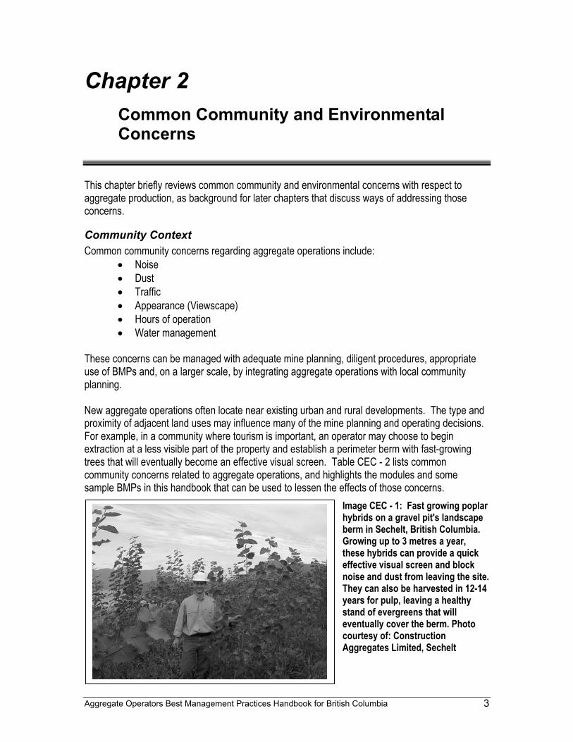
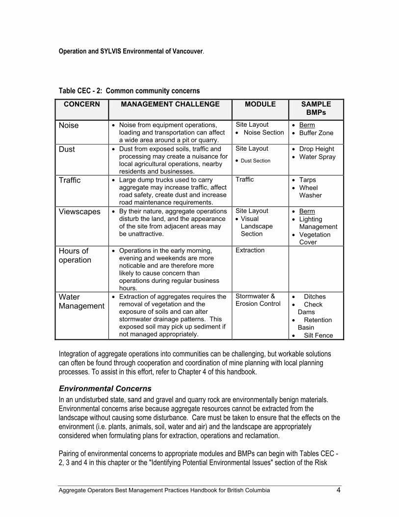
These concerns can be managed with adequate mine planning, diligent procedures, appropriate use of BMPs and, on a larger scale, by integrating aggregate operations with local community planning. New aggregate operations often locate near existing urban and rural developments. The type and proximity of adjacent land uses may influence many of the mine planning and operating decisions. For example, in a community where tourism is important, an operator may choose to begin extraction at a less visible part of the property and establish a perimeter berm with fast-growing trees that will eventually become an effective visual screen. Table CEC - 2 lists common community concerns related to aggregate operations, and highlights the modules and some sample BMPs in this handbook that can be used to lessen the effects of those concerns.
Image CEC - 1: Fast growing poplar hybrids on a gravel pit's landscape berm in Sechelt, British Columbia. Growing up to 3 metres a year, these hybrids can provide a quick effective visual screen and block noise and dust from leaving the site. They can also be harvested in 12-14 years for pulp, leaving a healthy stand of evergreens that will eventually cover the berm. Photo courtesy of: Construction Aggregates Limited, Sechelt
Aggregate Operators Best Management Practices Handbook for British Columbia 4
Operation and SYLVIS Environmental of Vancouver.
Table CEC - 2: Common community concerns
CONCERN MANAGEMENT CHALLENGE MODULE SAMPLE BMPs
Noise • Noise from equipment operations, loading and transportation can affect a wide area around a pit or quarry.
Site Layout • Noise Section
• Berm • Buffer Zone
Dust • Dust from exposed soils, traffic and processing may create a nuisance for local agricultural operations, nearby residents and businesses.
Site Layout
• Dust Section
• Drop Height • Water Spray
Traffic • Large dump trucks used to carry aggregate may increase traffic, affect road safety, create dust and increase road maintenance requirements.
Traffic • Tarps • Wheel
Washer
Viewscapes • By their nature, aggregate operations disturb the land, and the appearance of the site from adjacent areas may be unattractive.
Site Layout • Visual
Landscape Section
• Berm • Lighting
Management • Vegetation
Cover Hours of operation
• Operations in the early morning, evening and weekends are more noticable and are therefore more likely to cause concern than operations during regular business hours.
Extraction
Water Management
• Extraction of aggregates requires the removal of vegetation and the exposure of soils and can alter stormwater drainage patterns. This exposed soil may pick up sediment if not managed appropriately.
Stormwater & Erosion Control
• Ditches • Check
Dams • Retention
Basin • Silt Fence
Integration of aggregate operations into communities can be challenging, but workable solutions can often be found through cooperation and coordination of mine planning with local planning processes. To assist in this effort, refer to Chapter 4 of this handbook.
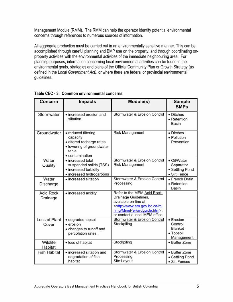
Environmental Concerns In an undisturbed state, sand and gravel and quarry rock are environmentally benign materials. Environmental concerns arise because aggregate resources cannot be extracted from the landscape without causing some disturbance. Care must be taken to ensure that the effects on the environment (i.e. plants, animals, soil, water and air) and the landscape are appropriately considered when formulating plans for extraction, operations and reclamation. Pairing of environmental concerns to appropriate modules and BMPs can begin with Tables CEC - 2, 3 and 4 in this chapter or the "Identifying Potential Environmental Issues" section of the Risk
Aggregate Operators Best Management Practices Handbook for British Columbia 5
Management Module (RMM). The RMM can help the operator identify potential environmental concerns through references to numerous sources of information. All aggregate production must be carried out in an environmentally sensitive manner. This can be accomplished through careful planning and BMP use on the property, and through coordinating on-property activities with the environmental activities of the immediate neighbouring area. For planning purposes, information concerning local environmental activities can be found in the environmental goals, strategies and plans of the Official Community Plan or Growth Strategy (as defined in the Local Government Act), or where there are federal or provincial environmental guidelines.
Table CEC - 3: Common environmental concerns Concern Impacts Module(s) Sample
BMPs Stormwater • increased erosion and
siltation Stormwater & Erosion Control • Ditches
• Retention Basin
Groundwater • reduced filtering
capacity • altered recharge rates • lowering of groundwater
table • contamination
Risk Management • Ditches • Pollution
Prevention
Water Quality
• increased total suspended solids (TSS)
• increased turbidity • increased hydrocarbons
Stormwater & Erosion Control Risk Management
• Oil/Water Separator
• Settling Pond • Silt Fence
Water Discharge
• increased siltation Stormwater & Erosion Control Processing
• French Drain • Retention
Basin Acid Rock Drainage
• increased acidity Refer to the MEM Acid Rock Drainage Guidelines, available on-line at <http://www.em.gov.bc.ca/mining/MinePer/ardguide.htm>, or contact a local MEM office.
Loss of Plant Cover
• degraded topsoil • erosion • changes to runoff and
percolation rates.
Stormwater & Erosion Control Stockpiling
• Erosion Control Blanket
• Topsoil Management
Wildlife Habitat
• loss of habitat Stockpiling • Buffer Zone
Fish Habitat • increased siltation and degradation of fish habitat
Stormwater & Erosion Control Processing Site Layout
• Buffer Zone • Settling Pond • Silt Fences
Aggregate Operators Best Management Practices Handbook for British Columbia 6
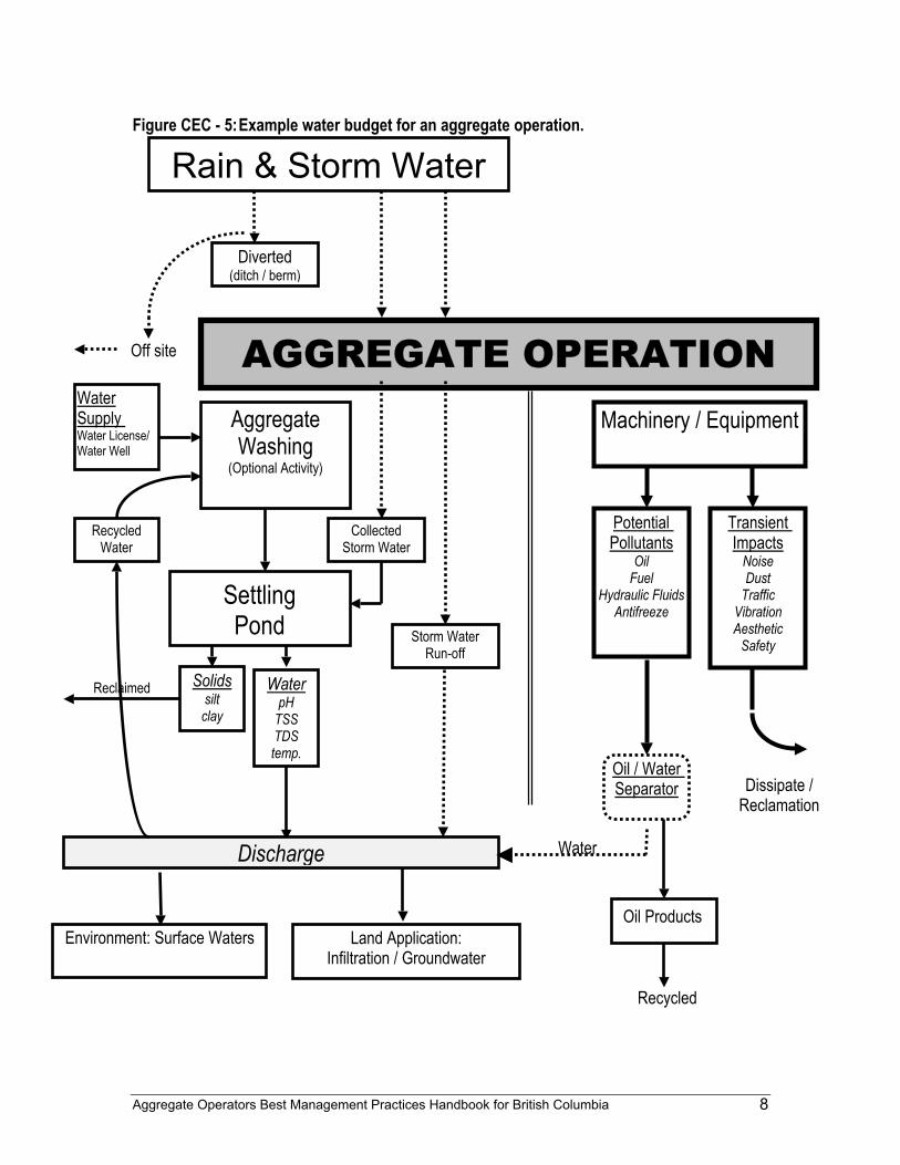
Water Management Water management is often the most significant environmental concern at an aggregate site. This concern includes stormwater management, groundwater and surface water protection, and discharge options for stormwater and process water. An illustration of a water budget, showing how water can pass through an aggregate operation, is depicted in figure CEC - 5.
Stormwater "Stormwater" is the portion of rainfall or snowmelt that does not immediately percolate into the ground or evaporate. Stormwater flowing across exposed soils can pick up fine clays and silt which, if not managed properly, will negatively impact offsite water quality. For further discussion of stormwater management on aggregate sites and its potential environmental concerns, please refer to the Stormwater and Erosion Control Module.
Surface Water "Surface water" is water that flows in streams and rivers, or is stored in natural lakes, ponds, wetlands and human made reservoirs. This water can be used for any number of applications from agriculture to drinking water. Extreme care should be exercised whenever aggregate operations interact with surface waters. For discussions on pollution prevention, refer to the Risk Management Module, "Emergency and Spill Response" section, and related BMPs. Operations that use, or are located in the vicinity of surface waters must comply with the Water Act. For water use, either a licence (for long-term use) or a section 8 approval (for short-term use) is required. For any construction or resource development in or about a stream, a section 9 approval is required in the case of major works (diversions, rip rapping), and a notification form outlining the proposed work must be submitted in the case of minor works. The federal Fisheries Act may also apply if an operation is likely to affect a fishery.
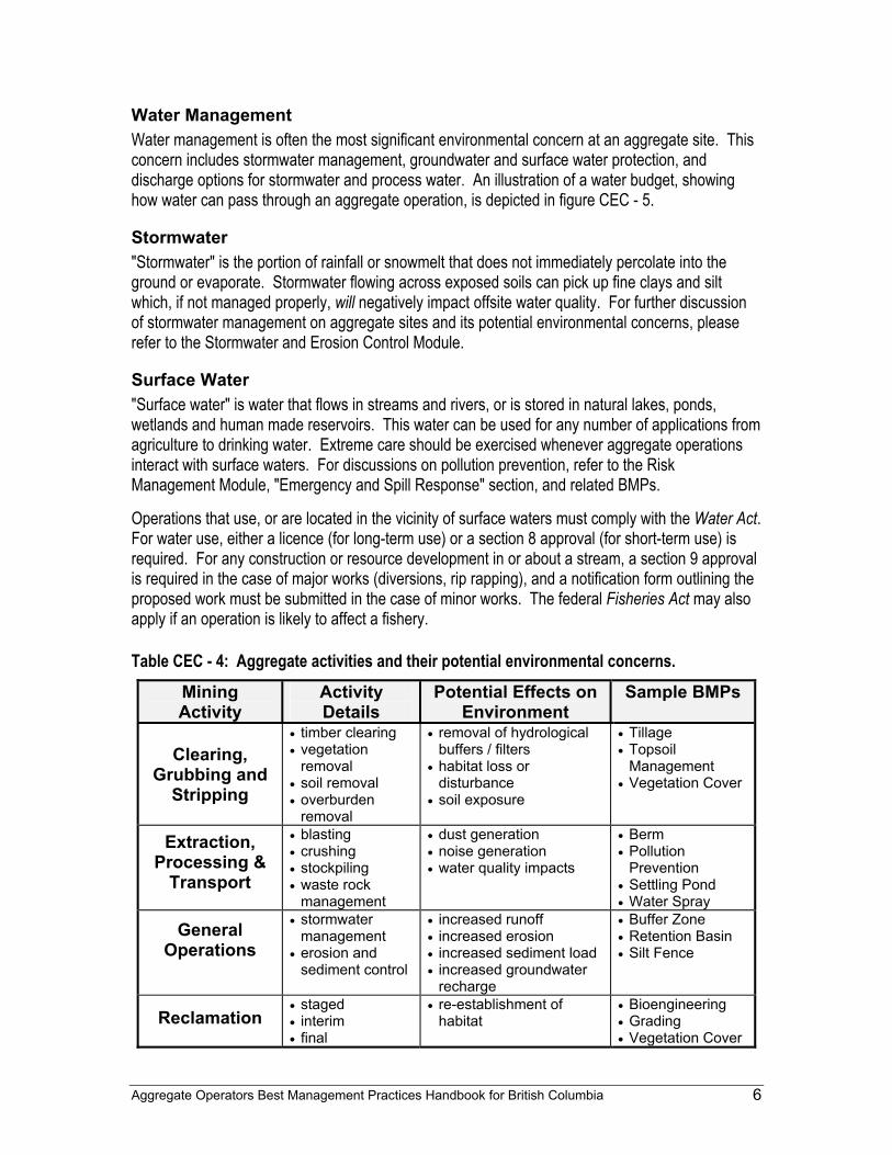
Table CEC - 4: Aggregate activities and their potential environmental concerns. Mining Activity
Activity Details
Potential Effects on Environment
Sample BMPs
Clearing,
Grubbing and Stripping
• timber clearing • vegetation
removal • soil removal • overburden
removal
• removal of hydrological buffers / filters
• habitat loss or disturbance
• soil exposure
• Tillage • Topsoil
Management • Vegetation Cover
Extraction, Processing &
Transport
• blasting • crushing • stockpiling • waste rock
management
• dust generation • noise generation • water quality impacts
• Berm • Pollution
Prevention • Settling Pond • Water Spray
General Operations
• stormwater management
• erosion and sediment control
• increased runoff • increased erosion • increased sediment load • increased groundwater
recharge
• Buffer Zone • Retention Basin • Silt Fence
Reclamation • staged • interim • final
• re-establishment of habitat
• Bioengineering • Grading • Vegetation Cover
Aggregate Operators Best Management Practices Handbook for British Columbia 7
Groundwater Sand and gravel pits do not always contaminate groundwater either directly or indirectly, but may increase the risk of groundwater contamination by removing vegetation and soil buffers. Assessments should always be made on a case-by-case basis. The potential impact of an aggregate operation on a groundwater system depends upon a number of factors, including:
• presence of a groundwater source below an operation, • characteristics of the groundwater system, • characteristics of the gravel deposit and operation, • thickness of the overburden, • presence of clay or bedrock immediately under the sand and gravel deposit, and • climate.
Potential Effects of Aggregate Production on Groundwater:
1. Decreased Safety Margin for Pollution Prevention - By reducing the thickness of unsaturated sediments above the groundwater table, an aggregate operation may affect the ability of those sediments to ameliorate contaminants. The use of operational practices such as regular maintenance, proper fuel handling, spill avoidance, use of spill kits and emergency planning will keep contamination as low as possible. These measures can be planned using the "Stormwater, Emergency and Spill Response" section of the Risk Management Module and the Traffic Module from this handbook. These provisions should be described in the Notice of Work and Reclamation application for sand and gravel pit and rock quarry permits.
2. Altered Groundwater Recharge Rates - Vegetation, together with soil, may act as both
a filter and a sponge and has the potential to return almost all rainfall to the atmosphere, allowing as little as 10% to become groundwater. When that filter and sponge capacity is removed due to a disturbance, there may be an increase in both the volume and rate of recharge into a groundwater system from the disturbed area. Recharge rates are also affected by the clay and silt content of the gravel deposit and the direction of the surface drainage with respect to the site.
3. Lowering of Groundwater Table - An aggregate operation can lower the groundwater
table if excavation occurs at a depth below the average high table. In British Columbia, this situation rarely occurs because most aggregate operating permits prohibit excavation within one metre of the high groundwater table. Surface watercourses and groundwater have a complex yet balanced relationship. During low flow periods that relationship can be crucial in ensuring adequate water is supplied to rivers to support aquatic ecosystems. The average depth to the groundwater table is required information in the Notice of Work and Reclamation application for sand and gravel pit and rock quarry permit.
Aggregate Operators Best Management Practices Handbook for British Columbia 8
Figure CEC - 5: Example water budget for an aggregate operation.
AGGREGATE OPERATION
Rain & Storm Water
Diverted (ditch / berm)
Off site
Aggregate Washing
(Optional Activity)
Collected Storm Water
Storm Water Run-off
Machinery / Equipment Water Supply Water License/ Water Well
Settling Pond
Water pH
TSS TDS temp.
Discharge
Recycled Water
Environment: Surface Waters Land Application: Infiltration / Groundwater
Potential Pollutants
Oil Fuel
Hydraulic Fluids Antifreeze
Transient Impacts
Noise Dust
Traffic Vibration Aesthetic
Safety
Solids silt clay
Reclaimed
Dissipate / Reclamation
Oil / Water Separator
Oil Products
Recycled
Water
Aggregate Operators Best Management Practices Handbook for British Columbia 9
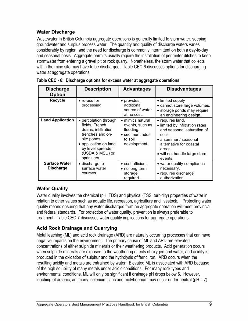
Water Discharge Wastewater in British Columbia aggregate operations is generally limited to stormwater, seeping groundwater and surplus process water. The quantity and quality of discharge waters varies considerably by region, and the need for discharge is commonly intermittent on both a day-to-day and seasonal basis. Aggregate permits usually require the installation of perimeter ditches to keep stormwater from entering a gravel pit or rock quarry. Nonetheless, the storm water that collects within the mine site may have to be discharged. Table CEC-6 discusses options for discharging water at aggregate operations. Table CEC - 6: Discharge options for excess water at aggregate operations.
Discharge Option
Description Advantages Disadvantages
Recycle • re-use for processing.
• provides additional source of water at no cost.
• limited supply • cannot store large volumes. • storage ponds may require
an engineering design. Land Application • percolation through
fields, French drains, infiltration trenches and on-site ponds.
• application on land by level spreader (USDA & MSU) or sprinklers.
• mimics natural events, such as flooding.
• sediment adds to soil development.
• requires land. • limited by infiltration rates
and seasonal saturation of soils.
• a summer / seasonal alternative for coastal areas.
• will not handle large storm events.
Surface Water Discharge
• discharge to surface water courses.
• cost efficient. • no long term
storage required.
• water quality compliance necessary.
• requires discharge authorization.
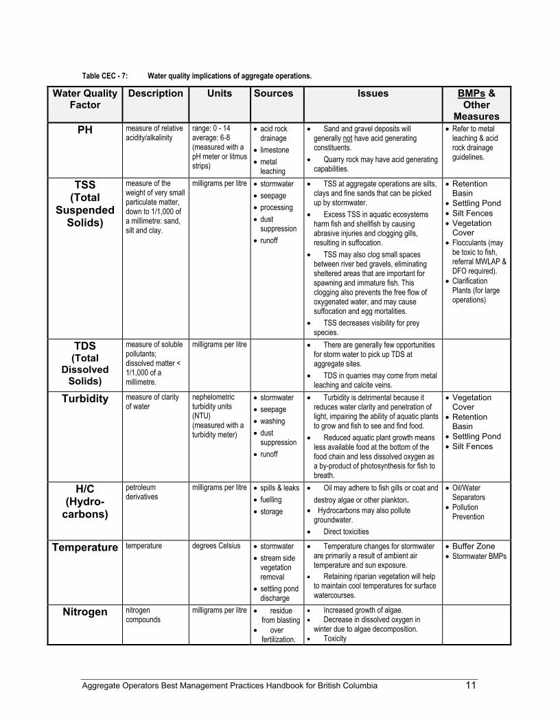
Water Quality Water quality involves the chemical (pH, TDS) and physical (TSS, turbidity) properties of water in relation to other values such as aquatic life, recreation, agriculture and livestock. Protecting water quality means ensuring that any water discharged from an aggregate operation will meet provincial and federal standards. For protection of water quality, prevention is always preferable to treatment. Table CEC-7 discusses water quality implications for aggregate operations.
Acid Rock Drainage and Quarrying Metal leaching (ML) and acid rock drainage (ARD) are naturally occurring processes that can have negative impacts on the environment. The primary cause of ML and ARD are elevated concentrations of either sulphide minerals or their weathering products. Acid generation occurs when sulphide minerals are exposed to the weathering effects of oxygen and water, and acidity is produced in the oxidation of sulphur and the hydrolysis of ferric iron. ARD occurs when the resulting acidity and metals are entrained by water. Elevated ML is associated with ARD because of the high solubility of many metals under acidic conditions. For many rock types and environmental conditions, ML will only be significant if drainage pH drops below 6. However, leaching of arsenic, antimony, selenium, zinc and molybdenum may occur under neutral (pH = 7)
Aggregate Operators Best Management Practices Handbook for British Columbia 10
or alkaline (pH > 7) drainage conditions if the concentrations of these materials in the rock is sufficiently high. Because these operations usually target unaltered and unmineralized materials, ML and ARD are rarely an issue at aggregate operations, and infrequently at quarry operations . However, the potential for ML and ARD should always be considered both prior to aggregate development and during operations. Predicting ML and ARD usually involves the evaluation of geological characteristics of the materials to be excavated and analytical testwork. Potential indicators include visible sulphide mineralization, visual indications of sulphide oxidation or hydrothermal alteration (rusty or bleached appearance in the materials), and proximity to a known metallic mineral deposit. If any of these indicators are identified, the potential for ML and ARD should be investigated further. In general, materials with the potential for ML and ARD should not be used as a source of aggregate since they may be damaging to the environment, and could result in substantial expenses to the operator for removal costs and associated environmental liability issues. For more information on ML and ARD, contact the Mines Branch of the Ministry of Energy & Mines.
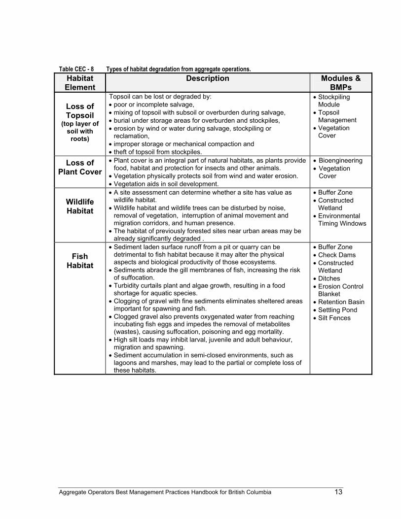
Habitat Mechanical disturbance at sand and gravel pits and rock quarries has the potential to disrupt wildlife habitat. Awareness of habitat types on the property, such as forest, grassland, etc., and their degree of significance (common, regionally significant and sensitive) can be helpful in planning to minimize disturbances. Habitat protection is preferable to habitat restoration (Murphy 1995). The "Identifying Potential Environmental Impacts" section in the Risk Management Module can aid in habitat identification. Table CEC - 8 lists general types of environmental and habitat degradation that can occur as a result of sand and gravel pits and rock quarry operations.
Site Specific Environmental Impact Factors British Columbia's environment ranges from rain forest to desert, and the potential environmental concerns regarding aggregate operations can vary tremendously. For example, storm water management is a significant issue in coastal British Columbia, whereas dust management is a major challenge in the dry Interior. Some other regional factors affecting environmental concerns are:
• rainfall • temperature • wind • habitat diversity • glacial history • urban development and agriculture • soil development • terrain
Aggregate Operators Best Management Practices Handbook for British Columbia 11
Table CEC - 7: Water quality implications of aggregate operations.
Water Quality Factor
Description Units Sources Issues BMPs & Other
Measures PH measure of relative
acidity/alkalinity range: 0 - 14 average: 6-8 (measured with a pH meter or litmus strips)
• acid rock drainage
• limestone • metal
leaching
• Sand and gravel deposits will generally not have acid generating constituents.
• Quarry rock may have acid generating capabilities.
• Refer to metal leaching & acid rock drainage guidelines.
TSS (Total
Suspended Solids)
measure of the weight of very small particulate matter, down to 1/1,000 of a millimetre: sand, silt and clay.
milligrams per litre • stormwater • seepage • processing • dust
suppression • runoff
• TSS at aggregate operations are silts, clays and fine sands that can be picked up by stormwater.
• Excess TSS in aquatic ecosystems harm fish and shellfish by causing abrasive injuries and clogging gills, resulting in suffocation.
• TSS may also clog small spaces between river bed gravels, eliminating sheltered areas that are important for spawning and immature fish. This clogging also prevents the free flow of oxygenated water, and may cause suffocation and egg mortalities.
• TSS decreases visibility for prey species.
• Retention Basin
• Settling Pond • Silt Fences • Vegetation
Cover • Flocculants (may
be toxic to fish, referral MWLAP & DFO required).
• Clarification Plants (for large operations)
TDS (Total
Dissolved Solids)
measure of soluble pollutants; dissolved matter < 1/1,000 of a millimetre.
milligrams per litre • There are generally few opportunities for storm water to pick up TDS at aggregate sites.
• TDS in quarries may come from metal leaching and calcite veins.
Turbidity measure of clarity of water
nephelometric turbidity units (NTU) (measured with a turbidity meter)
• stormwater • seepage • washing • dust
suppression • runoff
• Turbidity is detrimental because it reduces water clarity and penetration of light, impairing the ability of aquatic plants to grow and fish to see and find food.
• Reduced aquatic plant growth means less available food at the bottom of the food chain and less dissolved oxygen as a by-product of photosynthesis for fish to breath.
• Vegetation Cover
• Retention Basin
• Settling Pond • Silt Fences
H/C (Hydro-
carbons)
petroleum derivatives
milligrams per litre • spills & leaks • fuelling • storage
• Oil may adhere to fish gills or coat and destroy algae or other plankton.
• Hydrocarbons may also pollute groundwater.
• Direct toxicities
• Oil/Water Separators
• Pollution Prevention
Temperature temperature degrees Celsius • stormwater • stream side
vegetation removal
• settling pond discharge
• Temperature changes for stormwater are primarily a result of ambient air temperature and sun exposure.
• Retaining riparian vegetation will help to maintain cool temperatures for surface watercourses.
• Buffer Zone • Stormwater BMPs
Nitrogen nitrogen compounds
milligrams per litre • residue from blasting
• over fertilization.
• Increased growth of algae. • Decrease in dissolved oxygen in
winter due to algae decomposition. • Toxicity
Aggregate Operators Best Management Practices Handbook for British Columbia 12
Demographic and regional factors, such as local product specification, may also affect environmental concerns. For example, aggregates used in high-rise buildings and bridges will likely require sizing and washing, so more attention should be paid to dust issues and to discharging of sediments. Fill for a parking lot at a recreational site, on the other hand, may not require any processing. Site-specific concerns may also include property appearance, local groundwater potential and use, and proximity to environmentally sensitive areas.
Conclusion In planning and operating a pit or quarry, it is important to recognize community and environmental concerns. This handbook presents a range of options to help with the challenge of addressing those concerns appropriate for each site.
Aggregate Operators Best Management Practices Handbook for British Columbia 13
Table CEC - 8 Types of habitat degradation from aggregate operations.
Habitat Element
Description Modules & BMPs
Loss of Topsoil
(top layer of soil with
roots)
Topsoil can be lost or degraded by: • poor or incomplete salvage, • mixing of topsoil with subsoil or overburden during salvage, • burial under storage areas for overburden and stockpiles, • erosion by wind or water during salvage, stockpiling or
reclamation, • improper storage or mechanical compaction and • theft of topsoil from stockpiles.
• Stockpiling Module
• Topsoil Management
• Vegetation Cover
Loss of Plant Cover
• Plant cover is an integral part of natural habitats, as plants provide food, habitat and protection for insects and other animals.
• Vegetation physically protects soil from wind and water erosion. • Vegetation aids in soil development.
• Bioengineering • Vegetation
Cover
Wildlife Habitat
• A site assessment can determine whether a site has value as wildlife habitat.
• Wildlife habitat and wildlife trees can be disturbed by noise, removal of vegetation, interruption of animal movement and migration corridors, and human presence.
• The habitat of previously forested sites near urban areas may be already significantly degraded .
• Buffer Zone • Constructed
Wetland • Environmental
Timing Windows
Fish
Habitat
• Sediment laden surface runoff from a pit or quarry can be detrimental to fish habitat because it may alter the physical aspects and biological productivity of those ecosystems.
• Sediments abrade the gill membranes of fish, increasing the risk of suffocation.
• Turbidity curtails plant and algae growth, resulting in a food shortage for aquatic species.
• Clogging of gravel with fine sediments eliminates sheltered areas important for spawning and fish.
• Clogged gravel also prevents oxygenated water from reaching incubating fish eggs and impedes the removal of metabolites (wastes), causing suffocation, poisoning and egg mortality.
• High silt loads may inhibit larval, juvenile and adult behaviour, migration and spawning.
• Sediment accumulation in semi-closed environments, such as lagoons and marshes, may lead to the partial or complete loss of these habitats.
• Buffer Zone • Check Dams • Constructed
Wetland • Ditches • Erosion Control
Blanket • Retention Basin • Settling Pond • Silt Fences
Aggregate Operators Best Management Practices Handbook for British Columbia 14
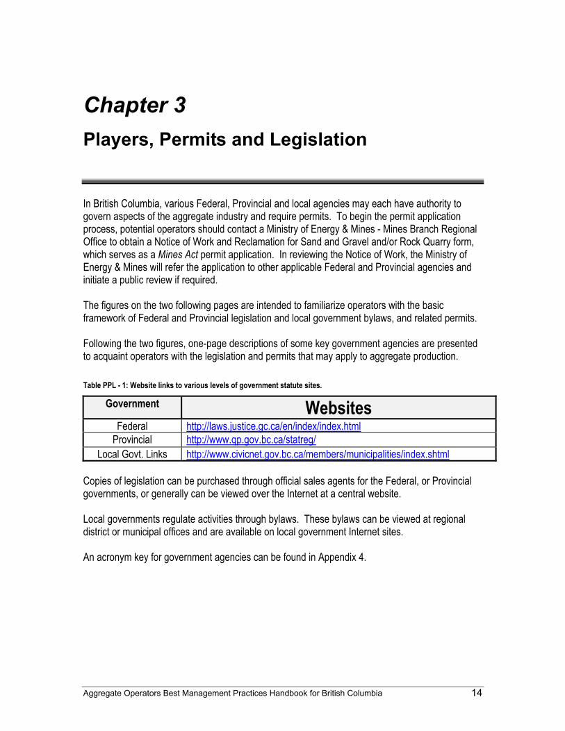
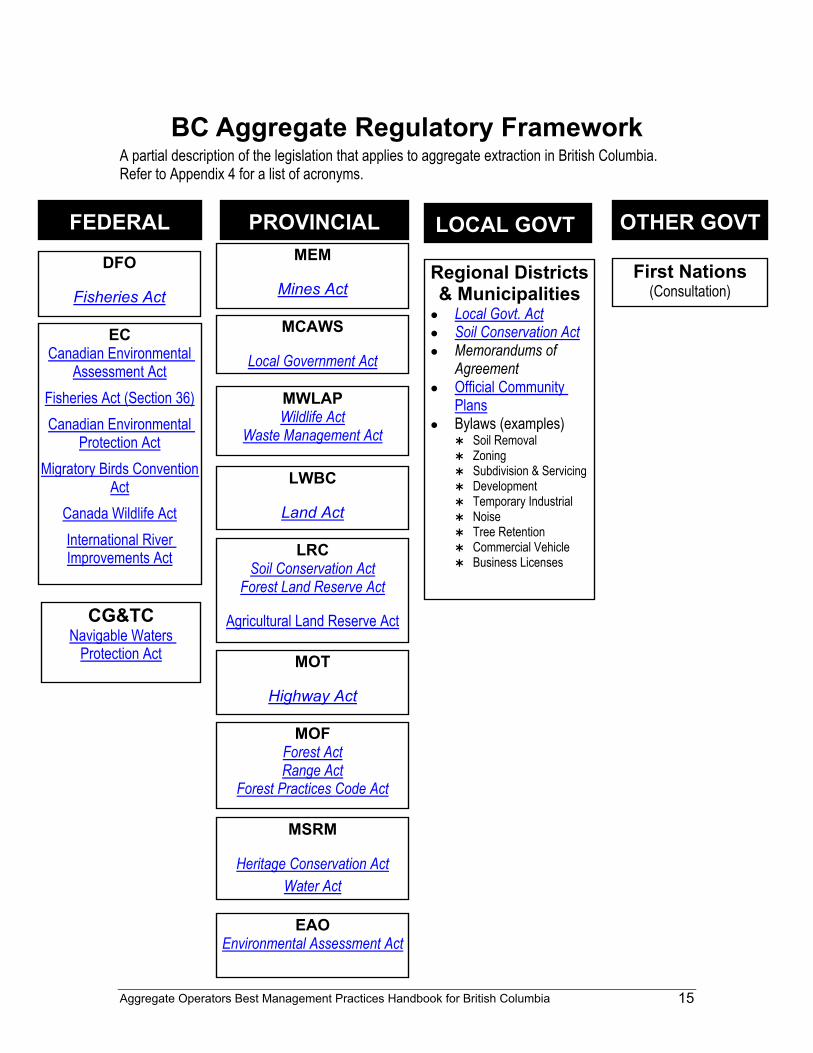
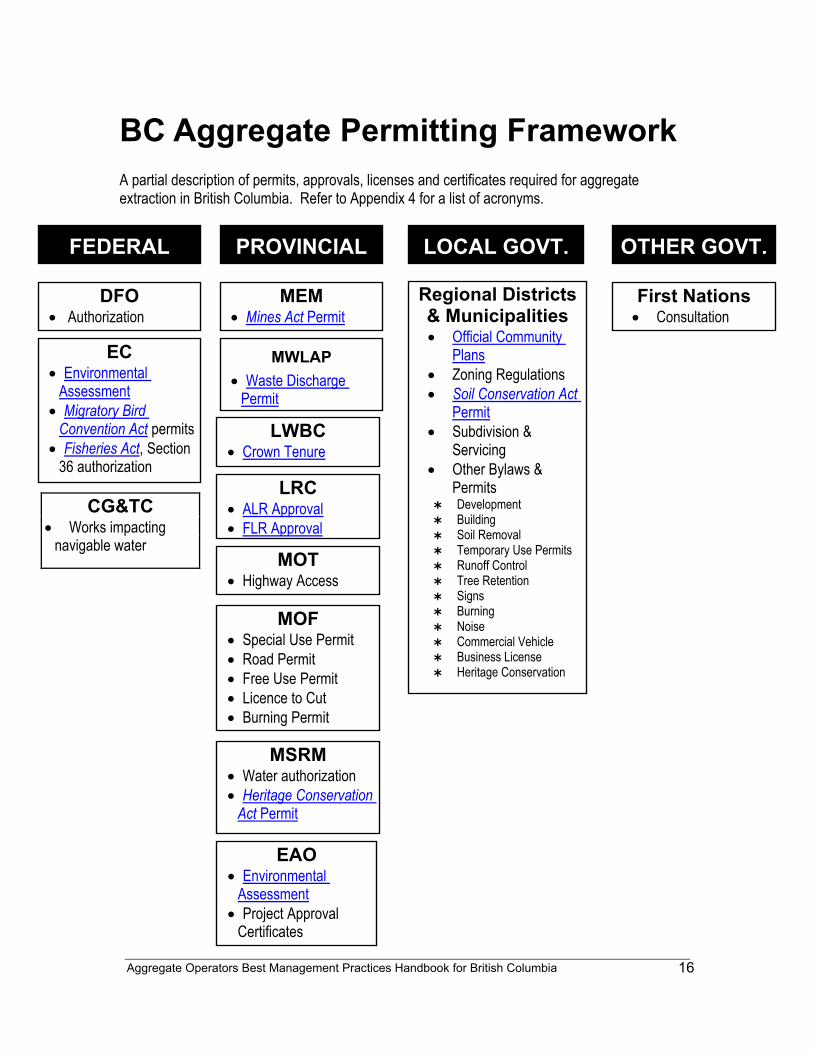
Chapter 3 Players, Permits and Legislation In British Columbia, various Federal, Provincial and local agencies may each have authority to govern aspects of the aggregate industry and require permits. To begin the permit application process, potential operators should contact a Ministry of Energy & Mines - Mines Branch Regional Office to obtain a Notice of Work and Reclamation for Sand and Gravel and/or Rock Quarry form, which serves as a Mines Act permit application. In reviewing the Notice of Work, the Ministry of Energy & Mines will refer the application to other applicable Federal and Provincial agencies and initiate a public review if required. The figures on the two following pages are intended to familiarize operators with the basic framework of Federal and Provincial legislation and local government bylaws, and related permits. Following the two figures, one-page descriptions of some key government agencies are presented to acquaint operators with the legislation and permits that may apply to aggregate production. Table PPL - 1: Website links to various levels of government statute sites.
Government Websites Federal http://laws.justice.gc.ca/en/index/index.html
Provincial http://www.qp.gov.bc.ca/statreg/ Local Govt. Links http://www.civicnet.gov.bc.ca/members/municipalities/index.shtml
Copies of legislation can be purchased through official sales agents for the Federal, or Provincial governments, or generally can be viewed over the Internet at a central website. Local governments regulate activities through bylaws. These bylaws can be viewed at regional district or municipal offices and are available on local government Internet sites. An acronym key for government agencies can be found in Appendix 4.
Aggregate Operators Best Management Practices Handbook for British Columbia 15
BC Aggregate Regulatory Framework A partial description of the legislation that applies to aggregate extraction in British Columbia. Refer to Appendix 4 for a list of acronyms.
FEDERAL PROVINCIAL OTHER GOVT LOCAL GOVT. DFO
Fisheries Act
MWLAP Wildlife Act
Waste Management Act
MCAWS
Local Government Act
MEM
Mines Act
LRC Soil Conservation Act
Forest Land Reserve Act
Agricultural Land Reserve Act
LWBC
Land Act
MSRM
Heritage Conservation Act Water Act
MOT
Highway Act
MOF Forest Act Range Act
Forest Practices Code Act
Regional Districts & Municipalities
● Local Govt. Act ● Soil Conservation Act ● Memorandums of
Agreement ● Official Community
Plans ● Bylaws (examples)
Soil Removal Zoning Subdivision & Servicing Development Temporary Industrial Noise Tree Retention Commercial Vehicle Business Licenses
First Nations(Consultation)
EC Canadian Environmental
Assessment Act Fisheries Act (Section 36) Canadian Environmental
Protection Act Migratory Birds Convention
Act Canada Wildlife Act International River Improvements Act
CG&TC Navigable Waters
Protection Act
EAO Environmental Assessment Act
Aggregate Operators Best Management Practices Handbook for British Columbia
16
BC Aggregate Permitting Framework A partial description of permits, approvals, licenses and certificates required for aggregate extraction in British Columbia. Refer to Appendix 4 for a list of acronyms.
CG&TC • Works impacting
navigable water
FEDERAL PROVINCIAL OTHER GOVT. LOCAL GOVT.
DFO • Authorization
MWLAP • Waste Discharge
Permit
MEM • Mines Act Permit
LRC • ALR Approval • FLR Approval
LWBC • Crown Tenure
MSRM • Water authorization • Heritage Conservation
Act Permit
MOT • Highway Access
MOF • Special Use Permit • Road Permit • Free Use Permit • Licence to Cut • Burning Permit
Regional Districts & Municipalities • Official Community
Plans • Zoning Regulations • Soil Conservation Act
Permit • Subdivision &
Servicing • Other Bylaws &
Permits Development Building Soil Removal Temporary Use Permits Runoff Control Tree Retention Signs Burning Noise Commercial Vehicle Business License Heritage Conservation
First Nations• Consultation
EC • Environmental
Assessment • Migratory Bird
Convention Act permits • Fisheries Act, Section
36 authorization
EAO • Environmental
Assessment • Project Approval
Certificates
Aggregate Operators Best Management Practices Handbook for British Columbia
17
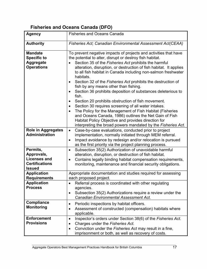
Fisheries and Oceans Canada (DFO) Agency
Fisheries and Oceans Canada
Authority
Fisheries Act; Canadian Environmental Assessment Act(CEAA)
Mandate Specific to Aggregate Operations
To prevent negative impacts of projects and activities that have the potential to alter, disrupt or destroy fish habitat. • Section 35 of the Fisheries Act prohibits the harmful
alteration, disruption, or destruction of fish habitat. It applies to all fish habitat in Canada including non-salmon freshwater habitats.
• Section 32 of the Fisheries Act prohibits the destruction of fish by any means other than fishing.
• Section 36 prohibits deposition of substances deleterious to fish.
• Section 20 prohibits obstruction of fish movement. • Section 30 requires screening of all water intakes. • The Policy for the Management of Fish Habitat (Fisheries
and Oceans Canada, 1986) outlines the Net Gain of Fish Habitat Policy Objective and provides direction for interpreting the broad powers mandated by the Fisheries Act.
Role in Aggregates Administration
• Case-by-case evaluations, conducted prior to project implementation, normally initiated through MEM referral.
• Impact avoidance by redesign and/or relocation is pursued as the first priority via the project planning process.
Permits, Approvals, Licenses and Certifications Issued
• Subsection 35(2) Authorization of unavoidable harmful alteration, disruption, or destruction of fish habitat.
• Contains legally binding habitat compensation requirements, monitoring, maintenance and financial security obligations.
Application Requirements
Appropriate documentation and studies required for assessing each proposed project.
Application Process
• Referral process is coordinated with other regulating agencies.
• Subsection 35(2) Authorizations require a review under the Canadian Environmental Assessment Act.
Compliance Monitoring
• Periodic inspections by habitat officers. • Assessment of constructed (compensation) habitats where
applicable. Enforcement Provisions
• Inspector’s orders under Section 38(6) of the Fisheries Act. • Charges under the Fisheries Act. • Conviction under the Fisheries Act may result in a fine,
imprisonment or both, as well as recovery of costs.

Aggregate Operators Best Management Practices Handbook for British Columbia
18
Contact Information
For General Enquiries, please contact: Director, Habitat and Enhancement Branch, Fisheries and Oceans Canada, 360-555 W Hastings St., Vancouver BC V6B 5G3, or the local DFO office. Website: http://www.pac.dfo-mpo.gc.ca
Additional
Fisheries and Oceans Canada includes the Canadian Coast Guard, which administers the Navigable Waters Protection Act. The provisions of this Act may regulate aspects of aggregate operations, including transport of aggregates.
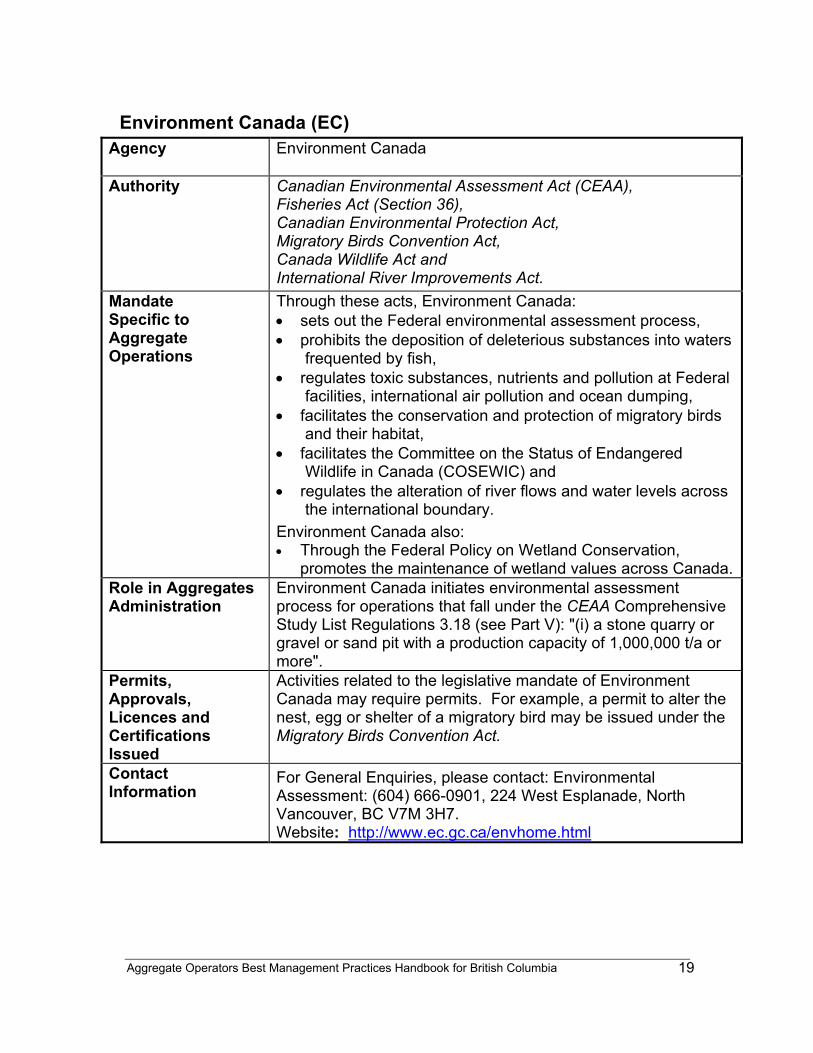
Aggregate Operators Best Management Practices Handbook for British Columbia
19
Environment Canada (EC) Agency
Environment Canada
Authority
Canadian Environmental Assessment Act (CEAA), Fisheries Act (Section 36), Canadian Environmental Protection Act, Migratory Birds Convention Act, Canada Wildlife Act and International River Improvements Act.
Mandate Specific to Aggregate Operations
Through these acts, Environment Canada: • sets out the Federal environmental assessment process, • prohibits the deposition of deleterious substances into waters
frequented by fish, • regulates toxic substances, nutrients and pollution at Federal
facilities, international air pollution and ocean dumping, • facilitates the conservation and protection of migratory birds
and their habitat, • facilitates the Committee on the Status of Endangered
Wildlife in Canada (COSEWIC) and • regulates the alteration of river flows and water levels across
the international boundary. Environment Canada also: • Through the Federal Policy on Wetland Conservation,
promotes the maintenance of wetland values across Canada.Role in Aggregates Administration
Environment Canada initiates environmental assessment process for operations that fall under the CEAA Comprehensive Study List Regulations 3.18 (see Part V): "(i) a stone quarry or gravel or sand pit with a production capacity of 1,000,000 t/a or more".
Permits, Approvals, Licences and Certifications Issued
Activities related to the legislative mandate of Environment Canada may require permits. For example, a permit to alter the nest, egg or shelter of a migratory bird may be issued under the Migratory Birds Convention Act.
Contact Information
For General Enquiries, please contact: Environmental Assessment: (604) 666-0901, 224 West Esplanade, North Vancouver, BC V7M 3H7. Website: http://www.ec.gc.ca/envhome.html
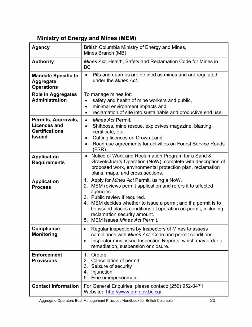
Aggregate Operators Best Management Practices Handbook for British Columbia
20
Ministry of Energy and Mines (MEM) Agency British Columbia Ministry of Energy and Mines,
Mines Branch (MB)
Authority Mines Act, Health, Safety and Reclamation Code for Mines in BC
Mandate Specific to Aggregate Operations
• Pits and quarries are defined as mines and are regulated under the Mines Act.
Role in Aggregates Administration
To manage mines for: • safety and health of mine workers and public, • minimal environment impacts and • reclamation of site into sustainable and productive end use.
Permits, Approvals, Licences and Certifications Issued
• Mines Act Permit. • Shiftboss, mine rescue, explosives magazine, blasting
certificate, etc. • Cutting licences on Crown Land. • Road use agreements for activities on Forest Service Roads
(FSR). Application Requirements
• Notice of Work and Reclamation Program for a Sand & Gravel/Quarry Operation (NoW), complete with description of proposed work, environmental protection plan, reclamation plans, maps, and cross sections.
Application Process
1. Apply for Mines Act Permit, using a NoW. 2. MEM reviews permit application and refers it to affected
agencies. 3. Public review if required. 4. MEM decides whether to issue a permit and if a permit is to
be issued places conditions of operation on permit, including reclamation security amount.
5. MEM issues Mines Act Permit.
Compliance Monitoring
• Regular inspections by Inspectors of Mines to assess compliance with Mines Act, Code and permit conditions.
• Inspector must issue Inspection Reports, which may order a remediation, suspension or closure.
Enforcement Provisions
1. Orders 2. Cancellation of permit 3. Seizure of security 4. Injunction 5. Fine or imprisonment
Contact Information For General Enquiries, please contact: (250) 952-0471 Website: http://www.em.gov.bc.ca/
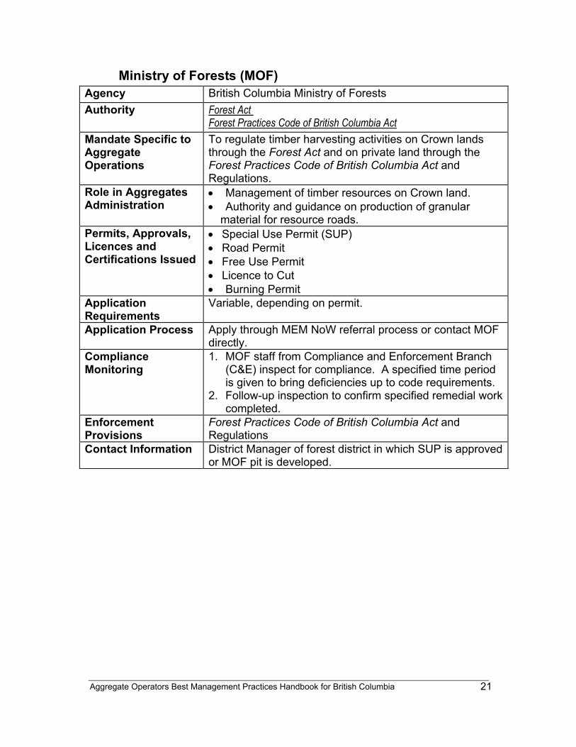
Aggregate Operators Best Management Practices Handbook for British Columbia
21
Ministry of Forests (MOF) Agency British Columbia Ministry of Forests Authority Forest Act
Forest Practices Code of British Columbia Act Mandate Specific to Aggregate Operations
To regulate timber harvesting activities on Crown lands through the Forest Act and on private land through the Forest Practices Code of British Columbia Act and Regulations.
Role in Aggregates Administration
• Management of timber resources on Crown land. • Authority and guidance on production of granular
material for resource roads. Permits, Approvals, Licences and Certifications Issued
• Special Use Permit (SUP) • Road Permit • Free Use Permit • Licence to Cut • Burning Permit
Application Requirements
Variable, depending on permit.
Application Process Apply through MEM NoW referral process or contact MOF directly.
Compliance Monitoring
1. MOF staff from Compliance and Enforcement Branch (C&E) inspect for compliance. A specified time period is given to bring deficiencies up to code requirements.
2. Follow-up inspection to confirm specified remedial work completed.
Enforcement Provisions
Forest Practices Code of British Columbia Act and Regulations
Contact Information District Manager of forest district in which SUP is approved or MOF pit is developed.
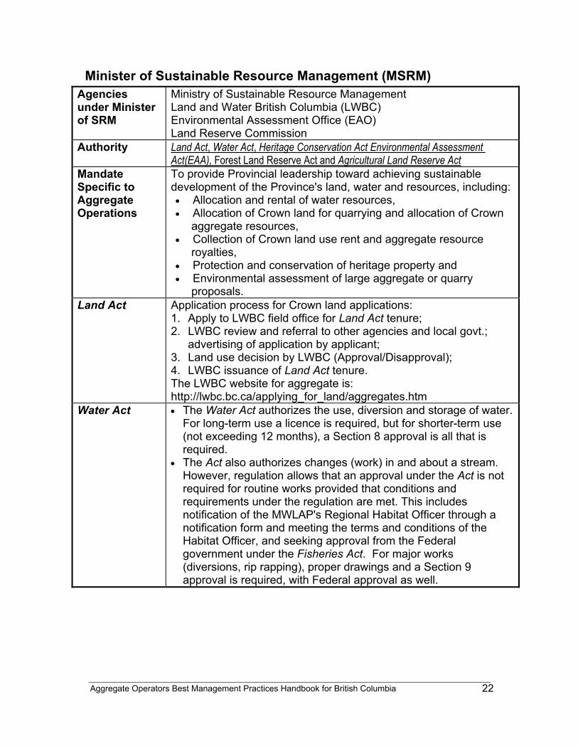
Aggregate Operators Best Management Practices Handbook for British Columbia
22
Minister of Sustainable Resource Management (MSRM) Agencies under Minister of SRM
Ministry of Sustainable Resource Management Land and Water British Columbia (LWBC) Environmental Assessment Office (EAO) Land Reserve Commission
Authority
Land Act, Water Act, Heritage Conservation Act Environmental Assessment Act(EAA), Forest Land Reserve Act and Agricultural Land Reserve Act
Mandate Specific to Aggregate Operations
To provide Provincial leadership toward achieving sustainable development of the Province's land, water and resources, including:
• Allocation and rental of water resources, • Allocation of Crown land for quarrying and allocation of Crown
aggregate resources, • Collection of Crown land use rent and aggregate resource
royalties, • Protection and conservation of heritage property and • Environmental assessment of large aggregate or quarry
proposals. Land Act Application process for Crown land applications:
1. Apply to LWBC field office for Land Act tenure; 2. LWBC review and referral to other agencies and local govt.;
advertising of application by applicant; 3. Land use decision by LWBC (Approval/Disapproval); 4. LWBC issuance of Land Act tenure. The LWBC website for aggregate is: http://lwbc.bc.ca/applying_for_land/aggregates.htm
Water Act • The Water Act authorizes the use, diversion and storage of water. For long-term use a licence is required, but for shorter-term use (not exceeding 12 months), a Section 8 approval is all that is required.
• The Act also authorizes changes (work) in and about a stream. However, regulation allows that an approval under the Act is not required for routine works provided that conditions and requirements under the regulation are met. This includes notification of the MWLAP's Regional Habitat Officer through a notification form and meeting the terms and conditions of the Habitat Officer, and seeking approval from the Federal government under the Fisheries Act. For major works (diversions, rip rapping), proper drawings and a Section 9 approval is required, with Federal approval as well.
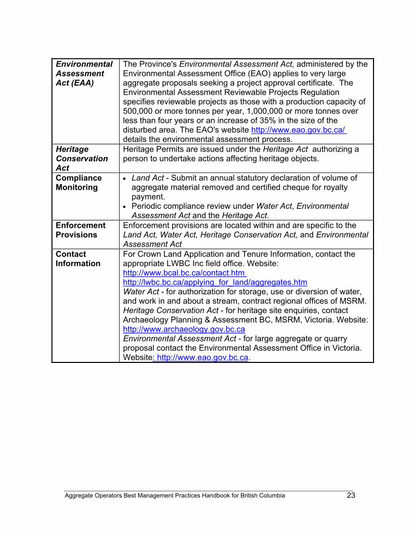
Aggregate Operators Best Management Practices Handbook for British Columbia
23
Environmental Assessment Act (EAA)
The Province's Environmental Assessment Act, administered by the Environmental Assessment Office (EAO) applies to very large aggregate proposals seeking a project approval certificate. The Environmental Assessment Reviewable Projects Regulation specifies reviewable projects as those with a production capacity of 500,000 or more tonnes per year, 1,000,000 or more tonnes over less than four years or an increase of 35% in the size of the disturbed area. The EAO's website http://www.eao.gov.bc.ca/ details the environmental assessment process.
Heritage Conservation Act
Heritage Permits are issued under the Heritage Act authorizing a person to undertake actions affecting heritage objects.
Compliance Monitoring
• Land Act - Submit an annual statutory declaration of volume of aggregate material removed and certified cheque for royalty payment.
• Periodic compliance review under Water Act, Environmental Assessment Act and the Heritage Act.
Enforcement Provisions
Enforcement provisions are located within and are specific to the Land Act, Water Act, Heritage Conservation Act, and Environmental Assessment Act
Contact Information
For Crown Land Application and Tenure Information, contact the appropriate LWBC Inc field office. Website: http://www.bcal.bc.ca/contact.htm http://lwbc.bc.ca/applying_for_land/aggregates.htm Water Act - for authorization for storage, use or diversion of water, and work in and about a stream, contract regional offices of MSRM. Heritage Conservation Act - for heritage site enquiries, contact Archaeology Planning & Assessment BC, MSRM, Victoria. Website: http://www.archaeology.gov.bc.ca Environmental Assessment Act - for large aggregate or quarry proposal contact the Environmental Assessment Office in Victoria. Website: http://www.eao.gov.bc.ca.
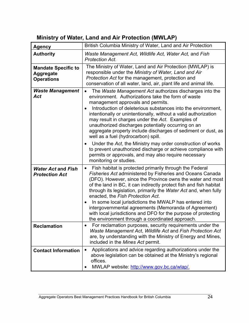
Aggregate Operators Best Management Practices Handbook for British Columbia
24
Ministry of Water, Land and Air Protection (MWLAP) Agency British Columbia Ministry of Water, Land and Air Protection
Authority Waste Management Act, Wildlife Act, Water Act, and Fish Protection Act.
Mandate Specific to Aggregate Operations
The Ministry of Water, Land and Air Protection (MWLAP) is responsible under the Ministry of Water, Land and Air Protection Act for the management, protection and conservation of all water, land, air, plant life and animal life.
Waste Management Act
• The Waste Management Act authorizes discharges into the environment. Authorizations take the form of waste management approvals and permits.
• Introduction of deleterious substances into the environment, intentionally or unintentionally, without a valid authorization may result in charges under the Act. Examples of unauthorized discharges potentially occurring on an aggregate property include discharges of sediment or dust, as well as a fuel (hydrocarbon) spill.
• Under the Act, the Ministry may order construction of works to prevent unauthorized discharge or achieve compliance with permits or approvals, and may also require necessary monitoring or studies.
Water Act and Fish Protection Act
• Fish habitat is protected primarily through the Federal Fisheries Act administered by Fisheries and Oceans Canada (DFO). However, since the Province owns the water and most of the land in BC, it can indirectly protect fish and fish habitat through its legislation, primarily the Water Act and, when fully enacted, the Fish Protection Act.
• In some local jurisdictions the MWALP has entered into intergovernmental agreements (Memoranda of Agreement) with local jurisdictions and DFO for the purpose of protecting the environment through a coordinated approach.
Reclamation • For reclamation purposes, security requirements under the Waste Management Act, Wildlife Act and Fish Protection Act are, by understanding with the Ministry of Energy and Mines, included in the Mines Act permit.
Contact Information • Applications and advice regarding authorizations under the above legislation can be obtained at the Ministry’s regional offices.
• MWLAP website: http://www.gov.bc.ca/wlap/.
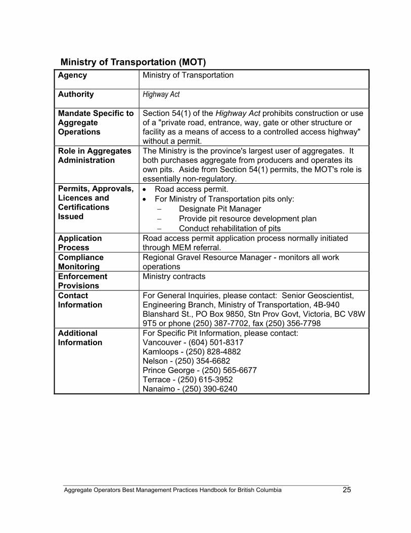
Aggregate Operators Best Management Practices Handbook for British Columbia
25
Ministry of Transportation (MOT) Agency
Ministry of Transportation
Authority
Highway Act
Mandate Specific to Aggregate Operations
Section 54(1) of the Highway Act prohibits construction or use of a "private road, entrance, way, gate or other structure or facility as a means of access to a controlled access highway" without a permit.
Role in Aggregates Administration
The Ministry is the province's largest user of aggregates. It both purchases aggregate from producers and operates its own pits. Aside from Section 54(1) permits, the MOT's role is essentially non-regulatory.
Permits, Approvals, Licences and Certifications Issued
• Road access permit. • For Ministry of Transportation pits only:
− Designate Pit Manager − Provide pit resource development plan − Conduct rehabilitation of pits
Application Process
Road access permit application process normally initiated through MEM referral.
Compliance Monitoring
Regional Gravel Resource Manager - monitors all work operations
Enforcement Provisions
Ministry contracts
Contact Information
For General Inquiries, please contact: Senior Geoscientist, Engineering Branch, Ministry of Transportation, 4B-940 Blanshard St., PO Box 9850, Stn Prov Govt, Victoria, BC V8W 9T5 or phone (250) 387-7702, fax (250) 356-7798
Additional Information
For Specific Pit Information, please contact: Vancouver - (604) 501-8317 Kamloops - (250) 828-4882 Nelson - (250) 354-6682 Prince George - (250) 565-6677 Terrace - (250) 615-3952 Nanaimo - (250) 390-6240
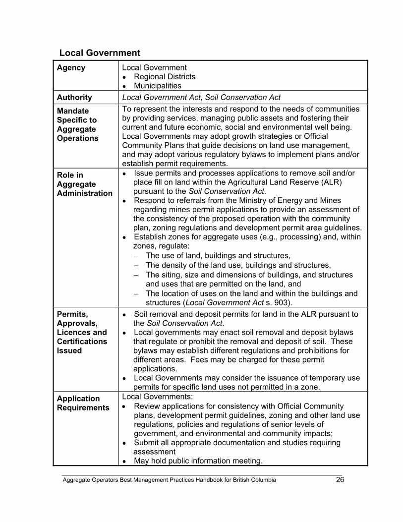
Aggregate Operators Best Management Practices Handbook for British Columbia
26
Local Government Agency Local Government
● Regional Districts ● Municipalities
Authority Local Government Act, Soil Conservation Act
Mandate Specific to Aggregate Operations
To represent the interests and respond to the needs of communities by providing services, managing public assets and fostering their current and future economic, social and environmental well being. Local Governments may adopt growth strategies or Official Community Plans that guide decisions on land use management, and may adopt various regulatory bylaws to implement plans and/or establish permit requirements.
Role in Aggregate Administration
● Issue permits and processes applications to remove soil and/or place fill on land within the Agricultural Land Reserve (ALR) pursuant to the Soil Conservation Act.
● Respond to referrals from the Ministry of Energy and Mines regarding mines permit applications to provide an assessment of the consistency of the proposed operation with the community plan, zoning regulations and development permit area guidelines.
● Establish zones for aggregate uses (e.g., processing) and, within zones, regulate: − The use of land, buildings and structures, − The density of the land use, buildings and structures, − The siting, size and dimensions of buildings, and structures
and uses that are permitted on the land, and − The location of uses on the land and within the buildings and
structures (Local Government Act s. 903). Permits, Approvals, Licences and Certifications Issued
● Soil removal and deposit permits for land in the ALR pursuant to the Soil Conservation Act.
● Local governments may enact soil removal and deposit bylaws that regulate or prohibit the removal and deposit of soil. These bylaws may establish different regulations and prohibitions for different areas. Fees may be charged for these permit applications.
● Local Governments may consider the issuance of temporary use permits for specific land uses not permitted in a zone.
Application Requirements
Local Governments: • Review applications for consistency with Official Community
plans, development permit guidelines, zoning and other land use regulations, policies and regulations of senior levels of government, and environmental and community impacts;
● Submit all appropriate documentation and studies requiring assessment
● May hold public information meeting.
Aggregate Operators Best Management Practices Handbook for British Columbia
27
Application Process
1. Within the ALR or Forest Land Reserve (FLR), apply to the Local Government.
2. Applications will be forwarded to the Land Reserve Commission (LRC) for a decision.
3. If approved by LRC, application is forwarded to Local Government for review and consideration of approval
4. Local Government issues permit. Compliance Monitoring
● Monitoring of local government regulations and permit compliance under Soil Conservation Act by Bylaw Enforcement Officer.
● Local Government answers public enquiries and refers issues or concerns to appropriate agencies as necessary.
Enforcement Provisions
● Enforcement of permits to remove soil and/or place fill on land in the ALR is subject to ticketing authority or court action, enforcement on non-ALR lands for activities contrary to local government regulations ultimately could result in court action.
Contact
Information
For general inquiries, contact: Local Governments listed in the government sections of telephone directories or on Civicnet @ http://www.civicnet.gov.bc.ca/.
Additional Information
Local Governments may have prepared independent land use studies or aggregate studies as part of the implementation of plans or bylaws. Official Community Plans often contain policies related to aggregate management and may show the location of known or active sand and gravel pits.
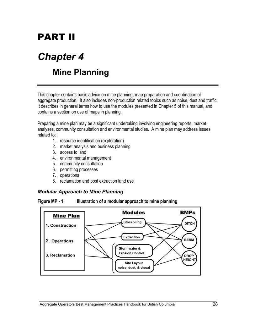
Aggregate Operators Best Management Practices Handbook for British Columbia
28
PART II Chapter 4
Mine Planning This chapter contains basic advice on mine planning, map preparation and coordination of aggregate production. It also includes non-production related topics such as noise, dust and traffic. It describes in general terms how to use the modules presented in Chapter 5 of this manual, and contains a section on use of maps in planning. Preparing a mine plan may be a significant undertaking involving engineering reports, market analyses, community consultation and environmental studies. A mine plan may address issues related to:
1. resource identification (exploration) 2. market analysis and business planning 3. access to land 4. environmental management 5. community consultation 6. permitting processes 7. operations 8. reclamation and post extraction land use
Modular Approach to Mine Planning
Figure MP - 1: Illustration of a modular approach to mine planning
Mine Plan
1. Construction 2. Operations 3. Reclamation
Modules BMPs
BERM
Site Layout noise, dust, & visual
Stormwater & Erosion Control
Extraction
Stockpiling
DROP HEIGHT
DITCH
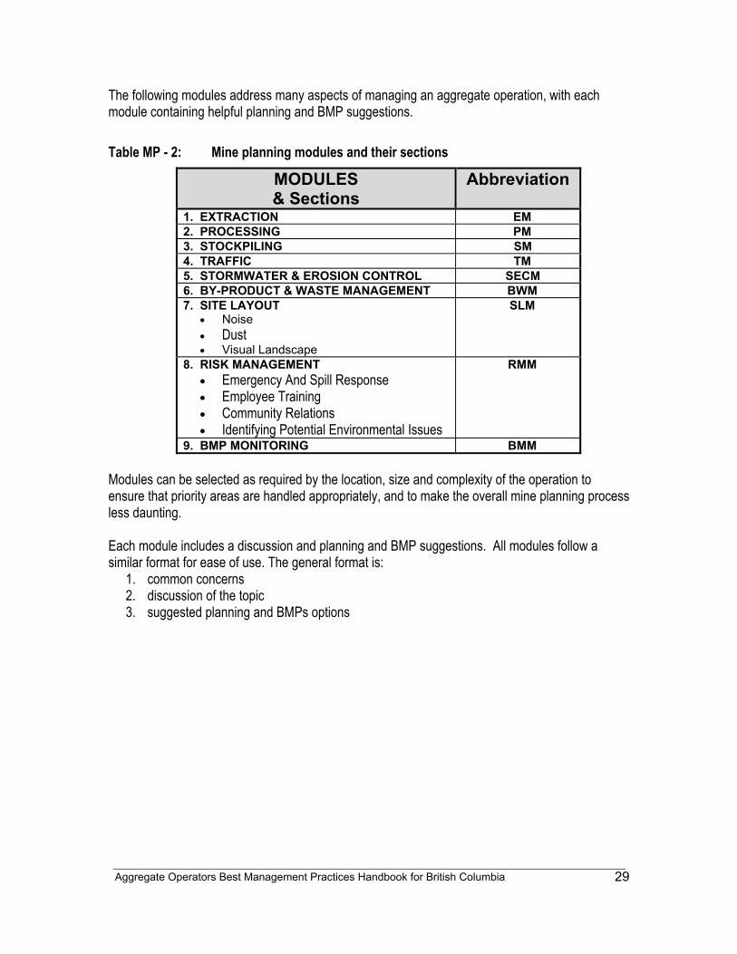
Aggregate Operators Best Management Practices Handbook for British Columbia
29
The following modules address many aspects of managing an aggregate operation, with each module containing helpful planning and BMP suggestions. Table MP - 2: Mine planning modules and their sections
MODULES & Sections
Abbreviation
1. EXTRACTION EM 2. PROCESSING PM 3. STOCKPILING SM 4. TRAFFIC TM 5. STORMWATER & EROSION CONTROL SECM 6. BY-PRODUCT & WASTE MANAGEMENT BWM 7. SITE LAYOUT
• Noise • Dust • Visual Landscape
SLM
8. RISK MANAGEMENT • Emergency And Spill Response • Employee Training • Community Relations • Identifying Potential Environmental Issues
RMM
9. BMP MONITORING BMM Modules can be selected as required by the location, size and complexity of the operation to ensure that priority areas are handled appropriately, and to make the overall mine planning process less daunting. Each module includes a discussion and planning and BMP suggestions. All modules follow a similar format for ease of use. The general format is:
1. common concerns 2. discussion of the topic 3. suggested planning and BMPs options
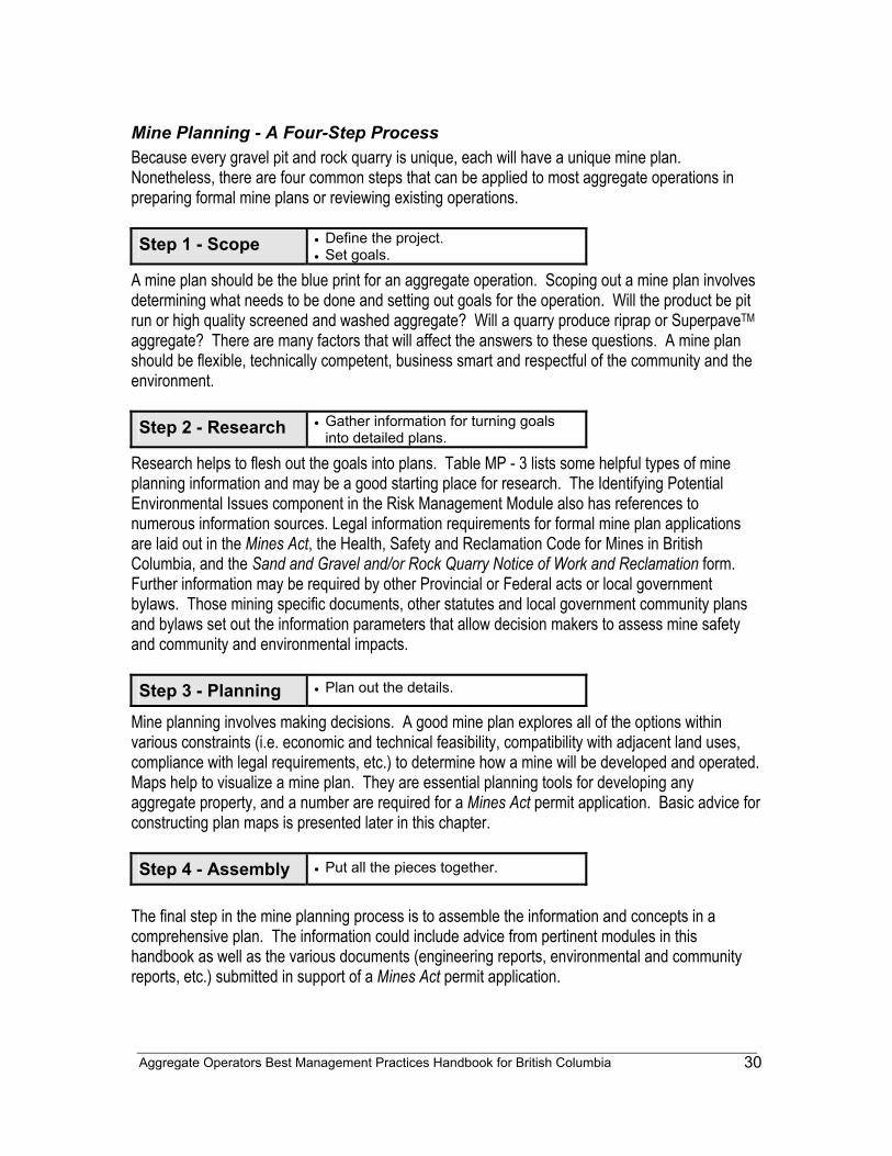
Aggregate Operators Best Management Practices Handbook for British Columbia
30
Mine Planning - A Four-Step Process Because every gravel pit and rock quarry is unique, each will have a unique mine plan. Nonetheless, there are four common steps that can be applied to most aggregate operations in preparing formal mine plans or reviewing existing operations. Step 1 - Scope • Define the project.
• Set goals.
A mine plan should be the blue print for an aggregate operation. Scoping out a mine plan involves determining what needs to be done and setting out goals for the operation. Will the product be pit run or high quality screened and washed aggregate? Will a quarry produce riprap or SuperpaveTM aggregate? There are many factors that will affect the answers to these questions. A mine plan should be flexible, technically competent, business smart and respectful of the community and the environment. Step 2 - Research • Gather information for turning goals
into detailed plans.
Research helps to flesh out the goals into plans. Table MP - 3 lists some helpful types of mine planning information and may be a good starting place for research. The Identifying Potential Environmental Issues component in the Risk Management Module also has references to numerous information sources. Legal information requirements for formal mine plan applications are laid out in the Mines Act, the Health, Safety and Reclamation Code for Mines in British Columbia, and the Sand and Gravel and/or Rock Quarry Notice of Work and Reclamation form. Further information may be required by other Provincial or Federal acts or local government bylaws. Those mining specific documents, other statutes and local government community plans and bylaws set out the information parameters that allow decision makers to assess mine safety and community and environmental impacts. Step 3 - Planning • Plan out the details.
Mine planning involves making decisions. A good mine plan explores all of the options within various constraints (i.e. economic and technical feasibility, compatibility with adjacent land uses, compliance with legal requirements, etc.) to determine how a mine will be developed and operated. Maps help to visualize a mine plan. They are essential planning tools for developing any aggregate property, and a number are required for a Mines Act permit application. Basic advice for constructing plan maps is presented later in this chapter. Step 4 - Assembly • Put all the pieces together.
The final step in the mine planning process is to assemble the information and concepts in a comprehensive plan. The information could include advice from pertinent modules in this handbook as well as the various documents (engineering reports, environmental and community reports, etc.) submitted in support of a Mines Act permit application.
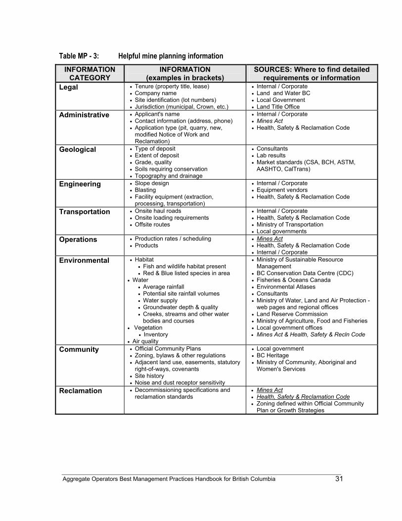
Aggregate Operators Best Management Practices Handbook for British Columbia
31
Table MP - 3: Helpful mine planning information INFORMATION
CATEGORY INFORMATION
(examples in brackets) SOURCES: Where to find detailed
requirements or information Legal • Tenure (property title, lease)
• Company name • Site identification (lot numbers) • Jurisdiction (municipal, Crown, etc.)
• Internal / Corporate • Land and Water BC • Local Government • Land Title Office
Administrative • Applicant's name • Contact information (address, phone) • Application type (pit, quarry, new,
modified Notice of Work and Reclamation)
• Internal / Corporate • Mines Act • Health, Safety & Reclamation Code
Geological
• Type of deposit • Extent of deposit • Grade, quality • Soils requiring conservation • Topography and drainage
• Consultants • Lab results • Market standards (CSA, BCH, ASTM,
AASHTO, CalTrans)
Engineering • Slope design • Blasting • Facility equipment (extraction,
processing, transportation)
• Internal / Corporate • Equipment vendors • Health, Safety & Reclamation Code
Transportation • Onsite haul roads • Onsite loading requirements • Offsite routes
• Internal / Corporate • Health, Safety & Reclamation Code • Ministry of Transportation • Local governments
Operations • Production rates / scheduling • Products
• Mines Act • Health, Safety & Reclamation Code • Internal / Corporate
Environmental • Habitat • Fish and wildlife habitat present • Red & Blue listed species in area
• Water • Average rainfall • Potential site rainfall volumes • Water supply • Groundwater depth & quality • Creeks, streams and other water
bodies and courses • Vegetation
• Inventory • Air quality
• Ministry of Sustainable Resource Management
• BC Conservation Data Centre (CDC) • Fisheries & Oceans Canada • Environmental Atlases • Consultants • Ministry of Water, Land and Air Protection -
web pages and regional offices • Land Reserve Commission • Ministry of Agriculture, Food and Fisheries • Local government offices • Mines Act & Health, Safety & Recln Code
Community • Official Community Plans
• Zoning, bylaws & other regulations • Adjacent land use, easements, statutory
right-of-ways, covenants • Site history • Noise and dust receptor sensitivity
• Local government • BC Heritage • Ministry of Community, Aboriginal and
Women's Services
Reclamation • Decommissioning specifications and reclamation standards
• Mines Act • Health, Safety & Reclamation Code • Zoning defined within Official Community
Plan or Growth Strategies
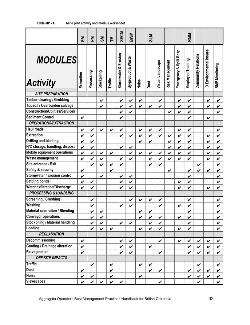
Aggregate Operators Best Management Practices Handbook for British Columbia
32
Table MP - 4: Mine plan activity and module worksheet
EM
PM
SM
TM
SECM
BWM
SLM
RMM
MODULES
Activity Extra
ctio
n
Proc
essin
g
Stoc
kpilin
g
Traf
fic
Stor
mwa
ter &
Ero
sion
By-p
rodu
ct &
Was
te
Noise
Dust
Visu
al La
ndsc
ape
Risk
Man
agem
ent
Emer
genc
y & S
pill R
esp.
Empl
oyee
Tra
inin
g
Com
mun
ity R
elatio
ns
ID E
nviro
nmen
tal Is
sues
BMP
Moni
torin
g
SITE PREPARATION Timber clearing / Grubbing ✔ ✔ ✔ ✔ ✔ ✔ ✔ ✔ ✔ Topsoil / Overburden salvage ✔ ✔ ✔ ✔ ✔ ✔ ✔ ✔ ✔ ✔ Construction/Utilities/Services ✔ ✔ ✔ ✔ ✔ ✔ Sediment Control ✔ ✔ ✔ ✔
OPERATIONS/EXTRACTION Haul roads ✔ ✔ ✔ ✔ ✔ ✔ ✔ ✔ ✔ ✔ ✔ Extraction ✔ ✔ ✔ ✔ ✔ ✔ ✔ ✔ ✔ ✔ ✔ ✔ Drilling and blasting ✔ ✔ ✔ ✔ ✔ ✔ ✔ ✔ ✔ H/C storage, handling, disposal ✔ ✔ ✔ ✔ ✔ ✔ ✔ ✔ ✔ Mobile equipment operations ✔ ✔ ✔ ✔ ✔ ✔ ✔ ✔ ✔ ✔ ✔ ✔ ✔ Waste management ✔ ✔ ✔ ✔ ✔ ✔ ✔ ✔ ✔ ✔ ✔ ✔ Site entrance / Exit ✔ ✔ ✔ ✔ ✔ ✔ ✔ ✔ Safety & security ✔ ✔ ✔ ✔ ✔ ✔ ✔ Stormwater / Erosion control ✔ ✔ ✔ ✔ ✔ ✔ Settling ponds ✔ ✔ ✔ ✔ ✔ ✔ ✔ Water exfiltration/Discharge ✔ ✔ ✔ ✔ ✔ ✔ ✔ ✔
PROCESSING & HANDLING Screening / Crushing ✔ ✔ ✔ ✔ ✔ ✔ ✔ Washing ✔ ✔ ✔ ✔ ✔ ✔ ✔ Material separation / Blending ✔ ✔ ✔ ✔ ✔ ✔ Conveyor operations ✔ ✔ ✔ ✔ ✔ ✔ ✔ ✔ Stockpiling / Material handling ✔ ✔ ✔ ✔ ✔ ✔ ✔ ✔ Loading ✔ ✔ ✔ ✔ ✔ ✔ ✔ ✔ ✔
RECLAMATION Decommissioning ✔ ✔ ✔ ✔ ✔ ✔ ✔ ✔ ✔ Grading / Drainage alteration ✔ ✔ ✔ ✔ ✔ ✔ ✔ ✔ Re-vegetation ✔ ✔ ✔ ✔ ✔ ✔ ✔ ✔
OFF SITE IMPACTS Traffic ✔ ✔ ✔ ✔ ✔ ✔ Dust ✔ ✔ ✔ ✔ ✔ ✔ ✔ ✔ Noise ✔ ✔ ✔ ✔ ✔ ✔ ✔ ✔ Viewscapes ✔ ✔ ✔ ✔ ✔ ✔ ✔ ✔
Aggregate Operators Best Management Practices Handbook for British Columbia
33
Maps - The Key Planning Tool Maps are the key tool for developing a mine plan. In order to clearly illustrate an operation, they should be of appropriate size and scale. Maps can range from pen and ink annotations on pre-printed government topographic maps, to digital products on customized and surveyed base maps. Basic information that is commonly required on maps is illustrated in Table MP - 5. Maps can be drawn to show almost any aspect of an aggregate operation and are specifically recommended in several of the modules in this handbook. The scale, complexity and location of an aggregate operation will determine how many, and what types of maps should be prepared. Depending upon the detail required, some maps may be combined. Table MP - 6 lists some common types of aggregate mine maps. The Ministry of Energy and Mines' Sand and Gravel / Quarry Notice of Work and Reclamation Program form outlines the Ministry's specific map requirements. Applications for other necessary permits or authorizations may also have specific map requirements.
Common Map Features Some common features that should be present on all aggregate permit application maps are:
• Boundaries of the requested permit area, • Elevations and contours, • Drainage patterns and names, • Jurisdictional boundaries and names of local governments, • Property boundaries, dimensions and lot numbers, • Roads, access points, railroads, utility lines, right-of-ways and easements with
complete names, • Current land uses including buildings and structures, locations of wells, park lands,
and other artificial features, • Boundaries and dimensions of the areas to be disturbed and mined, • Environmentally sensitive areas such as streams, lakes, wetlands, coastlines, coastal
bluffs, older forests, riparian vegetation and woodlands (Note: some local governments have Environmentally Sensitive Areas Atlases available to the public), and
• Adjacent land uses.
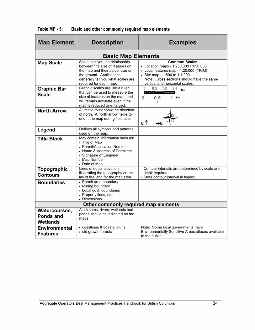
Aggregate Operators Best Management Practices Handbook for British Columbia
34
Table MP - 5: Basic and other commonly required map elements
Map Element Description Examples
Basic Map Elements Map Scale Scale tells you the relationship
between the size of features on the map and their actual size on the ground. Applications generally tell you what scales are required for each map.
Common Scales • Location maps - 1:250,000 / 1:50,000 • Local features map - 1:20,000 (TRIM) • Site map - 1:500 to 1:1,000
Note: Cross sections should have the same vertical and horizontal scales.
Graphic Bar Scale
Graphic scales are like a ruler that can be used to measure the size of features on the map, and will remain accurate even if the map is reduced or enlarged.
North Arrow All maps must show the direction of north. A north arrow helps to orient the map during field use.
N ↑ ➙ N Legend Defines all symbols and patterns
used on the map.
Title Block May contain information such as: • Title of Map • Permit/Application Number • Name & Address of Permittee • Signature of Engineer • Map Number • Date of Map
Topographic Contours
Lines of equal elevation, illustrating the topography or the lay of the land for the map area.
• Contour intervals are determined by scale and detail required.
• State contour interval in legend. Boundaries • Permit area boundary
• Mining boundary • Local govt. boundaries • Property lines, etc. • Dimensions
Other commonly required map elements Watercourses, Ponds and Wetlands
All streams, rivers, wetlands and ponds should be indicated on the maps.
Environmental Features
• coastlines & coastal bluffs • old growth forests
Note: Some local governments have Environmentally Sensitive Areas atlases available to the public.
Km
Km
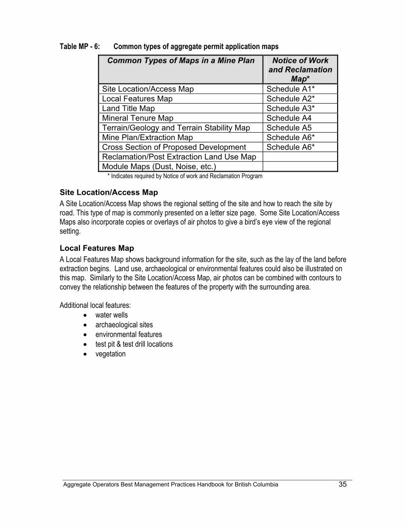
Aggregate Operators Best Management Practices Handbook for British Columbia
35
Table MP - 6: Common types of aggregate permit application maps Common Types of Maps in a Mine Plan Notice of Work
and Reclamation Map*
Site Location/Access Map Schedule A1* Local Features Map Schedule A2* Land Title Map Schedule A3* Mineral Tenure Map Schedule A4 Terrain/Geology and Terrain Stability Map Schedule A5 Mine Plan/Extraction Map Schedule A6* Cross Section of Proposed Development Schedule A6* Reclamation/Post Extraction Land Use Map Module Maps (Dust, Noise, etc.)
* Indicates required by Notice of work and Reclamation Program
Site Location/Access Map A Site Location/Access Map shows the regional setting of the site and how to reach the site by road. This type of map is commonly presented on a letter size page. Some Site Location/Access Maps also incorporate copies or overlays of air photos to give a bird’s eye view of the regional setting.
Local Features Map A Local Features Map shows background information for the site, such as the lay of the land before extraction begins. Land use, archaeological or environmental features could also be illustrated on this map. Similarly to the Site Location/Access Map, air photos can be combined with contours to convey the relationship between the features of the property with the surrounding area. Additional local features:
• water wells • archaeological sites • environmental features • test pit & test drill locations • vegetation
Aggregate Operators Best Management Practices Handbook for British Columbia
36
Mine Plan/Extraction Map Mine Plan/Extraction Maps show how the deposit will be mined. Applicants may choose to produce one for each phase of extraction or one for each stage of completion (e.g., at 25%, 50%, 75% and 100%). Alternatively, they may choose to illustrate all phases on a single map. Mine plan/extraction maps should be accompanied by cross sections showing water table information and, in the case of quarry plans, geological structure details. Additional Mine Plan/Extraction Map features:
• 2 metre contours • Permanent boundary markers • Proposed access roads • Setbacks and berms • BMPs (note codes in top left hand corner of BMPs for this use) • Stockpile areas • Primary crusher and processing plant • Stormwater and erosion control features (i.e., ditches, settling ponds, etc.)
Reclamation/Post-Extraction Land Use Map Sand and gravel pits and rock quarries in British Columbia may be reclaimed for agriculture, forestry, wildlife habitat, fish habitat, recreational, residential or industrial uses. Post-extraction land use may be determined by an official community plan (see Risk Management Module). An appropriate map should be prepared showing the configuration of the site upon completion of mining and reclamation. The key element of this map, which should include a cross section, is the proposed post-mining lay of the land, or grade. For ease of reference, the map should be of the same scale as the Local Features Map, or at a scale convenient for the post-extraction use of the site. For some situations, this map could also be the final mining stage or the 100% mine plan/extraction map. For reclamation details, refer to the Reclamation and Environmental Protection Handbook for Sand, Gravel and Quarry Operations in British Columbia. It is currently available from the Ministry of Transportation. Additional reclamation/post-extraction land use features:
• Reclaimed drainage patterns • Depth of replaced overburden, rock, and topsoil • Revegetation plans, if applicable
Aggregate Operators Best Management Practices Handbook for British Columbia
37
Chapter 5
Planning Modules page
5-1 EXTRACTION MODULE - EM................. 38
5-2 PROCESSING MODULE - PM ................ 46
5-3 STOCKPILING MODULE - SM ............... 51
5-4 TRAFFIC MODULE - TM ......................... 54 5-5 STORMWATER & EROSION CONTROL
MODULE - SECM .................................... 59
5-6 BY-PRODUCT & WASTE MODULE - BWM ...................................................... 65
5-7 SITE LAYOUT MODULE - SLM .............. 72
5-8 RISK MANAGEMENT MODULE - RMM . 90
5-9 BMP Monitoring Module - BMM ..........110
Aggregate Operators Best Management Practices Handbook for British Columbia
38
5 - 1 EXTRACTION MODULE - EM
Common Concerns: Extraction Extraction is a core activity for all aggregate operations. It is important that extraction be coordinated with processing in order to deliver material at an optimum size and rate from the working face into the processing stream (i.e., crushing or sizing facilities) or directly to the load-out facilities (Bowers et al. 1990). In additional, extraction should be coordinated with non-production considerations such as noise and dust reduction. Documentation of extraction planning in a formal extraction plan is also an application requirement for a Mines Act permit (Notice of Work & Reclamation for a Gravel Pit or Quarry) and may be required for local government soil removal permits. The location of the working face and the extraction technique used will affect an operation’s noise and dust emissions, visual impact and stormwater management, and may limit options for reclamation and post-extraction land uses. Adequate extraction planning may also help to avoid expensive and time-consuming problems once mine development proceeds. This module focuses on coordinating extraction activities with the non-production considerations of an operation (refer to Table EM - 2), and will offer only general technical advice. Advice for the technical components of extraction is readily available from publications such as The Aggregate Handbook of the National Stone, Sand and Gravel Association in the USA, and various trade journals and magazines.
Extraction Planning For extraction planning, aggregate operations may choose to have both long-term (mine-life) and short-term plans, and production related and non-production related plans as well.
Mine-Life Extraction Planning Mine-life extraction planning details the overall extraction scheme for the entire deposit, and major events in the life of the mine. It describes the mining strategy and coordinates production with other components and activities such as noise reduction and processing activities. Mine-life planning may also include major capital expenditures or equipment purchases.
Short-Term Extraction Planning Short-term extraction planning details expected activities over a one or two-year period. For example, phased extraction planning provides detail for one phase of a proposed operation. This type of planning can also specify operational direction on equipment selection, surface stripping areas, road developments and detailed extraction activities.
Production and Non-Production Related Planning Production and non-production related extraction planning is discussed in Tables EM-1 & EM-2. Following these tables are some key pointers for both production and non-production related considerations. Table EM-3 relates extraction components to other modules and BMPs in this handbook.
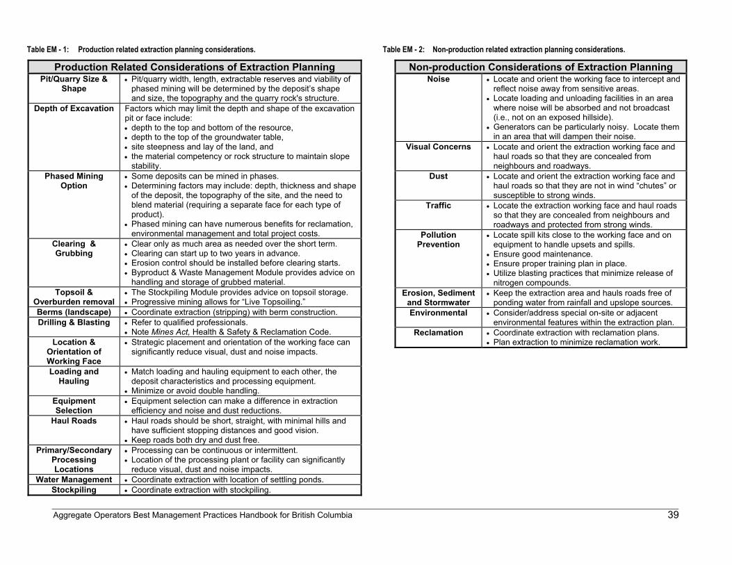
Aggregate Operators Best Management Practices Handbook for British Columbia
39
Table EM - 1: Production related extraction planning considerations.
Production Related Considerations of Extraction Planning Pit/Quarry Size &
Shape • Pit/quarry width, length, extractable reserves and viability of
phased mining will be determined by the deposit’s shape and size, the topography and the quarry rock's structure.
Depth of Excavation Factors which may limit the depth and shape of the excavation pit or face include: • depth to the top and bottom of the resource, • depth to the top of the groundwater table, • site steepness and lay of the land, and • the material competency or rock structure to maintain slope
stability. Phased Mining
Option • Some deposits can be mined in phases. • Determining factors may include: depth, thickness and shape
of the deposit, the topography of the site, and the need to blend material (requiring a separate face for each type of product).
• Phased mining can have numerous benefits for reclamation, environmental management and total project costs.
Clearing & Grubbing
• Clear only as much area as needed over the short term. • Clearing can start up to two years in advance. • Erosion control should be installed before clearing starts. • Byproduct & Waste Management Module provides advice on
handling and storage of grubbed material. Topsoil &
Overburden removal • The Stockpiling Module provides advice on topsoil storage. • Progressive mining allows for “Live Topsoiling.”
Berms (landscape) • Coordinate extraction (stripping) with berm construction. Drilling & Blasting • Refer to qualified professionals.
• Note Mines Act, Health & Safety & Reclamation Code. Location &
Orientation of Working Face
• Strategic placement and orientation of the working face can significantly reduce visual, dust and noise impacts.
Loading and Hauling
• Match loading and hauling equipment to each other, the deposit characteristics and processing equipment.
• Minimize or avoid double handling. Equipment Selection
• Equipment selection can make a difference in extraction efficiency and noise and dust reductions.
Haul Roads • Haul roads should be short, straight, with minimal hills and have sufficient stopping distances and good vision.
• Keep roads both dry and dust free. Primary/Secondary
Processing Locations
• Processing can be continuous or intermittent. • Location of the processing plant or facility can significantly
reduce visual, dust and noise impacts. Water Management • Coordinate extraction with location of settling ponds.
Stockpiling • Coordinate extraction with stockpiling.
Table EM - 2: Non-production related extraction planning considerations.
Non-production Considerations of Extraction Planning Noise • Locate and orient the working face to intercept and
reflect noise away from sensitive areas. • Locate loading and unloading facilities in an area
where noise will be absorbed and not broadcast (i.e., not on an exposed hillside).
• Generators can be particularly noisy. Locate them in an area that will dampen their noise.
Visual Concerns • Locate and orient the extraction working face and haul roads so that they are concealed from neighbours and roadways.
Dust • Locate and orient the extraction working face and haul roads so that they are not in wind “chutes” or susceptible to strong winds.
Traffic • Locate the extraction working face and haul roads so that they are concealed from neighbours and roadways and protected from strong winds.
Pollution Prevention
• Locate spill kits close to the working face and on equipment to handle upsets and spills.
• Ensure good maintenance. • Ensure proper training plan in place. • Utilize blasting practices that minimize release of
nitrogen compounds. Erosion, Sediment
and Stormwater • Keep the extraction area and hauls roads free of
ponding water from rainfall and upslope sources. Environmental • Consider/address special on-site or adjacent
environmental features within the extraction plan. Reclamation • Coordinate extraction with reclamation plans.
• Plan extraction to minimize reclamation work.
Aggregate Operators Best Management Practices Handbook for British Columbia
40
Extraction Planning: Key Pointers
Using Maps to Detail Extraction Plans Maps are the best tool to show the location of the extraction face, how extraction will proceed and, if possible, phases of progressive reclamation. Chapter 4 of this handbook, Mine Planning, has detailed advice on how to prepare maps for aggregate operations. That chapter refers to the maps (schedules) that should be included with a Notice of Work & Reclamation for a Gravel Pit or Quarry application. An "extraction plan map" is also commonly referred to by the name “mine development map.”
Matching Extraction Planning to Proven Reserves and Proposed Product Before selecting equipment to work the face and move the material, an operator should know the grade, competency and quantity of the sand and gravel, or the hardness, lithology and rock structure of the quarry material and, in either case, potential production rates and volumes. Sand and gravel deposits can be assessed using back hoe or excavator test pits, test holes drilled with a continuous flight auger or land form analysis (e.g., river terrace, delta, alluvial fan). For quarries, geological mapping, rock sampling and drilling can prove the extent of the extractable material. Operators should avoid areas with the potential for acid rock drainage, as discussed in Chapter 2. The proposed mining sequence and pit or quarry shape will be largely determined by both the deposit characteristics and the lay of the land. For uniform deposits on flat land, a wide range of extraction sequences could be used to maximize operational and non-technical goals. In tight situations where the deposit is deep and the quality of the aggregate varies considerably, options for extraction sequences and pit configurations may be severely limited.
Start-up Space Problem A sand and gravel pit or rock quarry requires a lot of space. Start-up can be one of the most difficult stages of an aggregate operation. During start-up, an operator must determine how much area should be cleared and grubbed, where top soil and overburden piles should be placed, where the extraction face should start, whether there is enough room for processing and when product can start to move, all in the shortest possible time frame. Other modules, such as stockpiling and processing, will help to solve these problems. Without proper planning, the temptation to simply place the overburden pile somewhere convenient "until we get going” may be irresistible, but the time required for moving the pile a second time ("double handling") will far outweigh the time saved initially. Adequate up-front extraction planning will help an operation start up more smoothly and quickly, while minimizing double handling of materials once the operation is running in full swing.
Visibility Where to begin the extraction face in order to minimize off-site impacts is an important decision. Commonly, an operator will start near the access point and work towards the back of the property.
Aggregate Operators Best Management Practices Handbook for British Columbia
41
This approach puts all activities where they are most visible right away, at a sensitive time for developing community relations. A number of operations have found that starting extraction in a less visible part of the property, and away from neighbours, allows the property itself to act as a buffer. In this way, mitigation tools such as treed berms will have been established to control dust and noise and act as visual screens before the operation approaches neighbouring properties. Also, a less visible operation is far more conducive to establishing good community relations at an early stage.
Working Top Down The conventional place to begin excavating a hillside gravel deposit is at the bottom of the slope. Consequently, the entire hillside may have to be exposed prior to reclamation and slopes may be cut too steeply, making them more prone to failure. Consider establishing the first excavation face at the top of a hillside and working down in benches or lifts. Reclamation can proceed on each bench as the next is opened up. In this way, the potential for slope failure is minimized Starting at the top also allows for more control of the orientation of the face. A properly orientated face may be less visible from local residences and highways, act as a barrier for noise and reduce wind exposure and dust generation.
Straight Short Haul-Roads The path between the working face and a primary processor (crusher) should be as short and straight as possible. Corners and hills require haul trucks to slow down, decreasing their operating efficiencies. If bends are required in the processing stream, then they should be at processing points. Grades should generally not exceed 10%, and road corridors should conform to the Health, Safety and Reclamation Code Section 6-8 specifications. Both access and haul roads are further discussed in the Traffic Module and the Haul Roads BMP.
Keeping It Dry Designing the extraction process to remain dry will benefit an operation in three ways. First, wet material is more difficult to process and requires drying once processed. Attempt to keep material dry until washing is required. Secondly, wet working areas increase wear and tear on tires and equipment. Wet tires are five times as susceptible as dry tires to slashing from sharp objects like rocks. Some wetting may be required for dust control. Thirdly, water collected from the excavation area requires treatment in settling ponds to remove sediment. Settling ponds require valuable space. If there is a risk of an oil or hydraulic fluid upset, runoff water may have to be treated in an oil/water separator. The extraction area can be kept dry by using diversion ditches, back-draining benches, and well-drained, crowned and elevated haul roads.
Aggregate Operators Best Management Practices Handbook for British Columbia
42
Clearing & Grubbing Clearing is the removal of trees and vegetation and grubbing is the removal of stumps and root systems. Local bylaws may regulate these activities. To cut down on dust, visibility and stormwater impacts, clearing and grubbing should be restricted to the areas that will be actively used for extraction, processing and stockpiling in the near future. If possible, these areas should be cleared and grubbed immediately prior to extraction. The Ministry of Forests (MOF) has a mandate to regulate timber harvesting on Crown land. Thus, the MOF should be notified well in advance of tree removal, so that any possible resource conflicts can be settled and an appropriate Licence to Cut or Free Use Permit obtained, in accordance with the Forest Act. Stumps and roots are normally burned or buried, subject to the Waste Management Act regulations. While chipping stumps is sometimes an option, it is generally prohibited by regulation because recent research has shown that stockpiled chips can leach acids. An alternative is to stockpile the stumps into berms or “beehives”. The stumps can be later spread over the site during reclamation, if forestry is planned, or used for erosion control. Stumps can provide habitat for birds, small animals and insects, and may enrich the soil when decayed (Buchanan, 1999).
Blasting Blasting can integrate extraction with processing by fragmenting rock into an optimal size for feed into the processing stream or for direct sale. In a blasting program, it is important to consider the structural discontinuities of the rock mass and the rock material strength. While blasting expertise will not be discussed in this handbook, the Health, Safety and Reclamation Code for Mines in British Columbia has very specific requirements regarding explosives. Mines Act certification is required for all blasters at pits and quarries. Fisheries and Oceans Canada has published guidelines for the use of explosives in or near Canadian fisheries waters (Wright and Hopky, 1998). Suppliers of explosives can provide technical advice and valuable information.
Extract to Reclamation Well-planned extraction can give reclamation a head start by reducing the amount of post-extraction work to be done. Final slope angles, shapes and grades can be established during extraction rather than as a separate operation (Norman et al., 1997), even if progressive reclamation is not an option. Where the shape of the deposit and lay of the land allow for phased extraction, progressive or segmented reclamation may be an option. Progressive reclamation can reduce topsoil and overburden handling, reduce the need for large stormwater management areas, prevent dust generation, reduce the amount of reclamation security required as a permit condition, and allow post-mining land uses to begin earlier.
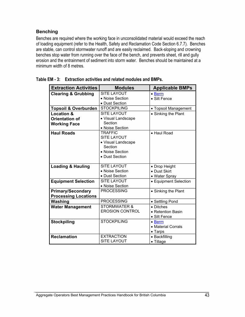
Aggregate Operators Best Management Practices Handbook for British Columbia
43
Benching Benches are required where the working face in unconsolidated material would exceed the reach of loading equipment (refer to the Health, Safety and Reclamation Code Section 6.7.7). Benches are stable, can control stormwater runoff and are easily reclaimed. Back-sloping and crowning benches stop water from running over the face of the bench, and prevents sheet, rill and gully erosion and the entrainment of sediment into storm water. Benches should be maintained at a minimum width of 8 metres. Table EM - 3: Extraction activities and related modules and BMPs. Extraction Activities Modules Applicable BMPs
Clearing & Grubbing SITE LAYOUT • Noise Section • Dust Section
• Berm • Silt Fence
Topsoil & Overburden STOCKPILING • Topsoil Management Location & Orientation of Working Face
SITE LAYOUT • Visual Landscape
Section • Noise Section
• Sinking the Plant
Haul Roads TRAFFIC SITE LAYOUT • Visual Landscape
Section • Noise Section • Dust Section
• Haul Road
Loading & Hauling SITE LAYOUT • Noise Section • Dust Section
• Drop Height • Dust Skirt • Water Spray
Equipment Selection SITE LAYOUT • Noise Section
• Equipment Selection
Primary/Secondary Processing Locations
PROCESSING • Sinking the Plant
Washing PROCESSING • Settling Pond Water Management STORMWATER &
EROSION CONTROL • Ditches • Retention Basin • Silt Fence
Stockpiling STOCKPILING • Berm • Material Corrals • Tarps
Reclamation EXTRACTION SITE LAYOUT
• Backfilling • Tillage
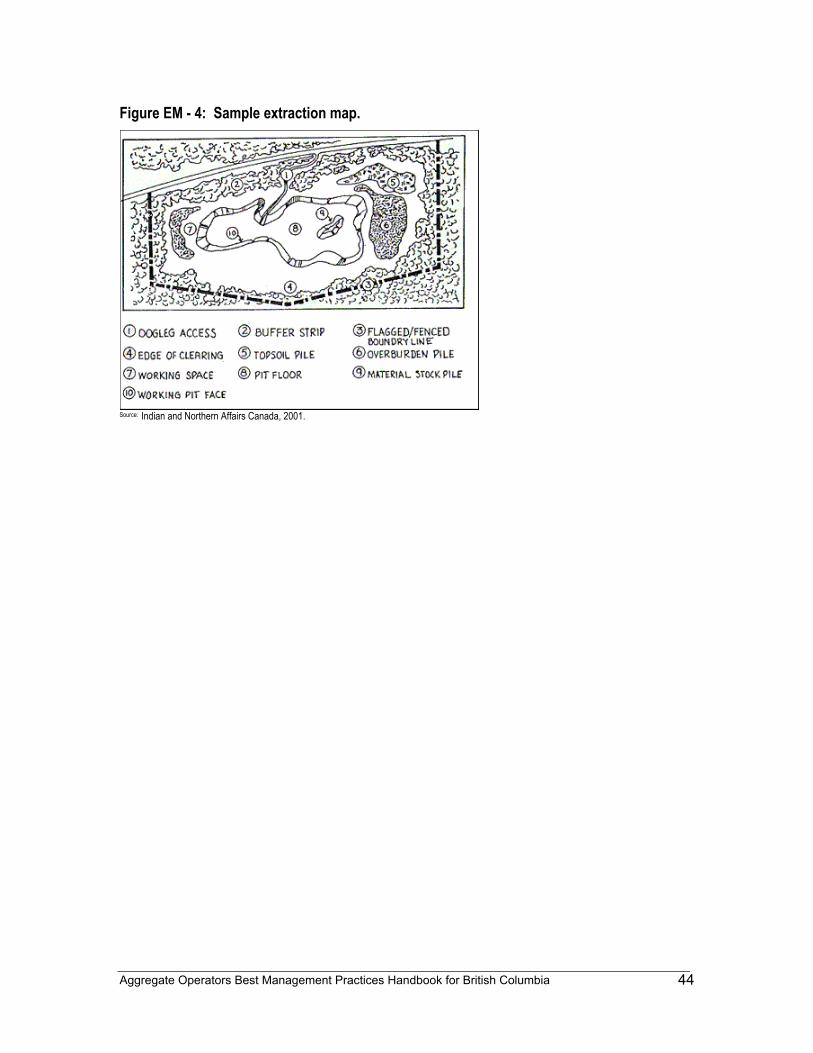
Aggregate Operators Best Management Practices Handbook for British Columbia
44
Figure EM - 4: Sample extraction map.
Source: Indian and Northern Affairs Canada, 2001.
Aggregate Operators Best Management Practices Handbook for British Columbia
45
5 - 2 PROCESSING MODULE - PM
Common Concerns: Aggregate Processing The processing plant at an aggregate operation may include crushers, screens, wash plants, generators and conveyors, and is often the focal point for heavy equipment activity at the site. As a result, aggregate processing may cause concerns relating to noise, dust and visual impacts. This module will discuss how and where to set up processing facilities to minimize land disturbance and community and environmental concerns. Process planning can identify changing plant needs, in order to coordinate improvements with the development of other site activities over the life of a mine. To identify these needs, processing planning should consider:
• extraction planning, • stockpiling planning, • stormwater & erosion control planning, and • traffic planning.
Addressing Processing Plant Concerns Processing of aggregate material can use a lot of water and energy, and may create undesirable noise, dust and visual impacts, and by-products such as sediment-laden water and wash-water fines. Reducing or mitigating processing plant concerns can start with the design of the processing plant and with equipment selection and layout. Table PM-3 lists various types of processing equipment, potential concerns associated with them, notes, pointers, and BMPs that can be used to address concerns. Table PM-4 lists some potential concerns and offers suggestions and BMP selections for mitigation. Safety is an important factor in plant design. Individual equipment should have adequate guarding, conveyor rules should be established and followed, and operating protocols should be clearly established. Refer to the Health, Safety and Reclamation Code Section 6-8 for plant safety regulations.
Processing Plant Location The location of the processing plant should allow for the coordination of extraction, stockpiling, load-out facilities, available space and other strategies to contain noise, dust and visual impacts. As Tables PM-3 and PM-4 indicate, strategic location is a primary tool for mitigating processing plants, and sometimes-different factors must be balanced. For example, a high plant location will facilitate the directing and treating of stormwater, whereas low locations are advantageous when noise or dust may be a significant issue. Extraction planning will help determine if and where there will be in-pit crushing or whether a fixed primary crushing station will be used.
Aggregate Operators Best Management Practices Handbook for British Columbia
46
Plant Type Before starting to purchase equipment, an operator should determine what type of processing plant would provide the best balance between optimizing production and potential noise, dust and visual concerns. The basic types of plants are listed Table PM - 1. Table PM - 1: Basic types of processing plants.
Processing Plant Type
Description
1 Stationary Plant • buildings and infrastructures with concrete foundations
• long-term and large operation • large space requirements
2 Semi-fixed Plant • less than 10 year life expectancy • skid-mounted equipment and mobile
conveyor systems
3 Mobile Plant • used at different locations for in-pit processing during separate phases of the mine extraction plan
• can also be used for smaller operations • equipment is rubber-tired or skid mounted
4 Seasonal / Contract Plant
• contract processing facility • seasonal or intermittent • rubber tired or skid mounted equipment
After: Pit & Quarry Quarryology 101, Lesson 3 Plant Design / Components, Part 1, "Type of Plant".
The Processing Plant Flow Sheet The selection of specific equipment with individual production capacities should be based on the type and estimated volume of processing proposed for the operation. This selection can be assisted using a Processing Plant Flow Sheet, as illustrated in Figure PM - 2. The Flow Sheet illustrates the “planned” configuration of machines, conveyors and chutes, and shows estimates of the tonnes-per-hour flow of each component. When putting together a Processing Plant Flow Sheet, an operator can begin to solve some of the following problems:
• What is the best plant type? (stationary, semi-fixed, mobile, or seasonal) • What are the crusher requirements? (crusher required? contract required? size, type,
power requirements, etc.) • Should wet or dry processing be used? • What types of screening will be required? (fractionation needs, screen types, volume,
numbers of screens, sizes, etc.) • Will sand screws be used? • What are the washing requirements? • How will surge piles be used? (where, how deposited, how big, reclaim
equipment,etc.)
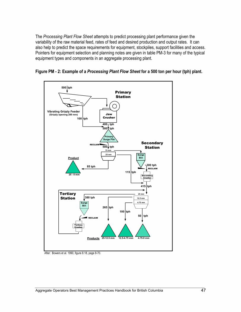
Aggregate Operators Best Management Practices Handbook for British Columbia
47
The Processing Plant Flow Sheet attempts to predict processing plant performance given the variability of the raw material feed, rates of feed and desired production and output rates. It can also help to predict the space requirements for equipment, stockpiles, support facilities and access. Pointers for equipment selection and planning notes are given in table PM-3 for many of the typical equipment types and components in an aggregate processing plant. Figure PM - 2: Example of a Processing Plant Flow Sheet for a 500 ton per hour (tph) plant.
500 tph
Vibrating Grizzly Feeder(Grizzly opening 200 mm)
500 tph400 tph
100 tph
500 tph
Primary Station
Primary Surge Pile
RECLAIM
RECLAIM
RECLAIM
75 mm
25 mm
25 mm
Product
85 tph 300 tph
115 tph
Tertiary Station
Secondary Station
12.5 mm
4.75 mm
415 tph
50 tph
265 tph100 tph
380 tph
Products 25-12.5 mm 4.75-0 mm12.5-4.75 mm
Surge Bin
Surge Bin
Jaw Crusher
Secondary Crusher
Tertiary Crusher
25 - 0 mm
After: Bowers et al. 1990, figure 8.18, page 8-70.
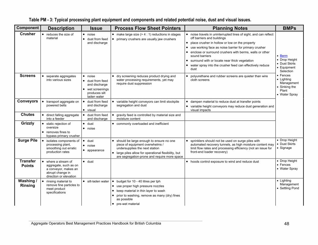
Aggregate Operators Best Management Practices Handbook for British Columbia
48
Table PM - 3: Typical processing plant equipment and components and related potential noise, dust and visual issues. Component Description Issue Process Flow Sheet Pointers Planning Notes BMPs
Crusher • reduces the size of material
• noise • dust from feed
and discharge
• make large size (> 4 : 1) reductions in stages • primary crushers are usually jaw crushers
• noise travels in uninterrupted lines of sight, and can reflect off barriers and buildings
• place crusher in hollow or low on the property • use working face as noise barrier for primary crusher • enclose or surround crushers with berms, walls or other
sound barriers • surround with or locate near thick vegetation • water spray into the crusher feed can effectively reduce
dust
• Berm • Drop Height • Dust Skirts • Equipment
Selection Screens • separate aggregates
into various sizes • noise • dust from feed
and discharge • wet screenings
produces silt laden water
• dry screening reduces product drying and water processing requirements, yet may require dust suppression
• polyurethane and rubber screens are quieter than wire cloth screens
• Fences • Lighting
Management • Sinking the
Plant • Water Spray
Conveyors • transport aggregate on powered belts
• dust from feed and discharge
• visual
• variable height conveyors can limit stockpile segregation and dust
• dampen material to reduce dust at transfer points • variable height conveyors may reduce dust generation and
visual impacts
Chutes • direct falling aggregate into a feeder
• dust from feed and discharge
• gravity feed is controlled by material size and moisture content
Grizzly • static rejection of oversize
• removes fines to bypass primary crusher
• dust • noise
• commonly overloaded and inefficient
Surge Pile • isolates components of processing plant, smoothing out erratic production rates
• dust • noise • appearance
• should be large enough to ensure no one piece of equipment overwhelms / undersupplies the next station
• large piles allow for operational flexibility, but are segregation-prone and require more space
• sprinklers should not be used on surge piles with automated recovery tunnels, as high moisture content may limit flow rates and processing efficiency (not an issue for front-end loader recovery)
• Drop Height • Dust Skirts • Signage
Transfer Points
• where a stream of aggregate, such as on a conveyor, makes an abrupt change in direction or elevation
• dust • hoods control exposure to wind and reduce dust • Drop Height • Fences • Water Spray
Washing / Rinsing
• rinsing material to remove fine particles to meet product specifications
• silt-laden water • budget for 10 - 40 litres per tph • use proper high pressure nozzles • keep material in thin layer to wash • prior to washing, remove as many (dry) fines
as possible • pre-wet material
• Lighting Management
• Settling Pond
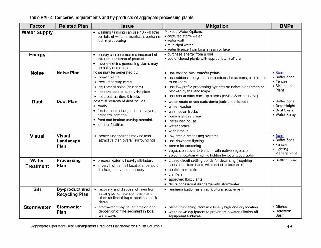
Aggregate Operators Best Management Practices Handbook for British Columbia
49
Table PM - 4: Concerns, requirements and by-products of aggregate processing plants. Factor Related Plan Issue Mitigation BMPs
Water Supply • washing / rinsing can use 10 - 40 litres per tph, of which a significant portion is lost in processing
Makeup Water Options: • captured storm water • water well • municipal water • water licence from local stream or lake
Energy • energy can be a major component of the cost per tonne of product
• mobile electric generating plants may be noisy and dusty
• purchase energy from a grid • use enclosed plants with appropriate mufflers
Noise Noise Plan noise may be generated by: • power plants • rock impacting metal • equipment noise (crushers) • loaders used to supply the plant • load out facilities & trucks
• use rock on rock transfer points • use rubber or polyurethane products for screens, chutes and
truck liners • use low profile processing systems so noise is absorbed or
blocked by the landscape • use non-audible back-up alarms (HSRC Section 12.31)
• Berm • Buffer Zone • Fences • Sinking the
Plant
Dust Dust Plan potential sources of dust include: • roads • feeds and discharges for conveyors,
crushers, screens • front end loaders moving material, • loadout facilities
• water roads or use surfactants (calcium chloride) • wheel washer • wash down trucks • pave high use areas • install bag house • water sprays • wind breaks
• Buffer Zone • Drop Height • Dust Skirts • Water Spray
Visual Visual Landscape Plan
• processing facilities may be less attractive than overall surroundings
• low profile processing systems • use downcast lighting • berms for screening • vegetation cover to blend in with native vegetation • select a location which is hidden by local topography
• Berm • Buffer Zone • Fences • Lighting
Management
Water Treatment
Processing Plan
• process water is heavily silt-laden, • in very high rainfall locations, periodic
discharge may be necessary
• closed circuit settling ponds for decanting (requiring substantial land base, with periodic clean outs)
• containment cells • clarifiers • approved flocculants • dilute occasional discharge with stormwater
• Settling Pond
Silt By-product and Recycling Plan
• recovery and disposal of fines from settling pond, retention basin and other sediment traps such as check dams
• remineralization as an agricultural supplement
Stormwater Stormwater Plan
• stormwater may cause erosion and deposition of fine sediment in local waterways
• place processing plant in a locally high and dry location • wash down equipment to prevent rain water siltation off
equipment surfaces
• Ditches • Retention
Basin
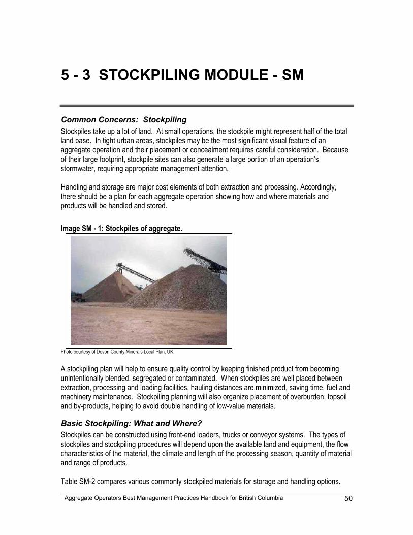
Aggregate Operators Best Management Practices Handbook for British Columbia
50
5 - 3 STOCKPILING MODULE - SM
Common Concerns: Stockpiling Stockpiles take up a lot of land. At small operations, the stockpile might represent half of the total land base. In tight urban areas, stockpiles may be the most significant visual feature of an aggregate operation and their placement or concealment requires careful consideration. Because of their large footprint, stockpile sites can also generate a large portion of an operation’s stormwater, requiring appropriate management attention. Handling and storage are major cost elements of both extraction and processing. Accordingly, there should be a plan for each aggregate operation showing how and where materials and products will be handled and stored. Image SM - 1: Stockpiles of aggregate. Photo courtesy of Devon County Minerals Local Plan, UK. A stockpiling plan will help to ensure quality control by keeping finished product from becoming unintentionally blended, segregated or contaminated. When stockpiles are well placed between extraction, processing and loading facilities, hauling distances are minimized, saving time, fuel and machinery maintenance. Stockpiling planning will also organize placement of overburden, topsoil and by-products, helping to avoid double handling of low-value materials.
Basic Stockpiling: What and Where? Stockpiles can be constructed using front-end loaders, trucks or conveyor systems. The types of stockpiles and stockpiling procedures will depend upon the available land and equipment, the flow characteristics of the material, the climate and length of the processing season, quantity of material and range of products. Table SM-2 compares various commonly stockpiled materials for storage and handling options.
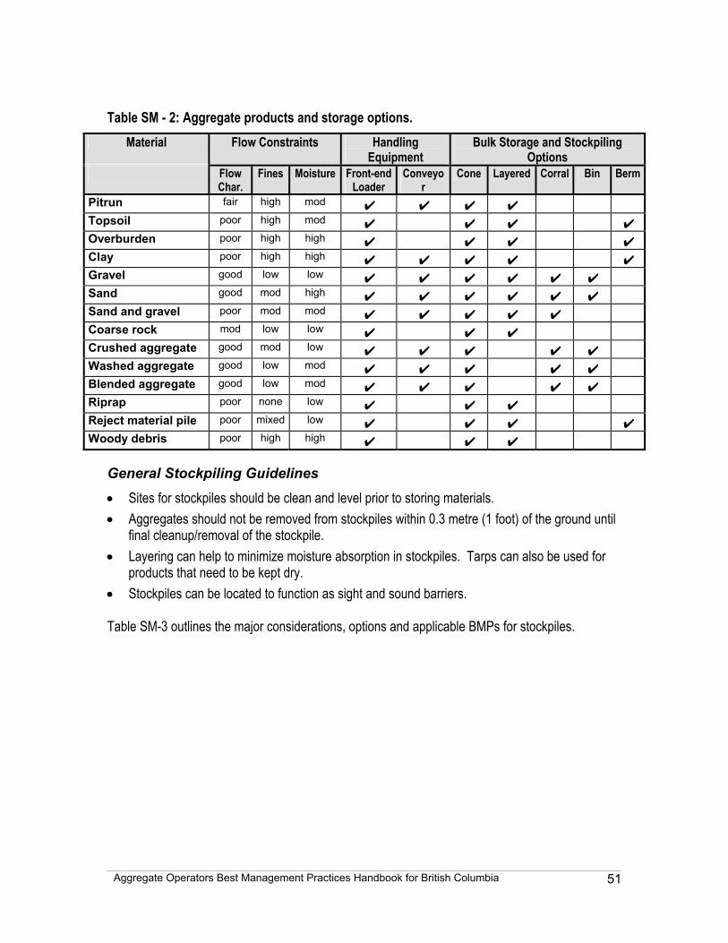
Aggregate Operators Best Management Practices Handbook for British Columbia
51
Table SM - 2: Aggregate products and storage options.
Material Flow Constraints Handling Equipment
Bulk Storage and Stockpiling Options
Flow Char.
Fines Moisture Front-end Loader
Conveyor
Cone Layered Corral Bin Berm
Pitrun fair high mod ✔ ✔ ✔ ✔ Topsoil poor high mod ✔ ✔ ✔ ✔ Overburden poor high high ✔ ✔ ✔ ✔ Clay poor high high ✔ ✔ ✔ ✔ ✔ Gravel good low low ✔ ✔ ✔ ✔ ✔ ✔ Sand good mod high ✔ ✔ ✔ ✔ ✔ ✔ Sand and gravel poor mod mod ✔ ✔ ✔ ✔ ✔ Coarse rock mod low low ✔ ✔ ✔ Crushed aggregate good mod low ✔ ✔ ✔ ✔ ✔ Washed aggregate good low mod ✔ ✔ ✔ ✔ ✔ Blended aggregate good low mod ✔ ✔ ✔ ✔ ✔ Riprap poor none low ✔ ✔ ✔ Reject material pile poor mixed low ✔ ✔ ✔ ✔ Woody debris poor high high ✔ ✔ ✔
General Stockpiling Guidelines
• Sites for stockpiles should be clean and level prior to storing materials. • Aggregates should not be removed from stockpiles within 0.3 metre (1 foot) of the ground until
final cleanup/removal of the stockpile. • Layering can help to minimize moisture absorption in stockpiles. Tarps can also be used for
products that need to be kept dry. • Stockpiles can be located to function as sight and sound barriers. Table SM-3 outlines the major considerations, options and applicable BMPs for stockpiles.
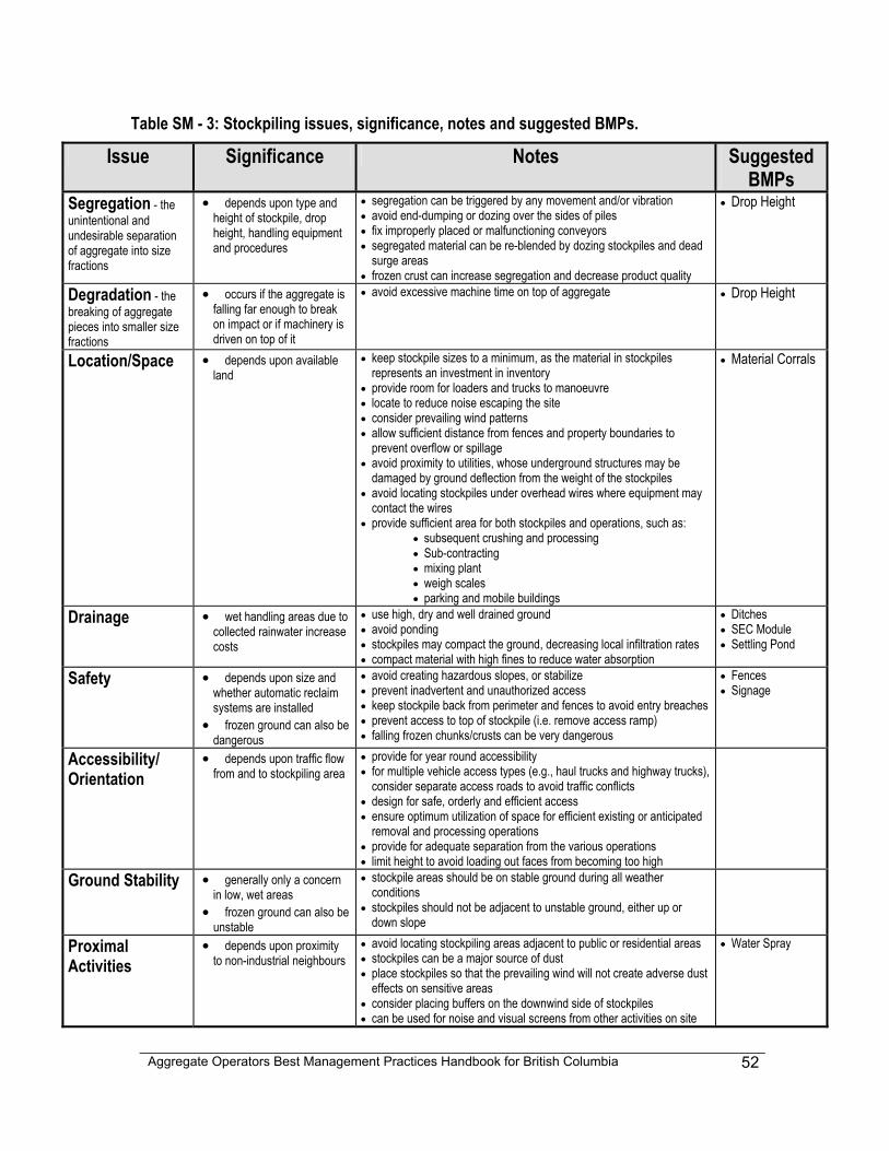
Aggregate Operators Best Management Practices Handbook for British Columbia
52
Table SM - 3: Stockpiling issues, significance, notes and suggested BMPs.
Issue Significance Notes Suggested BMPs
Segregation - the unintentional and undesirable separation of aggregate into size fractions
• depends upon type and height of stockpile, drop height, handling equipment and procedures
• segregation can be triggered by any movement and/or vibration • avoid end-dumping or dozing over the sides of piles • fix improperly placed or malfunctioning conveyors • segregated material can be re-blended by dozing stockpiles and dead
surge areas • frozen crust can increase segregation and decrease product quality
• Drop Height
Degradation - the breaking of aggregate pieces into smaller size fractions
• occurs if the aggregate is falling far enough to break on impact or if machinery is driven on top of it
• avoid excessive machine time on top of aggregate • Drop Height
Location/Space • depends upon available land
• keep stockpile sizes to a minimum, as the material in stockpiles represents an investment in inventory
• provide room for loaders and trucks to manoeuvre • locate to reduce noise escaping the site • consider prevailing wind patterns • allow sufficient distance from fences and property boundaries to
prevent overflow or spillage • avoid proximity to utilities, whose underground structures may be
damaged by ground deflection from the weight of the stockpiles • avoid locating stockpiles under overhead wires where equipment may
contact the wires • provide sufficient area for both stockpiles and operations, such as:
• subsequent crushing and processing • Sub-contracting • mixing plant • weigh scales • parking and mobile buildings
• Material Corrals
Drainage • wet handling areas due to collected rainwater increase costs
• use high, dry and well drained ground • avoid ponding • stockpiles may compact the ground, decreasing local infiltration rates • compact material with high fines to reduce water absorption
• Ditches • SEC Module • Settling Pond
Safety • depends upon size and whether automatic reclaim systems are installed
• frozen ground can also be dangerous
• avoid creating hazardous slopes, or stabilize • prevent inadvertent and unauthorized access • keep stockpile back from perimeter and fences to avoid entry breaches • prevent access to top of stockpile (i.e. remove access ramp) • falling frozen chunks/crusts can be very dangerous
• Fences • Signage
Accessibility/ Orientation
• depends upon traffic flow from and to stockpiling area
• provide for year round accessibility • for multiple vehicle access types (e.g., haul trucks and highway trucks),
consider separate access roads to avoid traffic conflicts • design for safe, orderly and efficient access • ensure optimum utilization of space for efficient existing or anticipated
removal and processing operations • provide for adequate separation from the various operations • limit height to avoid loading out faces from becoming too high
Ground Stability • generally only a concern in low, wet areas
• frozen ground can also be unstable
• stockpile areas should be on stable ground during all weather conditions
• stockpiles should not be adjacent to unstable ground, either up or down slope
Proximal Activities
• depends upon proximity to non-industrial neighbours
• avoid locating stockpiling areas adjacent to public or residential areas • stockpiles can be a major source of dust • place stockpiles so that the prevailing wind will not create adverse dust
effects on sensitive areas • consider placing buffers on the downwind side of stockpiles • can be used for noise and visual screens from other activities on site
• Water Spray
Aggregate Operators Best Management Practices Handbook for British Columbia
53
5 - 4 TRAFFIC MODULE - TM
Common Concerns: Aggregate Truck Traffic Transport can be the single largest cost factor per tonne for aggregates, for both on-site hauling and off-site delivery. Haul truck operations, safety and efficiency are crucial in keeping costs per tonne down. Residents and local governments commonly cite off-site traffic as a major concern regarding aggregate operations. Dump trucks can be noisy and dirty and their size can be intimidating. Their slow acceleration may add to congestion and, with frequent use, their weight can cause road deterioration. Unless an operation has its own fleet of trucks to deliver aggregate to off-site customers, individual truck issues are the responsibility of the trucking companies and managing local traffic is the responsibility of the local community. Nonetheless, producers can develop company traffic protocols to help manage these issues and work in conjunction with trucking companies and local governments. While on-site and off-site traffic planning can be combined in some situations (e.g., where highway trucks are loaded at the working face to transport material directly off-site), for many larger operations the issues are sufficiently distinct that planning for them can be done separately. On-site traffic planning considers aspects of haul roads and industrial traffic, site entrance and exit design, weigh scale layout, and can help alleviate noise, dust and visual impact. On-site traffic is regulated by the Health, Safety and Reclamation Code for Mines in British Columbia. An on-site traffic plan may be a condition of the Mines Act permit. Operators are advised to consult with their local inspector of mines on the application of Code requirements for their individual operations. Where trucks access a provincial highway directly from an operation, a highway access permit may be required. Off-site traffic planning can scope out concerns and suggest measures to limit impacts. Local planners will often request estimates of volumes, times and destinations of truck traffic, but traffic is often unpredictable due to seasonal variations and market demands. Traffic planning can also recommend driver protocols and can highlight measures the aggregate producer can take to reduce the impact of off-site traffic.
On-Site Traffic
Noise, Dust and Visual Impact Considerations of On-Site Traffic On-site traffic may generate dust and noise and may detract from the landscape character of an operation. The dust, noise and visual landscape sections in the Site Layout Module in this handbook all make recommendations with respect to on-site traffic. Table TM-1 summarizes the BMPs for consideration for on-site traffic management planning.
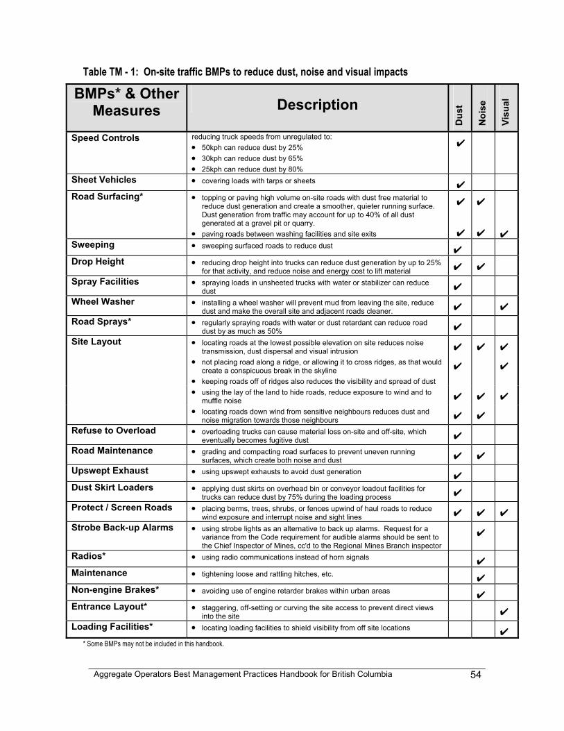
Aggregate Operators Best Management Practices Handbook for British Columbia
54
Table TM - 1: On-site traffic BMPs to reduce dust, noise and visual impacts
BMPs* & Other Measures Description
Dus
t
Noi
se
Visu
al
Speed Controls reducing truck speeds from unregulated to: • 50kph can reduce dust by 25% • 30kph can reduce dust by 65% • 25kph can reduce dust by 80%
✔
Sheet Vehicles • covering loads with tarps or sheets ✔ Road Surfacing* • topping or paving high volume on-site roads with dust free material to
reduce dust generation and create a smoother, quieter running surface. Dust generation from traffic may account for up to 40% of all dust generated at a gravel pit or quarry.
• paving roads between washing facilities and site exits
✔
✔
✔
✔
✔ Sweeping • sweeping surfaced roads to reduce dust ✔ Drop Height • reducing drop height into trucks can reduce dust generation by up to 25%
for that activity, and reduce noise and energy cost to lift material ✔ ✔ Spray Facilities • spraying loads in unsheeted trucks with water or stabilizer can reduce
dust ✔ Wheel Washer • installing a wheel washer will prevent mud from leaving the site, reduce
dust and make the overall site and adjacent roads cleaner. ✔ ✔ Road Sprays* • regularly spraying roads with water or dust retardant can reduce road
dust by as much as 50% ✔ Site Layout • locating roads at the lowest possible elevation on site reduces noise
transmission, dust dispersal and visual intrusion ✔ ✔ ✔ • not placing road along a ridge, or allowing it to cross ridges, as that would
create a conspicuous break in the skyline • keeping roads off of ridges also reduces the visibility and spread of dust
✔ ✔
• using the lay of the land to hide roads, reduce exposure to wind and to muffle noise ✔ ✔ ✔
• locating roads down wind from sensitive neighbours reduces dust and noise migration towards those neighbours ✔ ✔
Refuse to Overload • overloading trucks can cause material loss on-site and off-site, which eventually becomes fugitive dust ✔
Road Maintenance • grading and compacting road surfaces to prevent uneven running surfaces, which create both noise and dust ✔ ✔
Upswept Exhaust • using upswept exhausts to avoid dust generation ✔ Dust Skirt Loaders • applying dust skirts on overhead bin or conveyor loadout facilities for
trucks can reduce dust by 75% during the loading process ✔ Protect / Screen Roads • placing berms, trees, shrubs, or fences upwind of haul roads to reduce
wind exposure and interrupt noise and sight lines ✔ ✔ ✔ Strobe Back-up Alarms • using strobe lights as an alternative to back up alarms. Request for a
variance from the Code requirement for audible alarms should be sent to the Chief Inspector of Mines, cc'd to the Regional Mines Branch inspector
✔
Radios* • using radio communications instead of horn signals ✔ Maintenance • tightening loose and rattling hitches, etc. ✔ Non-engine Brakes* • avoiding use of engine retarder brakes within urban areas ✔ Entrance Layout* • staggering, off-setting or curving the site access to prevent direct views
into the site ✔ Loading Facilities* • locating loading facilities to shield visibility from off site locations ✔
* Some BMPs may not be included in this handbook.
Aggregate Operators Best Management Practices Handbook for British Columbia
55
Managing On-Site Aggregate Traffic Managing on-site traffic largely involves initial organization of protocols and procedures. Initial set-up time and costs will likely be recouped through prevention of lost time and resources needed to deal with traffic concerns. An effective tool for managing on-site traffic is an on-site traffic map, which could be part of or based upon an extraction or mine development map.
Considerations for On-Site Traffic Planning: • location of mine roads • types and volumes of traffic (including personal transport) likely to use on-site roads • speed limits • noise, dust and visual impacts that may affect proximal features and facilities (e.g.
residences, schools, retirement homes, hospitals) • entrance and exit requirements, and whether access is to a highway under The
Highway Act or to a local road • a right-of-way hierarchy • entrance/exit, loading facilities and mine-road layout to avoid unnecessary noise, dust
and detracting views • traffic and personnel transport protocols and procedures • an on-site traffic map • runaway lanes or retardation barriers on steep grades • posting maps, routes, protocols and procedures at the entrance, office, garage,
parking lot, etc. • training on-site workers and preparing an “on-site traffic expectation handout” for
contractors entering site.
Off-Site Traffic Off-site traffic is a commonly cited concern about aggregate operations, both by residents and local governments. Table TM-2 identifies and discusses a number of these traffic concerns and suggests BMPs and other mitigation measures.
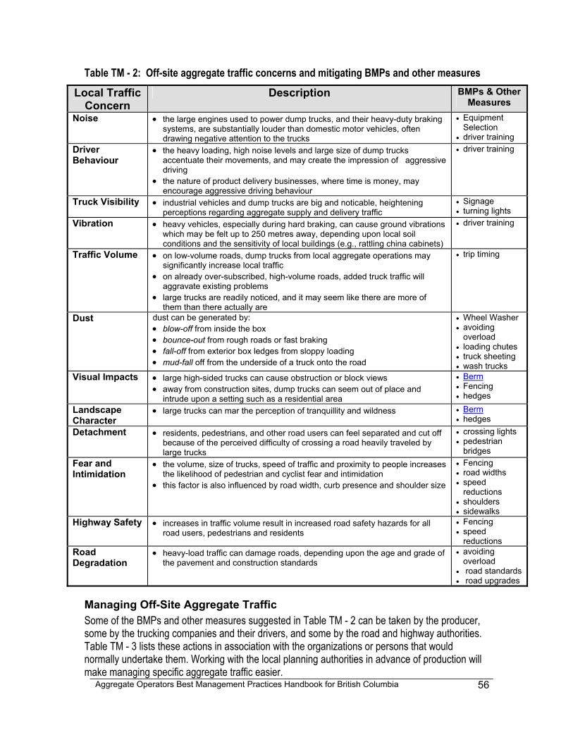
Aggregate Operators Best Management Practices Handbook for British Columbia
56
Table TM - 2: Off-site aggregate traffic concerns and mitigating BMPs and other measures Local Traffic
Concern Description BMPs & Other
Measures Noise • the large engines used to power dump trucks, and their heavy-duty braking
systems, are substantially louder than domestic motor vehicles, often drawing negative attention to the trucks
• Equipment Selection
• driver training Driver Behaviour
• the heavy loading, high noise levels and large size of dump trucks accentuate their movements, and may create the impression of aggressive driving
• the nature of product delivery businesses, where time is money, may encourage aggressive driving behaviour
• driver training
Truck Visibility • industrial vehicles and dump trucks are big and noticable, heightening perceptions regarding aggregate supply and delivery traffic
• Signage • turning lights
Vibration • heavy vehicles, especially during hard braking, can cause ground vibrations which may be felt up to 250 metres away, depending upon local soil conditions and the sensitivity of local buildings (e.g., rattling china cabinets)
• driver training
Traffic Volume • on low-volume roads, dump trucks from local aggregate operations may significantly increase local traffic
• on already over-subscribed, high-volume roads, added truck traffic will aggravate existing problems
• large trucks are readily noticed, and it may seem like there are more of them than there actually are
• trip timing
Dust dust can be generated by: • blow-off from inside the box • bounce-out from rough roads or fast braking • fall-off from exterior box ledges from sloppy loading • mud-fall off from the underside of a truck onto the road
• Wheel Washer • avoiding
overload • loading chutes • truck sheeting • wash trucks
Visual Impacts • large high-sided trucks can cause obstruction or block views • away from construction sites, dump trucks can seem out of place and
intrude upon a setting such as a residential area
• Berm • Fencing • hedges
Landscape Character
• large trucks can mar the perception of tranquillity and wildness • Berm • hedges
Detachment • residents, pedestrians, and other road users can feel separated and cut off because of the perceived difficulty of crossing a road heavily traveled by large trucks
• crossing lights • pedestrian
bridges Fear and Intimidation
• the volume, size of trucks, speed of traffic and proximity to people increases the likelihood of pedestrian and cyclist fear and intimidation
• this factor is also influenced by road width, curb presence and shoulder size
• Fencing • road widths • speed
reductions • shoulders • sidewalks
Highway Safety • increases in traffic volume result in increased road safety hazards for all road users, pedestrians and residents
• Fencing • speed
reductions Road Degradation
• heavy-load traffic can damage roads, depending upon the age and grade of the pavement and construction standards
• avoiding overload
• road standards • road upgrades
Managing Off-Site Aggregate Traffic Some of the BMPs and other measures suggested in Table TM - 2 can be taken by the producer, some by the trucking companies and their drivers, and some by the road and highway authorities. Table TM - 3 lists these actions in association with the organizations or persons that would normally undertake them. Working with the local planning authorities in advance of production will make managing specific aggregate traffic easier.
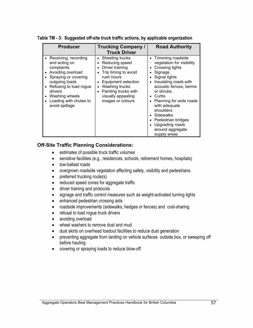
Aggregate Operators Best Management Practices Handbook for British Columbia
57
Table TM - 3: Suggested off-site truck traffic actions, by applicable organization
Producer Trucking Company / Truck Driver
Road Authority
• Receiving, recording and acting on complaints
• Avoiding overload • Spraying or covering
outgoing loads • Refusing to load rogue
drivers • Washing wheels • Loading with chutes to
avoid spillage
• Sheeting trucks • Reducing speed • Driver training • Trip timing to avoid
rush hours • Equipment selection • Washing trucks • Painting trucks with
visually appealing images or colours
• Trimming roadside vegetation for visibility
• Crossing lights • Signage • Signal lights • Insulating roads with
acoustic fences, berms or shrubs.
• Curbs • Planning for wide roads
with adequate shoulders
• Sidewalks • Pedestrian bridges • Upgrading roads
around aggregate supply areas
Off-Site Traffic Planning Considerations: • estimates of possible truck traffic volumes • sensitive facilities (e.g., residences, schools, retirement homes, hospitals) • low-ballast roads • overgrown roadside vegetation affecting safety, visibility and pedestrians. • preferred trucking route(s) • reduced speed zones for aggregate traffic • driver training and protocols • signage and traffic control measures such as weight-activated turning lights • enhanced pedestrian crossing aids • roadside improvements (sidewalks, hedges or fences) and cost-sharing • refusal to load rogue truck drivers • avoiding overload • wheel washers to remove dust and mud • dust skirts on overhead loadout facilities to reduce dust generation • preventing aggregate from landing on vehicle surfaces outside box, or sweeping off
before hauling. • covering or spraying loads to reduce blow-off.
Aggregate Operators Best Management Practices Handbook for British Columbia
58
5 - 5 STORMWATER & EROSION CONTROL MODULE - SECM
Common Concerns: Stormwater & Erosion Control Without adequate stormwater or erosion protection measures, exposed soils have the potential to introduce large amounts of sediments and silts to both natural and manmade environments. Proper control of stormwater and erosion at aggregate operations may decrease the need for pre-discharge treatment of stormwater and decrease the likelihood of off-site environmental impacts, such as degraded surface waters and fish habitat. A Mines Act permit application (Notice of Work & Reclamation for a Gravel Pit or Quarry) requests a description of surface run-off and sediment control measures (schedule B). If stormwater is discharged to the environment, a Waste Management Act permit may be required, and if diversion ditches or settling ponds are constructed, a Water Act authorization may be required. The geotechnical requirements of the Health, Safety & Reclamation Code for Mines in BC are designed to prevent landslides, slumps and debris flows caused by extreme stormwater and erosion from occurring at mine sites. This module will address the slower and less spectacular, yet potentially as damaging phenomena of unchecked erosion, transport and sedimentation of soils, silts and clays into surface waters and aquatic environments. Stormwater and erosion control planning can help limit topsoil and fine product loss due to erosion by wind or precipitation, and reduce the amount of siltation, fugitive dust and exposed soils. Effective stormwater and erosion control practices keep working sites dry, which cuts operating costs through reducing wear and tear on equipment and tires, and lessens the need for pre-discharge treatment of storm water. Stormwater planning can help to identify the stormwater management requirements of a site and the selection of BMPs for stormwater control. The scale of the stormwater planning should reflect the size and complexity of an aggregate operation. Stormwater planning can be as simple as stormwater BMPs sketched on a copy of the extraction map, or as comprehensive as a professional hydrological analysis. Erosion control planning can help identify the location and character of the erosion hazards and risks on an aggregate site and assist in the selection of control methods. For both stormwater and erosion control, the basic control BMPs are:
• Bioengineering • Buffer Zone • Ditches • Retention Basins • Settling Pond • Vegetation Cover
• benches • hydroseeding • swales • treed wind breaks • wetlands
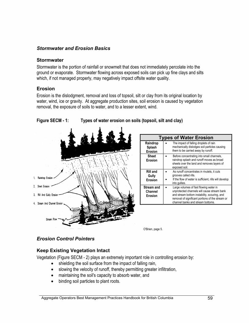
Aggregate Operators Best Management Practices Handbook for British Columbia
59
Stormwater and Erosion Basics
Stormwater Stormwater is the portion of rainfall or snowmelt that does not immediately percolate into the ground or evaporate. Stormwater flowing across exposed soils can pick up fine clays and silts which, if not managed properly, may negatively impact offsite water quality.
Erosion Erosion is the dislodgment, removal and loss of topsoil, silt or clay from its original location by water, wind, ice or gravity. At aggregate production sites, soil erosion is caused by vegetation removal, the exposure of soils to water, and to a lesser extent, wind. Figure SECM - 1: Types of water erosion on soils (topsoil, silt and clay)
O'Brien, page 5.
Erosion Control Pointers
Keep Existing Vegetation Intact Vegetation (Figure SECM - 2) plays an extremely important role in controlling erosion by:
• shielding the soil surface from the impact of falling rain, • slowing the velocity of runoff, thereby permitting greater infiltration, • maintaining the soil's capacity to absorb water, and • binding soil particles to plant roots.
Types of Water Erosion Raindrop Splash Erosion
• The impact of falling droplets of rain mechanically dislodges soil particles causing them to be carried away by runoff.
Sheet Erosion
• Before concentrating into small channels, raindrop splash and runoff moves as broad sheets over the land and removes layers of exposed soil.
Rill and Gully
Erosion
• As runoff concentrates in rivulets, it cuts grooves called rills.
• If the flow of water is sufficient, rills will develop into gullies.
Stream and Channel Erosion
• Large volumes of fast flowing water in unprotected channels will cause stream bank and stream bottom instability, scouring, and removal of significant portions of the stream or channel banks and stream bottoms.
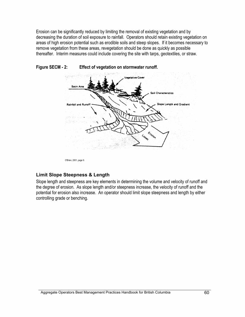
Aggregate Operators Best Management Practices Handbook for British Columbia
60
Erosion can be significantly reduced by limiting the removal of existing vegetation and by decreasing the duration of soil exposure to rainfall. Operators should retain existing vegetation on areas of high erosion potential such as erodible soils and steep slopes. If it becomes necessary to remove vegetation from these areas, revegetation should be done as quickly as possible thereafter. Interim measures could include covering the site with tarps, geotextiles, or straw. Figure SECM - 2: Effect of vegetation on stormwater runoff.
O'Brien, 2001, page 9.
Limit Slope Steepness & Length Slope length and steepness are key elements in determining the volume and velocity of runoff and the degree of erosion. As slope length and/or steepness increase, the velocity of runoff and the potential for erosion also increase. An operator should limit slope steepness and length by either controlling grade or benching.
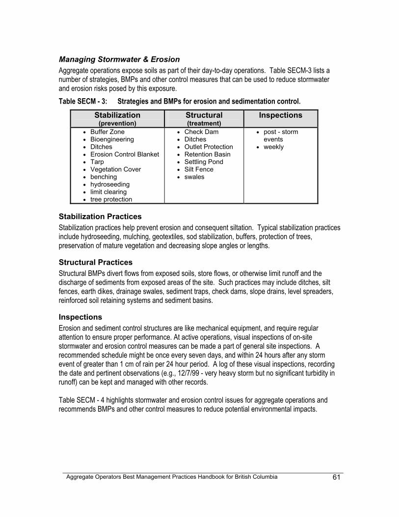
Aggregate Operators Best Management Practices Handbook for British Columbia
61
Managing Stormwater & Erosion Aggregate operations expose soils as part of their day-to-day operations. Table SECM-3 lists a number of strategies, BMPs and other control measures that can be used to reduce stormwater and erosion risks posed by this exposure. Table SECM - 3: Strategies and BMPs for erosion and sedimentation control.
Stabilization (prevention)
Structural (treatment)
Inspections
• Buffer Zone • Bioengineering • Ditches • Erosion Control Blanket • Tarp • Vegetation Cover • benching • hydroseeding • limit clearing • tree protection
• Check Dam • Ditches • Outlet Protection • Retention Basin • Settling Pond • Silt Fence • swales
• post - storm events
• weekly
Stabilization Practices Stabilization practices help prevent erosion and consequent siltation. Typical stabilization practices include hydroseeding, mulching, geotextiles, sod stabilization, buffers, protection of trees, preservation of mature vegetation and decreasing slope angles or lengths.
Structural Practices Structural BMPs divert flows from exposed soils, store flows, or otherwise limit runoff and the discharge of sediments from exposed areas of the site. Such practices may include ditches, silt fences, earth dikes, drainage swales, sediment traps, check dams, slope drains, level spreaders, reinforced soil retaining systems and sediment basins.
Inspections Erosion and sediment control structures are like mechanical equipment, and require regular attention to ensure proper performance. At active operations, visual inspections of on-site stormwater and erosion control measures can be made a part of general site inspections. A recommended schedule might be once every seven days, and within 24 hours after any storm event of greater than 1 cm of rain per 24 hour period. A log of these visual inspections, recording the date and pertinent observations (e.g., 12/7/99 - very heavy storm but no significant turbidity in runoff) can be kept and managed with other records. Table SECM - 4 highlights stormwater and erosion control issues for aggregate operations and recommends BMPs and other control measures to reduce potential environmental impacts.
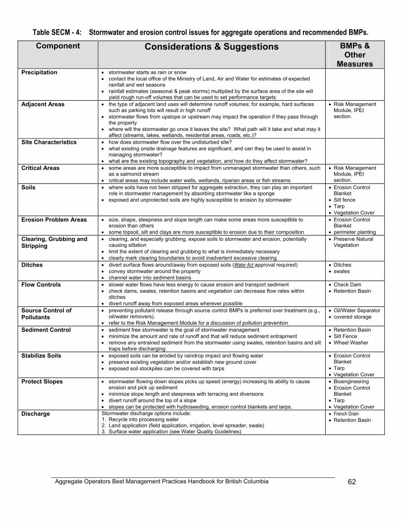
Aggregate Operators Best Management Practices Handbook for British Columbia
62
Table SECM - 4: Stormwater and erosion control issues for aggregate operations and recommended BMPs. Component Considerations & Suggestions BMPs &
Other Measures
Precipitation • stormwater starts as rain or snow • contact the local office of the Ministry of Land, Air and Water for estimates of expected
rainfall and wet seasons • rainfall estimates (seasonal & peak storms) multiplied by the surface area of the site will
yield rough run-off volumes that can be used to set performance targets
Adjacent Areas • the type of adjacent land uses will determine runoff volumes; for example, hard surfaces such as parking lots will result in high runoff
• stormwater flows from upslope or upstream may impact the operation if they pass through the property
• where will the stormwater go once it leaves the site? What path will it take and what may it affect (streams, lakes, wetlands, residential areas, roads, etc.)?
• Risk Management Module, IPEI section.
Site Characteristics • how does stormwater flow over the undisturbed site? • what existing onsite drainage features are significant, and can they be used to assist in
managing stormwater? • what are the existing topography and vegetation, and how do they affect stormwater?
Critical Areas • some areas are more susceptible to impact from unmanaged stormwater than others, such as a salmonid stream
• critical areas may include water wells, wetlands, riparian areas or fish streams
• Risk Management Module, IPEI section.
Soils • where soils have not been stripped for aggregate extraction, they can play an important role in stormwater management by absorbing stormwater like a sponge
• exposed and unprotected soils are highly susceptible to erosion by stormwater
• Erosion Control Blanket
• Silt fence • Tarp • Vegetation Cover
Erosion Problem Areas • size, shape, steepness and slope length can make some areas more susceptible to erosion than others
• some topsoil, silt and clays are more susceptible to erosion due to their composition
• Erosion Control Blanket
• perimeter planting Clearing, Grubbing and Stripping
• clearing, and especially grubbing, expose soils to stormwater and erosion, potentially causing siltation
• limit the extent of clearing and grubbing to what is immediately necessary • clearly mark clearing boundaries to avoid inadvertent excessive clearing
• Preserve Natural Vegetation
Ditches • divert surface flows around/away from exposed soils (Water Act approval required) • convey stormwater around the property • channel water into sediment basins
• Ditches • swales
Flow Controls • slower water flows have less energy to cause erosion and transport sediment • check dams, swales, retention basins and vegetation can decrease flow rates within
ditches • divert runoff away from exposed areas wherever possible
• Check Dam • Retention Basin
Source Control of Pollutants
• preventing pollutant release through source control BMPs is preferred over treatment (e.g., oil/water removers).
• refer to the Risk Management Module for a discussion of pollution prevention
• Oil/Water Separator • covered storage
Sediment Control • sediment free stormwater is the goal of stormwater management • minimize the amount and rate of runoff and that will reduce sediment entrapment • remove any entrained sediment from the stormwater using swales, retention basins and silt
traps before discharging
• Retention Basin • Silt Fence • Wheel Washer
Stabilize Soils • exposed soils can be eroded by raindrop impact and flowing water • preserve existing vegetation and/or establish new ground cover • exposed soil stockpiles can be covered with tarps
• Erosion Control Blanket
• Tarp • Vegetation Cover
Protect Slopes • stormwater flowing down slopes picks up speed (energy) increasing its ability to cause erosion and pick up sediment
• minimize slope length and steepness with terracing and diversions • divert runoff around the top of a slope • slopes can be protected with hydroseeding, erosion control blankets and tarps.
• Bioengineering • Erosion Control
Blanket • Tarp • Vegetation Cover
Discharge Stormwater discharge options include: 1. Recycle into processing water 2. Land application (field application, irrigation, level spreader, swale) 3. Surface water application (see Water Quality Guidelines)
• French Drain • Retention Basin
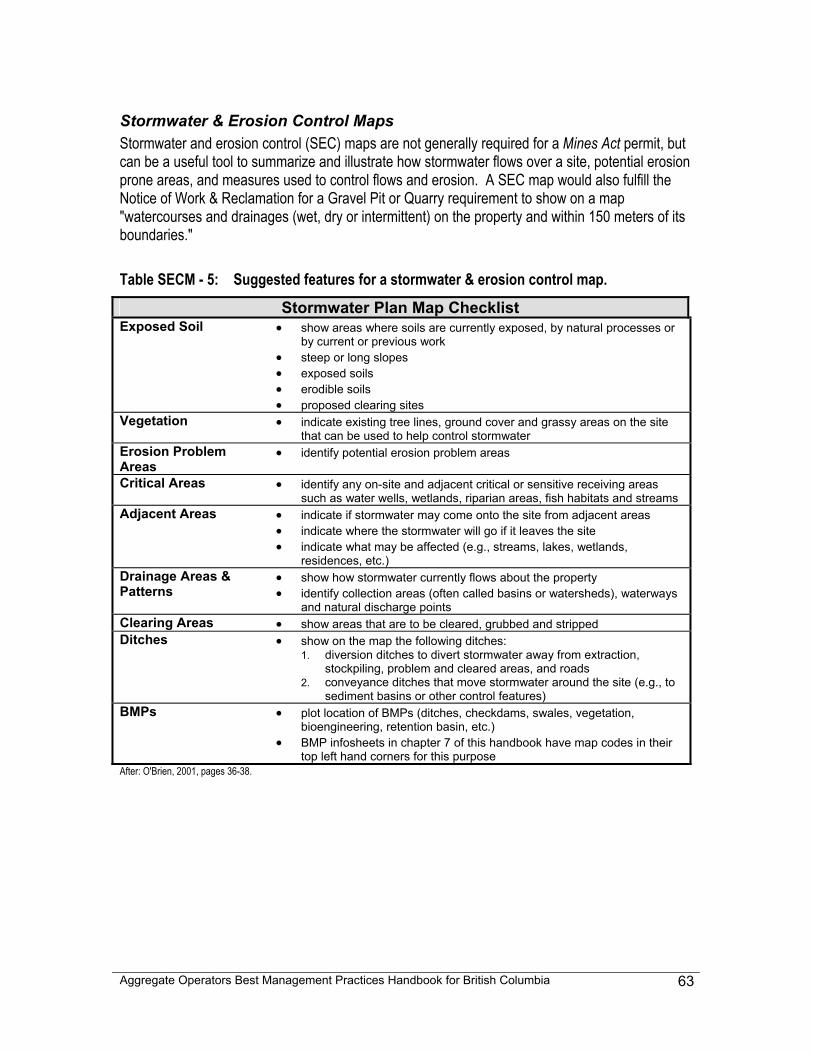
Aggregate Operators Best Management Practices Handbook for British Columbia
63
Stormwater & Erosion Control Maps Stormwater and erosion control (SEC) maps are not generally required for a Mines Act permit, but can be a useful tool to summarize and illustrate how stormwater flows over a site, potential erosion prone areas, and measures used to control flows and erosion. A SEC map would also fulfill the Notice of Work & Reclamation for a Gravel Pit or Quarry requirement to show on a map "watercourses and drainages (wet, dry or intermittent) on the property and within 150 meters of its boundaries." Table SECM - 5: Suggested features for a stormwater & erosion control map.
Stormwater Plan Map Checklist Exposed Soil • show areas where soils are currently exposed, by natural processes or
by current or previous work • steep or long slopes • exposed soils • erodible soils • proposed clearing sites
Vegetation • indicate existing tree lines, ground cover and grassy areas on the site that can be used to help control stormwater
Erosion Problem Areas
• identify potential erosion problem areas
Critical Areas • identify any on-site and adjacent critical or sensitive receiving areas such as water wells, wetlands, riparian areas, fish habitats and streams
Adjacent Areas • indicate if stormwater may come onto the site from adjacent areas • indicate where the stormwater will go if it leaves the site • indicate what may be affected (e.g., streams, lakes, wetlands,
residences, etc.) Drainage Areas & Patterns
• show how stormwater currently flows about the property • identify collection areas (often called basins or watersheds), waterways
and natural discharge points Clearing Areas • show areas that are to be cleared, grubbed and stripped Ditches • show on the map the following ditches:
1. diversion ditches to divert stormwater away from extraction, stockpiling, problem and cleared areas, and roads
2. conveyance ditches that move stormwater around the site (e.g., to sediment basins or other control features)
BMPs • plot location of BMPs (ditches, checkdams, swales, vegetation, bioengineering, retention basin, etc.)
• BMP infosheets in chapter 7 of this handbook have map codes in their top left hand corners for this purpose
After: O'Brien, 2001, pages 36-38.
Aggregate Operators Best Management Practices Handbook for British Columbia
64
5 - 6 BY-PRODUCT & WASTE MODULE - BWM
Common Concerns: Aggregate By-products & Waste Most aggregate operations generate by-products and waste that, if not managed expediently, can cause space control problems, add to costs and potentially be detrimental to the environment. Aggregate by-products are overburden that is moved in order to access resources, screenings and settling-pond fines. These by-product materials are generally of low unit value, and extra handling to dispose of them represents added costs. Where markets can be found for by-products, cost recovery is often the best that an operator can anticipate. Finding timely and effective uses or applications for aggregate by-products can be a challenge for many operators. Waste generated at aggregate sites generally includes garbage, used petroleum products and other non-mineral materials. Effectively managing waste means reducing its production, planning for the space and containment to adequately handle the material, and arranging for cost-effective and appropriate disposal in accordance with applicable regulations. Planning to handle waste properly and promptly may prevent subsequent time-consuming and costly remedial action. Sand and gravel pits are often located in areas of high permeability, sometimes even in groundwater recharge areas. Waste management at these sites should recognize and account for the greater risk associated with high permeability areas. Furthermore, aggregate operations should handle waste in a manner that will not negatively impact subsequent land uses.
Planning for by-products and waste management includes identifying the types and volumes of produced materials, developing procedures for handling these materials, and finding applications or depots for their disposition. Minimizing handling will benefit both the producer and the end user. This module recommends four basic strategies of by-product and waste management:
• minimizing their production, • planning for space to handle/store them, • finding uses or destination sites, and • minimizing handling.
What Are Aggregate By-products By-products at aggregate operations are any materials that are not sold as a primary product. Table BWM - 1 lists and describes some by-products. Note that topsoil is not generally considered to be either a by-product or a marketable product, and often has to be saved on the site for reclamation.
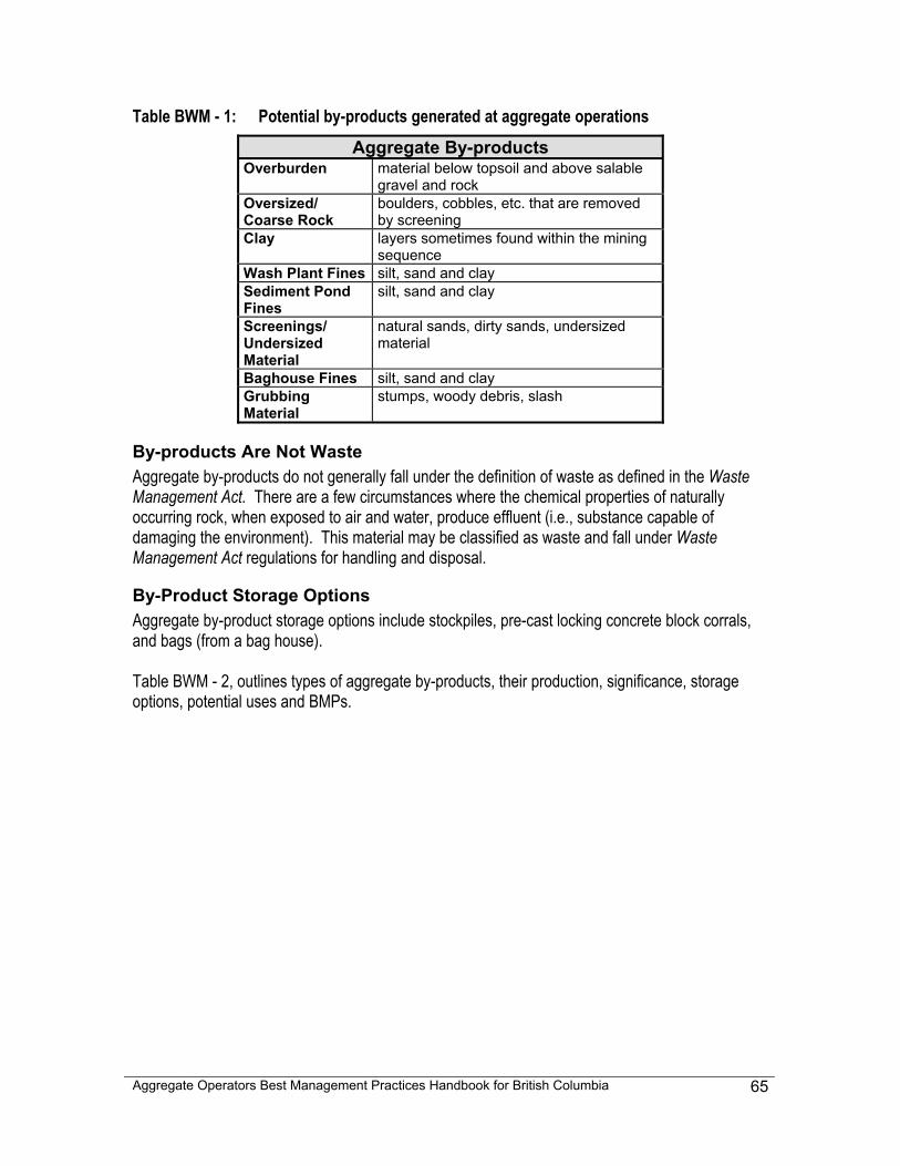
Aggregate Operators Best Management Practices Handbook for British Columbia
65
Table BWM - 1: Potential by-products generated at aggregate operations Aggregate By-products
Overburden material below topsoil and above salable gravel and rock
Oversized/ Coarse Rock
boulders, cobbles, etc. that are removed by screening
Clay layers sometimes found within the mining sequence
Wash Plant Fines silt, sand and clay Sediment Pond Fines
silt, sand and clay
Screenings/ Undersized Material
natural sands, dirty sands, undersized material
Baghouse Fines silt, sand and clay Grubbing Material
stumps, woody debris, slash
By-products Are Not Waste Aggregate by-products do not generally fall under the definition of waste as defined in the Waste Management Act. There are a few circumstances where the chemical properties of naturally occurring rock, when exposed to air and water, produce effluent (i.e., substance capable of damaging the environment). This material may be classified as waste and fall under Waste Management Act regulations for handling and disposal.
By-Product Storage Options Aggregate by-product storage options include stockpiles, pre-cast locking concrete block corrals, and bags (from a bag house). Table BWM - 2, outlines types of aggregate by-products, their production, significance, storage options, potential uses and BMPs.
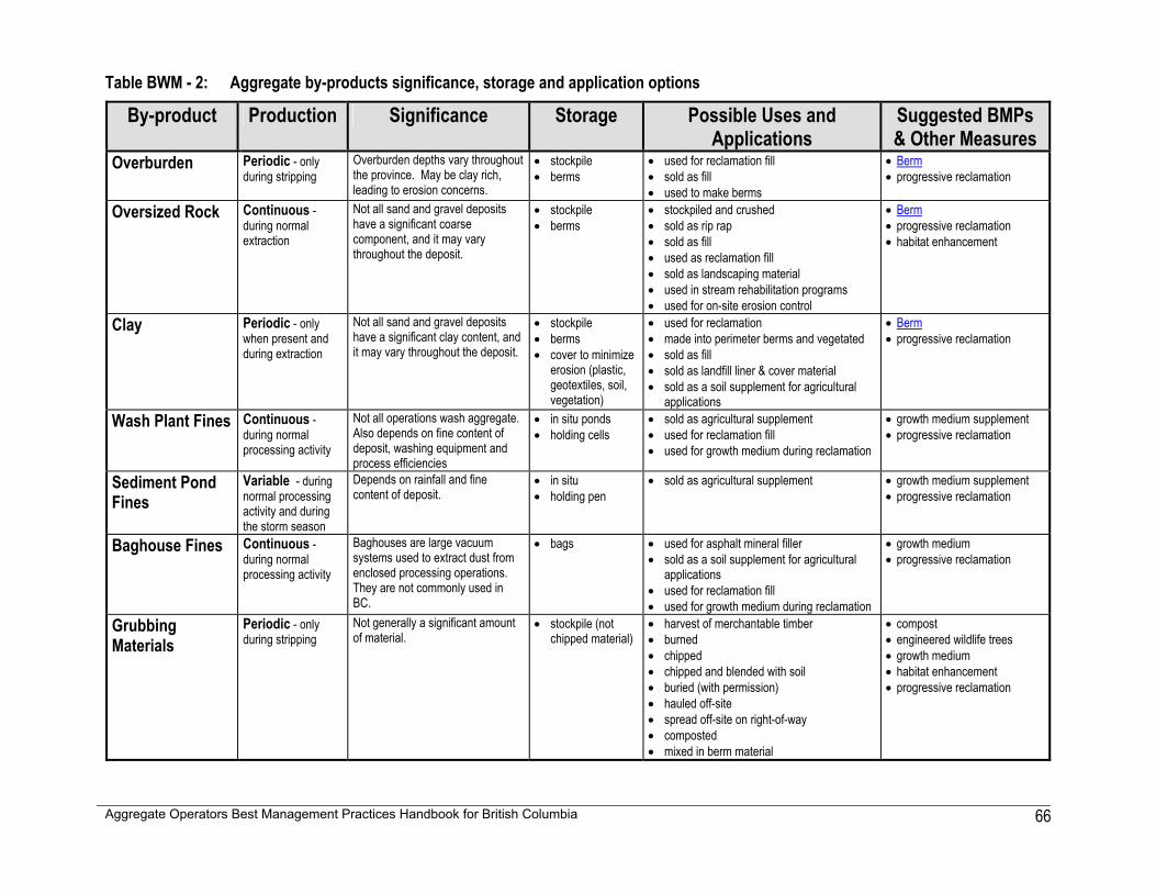
Aggregate Operators Best Management Practices Handbook for British Columbia
66
Table BWM - 2: Aggregate by-products significance, storage and application options
By-product Production Significance Storage Possible Uses and Applications
Suggested BMPs & Other Measures
Overburden Periodic - only during stripping
Overburden depths vary throughout the province. May be clay rich, leading to erosion concerns.
• stockpile • berms
• used for reclamation fill • sold as fill • used to make berms
• Berm • progressive reclamation
Oversized Rock Continuous -during normal extraction
Not all sand and gravel deposits have a significant coarse component, and it may vary throughout the deposit.
• stockpile • berms
• stockpiled and crushed • sold as rip rap • sold as fill • used as reclamation fill • sold as landscaping material • used in stream rehabilitation programs • used for on-site erosion control
• Berm • progressive reclamation • habitat enhancement
Clay Periodic - only when present and during extraction
Not all sand and gravel deposits have a significant clay content, and it may vary throughout the deposit.
• stockpile • berms • cover to minimize
erosion (plastic, geotextiles, soil, vegetation)
• used for reclamation • made into perimeter berms and vegetated • sold as fill • sold as landfill liner & cover material • sold as a soil supplement for agricultural
applications
• Berm • progressive reclamation
Wash Plant Fines Continuous -during normal processing activity
Not all operations wash aggregate. Also depends on fine content of deposit, washing equipment and process efficiencies
• in situ ponds • holding cells
• sold as agricultural supplement • used for reclamation fill • used for growth medium during reclamation
• growth medium supplement • progressive reclamation
Sediment Pond Fines
Variable - during normal processing activity and during the storm season
Depends on rainfall and fine content of deposit.
• in situ • holding pen
• sold as agricultural supplement • growth medium supplement • progressive reclamation
Baghouse Fines Continuous -during normal processing activity
Baghouses are large vacuum systems used to extract dust from enclosed processing operations. They are not commonly used in BC.
• bags • used for asphalt mineral filler • sold as a soil supplement for agricultural
applications • used for reclamation fill • used for growth medium during reclamation
• growth medium • progressive reclamation
Grubbing Materials
Periodic - only during stripping
Not generally a significant amount of material.
• stockpile (not chipped material)
• harvest of merchantable timber • burned • chipped • chipped and blended with soil • buried (with permission) • hauled off-site • spread off-site on right-of-way • composted • mixed in berm material
• compost • engineered wildlife trees • growth medium • habitat enhancement • progressive reclamation
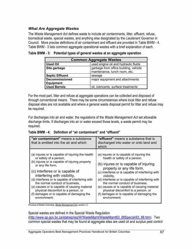
Aggregate Operators Best Management Practices Handbook for British Columbia
67
What Are Aggregate Wastes The Waste Management Act defines waste to include air contaminants, litter, effluent, refuse, biomedical waste, special wastes, and anything else designated by the Lieutenant Governor in Council. More precise definitions of air contaminant and effluent are provided in Table BWM - 4. Table BWM - 3 lists common aggregate operational wastes with a brief explanation of each. Table BWM - 3: Potential types of general wastes at an aggregate operation
Common Aggregate Wastes Used Oil used engine oil and hydraulic fluids Site garbage garbage from office building, vehicle
maintenance, lunch room, etc. Septic Effluent sewage Decommissioned Equipment
major equipment and attachments
Used Barrels oil, lubricants, surface treatments For the most part, litter and refuse at aggregate operations can be collected and disposed of through conventional means. There may be some circumstances where local litter and refuse disposal sites are not available and where a general waste disposal permit for litter and refuse may be required. For discharges into air and water, the regulations of the Waste Management Act set allowable discharge limits. If discharges into air or water exceed those levels, a waste permit may be required. Table BWM - 4: Definition of “air contaminant” and “effluent”
"air contaminant" means a substance that is emitted into the air and which
"effluent" means a substance that is discharged into water or onto land and which
(a) injures or is capable of injuring the health
or safety of a person, (b) injures or is capable of injuring property
or any life form,
(c) interferes or is capable of interfering with visibility,
(d) interferes or is capable of interfering with the normal conduct of business,
(e) causes or is capable of causing material physical discomfort to a person, or
(f) damages or is capable of damaging the environment;
(a) injures or is capable of injuring the
health or safety of a person,
(b) injures or is capable of injuring property or any life form,
(c) interferes or is capable of interfering with visibility,
(d) interferes or is capable of interfering with the normal conduct of business,
(e) causes or is capable of causing material physical discomfort to a person, or
(f) damages or is capable of damaging the environment;
Province of British Columbia, Waste Management Act, section (1) Special wastes are defined in the Special Waste Regulation (http://www.qp.gov.bc.ca/statreg/reg/W/WasteMgmt/WasteMgmt63_88Special/63_88.htm). Two common special wastes that may be found at aggregate sites are used oil and surplus pest control
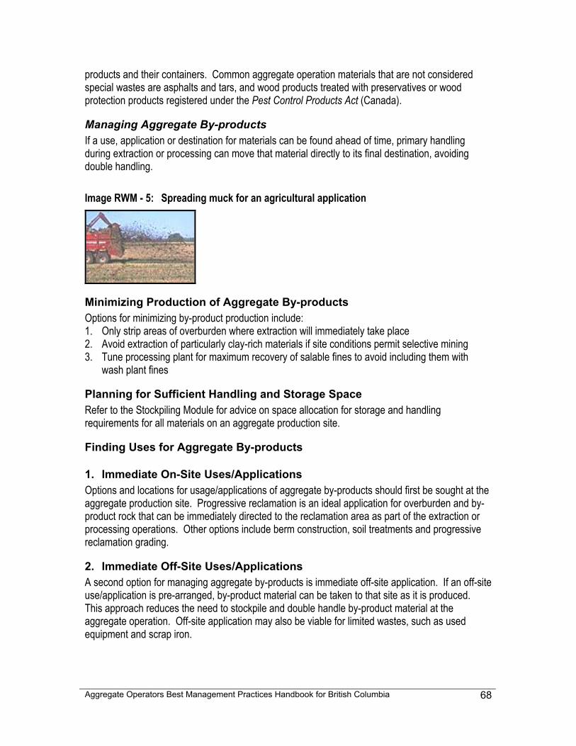
Aggregate Operators Best Management Practices Handbook for British Columbia
68
products and their containers. Common aggregate operation materials that are not considered special wastes are asphalts and tars, and wood products treated with preservatives or wood protection products registered under the Pest Control Products Act (Canada).
Managing Aggregate By-products If a use, application or destination for materials can be found ahead of time, primary handling during extraction or processing can move that material directly to its final destination, avoiding double handling. Image RWM - 5: Spreading muck for an agricultural application
Minimizing Production of Aggregate By-products Options for minimizing by-product production include: 1. Only strip areas of overburden where extraction will immediately take place 2. Avoid extraction of particularly clay-rich materials if site conditions permit selective mining 3. Tune processing plant for maximum recovery of salable fines to avoid including them with
wash plant fines
Planning for Sufficient Handling and Storage Space Refer to the Stockpiling Module for advice on space allocation for storage and handling requirements for all materials on an aggregate production site.
Finding Uses for Aggregate By-products
1. Immediate On-Site Uses/Applications Options and locations for usage/applications of aggregate by-products should first be sought at the aggregate production site. Progressive reclamation is an ideal application for overburden and by-product rock that can be immediately directed to the reclamation area as part of the extraction or processing operations. Other options include berm construction, soil treatments and progressive reclamation grading.
2. Immediate Off-Site Uses/Applications A second option for managing aggregate by-products is immediate off-site application. If an off-site use/application is pre-arranged, by-product material can be taken to that site as it is produced. This approach reduces the need to stockpile and double handle by-product material at the aggregate operation. Off-site application may also be viable for limited wastes, such as used equipment and scrap iron.
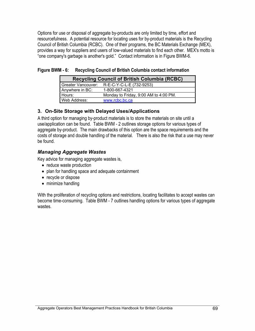
Aggregate Operators Best Management Practices Handbook for British Columbia
69
Options for use or disposal of aggregate by-products are only limited by time, effort and resourcefulness. A potential resource for locating uses for by-product materials is the Recycling Council of British Columbia (RCBC). One of their programs, the BC Materials Exchange (MEX), provides a way for suppliers and users of low-valued materials to find each other. MEX's motto is “one company's garbage is another's gold.” Contact information is in Figure BWM-6. Figure BWM - 6: Recycling Council of British Columbia contact information
Recycling Council of British Columbia (RCBC) Greater Vancouver: R-E-C-Y-C-L-E (732-9253) Anywhere in BC: 1-800-667-4321 Hours: Monday to Friday, 9:00 AM to 4:00 PM. Web Address: www.rcbc.bc.ca
3. On-Site Storage with Delayed Uses/Applications A third option for managing by-product materials is to store the materials on site until a use/application can be found. Table BWM - 2 outlines storage options for various types of aggregate by-product. The main drawbacks of this option are the space requirements and the costs of storage and double handling of the material. There is also the risk that a use may never be found.
Managing Aggregate Wastes Key advice for managing aggregate wastes is,
• reduce waste production • plan for handling space and adequate containment • recycle or dispose • minimize handling
With the proliferation of recycling options and restrictions, locating facilitates to accept wastes can become time-consuming. Table BWM - 7 outlines handling options for various types of aggregate wastes.
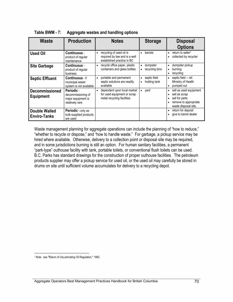
Aggregate Operators Best Management Practices Handbook for British Columbia
70
Table BWM - 7: Aggregate wastes and handling options
Waste Production Notes Storage Disposal Options
Used Oil Continuous - product of regular maintenance
• recycling of used oil is required by law and is a well established practice in BC
• barrels • return to seller1 • collected by recycler
Site Garbage Continuous - product of regular business
• recycle office paper, plastic containers and glass bottles
• dumpster • recycling bins
• dumpster pickup • burning • recycling
Septic Effluent Continuous - if municipal sewer system is not available
• portable and permanent septic solutions are readily available
• septic field • holding tank
• septic field -- ref. Ministry of Health
• pumped out Decommissioned Equipment
Periodic - decommissioning of major equipment is relatively rare
• dependent upon local market for used equipment or scrap metal recycling facilities
• yard • sell as used equipment • sell as scrap • sell for parts • remove to appropriate
waste disposal site. Double Walled Enviro-Tanks
Periodic - only as bulk-supplied products are used
• return for deposit • give to barrel dealer
Waste management planning for aggregate operations can include the planning of “how to reduce,” “whether to recycle or dispose,” and “how to handle waste.” For garbage, a pickup service may be hired where available. Otherwise, delivery to a collection point or disposal site may be required, and in some jurisdictions burning is still an option. For human sanitary facilities, a permanent “park-type” outhouse facility with tank, portable toilets, or conventional flush toilets can be used. B.C. Parks has standard drawings for the construction of proper outhouse facilities. The petroleum products supplier may offer a pickup service for used oil, or the used oil may carefully be stored in drums on site until sufficient volume accumulates for delivery to a recycling depot.
1 Note: see "Return of UsLubricating Oil Regulation," 1992.
Aggregate Operators Best Management Practices Handbook for British Columbia
71
5-7 SITE LAYOUT MODULE - SLM
Common Concerns: Site Layout Site layout choices can have a strong influence upon the potential community impacts of an aggregate operation, particularly where it concerns noise, dust and visual aesthetics. This module discusses, in separate sections, site layout with respect to controlling noise, dust and visual landscape impacts and recommends that a Site Layout Map be constructed to help understand and address these concerns.
Noise Noise is one of the most commonly cited community concerns regarding aggregate operations. As Table MP - 4: Mine Plan Activity And Module Worksheet in Chapter 4 indicates, noise is associated with a great number of common activities at aggregate operations, including blasting, loading, crushing, screening, washing and hauling. This module will assist in identifying noise point sources at aggregate operations and BMPs and other measures that can be used to minimize noise.
Dust In both urban and rural environments, neighbours of aggregate operations commonly voice concerns about dust. The disturbance of fine soils by extraction and processing activities at sand and gravel pits and rock quarries increases the potential for dust creation, and dust control should be part of ongoing operations. This module will assist in identifying dust-generating activities, situations where dust can be an issue, which people and facilities are sensitive to dust, and what BMPs and other measures can be used to control dust.
Visual Landscape Design An aggregate operation's appearance may significantly affect the relationship between the aggregate operation and its host community. With increasing environmental and public land use interest in the aggregate industry, managing the appearance of an operation has become an important priority. Visual landscape planning can help to strike a balance between the aesthetic concerns of the community and the economic and operational validity of the operation. Through the provincial land use planning process, the Province is currently performing a Visual Landscape Inventory. This process involves establishing visual quality objectives, classifying landscapes and designating significant scenic areas. In some areas of the province, visual quality objectives may have to be met for a subsequent permit to be granted, similar to a licence to cut for forestry activities. With British Columbia’s world-renowned landscapes proclaimed on every licence plate, and with the developing of the tourist and movie industries, viewscapes are regarded as a provincial resource that, where possible, should be considered at aggregate operations during their productive life spans.
Aggregate Operators Best Management Practices Handbook for British Columbia
72
Section 1 - Noise
Aggregate Operation Noise Management Planning to manage noise at an aggregate operation can include:
• identifying activities that generate noise, • determining how the configuration of the property amplifies, muffles or reflects noise, • developing measures and BMPs to reduce noise generation, and • developing measures and BMPs to reduce the transmission of noise.
Understanding Noise The intensity of sound is measured in units called decibels (dB) and is expressed on a logarithmic scale. As such, combining sound levels is not a matter of simple addition. For example 50 dB + 50 dB = 53 dB, not 100 dB. An increase of 3 dB in sound intensity doubles the sound energy, or loudness. Likewise, a 12 dB increase in intensity represents an 800% increase in loudness. Different criteria are used to measure sound for different purposes. Criteria used to approximate the sounds heard by the human ear, called “A-weighting”, are recorded in dBA. Other measuring options include comparing sound levels over time (Leq), measuring its steady state, or measuring the peak (impact) level. Noise sources at aggregate operations can include equipment engines, back-up alarms, drills, power generators (“gen sets”), crushers, screens, material falling on to a grizzly or into the empty metal box of a haul truck, the 'body slap' of empty truck boxes, squealing of tracked vehicles, and even the rattle of loose hitches or boxes on trucks travelling through the neighbourhood. Noise control can include scheduling hours of operation, selecting appropriate equipment (e.g., does it have a proper muffler?), constructing sound barriers and berms to contain noise and other options. The effects of aggregate operational noise on neighbours can vary, but may cause annoyance, disturbance and even a sense of interference with quality of life. Factors to consider include hours of operation (especially early morning), frequency of vehicle traffic on local roads, steps taken to contain noise emissions and, of course, how close the operation is to neighbouring houses. Wildlife, livestock and even fish may also be affected by noise exposure. Fisheries and Oceans Canada's (DFO) Guidelines for the Use of Explosives in or Near Canadian Fisheries Waters recommends set-back distances for specific substrates and weights of explosive charges (Wright and Hopky, 1998).
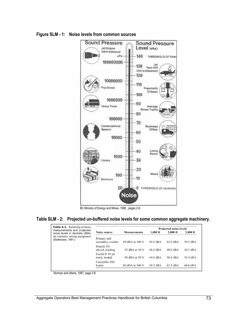
Aggregate Operators Best Management Practices Handbook for British Columbia
73
Figure SLM - 1: Noise levels from common sources
BC Ministry of Energy and Mines, 1998 , pages 2-9.
Table SLM - 2: Projected un-buffered noise levels for some common aggregate machinery.
Norman and others, 1997, page 3-8.
.
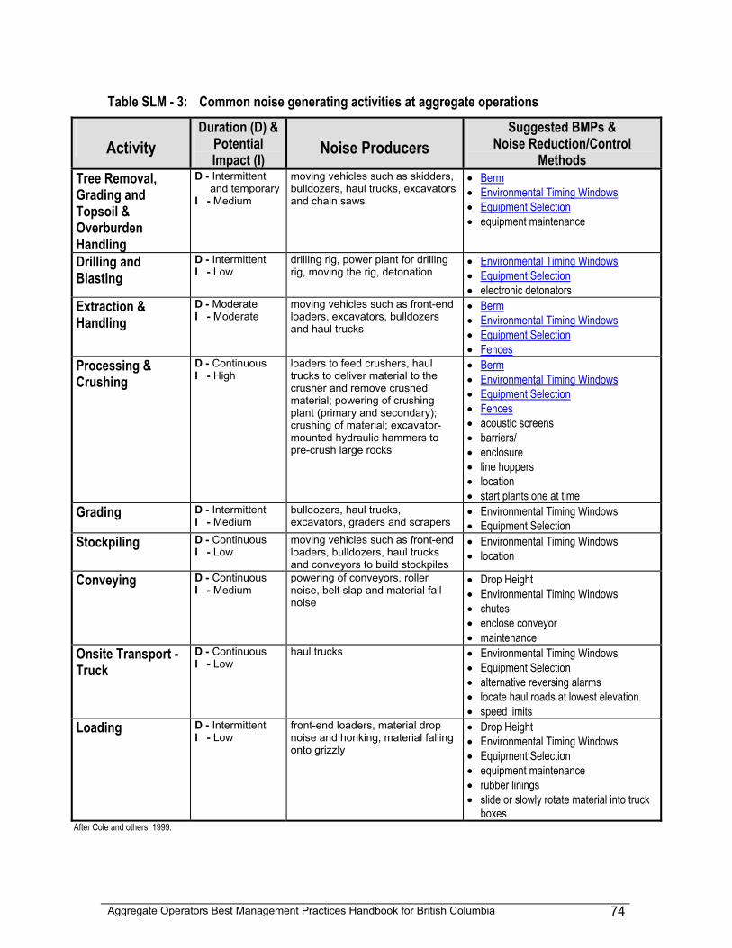
Aggregate Operators Best Management Practices Handbook for British Columbia
74
Table SLM - 3: Common noise generating activities at aggregate operations
Activity
Duration (D) & Potential Impact (I)
Noise Producers
Suggested BMPs & Noise Reduction/Control
Methods Tree Removal, Grading and Topsoil & Overburden Handling
D - Intermittent and temporary
I - Medium
moving vehicles such as skidders, bulldozers, haul trucks, excavators and chain saws
• Berm • Environmental Timing Windows • Equipment Selection • equipment maintenance
Drilling and Blasting
D - Intermittent I - Low
drilling rig, power plant for drilling rig, moving the rig, detonation
• Environmental Timing Windows • Equipment Selection • electronic detonators
Extraction & Handling
D - Moderate I - Moderate
moving vehicles such as front-end loaders, excavators, bulldozers and haul trucks
• Berm • Environmental Timing Windows • Equipment Selection • Fences
Processing & Crushing
D - Continuous I - High
loaders to feed crushers, haul trucks to deliver material to the crusher and remove crushed material; powering of crushing plant (primary and secondary); crushing of material; excavator-mounted hydraulic hammers to pre-crush large rocks
• Berm • Environmental Timing Windows • Equipment Selection • Fences • acoustic screens • barriers/ • enclosure • line hoppers • location • start plants one at time
Grading D - Intermittent I - Medium
bulldozers, haul trucks, excavators, graders and scrapers
• Environmental Timing Windows • Equipment Selection
Stockpiling D - Continuous I - Low
moving vehicles such as front-end loaders, bulldozers, haul trucks and conveyors to build stockpiles
• Environmental Timing Windows • location
Conveying D - Continuous I - Medium
powering of conveyors, roller noise, belt slap and material fall noise
• Drop Height • Environmental Timing Windows • chutes • enclose conveyor • maintenance
Onsite Transport - Truck
D - Continuous I - Low
haul trucks • Environmental Timing Windows • Equipment Selection • alternative reversing alarms • locate haul roads at lowest elevation. • speed limits
Loading D - Intermittent I - Low
front-end loaders, material drop noise and honking, material falling onto grizzly
• Drop Height • Environmental Timing Windows • Equipment Selection • equipment maintenance • rubber linings • slide or slowly rotate material into truck
boxes After Cole and others, 1999.
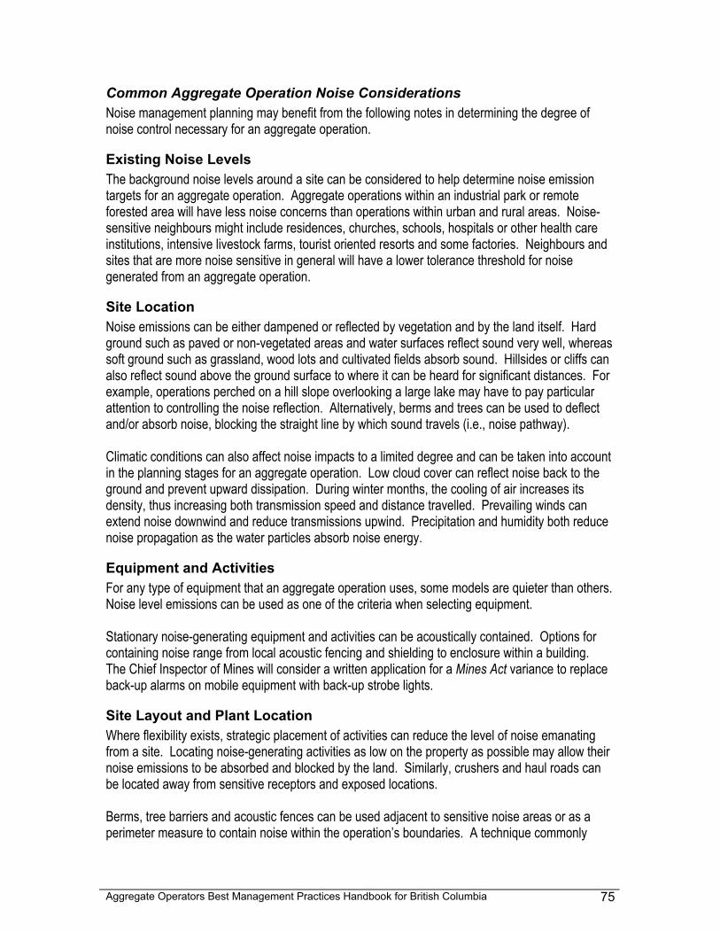
Aggregate Operators Best Management Practices Handbook for British Columbia
75
Common Aggregate Operation Noise Considerations Noise management planning may benefit from the following notes in determining the degree of noise control necessary for an aggregate operation.
Existing Noise Levels The background noise levels around a site can be considered to help determine noise emission targets for an aggregate operation. Aggregate operations within an industrial park or remote forested area will have less noise concerns than operations within urban and rural areas. Noise-sensitive neighbours might include residences, churches, schools, hospitals or other health care institutions, intensive livestock farms, tourist oriented resorts and some factories. Neighbours and sites that are more noise sensitive in general will have a lower tolerance threshold for noise generated from an aggregate operation.
Site Location Noise emissions can be either dampened or reflected by vegetation and by the land itself. Hard ground such as paved or non-vegetated areas and water surfaces reflect sound very well, whereas soft ground such as grassland, wood lots and cultivated fields absorb sound. Hillsides or cliffs can also reflect sound above the ground surface to where it can be heard for significant distances. For example, operations perched on a hill slope overlooking a large lake may have to pay particular attention to controlling the noise reflection. Alternatively, berms and trees can be used to deflect and/or absorb noise, blocking the straight line by which sound travels (i.e., noise pathway). Climatic conditions can also affect noise impacts to a limited degree and can be taken into account in the planning stages for an aggregate operation. Low cloud cover can reflect noise back to the ground and prevent upward dissipation. During winter months, the cooling of air increases its density, thus increasing both transmission speed and distance travelled. Prevailing winds can extend noise downwind and reduce transmissions upwind. Precipitation and humidity both reduce noise propagation as the water particles absorb noise energy.
Equipment and Activities For any type of equipment that an aggregate operation uses, some models are quieter than others. Noise level emissions can be used as one of the criteria when selecting equipment. Stationary noise-generating equipment and activities can be acoustically contained. Options for containing noise range from local acoustic fencing and shielding to enclosure within a building. The Chief Inspector of Mines will consider a written application for a Mines Act variance to replace back-up alarms on mobile equipment with back-up strobe lights.
Site Layout and Plant Location Where flexibility exists, strategic placement of activities can reduce the level of noise emanating from a site. Locating noise-generating activities as low on the property as possible may allow their noise emissions to be absorbed and blocked by the land. Similarly, crushers and haul roads can be located away from sensitive receptors and exposed locations. Berms, tree barriers and acoustic fences can be used adjacent to sensitive noise areas or as a perimeter measure to contain noise within the operation’s boundaries. A technique commonly
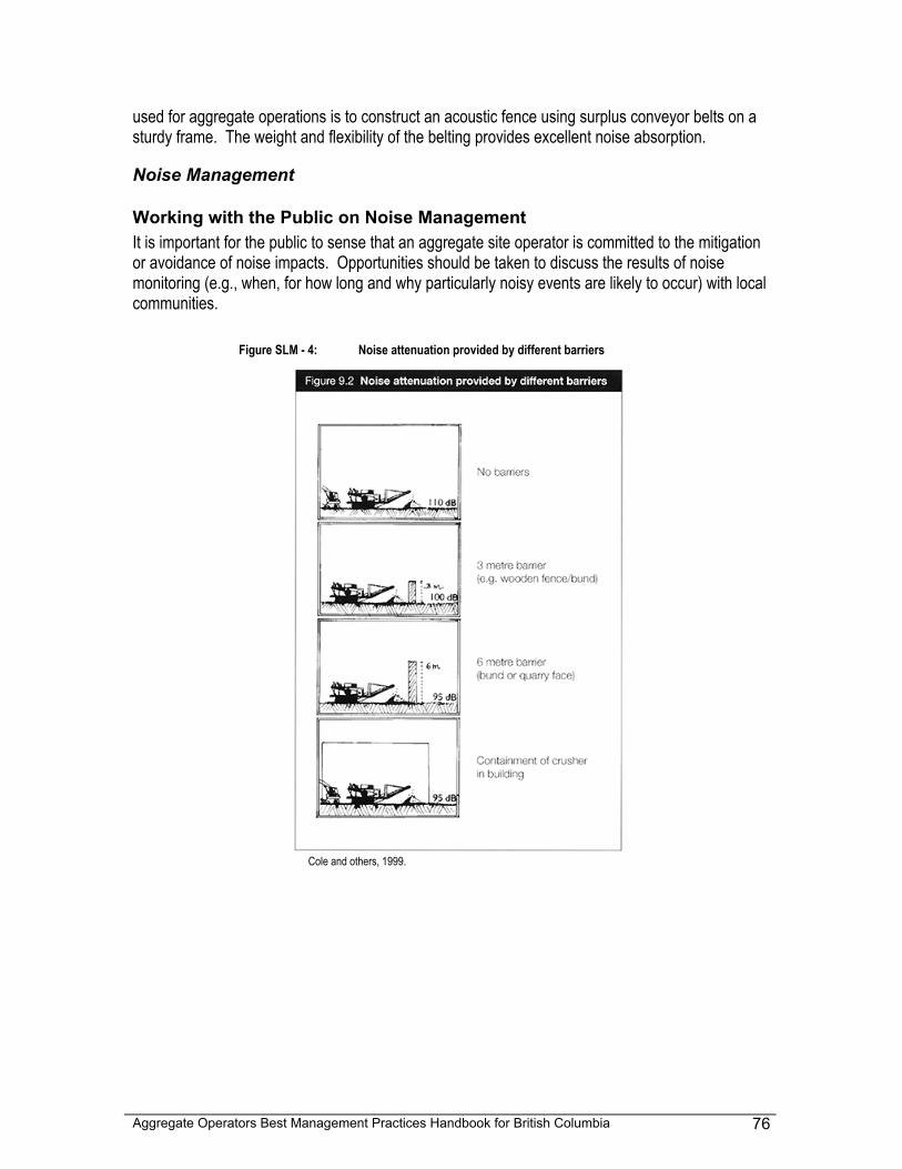
Aggregate Operators Best Management Practices Handbook for British Columbia
76
used for aggregate operations is to construct an acoustic fence using surplus conveyor belts on a sturdy frame. The weight and flexibility of the belting provides excellent noise absorption.
Noise Management
Working with the Public on Noise Management It is important for the public to sense that an aggregate site operator is committed to the mitigation or avoidance of noise impacts. Opportunities should be taken to discuss the results of noise monitoring (e.g., when, for how long and why particularly noisy events are likely to occur) with local communities.
Figure SLM - 4: Noise attenuation provided by different barriers
Cole and others, 1999.
Aggregate Operators Best Management Practices Handbook for British Columbia
77
Some operators have successfully implemented community response systems to address noise-related complaints in a fair and expedient manner. A record of complaints, the actions taken, outstanding follow-up actions and subsequent dialogue with complainants are some measures that have been practiced with success.
Methods For Reducing And Controlling Noise Noise can be controlled at aggregate operations by a number of strategies such as:
• source control, • containment, • site layout (stationary objects), • operations (activities or moving objects) and • interception (perimeter structures).
Careful site planning can help to contain the noise with the use of the existing topography, existing and introduced vegetation, major landscaping (berms), acoustic fences, tree barriers and combinations of these methods. Operational practices can reduce both the generation and the escape of noise. Finally, interception can be achieved with property edge treatments such as perimeter barriers composed of trees and shrubs or acoustic fences specifically designed to intercept ambient noises. Table SLM - 5 outlines these suggestions with associated BMPs.
Noise Planning Considerations Noise planning for an aggregate operation encompasses both the planning of the site layout and the development of operational procedures. Although a Site Layout Map is not generally a permit requirement, the plan for noise (as well as dust and visual) considerations could be worked out and documented on such a map. A Site Layout Map could contain the following noise components:
• noise-generating activities, • off-site facilities that are noise-sensitive , • potential noise reflectors (mine faces, hillsides, hard ground and water), topographic
hollows and noise absorbing areas (wood lots, shrub areas, grasses), • placement of berms, stockpiles and tree buffers to create or enhance noise-dampening
locations for the site or to act as noise barriers, • plans to locate noise-generating activities and haul roads in suppressing locations and
away far from noise-sensitive facilities, • procedures to avoid noise generation and contain noise, and • Designation of existing trees and shrubs as perimeter barriers on noise sensitive sides
of the operation.
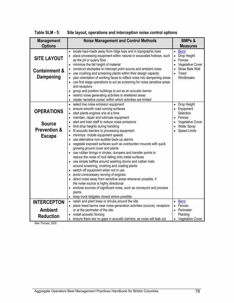
Aggregate Operators Best Management Practices Handbook for British Columbia
78
Table SLM - 5: Site layout, operations and interception noise control options
Management Options
Noise Management and Control Methods BMPs & Measures
SITE LAYOUT
Containment &
Dampening
• locate haul-roads away from ridge tops and in topographic lows • place processing equipment within natural or excavated hollows, such
as the pit or quarry floor • minimize the fall height of material • construct stockpiles to intercept point source and ambient noise • use crushing and screening plants within their design capacity • plan orientation of working faces to reflect noise into dampening areas • use first stage operations to act as screening for noise sensitive areas
and receptors • group and position buildings to act as an acoustic barrier • restrict noise generating activities to sheltered areas • create 'sensitive zones' within which activities are limited
• Berm • Drop Height • Fences • Vegetative Cover • Straw Bale Wall • Treed
Windbreaks
OPERATIONS
Source
Prevention & Escape
• select low noise emission equipment • ensure smooth road running surfaces • start plants engines one at a time • maintain, repair and lubricate equipment • alert and train staff to reduce noise emissions • limit drop heights during handling • fit acoustic barriers to processing equipment • minimize mobile equipment speeds • use alternative non-audible back-up alarms • vegetate exposed surfaces such as overburden mounds with quick
growing ground cover and plants • use rubber linings in chutes, dumpers and transfer points to
reduce the noise of rock falling onto metal surfaces • use simple baffles around washing drums and rubber mats
around screening, crushing and coating plants • switch off equipment when not in use • avoid unnecessary revving of engines • direct noise away from sensitive areas whenever possible, if
the noise source is highly directional • enclose sources of significant noise, such as conveyors and process
plants • keep truck tailgates closed where possible
• Drop Height • Equipment
Selection • Fences • Vegetative Cover • Water Spray • Speed Limits
INTERCEPTON
Ambient Reduction
• retain and plant trees or shrubs around the site • place treed berms near noise generation activities (source), receptors
or at the perimeter of the site • install acoustic fencing • ensure there are no gaps in acoustic barriers, as noise will leak out
• Berm • Fences • Perimeter
Planting • Vegetative Cover
After Thomas, 2000.
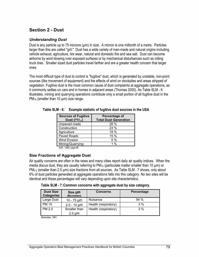
Aggregate Operators Best Management Practices Handbook for British Columbia
79
Section 2 - Dust
Understanding Dust Dust is any particle up to 75 microns (µm) in size. A micron is one millionth of a metre. Particles larger than this are called "grit." Dust has a wide variety of man-made and natural origins including vehicle exhaust, agriculture, tire wear, natural and domestic fire and sea salt. Dust can become airborne by wind blowing over exposed surfaces or by mechanical disturbances such as rolling truck tires. Smaller sized dust particles travel farther and are a greater health concern that larger ones. The most difficult type of dust to control is "fugitive" dust, which is generated by unstable, non-point sources (like movement of equipment) and the effects of wind on stockpiles and areas stripped of vegetation. Fugitive dust is the most common cause of dust complaints at aggregate operations, as it commonly settles on cars and in homes in adjacent areas (Thomas 2000). As Table SLM - 6 illustrates, mining and quarrying operations contribute only a small portion of all fugitive dust in the PM10 (smaller than 10 µm) size range.
Table SLM - 6: Example statistic of fugitive dust sources in the USA Sources of Fugitive
Dust (PM10) Percentage of
Total Dust Generation Unpaved roads 28 % Construction 23 % Agriculture 19 % Paved Roads 15 % Wind Erosion 5 % Mining/Quarrying 1 % Goff , 1999, page 88.
Size Fractions of Aggregate Dust Air quality concerns are often in the news and many cities report daily air quality indices. When the media discus dust, they are usually referring to PM10 (particulate matter smaller than 10 µm) or PM2.5 (smaller than 2.5 µm) size fractions from all sources. As Table SLM - 7 shows, only about 6% of dust particles generated at aggregate operations falls into this category. No two sites will be identical and these percentages will vary depending upon site characteristics.
Table SLM - 7: Common concerns with aggregate dust by size category. Dust Size
Categories Size µm
(Micrometers) Concerns Percentage
Large Dust 10 - 75 µm Nuisance 94 % PM 10 2.5 - 10 µm Health (respiratory) 3 % PM 2.5 Smaller than
2.5 µm Health (respiratory) 3 %
Barksdale, 1991.
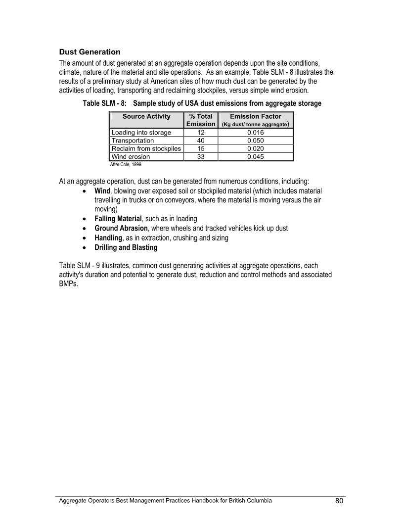
Aggregate Operators Best Management Practices Handbook for British Columbia
80
Dust Generation The amount of dust generated at an aggregate operation depends upon the site conditions, climate, nature of the material and site operations. As an example, Table SLM - 8 illustrates the results of a preliminary study at American sites of how much dust can be generated by the activities of loading, transporting and reclaiming stockpiles, versus simple wind erosion.
Table SLM - 8: Sample study of USA dust emissions from aggregate storage
After Cole, 1999. At an aggregate operation, dust can be generated from numerous conditions, including:
• Wind, blowing over exposed soil or stockpiled material (which includes material travelling in trucks or on conveyors, where the material is moving versus the air moving)
• Falling Material, such as in loading • Ground Abrasion, where wheels and tracked vehicles kick up dust • Handling, as in extraction, crushing and sizing • Drilling and Blasting
Table SLM - 9 illustrates, common dust generating activities at aggregate operations, each activity's duration and potential to generate dust, reduction and control methods and associated BMPs.
Source Activity % Total Emission
Emission Factor (Kg dust/ tonne aggregate)
Loading into storage 12 0.016 Transportation 40 0.050 Reclaim from stockpiles 15 0.020 Wind erosion 33 0.045
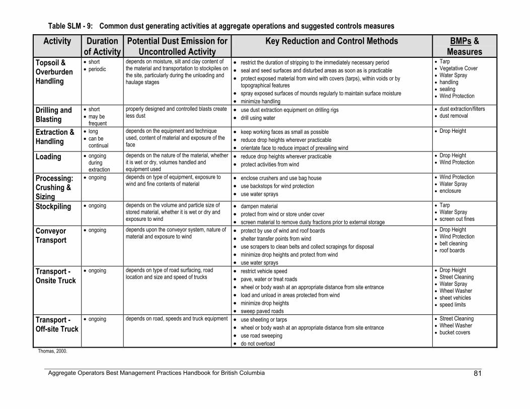
Aggregate Operators Best Management Practices Handbook for British Columbia
81
Table SLM - 9: Common dust generating activities at aggregate operations and suggested controls measures
Activity Duration of Activity
Potential Dust Emission for Uncontrolled Activity
Key Reduction and Control Methods BMPs & Measures
Topsoil & Overburden Handling
• short • periodic
depends on moisture, silt and clay content of the material and transportation to stockpiles on the site, particularly during the unloading and haulage stages
• restrict the duration of stripping to the immediately necessary period • seal and seed surfaces and disturbed areas as soon as is practicable • protect exposed material from wind with covers (tarps), within voids or by
topographical features • spray exposed surfaces of mounds regularly to maintain surface moisture • minimize handling
• Tarp • Vegetative Cover • Water Spray • handling • sealing • Wind Protection
Drilling and Blasting
• short • may be
frequent
properly designed and controlled blasts create less dust
• use dust extraction equipment on drilling rigs • drill using water
• dust extraction/filters • dust removal
Extraction & Handling
• long • can be
continual
depends on the equipment and technique used, content of material and exposure of the face
• keep working faces as small as possible • reduce drop heights wherever practicable • orientate face to reduce impact of prevailing wind
• Drop Height
Loading • ongoing during extraction
depends on the nature of the material, whether it is wet or dry, volumes handled and equipment used
• reduce drop heights wherever practicable • protect activities from wind
• Drop Height • Wind Protection
Processing: Crushing & Sizing
• ongoing depends on type of equipment, exposure to wind and fine contents of material
• enclose crushers and use bag house • use backstops for wind protection • use water sprays
• Wind Protection • Water Spray • enclosure
Stockpiling • ongoing depends on the volume and particle size of stored material, whether it is wet or dry and exposure to wind
• dampen material • protect from wind or store under cover • screen material to remove dusty fractions prior to external storage
• Tarp • Water Spray • screen out fines
Conveyor Transport
• ongoing depends upon the conveyor system, nature of material and exposure to wind
• protect by use of wind and roof boards • shelter transfer points from wind • use scrapers to clean belts and collect scrapings for disposal • minimize drop heights and protect from wind • use water sprays
• Drop Height • Wind Protection • belt cleaning • roof boards
Transport - Onsite Truck
• ongoing depends on type of road surfacing, road location and size and speed of trucks
• restrict vehicle speed • pave, water or treat roads • wheel or body wash at an appropriate distance from site entrance • load and unload in areas protected from wind • minimize drop heights • sweep paved roads
• Drop Height • Street Cleaning • Water Spray • Wheel Washer • sheet vehicles • speed limits
Transport - Off-site Truck
• ongoing depends on road, speeds and truck equipment • use sheeting or tarps • wheel or body wash at an appropriate distance from site entrance • use road sweeping • do not overload
• Street Cleaning • Wheel Washer • bucket covers
Thomas, 2000.
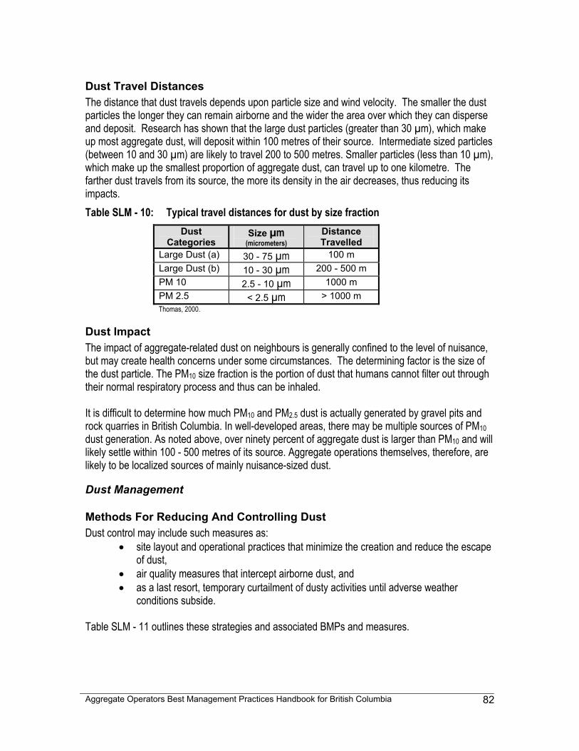
Aggregate Operators Best Management Practices Handbook for British Columbia
82
Dust Travel Distances The distance that dust travels depends upon particle size and wind velocity. The smaller the dust particles the longer they can remain airborne and the wider the area over which they can disperse and deposit. Research has shown that the large dust particles (greater than 30 µm), which make up most aggregate dust, will deposit within 100 metres of their source. Intermediate sized particles (between 10 and 30 µm) are likely to travel 200 to 500 metres. Smaller particles (less than 10 µm), which make up the smallest proportion of aggregate dust, can travel up to one kilometre. The farther dust travels from its source, the more its density in the air decreases, thus reducing its impacts. Table SLM - 10: Typical travel distances for dust by size fraction
Dust Categories
Size µm (micrometers)
Distance Travelled
Large Dust (a) 30 - 75 µm 100 m Large Dust (b) 10 - 30 µm 200 - 500 m PM 10 2.5 - 10 µm 1000 m PM 2.5 < 2.5 µm > 1000 m Thomas, 2000.
Dust Impact The impact of aggregate-related dust on neighbours is generally confined to the level of nuisance, but may create health concerns under some circumstances. The determining factor is the size of the dust particle. The PM10 size fraction is the portion of dust that humans cannot filter out through their normal respiratory process and thus can be inhaled. It is difficult to determine how much PM10 and PM2.5 dust is actually generated by gravel pits and rock quarries in British Columbia. In well-developed areas, there may be multiple sources of PM10 dust generation. As noted above, over ninety percent of aggregate dust is larger than PM10 and will likely settle within 100 - 500 metres of its source. Aggregate operations themselves, therefore, are likely to be localized sources of mainly nuisance-sized dust.
Dust Management
Methods For Reducing And Controlling Dust Dust control may include such measures as:
• site layout and operational practices that minimize the creation and reduce the escape of dust,
• air quality measures that intercept airborne dust, and • as a last resort, temporary curtailment of dusty activities until adverse weather
conditions subside.
Table SLM - 11 outlines these strategies and associated BMPs and measures.
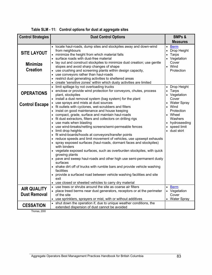
Aggregate Operators Best Management Practices Handbook for British Columbia
83
Table SLM - 11: Control options for dust at aggregate sites
Control Strategies Dust Control Options BMPs & Measures
SITE LAYOUT
Minimize Creation
• locate haul-roads, dump sites and stockpiles away and down-wind from neighbours
• minimize the height from which material falls • surface roads with dust-free material • lay out and construct stockpiles to minimize dust creation; use gentle
slopes and avoid sharp changes of shape • use crushing and screening plants within design capacity, • use conveyors rather than haul-roads • restrict dust generating activities to sheltered areas • create 'sensitive zones' within which dusty activities are limited
• Berm • Drop Height • Tarps • Vegetation
Cover • Wind
Protection
OPERATIONS
Control Escape
• limit spillage by not overloading trucks • enclose or provide wind protection for conveyors, chutes, process
plant, stockpiles • install a dust removal system (bag system) for the plant • use sprays and mists at dust sources • fit outlets with cyclones, wet-scrubbers and filters • insist on good maintenance and house keeping • compact, grade, surface and maintain haul-roads • fit dust extractors, filters and collectors on drilling rigs • use mats when blasting • use wind-breaks/netting screens/semi-permeable fences • limit drop heights • fit wind-boards/hoods at conveyors/transfer points • reduce speeds and limit movement of vehicles, use upswept exhausts • spray exposed surfaces (haul-roads, dormant faces and stockpiles)
with binders • vegetate exposed surfaces, such as overburden stockpiles, with quick
growing plants • pave and sweep haul-roads and other high use semi-permanent dusty
surfaces • shake dirt off of trucks with rumble bars and provide vehicle washing
facilities • provide a surfaced road between vehicle washing facilities and site
exit • use closed or sheeted vehicles to carry dry material
• Drop Height • Tarps • Vegetation
Cover • Water Spray • Wind
Protection • Wheel
Washers • hydroseeding • speed limit • dust skirt
AIR QUALITY Dust Removal
• use trees or shrubs around the site as coarse air filters • place treed berms near dust generators, receptors or at the perimeter
of the site • use sprinklers, sprayers or mist, with or without additives
• Berm • Vegetation
Cover • Water Spray
CESSATION • shut down the operation if, due to unique weather conditions, the extended dispersion of dust cannot be avoided
Thomas, 2000
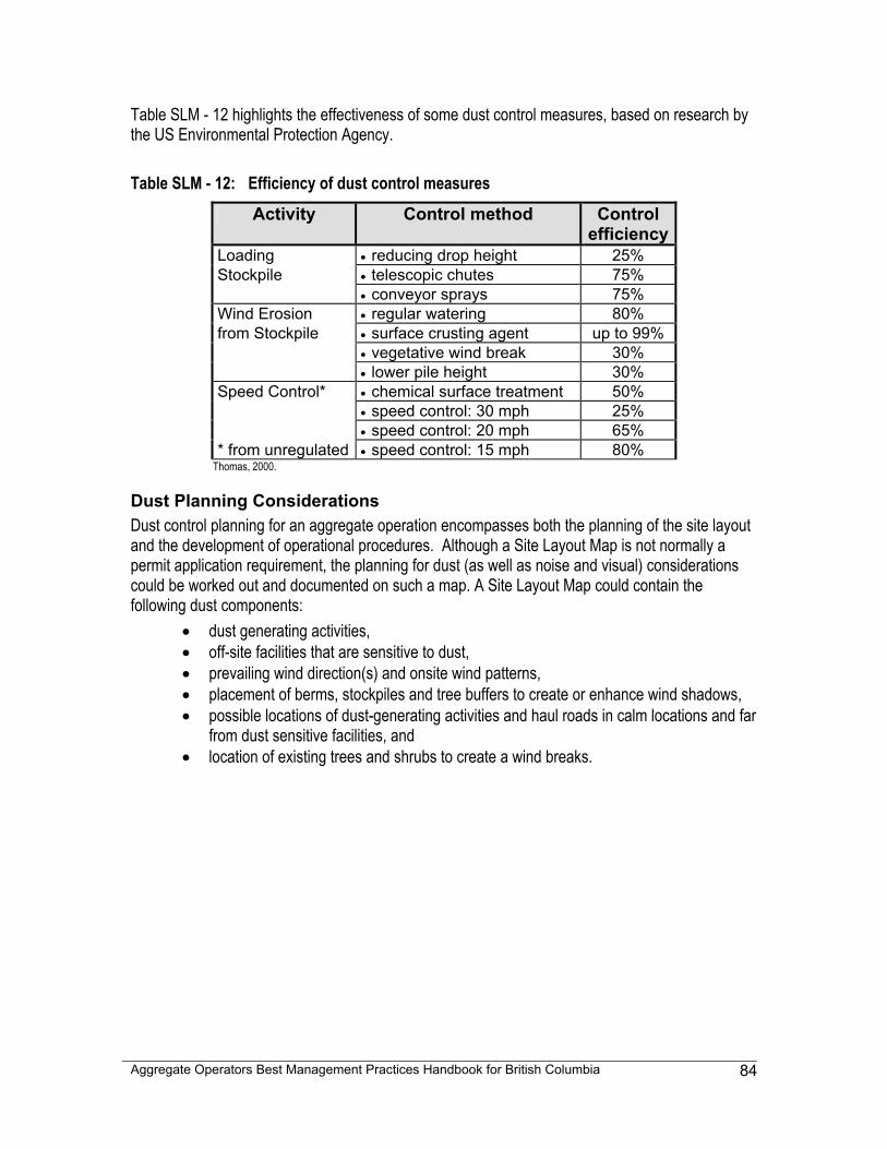
Aggregate Operators Best Management Practices Handbook for British Columbia
84
Table SLM - 12 highlights the effectiveness of some dust control measures, based on research by the US Environmental Protection Agency. Table SLM - 12: Efficiency of dust control measures
Activity Control method Control efficiency
Loading • reducing drop height 25% Stockpile • telescopic chutes 75% • conveyor sprays 75% Wind Erosion • regular watering 80% from Stockpile • surface crusting agent up to 99% • vegetative wind break 30% • lower pile height 30% Speed Control* • chemical surface treatment 50% • speed control: 30 mph 25% • speed control: 20 mph 65% * from unregulated • speed control: 15 mph 80%
Thomas, 2000.
Dust Planning Considerations Dust control planning for an aggregate operation encompasses both the planning of the site layout and the development of operational procedures. Although a Site Layout Map is not normally a permit application requirement, the planning for dust (as well as noise and visual) considerations could be worked out and documented on such a map. A Site Layout Map could contain the following dust components:
• dust generating activities, • off-site facilities that are sensitive to dust, • prevailing wind direction(s) and onsite wind patterns, • placement of berms, stockpiles and tree buffers to create or enhance wind shadows, • possible locations of dust-generating activities and haul roads in calm locations and far
from dust sensitive facilities, and • location of existing trees and shrubs to create a wind breaks.
Aggregate Operators Best Management Practices Handbook for British Columbia
85
Section 3 - Visual Landscape Design
Understanding Visual Landscape Design Many industrial and commercial facilities in British Columbia have used landscape design techniques to improve the appearance of an operation, thereby gaining greater public acceptance. It has been found that the public's views on an aggregate operation are formed as a result of three factors: 1. Landscape
character “it doesn’t fit in” • how the appearance of the operation contrasts in form,
height, mass and colour with the surrounding natural and built landscape (what is visually prominent: topography, soil, vegetation, farming patterns, existing development patterns)
2. Negative
associations “industrial” • perceived negative associations with industrial
operations, dereliction and disturbance
3. Sense of permanence
“ugly forever” • even though aggregate operations are a temporary land use, they are often perceived as permanent
After Nicholson, 1994.
Visual Impacts: Types and Sources The visual impacts of sand and gravel pits and quarries are similar from one operation to another. The two main types of visual impacts are: 1. Obstruction • blocking a pre-existing view, such as with a stockpile
2. Intrusion • when something new is added that seems out of place, such as a very
straight long berm After Nicholson, 1994. Table SLM - 13 lists some of the common causes of visual impacts at aggregate operations.
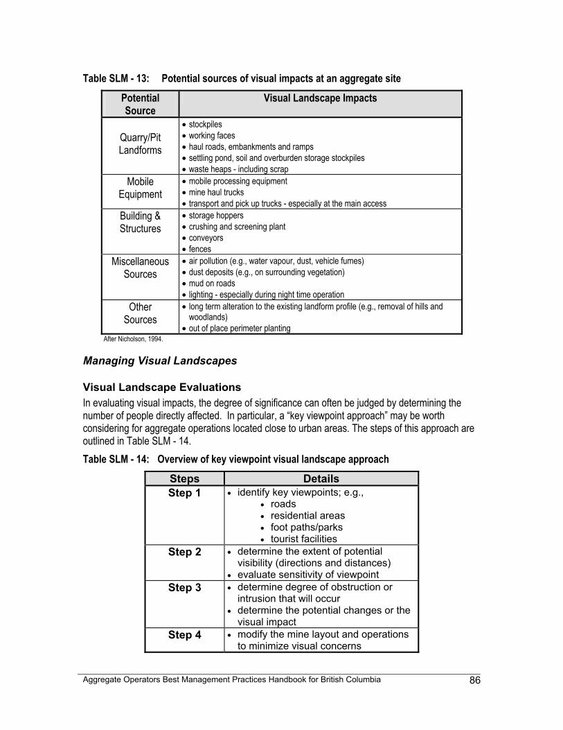
Aggregate Operators Best Management Practices Handbook for British Columbia
86
Table SLM - 13: Potential sources of visual impacts at an aggregate site
Potential Source
Visual Landscape Impacts
Quarry/Pit Landforms
• stockpiles • working faces • haul roads, embankments and ramps • settling pond, soil and overburden storage stockpiles • waste heaps - including scrap
Mobile Equipment
• mobile processing equipment • mine haul trucks • transport and pick up trucks - especially at the main access
Building & Structures
• storage hoppers • crushing and screening plant • conveyors • fences
Miscellaneous Sources
• air pollution (e.g., water vapour, dust, vehicle fumes) • dust deposits (e.g., on surrounding vegetation) • mud on roads • lighting - especially during night time operation
Other Sources
• long term alteration to the existing landform profile (e.g., removal of hills and woodlands)
• out of place perimeter planting After Nicholson, 1994.
Managing Visual Landscapes
Visual Landscape Evaluations In evaluating visual impacts, the degree of significance can often be judged by determining the number of people directly affected. In particular, a “key viewpoint approach” may be worth considering for aggregate operations located close to urban areas. The steps of this approach are outlined in Table SLM - 14. Table SLM - 14: Overview of key viewpoint visual landscape approach
Steps Details Step 1 • identify key viewpoints; e.g.,
• roads • residential areas • foot paths/parks • tourist facilities
Step 2 • determine the extent of potential visibility (directions and distances)
• evaluate sensitivity of viewpoint Step 3 • determine degree of obstruction or
intrusion that will occur • determine the potential changes or the
visual impact Step 4 • modify the mine layout and operations
to minimize visual concerns

Aggregate Operators Best Management Practices Handbook for British Columbia
87
Reducing Visual Impacts Reducing the visual impact of an aggregate operation mainly involves simple mine layout planning and does not have to be expensive to be effective. Expenditures made upfront may well pay for themselves down the road in terms of expedient permit applications, planning process and improved community relations. There are four basic control strategies for reducing the visual impacts of gravel pits and rock quarries: concentration, interim, concealment and innovative approaches. These control strategies are detailed in Table SLM - 15.
Visual Landscape Planning Considerations Visual landscape planning for an aggregate operation involves surveying the local landscape, estimating how the operation may affect that landscape, planning the site layout and developing operational procedures to reduce the visual impact. Although not required by the Notice of Work and Reclamation Program, the visual evaluation and planning could be worked out and documented on a Site Layout Map. The assistance of a landscape professional, such as a landscape architect, may expedite the process. A Site Layout map could contain the following visual landscape design considerations: • key viewpoints and viewscapes • visual landscape concerns for the operation, such as industrial structures • character of local landscape (hilly, flat, woodlots, grassland, sizes and shapes) to determine
how the operation may blend into the natural landscape pattern
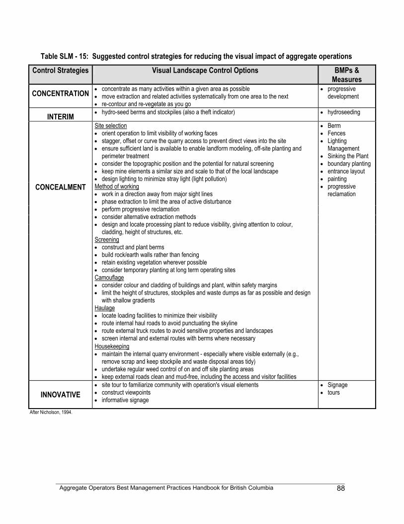
Aggregate Operators Best Management Practices Handbook for British Columbia
88
Table SLM - 15: Suggested control strategies for reducing the visual impact of aggregate operations
Control Strategies Visual Landscape Control Options BMPs & Measures
CONCENTRATION • concentrate as many activities within a given area as possible • move extraction and related activities systematically from one area to the next • re-contour and re-vegetate as you go
• progressive development
INTERIM • hydro-seed berms and stockpiles (also a theft indicator) • hydroseeding
Site selection • orient operation to limit visibility of working faces • stagger, offset or curve the quarry access to prevent direct views into the site • ensure sufficient land is available to enable landform modeling, off-site planting and
perimeter treatment • consider the topographic position and the potential for natural screening • keep mine elements a similar size and scale to that of the local landscape • design lighting to minimize stray light (light pollution)
• Berm • Fences • Lighting
Management • Sinking the Plant • boundary planting • entrance layout • painting
CONCEALMENT • progressive reclamation
Method of working • work in a direction away from major sight lines • phase extraction to limit the area of active disturbance • perform progressive reclamation • consider alternative extraction methods • design and locate processing plant to reduce visibility, giving attention to colour,
cladding, height of structures, etc. Screening • construct and plant berms • build rock/earth walls rather than fencing • retain existing vegetation wherever possible • consider temporary planting at long term operating sites Camouflage • consider colour and cladding of buildings and plant, within safety margins • limit the height of structures, stockpiles and waste dumps as far as possible and design
with shallow gradients Haulage • locate loading facilities to minimize their visibility • route internal haul roads to avoid punctuating the skyline • route external truck routes to avoid sensitive properties and landscapes • screen internal and external routes with berms where necessary Housekeeping • maintain the internal quarry environment - especially where visible externally (e.g.,
remove scrap and keep stockpile and waste disposal areas tidy) • undertake regular weed control of on and off site planting areas • keep external roads clean and mud-free, including the access and visitor facilities
INNOVATIVE
• site tour to familiarize community with operation's visual elements • construct viewpoints • informative signage
• Signage • tours
After Nicholson, 1994.
Aggregate Operators Best Management Practices Handbook for British Columbia
89
5-8 RISK MANAGEMENT MODULE - RMM Sand and gravel pits and rock quarries commonly have activities and equipment that are potentially hazardous. Risks at aggregate operations may affect:
• humans (employees and the public) • the environment • the operation
There are many simple steps that can be taken to identify, reduce or even eliminate risks at aggregate operations, including:
• identifying potential risks • identifying receptors sensitive to risk • planning site layout to minimize risk exposure • planning activities and procedures to minimize risk exposure • planning to communicate risk
This module will define risk and discuss areas where risks can be reduced at aggregate operations. Those areas include:
• emergency and spill response • employee training • identifying potential environmental issues • community relations
Risk types that will not be discussed in this module include:
• contractual • political • investment and general business risks
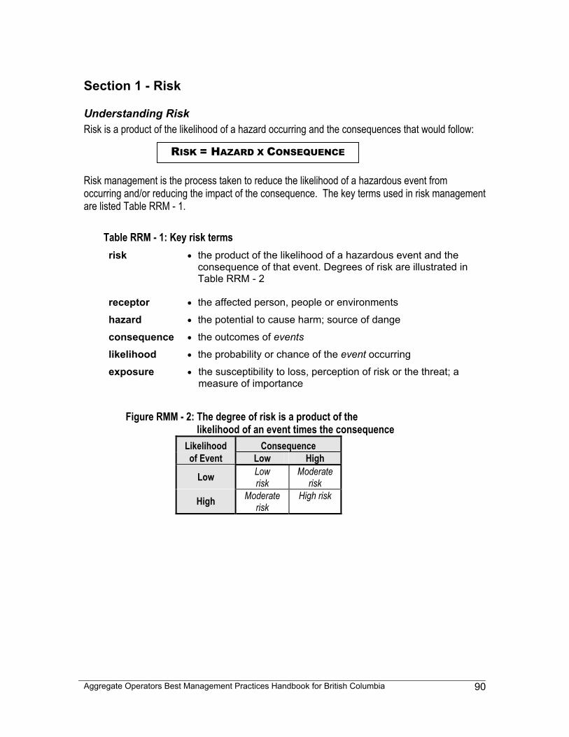
Aggregate Operators Best Management Practices Handbook for British Columbia
90
Section 1 - Risk
Understanding Risk Risk is a product of the likelihood of a hazard occurring and the consequences that would follow: Risk management is the process taken to reduce the likelihood of a hazardous event from occurring and/or reducing the impact of the consequence. The key terms used in risk management are listed Table RRM - 1.
Table RRM - 1: Key risk terms risk • the product of the likelihood of a hazardous event and the
consequence of that event. Degrees of risk are illustrated in Table RRM - 2
receptor • the affected person, people or environments
hazard • the potential to cause harm; source of dange
consequence • the outcomes of events
likelihood • the probability or chance of the event occurring
exposure • the susceptibility to loss, perception of risk or the threat; a measure of importance
Figure RMM - 2: The degree of risk is a product of the likelihood of an event times the consequence
Likelihood Consequence of Event Low High
Low Low risk
Moderate risk
High Moderate risk
High risk
RISK = HAZARD X CONSEQUENCE
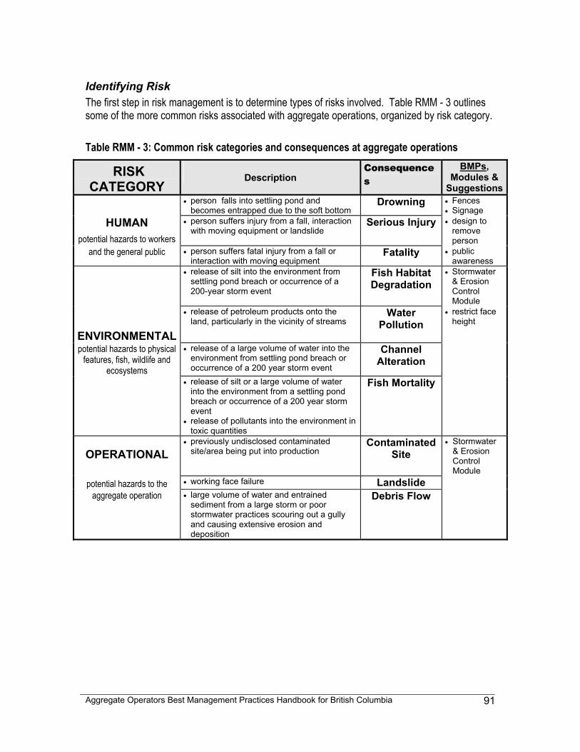
Aggregate Operators Best Management Practices Handbook for British Columbia
91
Identifying Risk The first step in risk management is to determine types of risks involved. Table RMM - 3 outlines some of the more common risks associated with aggregate operations, organized by risk category. Table RMM - 3: Common risk categories and consequences at aggregate operations
RISK CATEGORY Description
Consequences
BMPs, Modules &
Suggestions • person falls into settling pond and
becomes entrapped due to the soft bottom Drowning • Fences
• Signage HUMAN
potential hazards to workers • person suffers injury from a fall, interaction
with moving equipment or landslide Serious Injury • design to
remove person
and the general public • person suffers fatal injury from a fall or interaction with moving equipment
Fatality • public awareness
• release of silt into the environment from settling pond breach or occurrence of a 200-year storm event
Fish Habitat Degradation
• Stormwater & Erosion Control Module
ENVIRONMENTAL
• release of petroleum products onto the land, particularly in the vicinity of streams
Water Pollution
• restrict face height
potential hazards to physical features, fish, wildlife and
ecosystems
• release of a large volume of water into the environment from settling pond breach or occurrence of a 200 year storm event
Channel Alteration
• release of silt or a large volume of water into the environment from a settling pond breach or occurrence of a 200 year storm event
• release of pollutants into the environment in toxic quantities
Fish Mortality
OPERATIONAL • previously undisclosed contaminated
site/area being put into production Contaminated
Site • Stormwater
& Erosion Control Module
potential hazards to the • working face failure Landslide aggregate operation • large volume of water and entrained
sediment from a large storm or poor stormwater practices scouring out a gully and causing extensive erosion and deposition
Debris Flow
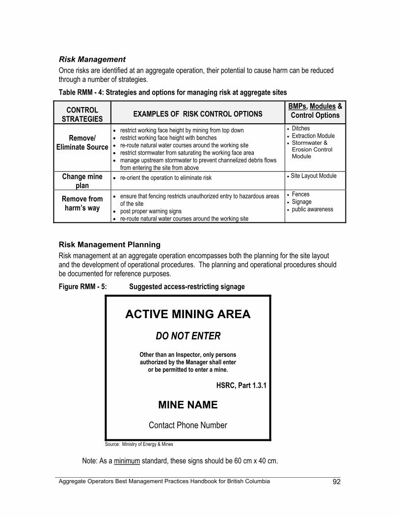
Aggregate Operators Best Management Practices Handbook for British Columbia
92
Risk Management Once risks are identified at an aggregate operation, their potential to cause harm can be reduced through a number of strategies. Table RMM - 4: Strategies and options for managing risk at aggregate sites
CONTROL STRATEGIES EXAMPLES OF RISK CONTROL OPTIONS
BMPs, Modules & Control Options
Remove/
Eliminate Source
• restrict working face height by mining from top down • restrict working face height with benches • re-route natural water courses around the working site • restrict stormwater from saturating the working face area • manage upstream stormwater to prevent channelized debris flows
from entering the site from above
• Ditches • Extraction Module • Stormwater &
Erosion Control Module
Change mine plan
• re-orient the operation to eliminate risk • Site Layout Module
Remove from harm’s way
• ensure that fencing restricts unauthorized entry to hazardous areas of the site
• post proper warning signs • re-route natural water courses around the working site
• Fences • Signage • public awareness
Risk Management Planning Risk management at an aggregate operation encompasses both the planning for the site layout and the development of operational procedures. The planning and operational procedures should be documented for reference purposes. Figure RMM - 5: Suggested access-restricting signage
ACTIVE MINING AREA
DO NOT ENTER
Other than an Inspector, only persons authorized by the Manager shall enter
or be permitted to enter a mine.
HSRC, Part 1.3.1
MINE NAME
Contact Phone Number
Source: Ministry of Energy & Mines
Note: As a minimum standard, these signs should be 60 cm x 40 cm.
Aggregate Operators Best Management Practices Handbook for British Columbia
93
Section 2 - Emergency and Spill Response (ESR)
Emergency and Spill Response All aggregate operations in British Columbia are defined as mines and are therefore required, under the Health, Safety and Reclamation Code 6.13.1(6), to develop, post and regularly update an emergency plan. An emergency plan will help identify and reduce potential risks and help company personnel respond to emergencies and spills in a timely and effective manner, safeguarding people, the environment and the operation. This section of the Risk Management Module will discuss emergency and spill response options that can be considered for integration into the required emergency plan. Topics for consideration for ESR planning may include:
• company information • ESR site map • marshalling area establishment • hazard and hazardous material review (WHMIS) • pollution prevention measures • summary of roles and responsibilities • emergency systems and equipment • emergency response guidelines • listing of emergency telephone numbers • emergency response training • notification and reporting requirements • containment and clean-up techniques/options
Company Information Company information may include any corporate information that could be required during an emergency, such as:
• name • street address, map location • telephone numbers of trained workers and management • security guard company name and telephone number • primary corporate contact names and business, cellular and home phone numbers • list of trained workers
ESR Site Map An ESR site map should include all facilities, structures and roads on the site. It may also include potentially hazardous areas, such as fuel storage tanks, refuelling areas, maintenance areas and the designated marshalling area. As equipment and extraction activities move around the site, their locations on the map should be updated as required. This map can be posted at the marshalling area and at other strategic locations around the site. Laminating the map may be useful, as many printers now use water-soluble ink.
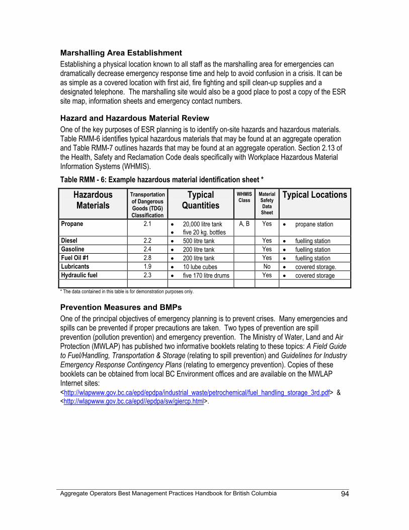
Aggregate Operators Best Management Practices Handbook for British Columbia
94
Marshalling Area Establishment Establishing a physical location known to all staff as the marshalling area for emergencies can dramatically decrease emergency response time and help to avoid confusion in a crisis. It can be as simple as a covered location with first aid, fire fighting and spill clean-up supplies and a designated telephone. The marshalling site would also be a good place to post a copy of the ESR site map, information sheets and emergency contact numbers.
Hazard and Hazardous Material Review One of the key purposes of ESR planning is to identify on-site hazards and hazardous materials. Table RMM-6 identifies typical hazardous materials that may be found at an aggregate operation and Table RMM-7 outlines hazards that may be found at an aggregate operation. Section 2.13 of the Health, Safety and Reclamation Code deals specifically with Workplace Hazardous Material Information Systems (WHMIS). Table RMM - 6: Example hazardous material identification sheet *
Hazardous Materials
Transportation of Dangerous Goods (TDG) Classification
Typical Quantities
WHMIS Class
Material Safety Data
Sheet
Typical Locations
Propane 2.1 • 20,000 litre tank • five 20 kg. bottles
A, B Yes • propane station
Diesel 2.2 • 500 litre tank Yes • fuelling station Gasoline 2.4 • 200 litre tank Yes • fuelling station Fuel Oil #1 2.8 • 200 litre tank Yes • fuelling station Lubricants 1.9 • 10 lube cubes No • covered storage. Hydraulic fuel 2.3 • five 170 litre drums Yes • covered storage * The data contained in this table is for demonstration purposes only.
Prevention Measures and BMPs One of the principal objectives of emergency planning is to prevent crises. Many emergencies and spills can be prevented if proper precautions are taken. Two types of prevention are spill prevention (pollution prevention) and emergency prevention. The Ministry of Water, Land and Air Protection (MWLAP) has published two informative booklets relating to these topics: A Field Guide to Fuel/Handling, Transportation & Storage (relating to spill prevention) and Guidelines for Industry Emergency Response Contingency Plans (relating to emergency prevention). Copies of these booklets can be obtained from local BC Environment offices and are available on the MWLAP Internet sites: <http://wlapwww.gov.bc.ca/epd/epdpa/industrial_waste/petrochemical/fuel_handling_storage_3rd.pdf> & <http://wlapwww.gov.bc.ca/epd//epdpa/sw/giercp.html>.
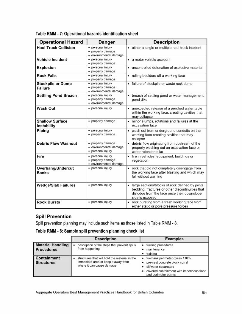
Aggregate Operators Best Management Practices Handbook for British Columbia
95
Table RMM - 7: Operational hazards identification sheet Operational Hazard Danger Description
Haul Truck Collision • personal injury • property damage • environmental damage
• either a single or multiple haul truck incident
Vehicle Incident • personal injury • property damage
• a motor vehicle accident
Explosion • personal injury • property damage
• uncontrolled detonation of explosive material
Rock Falls • personal injury • property damage
• rolling boulders off a working face
Stockpile or Dump Failure
• personal injury • property damage • environmental damage
• failure of stockpile or waste rock dump
Settling Pond Breach • personal injury • property damage • environmental damage
• breach of settling pond or water management pond dike
Wash Out • personal injury • unexpected release of a perched water table
within the working face, creating cavities that may collapse
Shallow Surface Instability
• property damage • minor slumps, rotations and failures at the excavation face
Piping • personal injury • property damage
• wash out from underground conduits on the working face creating cavities that may collapse
Debris Flow Washout • property damage • environmental damage • personal injury
• debris flow originating from upstream of the property washing out an excavation face or water retention dike
Fire • personal injury • property damage • environmental damage
• fire in vehicles, equipment, buildings or vegetation
Overhang/Undercut Banks
• personal injury • rock that did not completely disengage from the working face after blasting and which may fall without warning
Wedge/Slab Failures • personal injury • large sections/blocks of rock defined by joints,
bedding, fractures or other discontinuities that dislodge from the face once their downslope side is exposed
Rock Bursts • personal injury • rock bursting from a fresh working face from either static or pore pressure forces
Spill Prevention Spill prevention planning may include such items as those listed in Table RMM - 8. Table RMM - 8: Sample spill prevention planning check list Description Examples Material Handling Procedures
• description of the steps that prevent spills from happening
• fuelling procedures • maintenance • training
Containment Structures
• structures that will hold the material in the immediate area or keep it away from where it can cause damage
• fuel tank perimeter dykes 110% • pre-cast concrete block corral • oil/water separators • covered containment with impervious floor
and perimeter berms
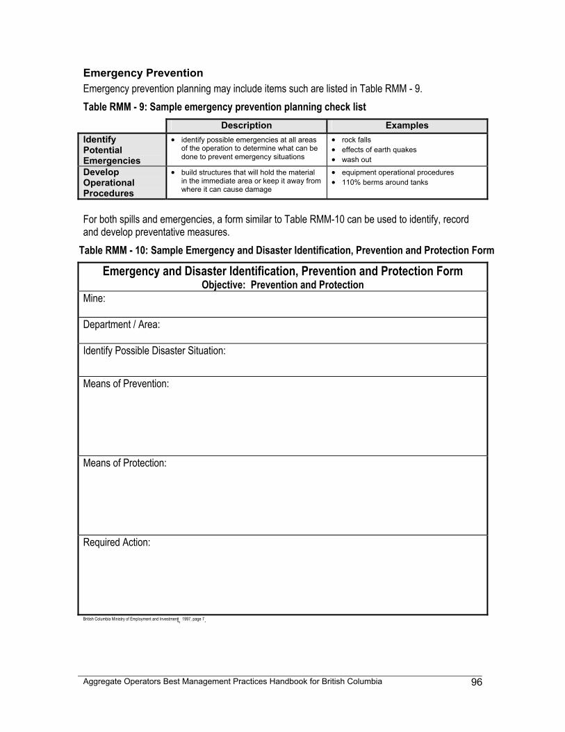
Aggregate Operators Best Management Practices Handbook for British Columbia
96
Emergency Prevention Emergency prevention planning may include items such are listed in Table RMM - 9. Table RMM - 9: Sample emergency prevention planning check list Description Examples Identify Potential Emergencies
• identify possible emergencies at all areas of the operation to determine what can be done to prevent emergency situations
• rock falls • effects of earth quakes • wash out
Develop Operational Procedures
• build structures that will hold the material in the immediate area or keep it away from where it can cause damage
• equipment operational procedures • 110% berms around tanks
For both spills and emergencies, a form similar to Table RMM-10 can be used to identify, record and develop preventative measures.
Table RMM - 10: Sample Emergency and Disaster Identification, Prevention and Protection Form
Emergency and Disaster Identification, Prevention and Protection Form Objective: Prevention and Protection
Mine: Department / Area: Identify Possible Disaster Situation:
Means of Prevention:
Means of Protection:
Required Action:
British Columbia Ministry of Employment and Investment, 1997, page 7.
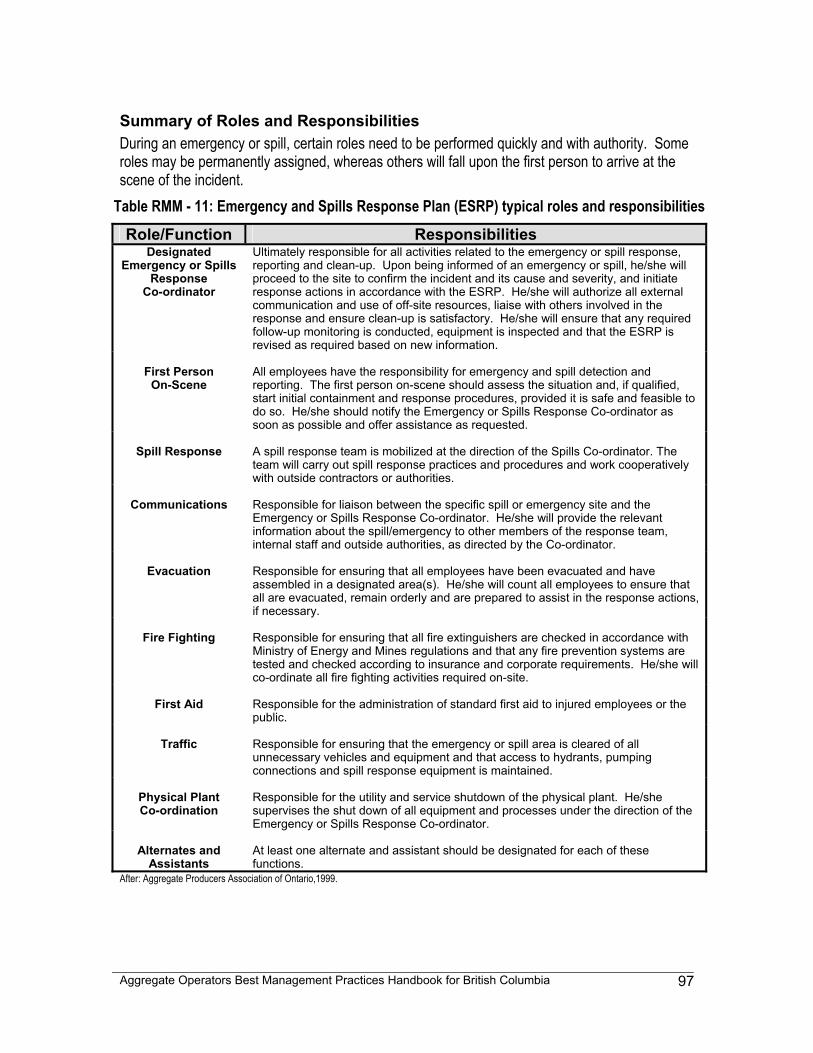
Aggregate Operators Best Management Practices Handbook for British Columbia
97
Summary of Roles and Responsibilities During an emergency or spill, certain roles need to be performed quickly and with authority. Some roles may be permanently assigned, whereas others will fall upon the first person to arrive at the scene of the incident.
Table RMM - 11: Emergency and Spills Response Plan (ESRP) typical roles and responsibilities Role/Function Responsibilities
Designated Emergency or Spills
Response Co-ordinator
Ultimately responsible for all activities related to the emergency or spill response, reporting and clean-up. Upon being informed of an emergency or spill, he/she will proceed to the site to confirm the incident and its cause and severity, and initiate response actions in accordance with the ESRP. He/she will authorize all external communication and use of off-site resources, liaise with others involved in the response and ensure clean-up is satisfactory. He/she will ensure that any required follow-up monitoring is conducted, equipment is inspected and that the ESRP is revised as required based on new information.
First Person
On-Scene
All employees have the responsibility for emergency and spill detection and reporting. The first person on-scene should assess the situation and, if qualified, start initial containment and response procedures, provided it is safe and feasible to do so. He/she should notify the Emergency or Spills Response Co-ordinator as soon as possible and offer assistance as requested.
Spill Response
A spill response team is mobilized at the direction of the Spills Co-ordinator. The team will carry out spill response practices and procedures and work cooperatively with outside contractors or authorities.
Communications
Responsible for liaison between the specific spill or emergency site and the Emergency or Spills Response Co-ordinator. He/she will provide the relevant information about the spill/emergency to other members of the response team, internal staff and outside authorities, as directed by the Co-ordinator.
Evacuation
Responsible for ensuring that all employees have been evacuated and have assembled in a designated area(s). He/she will count all employees to ensure that all are evacuated, remain orderly and are prepared to assist in the response actions, if necessary.
Fire Fighting
Responsible for ensuring that all fire extinguishers are checked in accordance with Ministry of Energy and Mines regulations and that any fire prevention systems are tested and checked according to insurance and corporate requirements. He/she will co-ordinate all fire fighting activities required on-site.
First Aid
Responsible for the administration of standard first aid to injured employees or the public.
Traffic
Responsible for ensuring that the emergency or spill area is cleared of all unnecessary vehicles and equipment and that access to hydrants, pumping connections and spill response equipment is maintained.
Physical Plant Co-ordination
Responsible for the utility and service shutdown of the physical plant. He/she supervises the shut down of all equipment and processes under the direction of the Emergency or Spills Response Co-ordinator.
Alternates and
Assistants
At least one alternate and assistant should be designated for each of these functions.
After: Aggregate Producers Association of Ontario,1999.
Aggregate Operators Best Management Practices Handbook for British Columbia
98
Emergency Systems And Equipment Having the proper equipment on hand to deal with an emergency or disaster can play a large role in mitigating effects. Schedule 2 of the Mine Emergency Response Plan, Guideline for the Mining Industry, published by the British Columbia Ministry of Energy and Mines, has an extensive list of emergency systems and equipment. Some of the equipment categories include: • first aid equipment • fire fighting equipment • vehicle rescue equipment • receding stockpiles/bin equipment • electrical equipment • water rescue equipment • communications equipment • mine rescue equipment Specific spill response equipment may include: • sorbents • oil recovery pumps • drum patch kits • skimmers and booms • water containers • Material Safety Data Sheets (MSDS) Typical locations for emergency systems and equipment could be listed and located on an ESR Site Map. Many mining jurisdictions also encourage neighbouring operations to cooperate by sharing emergency and spill equipment and supplies. Further, an ESR plan should attempt to work with disaster, fire and/or emergency response plans of local, provincial and federal agencies. For example, operators in areas prone to flooding may decide to provide local emergency officials with gate keys for emergency access to sand and rip rap.
Emergency Response Guidelines Emergency response guidelines are a company’s guide to procedures and plans of action. The guidelines will vary depending upon the size and character of the operation, but will have many similarities. Generic steps for emergency response are as follows:
1. identify appropriate levels of response 2. decide on plan of action 3. organize emergency operations 4. recognition, notification, initial response (containment), clean-up, and incident
documentation
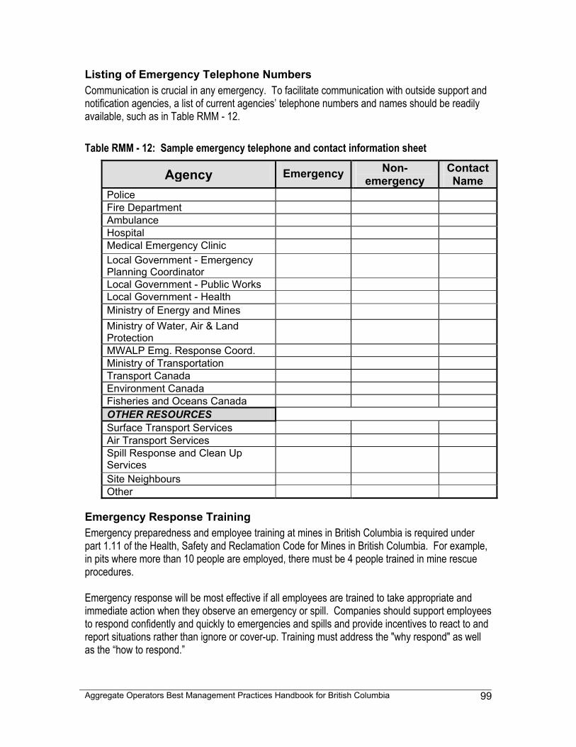
Aggregate Operators Best Management Practices Handbook for British Columbia
99
Listing of Emergency Telephone Numbers Communication is crucial in any emergency. To facilitate communication with outside support and notification agencies, a list of current agencies’ telephone numbers and names should be readily available, such as in Table RMM - 12. Table RMM - 12: Sample emergency telephone and contact information sheet
Agency Emergency Non-emergency
Contact Name
Police Fire Department Ambulance Hospital Medical Emergency Clinic Local Government - Emergency Planning Coordinator
Local Government - Public Works Local Government - Health Ministry of Energy and Mines
Ministry of Water, Air & Land Protection
MWALP Emg. Response Coord. Ministry of Transportation Transport Canada Environment Canada Fisheries and Oceans Canada OTHER RESOURCES Surface Transport Services Air Transport Services Spill Response and Clean Up Services
Site Neighbours Other
Emergency Response Training Emergency preparedness and employee training at mines in British Columbia is required under part 1.11 of the Health, Safety and Reclamation Code for Mines in British Columbia. For example, in pits where more than 10 people are employed, there must be 4 people trained in mine rescue procedures. Emergency response will be most effective if all employees are trained to take appropriate and immediate action when they observe an emergency or spill. Companies should support employees to respond confidently and quickly to emergencies and spills and provide incentives to react to and report situations rather than ignore or cover-up. Training must address the "why respond" as well as the “how to respond.”
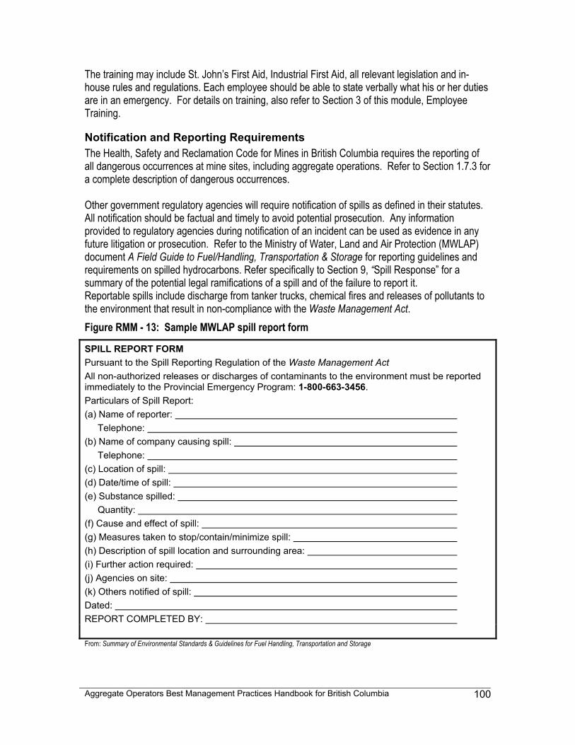
Aggregate Operators Best Management Practices Handbook for British Columbia
100
The training may include St. John’s First Aid, Industrial First Aid, all relevant legislation and in-house rules and regulations. Each employee should be able to state verbally what his or her duties are in an emergency. For details on training, also refer to Section 3 of this module, Employee Training.
Notification and Reporting Requirements The Health, Safety and Reclamation Code for Mines in British Columbia requires the reporting of all dangerous occurrences at mine sites, including aggregate operations. Refer to Section 1.7.3 for a complete description of dangerous occurrences. Other government regulatory agencies will require notification of spills as defined in their statutes. All notification should be factual and timely to avoid potential prosecution. Any information provided to regulatory agencies during notification of an incident can be used as evidence in any future litigation or prosecution. Refer to the Ministry of Water, Land and Air Protection (MWLAP) document A Field Guide to Fuel/Handling, Transportation & Storage for reporting guidelines and requirements on spilled hydrocarbons. Refer specifically to Section 9, “Spill Response” for a summary of the potential legal ramifications of a spill and of the failure to report it. Reportable spills include discharge from tanker trucks, chemical fires and releases of pollutants to the environment that result in non-compliance with the Waste Management Act. Figure RMM - 13: Sample MWLAP spill report form
SPILL REPORT FORM Pursuant to the Spill Reporting Regulation of the Waste Management Act All non-authorized releases or discharges of contaminants to the environment must be reported immediately to the Provincial Emergency Program: 1-800-663-3456. Particulars of Spill Report: (a) Name of reporter: Telephone: (b) Name of company causing spill: Telephone: (c) Location of spill: (d) Date/time of spill: (e) Substance spilled: Quantity: (f) Cause and effect of spill: (g) Measures taken to stop/contain/minimize spill: (h) Description of spill location and surrounding area: (i) Further action required: (j) Agencies on site: (k) Others notified of spill: Dated: REPORT COMPLETED BY: From: Summary of Environmental Standards & Guidelines for Fuel Handling, Transportation and Storage
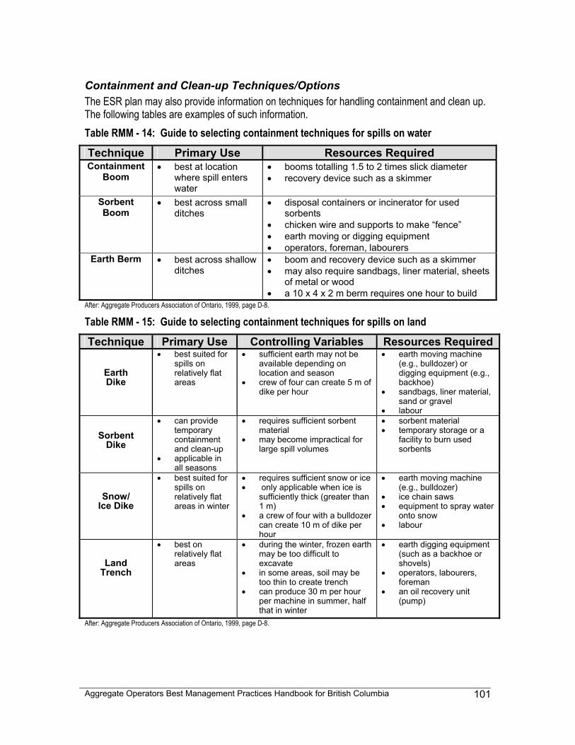
Aggregate Operators Best Management Practices Handbook for British Columbia
101
Containment and Clean-up Techniques/Options The ESR plan may also provide information on techniques for handling containment and clean up. The following tables are examples of such information. Table RMM - 14: Guide to selecting containment techniques for spills on water Technique Primary Use Resources Required Containment
Boom
• best at location where spill enters water
• booms totalling 1.5 to 2 times slick diameter • recovery device such as a skimmer
Sorbent Boom
• best across small ditches
• disposal containers or incinerator for used sorbents
• chicken wire and supports to make “fence” • earth moving or digging equipment • operators, foreman, labourers
Earth Berm • best across shallow ditches
• boom and recovery device such as a skimmer • may also require sandbags, liner material, sheets
of metal or wood • a 10 x 4 x 2 m berm requires one hour to build
After: Aggregate Producers Association of Ontario, 1999, page D-8.
Table RMM - 15: Guide to selecting containment techniques for spills on land Technique Primary Use Controlling Variables Resources Required
Earth Dike
• best suited for spills on relatively flat areas
• sufficient earth may not be available depending on location and season
• crew of four can create 5 m of dike per hour
• earth moving machine (e.g., bulldozer) or digging equipment (e.g., backhoe)
• sandbags, liner material, sand or gravel
• labour
Sorbent Dike
• can provide temporary containment and clean-up
• applicable in all seasons
• requires sufficient sorbent material
• may become impractical for large spill volumes
• sorbent material • temporary storage or a
facility to burn used sorbents
Snow/ Ice Dike
• best suited for spills on relatively flat areas in winter
• requires sufficient snow or ice • only applicable when ice is
sufficiently thick (greater than 1 m)
• a crew of four with a bulldozer can create 10 m of dike per hour
• earth moving machine (e.g., bulldozer)
• ice chain saws • equipment to spray water
onto snow • labour
Land Trench
• best on relatively flat areas
• during the winter, frozen earth may be too difficult to excavate
• in some areas, soil may be too thin to create trench
• can produce 30 m per hour per machine in summer, half that in winter
• earth digging equipment (such as a backhoe or shovels)
• operators, labourers, foreman
• an oil recovery unit (pump)
After: Aggregate Producers Association of Ontario, 1999, page D-8.
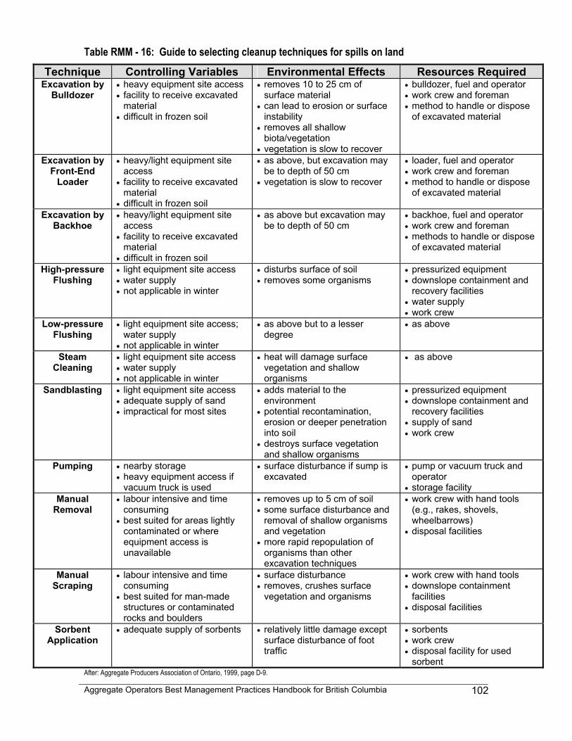
Aggregate Operators Best Management Practices Handbook for British Columbia
102
Table RMM - 16: Guide to selecting cleanup techniques for spills on land Technique Controlling Variables Environmental Effects Resources Required
Excavation by Bulldozer
• heavy equipment site access • facility to receive excavated
material • difficult in frozen soil
• removes 10 to 25 cm of surface material
• can lead to erosion or surface instability
• removes all shallow biota/vegetation
• vegetation is slow to recover
• bulldozer, fuel and operator • work crew and foreman • method to handle or dispose
of excavated material
Excavation by Front-End
Loader
• heavy/light equipment site access
• facility to receive excavated material
• difficult in frozen soil
• as above, but excavation may be to depth of 50 cm
• vegetation is slow to recover
• loader, fuel and operator • work crew and foreman • method to handle or dispose
of excavated material
Excavation by Backhoe
• heavy/light equipment site access
• facility to receive excavated material
• difficult in frozen soil
• as above but excavation may be to depth of 50 cm
• backhoe, fuel and operator • work crew and foreman • methods to handle or dispose
of excavated material
High-pressure Flushing
• light equipment site access • water supply • not applicable in winter
• disturbs surface of soil • removes some organisms
• pressurized equipment • downslope containment and
recovery facilities • water supply • work crew
Low-pressure Flushing
• light equipment site access; water supply
• not applicable in winter
• as above but to a lesser degree
• as above
Steam Cleaning
• light equipment site access • water supply • not applicable in winter
• heat will damage surface vegetation and shallow organisms
• as above
Sandblasting • light equipment site access • adequate supply of sand • impractical for most sites
• adds material to the environment
• potential recontamination, erosion or deeper penetration into soil
• destroys surface vegetation and shallow organisms
• pressurized equipment • downslope containment and
recovery facilities • supply of sand • work crew
Pumping • nearby storage • heavy equipment access if
vacuum truck is used
• surface disturbance if sump is excavated
• pump or vacuum truck and operator
• storage facility Manual
Removal • labour intensive and time
consuming • best suited for areas lightly
contaminated or where equipment access is unavailable
• removes up to 5 cm of soil • some surface disturbance and
removal of shallow organisms and vegetation
• more rapid repopulation of organisms than other excavation techniques
• work crew with hand tools (e.g., rakes, shovels, wheelbarrows)
• disposal facilities
Manual Scraping
• labour intensive and time consuming
• best suited for man-made structures or contaminated rocks and boulders
• surface disturbance • removes, crushes surface
vegetation and organisms
• work crew with hand tools • downslope containment
facilities • disposal facilities
Sorbent Application
• adequate supply of sorbents • relatively little damage except surface disturbance of foot traffic
• sorbents • work crew • disposal facility for used
sorbent After: Aggregate Producers Association of Ontario, 1999, page D-9.
Aggregate Operators Best Management Practices Handbook for British Columbia
103
Section 3 - Employee Training All aggregate operations have inherent operational, safety and environmental risks and concerns. An established training plan can help ensure that critical knowledge is available to both new and experiences employees. A training plan can also provide a structure for performance evaluation, specific task training and refresher training. Historically, training development costs have deterred many smaller operations from implementing training programs. Recently, many training courses have become available at reduced fees, or in some cases, for no fee at all. Thus now the largest cost associated with training is employee time. Operators are advised to contact their industry association for advice on training options.
General Training Considerations
Basic Training Program Planning for employee training should define the knowledge and skills required for the various tasks that are performed at the operation, with emphasis on safety, health and environmental issues. The Health, Safety and Reclamation Code for Mines in British Columbia states that the mine manager shall ensure that workers are adequately trained to do their job or are working under the guidance of someone who has competency both in the job and in giving instructions. Employee training planning should also identify:
• how employees will receive training, • whether there will be written material, • whether the employees receive verbal instructions or view videos, • when new employees will receive training, • when existing employees will receive refresher courses, and • whether employee training will include an assessment of training effectiveness.
Compliance with Permit Conditions Permit compliance depends directly on the competence of the employees who operate the loaders, crushers and haul trucks that transform the raw material into finished product. The mine manager is required to establish and maintain, to the satisfaction of the Chief Inspector of Mines, training programs for those employees and should ensure that:
1) all employees receive thorough orientation and basic instruction in safe work practices, 2) workers have been suitably trained and certified, if required, to safely perform any work to
which they are assigned, and 3) workers know the permit conditions that apply to their work.
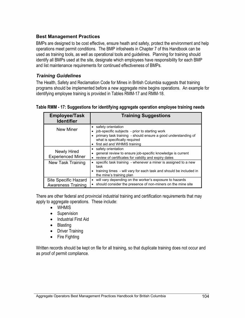
Aggregate Operators Best Management Practices Handbook for British Columbia
104
Best Management Practices BMPs are designed to be cost effective, ensure heath and safety, protect the environment and help operations meet permit conditions. The BMP infosheets in Chapter 7 of this Handbook can be used as training tools, as well as operational tools and guidelines. Planning for training should identify all BMPs used at the site, designate which employees have responsibility for each BMP and list maintenance requirements for continued effectiveness of BMPs.
Training Guidelines The Health, Safety and Reclamation Code for Mines in British Columbia suggests that training programs should be implemented before a new aggregate mine begins operations. An example for identifying employee training is provided in Tables RMM-17 and RMM-18. Table RMM - 17: Suggestions for identifying aggregate operation employee training needs
Employee/Task Identifier
Training Suggestions
New Miner • safety orientation • job-specific subjects - prior to starting work • primary task training - should ensure a good understanding of
what is specifically required • first aid and WHMIS training
Newly Hired Experienced Miner
• safety orientation • general review to ensure job-specific knowledge is current • review of certificates for validity and expiry dates
New Task Training • specific task training - whenever a miner is assigned to a new task
• training times - will vary for each task and should be included in the mine’s training plan
Site Specific Hazard Awareness Training
• will vary depending on the worker’s exposure to hazards • should consider the presence of non-miners on the mine site
There are other federal and provincial industrial training and certification requirements that may apply to aggregate operations. These include:
• WHMIS • Supervision • Industrial First Aid • Blasting • Driver Training • Fire Fighting
Written records should be kept on file for all training, so that duplicate training does not occur and as proof of permit compliance.
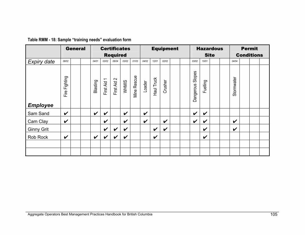
Aggregate Operators Best Management Practices Handbook for British Columbia
105
Table RMM - 18: Sample “training needs” evaluation form
General
Certificates Required
Equipment Hazardous Site
Permit Conditions
Expiry date 08/02 04/01 03/02 06/04 03/02 01/03 04/02 12/01 02/02 03/02 10/01 04/04
Employee
Fire F
ightin
g
Blas
ting
First
Aid 1
First
Aid 2
WHM
IS
Mine
Res
cue
Load
er
Haul
Truc
k
Crus
her
Dang
erou
s Slop
es
Fuell
ing
Stor
mwate
r
Sam Sand ✔ ✔ ✔ ✔ ✔ ✔ ✔
Cam Clay ✔ ✔ ✔ ✔ ✔ ✔ ✔ ✔
Ginny Grit ✔ ✔ ✔ ✔ ✔ ✔ ✔
Rob Rock ✔ ✔ ✔ ✔ ✔ ✔ ✔
Aggregate Operators Best Management Practices Handbook for British Columbia
106
Section 4 - Identifying Potential Environmental Risks To reduce risks of harm to the environment during development, local environmental features should be considered during the planning phase. Potential local issues would include the presence of rare ecosystems, wildlife trees, and "red" or "blue" listed animals or fish. This section of the Risk Management Module will assist aggregate operators in making these determinations during the planning, operation and reclamation of an aggregate site. After reviewing information sources, consultation with the agency responsible for a potentially sensitive environmental feature should be sought. Accounting for these features early in the mine development planning stage reduces potential environmental risks and may make the project more viable or at least decrease the resources necessary to account for the sensitive feature once operations begin.
What Are Identified Environmental Features Identified environmental features are any endangered plants, fish, birds, mammals, trees, ecosystems or wildlife that have been documented by scientific authorities. The main source for this type of information is the British Columbia Conservation Data Centre (CDC), which collects and disseminates information on many rare and endangered plants, animals and plant communities in British Columbia. In addition, some local governments have Environmentally Sensitive Areas Atlases, which identify local features such as streams, wetlands, coastlines, areas of rare vegetation, older forests, riparian vegetation and woodlands. The CDC information is compiled and maintained in a computerized database that provides a centralized source of information on the status, locations and level of protection for these rare organisms and ecosystems. The CDC is part of the Conservation Biology Section of the Resources Inventory Branch, in the Ministry of Sustainable Resource Management. A Natural Features Map for the operation and surrounding area is a good place to start recording potential environmental risks for an aggregate operation. This map could be a paper copy of one of the Federal 1:50,000 National Topographic System (NTS) maps or the newer 1:20,000 Provincial Terrain Resource Information Management (TRIM) maps. Information for ordering TRIM maps is provided in Table RMM - 19. Table RMM - 19: Sources for ordering TRIM maps
• Map Dealer List of Local Agents • Government Agents http://home.gdbc.gov.bc.ca/catalog/govt_agent.htm • TRIM Hardcopy Map Agents http://home.gdbc.gov.bc.ca/catalog/gdbc_map.htm • Nanaimo Maps 1-800-665-2513 or Ordered Over the Internet: • Geographic Data British Columbia http://home.gdbc.gov.bc.ca/
These maps show streams and wetlands, key areas for wildlife. The fact that a stream does not flow all year does not discount it from being habitat for various species. Numerous agencies such
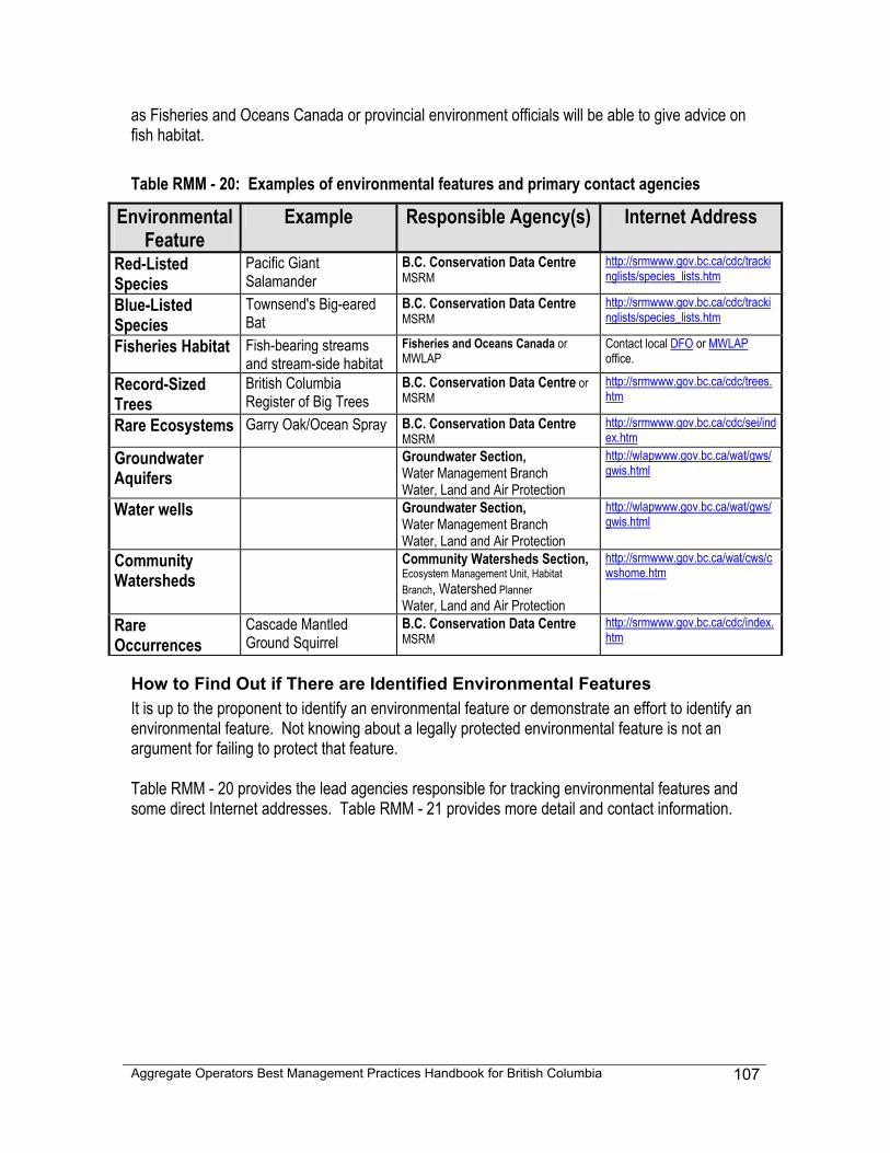
Aggregate Operators Best Management Practices Handbook for British Columbia
107
as Fisheries and Oceans Canada or provincial environment officials will be able to give advice on fish habitat. Table RMM - 20: Examples of environmental features and primary contact agencies
Environmental Feature
Example Responsible Agency(s)
Internet Address
Red-Listed Species
Pacific Giant Salamander
B.C. Conservation Data Centre MSRM
http://srmwww.gov.bc.ca/cdc/trackinglists/species_lists.htm
Blue-Listed Species
Townsend's Big-eared Bat
B.C. Conservation Data Centre MSRM
http://srmwww.gov.bc.ca/cdc/trackinglists/species_lists.htm
Fisheries Habitat Fish-bearing streams and stream-side habitat
Fisheries and Oceans Canada or MWLAP
Contact local DFO or MWLAP office.
Record-Sized Trees
British Columbia Register of Big Trees
B.C. Conservation Data Centre or MSRM
http://srmwww.gov.bc.ca/cdc/trees.htm
Rare Ecosystems Garry Oak/Ocean Spray B.C. Conservation Data Centre MSRM
http://srmwww.gov.bc.ca/cdc/sei/index.htm
Groundwater Aquifers
Groundwater Section, Water Management Branch Water, Land and Air Protection
http://wlapwww.gov.bc.ca/wat/gws/gwis.html
Water wells Groundwater Section, Water Management Branch Water, Land and Air Protection
http://wlapwww.gov.bc.ca/wat/gws/gwis.html
Community Watersheds
Community Watersheds Section, Ecosystem Management Unit, Habitat Branch, Watershed Planner Water, Land and Air Protection
http://srmwww.gov.bc.ca/wat/cws/cwshome.htm
Rare Occurrences
Cascade Mantled Ground Squirrel
B.C. Conservation Data Centre MSRM
http://srmwww.gov.bc.ca/cdc/index.htm
How to Find Out if There are Identified Environmental Features It is up to the proponent to identify an environmental feature or demonstrate an effort to identify an environmental feature. Not knowing about a legally protected environmental feature is not an argument for failing to protect that feature. Table RMM - 20 provides the lead agencies responsible for tracking environmental features and some direct Internet addresses. Table RMM - 21 provides more detail and contact information.
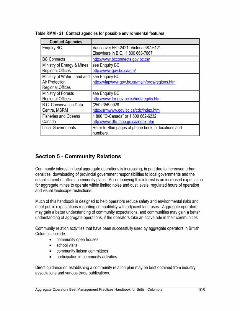
Aggregate Operators Best Management Practices Handbook for British Columbia
108
Table RMM - 21: Contact agencies for possible environmental features
Contact Agencies Enquiry BC Vancouver 660-2421; Victoria 387-6121
Elsewhere in B.C. 1 800 663-7867 BC Connects http://www.bcconnects.gov.bc.ca/ Ministry of Energy & Mines Regional Offices
see Enquiry BC http://www.gov.bc.ca/em/
Ministry of Water, Land and Air Protection Regional Offices
see Enquiry BC http://wlapwww.gov.bc.ca/main/prgs/regions.htm
Ministry of Forests Regional Offices
see Enquiry BC http://www.for.gov.bc.ca/mof/regdis.htm
B.C. Conservation Data Centre, MSRM
(250) 356-0928 http://srmwww.gov.bc.ca/cdc/index.htm
Fisheries and Oceans Canada
1 800 ”O-Canada” or 1 800 662-6232 http://www.dfo-mpo.gc.ca/index.htm
Local Governments Refer to Blue pages of phone book for locations and numbers.
Section 5 - Community Relations Community interest in local aggregate operations is increasing, in part due to increased urban densities, downloading of provincial government responsibilities to local governments and the establishment of official community plans. Accompanying this interest is an increased expectation for aggregate mines to operate within limited noise and dust levels, regulated hours of operation and visual landscape restrictions. Much of this handbook is designed to help operators reduce safety and environmental risks and meet public expectations regarding compatibility with adjacent land uses. Aggregate operators may gain a better understanding of community expectations, and communities may gain a better understanding of aggregate operations, if the operators take an active role in their communities. Community relation activities that have been successfully used by aggregate operators in British Columbia include:
• community open houses • school visits • community liaison committees • participation in community activities
Direct guidance on establishing a community relation plan may be best obtained from industry associations and various trade publications.
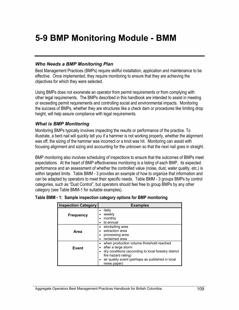
Aggregate Operators Best Management Practices Handbook for British Columbia
109
5-9 BMP Monitoring Module - BMM
Who Needs a BMP Monitoring Plan Best Management Practices (BMPs) require skillful installation, application and maintenance to be effective. Once implemented, they require monitoring to ensure that they are achieving the objectives for which they were selected. Using BMPs does not exonerate an operator from permit requirements or from complying with other legal requirements. The BMPs described in this handbook are intended to assist in meeting or exceeding permit requirements and controlling social and environmental impacts. Monitoring the success of BMPs, whether they are structures like a check dam or procedures like limiting drop height, will help assure compliance with legal requirements.
What is BMP Monitoring Monitoring BMPs typically involves inspecting the results or performance of the practice. To illustrate, a bent nail will quickly tell you if a hammer is not working properly, whether the alignment was off, the sizing of the hammer was incorrect or a knot was hit. Monitoring can assist with focusing alignment and sizing and accounting for the unknown so that the next nail goes in straight. BMP monitoring also involves scheduling of inspections to ensure that the outcomes of BMPs meet expectations. At the heart of BMP effectiveness monitoring is a listing of each BMP, its expected performance and an assessment of whether the controlled value (noise, dust, water quality, etc.) is within targeted limits. Table BMM - 3 provides an example of how to organize that information and can be adapted by operators to meet their specific needs. Table BMM - 3 groups BMPs by control categories, such as “Dust Control”, but operators should feel free to group BMPs by any other category (see Table BMM-1 for suitable examples). Table BMM - 1: Sample inspection category options for BMP monitoring
Inspection Category Examples
Frequency • daily • weekly • monthly • bi-annual
Area • stockpiling area • extraction area • processing area • reclaimed area
Event • when production volume threshold reached • after a large storm • dry conditions (according to local forestry district
fire hazard rating) • air quality event (perhaps as published in local
news paper)
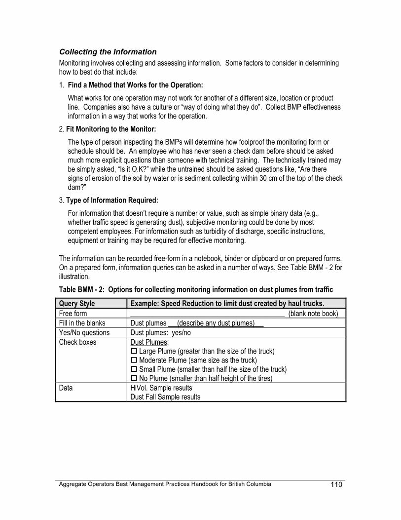
Aggregate Operators Best Management Practices Handbook for British Columbia
110
Collecting the Information Monitoring involves collecting and assessing information. Some factors to consider in determining how to best do that include: 1. Find a Method that Works for the Operation:
What works for one operation may not work for another of a different size, location or product line. Companies also have a culture or “way of doing what they do”. Collect BMP effectiveness information in a way that works for the operation.
2. Fit Monitoring to the Monitor: The type of person inspecting the BMPs will determine how foolproof the monitoring form or schedule should be. An employee who has never seen a check dam before should be asked much more explicit questions than someone with technical training. The technically trained may be simply asked, “Is it O.K?” while the untrained should be asked questions like, “Are there signs of erosion of the soil by water or is sediment collecting within 30 cm of the top of the check dam?”
3. Type of Information Required: For information that doesn’t require a number or value, such as simple binary data (e.g., whether traffic speed is generating dust), subjective monitoring could be done by most competent employees. For information such as turbidity of discharge, specific instructions, equipment or training may be required for effective monitoring.
The information can be recorded free-form in a notebook, binder or clipboard or on prepared forms. On a prepared form, information queries can be asked in a number of ways. See Table BMM - 2 for illustration. Table BMM - 2: Options for collecting monitoring information on dust plumes from traffic
Query Style Example: Speed Reduction to limit dust created by haul trucks. Free form ___________________________________________ (blank note book) Fill in the blanks Dust plumes (describe any dust plumes) Yes/No questions Dust plumes: yes/no Check boxes Dust Plumes:
Large Plume (greater than the size of the truck) Moderate Plume (same size as the truck) Small Plume (smaller than half the size of the truck) No Plume (smaller than half height of the tires)
Data HiVol. Sample results Dust Fall Sample results
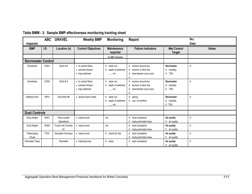
Aggregate Operators Best Management Practices Handbook for British Columbia
111
Table BMM - 3: Sample BMP effectiveness monitoring tracking sheet ABC GRAVEL Weekly BMP Monitoring Report No.:
Inspector Date: BMP I.D. Location (s) Control Objectives Maintenance
required Failure indicators Met Control
Target Notes
ref. BMP 4 Schedule
Stormwater Control Checkdam CD01 Ditch # 8 • to control flows
• prevent erosion • trap sediment
ß clean out ß depth of sediment
___ cm.
ß erosion around top ß erosion in ditch line ß downstream scour pool ß
Stormwater ß turbidity, ß TSS
ß
Checkdam CD02 Ditch # 4 • to control flows • prevent erosion • trap sediment
ß clean out ß depth of sediment
___ cm.
ß erosion around top ß erosion in ditch line ß downstream scour pool ß
Stormwater ß turbidity, ß TSS
ß
Settling Pond SP01 End Ditch #8 • decant storm water ß clean out ß depth of sediment
___ cm.
ß piping ß use of overflow
Stormwater ß turbidity, ß TSS
ß
Dust Controls Drop Height DH01 Face Loader
Operations • reduce dust n/a ß dust complaints
ß dusty perimeter trees Air quality ß air quality
ß
Drop Height DH02 Trucks into Crusher #1
• reduce dust n/a ß dust complaints ß dusty perimeter trees
Air quality ß air quality
ß
Telescoping Chute
TC01 Stockpile Conveyor • reduce dust ß check for rips ß dust complaints ß dusty perimeter trees
Air quality ß air quality
ß
Perimeter Trees Perimeter • intercept dust ß clean ß dust complaints Air quality ß air quality
ß
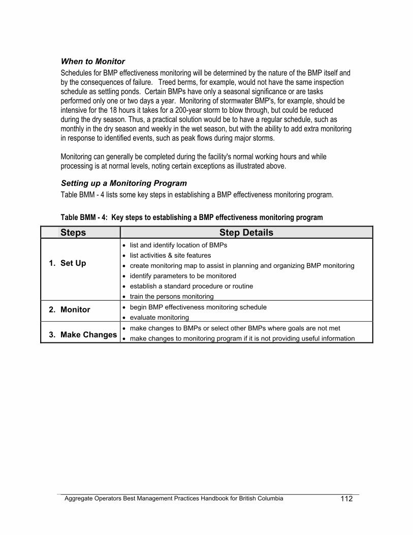
Aggregate Operators Best Management Practices Handbook for British Columbia
112
When to Monitor Schedules for BMP effectiveness monitoring will be determined by the nature of the BMP itself and by the consequences of failure. Treed berms, for example, would not have the same inspection schedule as settling ponds. Certain BMPs have only a seasonal significance or are tasks performed only one or two days a year. Monitoring of stormwater BMP's, for example, should be intensive for the 18 hours it takes for a 200-year storm to blow through, but could be reduced during the dry season. Thus, a practical solution would be to have a regular schedule, such as monthly in the dry season and weekly in the wet season, but with the ability to add extra monitoring in response to identified events, such as peak flows during major storms. Monitoring can generally be completed during the facility's normal working hours and while processing is at normal levels, noting certain exceptions as illustrated above.
Setting up a Monitoring Program Table BMM - 4 lists some key steps in establishing a BMP effectiveness monitoring program. Table BMM - 4: Key steps to establishing a BMP effectiveness monitoring program
Steps Step Details
1.
Set Up
• list and identify location of BMPs • list activities & site features • create monitoring map to assist in planning and organizing BMP monitoring • identify parameters to be monitored • establish a standard procedure or routine • train the persons monitoring
2. Monitor • begin BMP effectiveness monitoring schedule • evaluate monitoring
3. Make Changes • make changes to BMPs or select other BMPs where goals are not met • make changes to monitoring program if it is not providing useful information
Aggregate Operators Best Management Practices Handbook for British Columbia
113
Chapter 6
Reclamation The focus of this handbook is on the planning and operation of sand and gravel pits and rock quarries. A survey of relevant documents, conducted before the writing of this handbook, indicated that numerous aggregate operation reclamation handbooks are currently available and that further reclamation advice is not needed. The key reclamation advice that this handbook provides is: • Extraction is a Temporary Activity - As temporary occupiers of the land, aggregate
operations should conduct their business in such a manner as to not limit post-extraction land uses. Sites where no development will occur should be returned to their natural state with an equal or enhanced ability to grow trees or other forms of vegetation. For development areas, community and environmental stewardship should be included in the planning and operational stages of the pit or quarry.
• Know the End Land Use - In some circumstances, a specific end land use can be determined and may be defined during the permitting process. For operations that have a life span of more than twenty years, general assumptions can be made to help address uncertainty. If local government has zoned the property, that zoning may define the range of permitted post-mining activities.
• Plan For Reclamation - Whatever the level of certainty regarding end land use, an operator should plan for reclamation. This planning can reduce costs by decreasing double handling and the need for material storage areas. Furthermore, early re-vegetation of post-extraction areas reduces dust, visual impacts and stormwater concerns.
• Account for Grade - A flat uniform deposit on level ground may be reclaimed by any number
of strategies, whereas a steep mixed grade hillside deposit will have limited reclamation options. Even if a form of progressive reclamation is possible, it may be years until sufficient working space has been developed to allow reclamation to begin.
Reclamation Strategies The choice between reclamation strategies may be dependent upon:
• the scale of the operation • the geometry of the deposit • the surface geometry • the grade distribution of the deposit
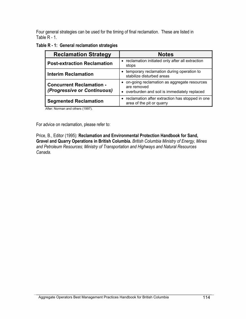
Aggregate Operators Best Management Practices Handbook for British Columbia
114
Four general strategies can be used for the timing of final reclamation. These are listed in Table R - 1. Table R - 1: General reclamation strategies
Reclamation Strategy Notes Post-extraction Reclamation • reclamation initiated only after all extraction
stops
Interim Reclamation • temporary reclamation during operation to stabilize disturbed areas
Concurrent Reclamation - (Progressive or Continuous)
• on-going reclamation as aggregate resources are removed
• overburden and soil is immediately replaced
Segmented Reclamation • reclamation after extraction has stopped in one area of the pit or quarry
After: Norman and others (1997). For advice on reclamation, please refer to: Price, B., Editor (1995): Reclamation and Environmental Protection Handbook for Sand, Gravel and Quarry Operations in British Columbia. British Columbia Ministry of Energy, Mines and Petroleum Resources; Ministry of Transportation and Highways and Natural Resources Canada.
Aggregate Operators Best Management Practices Handbook for British Columbia
115
Chapter 7
Best Management Practices
Introduction This chapter of the handbook presents thirty-seven Best Management Practices (BMPs). The BMPs have been selected for specific application in aggregate operations. There are, however, many "general reference" BMPs that can also be useful. Three recommended websites are:
1. Water Related BMP's in the Landscape. Watershed Science Institute. URL <http://www.abe.msstate.edu/csd/NRCS-BMPs/>, October 2001
2. Best Management Practices for Reclaiming Surface Mines in Washington and Oregon. URL <http://www.wa.gov/dnr/htdocs/ger/pdf/bmp.pdf> [PDF, 7.6 Mb], June 2001, and
3. Stormwater Management Manual for Western Washington, Volumes I-5 Washington State
Department of Ecology, URL <http://www.ecy.wa.gov/biblio/9911.html>, June 2001 (scroll to the bottom of the page for links to volume 2-5).
Also see the "Additional BMP Websites" section at the end of this introduction.
How to Choose BMPs There are three ways to select a BMP from this handbook:
1. Refer to Table 7-1 and 7-2 BMP Module Reference Charts. In these charts, BMPs are cross-referenced against Module topics (extraction, traffic, etc.). Table 7-1 organizes the BMP's into five thematic groupings (Stormwater Mangagement, Erosion Control, Noise and Dust, Risk Management and Pollution Prevention), while Table 7-2 lists them alphabetically.
2. Review Topical Modules for Suggestions Tables within the Chapter 5 modules suggest specific BMPs to address specific problems.
3. Flip Through the BMPs in Chapter 7 The BMPs in Chapter 7 all have a "USE" box in the upper right hand corner of the first page. They can be selected by simply looking for a "USE" box with an appropriate application.
Aggregate Operators Best Management Practices Handbook for British Columbia
116
Additional BMP Websites
British Columbia Ministry of Water, Land and Air Protection. (2001): Environmental Objectives, Best Management Practices and Requirements for Land Developments. BC Environment, Vancouver Island Region, URL <http://wlapwww.gov.bc.ca/vir/pa/bmp_dev1.htm>, October 2001.
British Columbia Ministry of Water, Land and Air Protection. (2001): Best Management Practices To Protect Water Quality. Water Quality Branch, URL < http://wlapwww.gov.bc.ca/wat/wq/NPS_web_page/BMP_Compendium/BMP_Introduction/BMP_Home.htm >, October 2001.
Chilibeck, B., Chislett, G. and Norris, G. (1992): Land Development Guidelines for the Protection of Aquatic Habitat; Department of Fisheries and Oceans, and Ministry of Environment, Lands and Parks, URL <http://www-heb.pac.dfo-mpo.gc.ca/english/publications/PDF/guidelines/ldg.PDF> [PDF, 1.5 Mb], June 2001.
Ciuba, S. and Austin, L. (2001): Runoff Treatment BMPs; in Stormwater Management Manual for Western Washington, Volume V; Washington State Department of Ecology, Publication 9915, URL <http://www.ecy.wa.gov/biblio/9915.html>, June 2001.
Cole, L., Smith, P., Wright, J. and Clough, R. (1999): Controlling the Environmental Effects of Recycled and Secondary Production Good Practice Guidance; United Kingdom Department of the Environment, Transportation and the Regions, URL <http://www.planning.detr.gov.uk/recycled/practice/index.htm>, June 2001.
Coulter, T.S. and Halladay, D.R. (1997): Manual of Control of Erosion and Shallow Slope Movement; Ministry of Transportation and Highways, Vancouver Island Highway Project.
Field, L.Y. and Engel, B.A. Best Management Practices for Soil Erosion; Purdue University, Agricultural and Biological Engineering Department, URL <http://pasture.ecn.purdue.edu/AGEN521/epadir/erosion/asm521.html>, October 2001.
Norman, D.K., Wampler, P.J., Throop, A.H., Schnitzer, E.F. and Roloff, J.M. (1997): Best Management Practices for Reclaiming Surface Mines in Washington and Oregon; Washington State Department of Natural Resources Open File Report 96-2 and Oregon Department of Geology and Mineral Industries Open File Report O-96-2, 128 pages, URL <http://www.wa.gov/dnr/htdocs/ger/pdf/bmp.pdf> [PDF, 7.6 Mb], June 2001.
O'Brien, E. (2001): Minimum Technical Requirements; Stormwater Management Manual for Western Washington, Volume I. Washington State Department of Ecology, Publication 9911, URL <http://www.ecy.wa.gov/biblio/9911.html>, June 2001.
Thomas, M., Editor (2000): Controlling and Mitigating the Environmental Effects of Minerals Extraction in England Consultation Paper; Mineral Planning Guidance Note 11. United Kingdom Department of the Environment, Transportation and the Regions, URL <http://www.planning.detr.gov.uk/consult/mpg11/index.htm>, June 2001.
United States Department of Agriculture and Mississippi State University. (1999): Water Related BMP's in the Landscape; Watershed Science Institute. Created for the Natural Resource Conservation Service, United States Department of Agriculture by the Center for Sustainable

Aggregate Operators Best Management Practices Handbook for British Columbia
117
Design Mississippi State University Departments of Landscape Architecture, Agricultural and Biological Engineering, and the College of Agriculture and Life Sciences, URL <http://www.abe.msstate.edu/scd/NRSC-BMPs/index.html>, October 2001.
Aggregate Operators Best Management Practices Handbook for British Columbia
118
Appendix 1 - AGGREGATE GEOLOGY Note: definitions are specific to aggregate operations or are operational definitions used in the aggregate industry.
aggregate Sand, gravel, crushed stone and quarried rock used for construction purposes.
ambient water quality
Water in its natural state; the existing environmental condition of the water or how it was found.
aquifer A layer of gravel, sand or porous, fractured rock containing saturated permeable material through which significant amounts of ground water can travel to wells and springs.
as-built drawings Engineering plans that have been revised to reflect all changes to the plans that occurred during construction.
as-graded The configuration of the surface conditions on completion of grading.
average monthly discharge
The average of the measured turbidity or other water quality values (TSS, TDS, etc.) collected from a discharge point over a calendar month's time. For further water quality information related to the environment, contact the local office of the Ministry of Water, Land and Air Protection. For information related to discharge and drinking water, contact the local office of the Regional Health Authority.
baffles Partitions within a settling pond or retention basin designed to increase the length the water travels before discharge.
bedrock The solid rock that underlies the soil, overburden and unconsolidated material.
bench A relatively level or back sloping step, excavated or constructed on the face of a graded slope surface for safety, stability, drainage and to facilitate maintenance.
berm A constructed barrier of overburden, topsoil or waste rock, often planted with trees, shrubs and ground cover. Berms are used to block noise, dust and views of an aggregate operation from reaching adjacent properties.
best management practices (BMP)
BMPs can be physical structures, activities, practices or procedures that prevent, reduce or mitigate an undesired event, impact or effect.
biodiversity The variety and variability among living organisms and the ecological complexes in which they occur.
bioengineering Restoration or reinforcement of slopes and stream banks with living plant materials.
biophysics The study of the biological and physical characteristics of an area (e.g., topography, soils, climate, landforms, watercourses, vegetation, etc.).
blue-listed species
Vulnerable indigenous species or sub species (refer to endangered species).
borrow pit An excavation to provide fill for construction activities.
buffer strip A strip of land that separates incompatible activities. Buffer strips can be used to intercept dust and noise, enhance aesthetics or other qualities along or adjacent to residences, roads and trails, filter stormwater runoff or protect an environmentally sensitive area such as a stream (riparian area). They may be land left in its natural state or planted to perform specific objectives.
clearing The removal of trees and shrubs.
coir fascines Although "coir" is actually made from coconut husks, this term has been adopted in BC to mean a mat or bundle made from willow whips, branches or cuttings for such uses as filling ditches or making revetments on unstable slopes or banks.
Aggregate Operators Best Management Practices Handbook for British Columbia
119
competency A measure of the strength or soundness of rock.
community values
Consensus, expectations and opinions of a local population.
crushed stone Rock, boulders and cobbles that are blasted or mined and subsequently crushed and processed into aggregate.
deleterious Harmful to health or well-being.
deposit characteristics
Physical properties, sedimentary features, quality, particle gradation and composition of a deposit.
deposit model A planning model that includes the geological feature that makes up the sand and gravel (e.g., Delta, alluvial terrace, outwash plain, drumlin), the deposit characteristic (e.g., rock types, rock characteristics), the deposit size (e.g., surface area, depth) and environmental effects of mining (e.g., high clay content).
deposit size Surface area, thickness and volume of gravel.
ditch grade control
The action of controlling the steepness of a channel, ditch or any watercourse. Grades of less than 5 percent are generally desirable for watercourses to avoid erosion. Check Dams are commonly used to control grades in ditches.
effluent Waste material released either into the air or water, or onto land.
endangered species
Species and ecosystems at risk in British Columbia number in the hundreds. The identified species and ecosystems are tracked and ranked by the BC Conservation Data Centre (CDC). The ranking assists the Ministry of Sustainable Resource Management in assigning them a red or blue listed status.
The red listing means that the listed species are, or are close to being extirpated, endangered or threatened. Extirpated means they no longer exist in the wild in B.C., but do occur elsewhere. Endangered means they are facing imminent extirpation or extinction. Threatened means that they are likely to become endangered if limiting factors are not reversed.
The blue list includes vulnerable indigenous species or subspecies that are of special concern because of characteristics that make them particularly sensitive to human activities or natural events. It also includes species that are generally suspected of being vulnerable, but for which information is too limited to allow designation in another category.
erosion The wearing away of the ground surface as the result of wind, running water, ice or other geological agents, including such processes as gravitational creep.
erosion and sediment control
Procedures intended to prevent erosion and sedimentation, such as preserving natural vegetation, seeding, mulching and matting, plastic covering, filter fences, and sediment traps and ponds.
extraction The process of removing raw material, rock or aggregate from the deposit location.
face See mining face.
fishery An area of water that is being fished. A fishery includes the full area from which fish may be taken by a pound, seine, net, weir or other fishing appliance, and the appliance itself.
flocculation The process by which suspended or very fine particles in water are assembled into larger masses or floccules that eventually settle out of suspension. This process occurs naturally, but can also be accelerated through the use of chemicals such as alum.
fugitive dust Dust which is generated by unstable, non-point sources like movement of equipment and the effects of wind and rain on stockpiles and areas stripped of vegetation.
Aggregate Operators Best Management Practices Handbook for British Columbia
120
Fugitive dust is the most common cause of dust complaints at aggregate operations, as it commonly settles on cars and in homes.
grab sample A single sample or measurement taken at a specific time or over as short a period as is feasible.
grade The elevation of the ground surface. Existing grade is the grade prior to disturbance. Rough grade is the stage at which the grade approximates the final finished grade. Finish grade is the final grade of the site Grading is any excavating, filling, removing or placement of material, or combination thereof.
gravel Unconsolidated materials that are made up of rock fragments 2 mm to 75 mm in diameter.
ground water Water that passes through or stands underground in porous rocks and soils, in the zone of saturation, that is under a pressure equal to or greater than atmospheric pressure and supplies wells. The Ministry of Water, Land and Air Protection is responsible for regulating groundwater quality.
grubbing The removal of stumps and root systems from the soil.
hybrids Species of plants or trees created by cross-pollinating two or more other species.
hydroseeding A process whereby seed, fertilizer, wood fiber mulch and/or other agriculture approved additives are mixed together to form a slurry that, when applied to soil, encourages vegetation growth and is an effective means of erosion control.
leachate Water or other liquid that has percolated through raw material, product, or waste and contains substances in solution or suspension as a result of the contact with these materials.
lithology The physical character and composition of a sediment or rock, generally defined by its mineral composition.
loadout facility Site and equipment for loading gravel into trucks or rail cars, or onto barges.
maximum daily discharge limitation
The highest allowable daily discharge of a pollutant, such as turbidity, measured during a calendar day or any 24-hour period that reasonably represents the calendar day for purposes of sampling. The daily discharge is calculated as the average measurement of the pollutant over the day.
mineral resource conservation
The act of reserving the opportunity to extract mineral resources.
mining face The exposed vertical or near vertical portion of soil or rock that results from mining activity. Shape is generally determined by the reach of loading equipment working on the face.
natural aggregate Sand, gravel and crushed stone.
net gain An increase in the productive capacity of habitats for selected fisheries brought about by determined government and public efforts to conserve, restore and develop habitats.
no net loss principle
A working principle by which Fisheries and Oceans Canada strives to balance unavoidable habitat losses with habitat replacement on a project-by-project basis so that further reductions to Canada's fisheries resources due to habitat loss or damage may be prevented.
Notice of Work (NoW)
Notice of Work and Reclamation Program on a Sand and Gravel and/or Quarry Operation. The application for a new or amended Mines Act Permit.
overburden Material below topsoil and above saleable aggregate. Overburden is unconsolidated material between the soil layer (rooting zone) and the bedrock, excluding the economically valuable sand and gravel layers. Overburden is typically comprised of
Aggregate Operators Best Management Practices Handbook for British Columbia
121
glacial till, and/or freshwater or marine sediments. Sand and gravel are often sandwiched between layers of overburden.
overfall The height above a surface watercourse from which a drainage structure discharges.
perched water table
Ground water trapped above an impervious layer of material such as a clay bed.
pH The pH of a substance measures its acidity or alkalinity in a scale that ranges from 1 to 14. A ph of 7 is defined as neutral, and large deviations, either above or below this value, are considered harmful to most aquatic life.
pit Any site where sand and/or gravel is extracted.
pit run Gravel as found in natural deposits; unprocessed gravel.
pollutant An inorganic or organic substance or sound in the environment that, because of its chemical composition or quantity, prevents the functioning of natural processes and produces undesirable environmental and health effects or adversely affects the usefulness of a resource. For example, substances that could render water harmful to fish include oil and greases, metals, oxygen-demanding substances, toxic organics, fecal coliform bacteria, and any excessive nutrients and sediment. With respect to water, pollutants include any man-made or man-induced alteration of the physical, biological or chemical integrity of the water.
pollution Contamination of the environment with objectionable or offensive matter.
proctor See Standard Proctor.
processing plant flow sheet
A conceptual model that attempts to predict processing plant performance. The flow sheet forms the basis for the selection of equipment to meet the processing goals.
progressive / concurrent reclamation
The practice of restoring a worked area at a site using soil, overburden and other materials removed in order to access a new section of the deposit, while extraction is going on elsewhere.
quarry Any site that is used for the extraction of rock from bedrock to be used for construction purposes.
recycled aggregates
Reprocessing of waste concrete and asphalt pavements into useable aggregates.
red-listed species Extirpated, endangered or threatened species, subspecies (taxa), or ecosystem in B.C. Refer to endangered species for more detailed definitions.
Regional MDRC Regional Mine Development Review Committee.
rehabilitation The creation of landforms, land productivity and land uses that are compatible with existing land uses in the surrounding area.
restoration The re-creation of the original landforms, land productivity, and land uses on a disturbed site.
revegetation The re-establishment of self-sustaining plant cover on a disturbed site.
rip rap Loose stone used as a foundation/protection for a breakwater, embankment, mountain trail, etc.
round rock aggregate
Natural aggregate from either a fluvial or glaciofluvial deposit and comprised primarily of rounded particles created by mechanical erosion.
sand Unconsolidated materials that are primarily composed of coarse, medium and fine mineral particles 4.76 mm (#4 sieve) to 0.074 mm (#200 sieve) in diameter.
scarify Breaking up hard or compacted materials using a grader.
Aggregate Operators Best Management Practices Handbook for British Columbia
122
sediment The very fine material within washing water and storm water runoff, originating from natural, mechanical and human disturbances. Sediment particles originate from the weathering and erosion of rocks or unconsolidated deposits and are transported by, suspended in, or deposited by water or air. Composed of clay, silt and sand.
site The land or water area where any facility or activity is physically located or conducted or all of the disturbed and undisturbed land within the legal boundaries of a property.
soil The unconsolidated material on the immediate surface of the land that serves as a natural medium for the growth of plants.
stakeholders All individuals, agencies, bodies, companies, etc. with an interest in a given matter.
Standard Proctor A test that determines the maximum dry density for specific soil types. Specified compaction densities for fills are often based on a percentage of Standard Proctor for a specific moisture content.
standards Levels of performance set by regulation or legislation.
sterilization The removal of access, for whatever reason, to a potential aggregate site for extraction.
stockpiling The practice of storing materials for later use, sale or disposal.
stormwater That portion of rainfall and snowmelt runoff that does not naturally percolate into the ground or evaporate, but flows via overland flow, interflow, pipes and other features of a stormwater drainage system.
stormwater drainage system
Constructed and natural features that function together as a system to collect, convey, channel, hold, inhibit, retain, detain, infiltrate or divert stormwater.
Superpave The product of the American Strategic Highway Research Program (SHRP). Superpave (Superior Performing Asphalt Pavements) is an improved system for specifying the components of asphalt concrete, asphalt mixture design and analysis, and asphalt pavement performance prediction.
timing windows A schedule of certain aggregate operations and mining activities to minimize environmental impacts.
topsoil The upper-most soil layer that is commonly characterized by dark-coloured, organically-enriched materials.
washing Practice of cleaning aggregate with water to remove excessive amounts of fine particles.
water quality The chemical, physical, and biological characteristics of water, normally with respect to its suitability for a particular purpose.
water table The upper surface or elevation of the groundwater within the aquifer that is closest to the ground surface.
Appendix 2
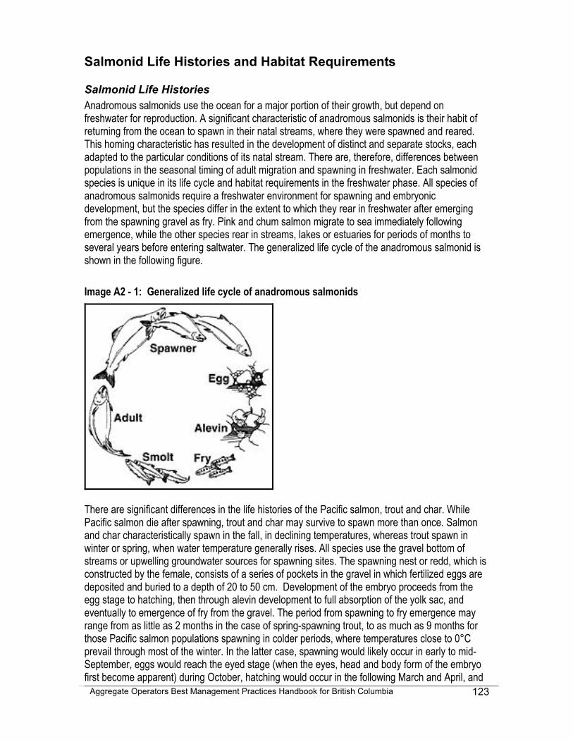
Aggregate Operators Best Management Practices Handbook for British Columbia
123
Salmonid Life Histories and Habitat Requirements
Salmonid Life Histories Anadromous salmonids use the ocean for a major portion of their growth, but depend on freshwater for reproduction. A significant characteristic of anadromous salmonids is their habit of returning from the ocean to spawn in their natal streams, where they were spawned and reared. This homing characteristic has resulted in the development of distinct and separate stocks, each adapted to the particular conditions of its natal stream. There are, therefore, differences between populations in the seasonal timing of adult migration and spawning in freshwater. Each salmonid species is unique in its life cycle and habitat requirements in the freshwater phase. All species of anadromous salmonids require a freshwater environment for spawning and embryonic development, but the species differ in the extent to which they rear in freshwater after emerging from the spawning gravel as fry. Pink and chum salmon migrate to sea immediately following emergence, while the other species rear in streams, lakes or estuaries for periods of months to several years before entering saltwater. The generalized life cycle of the anadromous salmonid is shown in the following figure. Image A2 - 1: Generalized life cycle of anadromous salmonids
There are significant differences in the life histories of the Pacific salmon, trout and char. While Pacific salmon die after spawning, trout and char may survive to spawn more than once. Salmon and char characteristically spawn in the fall, in declining temperatures, whereas trout spawn in winter or spring, when water temperature generally rises. All species use the gravel bottom of streams or upwelling groundwater sources for spawning sites. The spawning nest or redd, which is constructed by the female, consists of a series of pockets in the gravel in which fertilized eggs are deposited and buried to a depth of 20 to 50 cm. Development of the embryo proceeds from the egg stage to hatching, then through alevin development to full absorption of the yolk sac, and eventually to emergence of fry from the gravel. The period from spawning to fry emergence may range from as little as 2 months in the case of spring-spawning trout, to as much as 9 months for those Pacific salmon populations spawning in colder periods, where temperatures close to 0°C prevail through most of the winter. In the latter case, spawning would likely occur in early to mid-September, eggs would reach the eyed stage (when the eyes, head and body form of the embryo first become apparent) during October, hatching would occur in the following March and April, and
Aggregate Operators Best Management Practices Handbook for British Columbia
124
the fry would emerge during May. With the exception of the coastal cutthroat trout and anadromous Dolly Varden char, which use near-shore inter-tidal and estuarine areas, many races of anadromous salmonid species migrate extensively for feeding in the Pacific Ocean. They range between northern California and the Gulf of Alaska, and can be found up to 1600 km offshore. Other races of salmonid species remain and feed in coastal waters, such as Georgia Strait, throughout the marine portion of their life. Several species of trout and char have exclusively freshwater life histories where adult migration, spawning, incubation and rearing all occur in, and between, lakes, rivers and streams.
Salmonid Habitat Requirements Salmonids are a group of fishes adapted to the variable habitat of north temperate, "recently" deglaciated regions. Individually, they often have to cope with severe and variable conditions and as a result might be thought of as an especially "tough" or "insensitive" group of species. They appear to be remarkably resilient in habitat use, in feeding, growth and reproduction, as well as in many other ecological and behavioural characteristics. Despite this, they are environmentally sensitive fishes, particularly with respect to the habitat and water quality requirements of the incubating and rearing portions of their life cycle. The typical food items for those species that use streams for nursery purposes are terrestrial and aquatic invertebrate animals whose own life cycles depend on similar habitat and water quality characteristics as salmonids. Salmonids have different habitat requirements for each life stage, but generally they need fairly cool, well-oxygenated water, a clean gravel substrate, and abundant cover and shade. They need special conditions for successful spawning, for the subsequent development and hatching of eggs and for growth and survival of their young. Fry and juveniles move to different habitats as they grow older, and hence they require access up and down the stream and into smaller tributaries. This may include swampy areas, wetlands, small streams and side channels or intermittently wetted areas. These vital areas may sometimes not seem like appropriate habitat to the untrained eye. Adult salmonids require adequate flow and access to spawning areas for completion of their life cycle. The range and diversity of aquatic environments the various salmonids inhabit throughout their life history combine to make them much more vulnerable to environmental changes. These changes are generally associated with water use and impacts of land use activities on the aquatic environment. Water diversions and pollution, hydroelectric projects, forest harvesting, road construction and land development can each adversely affect salmonids. Their habitat use varies widely with species and also with races of a species, between discrete populations and even between individuals of the same population. This makes it difficult to generalize about their areas of preference and habitat requirements. It also means that salmonid habitat protection and management must be based on specific and up-to-date information about local populations and conditions. Specific environmental requirements of salmonids vary with species; the requirements of different species may even be in direct conflict (e.g., a small log jam may create a nursery area for coho salmon but remove a spawning area for chum or pink salmon). The following is a generalization of the optimum requirements of the habitat characteristics and water conditions of the salmonid freshwater environment:
Aggregate Operators Best Management Practices Handbook for British Columbia
125
Water Temperature A temperature between 12 and 14°C is preferred by the young of all salmon species, with marked avoidance of temperatures above 15°C, and fatality at temperatures of about 24-25°C. Increased stream temperature means more dissolved oxygen (DO) is needed for the increased metabolic rate of fish. However, DO saturation levels decrease with increasing temperature, so lower concentrations of DO are available as temperatures rise.
Dissolved Oxygen (DO) Stream-dwelling salmonids require high levels of DO in both the intragravel and surface waters. It is difficult to set down useful minimum oxygen requirements for stream salmonids given the great diversity of requirements for different life stages, activities and stresses any population experiences. It must be stressed that temperature and water quality markedly affect the levels of DO saturation (i.e., percentage of total saturation at a given temperature) and concentration (mg/l) in stream waters. Generally, optimum DO saturation is greater than 90% and minimum optimum DO concentration is greater than 8 mg/l.
Water Clarity and Suspended Sediment Stream water must be clear enough to permit the sunlight to reach the stream bottom and the algal community where most of the primary production of a stream occurs. Elimination of such production may severely reduce the invertebrate fauna of a stream. Salmonids feed by sight and can have difficulty finding food items in highly turbid water. High concentrations of suspended solids may also directly damage invertebrates and fish, primarily their fragile gill structures. Additional impacts can occur if suspended sediments settle onto stream bottoms and suffocate Incubating salmonid eggs and alevins, and destroy benthic invertebrate populations.
Stream Substrate For successful spawning, salmonids require clean stable gravel, typically located in riffles or runs, depending on fish size and species. High quality gravel will permit redd building and an intragravel flow of water adequate to provide each embryo and alevin with a high concentration of dissolved oxygen and to remove metabolic wastes such as carbon dioxide and ammonia. Clean spawning gravel, from 5 mm to 150 mm in diameter, and larger rocks and cobbles, found on the stream bottom and banks, is required for production of aquatic insects and habitat for young juvenile salmonids.
Riparian Cover and Stream Structure Stream salmonids require cover in the form of undercut banks, logs, rubble substrate, turbulence, deep pools and overhanging streamside vegetation as found in a viable healthy riparian area. Such cover is used by juveniles for feeding areas, as a source of food items, and as refuge for escape and over-wintering. Adult salmonids use deep pools as cover for resting and escape during spawning migrations. Research has also shown that in order to have substantial mixed populations of salmonids, such as the commonly found associations of steelhead trout and coho salmon or cutthroat trout and coho, a stream with a stepped gradient and high proportion of both riffles and

Aggregate Operators Best Management Practices Handbook for British Columbia
126
pools is required. Large organic debris (LOD) forms an integral part of the stream morphology by stabilizing the streambed, by providing habitat, and by altering the stream structure with scours and pools. Naturally occurring LOD, such as fallen logs, root wads and small jams, should not be altered or removed.
Access The spawning and nursery areas of streams must be accessible to adult salmonids migrating upstream, and to fry and juveniles seeking rearing habitat. This includes small feeder streams, wetlands and side channels, which provide valuable habitat in the stream or river environment.
Stream Flow A relatively stable flow, without extreme freshets and droughts, characterizes the best salmon and trout streams. Stable stream flow is characterized by a minimum of freshets and floods causing excessive bed load transport and bank instability, consequently destroying benthos or any developing embryos or alevins that might be in the substrate. While too much water might be detrimental, too little is also damaging. A sufficient flow of water is required for each life stage. Sufficient flows are required during the normal low flow period of late August and September to provide adequate nursery area for the young salmonids and access for returning spawners, and also during the winter, when embryos and alevins in the gravel could be exposed to freezing.
Aggregate Operators Best Management Practices Handbook for British Columbia
127
Appendix 3 - REOMMENDED READINGS AND INTERNET RESOURCES
Aggregate Manager. URL <http://www.aggman.com/>, June 2001.
Aggregate Producers Association of Ontario. (1999): Environmental Management Guide for Ontario Pits and Quarries, Version 2.0.
Austin, L. (2001): Construction Stormwater Pollution Prevention; Stormwater Management Manual for Western Washington, Volume II. Washington State Department of Ecology, Publication 9912, URL <http://www.ecy.wa.gov/biblio/9912.html>, June 2001.
Barksdale, R.D., Editor. (1991): The Aggregate Handbook; National Stone Association.
Bauer, A.M. (1970): A Guide to Site Development and Rehabilitation of Pits and Quarries;. Ontario Department of Mines, Industrial Minerals, Report 33.
Bowers, L.R.II, Broaddus, W.R., Dwyer, J.D., Hines, J.H. and Stansell, R.W. (1990): Processing Plant Principles; in The Aggregate Handbook. Barksdale, R.D. Editor, National Stone Association.
British Columbia Conservation Data Centre, URL <http://www.env.gov.bc.ca/rib/wis/cdc/tracking.htm>, June 2001.
British Columbia Ministry of Employment and Investment. (1997): Mine Emergency Response Plan, Guideline for the Mining Industry; Regional Operations, Health and Safety Branch.
British Columbia Ministry of Energy and Mines. (1997): Health, Safety and Reclamation Code for Mines in British Columbia; Mines Branch, URL <http://www.em.gov.bc.ca/Mining/Healsafe/hsrecode1.htm>, October 2001.
British Columbia Ministry of Energy and Mines. (1998): Audiometric Technical Training Manual; Mines Branch.
British Columbia Ministry of Environment, Lands and Parks. (1992): Guidelines for Industry Emergency Response Contingency Plans; Environmental Emergency Services Branch, URL < http://www.elp.gov.bc.ca/epd/epdpa/sw/giercp.html>, June 2001.
British Columbia Ministry of Environment, Lands and Parks. (2001): Environmental Objectives, Best Management Practices and Requirements for Land Developments; BC Environment, Vancouver Island Region, URL <http://www.elp.gov.bc.ca/vir/pa/bmp_dev1.htm>, October 2001.
British Columbia Ministry of Forests (1994): Visual Landscape Design Training Manual; Recreation Branch.
British Columbia Ministry of Forests and British Columbia Ministry of Environment, Lands and Parks. (1995): Visual Impact Assessment Guidebook; Forest Practices Code of British Columbia. Recreation Branch and BC Environment.
British Columbia Ministry of Forests and British Columbia Ministry of Environment, Lands and Parks. (2001): Visual Impact Assessment Guidebook Second edition; Forest Practices Code of British Columbia. Recreation Branch and BC Environment, URL <http://www.for.gov.bc.ca/TASB/LEGSREGS/FPC/FPCGUIDE/visual/httoc.htm#cont>, June 2001.
Aggregate Operators Best Management Practices Handbook for British Columbia
128
British Columbia Ministry of Forests. (1999): Managing Risk Within a Statutory Framework; Compliance & Enforcement Branch, URL <http://www.for.gov.bc.ca/enforce/risk/>, June 2001.
Buchanan, R. (1999): Gravel Manager's Handbook - DRAFT; British Columbia Ministry of Transportation and Highways, Engineering Branch, Geotechnical Materials & Pavement Engineerign.
Buttleman, C.G. (1992): A Handbook for Reclaiming Sand and Gravel Pits in Minnesota; Minnesota Department of Natural Resources, Division of Minerals.
Chilibeck, B., Chislett, G. and Norris, G. (1992): Land Development Guidelines for the Protection of Aquatic Habitat; Department of Fisheries and Oceans, and Ministry of Environment, Lands and Parks, URL <http://www-heb.pac.dfo-mpo.gc.ca/english/publications/PDF/guidelines/ldg.PDF>, June 2001.
Ciuba, S. and Austin, L. (2001): Runoff Treatment BMPs; in Stormwater Management Manual for Western Washington, Volume V. Washington State Department of Ecology, Publication 9915, URL <http://www.ecy.wa.gov/biblio/9915.html>, June 2001.
Cole, L., Smith, P., Wright, J. and Clough, R. (1999): Controlling the Environmental Effects of Recycled and Secondary Production Good Practice Guidance; United Kingdom Department of the Environment, Transportation and the Regions, URL <http://www.planning.detr.gov.uk/recycled/practice/index.htm>, June 2001.
Conveyor Equipment Manufacturers Association (CEMA). (1988): Belt Conveyors for Bulk Materials; in CEMA Handbook, 3rd Edition.
Coulter, T.S. and Halladay, D.R. (1997): Manual of Control of Erosion and Shallow Slope Movement; Ministry of Transportation and Highways, Vancouver Island Highway Project.
Dunphy, T. (2000): Changing the Way the Game is Played; Aggregate Manager, June 2000, pages 41-43.
Environment Canada. (1993): Export and Import of Hazardous Waste Regulations - User’s Guide to the Hazardous Waste Manifest.
Field, L.Y. and Engel, B.A. (2001): Best Management Practices for Soil Erosion; Purdue University, Agricultural and Biological Engineering Department, URL <http://pasture.ecn.purdue.edu/AGEN521/epadir/erosion/asm521.html>, October 2001.
Fisheries and Oceans Canada (1998): Habitat Conservation and Protection Guidelines; Fish Habitat Management Branch, URL <http://www.dfo-mpo.gc.ca/habitat/c&pguide/english/chap1_e.htm>, June 2001.
Goff, K. (1999): Fugitive Dust; Erosion Control, March 1999, pages 86-95.
Green, J.E., Van Egmond, T.D., Wylie, C., Jones, I., Knapik, L. and Patterson, L.R. (1992): A User Guide to Pit and Quarry Reclamation in Alberta; Alberta Land Conservation and Reclamation Council, Reclamation Research Technical Advisory Committee, 137 pages.
Hanby, I. [Chartered Engineer, Tel 016365 525603, email [email protected]], (2000): Airborne Dust Monitoring Equipment and Services; 4 Elston Hall, Elston Newark NG23 5NP, UK. website www.hanby.co.uk.
Aggregate Operators Best Management Practices Handbook for British Columbia
129
Indian and Northern Affairs Canada (2001): Understanding the Sand and Gravel Business; URL <http://www.ainc-inac.gc.ca/pr/pub/bldg/snd/sgb_e.html>, October 2001.
Indiana Mineral Aggregates Association and the Indiana Geological Survey (2000): Rocks and Minerals in Modern Society, Teachers’ Workshop; Course Materials.
Johnson, K. Editor (1999a): Employee Training; in Sand & Gravel General Permit. Washington State Department of Ecology, Water Quality Program, URL <http://www.ecy.wa.gov/programs/wq/sand/traing.html>, October 2001.
Johnson, K. Editor (1999b): Fact Sheet for Sand and Gravel General Permit; in Sand & Gravel General Permit. Washington State Department of Ecology, Water Quality Program, URL <http://www.ecy.wa.gov/programs/wq/sand/s_g_fact.pdf>, May 2000.
Johnson, K. Editor (1999c): Monitoring and the Monitoring Plan; in Sand & Gravel General Permit. Washington State Department of Ecology, Water Quality Program, URL <http://www.ecy.wa.gov/programs/wq/sand/monitor.html>, June 2001.
Johnson, K. Editor (1999d): Spill Plan; in Sand & Gravel General Permit. Washington State Department of Ecology, Water Quality Program, URL <http://www.ecy.wa.gov/programs/wq/sand/spillpln.html>, June 2001.
King County Washington (1999): Stormwater Pollution Control Manual; Department of Natural Resource, Water and Land Division, URL <http://dnr.metrokc.gov/wlr/dss/spcm.htm>, October 2001.
Lafarge. (2000): Lafarge and the Environment; Information is also available under: "Group Profile>Environment>Examples of Implementation" at, URL <http://www.lafarge.com/>, October 2001.
Mah, K.L. (1983): Guidelines for Aggregate Stockpiling Operations; (Preliminary Draft) Alberta Transportation, Aggregate Services, Materials Engineering Branch.
Mah, K.L. (1987): Security and Safety of Aggregate Pits; Alberta Transportation, Aggregate Services, Materials Engineering Branch, Aggregates Bulletin #6.
Mas-Pla, J., Montaner, J. and Solà, J. (1999): Groundwater Resources And Quality Variations Caused By Gravel Mining in Coastal Streams; in Journal of Hydrology 216 (1999), pages 197-213.
Ministry of Transportation and Highways. (1991): Manual of Aesthetic Design Practice; Engineering Branch.
Murphy, M.L. (1995): Forestry Impacts on Freshwater Habitat of Anadromous Salmonids in the Pacific Northwest and Alaska—Requirements For Protection And Restoration; NOAA Coastal Ocean Program, Decision Analysis Series No. 7, in. Schmitten R. A., Editor, (1996) NMFS National Gravel Extraction Policy, U.S. Department of Commerce National Marine Fisheries Service, URL < http://swr.ucsd.edu/hcd/gravelsw.htm>, June 2001.
National Stone Association. (2001): Community Relations Handbook for the Aggregates Industry; URL <http://www.nssga.org/calendar/pubrelpub.htm>, June 2001.
Aggregate Operators Best Management Practices Handbook for British Columbia
130
National Stone Association. (2001): Storm Water, Environmental, and Clean Air Management Guides; URL < http://www.nssga.org/calendar/envirpub.htm>, June 2001.
National Stone, Sand, and Gravel Association. (2001): URL <http://www.nssga.org/index.shtml>, June 2001.
Nicholson, D.T. (1995): The Visual Impact of Quarry; in Quarry Management, 22 (7), pages 39-42, URL <http://earth.leeds.ac.uk/~dawn/visimp.HTM>, June 2001.
Norman, D.K., Wampler, P.J., Throop, A.H., Schnitzer, E.F. and Roloff, J.M. (1997): Best Management Practices for Reclaiming Surface Mines in Washington and Oregon; Washington State Department of Natural Resources Open File Report 96-2 and Oregon Department of Geology and Mineral Industries Open File Report O-96-2, 128 pages, URL <http://www.wa.gov/dnr/htdocs/ger/pdf/bmp.pdf>, June 2001.
North Carolina Department of Natural Resources and Community Development. (1988): Erosion and Sediment Control Planning and Design Manual; North Carolina Sediment Control Commission.
O'Brien, E. (2001): Minimum Technical Requirements; Stormwater Management Manual for Western Washington, Volume I. Washington State Department of Ecology, Publication 9911, URL <http://www.ecy.wa.gov/biblio/9911.html>, June 2001.
Pit & Quarry University. (2001): URL < http://www.pitandquarry.com/univ.html>, October 2001.
Pit and Quarry. (2001) URL <http://www.pitandquarry.com/>, October 2001.
Polster, D. (1998): Introduction to Soil Bioengineering; British Columbia Ministry of Forests, Resource Tenure & Engineering Brach.
Powell, D.J. (1999): Uses for New Product Fines; The International Center for Aggregates Research (ICAR), URL <http://www.ce.utexas.edu./org/icar/rese.html#uses>, June 2001.
Price, B., Editor (1995): Reclamation and Environmental Protection Handbook for Sand, Gravel and Quarry Operations in British Columbia; British Columbia Ministry of Energy, Mines and Petroleum Resources; Ministry of Transportation and Highways, and Natural Resources Canada.
Price, W.A, and Errington, J.C. (1998): Guidelines for Metal Leaching and Acid Rock Drainage at Minesites in British Columbia; British Columbia Ministry of Energy and Mines, Mines Branch, URL <http://www.em.gov.bc.ca/Mining/MinePer/ardguide.htm>, November 2001.
Quarry Manager. (2001): URL<http://www.hillhead2003.co.uk/qm/> June 2001
Recycling Council of British Columbia. (2001): URL <http://www.rcbc.bc.ca/index.htm>, June 2001.
Reilly, B. (2000): Irving Materials Develops an Outdoor Learning Park for Earth Day Celebration; Aggregate Manager, June 2000.
Snyder, G.R. (1959): Evaluation of Cutthroat Trout Reproduction in Trappers Lake Inlet; Quart. Rept. Colo. Fish. Res. Un. 5: 12-52, in Schmitten R. A., Editor (1996), NMFS National Gravel Extraction Policy, U.S. Department of Commerce National Marine Fisheries Service, URL < http://swr.ucsd.edu/hcd/gravelsw.htm>, June 2001..
Aggregate Operators Best Management Practices Handbook for British Columbia
131
Thomas, M., Editor (2000): Controlling and Mitigating the Environmental Effects of Minerals Extraction in England Consultation Paper; Mineral Planning Guidance Note 11. United Kingdom Department of the Environment, Transportation and the Regions, URL <http://www.planning.detr.gov.uk/consult/mpg11/index.htm>, June 2001.
United States Department of Agriculture and Mississippi State University. (1999): Water Related BMP's in the Landscape; Watershed Science Institute. Created for the Natural Resource Conservation Service, United States Department of Agriculture by the Center for Sustainable Design Mississippi State University Departments of Landscape Architecture, Agricultural and Biological Engineering, and the College of Agriculture and Life Sciences, URL <http://abe.msstate.edu/csd/NRCS-BMPs/contents.html>, October 2001.
United States Department of Agriculture. (2000): Ponds--Planning, Design, and Construction; Agriculture Handbook Number 590.
United States Department of Agriculture, (1994): Planning and Design Manual for the Control of Erosion, Sediment, and Stormwater, Best Management Practice Standards.
United States Department of Labor (2001): Stay Out Alive; Mine Safety and Health Administration (MSHA), URL <http://www.msha.gov/PLACES/WEBRESC.HTM>, June 2001.
United States Environmental Protection Agency (1992): NPDS Storm Water Sampling Guidance Document; Office of Water (EN-336), EPA 833-B-92-001.
Vallack, H.W. [email [email protected],Tel+44 1904 4323 897], (1995): Protocol for Using the Dry Frisbee Dust Deposit Gauge; Stockholm Environmental Institute at York, Biology Department, University of York, Box 373, York Y01 5YW United Kingdom.
Virginia Department of Conservation and Recreation. (1992): Virginia Erosion and Sediment Control Handbook. Third Edition; State of Virginia.
Wright, D.G. and Hopky, G.E. (1998): Guidelines for the Use of Explosives in or Near Canadian Fisheries Waters; Canadian Technical Report of Fisheries and Aquatic Sciences 2107, Department of Fisheries and Oceans Canada, with an update January 05, 2001, URL <http://oceans.ncr.dfo-mpo.gc.ca/sect8/sect82/index_e.htm>, June 2001.
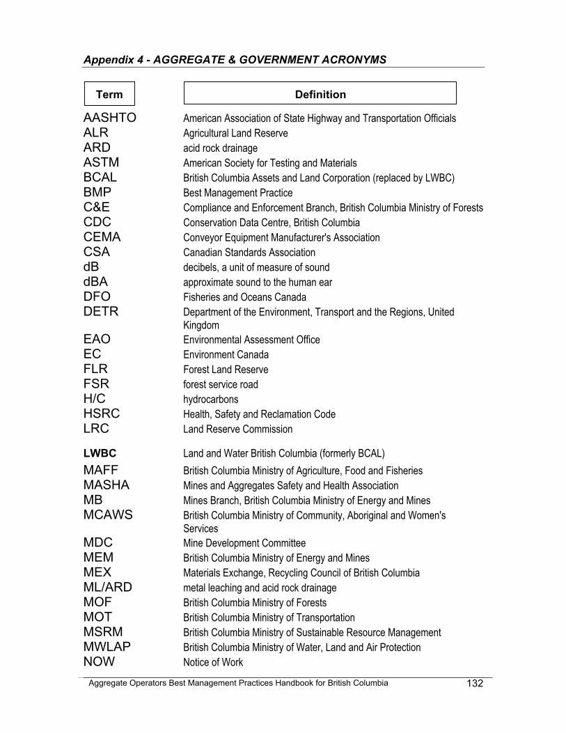
Aggregate Operators Best Management Practices Handbook for British Columbia
132
Appendix 4 - AGGREGATE & GOVERNMENT ACRONYMS
AASHTO American Association of State Highway and Transportation Officials ALR Agricultural Land Reserve ARD acid rock drainage ASTM American Society for Testing and Materials BCAL British Columbia Assets and Land Corporation (replaced by LWBC) BMP Best Management Practice C&E Compliance and Enforcement Branch, British Columbia Ministry of Forests CDC Conservation Data Centre, British Columbia CEMA Conveyor Equipment Manufacturer's Association CSA Canadian Standards Association dB decibels, a unit of measure of sound dBA approximate sound to the human ear DFO Fisheries and Oceans Canada DETR Department of the Environment, Transport and the Regions, United
Kingdom EAO Environmental Assessment Office EC Environment Canada FLR Forest Land Reserve FSR forest service road H/C hydrocarbons HSRC Health, Safety and Reclamation Code LRC Land Reserve Commission
LWBC Land and Water British Columbia (formerly BCAL) MAFF British Columbia Ministry of Agriculture, Food and Fisheries MASHA Mines and Aggregates Safety and Health Association MB Mines Branch, British Columbia Ministry of Energy and Mines MCAWS British Columbia Ministry of Community, Aboriginal and Women's
Services MDC Mine Development Committee MEM British Columbia Ministry of Energy and Mines MEX Materials Exchange, Recycling Council of British Columbia ML/ARD metal leaching and acid rock drainage MOF British Columbia Ministry of Forests MOT British Columbia Ministry of Transportation MSRM British Columbia Ministry of Sustainable Resource Management MWLAP British Columbia Ministry of Water, Land and Air Protection NOW Notice of Work
Term Definition
Aggregate Operators Best Management Practices Handbook for British Columbia
133
NRCS Natural Resources Conservation Service, US Department of Agriculture NSA National Stone Association NTS National Topographic System OCP Official Community Plan OHSC Occupational Health and Safety Committee pH measure of acid or alkalinity of a solution or substance PM10 dust particle of 10 micrometres - unit of measure for fugitive dust particles RCBC Recycling Council of British Columbia RTEB Resource Tenures and Engineering Branch, British Columbia Ministry of
Forests SEI Sensitive Ecosystem Inventory SUP Special Use Permit, British Columbia Ministry of Forests TRIM Terrain Resource Information Management TDS total dissolved solids TSS total suspended solids USDA United States Department of Agriculture WHMIS Workplace Hazardous Material Information System