Embed Size (px)
Citation preview

1
MINISTRY OF AGRICULTURE AND IRRIGATION
THWAKE MULTI-PURPOSE WATER DEVELOPMENT PROGRAM PHASE 1 TERMS OF REFERENCE
FOR CONSULTING SERVICES FOR THWAKEDAM BREAK ANALYSIS AND EMERGENCY
PREPAREDNESS PLAN 1.0 INTRODUCTION
The Government of Kenya (GoK) through the State Department of Irrigation is implementing
Thwake Multi-purpose Water Development Program (TMWDP) comprising a multi-purpose
dam for water supply, hydropower generation and irrigation development in Kitui and Makueni
Counties. It will also provide Regulation of flows on Athi River downstream of the dam for flood
and drought mitigation. The program will be implemented through four phases comprising;
i. Phase (1) Construction of a 77m high multi-purpose dam and associated preliminary
works needed to enable implementation of the other three phases. Implementation
of an environmental and social plan will also be undertaken during this phase.
ii. Phase (2 ) Hydropower and substation development for up to 20 MW of installed
capacity,
iii. Phase (3) Development of water supply system to treat and distribute up to 150,000
cubic metres of water per day to approximately 674,700 rural inhabitants of Kitui
and Makueni Counties and up to 626,000 inhabitants of Konza City and environs.
iv. Phase (4) Development of irrigation works for up to 40,075 hectares of land in Kitui
and Makueni Counties.
The Mainobjectiveisto increase water storage for rural and urban domestic use, irrigation,
livestock and for hydropower with principal focus on the semi-arid counties of Kitui and
Makueni where the dam is located. It entails harnessing of the fluctuating flows of the Athi
River and the seasonal water from Thwake River which traverse the two Counties. At least 1.3
million people are expected to benefit from the program. Phase one of the program is currently
under implementation.
The multi-purpose dam is a flagship Project in the National Water Master Plan 2030. It closely aligns with GOK’s Water Security and Climate Resilience Program (WSCRP) whose twofold focus is to enhance the institutional framework and strengthen capacity for water security and climate resilience in Kenya, and to increase availability of water for irrigation.

2
Detailed Design for the dam has been undertaken and is now the subject of review before construction works. In this regard Thwake Dam Break Analysis andEmergency Preparedness Plan been identified as a complimentary study because the results obtained from the study will be an input in dam design review 2.0 PROJECT OVERVIEW
2.1 ThwakeMulti-purpose Dam The dam civil works comprises of river diversion, earth works for the dam structure and cutoff trench, grouting, two spillway structures an intake tower and site access roads. The dam will be constructed of rock fill and have an impervious concrete face on the upstream slope. It will be 77 m high above the lowest elevation of the river bed, with a crest elevation of 912amasl. At crest elevation, the storage volume in the reservoir would be 681 MCM. A slurry cut-off wall will be provided in the overburden and a grout curtain in the underlying rock. Total earthwork involved would be approximately 10.1 X 10⁶ m3. The service spillway is a reinforced concrete structure 50 m wide by 5 m high with a design capacity is 7,000m3/s. In addition to the main service spillway, there would be an emergency spillway to handle increment of flood water exceeding the capacity of the service spillway. The emergency spillway (2,500 m3/s) comprises an erodible dyke called a fuse-plug which is designed to breach and wash out when overtopped. It is safe, the least cost alternative and easy to reconstruct with locally available materials and equipment. The chance using the emergency spillway depends on the occurrence of infrequent floods. The dike is divided into sections of varying height so that not all sections are simultaneously overtopped, and thus smaller floods can be passed with failure of one or several of the sections. Breaching of one section at a time minimizes the flood wave and the possibility of a sudden failure of the dike. Should discharge occur through the emergency spillway, erosion is controlled by keeping the channel floor flat and lined with a concrete base having a cantilever lip on the downstream side. The control crest of the emergency spillway is kept 0.3 m above the maximum discharge water level of the main service spillway.
2.2 Dam Project Salient Features
A1. LOCATION
Province Eastern
Districts Makueni / Kitui
Source Athi and Thwake Rivers
Drainage Basin Athi River 3F
Purpose Water Supply, Irrigation and Hydropower Generation and Flood Control
Water Demand Present (2010) is 8,000m3/day, future (2020) is 15,000m3/day and Ultimate (2030) is

3
20,400m3/day
A2. CATCHMENT AREA
Area 10,276 km2
Mean Annual Rainfall 700mm
80% Annual Probability Rainfall 567 mm
Mean Annual Evaporation 1677 mm
Average slope 3.7%
Design flood flow Q(1000) for the service spillway
7,500 m3/s
Design flood flow for the emergency spillway
2,500 m3/s
The mean sediment production 450 m3/km2/yr
Accumulated sediment load (50 years) 231MCM
A3. RESERVOIR
Storage Capacity (NWL) 681MCM
Dead Storage 231MCM
Live storage 450MCM
Design life 50 years
Submerged Area 2900ha
Minimum Operating Level 862masl
A4. CONCRETE FACE ROCK FILL DAM (CFRD)
Type Concrete Face Rockfill Dam (CFRD)
Bed Level 840m
Crest Level 917m
NWL 912m
Height 77m
Dead Water Level 860m
Crest Length 1,480m
Submerged Area 2,900ha
Crest Width– present 6m
Upstream Slope 1:1.3
Downstream Slope 1:1.5
Gross Freeboard
5.0m

4
A5. SERVICE SPILLWAY
Type
Side Channel O- gee Spillway (Main) - 2,500 m3/sec
Location Right hand Side in Makueni County
Probable Maximum Flood (PMF) 7,000 m3/s
IDF Capacity 2,500 m3/s
Evacuation capacity for the entire freeboard of 4.8m 5,080 m3/s
Normal Water Level 912 masl
Front width 230m
Freeboard - Depth of water (IDF) 3m
Length of stilling basin 20m
Depth of basin 3m
Outflow Section
Width 50m
Length 762.5m
Depth of water 1.9m
Safe Board above water level 0.5m
Slope 0.0067
Type Open Channel – Emergency
Energy Dissipater
Type Flip Bucket - Inclined 5o
Distance of the Plunge Pool from the edge of the spillway 119m
A6. EMERGENCY SPILLWAY
Location Left Hand Side in Kitui County
Sill level 912.5masl
Capacity 2,500 m3/s
Front width 200m

5
Figure Error! No text of specified style in document.-1: Thwake Dam Location Map
6
Figure Error! No text of specified style in document.2:
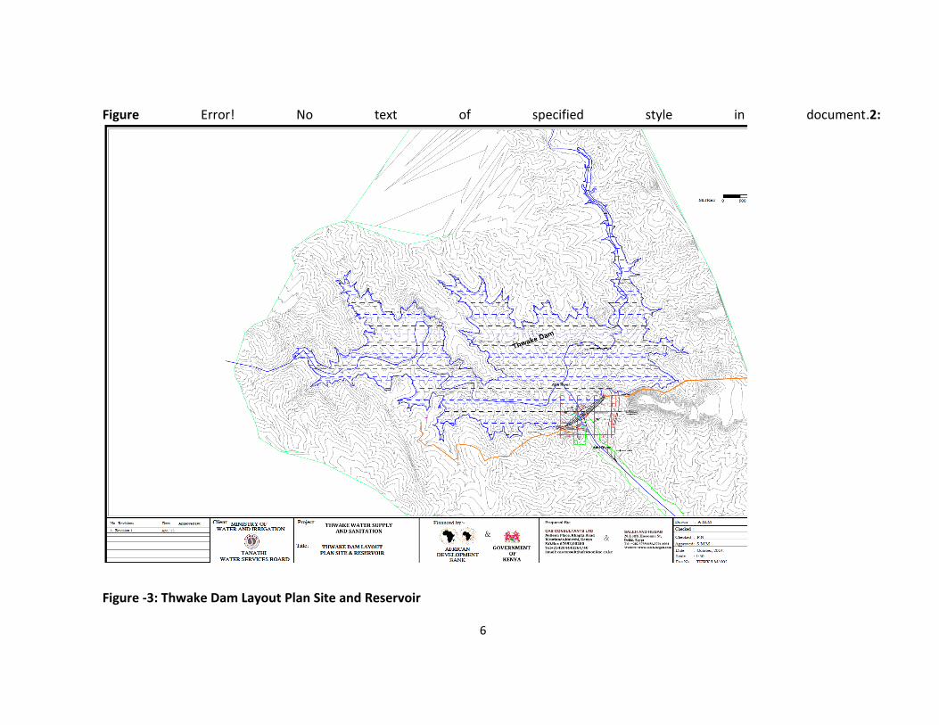
Figure -3: Thwake Dam Layout Plan Site and Reservoir

7
Figure 4: Thwake Dam Layout Plan

8
3.0 SUMMARY OF PREVIOUS STUDIES AND DESIGNS From 2006 to 2008, and from 2012 onwards, the GOK and the African Development Bank, respectively, have funded studies for Athi River basin and detailed designs for the Thwake Multi-Purpose Dam Project as described below. 3.1 Consultant Teams 3.1.1 Samez Consultants, Kenya In June 2006, Samez was commissioned by the National Water Conservation and Pipeline Corporation to undertake Athi River Basin Water Resources Development Study to identify dam sites with potential for multi-purpose water usage. In Dec 2006, Samez prepared a rapid desk review of hydropower and irrigation potential of the identified sites. The consultant then prepared concepts for Thwake dam comprising rural water supply and treatment, hydropower and irrigation. In Feb 2008, Samez prepared a preliminary evaluation from three boreholes (15 – 20 m deep) along the dam axis, one borehole (BH) in a proposed saddle and one in a potential materials site; 22 shallow test pits, and further interpretations from horizontal electrical resistivity profiling and vertical electric soundings. A draft final design report, plus 21 drawings for the dam (plans and sections of embankment, spillway and intake tower) and 38 rural water supply drawings (site plans, treatment plant, transmission main and storage tanks) and tender documents were submitted in 2008 at the end of the Samez assignment.Samez proposed an earth dam with crest length 1.6 km long, 84 m high with a service spillway designed for a 1:1000 return period flood of 5,350 m3/s, plus two turbines of 10 MW each. The design was based on contours derived from satellite imagery without implementation of a detailed topographic survey. Samez also prepared designs for a water treatment plant and rural water system, and an environmental report. 3.1.2 Saleh-Hegab / CAS Joint Venture, Egypt & Kenya (SH/C JV) In 2011, the Thwake dam project was again taken up, this time by the Tanathi Water Services Board (TAWSB) located in Kitui. Funding under the Small Towns WSS Project was provided by AFDB for the review of the Samez reports and drawings and to design the “water supply, flood control, hydropower generation and irrigation” components. TAWSB awarded the 60 man-month contract in March 2012 to the joint venture to be completed over an 8 month period. The project was recast as a program with four phases. A team comprising MEWNR, TAWSB, AFDB, a panel of three experts (PE) and the consultant firm was established. A feasibility study (2 revisions) and financial and economic analysis were prepared for the program, design reports for the dam (3 revisions), water supply (3 revisions), geotechnical report, hydropower (3 revisions), irrigation (2 revisions), hydrology (3 revisions) and drawings were prepared. The Bank provided comments on the reports and drawings which were submitted by the consultant as substantially complete.

9
A Li-Dar survey was undertaken and contours produced although the accuracy of the digital ground model is limited because there was no ground beacons used for planar rectification. Geotechnical explorations included a drilling program of 20 boreholes, of which five were in potential materials sites (depths averaged 15 – 20 m), three were along the emergency spillway alignment and 8 were along the dam axis, with additional interpretations provided by electrical resistivity tomography, ERT. A factual drilling report of the initial drilling was prepared by the drilling firm (DPI, Kenya) and SH/C JV produced a geology report and a geotechnical investigations report, but no suitably scaled and detailed geological map of the site was developed. (Ref. 13-17) Hydrology studies comprised a review of some 50 years of streamflow data from a gauge located approximately 1 km upstream of the dam site just below the confluence of the AthiandThwake Rivers. There was no surface water modelling undertaken, or review of actual upstream and downstream water abstractions. The low flow reserve was set at the flow exceeded 90% of the time whereas WRMA only require it to be set at the 95% exceedence level, but for large projects this should be confirmed to ensure it is adequate for downstream needs and ecology. An inflow design flood (IDF) for 1:1000 return period was estimated at 4,550 m3/s, though the hydrological basis for the determination of this flood was questionable. In order to proceed further with design, the IDF was increased by 50%, with the understanding that the IDF would be confirmed at a later time. The consultant also prepared a Strategic Environmental Impact Assessment (ESIA) report in June 2013. Reservoir yield analysis was done by calculating the average daily flow of each month over a 49 year period of data. A preliminary analysis was then undertaken that was not deemed to be satisfactory, and thus the analysis by the hydrotechnical member of the panel should be used because it is based on daily analysis over the entire flow record. Preliminary designs were prepared by SH/C JV for the powerhouse and substation, but no drawings were prepared of 52 km power transmission line, penstock profile and layout of tailrace. The SH/C JV contract is to end in July 2014. 3.1.3 Prasol Training and Consulting Ltd., Kenya In 2013, TAWSB financed a resettlement action plan (RAP) and an Environmental and Social Impact Assessment Report, undertaken by Prasol. The RAP and ESIA met the requirements of the Bank’s resettlement and environmental policies for phase 1. A Statement of Conditions from the National Environmental Management Association (NEMA) was issued with the approval of the ESIA. The Water Resources Management Authority (WRMA) also issued an approval for the obstruction of the Athi River by the Thwakedam.Both documents were submitted to the Bank.

10
3.1.4 Assessments of the Panel of Experts In February 2013, a panel of experts (PE) was set up to provide an independent perspective on the hydrology (Dr S. Avery), hydrotechnical (Dr. K. Zhao) and civil works / geotechnical assessments (G.Watson). Although the panel reviewed most of the previous studies, they focused mainly on the requirements of Phase 1. Reports as they were produced by SH/C JV were reviewed and discussed in progress meetings (2013-14) with the PE, the TAWSB, MEWNR, AfDB while meetings were also held with the National Irrigation Board and KenGen. A summary of some key findings by the panel of experts specifically on hyrology is given below; 3.1.5 Hydrological Assessment The PE, Dr. Sean Avery (Kenya), recommended that SH/C JV assess the flow data in consideration of the following: i) the hydrological flow series be naturalized for basin transformation and the effect of past and project future urbanization, ii) the inflow design flood and the construction flood, iii) the peak floods used in the frequency analysis need to be revised to consider upstream abstractions and existing and proposed storage and transfer schemes, such as Munyu dam, transfer from Tana to Athi basin, transfer from Athi to Sabaki1, iv) downstream water demands, v) initial impoundment period, and vi) required conservation flow. The PE reviewed the gauging station data near the dam site (RGS 3F02) and no data available between March 91 – Jan 94, and Nov 96 – May 2009, plus other shorter time periods. The PE selected and undertook a preliminary analysis of a stable nearby river gauging station, RGS 4BE1 and RGS 3F02. The PE noted the scale of difference by about a factor of three, and plotted the original and revised infilled series below. His findings were that:
1952 to 1961 – 3F02 ~ 3F02 was roughly 3 times larger than 4BE1 1961 to 1971 – 3F02 ~ 3F02 was roughly 2 times more than 4BE1 1971 to 1982 – 3F02 ~ 3F02 was roughly 2 times more than 4BE1 1982 to 2012 – data was not recorded between 1992 to 1993, and 1997 to 2008.
1Kenya National Water Master Plan 2030, Vol. I, Fig. 7.7.1

11
RGS 3F02 infilled series were plotted against Makindu rainfall (9237000) and Machakos dam rainfall (9137098), both within the Athi basin. The double mass curves below show correlation between rainfall at Makundu and 3F02 discharge over 1957 to 1986, and correlation between rainfall at Machakos dam and 3F02 discharge over 1960 to 2009.
A rating curve was created using data spanning 1980 to 1987. However, the rating curve data could be categorized by periods of measurement and plots of stage versus discharge for selected groups of years prepared to check the range of possible operation of the rating curves. Evapotranspiration data used by SH/C JV was found by the PE to be representative of the area. The PE prepared the following reports: Report 1 – Hydrology (March 2013); Independent Review Panel Report 2 – Hydrology (July 2013) and Independent Review Panel Report 3 (August 2013). 3.1.6 Hydro-technical Assessment The hydrotechnical PE, Dr. Ken Zhao (Canada), prepared an analysis of a 77 m high dam with the outlets proposed in the SH/C JV design. The analysis was done using daily flow data from 1957 to 2012 and the simulation performed with HEC ResSim software of the USACE. The model simulates release rate by using a rule-based description of the operational goals, priorities and constraints that the reservoir operator considers when making release decisions. By varying the elevation of the Guide Curve, the consultant assessed the maximum daily firm energy and reliability of water supply for domestic and irrigation use. The PE prepared a draft report on the ResSim model exercise; the final report will include the native input and output files in the third quarter of 2014. A second phase of modeling is required and has been planned for
y = 1.5119xR² = 0.997
3F0
2 C
um
ula
tive
Dis
char
ge (
MC
M)
Machakos Dam Cumulative Rainfall (mm)
1960-2009
y = 1.836xR² = 0.9973
3F0
2 C
um
ula
tive
Dis
char
ge (
MC
M)
Makindu Cumulative Rainfall (mm)
1957-1986

12
4.0 OBJECTIVES OF THE ASSIGNMENT
Key Objective
Study to identify "what if" scenarios in the event of dam breach, to identify potential loss of infrastructure, human and animal life, and to develop response plans and protocols
Scope of Work
The Consultant will familiarize himself with the main technical elements of the Project’s design including the Thwake Dam, Main Spillway, Emergency Spillway and Intake Structure. The Consultant will carry out an assessment of the flood discharge due to operating or structural failure of Thwake dam covering flood impact for the areas downstream of the dam.
In their operations, members of the consultancy will be guided by the International Commission on Large Dams (ICOLD) guidelines and other related national legislative regulations, standards, and guidelines as well as well as the World Bank policy on Safety of Dams.
The specific elements to be undertaken by the Consultant shall include but not necessary be limited to the following;
I. Review the design criteria of the Thwake Dam under proposed operation of the reservoir as informed by the separate study (study on management and operation of Thwake Dam) and propose necessary measures to ensure that the safety of the main dam is not jeopardized at any time;
II. Identification and modelling of the dam breach mechanism. The dam breach hydraulic model developed for the dam shall consider various failure modes including an overtopping flood failure due to the Dam Crest Flood (DCF); an overtopping flood failure due to the Probable Maximum Flood (PMF); and a sunny day failure.
III. Computation of the relevant inflow hydrographs to the reservoir, reservoir storage characteristics, spillway outflow and tailwater conditions and the outflow hydrograph through the breach as affected by the breach.
IV. Routing of the outflow hydrograph through the downstream valley taking into account the storage, frictional resistance, and important downstream structures such as weirs.
V. Mapping of the flood levels determined from the modelling, utilising available mapping.
VI. Develop and apply a flood inundation model and determine inundation areas, time of flood wave reaching areas, water depth, velocities, etc.;
VII. Identify key facilities and emergency responders relevant to emergency management operations
VIII. Map the flooded areas downstream of Thwake Dam for the various scenarios, utilising available mapping;
IX. Produce an inundation mapping book summarizing scenarios; and
X. Prepare an Emergency Preparedness Plan for Thwake Dam.

13
Deliverables 1. Dam Break Analysis report; and 2. Emergency Preparedness Plan
Anticipated Schedule
Consulting services will be required for approximately four months from commencement date.
Qualification of the Consultant
The consultant must be a company/firm with proven experience on similar Assignments - demonstration of not less than 10 years’ experience and successful project completion in the following disciplines:
Concrete Face Rock Fill Dams planning, feasibility studies, Detailed Design and Construction Supervision
Flood Routing Studies
Dam Break Analyses
Dam Safety, including preparation of Emergency Preparedness Plans
Dams design in Sub-Saharan Africa
Environmental and Social Impact Assessment Studies in Sub-Saharan Africa
Information on the experience of the firm(s) in the provision of similar services in the last ten (10) years should be given with the following details and contact details of the Client:
I. Name of client to which service/assignment of similar nature was provided and duration,
II. Name and location of the project or assignment; and,
III. Value of comparable assignment(s) (professional fee and construction cost)
The Consultant must also provide the following details:
Background; registration, organization and experience of the firm/joint venture
Relevant financial data sheet indicating the firm’s financial capability
Qualifications of Key Experts
1. A hydrologist with minimum BSc. In Civil/Water/ Agricultural Engineering and Master’s degree in hydrological studies. He/she must have a minimum of twenty (20) years’ experience in hydrological/water resources analysis. He/she must have carried out dam break studies for at least three (3) projects. The hydrologist will be the Team Leader of this assignment.
2. Dams Engineer with a minimum of a Master’s degree in Civil Engineering. He/she must have a minimum of twenty (20) years’ experience in dams engineering. He should have designed at least five (5) Concrete Face Rock fill Dams. He/she must have experience in dams engineering in sub-Saharan Africa.

14
3. A Dam Safety Expert with minimum with a minimum of a Master’s degree in Civil/Construction Engineering and twenty (20) years’ experience in dams feasibility studies, design and construction. He/she must have been involved in dam safety studies or monitoring for at least five (5) projects.
4. An Environmental/Social Expert with minimum of post graduate qualification in environmental studies. He/she should have a minimum of twenty (20) years’ experience in environmental/social studies, and at least five (5) dam’s project. He/she must be registered with an equivalent body of National Environment Management Authority of Kenya. He/she must have been involved in environmental/social studies of at least three (3) projects in Africa.
5. A Geotechnical Engineer/geologist with a minimum of a bachelor’s degree in geotechnical engineering/ geology. He/she must have a post graduate qualification in geotechnical/geological studies. He she must have a twenty (20) years’ experience in geological studies related to dams’ projects. He she must have been involved in geological/geotechnical studies of at least three (3) dams projects in sub-Saharan Africa.
5.0 REPORTING REQUIREMENTS AND TIME SCHEDULE FOR DELIVERABLES After selection and award of the assignment, the time schedule for the completion of the study and reporting is as follows:
No Description Due date for submission after effective date of contract agreement
1 Inception Report 15 days from commencement
2 Draft Interim Report presenting Tasks A, B, C and D.
60 days from commencements
3 Final Interim Report presenting Tasks A, B, C and D.
75 days from commencement
2 Draft Final Report presenting all tasks.
105 days from commencement
3 Final Report 120 days after the date of Commencement
The Final Report will be also submitted on CD and 10 hard copies which will contain all reports, maps, data and processed results.

15
6.0 PAYMENT SCHEDULE Schedule of Payment for this work will be as follows:
No. Description % of Contract Amount
1 First installment will be released upon submission and approval of Inception Report
20%
2 Second installment- submission and approval of Interim Report
40%
3 Third installment- submission and approval of Final Report 40%
7.0CLIENT’S INPUT Services, facilities and property to be made available to the Consultant by the Client:
i. Historic data on the river stage and discharge. ii. Survey data for the channel showing the geometry and cross -sections of the river at
various points. iii. Topographical-maps for the area and also the river basin iv Hydro-meteorological data v. Climate scenario data which includes the various variables and extremities Provisions should be made for acquisition of extra data that may be required.