Embed Size (px)
Citation preview

YARRA RANGES PLANNING SCHEME
21 MUNICIPAL STRATEGIC STATEMENT
21.01-1 Snapshot of Yarra Ranges
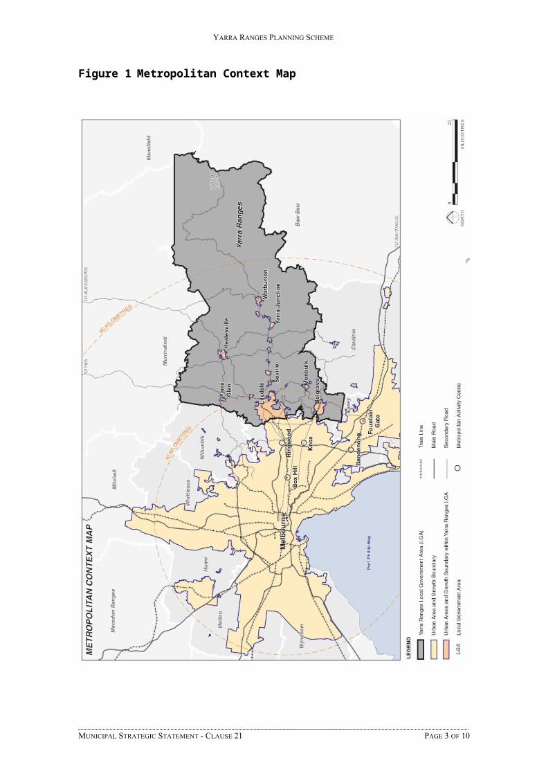
Yarra Ranges is located on the eastern fringe of metropolitan Melbourne. It has a combination of urban and rural communities. Around 70% of Yarra Ranges’ population live in its suburbs and towns (which occupy approximately 3% of its total area) with the balance of its population being scattered throughout rural areas. There are over 55 suburbs, towns and small rural communities within Yarra Ranges.
Yarra Ranges is one of the largest municipalities in the Melbourne metropolitan region with a total area of approximately 244,700 hectares. Around 73,410 hectares (30%) of this area is private land that is managed by land owners and occupiers.
Yarra Ranges has an unusually large proportion of public land. 166,396 hectares (68% of the municipality) is Crown Land, the majority of which is managed by the Victorian Government as national parks, protected water catchments, state forests and other reserves. 4,894 hectares (2%) is land owned and managed by Yarra Ranges Council as parkland or land used for municipal purposes.
Environment
Yarra Ranges has long been recognised as a special place for its natural beauty and diverse habitats. The environmental characteristics of the municipality are a significant factor in attracting residents and tourists to the municipality.
The combination of scenic rural landscapes, national parks, state forests and private gardens together with its location on the doorstep of Melbourne all contribute to Yarra Ranges’ unique set of natural, cultural and amenity values. The municipality contains some of the most environmentally important areas in Victoria. Its mountain ranges and valleys contain extensive areas of remnant indigenous vegetation, much of which is botanically and zoologically significant, providing important habitat for wildlife.
Yarra Ranges has many important waterways, including the Yarra River and its tributaries, and the upper portion of the Dandenong Creek catchment. The Yarra River, upstream of the Yering Gorge pumping station is an important water supply catchment for Melbourne.
Economy
Yarra Ranges has a diverse economy. Manufacturing continues to represent the single most valuable sector of the local economy, with the other key sectors including construction, property and business services, retail trade and agriculture.
The Green Wedge areas of Yarra Ranges support a significant agricultural sector, and the Yarra Valley has gained local and international recognition as a fine food and wine producing area. Floriculture and other forms of horticulture continue to be a strong contributor to the local economy with forestry remaining a source of economic activity in some of the towns of the upper Yarra Valley.
Yarra Ranges is a significant tourist destination for local, interstate and overseas visitors with major attractions including the wineries and landscapes of the Yarra Valley, rural towns such as Healesville and Warburton, mountain forests, and the Dandenong Ranges.
Community
Yarra Ranges has a estimated population of approximately 149,300. Current population forecasts indicate that the Yarra Ranges’ population will continue to grow at an average
MUNICIPAL STRATEGIC STATEMENT - CLAUSE 21 PAGE 1 OF 10
--/--/20--C----/--/20--Proposed C148

YARRA RANGES PLANNING SCHEME
rate of 0.71% each year reaching approximately 173,000 people by 2036. Most of this increase is expected to be within the established urban areas of Lilydale, Chirnside Park and Mooroolbark.
Generally Yarra Ranges has a low proportion of residents born overseas compared with other parts of Melbourne. Although earlier phases of immigration led to significant Italian, German and Dutch communities establishing in some areas. More recent arrivals have mostly been from the Burmese and Sudanese communities. Yarra Ranges also has the highest concentration of indigenous people in the eastern metropolitan region of Melbourne.
Although the characteristics of Yarra Ranges’ communities vary, the population of the municipality is expected to age over the next 20 years with a decline in people aged between 10 and 24 years of age and substantial increases in people over 70 years of age.
Yarra Ranges has a higher level of socio economic disadvantage than other municipalities of the eastern metropolitan region with particular pockets of disadvantage concentrated in some of its smaller rural communities.
Many residents value living within or being in close proximity to the area’s scenic and bushland environments and have therefore traded off urban convenience for the lifestyle benefits of living in a more spacious and treed environment.
MUNICIPAL STRATEGIC STATEMENT - CLAUSE 21 PAGE 2 OF 10
YARRA RANGES PLANNING SCHEME
Figure 1 Metropolitan Context Map
MUNICIPAL STRATEGIC STATEMENT - CLAUSE 21 PAGE 3 OF 10

YARRA RANGES PLANNING SCHEME
21.01-2 Key issues and influences
The key planning issues facing Yarra Ranges are focussed around five strategic themes:
Settlement and Housing
Yarra Ranges has an unusual settlement pattern comprising suburban areas and an extensive Green Wedge area that includes scattered rural towns, extensive rural residential areas and rural communities.
Some of these communities, especially in smaller rural localities have relatively poor access to a diversity of employment and education opportunities.
The demographic characteristics of its various communities will continue to evolve and there is a limited diversity of housing stock to meet the anticipated future housing needs associated with these changes.
Yarra Ranges has a well distributed network of activity centres that offer a range of services and employment opportunities in its suburbs and larger rural towns. The consolidation of additional higher density housing opportunities around these centres can increase the proportion of housing that is conveniently accessible to employment, community facilities and public transport.
Further opportunities for additional housing and employment will become available in key strategic redevelopment sites.
Although there are latent pressures to expand urban development into the Green Wedge there is sufficient capacity within established urban areas to accommodate future housing needs.
Economic development
Yarra Ranges’ urban fringe location results in a high level of interaction with adjoining municipalities and the wider Melbourne metropolitan region. Many of its residents travel outside the municipality to access jobs and higher level services, although Yarra Ranges also has a significant number of home based businesses.
Many people from other parts of the metropolitan region travel to Yarra Ranges to enjoy the leisure and recreation opportunities available in its Green Wedge areas.
Yarra Ranges has a relatively narrow economic base with a limited range of higher level employment and tertiary educational opportunities. Much of the local employment available in Yarra Ranges is in sectors such as manufacturing and retailing which have limited long term prospects for jobs growth.
Its Green Wedge contains extensive areas of potentially productive agricultural land which support a strong agricultural sector. Floriculture and other forms of horticulture including wine grape growing are important elements of the local economy.
Agriculture in Yarra Ranges will continue to evolve in response to changes in economic and climatic conditions. The areas of potentially productive agricultural land will need to be managed to retain long term opportunities for future agricultural use.
The scenic landscapes of the Yarra Ranges Green Wedge and its proximity to the metropolitan region will attract ongoing interest in providing tourism and hospitality services. Although this sector will provide new opportunities to broaden the economic base of the region it needs to be managed to protect the primary values of the Green Wedge.
Built form
Scenic landscapes are a key contributor to the identity of Yarra Ranges and poorly designed new development can detract from these landscapes.
The quality and presentation of buildings and public places in Yarra Ranges’ activity centres plays a significant role in creating a sense of place for local communities.
MUNICIPAL STRATEGIC STATEMENT - CLAUSE 21 PAGE 4 OF 10
YARRA RANGES PLANNING SCHEME
Much of the building stock in Yarra Ranges comprises modest buildings constructed before the introduction of environmentally sustainable design concepts.
The construction of sustainably designed new buildings and public places can help reduce consumption of finite resources. It can also contribute to safer and healthier communities by encouraging use of outdoor spaces and community interaction.
Yarra Ranges’ diversity of heritage buildings and places reflect its origins and contribute to its overall identity. There is a need to recognise and protect the important elements of this heritage.
Environment
Yarra Ranges retains extensive areas of forested land together with a complex network of more fragmented remnants of indigenous vegetation and waterways. These areas, which provide habitats for a rich biodiversity, are one of the defining characteristics of the municipality. It is important to sustainably manage these habitat areas and there are many opportunities to improve the connections between them.
The combination of Yarra Ranges’ natural topography, its urban fringe location and projected climate changes have resulted in many communities being exposed to significant environmental hazards including bushfire, landslip and flooding. There is a need to ensure that priority is given to the protection of human life in the management of areas that are affected by environmental hazards.
The Yarra River including areas downstream of the main forested catchment areas are a vitally important source of water supply for metropolitan Melbourne. Land use and development within these catchment areas may have an adverse impact on water quality within Yarra Ranges waterways.
Physical and community infrastructure
The generally low density and widely dispersed settlement pattern in Yarra Ranges’ creates major challenges in meeting community expectations about the appropriate level of services and infrastructure.
Many communities especially in the Dandenong Ranges are not serviced by reticulated sewerage which has adverse impacts on the local environment and waterway network.
Yarra Ranges has a vast network of public open space assets serving its diverse communities. This open space network needs to be managed so that it is adaptable to the changing needs of local communities.
Most communities in Yarra Ranges have a very high dependency on motor car transport due to the dispersed settlement pattern and limited public transport infrastructure. Motor cars remain the dominant form of transport for most people. Appropriately located new development can increase the proportion of residents living in areas that have convenient access to a range of transport options and other community infrastructure.
There is a need to ensure that major developments in strategic redevelopment sites make appropriate contributions to address community infrastructure needs.
21.01-3 Vision
The Yarra Ranges Council Plan states:
The Shire of Yarra Ranges will be a vibrant and dynamic Shire based on strong local communities living in a place of great natural beauty. Our world class Shire will be sustained by a strong local economy and rich social fabric that is consistent with and supports its environmental values.
21.01-3 Strategic vision
MUNICIPAL STRATEGIC STATEMENT - CLAUSE 21 PAGE 5 OF 10

YARRA RANGES PLANNING SCHEME
Yarra Ranges will lead the way in showing how the evolving needs of a growing community can be sustainably met without compromising its natural assets.
Yarra Ranges’ identity
Yarra Ranges will have a distinctive identity that embraces its urban fringe location and its unique mix of suburbs, rural towns and scenic landscapes. The natural environment will continue to be the most defining characteristic of Yarra Ranges. The varied topography of its urban and rural landscapes will continue to be dominated by hills and trees.
Communities and activity centres
Within the suburbs and towns of Yarra Ranges a network of activity centres will provide a complementary range of housing types, employment opportunities, commercial services and community infrastructure. The surrounding neighbourhoods will continue to provide attractive and well serviced living environments. The areas close to the largest activity centres will include more diverse and higher density neighbourhoods that have broadened the range of housing options available.
Urban containment
The redevelopment of urban areas, including key sites such as the Chirnside Park Activity Centre, the former Cave Hill Quarry and the former Swinburne University, will have expanded the diversity of housing, education, recreation and employment opportunities in Yarra Ranges. This more efficient use of the urban land area will have avoided the need for urban development to encroach into the Green Wedge.
Circulation
Although private motor cars will continue to be the most dominant form of transport more people will have access to a range of transport options. A targeted program of road network improvements will have ensured that road transport is safe and efficient. A reduced dependence on private motor cars will have been achieved by public transport improvements associated with the increased intensity of development in the activity centres, and through the expanding network of pedestrian and bike trails.
Community infrastructure
An equitably distributed array of well designed and adaptable community facilities and public places will have generated increased community interaction and a greater sense of community safety. Public open space areas and recreational facilities that respond to emerging community needs will encourage increased physical activity and provide an enhanced opportunity for all Yarra Ranges residents to lead healthy lifestyles within a safe environment.
Green Wedges
The Green Wedge areas of Yarra Ranges will continue to support a diverse mosaic of productive agricultural activities, rural lifestyle opportunities and bushland areas. Land subdivision, new development, and changes to land use, will continue to be managed in a way that protects and enhances the primary Green Wedge values of supporting sustainable farming, retaining a healthy biodiversity and protecting valued landscapes.
Biodiversity
The long term sustainability of Yarra Ranges’ rich biodiversity will have been retained through a strategic approach to land and water management that has protected flora and fauna habitats and enhanced the network of linkages between them. By recognising and planning for the risks associated with projected climate changes, the adverse effects of water scarcity, bushfire, flood and landslip events will have been minimised.
Built form
The built form of development will be a positive feature of Yarra Ranges. Its newer buildings will have been designed to leave a positive legacy for future generations. They will adopt environmentally sustainable design principles, be accessible to people of all abilities, respect recognised heritage assets and will reinforce the valued characteristics of their surroundings.
MUNICIPAL STRATEGIC STATEMENT - CLAUSE 21 PAGE 6 OF 10
YARRA RANGES PLANNING SCHEME
MUNICIPAL STRATEGIC STATEMENT - CLAUSE 21 PAGE 7 OF 10

YARRA RANGES PLANNING SCHEME
Figure 2 Strategic Framework Plan
MUNICIPAL STRATEGIC STATEMENT - CLAUSE 21 PAGE 8 OF 10
YARRA RANGES PLANNING SCHEME
MUNICIPAL STRATEGIC STATEMENT - CLAUSE 21 PAGE 9 OF 10

YARRA RANGES PLANNING SCHEME
Figure 3 Strategic Framework Plan (Urban Detail)
MUNICIPAL STRATEGIC STATEMENT - CLAUSE 21 PAGE 10 OF 10