Embed Size (px)
Citation preview

(
(
(
(
(
l
(
(
l
(
(
c c c (
(
(
L
L
L
c (
w MININGPLA
OVER AN EXT ·---~ ....... IN SY. NO. 116/2 PALKUR (V), BANAfiJ~m~'t'"A~~~;:::~-· / KURNOOL DISTRICT,
ESH
Mines & Minerals (Development & Regulation) Act, 1957
(Under Rule 7(A) ofM.M.C.R., 1966 and as per the G.O. Ms. No. 56, Industries and Commerce (Mines- II) 30th April, 2016)
(OTHER THAN FULLY MECHANISED MINE CATEGORY-B) (OWNERSHIP: PATTA LAND)
~
t\F'lPROftD For
SRI.G.CHENNA REDDY, S/o.G.ROSI REDDY,
R/o.PALKUR VILLAGE, BANAGANAPALUMANDA~
KURNOOL DISTRICT, ANDHRA PRADESH STATE. Contact No. 7285923781.
Prepared by
G.ESWAR REDDY M.Sc.,B L., RQP /Geologist,
RQP/DMG/ AP/07 /2014, IBM/RQP/HYD/302/20 13/ A'
D.No.13-2-155-1, Shirdi Nagar, ANANTAPURAMU 515001.
Mobile:09849132789.Phone No: 085554 222737. Email: [email protected]
MARCH- 2017

c.
(.,
L...
l
l
( .
.-.. -~ .. - :· ···-.. .. -:<\ · .... -!tf)~· -~-.
. • ·'· .. J ~, . , .
/ .
•• • • ., \ ... ~ ..... "-...-'';"~~"'· . t ...
. "", ~~.,. .. . \1·. ,~ . :..: ·
/ . --~~:.~ '(. _:..,.~ .. ; .. :,~,~:·>~ /~: ./ .. (~_;<,~··,·· ·-~,~~·~~ (~-~~.·-\~
, . .. ! •.·· .7 - . ·~. ~~ · ~ '····
~, -· . ·l l .. (-:'~>' ·DEC · RA:T,QN , t ;!·: f N.l;•.·.· .• : · ,. "~~ ··: :- ~ '·;;~!
This mining plan forf?: .~'\:..;~::~~~Wi~~ for Limestone Slabs (Black) over
an extent of 2.408 >i''·._~$~~~1 72 of Palkur Village, Banaganapalle
M'andal, Kurnool District, Ari'gh1~ sh State, prepared in consultation with me
and I understand its contents and agreed to implement the same in accordance
of APMMC Rule 28.
Place : Palkur.
Date :15-03-2017
APPLICANT .
"j\'1~~~ ~~3 ~ SRI.G.CHENNA REDDY
CERTIFICATE
This is to certify that Mining Plan in respect of quarry lease applied area for
Limestone Slabs (Black) over an extent of 2.408 Hects.in Sy. No. 116/2 of Palkur
Village, Banaganapalle Mandai, Kurnool District, Andhra Pradesh State,
prepared by G.Eswar Reddy Consultant Geologist & RQP from M/s. Sai Geo
Services, Office at Anantapuramu. The applicant agrees to follow the same in
accordance to the provisions of law.
Date:lS-03-2017.
Place: Palkur.
Signature of the Applicant
~ ~ ~ -w ;:r;,') :-Bb ACV ~ ~ '<l
SRI.G.CHENNA REDDY

l
(
(
(
C;
(
The provisions of Granite Conservation and Development Rules 1999 & APMMC
Rule 7 (A) observed in preparation of Mining Plan for quarry lease applied area
for Limestone Slabs (Black) over an extent of 2.408 Hects.in Sy. No. 116/2 of
Palkur Village, Banaganapalle Mandai, Kurnool District, Andhra Pradesh State.
Wherever specific permissions are required the applicant will approach the
concerned authorities.
Certified that the information provided in the mining plan is correct to the best of
my knowledge.
Date:lS-03-2017.
Place: Anantapuramu.
Signature of the RQP
(G.Eswar Reddy)
G. ESWAR REDDY. M.Sc., B.L PhD.
Recognised Geologist IBM/RQP/HYD/302/2013/A RQP/DMG/AP/07/201~

f ' I
t I
(
L
l
S.NO.
1 I II III
1
2
3
4
5
6
7
8
1
2
3
4
5 6 7 8
9
10
11
PLATE-1 PLATE-2 PLATE-3 PLATE-4 PLATE-S PLATE-6 PLATE-7
PART-A GENERAL DETAILS OF APPLIED AREA
GEOLOGY & EXPLORATION
MINING QUARRYING & RESERVES
MINE DRAINAGE MARKET ANALYSIS
WAST[ MANAGCMCNT PLAN
USE OF MINERAL AND MINERAL REJECT
PROCESSING OF ROM AND MINERAL REJECT
OTHERS
PART-B
PAGE No.
3 1 2 5
5
5
10
14
14
15
15
15
PROGRESSIVE MINE CLOSURE PLAN ENVIRONMENTAL BASE LINE INFORMATION 17
ENVIRONMENTAL IMPACT ASSESSMENT 17
PROGRESSIVE RECLAMATION PLAN 21
MINED OUT LAND 22
TOP SOIL MANAGEMENT 23 TAILING DAM MANAGEMENT 24 DISASTER MANAGEMENT AND RISK ASSESSMENT 24 CARE AND MAINTENANCE DURING TEMPORARY DISCONTINUANCE TIME SCHEDULING FOR ABANDONMENT
FINANCIAL ASSURANCE
CERTIFICATE
LIST OF PLATES LOCATION CUM KEY PLAN LEASE SKETCH SURFACE GEOLOGICAL PLAN GEOLOGICAL SECTIONS YEAR WISE WORKING PLAN & SECTIONS CONCEPTUALPLAN & SECTIONS ENVIRONMENT PLAN
LIST OF ANNEXURES
Scale 1:50000
24
24
26
26
2 cm=4 Chains 1:1500 1: 1000 1:1500 1:1500 1:5000
ANNEXURE - I ANNEXURE - II
Photographs of the Area . Copy of the Notice. No.258/Q3/2017, dated:02-02-2017 of DDMG, Kurnool.
ANNEXURE- III Copy of the RQP Certifi cat e.
( I
l (
( I
r
l
(
\
(
(
( (
{
c (
f
(
l
L
l l
l
l_,
l
Sri.G.Chenna Reddy has filed an application for grant of Q.L. for Limestone Slabs
(Black) over an extent of 2.408 Hects, in Sy.No.116/2 (Patta land) of Palkur(V),
Banaganapalle (M), Kurnool District in the office of the Assistant Director of Mines and
Geology, Banaganapalli on 17-11-2014.
The Assistant Director of Mines and Geology, Banaganapalli submitted
proposals recommending for grant of quarry lease for Colour Granite over an
extent of 2.408 Hects, in Sy.No.116/2 of Palkur(V), Banaganapalle (M), Kurnool
District, A.P.State.
After careful examination of the proposals of the Assistant Director of Mines
and Geology, Banaganapalli it is decided in principle to grant a Quarry Lease for
Limestone Slabs (Black) over an extent of 4.60 Acres or 2.408 Hects, in
Sy.No.116/2 of Palkur(V), Banaganapalle (M), Kurnool District in favor of Sri.G.Chenna
Reddy for a period of 10 years subject to submission of Approved Mining Plan
along with consent for Establishment from A.P. Poluution Control Board &
Environment Clearance from Ministry of Environment & Forests as per
Environment Impact Assessment Notification through S.0.1533, dated: 14-09-
2006, within a period of 6 months from the date of issue of notice under Rule 12
(5) (C) of Andhra Pradesh Minor Mineral Concession Rules, 1966 vide Notice
No.258/Q3/2017, dated :02-02-2017, of DDM&G, Kurnool.
The submission of Mining plan is a pre requisite for Quarry lease as per
Rule 12 (5) (C) of A.P.M.M.C. & G.C.D.R. 1999. The proposed mining plan covers
a scientific and systematic assessment of the deposit which indicates the details
of conservation of the deposit and protection of environment in and around the
mining area. The survey comprises of Topographical Survey, Large Scale
Mapping with contours.
"Granite Conservation and Development Rules 1999" formulated by
Government of India under section 18 of "Mines and Minerals" (Development and
Regulation) Act 1957", aims at the conservation and systematic development of 1
(
(
\..
(
(
(
c (,
[
[
l
l
l
~~~~ .. ~.: · .~ .. ;.~~~ ·· · ·~ . /f::!~·· ... ,\c·.~ ; .: ·-..:>:-.. ff',..\?(; \\. . ................... . / . , .. ,.... .....
i.<~~>r·::: .· :·:.~· > .. :~;, -~-=~~.;~~\ Granite resources of I~J-~;~~::~~? .i:.l · Q~:r~~~:~::~~ -~ ·~~~ts on submission of mining plan
prepared by a duly regi 1 -~ci q"r~glified\!l;>e .r:son ;;
Hence the Applic ~ ~-.~~fltfi~~i;im~ ,~ork to RQP Sri.G.Eswar Reddy for
preparation of mining -~ · Nfl ... >··:.,~·y~:~e~-~ti'A;}r:,anner under provisions of rules. '\.;,~;,.. .. "-' t . . J~?' t;7 ..
Accordingly, the mining p)ij~~~ea· and submitted under provisions of
GCDR, 1999, in accordance with G.O.Ms. No.56, of Industries & Commerce
(M.II), dated: 30-04-2016. In this connection it is to submit that the mining plan
is prepared for first five years.
This survey enables the applicant to take up the exploration of Limestone
Slabs (Black) in a systematic manner and plan for future expansion programme.
I. GENERAL
SRI.G.CHENNA REDDY, 5/o.G.ROSI REDDY, R/o.PALKUR VILLAGE,
2.1 Name and Address of the lessee BANAGANAPALU MANDAL, KURNOOL DISTRICT, ANDHRA PRADESH STATE. Contact No. 7285923781
Status of the Applicant 2.2 (Individual/ Private Company I Individual
Firm)
2.3 Mineral (s) which are included in
LIMESTONE SLABS (BLACK) the Letter of Intent
G.ESW AR REDDY M.Sc., B L.,Ph D., RQP /GEOLOGIST,
and Details of RQP/DMG/AP/07 / 2014,
Name person RQP/ IBM/HYD/302/2013/A, 2.4 employed for preparing Mining D.No.13-2-155-1,
Plan Shirdi Nagar, ANANTAPURAMU 515001. A.P.STATE. Mobile: 09849132789. Phone No: 08554 222737.
2.5 E- Mail & Website Email:eswarreddygeologis [email protected].
2.6 RQP Registration No. & Validity DEC-2024
ved subjectto the 'This Mmmg Plan IS Appro . M' ~ ' " r ') (.onditlons/Stlpulations iDdicf~ ij r1: it. It~ f7 ~ l cy P\an Approval L!!tter NoH'e~ 9 • \
Oated~~ •• ~-;i!fl \ } 2

c c (
{
c (
(
(
( '
(
(
(,
~
(
(
<...'
(
(
c (
[
(
l
l
l
. L..,
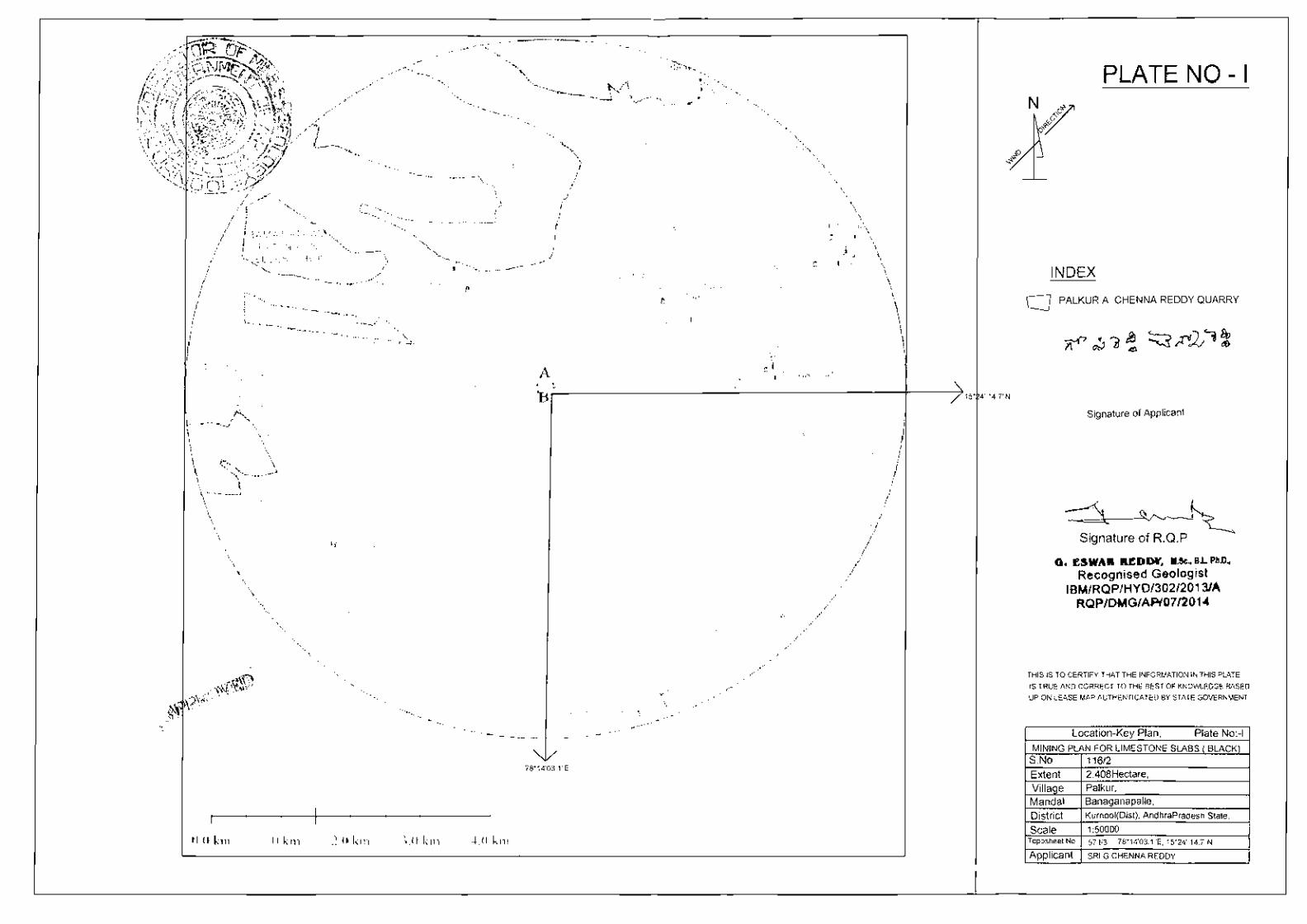
II. Location and Accessibility
The Mine lease area and is bounded in be
falls in the S low Latitudes
/3 (Scale 1: 50,000) WGS 84.
·: . eQ ' tt~·:tdposheet- No. 57 1 -~~~- "c-·e~ .. ::Q~lYmt'Garmin '\' '~'- . .,n :.~ ,, '..,\ •');·.,) i
6'~~..L\\t '\'·':::', .. ~ .. ·· ,j • ' ~ .. ~ ' ...
GCP LATITU~fir) .:i::ON.GITUDE
A 15o 24' 14. 7"N 780 14' 03.1 "E
B 1so 24' 15.3"N 780 14' 10.2"E
c 1so 24' 10.5"N 780 14' 09.6"E D 15o 24' 11.5"N 780 14' 03.6"E
The quarry lease applied area is falls in Survey of India Toposheet No. 57 I/3
( D44A3) and situated towards North West of Palkur Village at a distance of 0. 75
Kms. and can be approached by travelling on a motorable track from
Banaganapalli- Palkur road upto Palkur Village after that by travelling 0.75 K.M.,
after Palkur Village by taking left diversion from Bustand towards NW directly
leads to the applied area.
The details of the area are tabulated below:
District State Village Mandai Sy.
Extent Ownership of
No. Occupancy
Kurnool, Palkur Banaganapalli 116/2 2.408 Hects. Patta Land
Andhra Pradesh
The Sketch approved by the ADM&G Mines & Geology, Kurnool, in favor of Sri. G. Chenna Reddy. is given as Plate No. II.
2.7 Period of Mine lease granted = 10 years 2.8 Infrastructure and Communication
Availability of Water is available at the nearby Quarry site in Bore Well fitted with Submersible Pump. Power connections are
Water available up to QL applied area
Availability of Electricity is available in the village and also using Electricity Electricity in the nearby agricultural lands.
Tele communication facility is available at Palkur (V), Communication which is at a distance of about 1.5 km all cell networks Network
can function in the site area .
State Transport Bus Services ply from Banaganapalli to Road Network Palkur frequently; Private Transport is also available on this
road network.
3

c c· (
c c \
( I
(
(,
l
~
c ( I
t
c {
(
(
(_
(
c l
l
(
l
L
L (
c
Nearest Rail Head
Port Facility
School
Medical Facility
Boundaries
North
South
East
West
High school is··-present in the Palkur village, Junior College and Degree level Educational facilities exist at Banaganapalli which is 15.0 km.
Hospital facility (PHC) is available at Palkur which is 1.50 km from the Quarry site.
Sri E.Subbaiah land The area surrounding 500 m is active with Quarry leases.
QL applied area of Smt. The existing Quarry lease Madhavilatha areas was ascertained from
Patta land of Sri. K. Ghouse the Office of the Asst. Director of Mines & Geology, Banaganapalli, Kurnool
Govt. land & QL area District.
Further good potential exists for the employment of unskilled labour in the
existing Quarries and allied Small-Scale Industries. The area experiences Tropical
Climatic Conditions, General Monsoons are SW & NE with an average annual rainfall of
624 mm. The local day temperature varies from 25.oac (Minimum in winter) to 47.0°C
(Maximum in summer) in the Month. Total Population of this Palkur Village is around
8000 (Source: Census of India - 2011).
III. Details of Approved Mining Plan, if any
No Mining plan was prepared and approved earlier. It is newly applied
Quarry. The Present document is for assessment of the Quarry activity, Reserve
Estimation, Proposed Method of Quarrying, Environment Management Plan
including Reclamation and Rehabilitation measures to be adopted . The Lessee will
approach ADMG for necessary Permissions to Start Quarry Operations.
PART- A
1. General Details of the applied area I Mining Lease:
1.1 Topography
Topographically the applied area is a plain patta land. It is barren land. There is a
maximum relief of 1 Mts f rom NE to SW of the applied area . There is no perennial
4

(
(
(
(
('
\
(
(
c (
(
(
(
l (
(
(
(
(
(
l
A<)5~;-;;..~ .I . ' .·,.. ""l ~ ~ I•") '""'-.· ;',_y\'-
:·/ ~-."~" ~ ··'" \:.:.._~u.~-- ~""' r )\
1:~:1 "' · :· ~..-: :. ;:~~7:fr · ~·~~·:. ~, '\~ ,t~\ water course in and around/~1-~; ·Q~ .:~~jJi~~--p~¥~~\ The surface rain water flows
tr··i 1 ,: .. ; ... :~.-~"'!···, ..... · · .:, ·l )! through the slope of the a~~C~p~}~-.~~lf~:~}}o~~.~ .L~?j the seasonal nala, which is
flowing in SE side of the QL a~J~~;~~J..·iiN;:ho vegetation in the QL applied
area because it is not used fo~~.~~-~~~~:u~:scattered trees are located along ..... ~'/ 'ilh• ~v.---
the boundary of the QL applied area,..-.:.trrere are no public places or important
monuments located in and around the lease area. There are some Quarry leases
around the QL applied area.
Topographical Survey
The baseline is considered from the GPS reading in co-relation with Toposheet
contours, the levels were taken using total station of LEICA with 5 em accuracy
covering the total area.
The geo co-ordinates were fixed using the 12 channel handheld GPS, GARMIN make with
MAP DATUM: WGS- 84
Position Format
Map Datum
Units
North Reference
Variance
Angle
2. Geology and Exploration:
2.0 Regional Geology
Stratigraphy of the area
hddd - mm - ss.s
WGS- 84
Metric
Magnetic
001° w
Degrees
Geological succession of the area (after Saba and Ttripathy, GSI, 2012)
KURNOOL GROUP
Nandyal Shale Koilkunta
Limestone Paniam Group
OwkShale
Narji Limestone
Banganapalli quartzite
A SOOm thick succession of Quartzite, Sand stone, Clay & Limestone
unconformably overlies the Cuddapah sediments in Kurnool and Palnad Basin .
The Kurnool sub basin is in the West Central part of the Cuddapah Basin lies
between the Northern Srisailam sub Basin and Southern Papagni sub Basin.
5

c c· c
~
(
(
c l (
(
C'· (
c l
'(
(
c (
c
(
c (
Owk Clays ~c:ray~·
Narji Limestone
Banaganapalli
Quartzite
Limestone
Conglomerate
Quartzite
Thickness in mts
50-100
15-50
10-35
10-15
100-200
10-50
Banaganapalli Quartzite forms the basal part of the Kurnool group overlies the
Cuddapah group with unconformity. It consists of Dark Red, Grey or Brown Sand
stone, which is course grained and gritty with an impersistant Zone of
Conglomerate.
The above sequence has not been revised; expect that the Pinnacled and
Panyam Quartzites are clubbed together as Panyam Quartzite.
The Narji Lime stones are well developed and have extensive distribution. It
starts as highly siliceous limestone with Pink Colour and thin lenticular lenses of
gritty, ferruginous sand stone at some places. The middle portion is a Bluish grey
high grade limestone, massive and thinly bedded.
The Owk Clay overlying the Narji Limestone, buff white and purple colored
Clay. Panyam Quartzite overlying the Owk Clay is overlain by ferruginous,
occasionally Conglomerate Panyam Quartzite. These Quartzites are forming
typical highly jointed inselberg type out crop with vast and extensive exposure of
low level with gentle dips.
The Koilakuntla Limestone is siliceous and flaggy with intercalated good
quality of lime stone.
Nandyal Clay is uppermost litho unit of Kurnool group, which is purple in
Colour with earthy Clay intercalations, salty cleavage and presence of puckers at
the contact of Nandyal Clay with other formation indicating the effect of mild
deformation.
2.1 Geology of the Lease area
Geologically the applied area occupied by Sedimentary rocks of Narji Limestone
(Fiaggy) of Jammalamadugu Series of Kurnool group of Kadapa Basin. Major litho
6

(
(
c c (
(
(
(
(
(
(
c (
c
,.
~~·. unit exposed in the applied ~~\i§'>~~;.:t6X~:·:·~(,fj~_ggy). At the time of inspection
lithological sequence obse~~:{ntfff,~~r~V:.'~¥isting quarry leased area on quarry face are 0-2.00 ~\Sdi(·'~,:~t~;~:/~ ._0 .,; t· 15.0 Mts Weathered Flaggy
Limestone and 15.0-30.0 M~~'i-f.t~-g~~~~$£o~·e useful for Napa Slabs. These ~.r.:~-.. ·~ !">-. -~-:· • ,.l ;;....., . ( .
Flaggy Limestone beds are blacf<\~i{f.~jg~f.dbinted with good cleavage at regular
intervals. These beds are gently dipping towards NE direction. Because of this
phenomenon it is easy to extract them into slabs of different sizes. These Napa
slabs after polishing can be used in buildings as flooring and roofing purpose.
Both polished and unpolished slabs are having good market within and outside
the state. Some of the entrepreneurs in Betamcherla are also exporting this
material to the various countries in Europe and Australia.
Topsoil: Black cotton soils are covering the Limestone slabs on Top of the QL
applied area with thickness of about 1.5.m to 2.0m.
b) i) Geological Plan: Mining lease area was demarcated on the ground with
reference to revenue pillars. Later the topographical survey of the area was
carried out by theodalite. Based on topographical survey and geological features,
collected from the surface, the surface geological plan was prepared on 1: 1000
scales with 0.5m contour interval and enclosed as plate-3.
ii) Geological Section: By make use of the existing pits data and surface
features of adjacent quarries, the geological cross sections were prepared across
the strike direction as shown in Plate -3 for the QL applied area.
c) Exploration proposed:
The subject QL applied area is surrounded by number of operating Quarries of
C Naapa slabs or Limestone slabs. So that there is no necessity of exploration in
applied area . However, to find out the depth persistence of the mineral it is ....
proposed to drill two DTH holes at the grid junctions of N-70, E-50 (PBH- 1) & N
50-E 150 ( PBH-2). The proposed two boreholes will be drilled to a depth of 35 m
each depending upon the country rock availability during second year. The
proposed boreholes locations are shown as PBH-1, PBH-2 on Geological plan
(Plate - 3) .
7

(
(
('
C'
c (
(
(
(
(
(
c
c (
c
··-Ne:t('J . L<J.~~~, ,!].:_;,.:. -. -~..2 "",: .·. ·)' ./: ,,.. . { . • -~ · t::::!A_\"{~- ,....,
2.2 MINING CARRIED OUT~';:/j~;~·,.:.o~~?f~~~· _ _>;:_.~~\ n rs . • 0 ~ ••• ,. • •• \ ' •. •• ' • .... 0
Details of Mining Operatio l ff"·:..~t· .:~~ ,~, •. :.:..·.'~.<f(\ ~·:, .. ; ·.::)
It is virgin patta land an -~~i~~}f~~·~~s~~ .; q~ is yet to be granted. As the
Limestone slabs (Black) de~~~:£~~~~~~r'to sedimentary activity, raised
10m below ground level of the'-(il'tf<lf!)':.!l'e~:f~t?'a'{jplied area . ' '• ' r/ ', • · • \I l ,. .,~., \,!ill\\ :Y~: .. .
2.3 RESERVES: .... , ... ,,..,_... . .-
Geological traverses in the Quarry and the study exposures in the vicinity of
quarries facilitated to access the shape and size of the deposit in the area. It is a
ground Deposit rising 14-15 M below ground level within the Quarry Lease
applied area. The surface is plain land covered with black cotton soil. Limestone
is termed as thin bedded tormation ot tlaggy Limestone. The thickness of beds is
35mm to 40mm. These Flaggy Limestone beds are black in colour jointed with
good cleavage at regular intervals.
2.4 Method of Estimation of Reserves:
The deposit is found to be scanty regular in shape, the deposit is being worked
out to a maximum depth up to 30-35m in few nearby quarries and the deposit
seems to be occurring still below as per the information gathered from the Mine
owners and drilled bore well data . In this lease applied area Limestone Slabs
(Black) are considered 45°/o reserves in proved category and 55°/o Waste material
( up to 30 m depth as proved deposit including 15mts over burden (OB).
One Cross Section (A-A',) is drawn perpendicular to the slope direction for
profile purpo£e.
Section Area (Sq. m) x Section Influence (m) = Volume of Geological Reserve (Cu . m)
[ Volume of Geological Reserve (Cu. m) x Bulk Density (t/Cu. m) = Tonnage of Reserves
Sq.mts= Tonnage X 13.9 ( 1 ton = 13.9 sq .mts)
8

r
r
~·~TEGORY YEAR SEC:!:AL D~:~~T VO~~~~~-·:..;.J;~""""i.:,..::"'-~-:-· . .-L.-5-.S-. 1-N---,P_R_L~-:.-~-:-I-.O_N W-A-ST-E--.--T-O_P_S_O_Il-
M3 TONS Sq.Mts M3 M 3
r ---l----1-----l---~----1--~----l----+---+---+-----
('
l
290235.2
290235
290235
290235
The recovery of the Limestone Slabs (Black) from the Mine is 45% hence 55% waste is generated.
b) Mineable Reserves
Geological Recoverable @ 450/o
Category Reserves Waste 55 Ofo m 3 (Tons) (m3)
Total mineable 3,86,875
Reserves 4,35,234 55,934
c) Life of the Mine = 4,35,234 Tons I 14015 Tons = 31 Years.
3.0 MINING (a)Open Cast Mining
There are no public buildings, places of importance and historical
monuments. However, the applicant will conduct the Mine operations duly
adopting the restrictions regarding the safety measures as per the
regulations 109 & 127 of Metalliferrous Mines Regulations '1961' and Rules
& regulations of APPCB and MOEF.
(i) Method of Mining (Open Cast other than fully Mechanized I Semi
Mechanized)
The Limestone Slabs (Black) in the Mine lease applied area are exposed on
the adjacent quarries in East, West and North side of applied area. Entire
area is covering with top black cotton soil up to 1.5 to 2.0m and weathered
9

(
(
('
r r c r c (
c l (
, L
A~s.· ·. :'foi:':!!;-.t.f.!,:.:: .. 2\· . . .. .. (""" · ~...:Ji?'-·.· '' •r,i,·'·:.: , , ........ • ,• ~ -~-·- ":.~~-~(,~: ~ :v: _.'!j~-- - .
( . Jit>: • .,.. ~~·----~~~ .. '~:..:\·. \·""-c:l~ --
/i/£.:5,)' f./itf<'*ii;~;\:: ~-..:\: :}~;;~> ; t, ... \1 ··· .,_(p ./' ,i.."i~ • . -.:..;~, 1- •. ;. •. :- .~\\ ·)..\l •~'t. -....v •\ • • ' ·' ~ 11 ~:--... -w~, ·f>-;';·-~:-_·;).'· ., .. , .. 11 "' . ..-:-1f." .
Limestone up to 8mts debttk ,;A ~?~t~fr1'ts ~~~r;t(i } Limestone Slabs (Black) ·~~,( ,• I • ' '· • 'i!!iM,~~ '<~-:: 0 I ~ ''•, tf~ • J
are exposed up to 30mf~~~~ ~~{i-3~f1-F~J*.·f~ proposed to mine the
Limestone Slabs(Biack) by~~~~~,f~mechanized methods, by
developing the one bench of 2 ~th~ith 1.5 M bench width & without
drilling and blasting after removing over burden (OB) up to 15mts. The
development of benches will be maintained @ 60° safety slopes.
Therefore, mining operations are to be carried out in this area in 2 stages.
1) Development
2) Production.
Stage- 1
The removal of Top soil & weathered Limestone (OB) up to 10mts depth
will be cleared in the Mine lease area for the next five years by using
excavator. This O.B can be dumped in Dump Yard NW side of applied area .
Stage- 2
After removal of Top soil & weathered Limestone material of 14-15 mts
Limestone Slabs (Black) can explore by using cutting Machines for required
sizes. The blocks can be separated manually along with cleavage lines and
also separate the Limestone Slabs (Black) and waste material. Waste can
be loaded with Excavator to dumpers directly without drilling and blasting .
Limestone Slabs (Black) are loaded with Labour to Tractors or Dumpers as
there mode of transport to Polishing Units.
Drilling: Not applicable. Explosive Type : Not applicable.
(ii) Production Proposed for the First five years
In the present area there number of quarries in this area. As recent
rules and regulations of DMG & APPCB & APPMC, all Mines should follow
Mining Plan, EC, CFE & CFO, also be noted that DMG issuing the permission
based up on above all required Papers.
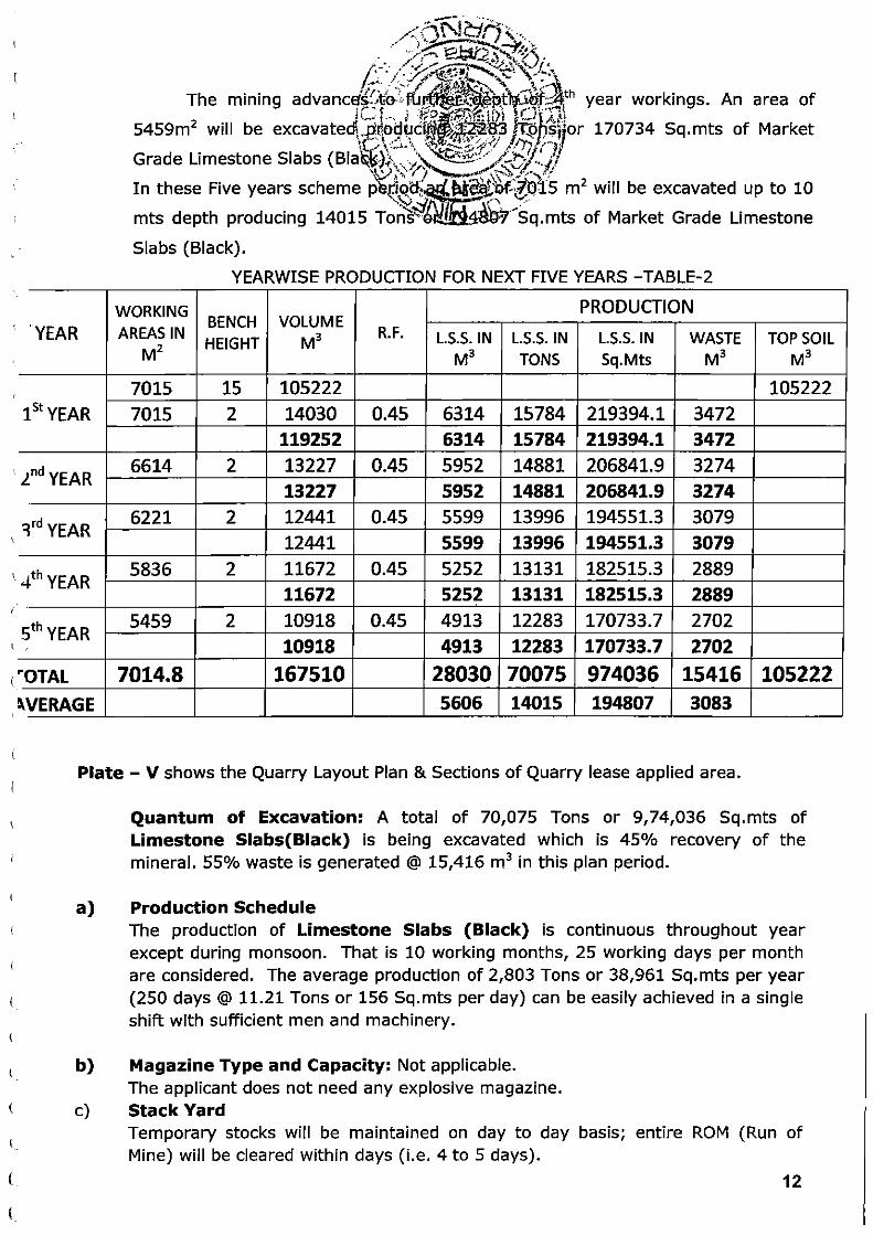
It is proposed to produce 70075 Tons of Limestone Slabs (Black)
during First five years plan period with an average annual production of
2803 Tons or 38961 sq.mts from an area of 7015 m 2. one bench of 2
m height and 0.320m width will be developed during the plan period in
depth of previous year workings successively.
10

c
c (
(
(.
(
(
(
c (_
(
c \.
(
l
(.
(
(_
c ()
G
L
C..
-·-·-~ The 55°/o Waste iW~~R general in Limestone Slabs (Black)
Mine @ 3083m3 ~·-·':-;::'·:··~~~~)~:; ... I • · \~ . .... ,/. • · . .-• ·<.:-.-il~~. "-~~~ tt , :: -
The applicant ~~~?B~s~:}~.~'~?\u~~~arry operations ~~ So~th side of
lease applied area b~~-,~e:eih;tfj~~h~~l01r1W-1o to 650 and E-20 to 1'7s'mts ~.;t;?·~ 6 \ \ :l ·.:'!·~"jj)j!!J. ()! . .
leaving buffer zone ~~)~.,__~pj.!~=~~ ~;ation activity wiU~e taken up in '"""'~t.j .... ) 'P.._j '...,~ :\~~~0; ;
South of the Mine leas~<~l>.~~~g:..;a~ er an area of 7015 ·sq.mts in this '-'!..·.:~: lJ j hi ~ \..). '
five years scheme period after- reffloving OB and then continue moves to
North side of QL applied area.
1st Year: In the first year after removal of O.B up to 10mts depth quarrying will be carried out in the South side of the Quarry lease applied area between the grids N-10 to 6~0 and 1::-20 to 1 /~mts covering an area of 7015 m2 one bench of 2m depth will be formed. The mining advances depth wards. An area of 7015 m2 will be excavated
producing 15784 Tons or 219394 Sq.mts of Market Grade Limestone Slabs
(Black).
2"d Year: In the second year the mining will continue to further depth of 1st
year workings between the same grids covering an area of 6614 m2 in one bench
of 2 m depth will be formed.
The mining advances to further depth of 1st year workings. An area of 6614m2
will be excavated producing 14881 Tons or 206842 Sq.mts of Market Grade
Limestone Slabs (Black).
3rd Year: In the third year the mining will continue to further depth of 2nd year
workings between the same grids covering an area of 6221 m2 in one bench of 2m
depth will be formed.
The mining advances to further depth of 2nd year workings. An area of 6221m2 will
be excavated producing 13996 Tons or 194551 Sq.mts of Market Grade Limestone
Slabs (Black).
4th Year: In the fourth year the mining will continue to further depth of 3rd year
workings between the same grids covering an area of 5836m2 one bench of 2m
depth will be formed .
The mining advances to further depth of 3rd year workings. An area of 5836m 2 will
be excavated producing 13131 Tons or 182515 Sq.mts of Market Grade Limestone
Slabs (Black).
5th Year: In the fifth year the mining will continue to further depth of 4th year
workings between the same grids covering an area of 5459m 2 1bench of 2m depth
will be formed.
11
c
( ' YEAR ( ~
(
15t YEAR
.lnd YEAR
( ~rd YEAR
4th YEAR (
5th YEAR J (
(_ "OTAL
~VERAGE
,;J~-NI ·~;:, .. . /··' ~ Lit, ...... .. .
/ )~ .......... ,.,.~;· ..... . ;:r,--- ;?~,2 : .......... -~" .
/.
,; :·. .. ·..t _,... ~·;-....:·-,'2·~·--i•.J I • ,· . / . .):J,.,...~':JI.l ...... -.:_:: \,• ..... ·~ .~ . : -~ .. I' .. if~ .. .__ "" t :Jl
The mmmg advanc~~~1~~.~~~~~~J?~t~i~f~th year workings. An area of jo_ •• , . . , I ~g~l!'r,\~!ll/ 1 ~···· ' I!'< ~)
5459m2
will be excavated\!~!~2~.~ir~~~~~ .. 4fJ;·~~~or 170734 Sq.mts of Market
Grade Limestone Slabs (Bia~~).?-.... ;\~~: ~~~::iJ..'./1 '~' ) \\. 'f).........___« ..... '{'~~··.··):':
In these Five years scheme p~,i:iqd-:. N-~O.f;~Qt5 m 2 will be excavated up to 10 ..... ~~.; .;::l .· \ /
mts depth producing 14015 Ton'S·~e I v·--sq.mts of Market Grade Limestone
Slabs (Black) .
YEARWISE PRODUCTION FOR NEXT FIVE YEARS - TABLE-2
WORKING PRODUCTION AREAS IN
BENCH VOLUME R.F.
HEIGHT M3 L.S.S. IN L.S.S. IN L.S.S. IN WASTE TOP SOIL M2 M3 TONS Sq.Mts M3 M3
7015 15 105222 105222 7015 2 14030 0.45 6314 15784 219394.1 3472
119252 6314 15784 219394.1 3472 6614 2 13227 0.45 5952 14881 206841.9 3274
13227 5952 14881 206841.9 3274 6221 2 12441 0.45 5599 13996 194551.3 3079
12441 5599 13996 194551.3 3079 5836 2 11672 0.45 5252 13131 182515.3 2889
11672 5252 13131 182515.3 2889 5459 2 10918 0.45 4913 12283 170733.7 2702
10918 4913 12283 170733.7 2702
7014.8 167510 28030 70075 974036 15416 105222 5606 14015 194807 3083
(
c (
(
Plate- V shows the Quarry Layout Plan & Sections of Quarry lease applied area .
c (_
l
L
c L
c c L
l
a)
Quantum of Excavation: A total of 70,075 Tons or 9,74,036 Sq.mts of Limestone Slabs(Biack) is being excavated which is 45% recovery of the mineral. 55% waste is generated @ 15,416 m3 in this plan period .
Production Schedule The production of Limestone Slabs (Black) is continuous throughout year except during monsoon. That is 10 working months, 25 working days per month are considered . The average production of 2,803 Tons or 38,961 Sq.mts per year (250 days @ 11.21 Tons or 156 Sq.mts per day) can be easily achieved in a single shift with sufficient men and machinery.
b) Magazine Type and Capacity: Not applicable. The applicant does not need any explosive magazine.
c) Stack Yard Temporary stocks will be maintained on day to day basis; entire ROM (Run of Mine) will be cleared within days (i.e. 4 to 5 days).
12
t
(
c (
(
c (
(
(
c l
(
c (
(
c (
u
c (;
L
(;
d)
e)
--::::--··~~
/<f\~hr:f ".: . . ' · .. -:;...---·-,, ... -~
Handling of Mineral wi~hi~;~~~=;~i)t;..~~l-~). Limestone Slabs (Black) r=~fe·:~ep~r,a.t~~~m;_;·mo~~er rock by manual and the slope
''""- J g -..· .. ' J j ( ~ ..... ~ () , \ \ ~- ' . . ..... ;
of the ramp is gentle. jrjlr· ~ ( ·.,' ~\~:>:(r~\\1.) ~~::. . . ~-:: Transportation of Mi~e~!~\i~~~ Sf~~~) (Black) from Quarry to yard and to Destination -~\.\'\ .. \ ....... ·-~~- ~- ,!;.:
y~\\_,1. ' ...... .... ~~ . The rough Mineral Limest~J1~,:~~-:. • ~lin the quarry area will be handled by using manual and transpo~c{l~1ons by Tractors and trucks.
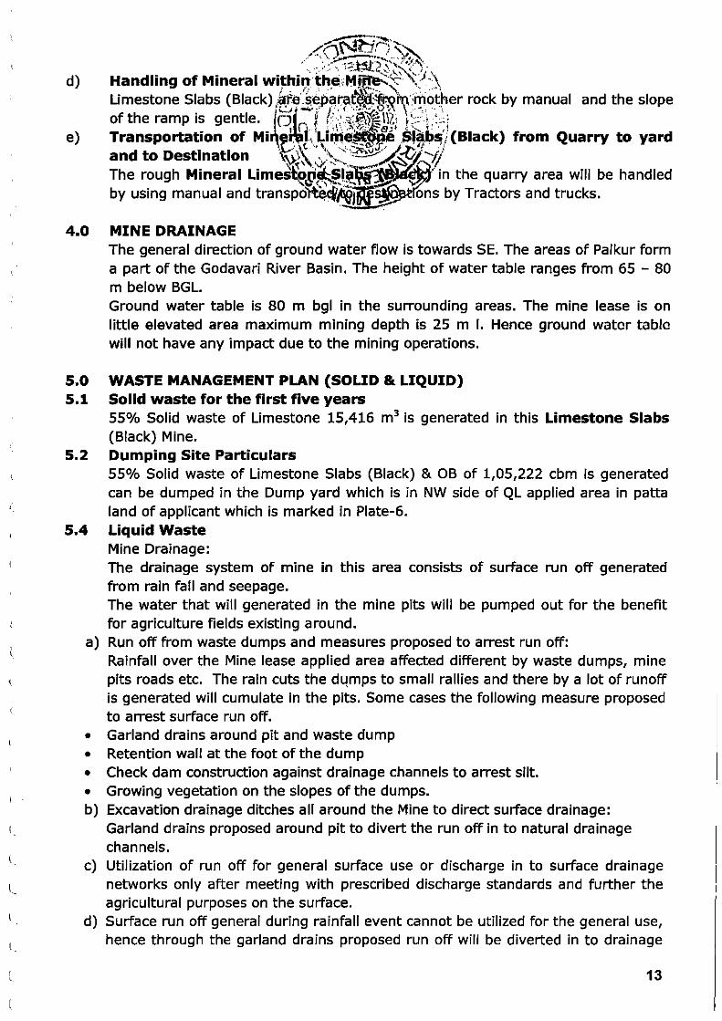
4.0 MINE DRAINAGE
5.0
The general direction of ground water flow is towards SE. The areas of Palkur form a part of the Godavari River Basin. The height of water table ranges from 65 - 80 m below BGL. Ground water table is 80 m bgl in the surrounding areas. The mine lease is on little elevated area maximum mining depth is 25 m I. Hence ground water table will not have any impact due to the mining operations.
WASTE MANAGEMENT PLAN (SOLID & LIQUID) 5.1 Solid waste for the first five years
55% Solid waste of Limestone 15,416 m3 is generated in this Limestone Slabs (Black) Mine.
5.2 Dumping Site Particulars 55% Solid waste of Limestone Slabs (Black) & OB of 1,05,222 cbm is generated can be dumped in the Dump yard which is in NW side of QL applied area in patta land of applicant which is marked in Plate-6.
5.4 Liquid Waste Mine Drainage: The drainage system of mine in this area consists of surface run off generated from rain fall and seepage. The water that will generated in the mine pits will be pumped out for the benefit for agriculture fields existing around.
a) Run off from waste dumps and measures proposed to arrest run off: Rainfall over the Mine lease applied area affected different by waste dumps, mine pits roads etc. The rain cuts the d4mps to small rallies and there by a lot of runoff is generated will cumulate in the pits. Some cases the following measure proposed to arrest surface run off.
• Garland drains around pit and waste dump • Retention wall at the foot of the dump • Check dam construction against drainage channels to arrest silt. • Growing vegetation on the slopes of the dumps. b) Excavation drainage ditches all around the Mine to direct surface drainage:
Garland drains proposed around pit to divert the run off in to natural drainage channels.
c) Utilization of run off for general surface use or discharge in to surface drainage networks only after meeting with prescribed discharge standards and further the agricultural purposes on the surface.
d) Surface run off general during rainfall event cannot be utilized for the general use, hence through the garland drains proposed run off will be diverted in to drainage
13

(
(
(
(
(
(
(
(
l
(.
(
(
l
l
(
(_
c. (J
L
L
/::~~A,· :'~ :. ~~6.C:$• ~~~)(\
~f_L /~~-; - .. r. . ~'\~\, <\;_f~ .. (!)f. !.( . 'I-' • ;-- . 'itr,;._\ \~~--· -~ ; ... . O t < t ~~~~ 't ~ ~;h .. ·~'~ ... '
network. Napa ~lab~ m~nes _g~( ~~ · · ~~i1~~~~1~~~p).lutants or toxic substances; hence, no contammat1on 1s e .e~~e~,:~:·.r:;~,P~)sl ~t_.atton}'
e) Treating waste water to obta i~.;K(}e~ir~~~::'l~t~.Y·:<'for industrial use as may be requl·red · '""0. -! ... \·-~:::"\;.-.. , "1',.>··. ·
I . ........ ~ ,.. • ...,..,.,. ,~'\ '
No industries exist in the vicinity o .. - ~~Min·~ 'fease area. Hence, no treatment is required for the run off.
6.0 USE OF MINERAL AND MINERAL REJECT
7.
8.
The district has significant resources of Limestone Slabs (Black). This mineral can be used as Napa slabs. In this Kurnool District more number of Polishing Units. So that this mineral can be supplied to the local units. These Napa slabs after polishing can be used in buildings as flooring and roofing purpose. Both polished and unpolished slabs are having good market within and outside the state. Some of the entrepreneurs in Betamcherla are also exporting this material to the various countries in Europe and Australia. Processing of ROM and Mineral Reject No processing is required. Only dressing of the Mineral and screening to the required sizes as per the market demand will be produced. Others (a) Site Services The Lessee is well established in this Mine Operations since long , So Permanent Office, Rest Rooms, First Aid Room, Shelters and Water for drinking will be provided in the Quarry premises on make shift arrangement. (b) Employment Potential A total of 14 persons shall be engaged to carry out the various operations at the QL area. The man power required for the mining operations shall be as per Table given below.
s. Category
No. of No. Persons 1. Foreman 1 2. Supervisors 1
3. Tractor/Tipper
2 Operators
4. Helpers 2 5. Machine Operators 4 6. Unskilled Labor 4
Total 14
14

r l
(
(
t
c (
(
(
(
c c c (
c (
(.
L
c c (.
l
(
L
<._
(
L
L
l
8. i)
ii)
iii)
~·<~:)N~ii~ / ~.. 't::!~:.-Y.~" . • , ? •, ....... ..., ~/('\. / _.. . ',_..~, ..... ,...,.,;~··· :s .· -~\
PROG /~:i~.-%_J:;~~Ef, :~,. (~~~~1PLAN \~;~~J-.-:-·-.\ ._;:~~t;_:'l .· ~;1P)}
ENVIRONMENTAL BASE '~(~E .~~-FQRM~!~~~1,/ Existing Land Use Patter~·;~{\~~~ ):·\~·~\1:-'~~1· The subject area is a waste,~fa~~-- -~· being used for grazing due to mining in adjoin area some pa~~~bject area is also covered by the pits. Water Regime There are no perennial water sources in and around the QL applied area within 500m radius. The rainwater flows through the water course of the QL applied area and joins to seasonal anal, which is running in middle of the QL area.
Human Settlements The following village are located within 5 km radius of the QL applied area. The population, distance and direction of the villages with respect to QL are given in the following table .
S.No Name of the village Population Distance Direction KM)
1 Devanagar 1000 0.4 NW
2 Palukur 8000 1.45 NE
3 Cheruvupalle 800 2.75 East
4 Ramakrishna Puram 450 1.5 NW
5 Govindinne 550 4.5 West
6 Venkatapuramu 350 4.8 South
iv) Public Buildings, Places & Monuments no Public Building, Places of Worship and Monuments with in or near by (With in 500m distance) the QL applied area.
v) Sanctuaries and eco-sensitive areas No Sanctuaries and eco-sensitive areas are seen in and around the Mine lease applied area.
vi) Flora and Fauna The subject area has some bushes and no tress. There is no report of existence of wild animals in this region.
2.0 Environmental Impact Assessment A. Landscape changes
During the next 5 years 7015m2 of the Mine lease area will be reduced by 25 m. The Mining will alter the shape of the land with a large sliced pit. Aesthetic Environment There is no aesthetic environment prevailing in and around the Mine lease area.
15

(
(
(
(
(
(
(
(
(
L
(
(
('
(
(
(._
(
c. (
(
c L
(J
(
c c
6\'Jt:1r1 ··,_ ... ~·-. ..... '-... ~ -. ~. > :·,,. Y.~~'.
/ f' .. ,._ . •<:; • \ • ' · (" ' ' .;·. . ~, - .. -... ·-~·,\ ... ·~.1; ·.
J.:.. •. 11'"'·-:< ··- ~. ,, ,.... . 'f.~ ~.,.~-~ "' ; ''•. . .. .. .. ..... ~~-~~~.~\-~"' :.. ' l. ':". ~ .. -.. !~.... ~~ /.< t-~'·''-i•··'' . ''. ' .·. ~ \ I : I ~ J'_ .. t:;;,',."'. :,o- r,.o:. ·-.,.' .. · ~ ,' c\ I ~ )C I ..
• ,... .__ t_• j ,. • ::U '._i~ t ·, ,•.- ', : •• ' ,, • . .... Sol. I and Land Use Pattern ,, _ _, · 8 {'-1~·.1:.:.••.:.- : ,_··:·: \'•"._ ':..-Jt, .. ,)z, , i;j! .• ·. ) ;'~t . _:v•l ·,\·.~ \ ~ I ' ' ·' •
The Q.L applied area has 1-2m.-:;9:~~dlf~-~o.y~_r.~ · However top soil will be used for \{ l \:C.;\ -. . ... . \.· · ·· roads. \Q:\· \ · · _ . :{v~·, · . :· .. .
(b) Air Quality in Environme~~~()·~~:;r~~:::::~~;.:~·~,':~-~-:· .. · · Air quality is good but at quarries i~1J!~i.~it~ ··dust, due to haulage on the road, etc., but it will be within the permis~e,·· lrmits· by sprinkling water on roads and covering the drill rods with cloth. Air quality will not be disturbed, as the Mining is very limited.
Highest air pollution due to dust is caused during loading operations and during transportation. The dust generated is moderate unlike crushed stone quarries. The dust is not siliceous, and is not harmful. The noxious gases generated due to diesel burning vehicles and also generated during blasting are however conGiderable but due to the huge level!:> of dilution with !:iurrounding fre5h air they become non-dangerous. However as a precautionary measure the workers of the Mine wear a protective nose mask. The only silver lining in this pollutant's quality is that this does not contain respiratable size of dust as defined under Mines Act-1952. That is the reason that there are no cases of any lung diseases to the persons working.
AIR QUALITY
Base Level Allowable Level
SPM = 140,ug/m3 360,ug/m3
RSPM = 60,ug/m3 120,ug/m3
S02 = 40,ug/m3 80,ug/m3
N02 = 40,ug/m3 80,ug/m 3
CO = l.O,ug/m3 5.0,ugjm3
Air quality is good but at quarries it is filled with dust, due to haulage on the road, etc., but it will be within the permissible limits by adopting the following: • The dust rising due to drilling will be controlled by covering the drill rods with
cloth; dust extractors will also be employed. • Dust suppression on haul road with sprinkling of water with chemical additives. • Proper functioning of dust suppression arrangements in the equipment • To periodically provide dust masks, or towels for the workmen to prevent
inhaling dust laden air • The speed limits of the trucks will be dictated and overloading of trucks is
totally avoided which will prevent 50% of dust rising on roads.
(c) Water Quality Operations of Limestone Slabs (Black) quarries in general do not contribute to the water pollution much. This is due to the reason one being the material is geologically Igneous in origin. This is the reason why the water does not percolate directly into the earth. Rather it tries to travel through the cleave planes or the
16

(
c (
(
(
(
(
(
(
(
(
c (
(
c c
l (
.{ ' /~~~~~~~~~~\ t:~.l~~· .I' ·:~Mr~:~lY.;~~ \· ft\ \ O\ .,.:.:!·~··" ~ .·~··""';.' .. -~~ . ()>\ u· •. ~~·~ ·:.)£. __ J t·t''f'~:·,,_r~1"":(..:-: :L.'\
11· 0~.1] ;.
: r't\''\ __,.. ; f · \,,,1~ '"'·'.C::~· • . I <-' .~17 :. ~:.1 _ -- ~ ~ 1 ... _,\·~ ... ~r ... ~~/·: · '--· f' i'
joints. The site specific rea.S:-q~ ~fq·~\!GW.M.at~B-PPJ!'~~on is that, the floor exposed is impervious whereas the dire<?;tion;~-pe-t-p~Rdi:c.· ~1.~-Rtd/the floor is pervious. Thus there . "'£:.1 ''" ..../.. \ \ ',\\\~_.-- A"-9 will not be any direct contamln~~@~~ttie:'~<aeG. " dam construction arises based on the topographical condition of the ·a·rea "~ ;:j
No water course is passing through the area excepting run off streams during monsoon. The Mining of Limestone Slabs (Black) has no adverse effect is anticipated on the water regime in the area.
IS 10 500- 1944
S.No. Characteristic Desirable Maximum Permissible
Limit Limit
1 Colour 5 25
2 Odour & Taste Un Objectionable
3 Turbidity 5 NTU 10 NTU
4 pH Value 6.5 to 8.5 No Relaxation
5 TDS 500 mg.per
2000 mg.per ltr. ltr.
6 Total Hardness 300 mg.per
600 mg. Per ltr. ltr.
(d) Noise Levels The rock breaking, haulage and the drilling of boreholes generate noise. However,
the probable noise level will be within the permissible limits and will not cause
harm. The lessee will provide suitable protective gear to the workers for
minimizing the noise pollution and the machinery will be well maintained.
The Noise produced due to machinery operations and transport vehicles not much
but for the extraction activity. The noise levels of machinery can be categorized as
noise due to static machinery like excavators, crushers and compressors. Another
category is noise generated due to moving machinery. Noise due to tippers, drills
comes under this category.
The noise levels for various activities are
1. Compressor - 84 to 98 dB (A)
2. Tipper Empty - 88 to 91 dB (A),
3. Tipper Loaded - 95 to103 dB (A)
4. Proclain - 90 to 96 dB (A)
17

(
(
(
(
c (
(
(
(
(
(
(
c (_
c
c l
L
PERMISSIBLE NOISE EX~~ <I '~U:~;ERENT PERIOD OF TIME IS
/: . ' ' . . • \ ! , _ '
1 100
105
110
1/8 115
The rock breaking, haulage, machinery and the drilling of drill holes generate noise. However, the probable noise level will be within the permissible limits with in 100 d B (A) and will not cause harm.
• The machinery will be maintained properly to reduce the noise • The protective noise reducing gear like earmuffs, the company will provide
earplugs. • Proper maintenance of equipment by regularly lubricating all moving parts. • Rotation of job of the persons to reduce the average dosage that they are
exposed • Usage of High-Carbon grease for the moving metallic contacts instead of
ordinary grease will reduce the noise by 20 to 30%. The proponent intends to use this method .
• All personnel must wear PPE (Hard Helmet, Shoes, Gloves, Ear Plugs) in the Mine area.
(e) Vibration Levels There will not be much vibration due to Cutting machines.
(f) Water Regime The area is not a hill. The Mine operations extend below ground level. The water
that is due to rains settles below the Mine. In most of the cases the quarries do
not operate during rainy seasons. This is due to accumulation of water. Most of
the water slowly seeps below the ground and enters the water table. This is the
reason that the local bore wells have full of water during all the seasons. On the
other hand the areas devoid of quarries are found to have low ground water
levels. In particular no additional steps are needed to arrest any water pollution.
18

c \
(
c (
(
('
(
c (
c (
c (
c
(
(
c
c
. .-:. ·: \Ci\'1_~ ~
;_./ :.$;~~~'\ ;.:_· .. . : ·:·F~~ .. -· .. ~~~,
/!.·~li ·'.:/l 1:t~:~& @\~)\ (g) Acid Mine Dr~inage{C;! . ~~t~.£f~i~ ~~~~~ : :~) (~) Su~ace subs•~ence~{;\ ~o{~~P,M~~RJ~,~~~~-·:· ~ (1) Soc•o Econom1c Envlr()q.me~>-S-:: ·-k~···,;'f!.~ ..... : The main occupation of villag~~'£~~~~{~~f~£':M'iile Workers and sheep raring.
The commencement of Mining ad1~iy : in this ·area improved the socio-economic ........
status of the local people by creation of employment and paying taxes to
grampanchayath.
It was observed that most of local inmates of villages within an area of 10 km
around the project site are involved either in cultivation, or in petty jobs. Most of
their children are college going or school going. Some of them are in business in
nearby towns. Most of the persons are connected directly or indirectly with the
local cultivation of paddy, It was explained that some persons have business. The
present Mine activities will have some positive and some negative impacts on the
local social regime. They are as under.
Positive effects:
1. The locals get the employment. Some persons are found to be buying trucks
and renting to the Mine owners.
2. The locals get some job opportunities and especially the skill levels increase
due to their exposure to the machine environment.
3. Due to higher earnings their general status of living improves.
Negative effects:
1. The dust if not controlled can harm the inmates.
2. The worst problem is due to dust generated during transport and the main
roads can be seen with this menace.
3. The rate of truck transport has increased the rate of accidents to locals and the
area is found to have increased number of accidents due to careless driving.
4. Although the higher Noise levels may not harm persons working in Mine, they
will face the problem on a longer run.
(j) Occupation Health and Safety The Mining in this area does not involve any hazardous methods. The Mining is
simple and open cast mining method. In this, the possibilities of small injuries are
anticipated. The lessee is providing First Aid facilities at Mine site and Office
room.
This also consists of issuing PPE (Personal Protective Equipments) to all the
persons working, and those that are needed for the site specific operations. The
following PPE are proposed to be distributed.
• Helmets once in three years as needed under Mines Act
19
c
(
('
(
(
('
r (
(
{,_
<...
(
(
c (
(
(
(
c c c (
c
l
L
(_;
(.
(
(
3.
....... ....... ;~~ ..... ~ .... \· t.t~:;;'~ . -~---~
;~··\\' ~~· --~··· : :t~(.·~, .. ..
/ < '· . . ;··~-~~: ~~~~~~·~~" '~~~ ·'*' ;)if:::, . .)~ ... . ·,~ .. ... , :i: ... ~~\ ..•.. -., ~,. -.. ·~ ~ ··~ . . ..< }. -~~-:-~~~- '~~\ . I ~ c; ' • •,\ .• • ;·!,...., ,.~·~ ,_, ~~
• Safety shoe to all thef:-~n,l,~.i9v~~*)~i~~}l~y~as per the same statute .
Safety goggles to thJ~oHf(~p~~\~t~:~~n1'J· "t:r~~er operators which is a site , ' .. •-~- -~~-0~r .. ~,~.~I:Y ] f:.}] -~ ~· •
• •
specific requirement. ~\. ' ···; ,_ ~%_~/ --~~ Nose masks once two t{j .. -
1._, A · ·~~ are the cotton thin towels)
Other step to improve safe~- {t~o inculcate the safety culture
among the persons working.
(k) Historical Monuments
No historical monuments are located in and around the lease area.
(I) Bio-Diversity
Agriculture
The Mine lease area is an operating mine and far away from agricultural lands.
Therefore, there is no adverse effect on agriculture.
Forest
The Mine lease area is not falling under forest zone. (However, the lessee is
proposing to undertake afforestation in the area) .
Vegetation
The Mine lease area has operating mines, with an exception that, small shrubs,
herbs and thorny bushes have grown along the boundary of lease area where
some soil exists.
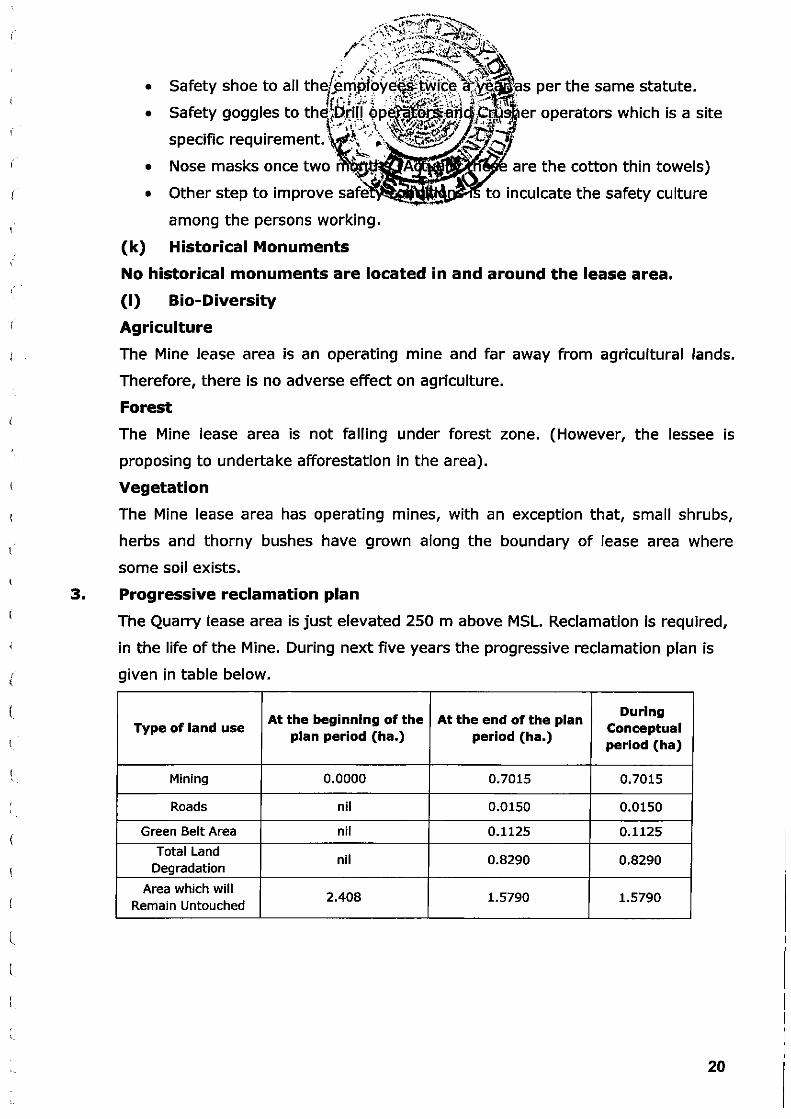
Progressive reclamation plan
The Quarry lease area is just elevated 250 m above MSL. Reclamation is required,
in the life of the Mine. During next five years the progressive reclamation plan is
given in table below.
At the beginning of the At the end of the plan During
Type of land use Conceptual plan period (ha.) period (ha.)
period (ha)
Mining 0 .0000 0.7015 0.7015
Roads nil 0.0150 0.0150
Green Belt Area nil 0.1125 0.1125
Total Land nil 0.8290 0.8290
Degradation
Area which will 2.408 1.5790 1.5790
Remain Untouched
20

c (
(
('
c c ('
(
c (
' \
(
(
(
c. c c c c (
c c (
u (
c (
(
(
4. Mined Out Land Land ollows Use Pattern of the Mi~~;~-~e:.a '~lJ.i~~ ~-)!~ years will be as f
\ .. ' '.; < .. u~ \.~:_:.:;:~~/ !- ~j~ )f) Aft~\ "\ .. ·~;p ~-._,.._ '·-· ---.· ' '-· >~ ·- ' / .... ...:..~ ( . \. . ._ .. :- ,: :·~.. ""'' <s.;;;, -·· ~t
HECTARES
Active Mine Brok~~;~~~:kl~.t~(rg/,.. -!(!}:' 1 ::iA.Iti..l
0.0000
Area .,_, .... _"\1,11.1_-:f ......
To be Broken 0.7015
TOTAL 0.7015
7.5 M wide safety zone 0.3878
Existing Out side Dumps
applied area Proposed
Infrastructure (Mines Office & Site Services) 0.0150
Roads With in pits
TOTAL AREA 1.1043
The land that will be broken in the successive conceptual periods (the Life of the Mine is anticipated to be 11 year as of present). LAND USE The on-going mining and the downstream activities have covered the lease hold for about 0. 7015 Hectares as detailed below:
1) Working Pit 7015 m2 0.7015 Ha
2) Stock Yards Within the mine pits on
Nil temporary basis
3) Buildings Nil Nil
4) Ramp Area, Internal
Within the Quarry Road Ways
Proposed for reclamation of land affected by Mining activity during and at
the end of mining
No reclamation is envisaged in the life of the Mine as there are mineral available
in further depth. Hence, no reclamation proposals are made.
Plantation Programme
The Mine lease area is scanty suitable for plantation as entire area is rocky. There
are absolutely no chances of any tree growing in the Mine area. However it is
proposed to plant a few trees in the nearby village area in the place shown by the
village panchayath .
21

c (
('
(
c c ~
(
(
c
c (
(
(
c c (
c l c (
c. r ,
c D
c r
5.
6 .
7 .
8.
9.
~ .. :··.~·-- - ~· ,.of.;.:•, ~.1"
/.'::~.!~. ' :s . s;!·: /' :,,i"·~,., ~ ' ~.~
All around the Mine t hat is i~~~l{~'~;' . ·, t . . <;t ~ ~of 7.5 meters as per AP PCB
and MOEF rules, around the[~~r~~ {~ . :~-~ ;~jllf~ frlipde to grow plants with local , ~ . :.\ ·':: . ~ :-~"'t •. Wf{J?1? (;~'!JH11
arrangement of pits filled wit~~ .. ~.~~.~t.:t~~g~~:~)~ged that. around 10 ~lants will
be planted and taken care of l fl.~~g~t-f:?-P' area available East sJde of the
periphery will be sufficient for arou~'~J~· Although the area in general is fertile the location where the Mine is situated is
partially rocky. However trees like Neem, Ashoka, Mango, and local species Peepal
are found in and around. Therefore these three species are planned for plantation.
Maintenance of these plants that are grown in the buffer zone will be taken care
by the Mine management. The plants that will be grown in the village will be taken
care by the managemP.nt, in r.oorciinntion with thP. VillngP. rnnr.hnynt members.
Top soil Management
Topsoil will be stacked separately in 7.5 mts buffer zone and grass & plants
will be grown on soil dumps. Finally the soil will be spread on reclamated
portion of the pit at the end of the mining and the reclamated portion will
be used for plantation.
Tailing Dam Management
No dams are available in this area.
Disaster Management and Risk Assessment
Since it is a small and shallow open cast mine there are no chances for
disaster. If any disaster occurs the mines manager and mine owner will
take all statutory actions.
Care and Maintenance during temporary discontinuance
Safety & Security will be provided during temporary non-working of the
mine.
Time Scheduling for Abandonment
As the Mining in the lease hold is active proposal of abandonment is proposed in
next 5 years period.
22
(
c (
(,> .....
(
c
r
(
c
\
(
\ (
(
c c c (
c l c c c L (
(
c ()
(
c (
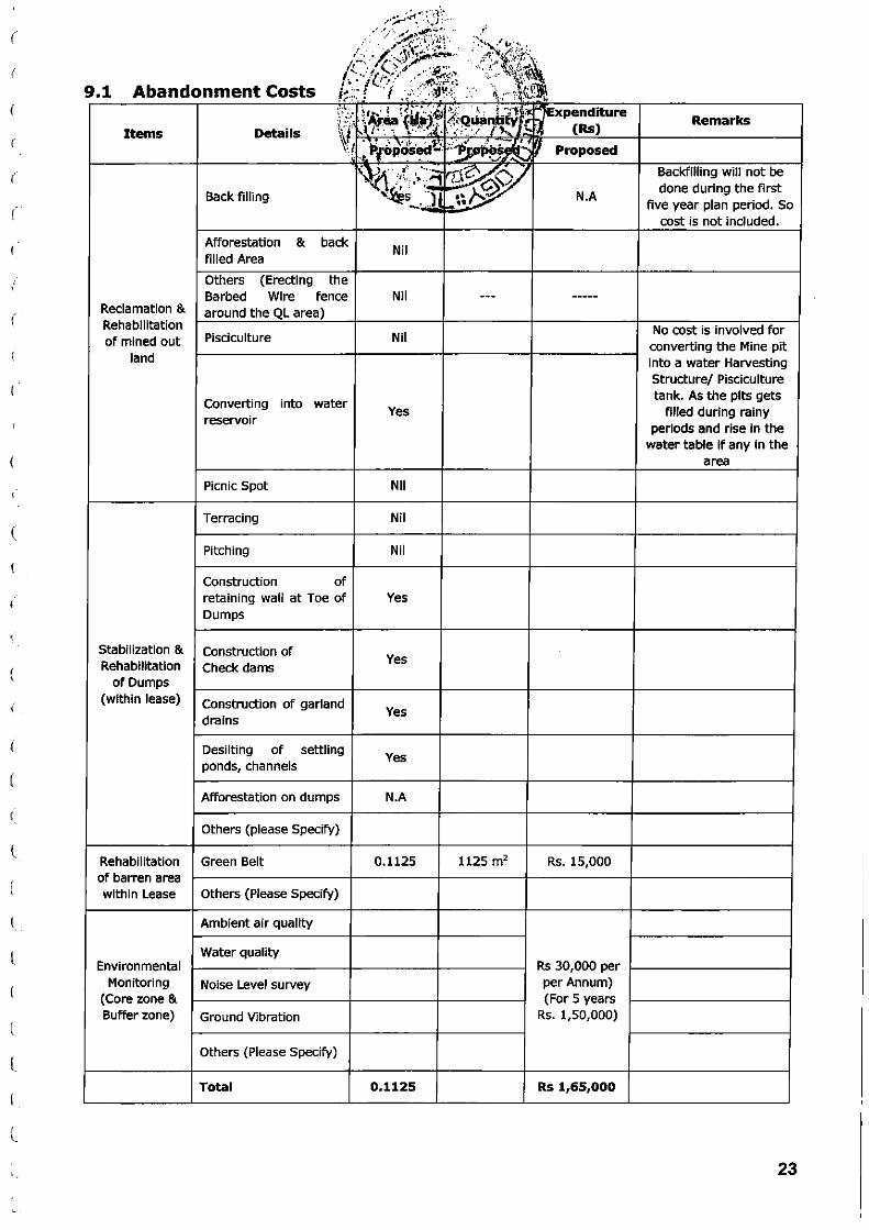
9.1 Abandonment Costs .. . .. .. ' · · .: ' ':·:·_- ~ 1A, · ! ~<~ ···:~ }.· · '= t.iJi!;.' · 7expenditure ;' ::,,; · ·l /ea { . ~J.:l .~Qu;~~tt:., f.t ~ (Rs)
Items Details ;~ ' . .... • : ,. ~f. • . ., ('•" . / .... .
~:r ~~ ~f6~~s~~ -:~o'/J~j!~~ Proposed \~) ., ,., ··· ·~
?~)>/ ~~ '''': ·• ·""1 Back filling '~~· ·.lj ... ,, ... N.A ., .. '""- .l ••
Afforestation & back Nil
filled Area
Others (Erecting the Barbed Wire fence Nil --- -----
Reclamation & around the QL area) Rehabilitation of mined out Pisciculture Nil
land
Converting into water Yes
reservoir
Picnic Spot Nil
Terracing Nil
Pitching Nil
Construction of retaining wall at Toe of Yes Dumps
Stabilization & Construction of -Rehabilitation Check dams
Yes
of Dumps (within lease) Construction of garland
drains Yes
Desilting of settling Yes
ponds, channels
Afforestation on dumps N.A
Others (please Specify)
Rehabilitation Green Belt 0.1125 1125 m2 Rs. 15,000 of barren area within Lease Others (Please Specify)
Ambient air quality
Water quality Environmental Rs 30,000 per
Monitoring Noise Level survey per Annum) (Core zone & (For 5 years Buffer zone) Ground Vibration Rs. 1,50,000)
Others (Please Specify)
Total 0.1125 Rs 1,65,000
Remarks
Backfilling will not be done during the first
five year plan period. So cost is not included.
No cost is involved for converting the Mine pit into a water Harvesting Structure/ Pisciculture tank. As the pits gets
filled during rainy periods and rise in the
water table if any in the area
23

\.
(
(
c
10.
11
~G:R 0~Financial Assurance: Not appr .. : .. . ~ · . ·;\\JMlr"' .~~
/u.,····· \ ~'4' lf'y.l<.~ lb. . . ,·~qf~,~~·~· .~~ . J~·'\, ~. •
Cert1f1cate: 1::·::1//:J. . ~iu~"~f~~· ... · '-;\~~\. Certified that the above mentiq~;e.9 , i . ·~t:~~~#A tah~~ the Mine Closure Plan for
Limestone Slabs{Biack)ocher J1
J·~}~ .. ~,. l'i61:~b1 ~"~4.Cia1Hects in Sy. No.116/2 of
Palkur Village, Banaganapalle ~~~~~~-~~t~;~$,i~~~~l, Andhra Pradesh State. ' 'JtLL> ~....-.- , ,:... .. ,.~ f'~~
All statutory organizations, courts·· ~.f:~~;L~~~ taken into considerat ion and
wherever any specific permission is required, the lessee only will approach the
concerned authorities.
All the measures proposed in this closure plan will be implemented in a t ime
bound manner as proposed.
\ 12 PLANS & SECTIONS
(
(
(
\..
(
(
c c,
(
(
(
(
c c (
(,
(
c. c (
c {
The plans and sections are enclosed.
Applicant
~~~~~ ~~~~ 1\ ~ "~ r;-
( G.CHENNA REDDY)
\hts Mnnng Plants Approved subject to th~.
CondittOns/Sttpulations ind~c~'~C tJb,~tl1~ ~ ~ i~ I Letter Noeu...le~~ oo~>P - ~
P\an Approva .. ~ 2 CL /."fl~ \rJ
Oate<CX~:: •• £..;' j
G.ESW AR REDDY M.Sc., B L.,Ph D., RQP /GEOLOGIST,
G. IESWAB REDDr. M.Sc., B.L.Ph.O., Recognised Geologist
IBM/RQP/HYD/302/2013/A RQP/OMG/AP/07/201-4
24

l
(
(
(
(
(
(
(
I
(
(
(
(
c c l
(
l
(
(
L
G
(..
L
L
(
25

c (_
("
(
(
(
(
'(
('
(
(
(
(
(
(
(
c c l
c c
l
l
l
l
(._,
(_
c c
- ;.·i;l~~;~f~:-·~ ~'.f,· '· \\ ~:,""\<-~~ /,t.P;':-,,
··1' / ' .: ... ;·:.:.I '\·! I ~'ilr:-~-·~: .. • f';, ......... ; '.'· , ;,~~\ ,-. . . " . ~!· · ··~-,- ~,.._ . tti! l '- ~· ... •. -~ .. ,'.J...~. 00
//)>.'·.· ... ·· .... '1\.Nl~t . . . £~ , ,.(~~: . {/}.1.. -.; .. ·. . . .•... ,-•. · .r~ -~ \ ~\, ,1 >'1• ·:r.·::· . . · -~ ;· .. ~ :~" . :1~ . !.?~:,!;~~ {
.'i,.,j.{rc . -~'-··Y t\ ·' •\, ·i ·\':'
· ,')L$OVERNMENT.~f.:~~~DfiRAt~ADESH \(.f>..ePARTMENT 0 1IpJES~AN(;) GEOLOGY
(OFFICE OF THE DEPW~;~~~~~R .JjJi~;N·E-~~EOLOGY, KURNOOL REGION} ~ \' . . . . , . . oQo: .. , . ~--,-~ ..
Notice No.258/Q3/ 2.017 \ ·::.'· >'\ :' .. ~.. . . -~ . .,~t·'t-::~:.:;1/ DATED:02·02-2017 ~~~ . > : -'\ \ ~ ... ~!':""' \,~::.:: .
'• 'lf, ,J \ ·.• ._ '~'~ ._ A .... :., •
Sub:- MINES & QUARRIES '~'!A~Wii~tlo~ ...fi!r .:.gnmt of Quarry Lea~ for Limestone Slabs {.BJack) over· f=~n extent 9f 2.~4otr' Hectares in Sy.,..o:116/2 (Patta land) of Palkur (V), Banaganapalle (M), Kurnool District - A/o~ Sri G. Chenna Reddy- ~proved Mining Plan alo·ng with consent for Establishment from A.P Pollution Control Board and Environmental Clearance from Ministry of Environment .& Forests as per Environment Impact Assessment Notification through 5.0.1533, dated: 14.09.2006 -Called for - Regarding.
Ref;- 1.) Q.L application dated:16.11.2014 received in office of the ADM&G, . Banaganapalle on 17.11.2014 from the applicant. · ·
2) Proposals F.No:7133/ QL/2014, dt:.:Nil-• of the ADM&G, Banaganapalle received by this office on 21.01.2017.
-oOo-
Through the reference 1st cited, Sri G. Chenna Reddy has applied for grant of Quarry Lease for .Limestone Slabs (Black) over ~n extent of 2.408 Hectares in Sy.No:116/2· (Patta land) of Palkur (V}, Banaganap~lle (M), Kurnool District for a period of 10 years. The said Quarry Lease qppficatlon was received by the Asst. Director of Mines & Geology, · Baryaganapalle on 16.11.2014. ·
Through the refe.rence 2nd cited, ·the Asst. Director of Mines and Geology, Banaganapalle has submitted proposals and recommended for grant of Quarry Lease for Limestone Slabs (Black) over an. extent of ~.408 Hectares in Sy.No:l16/2 of Palkur (V), Banaganapalle (M)1 Kurnool District in favour of Sri G. Chenna .Reddy for a period of 10 years subject to the satisfaction of A.P.M.M.C. Rules, 1966 and subsequent Govt. instructions issued from time to time. ·
After careful examination of the proposals of the Asst, Director of Mines & Geology, · Banaganapalle , it is decided in principle to grant a Quarry Lease for Limestone Slabs (Biack)over an extent of 2.408 Hectares in Sy.No:116/2 of Palkur (V), Banaganapalle (M), Kurnool District in favour of Sri G. Chenna Reddy for a period of 10 years, subject to submission of Approved Mining Plan along with consent for Establishment from A.P Pollution Control Board & Environmental Clearance from Ministry of Environment & Forests as per Environment Impact Assessment Not!fication through 5.0.1533, dated': 14;09.2006.
However, the approved Mining Plan shall also reflect the restrictions to be adopted by the applicant while conducting quarry operations due to the existence of any structures, railway line, roads, water bodies such as river, lake etc., and the stipulated distances as per the various Regulations prescrib~ under Metalliferous Mines Regulations, 1961. •
In view of the above, Sri G. Chenna Reddy is hereby requested to submit Approved Mining Plan along with consent for Establishment from A.P Pollution Control Board· & Environmental Clearance from Ministry of Environment & Forests as per Environment Impact Assessment Notification through 5.0.1533, dated:' 14.09.2006 for the proposed precise .area for grant of Quarry Lease within period of (6) months from the date of issue of this ·notice to consider for grant of Quarry Lease for Limestone Slabs (Bfack). If the applicant falls to submit the Approved Mining Plan within the stipulated period, it wilf be presumed that the applicant is not interested in getting the Quarry Lease over the subject area and further course of action will be initiated as per the Rules. A copy of the surveyed sketch showing the precise area of 2.408 Hectares proposed for grant of Quarry Lease in ·favpur of the applicant is enclosed herewith. ·
En~ls : As above.
To Sri G. Chenna Reddy, S/o G. ~osi Reddy, R/o Palkur (V), Banaganapafle (M , Kurnool District.
Copy to the Asst .. Director of Mines & Geology, Banaganpaalle for information.
26

r
(
(
\.
(
c (
(_
L (
c (
(
(
L
l..
c (_;
(
(.,
c...
L
GOVERNMENT OF ANDHRA PRADESH
DEPARTMENT OF MINES AND GEOtOGY
CERTIFICATE OF REGISTRATION
AS QUALIFIED PERSON TO PREPARE MINI NG PLAN
[Under Rule 14(2) of Granite Conservation and Development Rules 1999]
*****
Sri G. ESHIA.R REDDY, Slo G Pakkiri Reddy, Rio No: 13-2-155-1.
Pavananilayam, Near R. T.C. Bus Stand, Ananthapuram, whose photograph and
signature is affL-red herein above, having given evidence of his qualification and
experience is hereby granted rene>-val of recognition under rule 14(2) of
Granite Conservation & Development Rules 1999 as Qualified Person to
prepare Mining Plan
Registration Number is : RQP/DMG/AP/07/2014
This Recognition is valid for a period of 10 years with effect from
22.12.2014
This certificate will liable to be withdrawn/cancelled in the event of
jitrnishing the wrong information /documents in the Mining Plan submitted by
him.
Place: Hyderabad Date:)'}_,.. . 12. 2014
I
27

l
(
c c (
c ('
c (
(_
(
(,
c c c (
C
c c c c c L
l
L
l (,
c l
C (
ANNEXURE-III-A
'IJMl' ~~OFJNI)(A 1liPf ... ra••tnRV"OF._
;uftM 'Wif ~-..._Sll'l.lSMIOF-
.anfaNTca t~~fckt .S wq ~ ¥ftrilat v~ lB' ~ ·~ P-tat*114i'D. 19610 ~ ~ ~ ~ mrn)
oamFJOATE OFRECOGNfl'lON AS QUALIFIED PERSON (Under Rule 22C ~ Minenll Concession Rules, 1960)
• ~ fttiN ~~ Rl ~ lFiiiR ~ Plcuttt tr2---155-t fTiR liti!Mrt flmJt ~ ~"' - 1115 1J1Jt {41/Jl). RiF'iCliJ ~ ~ titttm ~ ~ PI t a. ~ a1tRt arifm ak ~ Cfif ~Mtt\iJiifiti ltllfl ~ t. Cli)' ~ ~ ~ m ~ e f.M ~ ~l.l4114oft 1960 16 ~ 22t1t 46 mnr ahfmgl«a ~ ~ ~ -4 lfl~t ~ ~ \'iJRft t '
Skri tfebO:E £SlY.:4flt R:SlZJ~ Slo S/i:ri. ~ '1>aii#.tr ~~ Jlfo.-8"~~ ~ ~ Sliirdi ~ ~ - :PS OOI(.Jil?}, whO$! J:'hotosraph aid signabtre is affu:ed ~ above. hav.ing gWen satisfitctmy eMden:ce of his ~ & experie:oce is hereby RE(X)C,.NJSED Ubder Role 22C of the Mineml ~Rules. 1960 as a Qnatified ~to~ Mining l'Jans. ' - ·.
~"1Cfft q~;qWJ ~ -t His regi$tlationnmnber is
_. +IMill J__ .a qft 3lifflr ci" ~ ~ t vf ~ S6.2120 eM~ lJFft I This ~is v.alidforaperiodaf ~ending a:! 8()~ ~ mw JRWf t!FR ~ 1t ~ \ill"1iilft /4WtilU1 ~ ~ «fit fMtt ll ~
JP1TGf fi 'ilN« ~ ~~~ fcRr unt.FJT I 'This ce:nilicate will liable to be withdrawnfcanceJJed m die event of Jin.nishing the
Wl'0:1lg inf~documents in the Mining Plan - by him.
28
J
, ,
>
)
)
)
}
)
)
)
I
J
)
)
)
)
)
0.11 km 1.0 km
-... I ' ~
78'14'03.1''E
::'.V km \ .11 kn1 -1 .(} km
PLATE NO -I
•
INDEX
0 PALKUR A. CHENNA REDDY QUARRY
Signature of Applicant
~~ Signature of R.Q.P
Q, ~SWAB lllEDDI', •..sc. 81. Pb.D. Recognised Geologist
IBM/RQP/HY0/302/2013/A. RQP/DMG/APf07/2014
THIS IS TO CERTIFY THAT THE INFORMATION IN THIS FtATE
IS '!RUE ANO CORRECT TO THE BEST OF KNOWI.EOGE BASED UP ON LEASE MAP AUTHENTICATED SY STATE GOVERNMENT.
Location·Kev Plan, Plate No:-1 MINING PLAN FOR LIMESTONE SLABS l BLACK I
S.No 11612 Extent 2.408Hectare, Villaqe Palkur. Mandai Banaganapalle. District Kurnooi(Dist), AndhraPradesh State. Scale 1:50000
Toposheet No 57 U3 78'1<'03.1''E. 15'24' 14.7"N
Applicant SRI.G.CHENNA REDDY

----------'--"' ~ -~
1005 <)68
Sy.No:
" ll6!2 (/~ 9 . . ....... . "-(: o- .. ~~
108 , .
109
Signature of ltle applicant, {G.Chenna Reddy) File No: 7133/QL/2014.
~ ~
/
/ ::»' .
\:!-";/
ill
e.f~ lo ·•/· 2• 1?
Surveyor, 0/o the A.O.M&G., Banaganapalle.
--------------... ..../...._,;.._. -.....J.._..J....J
The Geo Co Ordinate of the Subject area: Datum: W.G.S- 84, Units: Deg; Min, Sec. N15 24 13.1 E78 14 06.5
121
-~~~ .. ---L G. I!SWAR RED Dr, M.Sc, B.L PII.D,
Recognrsed Geologist IBM/RQP/HYD/302/2013/A
RQP/DMG/AP/07/20 1-4
Banaganapalle. Kurnool Dist.
Mines & Geology, Banaganapalle.
Reference:--·~-----·--------··············BB··~-~---~
District Mandai Village Sy.No
: Banaganapalle. : Palkur. : 116/2.
Name of the applicant. Sri G.Chenna Reddy, S/o G.Rosi Reddy,
Mineral: L.S.S. - Black.
Lease Period: 29.10.2009 to 28.10.2019.
:
applicant required area Cum N.O.C. Extent for Grant of Quarry Lease 5.95 Acres or 2.408 hectares.
\

TOPOGRAPHICAL CUM GEOLOGICAL PLAN & CROSS SECTION
\
)
NOE~-o----E~5-0----~E~10~0--~E-15~0 E200 A A'
260
Geo C<>ordlllatM ol tease applied area Darum WGS.84
POINH LATITUDE LONGITUDE 220
A N15" 24' 14,7" E78" 14' 03.1" 210
B N15" 24' 15.3" E78" 14' 10.2"
c N15" 24' 10.5" E78" 14' 09.6"
D N15" 24' 11.5" E78" 14' 03.6"
PLATE- Ill
LEASE BOUNDARY CONTOURS ROAD BUFFER ZONE SECTION LINE
TOPSOIL WEATHERRED LIME STONE
,6. .,..., . , PROPOSED BORE HOLES
MINING PLAN FOR LIMESTONE SLABS (BLACK)
SRI.G.CHENNA REDDY IN S.F.No. 11612, Ext.2.408 Heels, Patkur(v),
Bana ana alle(M),Kurnoot Dist), AndhraPradesh.
TOPOGRAPHICAL CUM GEOLOGICAL PLAN
Lessee:- SRI.G.CHENNA REDDY, Slo.G.Rosi Reddy, Rlo.Palkur Village, Banaganapalli Mandai, Kurnool Distncl
SCALE:- 1:1000
Signature of Applicant
~~ Q. ~SWAa. UDDl', aSc. 1.1.. PII.D.
Recognised Geologist IBM/ROPIHYD/302/2013/A
RQP/DMGIA'Pf07/201 ~ THIS IS TO CERTIFY THAT THE INFORMATION IN THIS PLATE
IS TRUE AND CORRECT TO THE BEST OF KNOWLEDGE BASED
UP ON LEASE MAP AUTHENTICATED BY STATE GOVERNMENT.

)
)
)
)
)
)
)
)
YEAR WISE WORKING PLAN & SECTION FOR FIVE YEARS
210
PLATE- V
INnFX s 0 """" = LEASE BOUNDARY
CONTOURS • ROAD
c:::J BUFFER ZONE TOPSOIL
'1\-EA'TliERREO UMEST~E - SECnONLINE LIMESTONE SLBS
POSSIBLE ZQtE
UPL tA. liMA TE PfT lEVEL
INDEX
YEAR WISE
I -YEAR
II -YEAR
Ill -YEAR
IV- YEAR
V-YEAR
MINING PLAN FOR LIMESTONE SLABS (BLACK)
SRI. G. HENNA REDDY IN S.F.No.116/2, Ext.2.408 Hects, Palkur(v), ana na aile M K mool Dist AndhraPrades
YEAR WISE WORKING PLAN & SECTIONS FOR FIVE YEARS
Lessee:- SRI.G.CHENNA REDDY, S/o.G.Rosi Reddy, R/o.Palkur Village, Banaganapalli Mandai, Kurnool District
SCALE:- 1:1000
-.-./) "';&'a. ~ =-->l ~ ~ 1\, ..J ~ T"Q'V ....
Signature of Applicant
-~-~__,__J'}?_J Signature of R.Q.P
O. ESWAR UDIW. ll.k.I.LPitD.
..
Recognised. Geologist IBM/RQPJHY0/301/20-13/A
-RQPIDMGIAP/07/2014
THIS IS TO CERTIFY THAT THE INFORMATION IN THIS PLATE
IS TRUE AND CORRECT TO THE BEST OF KNOWLEDGE BASED
UP ON LEASE MAP A UTHENTICATED BY STATE GOVERNMENT.

I
I
)
)
)
)
)
)
CONCEPTUAL PLAN AND SECTIONS
• •
NO~----~----~----~~ E 0 E50 E100 E150
X
WORKING PIT
•
E200 X'
PLATE- VI
INDEX
YEAR WISE f'IANlr>ToON
I -YEAR
II-YEAR
Ill -YEAR
IV- YEAR
V- YEAR
MINING PLAN FOR LIMESTONE SLABS (BLACK)
SRI.G.CHENNA REDDY IN S.F.No. 11612, Ext.2.408 Heels, Palkur(v),
Banaganapalle(M ,Kurnooi(Dist), AndhraPradesh.
CONCEPTUAL PLAN AND SECTIONS
Lessee:- SRI.G.CHENNA REDDY, Slo.G.Rosi Reddy, Rto.Palkur Village, Banaganapalli Mandai, Kurnool District.
SCALE:- 1:1000
Signature of Applicant
~~ Signature of R.Q.P
G. UWA8 UDDI'. III:Sc.. BJ... PtiJl. Recognised Geologist
IBM/ROP/HYDf302/2013/A RQf7!0MGfJEP'i071201.ot
THIS IS TO CERTIFY THAT THE INFORMATION IN THIS PLATE
IS TRUE AND CORRECT TO THE BEST OF KNOWLEDGE BASED
UP ON LEASE MAP AUTHENTICATED BY STATE GOVERNMENT.
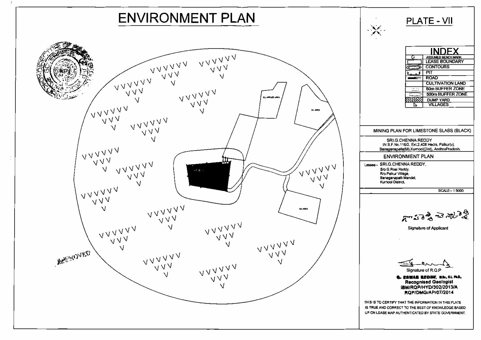
ENVIRONMENT PLAN
•
'
)
)
)
PLATE- VII
MINING PLAN FOR LIMESTONE SLABS (BLACK)
SRI.G.CHENNA REDDY IN S.F.No.116/2, Ext.2.408 Hects, Palkur(v),
AndhraPradesh.
ENVIRONMENT PLAN
Lessee:· SRI.G.CHENNA REDDY, S/o.G.Rosl Reddy, R/o.Palkur Village, Banaganapalll Mandai, Kurnool District
Signature of Applicant
Signature of R.Q.P
Q. ESWAa UDIIMI'. II.Sc.. B.l. Pti.D, Recognised Geologist
IBM/ROP/HYD/302/2013/A ~OP/DMG/AP/Oif201 -4
THIS IS TO CERTIFY THAT THE INFORMATION IN THIS PLATE
IS TRUE AND CORRECT TO THE BEST OF KNOWLEDGE BASED
UP ON LEASE MAP AUTHENTICATED BY STATE GOVERNMENT,