Embed Size (px)
Citation preview
www.rhydolabz.com
We bring the world to you..
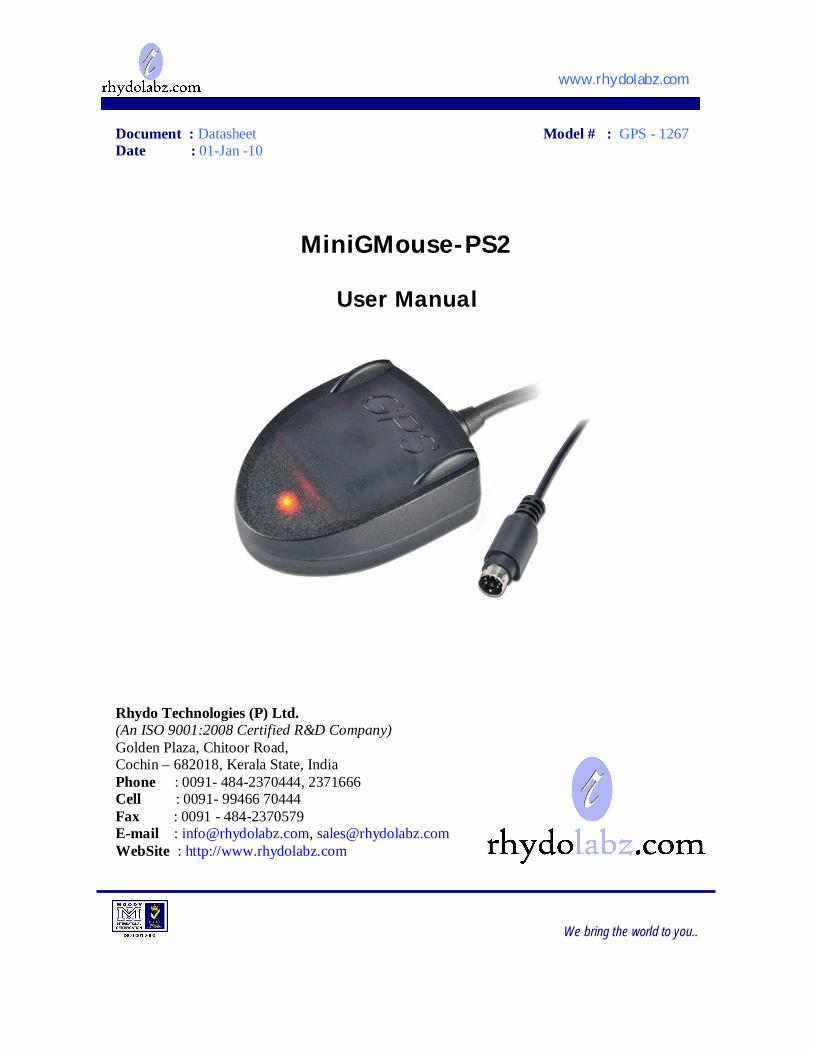
Document : Datasheet Model # : GPS - 1267 Date : 01-Jan -10
MiniGMouse-PS2
User Manual
Rhydo Technologies (P) Ltd. (An ISO 9001:2008 Certified R&D Company) Golden Plaza, Chitoor Road, Cochin – 682018, Kerala State, India Phone : 0091- 484-2370444, 2371666 Cell : 0091- 99466 70444 Fax : 0091 - 484-2370579 E-mail : [email protected], [email protected] WebSite : http://www.rhydolabz.com
www.rhydolabz.com
We bring the world to you..
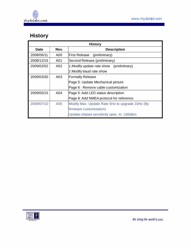
History
History Date Rev. Description
2008/06/11 A00 First Release (preliminary) 2008/12/16 A01 Second Release (preliminary) 2009/02/02 A02 1.Modify update rate show (preliminary)
2.Modify baud rate show 2009/03/30 A03 Formally Release
Page 5: Update Mechanical picture Page 6 : Remove cable customization
2009/05/15 A04 Page 5: Add LED status description Page 8: Add NMEA protocol for reference
2009/07/10 A05 Modify Max. Update Rate 5Hz to upgrade 10Hz (By firmware customization) Update chipset sensitivity spec. to -165dbm
www.rhydolabz.com
We bring the world to you..
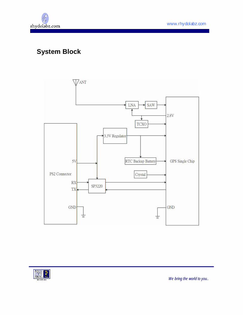
System Block
www.rhydolabz.com
We bring the world to you..
FEATURES
Description
The miniGMouse-PS2 is a GPS module. It is a GPS receiver providing a solution that high position and speed accuracy performances as well as high sensitivity and tracking capabilities in urban conditions .The GPS chipsets inside the module are designed by MediaTek Inc., which is the world's leading digital media solution provider and largest fab-less IC company in Taiwan. The module can support up to 66 channels. The GPS solution enables small form factor devices. They deliver major advancements in GPS performances, accuracy, integration, computing power and flexibility. They are designed to simplify the embedded system integration process. The module is the best choice for you to design the GPS related products.
L1 frequency, C/A code, 66-channel Embedded LNA and SAW filter
High sensitivity:Up to -165dBm tracking, superior urban performance1 Position accuracy:< 3m CEP (50%) without SA (horizontal)
Cold Start is Under 35 seconds (Typical) 1
Warm Start is Under 34 seconds (Typical) 1 Low power consumption:48mA@ acquisition, 38mA@ tracking DGPS(WAAS, EGNOS, MSAS) support (optional by firmware) Update rate:1Hz (Default)
RoHS compliant
1 Reference to GPS chipset specification
www.rhydolabz.com
We bring the world to you..
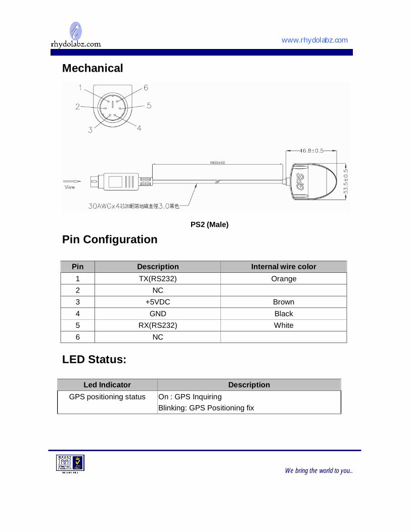
Pin Description Internal wire color 1 TX(RS232) Orange 2 NC
3 +5VDC Brown 4 GND Black 5 RX(RS232) White 6 NC
Mechanical
Pin Configuration
LED Status:
PS2 (Male)
Led Indicator Description GPS positioning status On : GPS Inquiring
Blinking: GPS Positioning fix
www.rhydolabz.com
We bring the world to you..
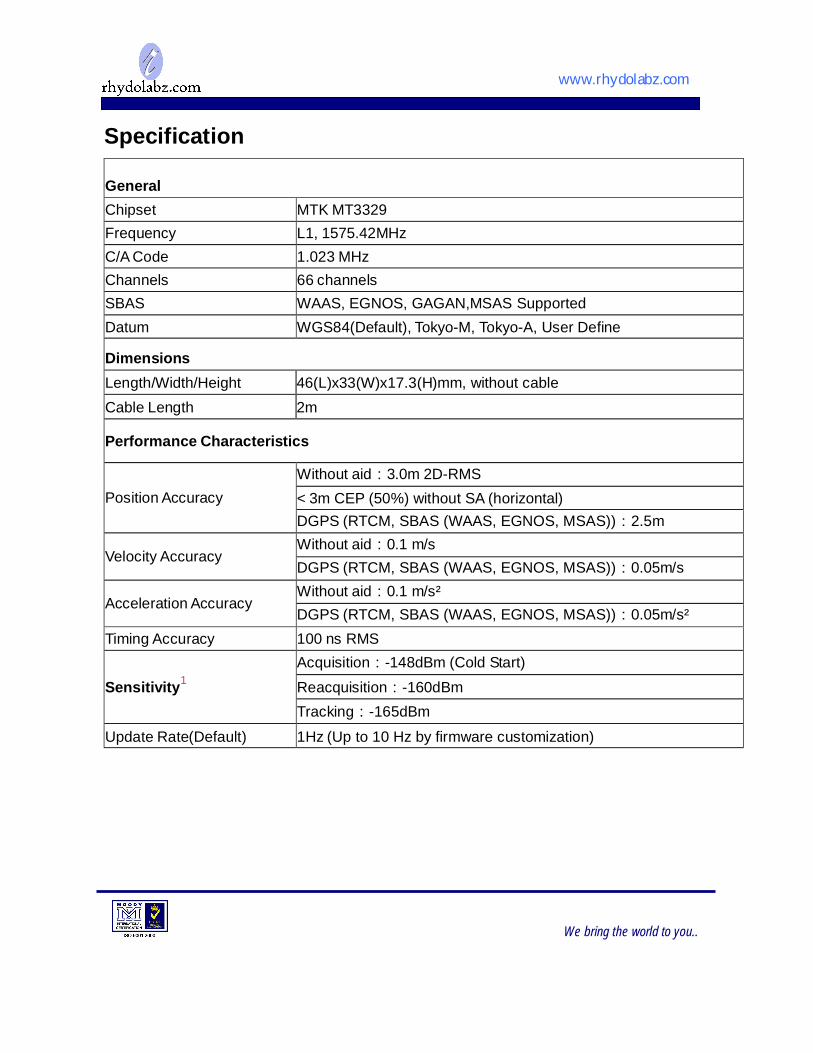
Specification
General Chipset MTK MT3329 Frequency L1, 1575.42MHz C/A Code 1.023 MHz Channels 66 channels SBAS WAAS, EGNOS, GAGAN,MSAS Supported Datum WGS84(Default), Tokyo-M, Tokyo-A, User Define Dimensions Length/Width/Height 46(L)x33(W)x17.3(H)mm, without cable Cable Length 2m Performance Characteristics
Position Accuracy
Without aid:3.0m 2D-RMS < 3m CEP (50%) without SA (horizontal) DGPS (RTCM, SBAS (WAAS, EGNOS, MSAS)):2.5m
Velocity Accuracy
Without aid:0.1 m/s DGPS (RTCM, SBAS (WAAS, EGNOS, MSAS)):0.05m/s
Acceleration Accuracy
Without aid:0.1 m/s² DGPS (RTCM, SBAS (WAAS, EGNOS, MSAS)):0.05m/s²
Timing Accuracy 100 ns RMS
Sensitivity1
Acquisition:-148dBm (Cold Start) Reacquisition:-160dBm Tracking:-165dBm
Update Rate(Default) 1Hz (Up to 10 Hz by firmware customization)
www.rhydolabz.com
We bring the world to you..
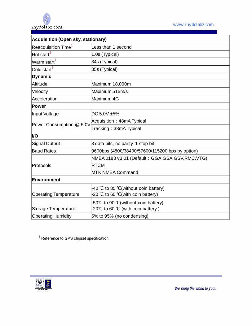
Acquisition (Open sky, stationary) Reacquisition Time1 Less than 1 second Hot start1 1.0s (Typical)
Warm start1 34s (Typical)
Cold start1 35s (Typical) Dynamic Altitude Maximum 18,000m Velocity Maximum 515m/s Acceleration Maximum 4G Power Input Voltage DC 5.0V ±5% Power Consumption @ 5.0V
Acquisition:48mA Typical Tracking:38mA Typical
I/O Signal Output 8 data bits, no parity, 1 stop bit Baud Rates 9600bps (4800/38400/57600/115200 bps by option) Protocols
NMEA 0183 v3.01 (Default:GGA,GSA,GSV,RMC,VTG) RTCM MTK NMEA Command
Environment Operating Temperature
-40 ℃ to 85 ℃(without coin battery) -20 ℃ to 60 ℃(with coin battery)
Storage Temperature
-50℃ to 90 ℃(without coin battery) -20℃ to 60 ℃ (with coin battery )
Operating Humidity 5% to 95% (no condensing)
1 Reference to GPS chipset specification
www.rhydolabz.com
We bring the world to you..
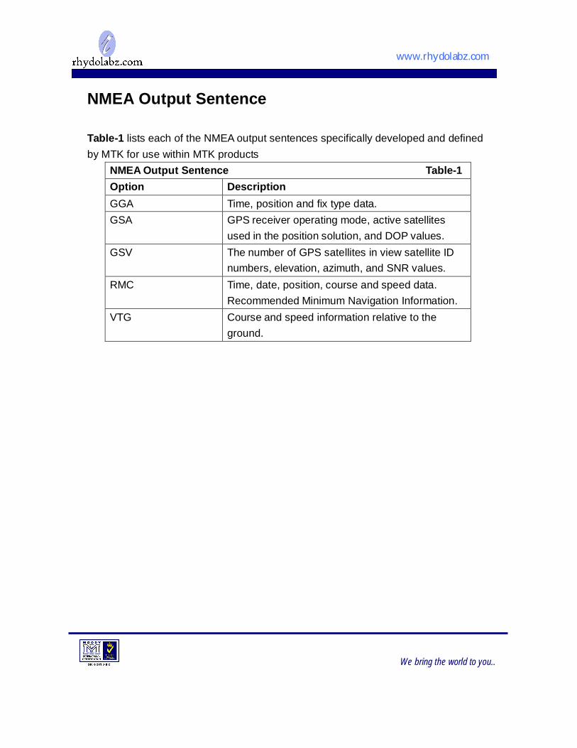
NMEA Output Sentence Table-1 lists each of the NMEA output sentences specifically developed and defined by MTK for use within MTK products
NMEA Output Sentence Table-1 Option Description GGA Time, position and fix type data. GSA GPS receiver operating mode, active satellites
used in the position solution, and DOP values. GSV The number of GPS satellites in view satellite ID
numbers, elevation, azimuth, and SNR values. RMC Time, date, position, course and speed data.
Recommended Minimum Navigation Information. VTG Course and speed information relative to the
ground.

www.rhydolabz.com
We bring the world to you..
GGA—Global Positioning System Fixed Data. Time, Position and fix related data for a GPS receiver Table-2 contains the values for the following example: $GPGGA,064951.000,2307.1256,N,12016.4438,E,1,8,0.95,39.9,M,17.8,M,,*65
GGA Data Format Table-2 Name Example Units Description Message ID $GPGGA GGA protocol header UTC Time 064951.000 hhmmss.sss Latitude 2307.1256 ddmm.mmmm N/S Indicator N N=north or S=south Longitude 12016.4438 dddmm.mmmm E/W Indicator E E=east or W=west Position Fix Indicator
1 See Table-3
Satellites Used 8 Range 0 to 14 HDOP 0.95 Horizontal Dilution of
Precision MSL Altitude 39.9 meters Antenna Altitude above/below
mean-sae-level Units M meters Units of antenna altitude Geoidal Separation
17.8 meters
Units M meters Units of geoidal separation Age of Diff. Corr. second Null fields when DGPS is not
used Checksum *65
<CR> <LF> End of message termination
Position Fix Indicator Table-3 Value Description 0 Fix not available 1 GPS fix 2 Differential GPS fix
www.rhydolabz.com
We bring the world to you..
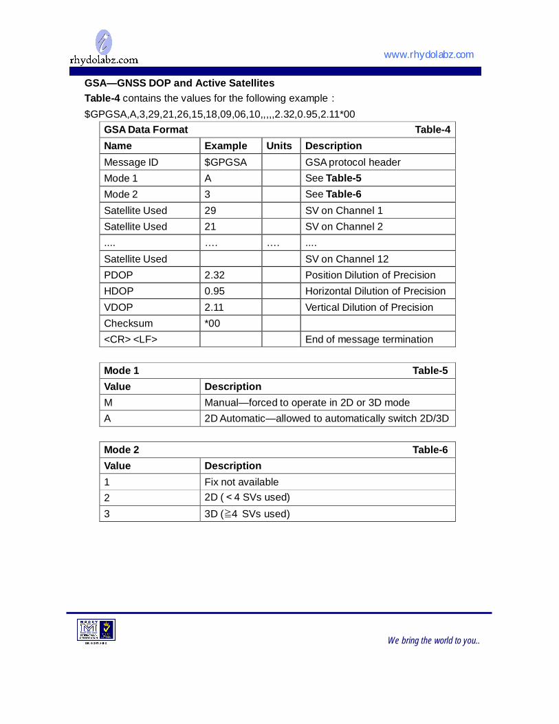
GSA—GNSS DOP and Active Satellites Table-4 contains the values for the following example: $GPGSA,A,3,29,21,26,15,18,09,06,10,,,,,2.32,0.95,2.11*00
GSA Data Format Table-4 Name Example Units Description Message ID $GPGSA GSA protocol header Mode 1 A See Table-5 Mode 2 3 See Table-6 Satellite Used 29 SV on Channel 1 Satellite Used 21 SV on Channel 2 .... …. …. .... Satellite Used SV on Channel 12 PDOP 2.32 Position Dilution of Precision HDOP 0.95 Horizontal Dilution of Precision VDOP 2.11 Vertical Dilution of Precision Checksum *00
<CR> <LF> End of message termination
Mode 1 Table-5 Value Description M Manual—forced to operate in 2D or 3D mode A 2D Automatic—allowed to automatically switch 2D/3D
Mode 2 Table-6 Value Description 1 Fix not available 2 2D (<4 SVs used) 3 3D (≧4 SVs used)
www.rhydolabz.com
We bring the world to you..
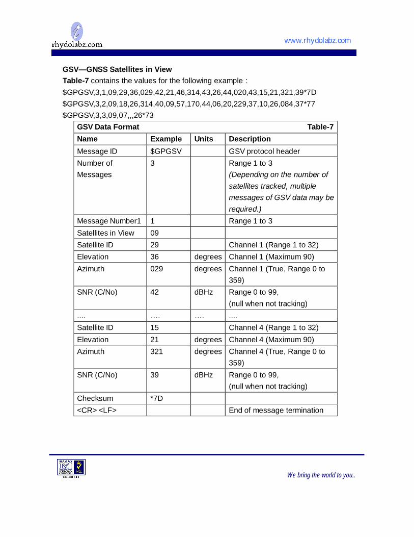
GSV—GNSS Satellites in View Table-7 contains the values for the following example: $GPGSV,3,1,09,29,36,029,42,21,46,314,43,26,44,020,43,15,21,321,39*7D $GPGSV,3,2,09,18,26,314,40,09,57,170,44,06,20,229,37,10,26,084,37*77 $GPGSV,3,3,09,07,,,26*73
GSV Data Format Table-7 Name Example Units Description Message ID $GPGSV GSV protocol header Number of Messages
3 Range 1 to 3 (Depending on the number of satellites tracked, multiple messages of GSV data may be required.)
Message Number1 1 Range 1 to 3 Satellites in View 09
Satellite ID 29 Channel 1 (Range 1 to 32) Elevation 36 degrees Channel 1 (Maximum 90) Azimuth 029 degrees Channel 1 (True, Range 0 to
359) SNR (C/No) 42 dBHz Range 0 to 99,
(null when not tracking) .... …. …. .... Satellite ID 15 Channel 4 (Range 1 to 32) Elevation 21 degrees Channel 4 (Maximum 90) Azimuth 321 degrees Channel 4 (True, Range 0 to
359) SNR (C/No) 39 dBHz Range 0 to 99,
(null when not tracking) Checksum *7D
<CR> <LF> End of message termination
www.rhydolabz.com
We bring the world to you..
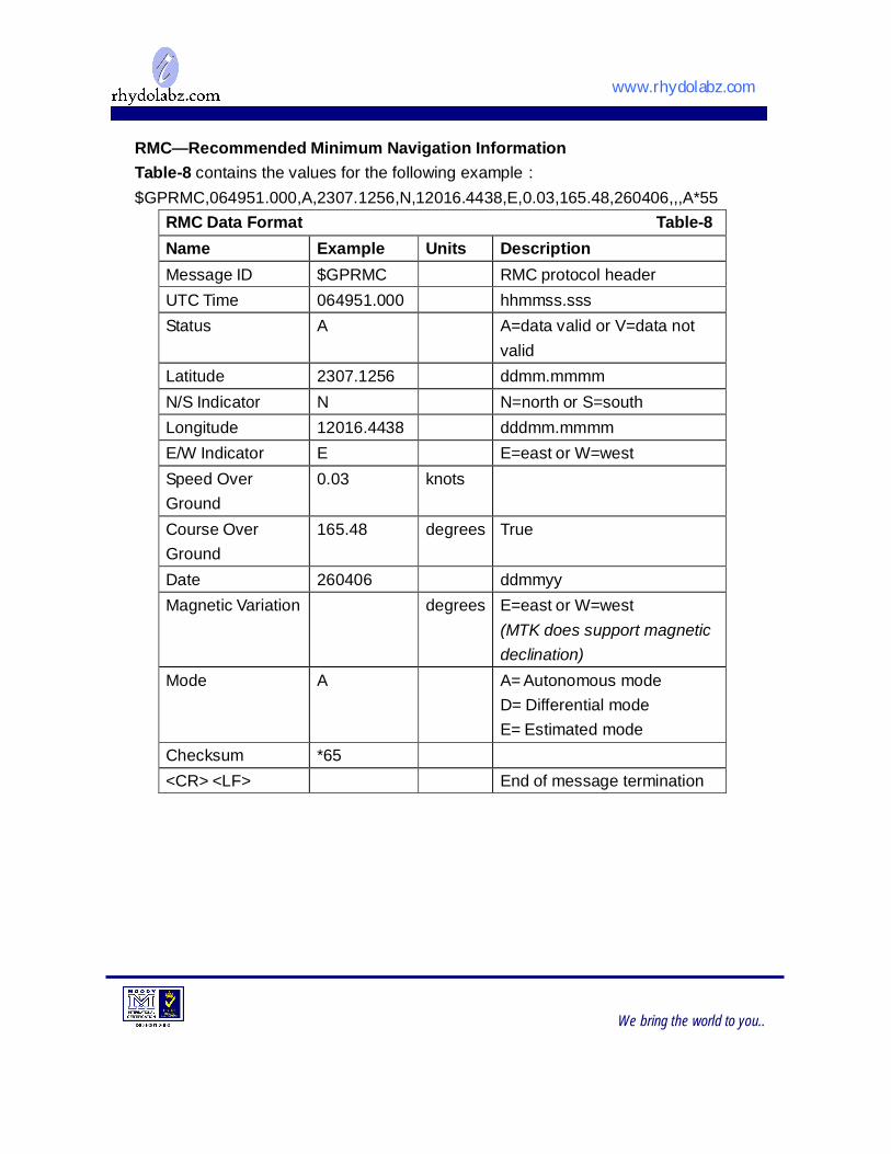
RMC—Recommended Minimum Navigation Information Table-8 contains the values for the following example: $GPRMC,064951.000,A,2307.1256,N,12016.4438,E,0.03,165.48,260406,,,A*55
RMC Data Format Table-8 Name Example Units Description Message ID $GPRMC RMC protocol header UTC Time 064951.000 hhmmss.sss Status A A=data valid or V=data not
valid Latitude 2307.1256 ddmm.mmmm N/S Indicator N N=north or S=south Longitude 12016.4438 dddmm.mmmm E/W Indicator E E=east or W=west Speed Over Ground
0.03 knots
Course Over Ground
165.48 degrees True
Date 260406 ddmmyy Magnetic Variation degrees E=east or W=west
(MTK does support magnetic declination)
Mode A A= Autonomous mode D= Differential mode E= Estimated mode
Checksum *65
<CR> <LF> End of message termination
www.rhydolabz.com
We bring the world to you..
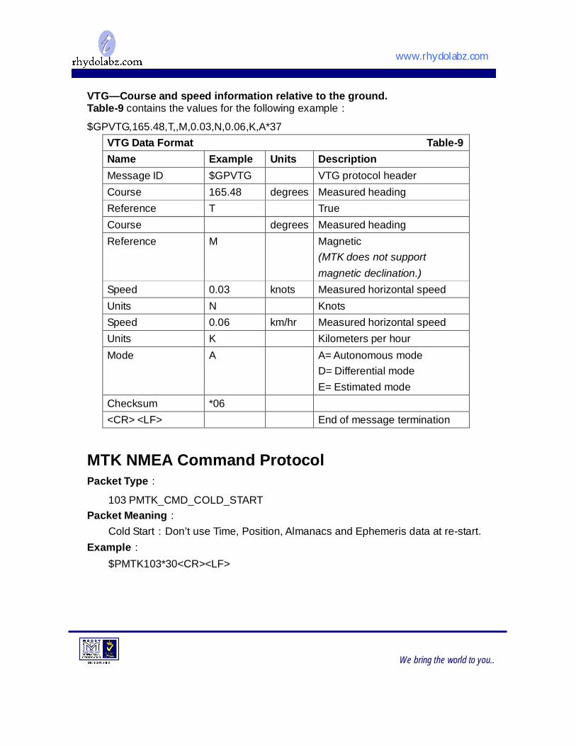
VTG—Course and speed information relative to the ground. Table-9 contains the values for the following example: $GPVTG,165.48,T,,M,0.03,N,0.06,K,A*37
VTG Data Format Table-9 Name Example Units Description Message ID $GPVTG VTG protocol header Course 165.48 degrees Measured heading Reference T True Course degrees Measured heading Reference M Magnetic
(MTK does not support magnetic declination.)
Speed 0.03 knots Measured horizontal speed Units N Knots Speed 0.06 km/hr Measured horizontal speed Units K Kilometers per hour Mode A A= Autonomous mode
D= Differential mode E= Estimated mode
Checksum *06
<CR> <LF> End of message termination MTK NMEA Command Protocol Packet Type:
103 PMTK_CMD_COLD_START Packet Meaning:
Cold Start:Don’t use Time, Position, Almanacs and Ephemeris data at re-start. Example:
$PMTK103*30<CR><LF>
www.rhydolabz.com
We bring the world to you..
TECHNICAL SUPPORT
If you are experiencing a problem that is not described in this manual, please contact
us. Our phone lines are open from 9:00 AM – 5.00 PM (Indian Standard Time) Monday through Saturday excluding holidays. Email can be sent to [email protected]
LIMITATIONS AND WARRANTEES
This product is intended for personal or lab experimental purpose and in no case should be used where it harmfully effect human and nature. No liability will be accepted by the publisher for any consequence of its use. Use of the product software and or hardware is with the understanding that any outcome whatsoever is at the users own risk. All products are tested for their best performance before shipping, still rhydoLABZ is offering One year Free service warranty (Components cost + Shipping cost will be charged from Customer ).
DISCLAIMER
Copyright © Rhydo Technologies (P) Ltd
All rights are reserved. Reproduction in whole or in part is prohibited without the prior written consent of the copyright owner. The information presented in this document does not form part of any quotation or contract, is believed to be accurate and reliable and may be changed without notice.
Rhydo Technologies (P) Ltd. (An ISO 9001:2008 Certified R&D Company) Golden Plaza, Chitoor Road, Cochin – 682018, Kerala State, India Phone : 0091- 484-2370444, 2371666 Cell : 0091- 99466 70444 Fax : 0091 - 484-2370579 E-mail : [email protected], [email protected] WebSite : http://www.rhydolabz.com