Embed Size (px)
Citation preview

Mineral Resources of theVentana Primitive AreaMonterey County, CaliforniaBy ROBERT C. PEARSON and PHILIP T. HAYES, U.S. GEOLOGICAL SURVEY, and PAUL V. FILLO, U.S. BUREAU OF MINES
STUDIES RELATED TO WILDERNESS PRIMITIVE AREAS
GEOLOGICAL SURVEY BULLETIN 1261-B
An evaluation of the mineral potential of the area
UNITED STATES GOVERNMENT PRINTING OFFICE. WASHINGTON : 1967
UNITED STATES DEPARTMENT OF THE INTERIOR
STEWART L. UDALL, Secretary
GEOLOGICAL SURVEY
William T. Pecora, Director
For sale by the Superintendent of Documents, U.S. Government Printing Office Washington, D.C. 20402

STUDIES/ RELATED TO WILDERNESS
PRIMITIVE AREAS
Pursuant to the Wilderness Act (Public Law 88-577, Sept. 3, 1964) and the Conference Report on Senate 'bill 4, 88th Congress, the U.S. Geological Survey and the U.S. Bureau of Mines are making mineral surveys of wilderness and primitive areas. Areas officially designated as "wilder ness," "wild," or "canoe" when the act was passed were incorporated into the National Wilderness Preservation System. Areas classed as "primitive" were not included in the Wilderness System, but the act provided that each primitive area should be studied for its suitability for in corporation .into the Wilderness System. The' mineral surveys constitute one aspect of the suitability studies. This bulletin reports the results of a mineral survey in the Ventana primitive area, California. The area discussed in the report corresponds to the area under consideration for wilderness status. It is not identical with the Ventana Primitive Area as defined because modifications of the boundary have been proposed for the area to be considered for wilderness status. The area that was studied is referred to in this report as the Ventana primitive area.
This bulletin is one of a series of similar reports on primitive areas.


CONTENTS
Page
Summary. ________________________________^_ ______________________ BlGeology and mineral resources, by Robert C. Pearson and Philip T.
Hayes________________________________________________________ 2Introduction._________________________________________________ 2
Location and geography.___________________________________ 2Previous work____________________________________________ 5Present work and acknowledgments_^________________________ 5
Geology._____________________________________________________ 6Geologic setting.__________________________________________ 6Rocks of the Sur Series of Trask.___________________________ 7Intrusive rocks.___________________________________________ 8Sedimentary rocks.________________________________________ 10Structure. __--__---_---_-_---_-_-_-_--_-_-_____-__________ 11
Mineral Resources.____________________________________________ 13Setting___________________--_._______________ 13Methods of evaluation.____________________________________ 15Evaluation of metallic minerals____________________________ 36Limestone (marble)-_----------------_-_-__--___-____-_____ 39Oil and gas__-_-_-_________---------__-_-____-_-_______-__ 40
Economic appraisal, by Paul V. Fillo_______________________________ 41Introduction. _________________________________________________ 41Mining claims_______________________________________________ 41Conclusions.__________________________________________________ 41
References cited___________________________________________________ 42
ILLUSTRATIONS
Page
PLATE 1. Geologic map of the Ventana primitive area, California. _ In pocket 2. Map of the Ventana primitive area showing sample localities
and geologic traverses.__________________________ In pocket
FIGURE 1. Index map showing location of Ventana primitive area. _ _ _ _ B3 2-5. Photograph of
2. Northwest-trending ridges of Santa Lucia Range. _ _ _ 43. Ventana Double Cone._________________________ 44. Ridge west of Ventana Double Cone____________ 95. Logwood Ridge___--__-__-----_-_-------------_ 12

VI CONTENTS
TABLES
Page TABLE 1. Analyses of samples from the Ventana primitive area, Mont-
erey County, Calif_________________.___.____________ B162. Partial analyses of marble samples..__._--___.__________ 40
STUDIES RELATED TO WILDERNESS PRIMITIVE AREAS
MINERAL RESOURCES OF THE VENTANA PRIMITIVE AREA, MONTEREY COUNTY, CALIFORNIA
By EGBERT C. EEARSON and PHILIP T. HAYES, U.S. Geological Survey, and PAUL V. FILLO, U.S. Bureau of Mines
SUMMARY
A minerals survey of the Ventana primitive area was made by the U.S. Geolog ical Survey during the summer of 1986, and the area was visited again briefly in January 1967 by Geological Survey and U.S. Bureau of Mines personnel. The area includes about 185 square miles in a rugged part of the California Coast Range southeast of Monterey. It is formed largely of metamorphic rocks of probable Paleozoic age which have been intruded by a wide variety of plutonic rocks of Jurassic to Cretaceous age. The crystalline rocks are locally overlain by sedimentary rocks ranging in age from Late Cretaceous to early Miocene. All the rocks have been broken by faults many of which have a northwest trend.
Geologic examination along several hundred miles of foot traverse and semi- quantitative spectrographic and chemical analyses of more than 500 samples of stream sediments and bedrock did not indicate any mineral deposits of eco nomic significance. Stream-sediment samples were collected from many points along all the major drainage courses and from most of their tributaries. Samples also were taken of all the major and most of the minor varieties of bedrock in the area and included much altered rock from fault zones and elsewhere. A few of the samples contained traces of copper, lead, zinc, and molybdenum in amounts that seemed to be anomalously high, although below ore grade. Some of these localities were revisited and sampled extensively in January 1967. Most of the relatively high values are from samples of weathered sulfide-bearing gneiss or of stream sediments derived from areas where such rock is abundant. These rocks are not considered to be of economic value.
No mineral deposits were known previously in the Ventana primitive area and none were discovered during this investigation. In the surrounding region, large mercury deposits and less important deposits of chromite, manganese, and asbestos are known, but they all occur in a rock formation that is not in the primitive area. Similarly, oil, gas, and diatomite produced in nearby areas are in rocks younger than any in the primitive area. Rocks similar to some in the primitive area contain small copper deposits in nearby localities, but only traces of copper were found within the primitive area. Lenses of marble having a composition suitable for a source of lime are present in small bodies, mostly in rugged terrane remote from transportation. Larger and much more accessible
Bl

B2 STUDIES RELATED TO WILDERNESS' PRIMITIVE AREAS
bodies of marble are available immediately west of the area, but these have not been commercially exploited to date.
GEOLOGY AND MINERAL RESOURCES
By ROBERT C. PEABSON and PHILIP T. HAYES U.S. Geological Survey
INTRODUCTION
LOCATION AND GEOGRAPHY
The Ventana primitive area in Los Padres National Forest includes about 185 square miles of the Northern Santa Lucia Range, Monterey County, Calif, (fig. 1). The area is about 27 miles long and 4 to 9 miles wide.
The Ventana primitive area is an anachronism in mid-20th-century California. It is only a few hours drive from two major metropolitan areas, and it is almost within sight of two of the most heavily traveled highways in the State. The scenic coast highway (California Highway 1) parallels the primitive area at a distance of 2 to 5 miles, and U.S. Highway 101 lies in the Salinas River valley to the northeast. Thou sands of people drive within 15 miles of the area each day, but despite its proximity to civilization, only a few hundred people penetrate more than a mile into it each year.
The primitive area through much of its length is only 2 to 5 miles from the coast its southwest boundary coincides with the crest of the coast ridge 3,000 to 4,000 feet above the ocean. The northwest-trending Santa Lucia Range rises abruptly from the rugged and scenic Pacific coast and is flanked 25 miles to the northeast by the broad flat Salinas River valley. The range ends on the northwest at Monterey Bay, about 10 miles from the primitive area.
The area is drained by four major streams: the Big Sur and Little Sur Rivers to the southwest; the Carmel River to the northwest; and the Arroyo Seco, a tributary to the Salinas River, to the northeast. The topography of the area is influenced by the northwest-trending geo logic structure, and many of the streams follow valleys thus oriented (fig. 2).
The southeastern part of the area is accessible by way of the Arroyo Seco Road from the Salinas River valley to Arroyo Seco Guard Sta tion. From this point the Indians Road, a graded public road, parallelspart of the southeast boundary of the area, at a distance of about 1
mile. A U.S. Forest Service limited-access road from Posts on Cali fornia Highway 1 coincides with the primitive area boundary about 8 miles along its southwestern edge. The private roads to Tassajara Hot Springs and to The Caves approach to within 1 mile of the eastern part of the primitive area. A public road to Bottchers Gap comes to

THE VENTANA PRIMITIVE AREA, MONTEREY COUNTY, CALIF.
122° 121°
B3
37°
l^l^KL-VENTANA PRIMITIVE::: :£ l^$:fr::'!-:--."jA . _ _ .
10 20 MILES_J
FIGURE 1. Index map showing location of Ventana primitive area.
within 1 mile of the northwestern part. Several other private roads approach the periphery of the northern third of the area. Travel with in the area is by foot or horseback on a very good network of U.S. Forest Service trails.
Topographically the area is characterized by steep-sided sharp- crested ridges separated by V-shaped youthful valleys. Over much of their length the streams flow on bedrock or a veneer of boulders; alluvial deposits along their courses are small or absent. Many of the
264-034 O "67 2

B4 STUDIES RELATED TO WILDERNESS PRIMITIVE AREAS
streams occupy narrow canyons with vertical walls; waterfalls are common, and deep pools occupy the valley floor from wall to wall in places. Elevations range from about 600 feet where the Big Sur River leaves the area to 4,965 feet on South Ventana Cone.
Virtually the entire area is covered by timber or brush (fig. 3). Along the Big Sur and Little Sur Rivers beautiful stands of redwood occur as far as 6 miles from the coast and at elevations up to about 2,000 feet. Some of the slopes and ridgetops are fairly open live oak and madrona forest and here and there are virgin stands of
FIGURE 2. View up the North and South Forks of the Uig Sur River from Ventana Double Cone showing the northwest-trending ridges that form this part of the Santa Lucia Range. Beyond limits of primitive area is Junipero Serra Peak, highest in the range, in distance at left. 'Southwest boundary of primitive area lies along skyline ridge at right.
FIOTJKE 3. Aerial view of Ventana Double Cone from southeast. Brush-covered slopes like this are typical of much of the primitive area.

THE VENTANA PRIMITIVE AREA, MONTEREY COUNTY, CALIF. B5
ponderosa pine. Most of the area, however, is mantled by dense chaparral. The climate is mild throughout the area, but precipitation, which falls mainly from December to April, ranges widely from more than 100 inches a year along the coast ridge to only about 20 inches a few miles farther inland. At Cold Spring Camp, only a few hundred feet outside the primitive area near the head of Logwood Creek, precipitation of 161 inches recorded in the 12-month period from July 1940 to June 1941 is the greatest recorded in California (Waananen and Bean, 1966, p. 457). Snow occasionally falls on the higher peaks. Coastal fog and cool sea breezes frequently penetrate up the major valleys but rarely top the ridges, so most of the area is hot and dry in summer.
PREVIOUS WORK
The geology of the Ventana primitive area was fairly well known prior to the present investigation. Reports by Trask (1926), Reiche (1937), and Fiedler (1944) describe the rocks and structure and include geologic maps at a scale of about 1 mile per inch that cover all of the primitive area except about 1 square mile of the southeastern- most tip. The geology of that square mile has been studied by Comp- ton (1966) and his coworkers as part of the geologic mapping of the Junipero Serra quadrangle. Earlier reconnaissance studies of the region and detailed studies in nearby areas were cited by these work ers. Investigations dealing with stratigraphy of the Tertiary rocks and petrology of some of the crystalline rocks have been described by Dickinson (1965) and Compton (1960a). The geology of the northern part of the primitive area has recently been mapped in detail by Robert A. Wiebe as part of a Ph.D. dissertation at Stanford University. This report has not yet been published and was not avail able to the writers; however, Mr. Wiebe was very helpful in discussing the geology of this area with us.
PRESENT WORK AND ACKNOWLEDGMENTS
The writers, with the assistance of Robert W. Sullivan, spent about 2 months in the primitive area from July to September 1966 and examined the rocks for evidence of mineralization, checked existing geologic maps, and systematically sampled rocks and stream sedi ments. The fieldwork was performed by foot traverse along the exist ing trails, most stream courses, tractor trails along many ridgetops, and, in places, cross country. Some traverses were made into the area from various points on the periphery, others from camps within the area, and still others by means of helicopter. The area was revisited for a week in January 1967 to reinvestigate certain parts as a result of analytical tests on previously taken samples.

B6
Analytical tests for mercury were made on most of the samples in a mobile field laboratory by Robert Hanson and Roger Miller, U.S. Geological Survey. The other analyses were made in Geological Sur vey laboratories in Denver, Colo., and in Washington, D.C.
Fieldwork in the primitive area was greatly facilitated by Mr. Alex Campbell, District Ranger, U.S. Forest Service, and members of his staff, particularly Mr. Doug McChesney, whose detailed knowledge of the area was invaluable, and Emil Pozzi, William Clark, and M. H. Netland, who provided horse-packing services and other assist ance. A helicopter under contract to the Forest Service and based at the Arroyo Seco Guard Station was used for field transport and we are indebted to Mr. Fred Dearing, its capable pilot. Mr. Frisby at Pico Blanco Boy Scout Camp and numerous property owners kindly per mitted access to the area over private roads and trails.
GEOLOGY
The northern Santa Lucia Range is part of a northwest-trending block of crystalline rocks about 40 miles wide and more than 300 miles long. The crystalline block is bounded on the northeast by the San Andreas fault, some 30 miles northeast of the primitive area, and on the southwest by the Sur-Nacimiento fault, which skirts the coast and passes out to sea west of the area. Sedimentary and associ ated igneous rocks of the Franciscan Formation of Jurassic and Cretaceous age have been faulted against the crystalline block on both the northeast and southwest sides. These Franciscan rocks are not present within the block. Throughout its length, the crystalline block is discontinuously covered by a blanket of unmetamorphosed sedi mentary rocks of Late Cretaceous and .Tertiary age.
The primitive area lies within one of the largest areas of exposure of the pre-Upper Cretaceous or crystalline rocks. In this vicinity (pi. 1) these rocks consist of an older group of metamorphosed sedimentary and possibly volcanic rocks and a younger group of plutonic igneous rocks that intruded the metamorphic rocks.
Unmetamorphosed sedimentary rocks cover the crystalline rocks of large areas in the general region but are present in only about 10 percent of the primitive area, mainly in the southern part. These strata were deposited on the crystalline rocks after uplift and much erosion. Those immediately overlying the older rocks differ in age from place to place. Thus, during much of the last hundred million years the area of the northern Santa Lucia Range has been alternatelyabove and below sea level, at times being eroded and at times receiv ing sediment. During the last 10 million years the range was uplifted

THE VENTANA PRIMITIVE AREA, MONTEREY COUNTY, CALIF. B7
to approximately its present height of up to 5,000 feet. This uplift took placa by arching and by movement along many faults. During and sinca this uplift the sedimentary rocks have been eroded from much of the area, and they are now preserved only as down-faulted blocks *nd thin fault slices.
ROCKS OP 'I'M M STJR SERIES OF TRASK
Tie oldest rocks in the primitive area are a diverse group of meta- morphic rocks called the Sur Series by Trask (1926). They form the bedrock in more than half the area. These rocks tend to be deeply weathered and poorly exposed except along perennial streams where erosion has kept pace with weathering.
The metamorphic terrane consists of a series of sedimentary and possibly volcanic rocks that have been metamorphosed to gneisses and schists of various types. The most abundant are quartz-rich gneisses that contain variable amounts of feldspar and biotite. Throughout the area these are interlayered with biotite schist, amphibolite, marble, and calc-silicate gneiss. To some extent all the gneisses and schists are gradational with one another. Nearly all the metamorphic rocks have a conspicuous foliation. The strong layering in the better exposures is indicative of the original sedimentary bedding.
The quartzose gneisses range from quartzite to biotite-quartz gneiss, quartz-feldspar gneiss, and biotite-quartz-feldspar gneiss. Locally, they also contain garnet, sillimanite, hornblende, graphite, or sulfide minerals. Light-colored quartzose gneisses, particularly quartz-feldspar gneiss, are characteristic of the southwestern part of the primitive area; in the central and northeastern parts of the area the gneisses are generally a darker gray because of a greater biotite content. Some of the quartz-feldspar.gneisses may have been derived from igneous rocks as suggested by Reiche (1937, p 119). Quartzite containing very small amounts of other minerals forms lenticles and layers as much as a few inches thick in most of the quartz-feldspar gneiss, but in the biotitic gneisses it forms discrete beds several feet thick and locally is the principal component of sequences up to several hundred feed thick, as in upper Redwood Creek, North Fork Big Sur River, and along the Arroyo Seco.
Mica-rich schist occurs widely in thin discontinuous layers in the gneisses and in places forms units 100 feet or more thick, as along the North Fork of Big Sur River south of Cienega Creek. The schist commonly contains sillimanite and garnet.
Dark green to black, foliated to massive amphibolite is also wide spread as generally concordant layers from a few inches to many

B8 STUDIES RELATED TO WILDERNESS PRIMITIVE A.REAS
tens of feet thick. It consists of hornblende and plagioclaso and sub ordinate biotite and pyroxene. Amphibolite is the dominant meta- morphic rock of large areas along Zigzag Creek.
Marble and calc-silicate gneiss form pods and discontinuous layers throughout the metamorphic sequence but are most abundant along the southwestern edge of the primitive area. The largest bodies of relatively pure marble are shown separately on plate 1. The marble is more resistant to weathering than any other rock in the area, and con sequently it generally forms prominent outcrops and is recognizable from a distance even where the brush is thick. Bodies of marble irange from about 1 foot thick and a few feet long to about 100 feet thick and more than 1,000 feet long. The marble is generally white and filnely to coarsely crystalline; most of it contains some crystalline grap.hite. The marble is generally associated with calc-silicate gneiss, and the two grade into one another. The most conspicuous minerals of the c ale- silicate gneiss include wollastonite, diopside, garnet, scapolite, and amphibole. Layered sequences of calc-silicate gneiss tend to be thicker and more continuous than the associated marble; in Eedwood Cre--ek and North Fork Big Sur Kiver they attain a thickness of several hundred feet.
Rocks of the Sur Series of Trask (1926) originally were sandy, muddy, and limy sediments that probably were many thousand feet in thickness. They probably included some interbedded basaltic lava flows. The age Of these sediments is not known but is generally thought to be Paleozoic or even Precambrian. The sediments were folded, meta morphosed to gneisses and schists, and intruded by igneous rocks in middle to late Mesozoic time.
INTRUSIVE ROCKS
Plutons with a wide range of composition have intruded the meta morphic rocks throughout the primitive area. The bodies range from irregular veinlets less than 1 inch in thickness to stocks many square miles in area. Only the larger bodies are shown on plate 1. The larger
. bodies are more resistant to erosion than the surrounding gneisses andschists, hence they tend to form, the highest peaks and ridges. No ex tensive hypogene alteration associated with the igneous rocks wasnoted.,
Nearly every outcrop of metamorphic rocks is cut by small bodies of light-colored intrusive rock that includes granite pegmatite, alaskite, and luecotonalite and consists mainly of quartz and feldspars and commonly some biotite and garnet. The larger plutons are mostly quartz diorite and granodiorite although quartz monzonite, granite,diorite, and gabbro are also present. The largest area of plutonic rock

THE VENTANA PRIMITIVE AREA, MONTE RE Y COUNTY, CALIF. B9
extends from the vicinity of Ventana Cone northwestward to beyond the primitive area boundary. It is mainly gray gneissic even-grained biotite-hornblende quartz diorite to granodiorite. Although the rock is fairly homogeneous over large areas, parts of it, especially near its borders, are more potassic. More than one pluton may be present. An elliptical pluton between Skinner and Pine Creeks (Little Sur Kiver tributary) is a distinctive porphyritic quartz monzonite with pink potassium feldspar phenocrysts and occasional garnet. Similar rock is also present along the Carmel River near the mouth of Miller Fork and in Pine Creek (Carmel River tributary).
The plutons in the southeastern half of the primitive area are smaller and more nonhomogeneous than those to the northwest. They are peg- matoid in part, contain less hornblende and more potassium feldspar, and include abundant septa of metamorphic rocks. As these features are characteristic of the border zones of the quartz diorite and gran odiorite plutons farther northwest (fig. 4), those in the southeast may be the roof parts of plutons not yet eroded as deeply.
Gabbro and diorite form a nonhomogeneous pluton exposed along the Carmel River southwest of Pine Valley. The rocks are fine to medium grained, dark gray to black, and foliated to massive. A fine grained dark gray weakly foliated rock specimen examined micro scopically consists of hornblende and labradorite. Smaller bodies of
FIGTJKE 4. View west from Ventana Double Cone toward rugged ridge of granitic rocks and septa of metamorphic rocks. Post Summit on primitive area boundary is in distance at left. Pico Blanco, in distance at right, is beyond limits of prim itive area. ' " .
'.' '-' - '--' 5 ". - '-''- -? '
BIO
similar mafic rocks are also common along the Carmel River for a few miles farther downstream.
SEIMMKNTARY ROCKS
Sedimentary rocks of Late Cretaceous and Tertiary age lie on the older crystalline rocks in the southern part of the primitive area and are locally preserved in down-dropped wedges along faults in the northern part. Locally, as in the Church Creek area (DickinsOn, 1965), these rocks have been studied in some detail, the sequence subdivided, and several stratigraphic names assigned. Such local stratigraphic studies and the identification of diagnostic fossils have established the age and conditions of deposition in some places. The picture is incom plete, however, and in this report only a general description of the rocks and their depositional history is given.
The oldest and most widespread of the sedimentary rocks is a sequence of interbedded conglomerate, sandstone, siltstone, and clay- stqne in the southern part of the area. These rocks were studied by Reiiche (1937) and fossils collected by him indicate a Late Cretaceous age;. Reiche estimated the maximum thickness of the sequence to be 6,000 feet. Nearly everywhere in the primitive area the Upper Cre taceous rocks are strongly faulted and only at a few places are deposi- tiorial contacts with the older rocks exposed at the surface. Commonly the basal beds are pebble and cobble conglomerates that have an indiurated sandy matrix. Similar beds and lenses recur at numerous places throughout the section. Bedding in the conglomerate is gener ally well defined. The pebbles and cobbles are w^ell rounded and are mainly composed of granitic rocks, porphyry, quarteite, chert, and metamorphic rocks. The granitic and metamorphic rocks could have beeni locally derived, and the chert may have come from the .Fran ciscan Formation. The most conspicuous of the sedimentary rocks are resistant massively bedded medium- to coarse-grained feldspathic sand'stone, which weathers buff to light brown. Finer grained and more poorlly sorted sandstone is also common. Many of the sandstones are pebblly. Probably the most abundant rocks in the sedimentary sequence are sa;Jidy siltstone, isiltstone, mudstone, and claystone, that vary from mediuim to dark gray to greenish gray. These rocks are relatively non- resista.nt and not well exposed. Many of the siltstones and clay stones contain abundant n'odular concretions, some of which have formed around fossil plant fragments.
Strata of Paleocene, Eocene, and Oligocene age have been identified in the southeastern part of the primitive area (Compton, 1957), on the rid^e north of Higs^ins Creek (Reiche, 1937, p. 144), and along Tassajara and Church Creeks (Dickinson, 1965). Lithologically, these

THE VENTANA PRMITIVE AREA, MONTEREY COUNTY, CALIF. Bll
strata are very similar to those of Late Cretaceous age described in the preceding paragraph, and they have been distinguished chiefly on the basis of their fossil content. The Paleocene rocks lie with apparent conformity on Upper Cretaceous rocks except along the Willow Creek fault, where they lie dir ectly on the crystalline rocks. Along the Church Creek fault sedimentary rocks of middle to late Eocene age rest directly on the crystallines. Strata of Oligocene age overlie the Eocene rocks in the Church Creek area., and very locally in the extreme southeastern part of the area lower Miocene sedimentary rocks unconformably overlie older Tertiary stirata.
Some of the thin wedges of sedimentary rocks along faults in the northern part of the area, have not been definitely correlated with other rocks in the vicinity and their age is uncertain.
STRTJCTUHE
The structure of the me'tamorphic rocks is poorly known, but on the basis of scattered observation the rocks probably are folded strongly rather than being a faulted homoclinal sequence as suggested by Trask (1926, p. 127) and Reiche (1937, p. 156). Fiedler (1944, p. 184- 185) considered the likelihood that the metamorphic rocks are folded. Although the dominant strike is northwesterly and the dip north easterly, abrupt changes in attitude are common in some areas. Minor folds and well-developed mineral lineation also suggest that the sequence is strongly folded.
The sedimentary rocks in the primitive area have been moderately deformed by faulting. No folds of more than local importance have been recognized, and Eeiche (1937, p. 156-157) suggests that the synclinal nature of some fault blocks is caused by drag along the faults. The sedimentary rocks ,have been strongly folded where they are more extensively exposed in areas bordering the primitive area. In the Junipero Serra quadrangle southeast of the primitive area, Compton (1960b, 1966) concluded that t|ie crystalline core of the Santa Lucia Range was folded along \\vith the overlying sedimentary rocks and that these folds were then cult by high-angle faulty during Plio cene and Pleistocene uplift of the rang;e. It seems likely, therefore, that the homoclinal fault blocks within the primitive larea are the faulted remnants of folds. j \
The principal faults recognized within the primitive area trend northwest, parallel to the major structural elements of \the region. They all seem to dip steeply, but the only one for which\the dip is established is the Church Creek reverse fault (pi. 1), which was determined by Dickinson (1965) to dip 50°-80° NE. The much faulted area of sedimentary rocks in the southern part of the area
264-034 O 67 3

B12 STUDIES RELATED TO WILDERNESS PRIMITIVE AREAS
is basically a northwest-trending graben complicated by minor faults striking in diverse directions. One of these is the east-northeast-trend ing Willow Creek fault which, according to Dickinson (1965), under went movement at least twice during the Tertiary.
The relative fault movement appears to be vertical. However, in this region of large scale strike-slip faulting, lateral movement on some of the faults in the primitive area is a possibility. The San Andreas fault to the northeast and the Sur-N"acimiento fault (Hill and Dibblee, 1953) 1 to 2 miles southwest of the primitive area prob ably have large lateral displacement, and Durham (1965) has pre sented evidence for 11 miles of strike-slip movement on a fault trending toward the primitive area from the southeast.
Most of the faults mapped in the primitive area have been recog nized because they cut sedimentary rocks (fig. 5); many others prob ably exist in the metamorphic rocks. Fiedler (1944, p. 185) traced a few faults through the metamorphic rocks, "but only with the expendi ture of much time and effort, and only where the faults had first been recognized in some sedimentary area."
The few faults that have been observed vary widely in the amount of deformation along them. The Church Creek and Miller Creek faults northeast of the primitive area are described by Dickinson (1965,
FIGUEE 5. Logwood Ridge viewed from northeast across junction of North and South Forks of Big Sur River. Left half of ridge top consists of Upper Creta ceous conglomerate in fault contact with Sur Series of Trask (1926) on right.

THE VENTANA PRIMITIVE AREA, MONTEREY COUNTY, CALIF. B13
p. 40) as gouge zones that are less than a foot thick and have some shearing and gouge seams extending from 5 to 100 feet into the walls. Fiedler (1944, p. 231) described 150 feet of crushed and broken rock along the Palo Colorado fault (Eedwood fault of Fiedler). The writer observed some fracturing near the larger faults, numerous narrow gouge seams and crushed zones in the metamorphic and granitic rocks, and one 25-foot-thick intensely sheared zone at the head of Skinner Creek. No evidence of mineralization was seen in any of these sheared rocks.
MINERAL RESOURCES
SETTING
Mineral resources have been exploited extensively in the southern Coast Ranges of California but none are known in the Ventana primi tive area. Except for a trace of lead and zinc at one locality, no mineralization was noted along any of the faults, shear zones, or fractures that were examined, nor was any indication of significant metallic mineral deposits seen in any of the rocks or soils that were examined. Sediment samples were taken from the principal streams and tributaries that drain the area, and samples of bedrock units and altered rock were taken from fault zones and elsewhere. While a few contained traces of metals in anomalous amounts, all were below ore grade and none were indicative of significant deposits. No mineral production is known from any of the mining claims or prospects in the primitive area. It is unlikely that commercial quantities of oil and gas underlie the area.
Numerous mineral commodities have been obtained from various geologic environments in the Coast Ranges. The largest mercury mine in the United States lies about 50 miles north of the area, and the sec ond largest is 50 miles east of the area. Smaller mercury mines lie a few tens of miles to the southeast. Oil and gas fields occupy sizable parts of the Coast Ranges from the latitude of Monterey Bay south to the Los Angeles area. Other mineral commodities known in the general'region are diatomite, limestone, dolomite, manganese, chro- mite, and asbestos. Many of these mineral commodities, however, are in a geologic setting that differs markedly from that in the primitive area. Most mineral commodities are localized in certain kinds of geologic environments, as in rocks of a particular type or age, or in certain geologic structures. Where the localizing geologic factors are absent, the likelihood of finding deposits of a particular commodity is slight.
For example, the nearest producing oil field, the Salinas Valley field, lies about 10 miles east of the primitive area. As in most fields

B14 STUDIES RELATED TO WILDERNESS PRIMITIVE AREAS
in the southern Coast Ranges, the oil is obtained from, strata of middle to late Miocene age. Strata of this age are absent from the primitive area. Diatomite has also 'been produced mainly from strata of late Miocene age. Similarly, the mercury, chromite, manganese, and as bestos in the Coast Ranges have been found mostly in rocks of the Franciscan Formation or in associated intrusive rocks, mainly ser- pentinite. The Franciscan Formation is not present in the primitive area.
In the Coast Ranges mineral commodities that have been extracted from or are known in rocks similar to those of the primitive area are limestone, dolomite, and copper. In terms of past production dolomite is the most important of these. The largest dolomite quarries in Cali fornia are in the northern Gabilan Range about 40 miles northeast of the primitive area (Jenkins, 1950). These bodies of dolomite are isolated remnants of metamorphic rocks that were intruded by granitic rocks; these metamorphic rocks have been correlated with the Sur Series of Trask (1926) exposed in the primitive area.
Limestone recrystallized to marble is present in sizable deposits in the narrow strip between the primitive area and the coast. To date these have been exploited on only a small scale.
Several occurrences of copper are known in the Gabilan and Santa Lucia Ranges outside the primitive area, but production from them has been negligible. The nearest of these to the primitive area and the only one known in the Santa Lucia Range is the Trampa Canyon prospect located about 4 miles east of the northeast corner of the primitive area. Fiedler (1944, p. 247) states that some ore has been mined from the prospect and that operations closed down about 1931. The property has been explored by several pits and adits whose small size indicates that if any ore was shipped the tonnage must have been very small. At the Trampa Canyon prospect the copper minerals are in tactite formed from marble at the contact with granodiorite. Though not well exposed, the body of tactite appears to be small and the copper content is low. Samples collected from the Trampa Canyon area wereanalysed spectrographically and chemically; the results are shown in table 1. Contacts of marble against granitic rocks, similar to theTrampa/ -Canyon, prospect, are present' in the primitive a/rea,, but onlv
very small amounts of tactite and mere traces of copper were seen along them.
Uranium, molybdenum, and mercury prospects exist in the vicinity of the primitive area but no significant deposits are known. Claims have been staked for the uranium in the Chews Ridge and Arroyo Secoareas 1 to 3 miles east of tke primitive area.. However, tKe radioac
tivity is probably caused by the thorium content of the accessory

THE VENTANA PRIMITIVE AREA, MONTEREY COUNTY, CALIF. B15
monazite in granitic and metamorphic rocks (California Division of Mines, unpub. data). Molybdenite and possibly a trace of powellite have been reported in garnet-rich tactite from the vicinity of Jack- hammer Spring on the Indians Road (California Division of Mines, unpub. data). Fiedler (1944, p. 248) reports a mercury prospect in silica-carbonate rock along the Blue Rock fault about 2 miles north of the primitive area.
The only mining claims known in the primitive area are on the east side of Island Mountain, which lies north of Big Sur River. Reiche (1937, p. 162) reports that prospecting was done in this area in the early 1930's in a "pyritized and hydrothermally altered shear-zone" along Big Sur River. According to Reiche, silver values reported in early assays from the zone were not confirmed by later assays. A pros pect pit has been reported in this vicinity, but was not found by the writers during a traverse of Big Sur River. A gold prospect in pegma tite along the Little Sur River is mentioned by Fiedler (1944, p. 247), who states that the workings have been "blown up" and that no mineralized rock or ore was found at the site. The exact location is not described by Fiedler and was not found in this investigation. The only evidence of prospecting noted in the present survey is a small gravity concentrating rig and a small amount of digging in pegmatite on the east bank of the Arroyo Seco just outside the primitive area. This site is at the foot of a poor trail from Jackhammer Spring on the Indians Road. The work was done in the last few years. The pagmatite is not visibly mineralized; samples from it (table 1, samples P151a, P151b, and P151c) and from other pegmatites in the primitive area show no unusual concentrations of gold or other metals.
The Ventana primitive area was investigated by visual examination of the rocks and by geochemical sampling. Foot traverses were made through as much of the area as was practicable (pi. 2). Samples of fine-grained stream sediments were collected near the mouths of most tributaries and at intervals of a mile or two along the trunk streams (pi. 2), and the pebble and boulder fraction was searched carefully for fragments of altered or mineralized rock. All the major rock types in the area were sampled in fresh or unaltered form, and samples were also taken of all rocks that showed evidence of alteration.
Most of the rock and stream-sediment samples were analyzed chemically and spectrographically for selected elements (table 1). Mercury and gold were determined by atomic absorption techniques. Samples were scanned with an ultraviolet lamp in search for fluo rescent tungsten minerals; none were found.

B16 STUDIES RELATED TO WILDERNESS PRIMITIVE AREAS
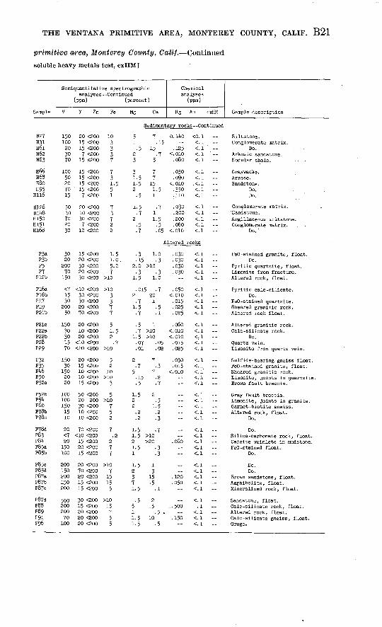
TABLE 1. Analyses of samples from the
[Parts per million, ppm; citrate
Semiquantitative spec'trographicanalyses
(ppm)
Sample Ti Mn Ag Ea Be Zr Co Cr Cu La B Mo Ga Kb Sc Ni Pb Sr
Metaraorphic rocks
PIP2
Pll*P18P30
P33P37P38P39P51
P6iP92P97P98
P105
P133P153P15^P^.88bPlOJi
P217?219P221P223P227
P232P23UP235P268P273
P275P276bP277aH32?,^2£tHU6H71H72H78
Hl35b
2,000200
10,0002,0001,500
7,000700
15,0003,0003,000
5,000700
10,0001,500
150200
10,0007,0007,0007,000
5,0001,000
>10,000150
5,000
7,0001,0001,500.5,0005,oop
. 7,0005,0005,000
>10,000300.
5002,0005,0005,000
500
500 <1100 <1
2,000 <170 <i300 <l
1,000 <150 <i
1,000 <1150 <1300 <. 5
300 <. 5300 <.5200 <. 5700 <. 570 <5
700 <. 52,000 <. 5
300 <. 51,500 <. 5700 <. 5
1,000 <. 5to <3
2,000 <. 51,500 <. 53,000 <,5
200 <. 5700 £.'5'50 <.'5200 <". 5100 <. 5
100 <. 5200 <. 5150 <.5
1,500 <.510 <. 5
70 <.5300 <. 5300 <.5
1,500 <. 550 <-5
500 <a70 <l
100 <1100 <1
1,000 <1
1,500 <i150 <1200 <1500 <170 i
100 170 <1
1,000 <120 <1
1,000 <1
<10 <1150 <1
>5,ooo <i70 2
1,000 2
700 11,000 1700 2<10 <170, <a
1, 500 270 1300 150 <1
500 <1
2,000 <1" 70 <i1,500 <i
150 170 <L
1,000 11,500 i
300 110 170 1
--_.--
__----
100
15030100<10<10
<io20030050
300
}00150300<10150500"70
200150200
10015020010015
5.0300150100700
10<330<3
5
3035015<5
5<51050<5
100100
510010
50<530705
105
<5<5<5
<5<5<570<5
<5<5<50100<5
7020301010
705
7003020
1005050
1,5005
3,0002001507007Q
15020300
2,00050
79150'20
200200
20010010070030
57
3015010
50 50 - <37 <30 -- 15
70 30 - <37 oo - <3
20 <30 <3
20 <30 -- <37 <30 - <3
70 30 - <350 30 -- <320 20 <10 <2
100 30 100 <27 <20 <10 <230 70 <10 <230 <20 <10 <2<2 <20 100 .<2
3'<20 15 <270 <20 <10 <220 30 <10 <230 <20 10 <230 <2.0 <10 <2
50 70 10 <230 20 <10 <250 50 <10 <210 <20 <10 <23 20 10 <2
30 150 <io <2"7 20 10 <230 <20 <10 <270 20 <10 <2100 20 15 <2
30 30 10 500100 2'0 10 150200 100 10 200100 20 10 <2<2 <20 <10 <2
50 <2Q <10 <27 50 <10 <2
30 20 <10 <25 <20 <10 <2
50 <20 <10 <2
._----
.._----
<10
10<105015
<10
<io3020.2020
70
303020
3010
<10<10<10
15<10io20<10
20151010<10
10 <10 10
<10 --<10 --
<10 --<10 15 --10 ---- 5
-- 10- <5 20- 30- <5
-- 7- 30-- 15- 30 20
- 30- <5- 30-- 7-- 7
-- 7- 7- <5-- 5-- 10
-- 20 . 15-- 20- 30- <5
- <5- <5-- 7- 50- 15
20<3305
10
303
200205
30 307
1003
5,0005030
1007
50770
1,50030
70 30
. 72020
10300100702
527
2003
15 100<10 3,000<io 300<10 20<10 200
<10 100<10 20<io 300<ao 50<10 <50
15 1,00010 700'20 500<10 200<io 300
<io <50<10 20020 300
<ao 30015 1,000
20 7020 5020 500
<io <50<10 70
20 30010 5,00020 <50<io 50<10 100
20 1,000<io 50<10 20010 300
<10 1,500
30 70030 50015 150
<io 500<io <50
Intrusive rocks
E6?i5a?l&bP15c?3it
PlfgF^3ffypE|jf?Wa
EM3bEwE9tv595PiOO
3,OQO§>poo
16; ooo10, §00
2QO
10,000r-
1,5,00iQ, ,600" "T9
§q'--__
3,000'OQ
300 <17QO <13QO <1300 <1
1,000 <1
700 <.5 <. 1
100 <.§1,0@6 <. 5
' 20 «i '
2Q <1?-. < !-- <. 1
1?Q <,5300 <,5
1,500 1.5700 i700 1700 1200 <1
200 <1150 <1
1 4 5QQ 1,51,000 1
70 <1
300 <11,000 21,500 13,000 <1<LO <L
150200--
3050ISO150--
. *3002OO70ao
51530503
5070<520<3
<31510<5100
750
100150
7
5001,000
<5701
170507
3,000
5 70 <315 30 -- <330-'<20 <10 <270 <20 <10 <27 30 -- <3
30 <20 <10 <2200 <30 <3o <310 50 <10 <210 50 <10 <220 <30 -- <3
7 <30 -- <315 70 <30 <310 TO <3O <330 70 <10 <22 <20 15 <2
2020--
30103030
__151520<10
10 --<10 10-- 15
<10
- 30<3 50- <5-- 20
<10 --
<10 --7 15
10 20-- <5-- 7
<31530307
30150<27
<3
<3<30<30
73,000
15 500<io 30015 30020 300<10 70
<10 1,50015 20050 1,00010 1,000
<10 <5
<10 3015 50030 50050 2,000
<io <50

THE VENTANA PRIMITIVE AREA, MONTEREY COUNTY, CALIF. B17
Ventana primitive area, Monterey County, Calif.
soluble heavy metals test, cxHM]
Sample
Semlquantitat analyse
(ppm)
V Y Zn
ve spectrographic Continued
(percent)
Fe Mg Ca
Chemical analyses
(ppm)
Hg Au cxHM Sample description
Metamorphic rocks
PIP2
PlUPl8P30
P33P37P38P39P51
P6iP92P97P98P105
P133P153P154Pl88bPigit
P217P219P221P223P227
P232P23'tP235P268P273
P275P276bP277aH32RkSa
Hl»6H71H7SH78Hl35b
15010
5002030
300.105007020
5010050
10050
15200150200100
50151001570
702010
300200
5,00050050015010
101530
15010
20 OOO<10 OOO50 ooo
<10 OOO10 OOO
30 ooo<10 OOO30 ooo10 OOO5 ooo
15 ooo7 oeo20 OOO7 ooo
<5 ooo
<5 ooo20 OOO20 OOO15 OOO30 ooo
30 ooo<5 ooo20 OOO7 000
10 OOO
15 ooo7 ooo5 ooo
20 00015 ooo
30 ooo20 30020 OOO10 OOO<5 <soo
<5 ooo7 <3oo
15 ooO30 ooo5 ooo
3-
>1011.
7
732
3175
7155
107
711037
531.53
25510
&3
10
03
5
7
1
5
5
7
7
1.
5
1
3
71
25277
107353
2
10101.
21.
11
153
.15
53
3
15
2
5
5
57
55
57
2
0.>10
7
1
7
7
10>20
310
>eo
151
1010
77
15
3>eo
21.
22210
>20
211.
101
7
15
07
157
5
33
1
5
5
67
o. 025 <o. i<. 010 < 1
. 030 < 1
.015 < !<. 010 < 1
C 010 < 1C 010 <- 1.025 < !C 010 <- 1.150 ci
. 130 c i..010 ClC 010 C 1.030 ci.030 ci
.070 <.l
.100 Cl
.060 ciC010 .2.080 ci
. 030 c i
.020 -2
.070 c iC 010 C 1.020 Cl
.320 <.lC010 .2
. 010 . 3_---- --
i._
<. 010 . 2.030 ci
.080 ci
.080 c i
.020 <. 1 020 <-l,150 c-i
Graphitic schist. Graphitic marble.-- Amphibolite. Cordierite (?) -bearing gneiss. Quartz -feldspar gneiss.
Amphibolite. Quartzite.-- Amphibolite. Migmatitic mica schist. Quartzite.'
Calc-sllicate gneiss. Graphitic marble. Biotite -quartz -feldspar gneiss:-- Amphibolite. Graphitic marble, float.
Ifeflc dike. Blotite amphibolite. Biotite -quartz -feldspar gneiss. Amphibolite. Biotite -hornblende orthogneiss.
Garnet -silllmanite schist. Quartzite. Garnet mica schist. Calc -silicate rock. Garnet diopside rock, float.
Biotite -quartz -feldspar gneiss. Calc -silicate rock. Quartzite. Sulfidic graphitic gneiss.
Do.
Do.Do.Do.
Biotite amphibolite. Graphitic marble.
-- Quartz -feldspar schist. Feidspathlc quartzite.
Do.-- Amphibolite.-- Quartzite.
Intrusive rocks
P6P15aPl5bi?l5c?3Upi*2P43pit 5PkjPTO
Pl(8bP82P9^
PlOO
70200150150<7
150100101.9<r<77070'20
15
15 06636 0001J5 <200io ooo30 ooo
10 OOO10 <1007 000
15 ooo<10 OOO
<10 OOO30 <10030 <100$ oob
<5 ooo
25
1072
7--
7
1. 7
7
02
03
5
1.32
7
3
--
10
75
3
3
01
01
7
13.1.1.
15
27
..
0553
015
1
7 05
.015 Clcoio -5.020 < !.020 < 1C 010 < 1
. 030 < 1_
. 050 < 1
.080 < 1-. <.l
Cl__
. 040 < 1
.170 -1
Porphyritic quartz monzonite. Foliated quartz diorite.
Do.Do'.
Leucogranite.
Hornblende diorite. Hornblendite. Graphic pegmatite.-- Granodiorite. Quartz core of pegmatite.
DO.'- Granodiorite. Quartz diorite."-- Pegmatoid quartz monzonite. Serpentinite.

B18 STUDIES RELATED TO WILDERNESS PRIMITIVE AREAS
TABLE 1. Analyses of samples from the Ventana
[Parts per million, ppm ; citrate
Semiquantitative spectrographicanalyses(ppm)
Sample Ti Mn Ag Ba Be Zr Co Cr Cu La B Mo Ga Hb Sc Ni Pb Sr
Intrusive rocks Continued
P129P13UP135PiW*P151a
P151bP151cP186P222P290
H4H5H6H7Hlta
H23H2l>H28H38bH39
H40Hl*9H5l*H58H69
H76H77
H135aH138H139
mvrH159Hl6lHl62H173
H174Hl80Hi85
P23P2l»P25P26aP26b
P90P125P17UP185P191a
P193psUsHl8aHl8bH26
10010,000
.-
1,000
70030070_.
1,000
30010,0007,000
>10,0001,500
100500
5,000150--
150200
2,000150
5,000
..150
300100
700300
3,000300
1,500
3001,500
3,0002,0003,0002,0003,000
3,0005,0001,0001,500300
T,ooo7,000
5001,0003,000
300 <0.5 l300 <.5 <.l 1 <.l
150 <-5 1
200 <. 5100 <. 5 i
2,000 <-5 1 <.l 1
200 <. 5
150 <-5700 <. 5 1700 <.5
1,500 <.5 i1,000 <. 5
2,000 <. 570 <. 5 >5100 <. 5 2300 <. 5-- <.l 1
100 <. 5150 <-5150 <.5500 <-5
l,ooo <. 5
<.i l700 <-5 <.l
1,000 <.51,500 <.5
150 <-5300 <.5
1,500 <.570 <-5300 <.5
300 <.5300 <.5 <.i 1
500 <1500 <i
1,000 <L500 <L500 <i
300 <L300 <.5 i300 <. 5 1150 <.5150 <.5
X50 <- 5 1150 <.5100 <a 2200 <1500 <1
,500 <1500 i.,000 1100 <1,000 1
200 3,000 1,000 1,500 <a200 <1
700 1,500 <L100 2,500 <i20 <1
20 <1,000 1,000 3<10 <1,500 i
150 1500 3700 1<10 <1500 i
,500 l10 <L150 <1<10 1700 2
300 1.<10 <1
' 15 <1700 1150 7
150 1700 2,500 2
500 2500 <i500 i.700 1.500 i.
700 l,500 <i,000 <1300 <i700 1
,000 1700 3,000 <L700 <1500 <1
105 100
3001020
7050
150150<10
2015020010010
<1070300<10200
<10>1,000
20<10150
150<1020<1030
5 15<LO1510070
70300200
St
,-555
_1003010070
200150.- --
<5201050<5
<5<5<5<1<5
<5207
70100
100<5<5703
<5<5<510050
310020100<5
<5150150<510
<5<5<1
"dime
157
207T
107
.<5<5<5
75
<33
15
<52030
1005
<51520<370
701003020
3,000
>5,ooo150 <5
3,0007
5155
. 2,00050
<33,000
5003,000
<5
<53,0003,000
<520
<555
ntary roc
15050
1005050
50150150155
150705
10150
7 20 <10 <2 157 150 <10 <2 307 70 <30 <3 15
70 <so <30 <3 1515 20 <10 <2 20
20 <20 <LO <2 1550 20 <10 <2 3030 20 10 <2 152 30 <30 <3 155 <20 <10 <2 <10
10 <20 <10 <2 107 50 <10 <2 2030 20 <10 <2 2030 50 <10 <2 20
100 <20 30 <2 <10
2 <20 10 <2 <105 100 <10 <2 20
20 70 10 <2 3010 <20 10 <2 <103 30 <30 <3 15
30 20 <10 <2 <107 20 <10 <2 157 50 <10 <2 15.7 <20 70 <2 <1015 <20 <10 <2 20
. 7 70 <30 <3 1015 <20 <10 <2 <10'50 <30 <30 <3 155 <20 <10 <2 <10
50 <20 <10 <2 20
7 <20 <10 <2 307 <20 70 <2 50
150 <20 10 <2 <1020 30 <10 <2 1570 300 15 <2 15
30 30 <10 <2 1520 30 10 <2 305 30 <30 <3 20
:ks
70 50 -- <3 -7 50 - <3 -50 50 - <3 --7 30 -- <3 --10 30 - <3 -
30 50 - <3 --20 50 <10 <2 303 20 <10 <2 <1050 <20 <10 <2 103O <20 <1O <2 <1O
30 70 70 <2 7020 50 70 <2 3010 <30 <3 --10 30 -- <3 --30 <30 - <3 --
- <5- 157 15
<3 50-- <5
-- 5- <5 10<3 -a- - <5
- <5-- 15- 15-- 30- 15
-- 5- <5-- 5- <57 <1
- <5- <5-- 5-- 7- 30
5 5-- 7<3 30-- 7-- 5
- <5-- 7- 50- <5-- 15
- <5-- 75 5
10 10 10 --10 --10 --
<10 -- 10-- 5- <5 <5
30-- 15
<LO --<10 --<10
220<30<30
2
33
20<3015
30557
700
3,00073
3,000<30
333
3,00010
<302,000
1003,000
3
203,000
3003
15
22
<30
7020702030
1573
<25
2020<33
50
70<102010
100
501507070
<10
50151515
<10
<107030
<1030
151070
<1010
50<1010
<1050
150<10<107030
503020
1510151010
10201030
50501010
<10
150300500300700
200700300200
1,000
3001,500
3002,000<50
501,500
500100300
50500300<50700
300<50200<50300
150<5050
300300
100100150
150100150200200
2001,500
700<505°
300150150100100

THE VENTANA PRIMITIVE AREA, MONTEREY COUNTY, CALIF. B19
primitive area, Monterey County, Calif. Continued
soluble heavy metals test, cxHM]
Sample
Serai quantitativ analyses-
(ppm)
V Y Zn-
e spectrographic -Continued
(percent)
Fe Mg Ca
Chemical analyses
(ppm)
Hg Au cxHM Sample description
Intrusive rocks Continued
P129PIS'*P135
P151a
P151bP151cP186P222P290
HitH5H6H7Hl4a
H23H2UH28H38bH39
HUOHl*9H5>*H58H69
H76H77
H135aH138H139
Hll*7H159Hl6lHl62H173
H17UHl80Hl85
10707050010
101010<130
<107050
15030
201020
<1010
<lo<LO1515
150
730
10015
<10
<101570
<1030
<1010<1
7 <20015 <20030 <ioo15 <aoo7 <200
10 <20015 <2005 <200
15 <10010 <200
<5 <20015 <20015 <20015 <2005 <200
<5 <2007 <20010 <200<5 <20010 <100
7 <20010 30070 <200<5 <2005 <200
30 <100<5 <20015 <ioo15 <20030 <200
7 <200<5 <2007 <2005 <200
30 <200
15 <20015 <20020 <100
110.__.7
1.512_.1.5
i75
1015
.7
.533
.15
.72710
__7
101.5
.7101513
13--
2-,
-1
317
10
10
7-
103
.10-
10
>1010
2
-
.15
-_.7
.7
.5
.5-
.7
5
.7
.7
-
.15
.5
.7
.
-
.15
.7
.2
.15
.7-
--2 1
121
10
1103
15i
.22.5
15--
.21127
_2
15.7
.7
.0715
.75
.71
0. 010 <0. 1.020 <.l
.620 <.l
.230 <.l
.120 <. 1
.040 <.l --
.120 <.l
.030 .2
.020 <.l --
.100 <.l
.QUO <.l
.200 <.l
.010 .1
.020 <.l --. 070 <. 1
<.010 <. 1.020 <.!
<.010 <.l.030 <.l.010 <.l
.010 <.l
.070 <. 1
.070 <. 1
.050 <. 1
.100 <.l
.100 .2
.020 <.l
.100 <.l
.010 .3
.050 .5 ---
Pegmatite.Quartz diorite.Granodiorite.Hornblende gabbro.Pegmatite.
Pegmatite.Do.
Garnetiferous alaskite.Pegmatoid granite.Green -stained granite.
Biotite quartz monzonite.Granodiorite .Foliated granodiorite.Gabbro.Peridotite.
Serpentinite, float.Pegmatite, float.Leucogranite.Serpentinite, float.Biotite granite.
Pegmatite .Do.Do.
Serpentinite.Quartz diorite.
Garneti'ferous biotite granite.Peridotite.Gabbro.Peridotite.Granite.
Pegmatite.Serpentinite.Peridotite.Pegmatite .Pegmatite, float.
Pegmatite.Granodiorite.Quartz monzonite.
Sedimentary rocks
P23P2l*P25P26aP26b
P90P125P17UP185P191a
P192P2U2Hl8aHl8bH26
15030
15070100
10050101510
150701515
150
30 <200 515 <200 230 <200 520 <200 315 <200 3
15 <200 320 <200 57 <200 3
<5 <200 i. 55 <200 .7
15 <200 715 <200 5
<10 <200 .710 <200 120 <200 5
2.7
1-51.52
1.527.1.15
22.7.5
2
.7
.1
.5
.5
.5
.35
20.15.07
1.7.1.2.7
.015
.015
.025<.010<.010
.030.050
<.010<.010
.100
.050 --
<.l<. 1<. 1<. 1<.l<. 1<. 1<. 1<. 1<. 1
<.l<. 1<. 1<. 1<.l
Gray sandy siltstone. Sandstone.
Do. Conglomerate matrix.
Do.
Do. Do. Do.
Sandstone. Do.
Light-gray siltstone. Gray claystone. Sandstone.Conglomerate matrix.
Do.

B20 STUDIES RELATED TO WILDERNESS PRIMITIVE AREAS
TABLE 1. Analyses of samples from the Ventana
[Parts per million, ppm ; citrate
Semiquantitative spectrographicanalyses(ppm)
Sample Ti Mn Ag Ba Be Zr Co Cr Cu La B Mo Ga Nb Sc Ni Pb Sr
Sedimentary rocks --Continued
H27H31H6lH62H63
H66H68H80H95
Hll6
H126ElbaH150H151Hi68
P3aP3bP5P7
P12b
Pl6aPl6bPI?P19P21b
P21CP22aP22bP28P29
P32P35PU6P50P52a
P52bP5^P6oP78bP78c
P?8dP83P8UP85aP85b
P85cP85dP87aP87bP87c
P87dP88P89P91P96
1,0002,000
>10,0007,0007,000
>10,0007,0003,0007,0005,000
7,0005,000
10,0005,0005,000
1,5001,5003,0001,0005,000
5005,0003,0005,0001,500
5,0001,0002,000
700700
5,0001,500
10,000700
1,500
5,0005,0005,0001,0001,000
3,00050
3,0003,0002,000
5,0007,000
>10,000>10,000
3,000
10,000>10,000
7,00010,0003,000
1,500 <0.5300 <1300 <. 5
1,000 <. 5300 <.5
1,500 <. 51,500 <-5150 <-5300 <. 5100 <. 5
300 <. 5300 <. 5
2,000 <. 5150 <.5100 <. 5
150 <i200 <1700 <1150 <1300 <i
30 3500 <. 5
1,000 <1300 <i700 <1
150 <l300 <i300 <1100 <115 <1
500 <1200 <1
1,500 <-5700 <1300 <1
1,000 <11,500 <i1,000 <1
500 <i150 <i
700 <1150 <1
3,000 <. 5500 <1300 <1
1,500 <i1,000 <13,000 <.53,000 <. 5300 <i
700 <i2,000 <. 51,000 <1
300 <. 5500 <1
1,500 21,000 <1
700 <11,500 21,000 <1
1,000 <12,000 <11,500 i1,500 i3,000 1
1, 500 2i, 500 i700 2
1,500 2200 2
1,000 1.5150 1
1,000 1700 1500 <i
20 <1100 130 1.5
2,000 i.$100 i. 5
1,500' 1.570 <130 <1
100 <1200 <1
700 <12,000 <11,500 i200 1
1,000 1
500 1200 1700 <1
1,000 1.51,500 <i
1,000 1.515 <1
200 i2,000 1.52,000 1.5
300 <11,000 3
300 21,500 1
500 1
150 <1300 <1150 <1500 3500 i
300 50-- 10
300 <5150 15100 10
100 2070 <5
150 <5150 570 <5
300 550 <5
150 70100 <5200 <5
Altared.-- 3-- <3-- 15-- 5-- <3
- .1501,000 <5" f-- 10- 15
- 7-- 3-- 5-- <3" -13
-- 15-- <3
100 15- 15-- <3
-- 10-- 10-- 10-- 3- <3
3-- <3
100 <5- 15-- 15
-- 15-- 7
150 70150 70- 5
-- 50150 100- 15
500 30-- 15
3005030
150500
15010015150
5
3015501050
_ro_cKs
3020503
TO
-3 1.)1003015030
22036 to15
1507
70302
15300100ii
1.53
7010050
10050
i,5oo2,000
30
702015
15020
30 50 50 <220 <30 <370 150 <10 <27 30 <10 <2
70 50 15 <2
70 20 <10 <230 30 <10 <25 70 <10 <2
30 30 <10 <2? 30 <io <2
50 30 20 <250 50 <10 <230 50 30 <230 30 <sio '<s.3d 50 10 <2
20 50 -- 53 30 -- <3
30 50 --* -<350 30 - J70 50 -- T
JoO <30 -- 710 150 <io <s50 30 - <350 70 5
150 <30 -- <5
50 |6 -- %3 13 3"6 --.<316 30 -- <37 <30 <3
300 <30 -- <7
70 50 - <33 50 - <37 30 <10 <2
150 <30 <53 70 -- <3
7 30 - <37 50 " <5
50 150 - <35 <30 - <37 <3o -- <3
2 70 -- <330 <30 - <315 70 15 <250 70 -- <3
300 30 -- <3
70 <30 - 350 100 -- <350 30 50 <2
150 30 150 <2100 <30 -- <3
70 <30 <3300 100 10 <220 70 -- <370 50 10 «2
300 §0 -- <3
30 152030
2030103020
3015lo1510
..-- ii
10----"-_-
..__-- ..--50----..--..----_--10 ....2020--
..20.»15--
- 3010 - 15- 15 20
20-- 15 7- 15- <5
-- 10 - - 7- 15 <5-- 7
<10 --10 --
<16 --§io --30 -
<10 -- 1010 --10 -16 ---
10 '--<10 --10 --
<10 --<10 --
10 --<10 ---- 20
<LO --<10 -
<10 -10 --30 -
<10 -
15 --<10 ---- 1530 -
<10 -
<10 --100 --- 30- 50
<10 --
<10 -- 303& ---- 15
70153
3070
307
<27"<2
3^702
20
74315<3<3
2005
so3§30
<37
103
15
50<37
30<3
<31510<3<3
<3<373020
151010015020
303010 305
3010203020
155030205b
2020302015
ie10103"o
<1015
<1830
<10
20<10<10<10<10
1020301510
10<10101010
<10<1030
<10<10
<10<10sois
<10<lo<10-3:o<ao
700100150300
1,000
50076o3bb300
1,000
job300300150<50
§9930
500200200
201,006
7020030
200100150107
500300
1,00030
1502010020070150
150300300200150
3020020030030
e'eei',-?06
150150150
THE VENTANA PRIMITIVE AREA, MONTEREY COUNTY, CALIF. B21
primitive area, Monterey County, Caii/. Continued
soluble heavy metals test, cxHM]
Sample
Semiquantitati analyses
(ppm)
V Y Zn
ve spectrographic Continued
(percent)
Fe Mg Ca
Chemical analyses
(ppm)
Hg ,Au cxHM Sample description
Sedimentary rocks --Continued
H27H31H6lH62H63
H66H68H80H95Hll6
H126H1U8H150H151Hl68
150100203070
10050207015
5030702030
20 <20015 <20015 <2007 <200
15 <200
15 <20015 <20015 <20015 <2007 <200
20 <20010 <20030 <2007 <200
10 <200
103337
731.551
73722
5 71 .15.5 15
2 '.73 ' 5
3 71-5 71.5 152 1.5
5 1
1.5 .7.7 1
2 1.5 5 -5.7 .05
0.140 <0. 1<. 1
.125 <-i ' --<.010 <.l '.080 <.l
.030 . <. 1
.090 <. 1<.010 X.I.350 <.l -.110 <. 1
.030 <.l
.200 <. 1
.200 <. 1
.060 <. 1<. 010 <. 1
Siltstone.Conglomerate matrix.
'Do. ,Arkosic sandstone.Nodular shale.
Graywacke .Arkose.Sandstone.
Do.Do.
Conglomerate matrix.'Sandstone.Argillaceous siltstone.Conglomerate matrix.
Do. '
Altered rocks
P3aP3bP5P7
P12b
Pl6aPl6bPITP19P21b
P21cP22aP22bP28P29
P32P35Pk6P50P52a
PJ2bP$bP6oP78bP78c
P78dP83P8UP85aP85b
P85cP85dP87aP87bP87c
P87dP88P89P91P96
302020070
150
<71530
20050
15030301570
15030
1502020
1001001501510
20<720150100
200150200150200
50020020070100
15 <20020 <20030 <20020 <20030 <200
<10 <20030 <20030 <20020 <20070 <200
20 <20010 <20020 <200
<10 <200<1O <200
20 <20015 <20010 <20010 <20015 <200
50 <20020 20030 <20010 <20010 <200
70 <200<10 <20015 <20020 <20015 <200
20 <20070 <20020 <20015 <20015 <200
30 <20015 <20020 <20020 <20020 <200
1-51.0.5-07
>10
>103377
51.52
7>10
5210
>103
5>10
752
7.2
277
>107
15155
>1015755
.3 1.0
.15 -32.0 >10.3 -3
1.5 1.0
.015 .72 20
7 11.5 -5.7 .1
.5 1
.7 >io1. 5 >io.07 .05.01 .02
2 7 7 -3
5 7.15 .2.5 .7
1-5 22 .52 l.'5.2 .2.2 .3
1.5 .71. 5 >102 >201.5 .31 .3
1.5 12 33 157 151.5 .1
5 25 151 -5 .1.5 10 '1-5 -5
.030 <. 1
.030 <.l
.030 <.l
.030 <.l --<. 1
.050 <.l<.010 <.l.015 < !.025 <-i -.025 <. 1
.060 <.l<.010 <.l <.010 <.l.015 <.i -.025 < !
.030 <.l
.015 < !<.oio <.i --
<. 1<. 1
<.l -<.l<.!'. --<.l<.l -<. 1<. 1
.060 <.l<. 1- <.l -<.l<;_!
.120 <.l
. 050 <. 1<.l
<. 11.500 .1
<. 1.150 <. 1
<. 1
FeO -stained granite, float.Do.
Pyritic quartzite, float.Limonite from fracture.Altered rock, float.
Pyritic calc -silicate.Do.
FeO -stained quartzite.Sheared granitic rock.Altered rock float.
Altered granitic rock.Calc-silicate rock.
Do.Quartz vein.Limonite from quartz vein.
Sulfide-bearing gneiss float.FeO -stained granite, float.Sheared granitic rock.Limonite, joints in quartzite.Brown fault breccia.
Gray fault breccia.Limonite, joints in granite.Garnet -biotlte gneiss.Altered rock, float.
Do.
Do.Silica-carbonate rock, float.Calcite veinlets in mudstone.FeO -stained float.
Do.
Do.Do.
Brown sandstone, float.Amphibolite, float.Mineralized rock, float.
Sandstone, float.Calc-silicate rock, float.Altered rock, float.Calc-silicate gneiss, float.Gouge.

B22
TABLE 1.. Analyses of samples from the Ventana
[Parts per million, ppm; citrate
Semiquantitative spectrographicanalyses(ppm)
Sample 1i Mn Ag Ba Be Zr Co
Altered rocks
P99PlOlaPlOlbP102bP103b
P10UP106PllOaPllObPllOc
PllTbPllSbP121aP121bP121c
P122P123PI PitP126P127
P128P130P131P132P136
P137P138P139PlltOaPll»0b
P1U2Pl47aPlUTbP1U8PlUga
PlUgb
7007,0003,0003,0005,000
1,0002,0007,0001,000700
10,000>10,000
3,000>10,000
7,000
10,000300
7,0001,5001,500
3,00010,000
2003,000
10,000
10,00010,000
>10,000>10,000>10,000
1,500>10,000
1,00010,0007,000
2,000PlU9c , 10,000P150a P15ObP152
Pl6lPl62aPl62bPl63aPl63b
Pl63cPl64aPl6UbPl64c^P165
' 3,000>io,ooo10,000
5,0007,000
>10,00030300
10,0001,000
, 10,000' 5,000
1,500
70150150100300
7015030030
100
300300100300300
3003,000
150100500
3001,500
1501,000
300
300300
1,0001,000.1,000
1501,500
100700500
300500150
1,500300
10070
1,500150700
150700 70150100
<1 70 <l1.5 3,000 i<5 70 1<. 5 1,500 2<.5 2,000 1
<. 5 700 2<. 5 700 1<. 5 1,500 2<.5 >5,000 <1<. 5 >5,000 i
<-5 70 1.5<. 5 1,500 <i<. 5 300 2<. 5 1,500 i<. 5 1,500 i
.5 2,000 2<-5 50 1<. 5 300 2<. 5 500 i<. 5 200 1
<. 5 200 1.7 1,500 2
<. 5 2,000 1<. 5 >5,ooo 3<. 5 700 1
<. 5 i, 500 2<. 5 1,000 2<. 5 700 i<. 5 700 2<.5 150 l
<-5 700 7<. 5 500 2.5 1,500 i
<.5 1,000 1<-5 3,000 1
<.5 3,000 i C5 1,500 2<. 5 3,000 2<. 5 300 <a<.5 1,500 i
3 1,000 iC5 500 2<.5 10,000 3<.5 10 l<.5 150 i
2 5,000 1<-5 70 2<-5 1,500 l.5 700 2
<. 5 700 l
_300200200200
30070703030
150300200300300
500101005070
703001070
200
200150300700100
7010050
30015015030030020150100150200<1015
1503030015050
15<5<5<5<5
<5<520<520
2070 1,<5<5<5
7<510<5<5
<550<51010
10155
3010
<570<555
<55
<5705
<5<530<5<5
<5<5<5<5<5
Cr Cu La B Mo Ga Nb Sc Ni Pb Sr:
Continued
157015<550
305
1002030
150000so70
100
15015301515
303001515030
707030
20020
15205
150100
705
<52015030
100200<515
150201007010
20 <30 -- 15 -- <1030 20 10 <2 15 15 <20 <10 <2 <10 --20 50 <10 <2 20 --10 50 <10 <2 50
10 50 <10 <2 15 --30 20 <10 <2 10
100 20 30 30 30 --50 <20 <10 7 30 20 <20 <10 10 20 --
30 30 <10 <2 20 50 70 70 <2 70 --
150 30 70 5 15 --150 <20 70 <2 50
5 30 30 <2 20 --
70 50 <10 <2 30 5 <20 <10 <2 <10 --
50 20 15 <2 20 --7 <20 <10 <2 <10
100 20 10 <2 <10 --
30 <20 15 <2 10 100 <20 <10 <2 30 --
3 <20 10 <2 <10 --10 30 20 <2 10 5 100 <10 <2 30 --
7 20 <LO <2 30 20 20 10 <2 70 --5 70 10 <2 30
30 20 15 <2 70 3 100 30 <2 30 --
70 30 70 7 30 30 20 <10 <2 70 7 <20 <10 <2 20 --
70 50 <10 <2 30 --20 30 <10 <2 30
7 20 <10 <2 20 --10 <20 15 <2 30
100 3O <10 2 20 --15 <20 10 <2 20 20 50 <10 <2 30
30 <20 10 70 20 --30 30 150 2 30 --70 30 10 <2 30 --<2 <20 15 <2 <10 15 <20 <10 <2 <10
50 30 <10 3 15 --5 <20 10 <2 <10 50 30 10 5 20 70 50 <10 2 20 --7 <2O <1O <2 <10 --
__155
<57
10<530<5<5
20505
1510
15<57
<5<5
730<51010
151573020
530-<52015
515<53010
52030<5<5
155
1510<5
<37
2057
55
303
20
30150
27
30
303775
77015707
7103707
7535
15
7<2<277
27
7027
710<255
<10100102020
3050203050
1520503030
50505020300
3015102015
3020
<101510
7030503030
5020301550
707030
<LO10
15010
30070015
1070
<50300500
50100500
1,50030
3002,000
150150300
3007007050
<50
100 150
200150300
30030030050015070
300300100
1,000
5001,500
500700
1,500
150100200<50<50
150<50100100<50
I/ Sample PlJOa contains 150 ppm W. All other samples contain less than 50 ppm W.
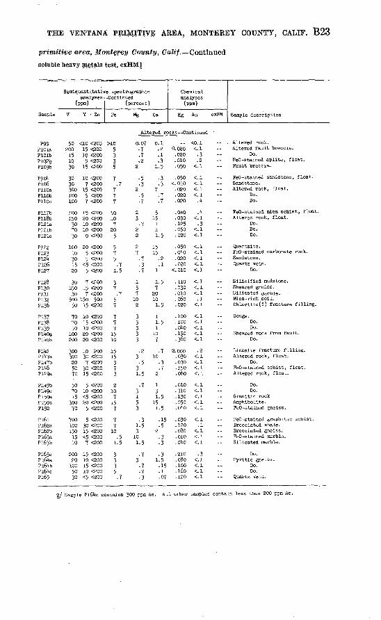
THE VENTANA PRIMITIVE AREA, MONTEREY COUNTY, CALIF. B23
primitive area, Monterey County, Calif. ^Continued
soluble heavy metals test, cxHM]
Sample
Semiquantitativ analyses-
(ppm)
V Y. ' Zn
e spectrographic -Continued
(percent)
Fe Mg Ca
Chemical analyses (ppm)
Hg Au cxHM Sample description
Altered rocks--Continued
P99PlOlaPlOlbP102bPi03b
PICAPio6PllOaPllObPllOc
PllTbPll8bP121aP121bP121c
P122P123P121*P126P12T
P128P130P131P132P136
P137P138P139Pi4oaPll+Ob
Pll*2PlltTaPlVfbPil*8Pll*9a
Pll*9bPii*9cP150aP150bP152
Pl6lPl62aPl62bPl63aPl63b
Pl63cPl61*aPl61tbPl6i*cPl65
50 200
151030
3630300ioo100
100150
307030
10010301520
30150
30
<10 <20Q15 <aoo10 <200
5 <20015 <2QO
10 <2007 <200
15 <2oo5 <2007 <pno
15 <20020 <20010 <20010 <20010 <200
20 <2005 <2005 <200
<5 <2005 <200
7 <20015 <2007 <200
500 150 50050
707050
100200
300300205070
507015
30070
700100150
1510
20020
1005030
15 <200
10 <20015 <20010 <20020 <20020 <200
10 20030 <200
7 <20030 <20015 <200
5 <20010 <200<5 <20020 <200
5 <200
5 <20030 <20015 <200<5 <200
7 <200
15 <20010 <20015 <20010 <200<5 <200
>10 0. 075335
7.7
777
1010
720
5
575.7
1.5
37.7
57
777
1510
1515
373
210
715
7
77
10.5
1.5
3335.7
2
2
23
22
27
137
102
33333
3'
31.
3153
1.3
10i.
3
772
53
57
7
737
2
5
5
,7
35
.5
7
77
.3
0.
1.
7
515
111.
1515
1
1.7
2010
1,
11.1
107
10
2
13i.
151.
2
1.
12135
33
77
.5
2,1
.5
.5
5
.7
.3
.7
.5
.5
.15
.5
.3
.3
.3,5.15,1.07
-. <0.020.020.010.050
.050<.010
.020
.020
.020
.040
.030 125,050.020
.050
.01*0
.020
.020<.010
.110
.030
.010
.060
.020
.100
.100
.oUo
.190
.360
2.000.030.030.150.060
.010
.310
.130
.050
.010
.030
.120
.080
.010
.01*0
.210
.080
.100
.160
.120
;o.i<.l.3.2
<. 1
<.l<. 1<.l<.l.1*
<. 1.3
<. 1<.l
<.l<.l<.l<.l<.l
<.l<.l<.l
.1<. 1
<. 1<.l<. 1<. 1<.l
.2<.l<. 1<. 1<.l
<.l<.l<. 1<.l<.l
<.l.1
<.l<. 1<. 1
.3<.l<. 1<.l<.l
, Altered rock.Altered fault breccia.
Do.FeO-stained aplite, float.Fault breccia.
FeO-stained sandstone,Sandstone.Altered rock, float.
Do.Do.
float.
FeO-stained mica schist, float.Altered rock, float.
Do.Do.-Do.
Quartzite.FeO-stained carbonateSandstone.Quartz vein.
Do.
Silicified mudstone.Sheared gneiss.Silicated garble.Mica-rich soil.Chloritic(?) fracture
Gouge.Do.Do.
Sheared rock from faulDo.
rock.
filling.
.t.
Limonite fracture filling.Altered rock, float.
Do.FeO-stained schist, flAltered rock, float.
Do.Do.
Granitic rockAmphibolite.FeO-stained gneiss.
FeO-stained graphiticBrecciated shale.Brecciated gneiss.FeO-stained marble.Silicated marble.
Do.Pyritic gneiss.
Do.Do.
Quartz vein.
.oat.
schist.
2/ Sample Pl61*c contains 300 ppm As. All other samples contain less than 200 ppm As.
B24 STUDIES RELATED TO WILDERNESS PRIMITIVE AREAS
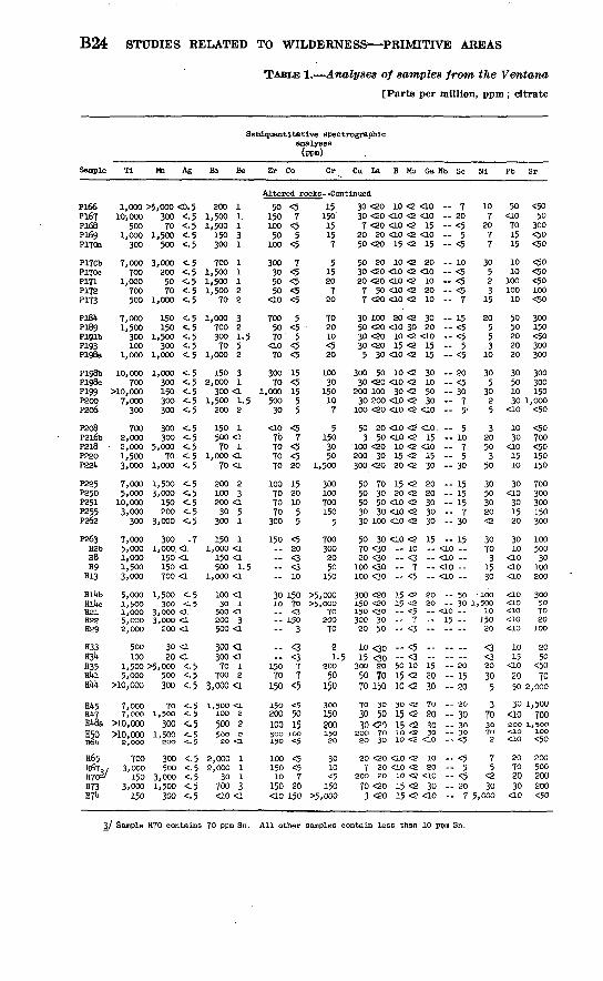
TABLE 1. Analyses of samples from the Ventana
[Parts per million, ppm; citrate
Semiquantltatlve spectrographlc analyses
Sample Ti Mn Ag Ba Be Zr Co Cr. Cu La B Mo Ga Nb Sc Nl Pb Sr
Altered rocks Continued
P166Pl£7P168P169P170a
P170bPITOcP171P172P173
PlSltP189Pl^lbP193P198a
P198bP198cP199P200P206
P208P2l6bP2l8P220P22U
P225P250P251P255P262
P263H2bH8H9H13
Hll»bHlUcH21H22H29
H33H34H35Hltl
HMt
Hl»5Hl»7H48aH50H61»
H65367H7C)3/H73H74
1,000 >5,000 <0.510)000
5001,000
300
7,000700
1,000700500
7,0001,500
300100
1,000
10,000700
>10,0007,000
300
7002,000
2,0001,5003,000
7,0005,000
10,0003,000
300
7,0005,0001,0001,5003,000
5,000. 1,5001,0005,0002,000
500100
. 300 <-570 <.5
1,500 <-5500 <.5
3,000 <-5200 <.550 <-570 <-5
1,000 <-5
150 <. 5150 <-5
1,500 <.5300 <.5
1,000 <.5
1,000 <.5300 <-5150 <-5300 <.5300 <-5
300 <.5300 <.5
5,000 <.570 <. 5
1,000 <-5
1,500 <.53,000 <.5
150 <.5200 <-5
3,000 <.5
300 .71,000. <1
150 <1150 <1700 <1
1,500 <. 5300 <. 5
3,OOO <L3,000 <1200 <1
30 <L20 <1
1,500 >5, ooo <- 55,000
>10,000
7,0007,000
>10,000>10,000
2,000
700/ 3,000
1503,000150
500 <-5300 <.5
70 <-51,500 <. 5
300 <.51,500 <;.5200 <. 5
300 <.5500 <.5
3,000 <.51,500 <.5300 <.5
200 11,500 1.1,500 i150 3300 i
700 i1,500 i1,500 11,500 2
70 2
1,000 3700 2300 1.570 5
1,000 2
150 32,000 1
300 <11,500 1.5200 2
150 1500 <i70 1
1,000 <170 <i
200 2100 3200 <130 5
300 1
150 11,000 <1
150 <1500 1.5
1,000 <1
100 <130 i
500 <1200 3500 <1
300 <1300 <170 1700 2
3,000<1
1,500 <1100 2
500 2500 sSO <1
2,000 12,000 1
30 i700 3<10<1
5015010050
100
300305050
<10
7005070
<LO70
30070
1,00050030
<ao70707070
100707070300
150 --
3010
..
.-15070150
150200100300 150
10015010
150<10
<57
<55
<5
7<5<5<5<5
5<5' 5<5<5
15<51555
<57
<5<520
15201055
<520<3<310
15070<3150
3
<3<377
<5
<55015
100<5
<5<57
20150
1515015157
51520720
702010<520
10030
150107
51503050
1,500
300100700150
5
7003002050
150
>5,000>5,OOO
7020070
21.5
20050
15030015020015020
3010<5150
>5,000
30 <20 10 <2 <1030 <20 <10 <2 <107 <20 <10 <2 1520 20 <LO <2 <1050 <20 15 <2 15
50 20 10 <2 2030 <20 <10 <2 <1020 <20 <10 <2 107 50 <10 <2 207 <20 <10 <2 10
30 100 20 <2 3050 <20 <10 30 2030 <20 10 <2 <1030 <20 15 <2 155 30 <LO <2 15
300 50 10 <2 3030 <20 <LO <2 10
200 100 30 <2 5030 200 <10 <2 30100 <20 <LO <2 <10
50 20 <10 <2 <10.3 50 <ao <2 15
100 <20 10 <2 <10200 30 15 <2 15300 <20 20 <2 30
50 70 15 <2 2050 30 20 <2 2050 50 <10 <2 3030 30 <10 <2 3030 100 <10 <2 30
50 30 <io <2 1570 <30 10 --20 <30 <3 100 <30 -- 7 100 <30 <5
300 <20 15 <2 SO15O <20 15 <2 2015O <3O -- <5 300 30 7 20 50 <3
10 <3o -- <5 --15 00 - <3 --
300 20 50 10 1550 70 15 <2 2070 150 10 <2 30
7O 3O 3O <2 7O
30 50 15 <2 2030 <PO 15 <2 30
2OO 7O 1O <2 30 2O 3O 10 <2 <1O
20 <20 <10 <2 107 20 <10 <2 20
200 20 10 <2 <1070 <20 15 <2 303 <20 15 <2 <10
-- 7 20- <5-- 5- <5
10- <5- <5 <5-- 7
-- 15- <5-- <5-- 5 <5
20 <5-- 30-- 7-- 5''
-- 5 10-- 7-- 5- 30
-- 15-- 15- 15-- 7-- 30
- 15<10 --<10 <10 --<10 -
50 30
<ao --15 ----
-. ..-- 20- 15-- 20
20-- 30 30-- 30 -- <5
- <5-- 5-- <5 20-- 7
1072077
30523
15
20553
10
305
3025
32050350
30503020<2
30703
1530
1001,500
1015020
<3<320
305
3703070 2
75
<230
5,000
50<10701515
1010
10010010
5050202020
30501030
<10
1030
<101510
30<10301520
3010
<10<10<ao
<1O<10<10<10<10
1015
<102050
30<io200
ss20702030
<10
<5050
300<50<50
<50<50<50100<50
300150<50300300
300300150
1,000<50
<50700<50150150700300300150300
10050030
100200
300507020100
2050
<5070
2,000
1,500700
1,500100 <50
200500200200<50
3/ Sample H70 contains 70 ppm Sn. All other samples contain less than 10 ppm Sn.

THE VENTANA PRIMITIVE AREA, MONTEREY COUNTY, CALIF. B25
primitive area, Monterey County, Calif. Continued
soluble heavy metals test, cxHM]
Sample
Semlquantitatl analyses
(ppm)
V Y Zn
ve spectrographic Continued
(percent)
Fe Mg Ca
Chemical analyses
(ppm)
Hg Au cxHM Sample description
Altered rocks--Continued
P166Pl67P168P169P170a
Pl70bP170cP171P172P173
P181*P189P191bP193P198a
P198bP198cP199P200P206
P208P2l6bP218P220P221*
P225P250P251P255P262
P263H2bH8H9H13
Hll*bHll*cH21H22H29
H33113!*H35Hl*lHlA
Hl*5HU7HU8aH50H6U
H65H67H70H73H7l*
30100105015
3020701570
10030101010
100151001515
1530150300100
2050
10050
15 <20010 <200<5 <2005 <2005 <200
5 <2005 <2005 <2005 <2007 <200
50 <200<5 <2005 <2007 <20010 <200
30 <2005 <200
15 <20010 <2007 <200
<5 <20010 <20020 <200<5 <2007 <200
15 <20015 <20015 <20010 <200
10 >200 <200
30030020
200150
1507030020050
15<730030
100
3010010010030
1015157015
30 <20020 <200
<10 <20010 <20020 <200
10 <2005 200
20 <200700 20020 <200
<10 <200<10 <20050 <20020 <20020 <200
10 <20030 <20010 <20020 <2005 <200
5 <20015 <20015 <20020 <200<5 <200
5513.7
5171.53
103713
71
1555
35
151015
310737
371.557
1015
>10>10
3
5.1
15107
151010102
.73
157
15
0.
1
1.
1.
3
31
131.
10
33
31
1.
107
1.1
313
3273
1.3
10
15715.71
,2,2.57
5.7,2,2 5
1
.3
,5.5
,7.7:7
.57.5
75
.0203
7
375
0.
2
11
1,7
1.21,2
3>20
10
201015205
72
1
153
215'
310
>2010
1.1.
>20
.7
.7
.7
.07
.15
.2
.07
.3
.5
.15
.5
.5
.5
.5
.7 3
.1
.7
.5,1.05
.02
.03
,2
.7
55
705
0.1*00 <0.1.500 <.i.220 .1*.200 .1.020 <-l
. 030 <. 1
.020 .2
.220 <.l
.130 <.l
.200 <.l
.050 .1
.130 <.l<. 010 <. 1<.010 <.l<. 010 <. 1
.200 <.l
. 200 <. 1
.300 <.l
. 070 <. 1<. 010 <. 1
. 210 <. 1
. 050 <. 1
.150 <.l
. 050 <. 1<. 010 <. 1
<. 010 <. 1. 200 <. 1
<. 010 <. 1<. 010 <. 1
. 030 <. 1
.060- .2
.015 <-i-- <. 1 <. 1- <.l
.020 <. 11.1*80 <.i <.l <. 1- <.l- <.l <. 1
. 070 <. 1
.200 <.l
.020 <. 1 '
<. 010 <. 1.020 <. 1. 030 <. 1.030 .2.020 <. 1
. Ol*0 <. 1
.020 <. 1
. 070 <. 1
.020 .2
.290 <.l
-- Quartz-siderite(?) gneiss. Granitic rock.-- Pegmatite. Quartz veinlet. Silicified gneiss.
-- Silicified gneiss.Do.Do.
Sheared argillized pegmatite.-- Limonite -quartz rock.
FeO-stained sandstone. Pyritic quartzite, float.-- Limonitic fracture filling.-- Argillized aplite. Fault breccia.
Do.Do.
Limonitic fracture coatings Sheared pegmatite. Calcareous quartzite.
FeO-stained pegmatite, float. Amphibolite. Fault breccia. Migmatitic mica schist.-- Limonitic calc -silicate rock.
Do. Fracture fillings in paragneiss, float.-- Calc -silicate rock.
Do.-- Argillized granite.
Gray gouge. FeO-stained schist, float. Limonite fault gouge.
Do.-- FeO-stained schist, float.
Weathered peridotite.-- Deeply weathered peridotite. Fracture filling in peridotite, float. Fracture filling in schist.-- Limonitic fault gouge.
Do. Quartz vein.-- FeO-stained schist. Limonitic fault gouge. Limonitic schist.
Do. Altered rock. Limonitic calc -silicate rock. Limonitic schist. Quartz vein.
Do.Do.Do.
Fault breccia. Serpentine in fault.

B26 STUDIES RELATED TO WILDERNESS PRIMITIVE AREAS
TABLE L^Analyses of samples from the Ventana
[Parts per million, ppm ; citrate
Semiquantitative spectrographicanalyses(ppm)
Sample Tl Mn Ag Ba Be Zr Co Cr Cu La B Mo Ga Nb Sc Ni Pb Sr
Altered rocks --Continued
H83H86H87'
H98H103
H166Hll8'H12711131*H137
HlltOHlUgH152Hl63H175
H176
300>10,000
2,0003,0005,006
7,-66o16 600'700
20030
130Jtf
5/ood10/000
300 <0. 5500 <.5150 <.5100 <-5
1,000 <.5
366 <,52,660 <<5
300 270 <'.570 </5
5,000 <-. $50 <-5
150 <.5700 <5
700' >5, 666 <. 5
10,000 5* <,$
1,000 1500 2
1,500 13,000 <1
300 1
1,000 <a1,500 1700 770 220 1
300 i<10 1700 3
1,500 270 3
30 <1
700300207070
300300<10<10<10
10<1015020050
30
<5207
<57
570<5<5<5
<5<5<5505
15
770105
70
100150
5150 i<5
5<550
50030
. 700
5 <20 <10 <2 10150 50 15 <2 5050 <20 <10 <2 3030 20 <10 <2 3050 50 10 <2 30
30 100 <10 <2 3020 50 10 <2 5020 <20 <10 <2 30
,000 <20 100 <2 30150 <20 100 <2 30
7 <20 <LO <2 205 <20 <10 <2 <10
50 <20 150 <2 70100 70 10 <2 50200 <20 30 <2 15
30 200 15 <2 30
- 7- 30- 5- 5- 30
-- 10- 30- <5- 7- <5
- <5- <5-- 10- 30-- 5
- 30
<2307
<220
10305
30<2
335
303
50
30151003020
3050
3,000<10<10
70101030
<10
15
70500
1,0001,5001,000
1,900500500<50<50
100<5070
300<50
100
Spring deposits
P116P177P190PH7P267a
150500
9,066T66"<10
15 <--5300 <.-5300 <-. 5200 <. 5i&> <-5
30' <1150 <1
1,000 1-156 4ifo 5
<itf16
10030
<io
<5<5<5<5<5
<51505020<s
<2 20 <10 <2 <103 20 70 <2 <LO
10 20 <10 <2 102 <20 <10 <2 <105 <20 50 <2 <LO
- <5- 5-- 7- <5- <5
<21573
15
<101020
<10<10
1,000300300500<50
Stream, pediments
P3PitP6P8P9
P10PliP12aP13P20
P21aP31P36Pl*0piti
pi*UP55P56P57P58
P59p"6g?4if§4P7§a
P§5eP86P93
P102aP103a
2,0003,ooo1,5005,ooo3,000
3,0003,0003,0002,0002,000
3,0003,0007,0003,000
10,000
3,0003,000
10,0007,0005,000
5,0003,0001,5001,5005,060
|,-S6§l',bdd2,900
10; 00010,000
300 <1300 <i200 <1700 <1500 <i
200 <1500 <1 .500 <1300 <1300 <i
700 <13,000 <1
700 <i700 <1700 <. 5
300 <i700 <1
1,500 <.51,000 <. 5
500 <1
500 <.5300 <1200 <1150 <1500 <i
f O'O <1|§§ <i
500 £i300 '<: 5366' <:5
700 1700 i
1,000 1.51,000 11,000 1
1,500 i1,000 11,000 1700 i700 i
700 i. 5500 <i500 <a700 <1700 3
700 <1500 <i500 3700 1500 <i
300 3500 <i700 <1700 <1700 i
500 i700 <LT&Q- 1785 f500 2
,,mm
---- - -------
_
----
300
..
300300--
300.-.--.--
..
.---
3003bd
7103
1510
5.7
1037
715201550
710201015
<5753
10
151010716
76100-30
loo100
7P36562020
307010070150
5050
200,70150<530305030
707050
100100
f 30 -- <3 -7 50 - <3 -7 36 -* <3 -
50 30 -- <3 30 50 - <3 -
7 30 - <3 -io 30 -- «3 --10 36 -= <3 f 30 --- <| ~7 <30 - <3 =-
,7 30 - <3 - --20 70 -- <$ 70 30 -- <3 30 70 - <3 --30 70 <10 <2 30
10 30 <3 20 <30 <3 30 70 10 <2 307 70 <io <2 30
20 <30 -- <3
3 50 <10 <2 2020 <30 -- <3 --15 <30 - <3 -15 <30 -- <3 --15 30 - <3 -
30 50 <3 --50 <30 <3 --7 50 - <3 -7 100 <10 <2 20
30 50 <10 <2 20
<10-<ao <io --<io --<lo -
<10 -10 --10
<lo _<10 --
io ==<10 --10 --10 -- 1®
_ ._<Lo _- 30 2010
-- 20<10 --<10 --<10 --<10 --
10 <10 --<10 --- 15 10
2020105050
1515151010
15go-To36§0
510301070
<21510107
2015152015
1010151015
1010101010
10<10<101015
16<101515
20101010
<10
<10<10101520
500500200200200
300200300200200
200200200200700
300l§630020015070
150100100200
200150150200150

THE VENTANA PRIMITIVE AREA, MONTEREY COUNTY, CALIF. B27
primitive area, Monterey County, Calif. Continued
soluble heavy metals test, cxHM]
Sample
Semlquantitati analyses
(ppm)
V Y Zn
ve spectrographic Continued
(percent)
Fe Mg Ca
Chemical analyses
(ppm)'
Hg Au cxHM Sample description
Altered rocks --Continued
H83H86H87H98
H103
H106H118H127«13l*H137
Hll*0H1U9H152Hl63H175
H176
Pii6P177P190YH7P267a
P3Pi.P6P8P9
P10PIIP12aP13P20
P21aP31P36pi*opltl
pltl*P55P56P57P58
P59P62P63P6UP78a
P85eP86P93P102aP103a
101001515
300
7015015
2007,00
101070
100100
150
1030301519
7010050
150100
TOTO1005050
7010020
15070
7010010030
100
15703030
100
1501501007050
50205
<520
1010101510
505
103015
20
<55
105
10
j
151510ao15
1515201515
15100302030
1520305030
301510
<ip15
2020201015
<200<200<200<200<200
<200<2001,500700500
<200<200200
<200<200
<200
<200<200<200<200500
<200<200<200<200^200
<200<200<200'<200<200
<200<200<200<200<200
<200<200<200<200<200
<200<200<200<200<200
<200<200<200<200<200
21035
10
771
>20>20
3 7
201015
10
.05331
10
23253
33312
37557
35775
7 3
225
75557
0.153.7
17
35.3.02
<.02
.2 05.7
3.15
5
.7511.05
i
1.5.7
21.5
11.51.5
7.7
11-531-53
1-51-5322
.71
5.5
1.5
21-51-522
i 0.060 <o.i722
15
735
07.1
.2
.15
.31
5
3
Spring i
>20>201520 <1.5
Stream
1.5
. 090 <. 1
. 050 <. 1
. 010 <. 1
. 050 <. 1
. 030 <. 1
.280 <.l
.020 <. 1
.090 <.l
.080 <. 1
.010 <.l
. 050 <. 1
. Ql*0 <. 1
.080 <,1
.150 <.l
. 050 <. 1Jepoaits
. 110 <. 1, 060 <. 1,080 <. 1. 010 <. 1"
sediments
. 015 <. 1
Fault gouge.Limonltic fault gouge.
-- "
..
.--.
Vein material.Fracture filling inFracture filling in
Altered rock, float.Fault breccia.Vein material.
granite.amphibolite.
Limonitic amphibolite.--
.. .,
Do.
Quartz vein.Do.
Limonitic slltstone.FeO-8tained amphibolite.
--
-
.»
.,----
13 <.010 <.l <. 51 .025 <.l3 <. 010 <.. 13 .015 <.l
2 <.010 <.l'.-7 ;.,6l-5 .<..!1 £1.5 <.1.5
1 <.1 <.3i <.3
1.51.531.51.5
11
7.5
1.5
2.7.5
1-51.5
. 010 < 1010 C ̂"!ois <'.i
, 010 <. 1010 <. 1
«-_^010 <. 1080 <.l <. 1
<. 1180 <. 1060 <. 1
<. 1
030 <. 1<. 1<. 1
<. 1
< 1<!i<. 1
100 <. 1oi*o <. i
.5s-6
.5131- c
<-51.5
22
.51312
312.511
11132
Do.
Limonitic gouge.
Travertine,Do.Do:DO,
Iron hydroxides.
Btream sediment;Do.Do'.
Da.Do.
Do,Do.Do.Bo.Do.
Do,Do.Do.Do.Do.
Do.Do.Do.Do.Do.
Do.Do.Do.Do.Do.
Do.Do.Do.Do.Do.

B28 STUDIES RELATED TO WILDERNESS PRIMITIVE AREAS
TABLE 1. Analyses of samples from the Ventana
[Parts per million, ppm; citrate
Semiquantitative spectrographicanalyses(ppm)
Sample
P108P109PllOdPillP112
P113P114P115P117aPlloa
P121dPl4lPll*3Pl^5Pli*6
P155P156P157P158P159
Pi6oP175P176P178P179
Pl8oPl8iPl82Pl83P187
P195P197P201P202P203
P20UP205P207P209P210
P211P212P213P2lkP215
,P2l6aF226
P228P229P230
P231
P233P237P238rz39
Ti
10,00010,00010,00010,000
>10,000
10,00010,000
>10,00010,00010,000
>10,0007,0007,000
10,00010,000
10,00010,000
>10,00010,0007,000
5,00010,00010,0007,0007,000
10,0007,0007,0007,000
10,000
10,00010,00010,000
>10,0005,000
7,00010,00010,00010,00010,000
7,0005,0007,0007,000
10,000
5,0001O,OOO'
>10,00010,00010,000
7,00010,0007,0007,000p,ooo
Mn Ag
700 <0. 51,500 <.51,500 <-51,500 <. 51,500 <-5
300 <.51,500 <.51,500 <.51,500 <. 52,000 <. 5
2,000 <. 5700 <. 5
1,000 <.53,000 <.51,000 <.5
1,500 <. 5500 <. 5
1,500 <. 5300 <. 5200 <. 5
300 <. 5300 <.5
1,000 <.5700 <. 5500 <.5
300 <. 5300 <. 5300 <. 5300 <.5
1,500 <.5
2,OOO <. 51,500 <. 51,OOO <. 51,500 <. 51,000 <.5
1,500 1.51,500 <.51,500 <.51,500 <.51,000 <.51,500 <. 51,500 <-5
300 <.5700 <.5
2,000 <. 5
2,000 <.52,OOO <. 53,000 <.51,000 <-51,000 <-5
3,000 <-5'2,000 <.5
700 <.51,000 <.5
300 c.5
Ba Be
700 2150 1
2,000 2700 2700 1
300 2700 <1700 <1700 2700 2
1,000 1300 i150 2700 1700 2
700 i1,000 2700 i
1,500 i1,500 2
500 11,500 i
700 2500 2700 2
1,000 1700 i700 3300 3500 <i
150 3700 32OO 2200 2500 3
300 <i700 1300 2300 2
1,000 1
500 2500 2
1,500 2700 1500 2
1,000 <1700 2700 1700 2700 2
700 2300 i500 3
1,000 2500 1
Zr
Stream £
300500200500500
300100300300300
300200200500200
300300700100500
70200150100300
150300200150500
20O150700700100
7070300500200
500300100200500
150700700300300
500300500300100
Co
iedimentf
1530302070
1570703070
507
207050
3020705
<5
<55
10730
77
155
70
5050505030
5050305020
3015505050
1530505050
7050203020
Cr Cu La B Mo Ga Nb Sc Ni Pb Sr
3 --Continued
100150300150200
100200150150150200100150500700
100150200707
151007070
15050015010050
300
50030015030070
700300150500500150100200200150
150300300500200
500150150150150
10 70 10 <215 70 <10 <230 70 10 <27 70 10 <210 50 <10 <2
7 100 <10 <210 30 15 <220 20 10 <220 100 15 <250 70 20 <2
30 150 10 <215 70 <10 <230 70 <10 <230 70 15 <230 50 15 <2
7 100 <10 <210 30 <10 <220 50 <10 <27 70 <10 <27 50 <io <2
30 30 <io <230 100 20 <230 50 100 <220 50 20 <270 70 70 <2
30 50 20 <220 50 30 <270 30 70 <230 30 30 <230 150. 10 <2
70 50 15 <250 70 10 <230 100 10 <270 30 10 <230 30 <10 <2
30 30 10 <270 70 <10 <230 100 10 <270 70 10 <250 30 <io <230 150 15 <230 70 10 <230 50 <10 <250 30 10 <25O 7O 15 <2
30 70 10 <250 100 20 <230 200 30 <220 70 15 <215 150 15 <2
30 100 10 <270 100 10 <250 50 10 <270 50 10 <230 50 <10 <2
15 -20 --30 -20 30 -
30 --20 30 --30 -20
20 10 20 30 -30 -
30 -15 -30 -15 -10 --
20 --15 --30 30 -30 -
30 -30 -30 -20 --20
30 --20 30 --30 --20
15 -20 --15 -20 --15 -
30 --<10 --30 -30 -30
30 -30 30 --30 -30 --
30 --20 --20 --30 --30 --
1530203030
2030303030
307153030
201530107
515152020
2015151030
2020203010
3020303015
3015151530
3030502030
5030152020
203070720
1530205070
307
7010030
1515302
<2
315303070
3030303070
7070707030
3005070
10070
50307010070
3070707070
7030503030
1510301010
1510151515
15115151030
1010101530
5020203030
2020302010
1030201515
1050151515
1510302020
2030201520
1020202030
200200500300700
300700500300300
500200150300500
300300700
1,5001,000
700300100150300
500300150100500
1505002OO200300
200700100150300500100300300300
500300300300300
300200150500 30

THE VENTANA PRIMITIVE AREA, MONTEREY COUNTY, CALIF. B29
primitive area, Monterey County, Calif.? Continued
soluble heavy metals test, cxHM] *
Sample
Semi quantitative analyses
(ppm)
V Y Zn
spectrographic -Continued
(percent)
Fe Mg Ca
Chemical analyses
(ppm)
Hg Au cxHM Sample description
Stream sediments Continued
P108P109PllOdPillP112
P113Pill*P115PllTaPl'lSa
P121dPllHPll*3Pll*5Pii*6
P155P156P15TP158P159
Pi6oP175P176P1T8P179
Pl8oPl8lP182P183P187
P195P197P201P202P203
P20l*P205P207P209P210
P211.P212F213Pfill*P215
P2l6aP226'P228P229P230
P231P233P237P238P239
5015010070
150
70100150100100
1005070150100
7070
1505030
30507070100
70707070150
1507070
15050
100100100150100
1007070
10050
501501007070
70100707070
30 <20020 <20020 <20020 <20020 <200
20 <20015 <20020 <20020 <20030 <200
30 <20015 <20020 <20070 <20020 <200
30 <20020 <20030 <20015 <20020 <200
7 <20020 <20020 <20030 <20020 <200
10 <20020 <20020 <20015 <20020 <200
30 <20015 <20020 <20030 <20020 <800
20 <20030 <20030 <20070 <20020 <200
30 <20030 <20020 <20020 <20020 <200
20 <20030 <200
100 <20020 <20030 <200
100 <20050 <20030 <20020 <20015 <2CO
. 510777
57
15710
1037107
77
1053
35757
.57557
1077
105
77777
107777
7151577
710777
1.53333
25533
31.5355
33531.5
13223
3321.53
53332
733 35
32333
53533
33233
1-55255
27737
71.5273
32777
21.51.7
1.5
1.51.5.7.7
3
33231.5
107227
31.5221.5
7231.51.5
1.551.557
0.2UO.180.050.280.01*0
.070
.220
.080
.QUO
.130
.200
.210
.120
.050
.070
.11*0
.01*0
.01*0
.210
.110
<.010.080.020
<.010.070
.220
.050
.090
.120
.030
.070<.010.130.11*0.130
.060
.050
.090
.120
.080
.01*0
.100
.060
.11*0
.11*0
.030
.050
.01*0
.090<.010
<. 01^.060.01*0.030.090
<0.1<.l.1.1
<,1<.l<.l<.l<. 1<.l
<.l<.l<. 1.2
<.l<.l.2
<.l<. 1<.l
<. 1<. 1<.l<.l<.l
<. 1<.l<.l<. 1<.l
.2<.l.2
<. 1.2
<. 1<.l<.l.1.
<. 1
<.l<. 1.1
<.l.1
<.l<.l<.l<. 1<.l
<. 1<.l<.l<.l<. 1
923222
2.5211*
11
13211
322
52
5.5
312
32121
21223
311*33
1*73
52
12212
2212
5
Stream sediment.Dp.Do.Do.
' Do.
Do.Do.Dp.Do.Do.
Do.Do.Do.Do.Do,
Do.Do.Do.Do.Do,
Do.Do.Do.Do,Do.
Do.Do.Do.Do.Do.
Do.Do.Do.Do.Do.
Do.Do.Do.Do.Do.
Do.Do.Do.Do.Do.
Do.Do.Do.Do.Do.
Do.Do.Do.Do.Do.

B30 STUDIES RELATED TO WILDERNESS PRIMITIVE AREAS
TABLE 1. Analyses of samples from the Ventana
[Parts per million, ppm; citrate
Semiquantitative spectrographicanalyses
(ppm)
Sample Ag Cu La B Mo Ga MD Sc
Stream sediments Continued
P240 P2U3 P2lt6a
P2U7
P2lt°a
P257a
P257b P258 ,,
P259b P260
H15 Hl6 H17 H19 H20
H25 H36
10,000 1,500 <0.5T,000 1,500 <.5
10,000 1,000 <. 510,000 1,500 <.55,000 1,000 <. 5
500500300500500
221.525
10,000 1,500 <-5 1,000 210,000 1,500 <.510,000 500 <.510,000 700 <.5
>io,ooo 3,000 <.5
10,000 700 <.52,000 300 <.5
>io,ooo 1,000 <. 5>io,ooo 1,500 <.5>io,ooo 1,500 <-5
500500500
1,000
7001,500300700700
300 50150 50500 15300 20300 15
300 50150 50300 30300 10700 30
500 15700 <5500 30300 7.300 15
200150100200100
30030015070300
1007
1003070
30 100 10 <2 3070 100 30 <2 3030 50 <lo <2 307 30 <10 <2 20
15 200 <10 <2 30
30 100 20 <2 3030 70 10 <2 307 100 10 <2 207 50 <LO <2 1030 70 20 <2 50
30 70 10 <2 3015 100 <10 <2 30500 20 <10 <2 30
5 70 15 <2 1020 30 30 <2 30
20 15 1520 30 1010 30 20
3030301530
2010152030
5030302030
30 <2 207
20
2,0001,5002,0001,5001,500
1,5003,000
300 <1 2OO <1 500 <L 200 <1 500 <L
300 <1 300 <.
1,000 <1 1,000 <1TOO 1.5
1,000 <1700 <1
700 <1 1,500 2
7 50 2O 3O7 100 20 <307 30 30 305 20 15 <305 50 15 30
-- <LO --
300150150300100
300300500200500
300150300300300
P26la >10,000 700 <-5 700 <1 700 15 150 10 50 15 <2 30 30 50 <10 500P26lb 7,000 1,000 <. 5 500 3 200 5 30 15 100 <10 <2 30 10 15 20 100P267b ~ -- ~ ~ ~ P269 ~ P270 ~
P271 P272 --P274 P276 -- P277b -- - - - - - - - - - - -- - - --
P278 P279& -- ~ -- -- --P280a ~ -- P280b ~ -- P28la
P28lb ~ -- P282 P283 -- ~P28Ua -- -- ~ -- P28Ub
P285a -- -- ' P285b -- -- -- -- -- -- P286 P287 « ~ -- P288 -- -- -- -- -- -- -- -- .-- -- -- -- -- -- --
P289a -- -- -- -- -- -- P289b ~ -- -- ~ P291 -- -- -- -- -- P292 --
HI 2,000 500 <1 3,000 <1 -- 7 50 20 <30 -- <3 -- ^ " 15 <10 ?°
H2a 3,OOO 500 <1 1,000 1 -- 10 30 15 70 <3 -- 1O -- 15 <1O 5OOH3 3,000 1,000 <l 700 i 15 70 15 50 <3 -- <io -- 30 10 200
H10 2,000 200 <1 1,000 <L 7 20 10 30 <3 <10 3 <10 500Hll 1,500 150 <1 1,000 <1 3 30 10 <30 -- <3 -- <10 -- 10 10 200H12 2,000 300 <1 1,000 <1 -- 7 30 15 150 <3 <10 10 10 200
1070 5
20 <30 <3 -- <lo 20 20 <10 <2 20 7
- O 15010 15010 15010 15010 150
10 20050 1,000
kj Chemical analyses of sample P259a give Cu 15 ppm, Pb <25 ppm, and Zn 38 ppm.

THE VENTANA PRIMITIVE AREA, MONTEREY COUNTY, CALIF. BS1
primitive area, Monterey County, Calif. Continued
soluble heavy metals test, cxHM]
Sample
Semiquantitative analyses -
(ppm)
V Y Zn
spectrographic -Continued
(percent)
Fe Mg Ca
Chemical analyses
(ppm)
Hg Au cxHM Sample description
Stream sediments Continued
P240 P2U3 P2k6a P246b P2U7
P257a
P257b P2J8 P259a P259b P260
P26la P26lb
P277b
PPTQfl
P286
P288
HI
H2a H3 HIO Hll H12
H15 Hl6 HIT H19 H20
H25H36
100 100 TO 100 50
150 100 100 TO150TO 15 TO TO
150 15030
100
100 TO TO30 TO
10050 TO 50 TO
TO30
30 <20C 30<200 30 <200 £0 <200 TO <200
50 <200 30 <200 30 <200 20 <200 30 <200
30 <200 150 <200 20 <200 20 <200 20 <200
30 <200 30 <200
"
15 <200
20 <200 50 <200 10 <200 10 <200 15 <200
20 <200 10 <200 15 <200 10 <200 15 <200
20 <200 10 <200
10 10 T T T
T T 10 5
10
10 T T 5
10
10 T
--
3
3 5 2 2 3
5 3 5 32
3 3
3 3 3 32
5 3 3 2 7
3 .T
3 3 3
31.5
' --
1.5
1.5 1-5 1 -T
1
1 1.5 1
T 1
1.5 1-5
31 3 31
55 3 2 15
213
10 T
T1
-
T
31 1
1
1 2
.5
.5
.5
-
5 5 T
T 5 5 3 5
0.050 .030 .160 .Oho .260
.120
.oko
.170
.ikO
.040
.090
.050
.020
.120
.080
.l80
"
<:oio
.015
.015
. 170
.1
.1
.1
.1
.1
.1
.1
.1
.1
<. i <. i
--
<. i
<. i<. i
<. i
<. i
2 1 2 23
2-521 4
3 3
2 2
2 3<-5<-5 <-5
<-5<-5<-5
<-5
<-5<-5 <-5<-5<-5
<-5 <-5<-5<-5<-5
3
3
<-5
33
2.5 5 12 .5
2521 X
21
Stream sediment. Do. Do. Do. Do.
Do. Do. Do. Do. Do.
Do. Do. Do. Do. Do.
Do. Do. Do. Do. Do.
Do. Do. Do.
Do. Do. Do. Do.
Do. Do. Do. Do.
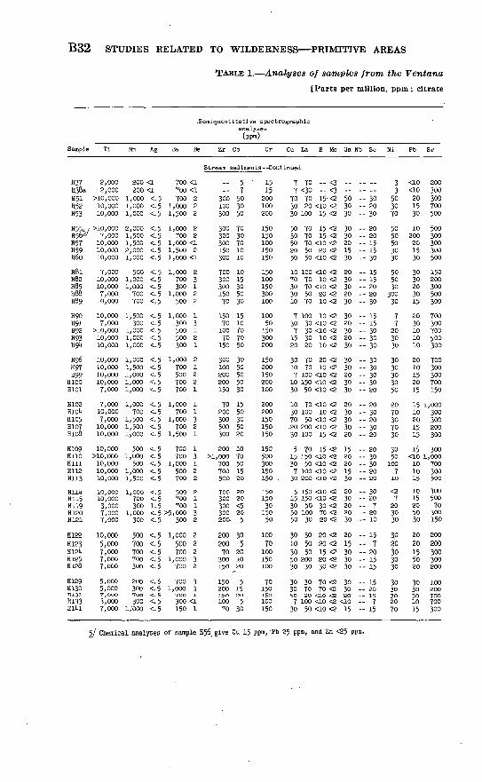
B32 STUDIES RELATED TO WILDERNESS PRIMITIVE AREAS
TABLE 1. Analyses of samples from the Ventana
[Parts per million, ppm; citrate
.Semiquantitatlve spectrographicanalyses(ppm)
Sample Ti Mn Ag Ba Be Zr Co Cr
Stream sediments --Conti
H37 2,000H38a 2,000H51 >10,000H52 10,000H53 10,000
H55,. / >io,oooH562/ 7,000H57 10,000H59 10,000H60 10,000
H8l 7,000H82 10,000H85 10,000H88 7,000H89 10,000
H90 10,000H91 7,000H°2 >10,000H93 10,000Hgi* 10,000
Hg6 10,000H97 10,000H99 10,000
H100 10,000H101 7,000
H102 7,000HlOU 10,000H105 7,000H107 10,000H108 10,000
H109 10,000H110 >10,000Hill 10,000H112 10,000H113 10,000
HllU 1O,OOOH115 10,000H119 3,000H120 7,000H121 7,000
H122 10,000H123 5,000H12U 7,000H125 7,000H128 7,000
H129 5,000H130 5,000H133. 7,000
H133 3,000Hll*l 7,000
200 <1200 <1
1,000 <.1,000 <.1,000 <.
2,000 <.1,500 <.1, 500 <.2,000 <.1,000 <.
500 <.1,000 <.1,000 <.700 <.700 <.
1,500 <.300 <.
1,000 <.1,000 <.1,000 <.
1,000 <.1,500 <.1,000 <.1,000 <-1,000 <.
1,000 <.700 <.
1,500 <.1,500 <.1)000 <.
500 <.1,000 <.
500 <.1,000 <.1,500 <.
1,000 <.700 <.300 1.
1,000 <.300 <.
500 <.700 <.700 <.700 <.300 <.
200 <.300 <.700 -a.300 <.
i;ooo <.
700 <i700 <i
5 700 25 1,000 25 1,500 2
5 1,000 25 700 25 1,000 <i5 1,500 25 1,000 <i
5 1,000 25 700 35 300 15 1,000 25 500 2
5 1,000 i5 300 35 500 15 500 25 300 i
5 1,000 25 700 i5 500 25 700 25 700 i
5 1,000 i5 700 15 1,000 35 700 25 1,500 1
5 700 15 700 35 1,000 i5 500 25 700 2
5 500 25 700 i5 700 15 >5,000 35 300 2
5 1,000 25 500 25 700 25 1,000 35 700 2
5 700 35 1,000 35 700 1
5 300 <15 150 1
--
300100300
300300300150300
70030030015070
1507010070
15030010020020015070
200300500300
200>1,000
700700500
700300300300200-
20020070
300150
15020015010070
57503050
7030701010
1015305030
1510707050
3050505030
1550305020
1070501520
2020<520
5
305
201020
515205
30
' 1515
200100200
150150100150150150100150300100
10050
150300200
150200150200100
200200150150150150500300150150 .1501503015050
10070100150100
70150150100150
Cu La B Mo
nued
7 70 -- <37 <3o <3
70 70 15- <230 20 <10 <230 100 15 <2
50 70 15 <230 70 15 <250 70 <10 <220 50 20 <250 50 <io <2
10 100 <10 <270 70 10 <230 70 <10 <230 50 20 <210 70 10 <2
7 100 10 <230 30 <io <27 30 <10 <2
15 30 10 <220 20 10 <2
30 70 20 <210 70 10 <27 100 <10 <2
10 150 <10 <230 50 <10 <2
10 70 <10 <230 100 10 <270 50 <10 <2.20 200 <10 <230 100 15 <2
5 TO 15 <215 150 <LO <230 50 <io <27 100 <10 <230 2OO <LO <2
5 150 <10 <215 150 <10 <230 50 30 <250 100 70 <250 30 20 <2
30 30 20 <210 50 20 <230 50 15 <250 200 20 <230 30 30 <2
30 30 70 <230 70 70 <2so so <ao <27 100 <10 <2
30 50 <10 <2
Ga :
..--503030
3030201530
2030302030
3020302030
3030203030
2030303020
1520201530
2030202030
2015303030
303020<1015
Nb Sc
-- _--- 30-- 20- 30
-- 20-- 20- 15- 15- 30
- 15- 15 20-- 20-- 30
- 15- 15- 30-- 30- 30
-- 30- 30-- 30-- 30 20
20- 30-- 20-- 30 20
-- 20-- 30-- 30 20-- 20
- 30-- 20-- 7 20-- 10
- 15-- 7 20-- 15-- 15
-- 15-- 20-- 15- 7- 15
Ni
33
503070
5050503030
505030
30030
77203030
3030303050
2070307030
3050
100710
<27
203030
3030303030
3030302070
Pb
<10<10201530
10200201530
3030203015
2030101010
2010152015
1510201515
15<10101015
1015205030
2020155020
3030301015
Sr
200300300700500
500300300300500
150200300500300
700300700500300
700300300700150
1,000300300200300
3001,000
700300500
30050070300150200200300300200
100200TOO700300
5/ Chemical analyses of sample H56, give Cu 15 ppm,-Pb 25 ppm, and Zn <25 ppm.

THE VENTANA PRIMITIVE AREA, MONTEREY COUNTY, CALIF. B33
primitive area, Monterey County, Calif. Continued
soluble heavy metals test, cxHM]
Sample
Semiquantitative analyses
(ppra)
V Y Zn
spectrographic --Continued
(percent)
Fe Mg Ca
Chemical analyses (ppm)
Hg Au cxHM Sample description
Stream sediments--Continued
H37H38aH51H52H53
H55H56H57H59H6o
H8lH82H85H88H89
H90H91H92H93H94
H96H97H99
H100H101
H102H10UH105H107H108
H109H110HillH112H113
HllUH115H119H120H121
H122H123H12kH125H128
H129H130H131H133HIM
5050
15070100
10070
10010070
5070150100100
10030
150100150150100100100100
501001007070
7010015070150
10015030
10050
70707070 70
70705030100
15 <20010 <20020 <20015 <20030 <200
30 <20030 <20015 <20015 <20015 <200
15 <20030 <20030 <20020 <20030 <200
20 <20010 <20020 <20020 <20030 <200
30 <20030 <20030 <20020 <20020 <200
15 <20030 <20030 <20030 <20030 <200
20 <20050 <20020 <20020 <20030 <200
30 <20070 <20015 <20030 <20010 <200
20 <20020 <20020 <20020 <20015 <200
15 <20030 <20015 <2005 <200
20 <200
23
1577
' 10
71077
577.7
7
7771010
77777
510775
710777
710377
53557
55727
11533
33333
23333
31.5555
35353
35533
37333
33121.5
1.51.5323
1.52323
1.51.5532
53375
1-51.5333
72357
551-551.5
33522
107337
35.5
2.7
131.5
. 2.7
.71.53
202
..
o.oto.200.150.020.200.090.220.180
.280
.240
.080
.120
.oto
.litO
.200
.090
.030
.050
.050
.100
.140
.180
.030
<.010.030
' .180.210.090
.290
.lUo
.100
.01*0
.030
.050
.120
.100<.010.070
.iko
.090
.080
.050<.010
.030
.010
.170
.030
.170
<0. 1<. 1.1
<. 1<.l
<. 1.3
<.l<..!<.l
<.l<. 1<.2.2
<.l
<. 1<. 1<. 1<.l<. 1
<.l<. 1<.l<. 1<.l
<. 1<. 1<. 1<.l<.l
<. 1<.l.1
<. 1<.l
.1
.2<.l<.l<. 1
<.l<.l<. l'<. 1<.l
<.l<. 1<. 1<. 1<. 1
1 Stream sediment. 5
233
23352
2.522.5
1
1.5
222
31313
227231
32323
22233
12.512.51
32.5312
Do.Do.Do.Do.
Do.Do.Do.Do.Do.
Do.Do.Do.Do.Do.
Do.Do.Do.Do.Do.
Do.Do.Do.Do.Do.
Do.Do.Do.Do.Do.
Do.Do.Do.Do.Do
Do.Do.Do.Do.Do.
Do.Do.Do.Do.Do.
Do.Do.Do.Do.Do.
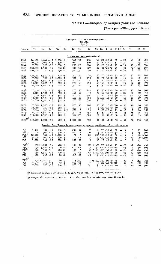
B34 STUDIES RELATED TO WILDERNESS PRIMITIVE AREAS
TABLE 1. Analyses of samples from the Ventana
[Parts per million, ppm; citrate
Semiquantitative spectrographlcanalyses(ppm)
Sample Ti Mn Ag Ba Be Zr Co Cr
Stream sediments --Conti
KiteHl*t3HIMHll»5H1U6
H153H154H155H156H157
H158Hl66Hi69H170H171'
H172H177H178H179Hl8l
1UBS&
P65P66 ,P67^/P68P69
10,00010,0007,000
>10,000>10,000
>10,0007,00010,00010,00010,000
7,0005,0007,00010,00010,000
7,00010,0007,000
10,000>10,000
>10,000
5,0007,00010,0005,0005,000
1,000 <0.1,000 <.
500 <.1,500 <.700 <.
1,500 <.300 <.
1,500 <.2,000 <.1,000 <.
700 <.1,500 <.1,500 <.1,500 <.1,500 <.
1,500 <.300 <.500 <.
1,500 <.1,500 <.
1,000 <.
Samples
300 <.500 <.500 <.200 <.300 <.
P7c£/ 700 >5,000 <.^ "fl/P72 'P73Plk
P76P77
150200150100
3,000 <.700 5
1,500 <.700 <.
150 >5,000 52,000 300 <.7,000 300 <.
5 1,000 15 300 25 1,000 35 200 <15 150 <l
5 700 <l5 1,000 i5 200 15 500 15 200 1
5 150 15 300 25 500 35 300 15 300 i
5 700 15 700 25 700 1.5 700 25 700 2
5 700 2
from Trampa
5 700 25 500 25 1,500 i5 700 35 500 2
5 <10 15 20 <1
<LO <15 <10 <l5 20 <1
30 2 5 70 15 300 3
300 30200 70200 20300 50500 30
300 30300 5200 20200 50300 20
200 50150 15200 70100 30200 70
200 50300 5
5 200 5300 15500 20
1,000 20
Canyon copper
200 <5200 570 7
700 <5 100 <5
loo <5<io <530 710 <5
<io <5
15 150 500 <5500 15
15030010050030
70150701507Q
20070
700 300300
7003030
150300
300
prospect,
7102055
20 1, 55 5,
<5 1,<5
5>5,
30
Cu La B Mo
nued
30 20 <10 <270 50 <10 <230 20 50 <230 30 <10 <220 100 20 <2
70 70 30 <220 70 30 <230 50 20 <250 150 10 <230 30 10 <2
30 30 <10 <230 50 <10 <250 70 15 <230 150 10 <230 70 10 <2
20 70 10 <25 <20 <10 <27 100 <10 <2
30 150 10 <230 50 30 <2
20 50 10 <2
Ga Nb
30 -30 -30 -15 --20 --
30 20 20 --30 -20
20 --20 30 -20 --30 -
30 -10 15 --15 --30 --
30 -
northeast of primitive
10 <20 <10 <27 150 <10 <2
200 150 <10 <270 <20 <10 <210 20 20 <2
500 <20 20 <2300 <20 <10 <2000 <20 50 <2500- <20 300 <230 <20 <10 <2
000 300 20 <2 5 <20 <10 <2
30 30 <10 <2
20 --30 30 -15 --.20
15 --<10 --20 30 -
<10 -
30 -
20
Sc
2030153030
3015203020
2020203030
3010151530
30
area
5:T
11*
77
<5<5<5<5<5
<5
15
Ni
507030
T3030303020
7030
3007070
7077
1570
30
537
<27
<23
<2<2<2
<J10
Ph
2015
- 30'<LO
10
2030201015
2020151010
1010101515
150
1515202015
<1010
<10<1010
<LO3020
Sr
700200300150150
200300150300200
300150200300300
300200150300300
300
700700
1,5001,500
70
<50. 500<50<50500"
100300
6/ Chemical analyses of sample Hl82 give Cu 15 ppm, Pb <25 ppm, and Zn 25 ppm.
7/ Sample P67 contains 1O ppm Bi. All other samples contain less than 10 ppm Bi.

THE VENTANA PRIMITIVE AREA, MONTEREY COUNTY, CALIF. B35
primitive area, Monterey County, Calif. Continued
soluble heavy metals test, cxHM]
Sample
Semiquantitativ analyses
(ppm)
V Y Zn
e spectrographic --Continued
(percent)
Fe Mg Ca
Chemical analyses
(ppm)
Hg Au cxHM Sample description
Stream sediments--Continued
Hll*2Hll»3HI1*!*Hl!*5Hll*6
H153HIS1*H155H156H157
H158H166Hi6gH170H171
H172H177H178H179Hl8l
H182
P65P66P67P68P6g
P70P71P72-P73P7i*
P75P76P77
200100100100200
100705070TO
7030
100100100
1007050
100150
150
3030502030
2010
<10
50 <20015 <20020 <20030 <20020 <200
50 <20015 <20030 <20050 <20020 <200
15 <20050 <20050 <20030 <20030 <200
30 <20010 <20030 <20030 <20030 <200
20 <200
Samples
7 <20015 <20015 <20010 <20015 <200
5 500<5 <2005 200
7 7
71010
771077
10107710
10557
10
10
35353
33232
31.537
51.1.37
5
-5
55
531.71.
1.1.1.1.1.
3125
10
321.37
10
from Trarapa Canyon
33733
202
20<10 5 300 >20<10
203050
<5 <200
20 3005 <200
15 <200
8/ Samples P70 andless than 10 ppm Sn.
.2
151-57
P72 cor
12
1.
3321.
3
7
75
57
l7
itain
1.222
20>20" 7
2>20
1532
0,
5
5
55555
5
.080
.200
.070
.160
.01*0
.220,080.070.050.100
,oi»o,060.200,110,030
,080,230,180,110,080
,030
copper pro
5
<.
7
150 ppm Sn;
,020020,0100!*0,030
010020ft6o050O'tO
oi*ooi*o200
P75
<0. 1<.l.2
<.l<.l
.2<. 1<. 1<. 1<. 1
<. 1<. 1<. 1<.l<.l
<. 1<. 1<. 1<.l<. 1
<.l
spect,
<.l<. 1<.l<.l.2
<.l<.l<. 1<.l.2
.3<. 1<.l
contai
11232
2.51111
21352
14232
-
Stream sediment.Do.Do.Do.Do.
Do.Do.Do.Do.Do.
Do.Do.Do.Do.Do.
Do.Do.Do.Do.Do.
Do.
northeast of primitive area
..--------
..-.--__--
..----
ns 200
Granitic rock.Do.Do.Do.Do.
Same t -rich skarn.Calcite, trace of malachite.Oxidized skarn.Oxidized skarn.Calcite.
Limonitic skarn.Brown carbonate rock.Stream sediment.
ppm Sn. 'All other samples contain

B36
EVALUATION OP METAIXIC MINERALS
Visual examination of rocks and soils failed to reveal the presence of metallic mineral deposits. Faults, shear zones, and fractures were examined carefully but, except for a trace of lead and zinc at one local ity, no mineralization was noted along them. Hydrothermal alteration, a common clue to mineralization, appears to be restricted to thin zones along fractures and faults; no evidence of accompanying metal deposi tion was seen. Many of the rocks, and especially the metamorphic rocks, are weathered to a friable aggregate of mineral grains stained by limonite as a result of the breakdown of iron-bearing silicate and oxide minerals. Many of the samples described as "altered rocks" in table 1 are weathered rocks of this type. Most of the faults are younger than the main igneous episode, and thus they were not present to act as passageways for any ore-forming fluids that may have been asso ciated with the igneous rocks. The only veins observed are quartz veins up to about 1 foot thick that cut Upper Cretaceous sedimentary rocks; no ore minerals were found in these veins.
Locally, the metamorphic rocks, especially the quartz-rich varieties, contain scattered grains of iron sulfide accompanied by graphite, but no ore minerals were seen in these rocks. A rusty gossanlike weathered crust generally distinguishes the sulfidic gneisses. The sulfides are thought to be syngenetic, that is, they represent original sulfurous sedimentary beds, most of which were carbonaceous as well. Black shales typically have these characteristics and upon metamorphism could yield gneisses containing graphite and sulfide minerals.
The calc-silicate gneisses resemble tactites in mineralogy, but unlike tactites have no close spatial relation to igneous contacts, and they seem to be of regional metamorphic origin. The calc-silicate gneisses contain sporadically distributed sulfide minerals that probably are recrystallization products of the original sedimentary rocks, but small amounts of copper in some samples suggest the possibility of minor epigenitic mineralization, as in the following discussion.
The lack of visual indications of ore deposits is corroborated by the analytical data for 515 samples shown in table 1. The analytical results indicate that with a few exceptions, most of the samples contain only normal metal content and none of them contain metal in quantities approaching ore grade.
Analyses of fresh rocks show a wide range in the content of some metals, the quantity depending to a large degree on the rock types.Some of the intrusive and metamorphic rocks, and the hornblende- rich rocks in particular, contain as much as 200 ppm (parts per mil-lion) copper, and ultramafic intrusive rocks contain up to several tenths of a percent nickel and chromium. Such concentrations how-

THE VENTANA PRIMITIVE AREA, MONTEREY COUNTY, CALIF. B37
ever, are not unusual for rocks of this type. It is unlikely that they are indicative of economically important concentrations. Comparable concentrations of copper, nickel, and chromium have been reported in amphibolite from Montana by Becraft and others (1966, p. B16, B17).
Gold and mercury analyses of all samples indicate no unusual or economically interesting concentrations of these elements.
Although the analyses of most samples listed in table 1 as "Altered rocks" obviously reflect the composition of the parent rock, a few may have been slightly enriched in metals, especially copper, lead, or zinc. Sample P16a is a sulfide-bearing calc-silicate rock from North Fork Little Sur Eiver that was determined spectrographically to contain 1,500 ppm copper. Similar rock was resampled from the same local ity, but the second sample contained only 10 ppm copper, which is indicative of the sporadic copper distribution. No copper minerals were visible at the site. Sample P88 contains 300 ppm copper and microscopically visible chalcopyrite. This sample was collected from a small boulder of amphibolite from Logwood Creek; its source is not known as only the one boulder could be found. Several other samples (P198b, H35, H134, H175) of sulfide-bearing amphibolite and other iron-rich metamorphic rocks were collected that give somewhat higher than average values for copper or zinc.
A sample of brecciated pegmatite from a fault in the "Coast Ridge fault zone" of Eeiche (1937, p. 152) contained 1,500 ppm zinc and 3,000 ppm lead, the highest concentrations of lead and zinc found in the area. The zinc silicate calamine was identified in the sample but no lead mineral could be found. Neither the sample nor the other rocks in the vicinity show any obvious mineralization. The metals may be in the small amount of gouge along the fault, or they could have been in primary accessory minerals of the pegmatite. Sediment sam ples from streams that drain across this fault and other nearby faults are not unusually high in metals (see samples H123, H124, H125, H128, H129,P178andP179).
The stream-sediment samples in general contain only small quan tities of metals. Most of them contain 10 to 70 ppm copper and lead and less than 200 ppm zinc, the lower limit of detection by spectro- graphic analysis. Three samples, however, gave anomalously high spectrographic values: P259a, 500 ppm copper; H56, 200 ppm lead; and H182, 150 ppm lead. By colorimetric analysis, the three samples gave much lower results, in parts per million: P259a copper 15, lead <25, zinc 38; H56 copper 15, lead 25, zinc <25; H182 copper 15, lead <25, zinc 25.

B38 STUDIES RELATED TO WILDERNESS PRIMITIVE AREAS
The citrate soluble heavy metals test (cxHM in table 1) was per formed on stream sediments to determine the quantity of weakly held metals (copper, lead, and zinc) that have been deposited on the mineral grains from stream water. It is one means of tracing these metals to a source upstream. The results of the heavy metals test (table 1) on 186 stream-sediment samples contain four values greater than 7 ppm. By comparison with the other samples, these four appear to be anomalously high. The localities were revisited and resampled. Sample PllOd (32 ppm cxHM) comes from a west tributary of Lion Creek, which flows approximately on the trace of the Redwood fault. This is the same general area of the mining claims near Island Moun tain. Presumably the area was prospected when these claims were staked, but no discoveries are known. Three float pebbles of altered rock (PllOa, PllOb, PllOc) were collected at the same locality, but spectrographic analyses did not disclose anomalous metal values in them. No evidence of mineralization along the Redwood fault was noted by us or by Fiedler (1944).
A resampling of the Lion Creek tributary failed to produce stream- sediment samples containing high cxHM values (samples P276a, P277b, P278, P289a, P289b, and P291). Bedrock samples (P275, P276b, and P277a) of sulfide-bearing gneiss collected along the stream did, however, suggest that the gneiss was the source of the metal in the original stream sample. The sulfide-bearing gneiss occurs in numerous layers and lenses along the stream. Spectrographic analyses show that it is slightly high in zinc and copper, and notably high in molybdenum and vanadium.
An anomalous sample (H104) containing 27 ppm cxHM was col lected from the mouth of an intermittant stream draining into the Carmel River off the east side of Elephant Mountain, but a resampling of the stream sediments failed to duplicate the initial high cxHM value. As in the Lion Creek area, sulfide-bearing gneisses are present along the lower half mile of the stream. Spectrographic analyses of the gneisses (samples P268 and P273) show slightly high copper con tents of 70 and 100 ppm, and an iron-rich spring deposit (sample P267a) contains 500 ppm zinc.
Stream-sediment samples P108 from South Fork Little Sur River and P118a from Doolans Hole Creek containing 9 and 11 ppm cxHM, respectively, are slightly higher than normal. These samples were collected on nearly opposite sides of the divide at the head of Doolans Hole Creek. An altered float pebble (P118b) from Doolans Hole Creek did not contain anomalously high quantities of copper, lead, or zinc. Two samples (PlOla and PlOlb) of altered rock from the drainagedivide likewise show only average amounts of metals in the spectro-
THE VENTANA PRIMITIVE AREA, MONTEREY COUNTY, CALIF. B39
graphic analyses. Additional stream-sediment samples from these areas contain average cxHM values. Although no rocks were found in the drainage area represented by these samples that may have contrib uted to the cxHM values of samples P108 and PllSa, it is likely that sulfide-bearing gneisses are present and are the source.
The metal content of some of the sulfide- and graphite-bearing gneisses is comparable to many unmetamorphosed carbonaceous sedi mentary rocks (Davidson and Lakin, 1961,1962; Vine, 1966), and the gross chemistry of the gneisses suggests that they were derived from such sedimentary rocks. Davidson and Lakin (1961) concluded that because of their metal concentrations, some black shales will become ores in the future. Similarly, it is possible that the metalliferous gneisses of the Ventana primitive area might one day be ore, but their grade, in the hundredths of a percent, is presently below ore grade.
LIMESTONE (MARBLE)
Discontinuous layers and pods of recrystallized limestone are wide spread in the metamorphic rocks in the primitive area. The layers and pods are small, very difficult to reach, and of variable quality, and there is little likelihood that they could be exploited economically in the foreseeable future. Much larger bodies occur in the same geologic environment 1 to 3 miles west and southwest of the primitive area. These bodies, which have been quarried on a very small scale in the past, are nearer California Highway 1 and hence are more easily accessible and could be mined more cheaply than those in the area.
The largest limestone bodies in the primitive area lie on or near the southwest boundary, in particular on the ridge known as Cabezo Prieto north of Big Sur River. A few others of comparable size are known in the vicinity of Eedwood Creek and Lost Valley Creek. The largest bodies found are shown on plate 1; numerous smaller bodies scattered widely through the metamorphic rock are not shown. The many bodies west and southwest of the primitive area that are shown on plate 1 are taken from maps by Trask (1926) and Reiche (1937). Although bedrock outcrop is poor in some parts of the area, it is doubtful that marble bodies larger than those shown on plate 1 are present.
The composition of the marble ranges widely as indicated by the partial analyses in table 2. In general the purer marbles were sampled. Some of the analyzed samples are single specimens chosen to represent a body or part of a body, and others are composite samples collected by taking a chip every 2 to 3 feet across the outcrop. The analyses show that several of the marbles are high in CaO and that if the marble deposits were present in larger quantities they would be satisfactory

B40 STUDIES RELATED TO WILDERNESS PRIMITIVE AREAS
for most uses. The "remainder" in the analyses consists mostly of SiO2 ; 1 percent or less of crystalline graphite is present in most samples.
TABLE 2. Partial analyses of marble samples
[Sample type: S, selected specimen; C, chip sample. Results in percent. Total iron as Fe203. Remainder, probably mostly SiOj not analyzed. PjOs determined by volumetric method by G. D. Shipley; CaO, MgO, and FejOs, determined by atomic absorbtion method by W. D. Goss; AhOs determined by colori- metric method by W. D. Goss; COs determined by gasometric method by D. L. Kouba]
Sample
P107. .............P119..P120. .............P236__ ............P241. .............
P245a. ............P245b.. .......... .P245c. .... ........P252. .............P254. .............
P264.. ............P265__ ............P266-. ............H42b... ...........H48b..............
H160-. .... .......H164.... ..........H165..............H167.... ..........
Sample type
SSSSS
SSSCC
CCCCC
SCSC
P205
0.06.12.09.05.03
.10
.12
.16
.19
.15
.15
.10
.10
.11
.10
.06
.06
.04
.10
CaO
55.255.354.030.754.4
54.654.456.446.442.4
50.253.852.750.249.3
49.815.042.633.7
MgO
0.48.36.26
2.08.39
1.04.58.41.58
2.02
3.28.38
1.801.761.14
.581.00.80
3.20
FeaOs
0.14.11.12
2.72.22
.16
.15
.153.524.64
.11
.14
.263.523.68
2.723.522.403.52
AbOs
0.55.97
1.291.84.69
.78
.601.202.214.6
.97
.60
.692.072.76
3.2210.63.504.83
C0 2
42.542.443.020.342.0
43.443.342.936.229.9
41.742.842.139.236.1
39.38.68
31.17.72
Re mainder
1.07.74
1.2442.312.27
.85
10.916.29
3.592.182.353.146.92
4.3261.1419.5646.93
One of the larger and most accessible of the high-calcium marble bodies forms the top of Marble Peak. Though not completely exposed, it is probably about 1,000 feet long, less than 500 feet wide, and 150 feet thick at its thickest part. Marble Peak is on a poor road about 12 miles from California Highway 1 and about 45 miles from the nearest railhead at Monterey. A few other bodies, such as the one in Doolans Hole Creek, are similar in size but are more remote and in very rugged terrain.
OIL AND GAS
It is very unlikely that commercial quantities of oil and gas underlie the primitive area. The possibilities are virtually nonexistent wherever pre-Cretaceous crystalline rocks crop out at the surface as they do in a major pact of the primitive area, The narrow and isolated bands ofsedimintary rock preserved along the Church Creek and Palo Colorado faults also offer virtually no possibility of oil or gas traps. An areaof a few square miles south of Lost Valley is underlain by Cretaceousand younger rocks and cannot be dismissed as readily but, neverthe less, offers little promise. Here, there are rocks that could conceivably act as oil and gas reservoir rocks but they are in a very unfavorable structural and topographic position. Several oil fields are presentalong the Salinas River valley about 20 to 30 miles east and southeastof the primitive area. Wells in these fields apparently all produce

THE VENTANA PRIMITIVE AREA, MONTEREY COUNTY, CALIF. B41
from rocks of middle and late Miocene age. Only older rocks are known in the primitive area.
ECONOMIC APPRAISAL
By PAUL V. FILLO, U.S. Bureau of Mines
Investigations of mineral occurrence and economic potential in the Ventana primitive area by the U.S. Bureau of Mines consisted of searching the mineral claim location and assessment records in the Monterey County recorder's office and the mineral production records in the Federal files. In addition, a helicopter, under contract to the U.S. Geological Survey, was used to make an air reconnaissance of the area and to drop and pick up field personnel, who conducted examinations on the ground. These on-site inspections of potential mineralized areas were made jointly by Robert C. Pearson, U.S. Geo logical Survey, and Paul V. Fillo, U.S. Bureau of Mines. The U.S. Forest Service provided information on claims filed before 1938 in and near the primitive area.
MINING CLAIMS
The Monterey County records disclosed two* lode claims in the Ventana primitive area in sec. 23, T. 19 S., R. 2 E., and 18 placer claims, all in T. 19 S., R 2 E., Mount Diablo base and meridian. These lode and placer claims were located in the fall of 1931. The descriptions of these claims, given in the location notices, were vague and the work ings could not be recognized because of dense vegetation covering the area.
No record of mineral production from the Ventana primitive area was found in the Federal files. No current assessment work was re corded in the county records and no Federal oil and gas leasing activ ity had been established in the primitive area.
CONCLUSIONS
Investigation of the Ventana primitive area by the Bureau of Mines did not disclose any exploitable mineral occurrences, and none were found as a result of the Geological Survey field examination.

B42 STUDIES RELATED TO WILDERNESS PRIMITIVE AREAS
REFERENCES CITED
Becraft, G. E., Calkins, J. A., Pattee, E. C., Weldin, R. D., Roche, J. M., 1966, Mineral Resources of the Spanish Peaks Primitive Area, Montana: U.S. Geol. Survey Bull. 1230-B, 45 p.
Compton, R. R., 1957, New Paleocene formation in the central 'Coast Ranges, California [abs.] : Geol. Soc. America Bull., v. 68, no. 12, pt. 2, p. 1820-1821.
Compton, R. R., 1960a, Charnockitic rocks of .Santa Lucia Range, California: Am. Jour. Sci., v. 258, no. 9, p. 609-636.
Compton, R. R., 19601), Relations of major folds and reverse faults in Santa Lucia Range, California [afcs.] : Geol. Soc. America Bull., v. 71, no. 12, pt. 2, p. 2054.
Compton, R. R., 1966, Analyses of Pliocene-Pleistocene deformation and stresses in northern 'Santa Lucia Range, California: Geol. Soc. America Bull., v. 77, no. 12, p. 1361-1380.
Davidson, D. F., and Lakin, H. W., 1961, Metal content of some iblack shales of the western United 'States, in Short papers in the geologic and hydrologic sciences: U.S. Geol. Prof. Paper 424-O, p. C329-C331.
, 1962, Metal content of some black shales of the western conterminous United States Part 2, in Snort papers in geology and hydrology: U.S. Geol. Survey Prof. Paper 450-C, p. C74.
Dickinson, W. R., 1965, Tertiary stratigraphy of the Church Creek area, Monterey County, California, in Short contributions to California geology: California Div. Mines Spec. Rept. 86, p. 25-44.
Durham, D. L., 1965, Evidence of large strike-slip displacement along a fault in the southern 'Salinas Valley, California: U.S. Geol. Survey Prof. Paper 525-D, p. D106-D111.
Fiedler, W. M., 1944, Geology of the Jamesburg quadrangle, Monterey County, California: California Jour. Mines and Geology, v. 40, no. 2, p. 177-250.
Jenkins, O. P., 1950, Annual report of the State Mineralogist, Chief of the Divi sion of Mines, for the 100th fiscal year, July 1, 1948 to June 30, 1949: Cali fornia Jour. Mines and Geology, v. 46, no. 1, p. 143-184.
Hill, M. L,., and Dibble, T. W., Jr., 1953, San Andreas, Garlock, and Big Pine faults, California a study of the character, 'history, and tectonic signifi cance of their displacements : Geol. 'Soc. America Bull., v. 64, no. 4, p. 443^158.
Reiche, Parry, 1937, Geology of the Lucia quadrangle, California: California Univ. Dept. Geol. Sci. Bull., v. 24, no. 7, p. 115-168.
Trask, P. D., 1926, Geology of the Point Sur quadrangle, California: California Univ. Dept. Geol. Sci. Bull., v. 16, no. 6, p. 119-186.
Vine, James D., 1966, Element distribution in some shelf and eugeosynclinal blackshales: U.S. Geol. Survey Bull. 1214-E, 31 p.
Wannnnen, -A~ o., nnd Bean, it. T., 19O6, water resource appraisal, in Mineraland water resources of California, Part 2 of report of U:S. Geological Survey prepared in collaboration with the California Department of Water Re sources: U.S. 89th Gong., 2d sess., Senate Comm. on Interior and Insular Affairs, p. 451-513.
O