Embed Size (px)
Citation preview
Mineral Resources of theSpring Basin Wilderness Study Area,Wheeler County, Oregon
U.S. GEOLOGICAL SURVEY BULLETIN 1 743-C
AVAILABILITY OF BOOKS AND MAPS OF THE U.S. GEOLOGICAL SURVEY
Instructions on ordering publications of the U.S. Geological Survey, along with prices of the last offerings, are given in the cur rent-year issues of the monthly catalog "New Publications of the U.S. Geological Survey." Prices of available U.S. Geological Sur vey publications released prior to the current year are listed in the most recent annual "Price and Availability List." Publications that are listed in various U.S. Geological Survey catalogs (see back inside cover) but not listed in the most recent annual "Price and Availability List" are no longer available.
Prices of reports released to the open files are given in the listing "U.S. Geological Survey Open-File Reports," updated month ly, which is for sale in microfiche from the U.S. Geological Survey, Books and Open-File Reports Section, Federal Center, Box 25425, Denver, CO 80225. Reports released through the NTIS may be obtained by writing to the National Technical Information Service, U.S. Department of Commerce, Springfield, VA 22161; please include NTIS report number with inquiry.
Order U.S. Geological Survey publications by mail or over the counter from the offices given below.
BY MAIL
Books
Professional Papers, Bulletins, Water-Supply Papers, Techniques of Water-Resources Investigations, Circulars, publications of general in terest (such as leaflets, pamphlets, booklets), single copies of Earthquakes & Volcanoes, Preliminary Determination of Epicenters, and some mis cellaneous reports, including some of the foregoing series that have gone out of print at the Superintendent of Documents, are obtainable by mail from
U.S. Geological Survey, Books and Open-File ReportsFederal Center, Box 25425
Denver, CO 80225
Subscriptions to periodicals (Earthquakes & Volcanoes and Preliminary Determination of Epicenters) can be obtained ONLY from the
Superintendent of DocumentsGovernment Printing Office
Washington, D.C. 20402
(Check or money order must be payable to Superintendent of Docu ments.)
Maps
For maps, address mail orders to
U.S. Geological Survey, Map DistributionFederal Center, Box 25286
Denver, CO 80225
Residents of Alaska may order maps from
Alaska Distribution Section, U.S. Geological Survey,New Federal Building - Box 12
101 Twelfth Ave., Fairbanks, AK 99701
OVER THE COUNTER
Books
Books of the U.S. Geological Survey are available over the counter at the following Geological Survey Public Inquiries Offices, all of which are authorized agents of the Superintendent of Documents:
WASHINGTON, D.C.-Main Interior Bldg., 2600 corridor,18th and CSts.,NW.DENVER, Colorado-Federal Bldg., Rm. 169, 1961 Stout St.LOS ANGELES, California-Federal Bldg., Rm. 7638,300 N.Los Angeles St.MENLO PARK, California-Bldg. 3 (Stop 533), Rm. 3128,345 Middlefield Rd.RESTON, Virginia-503 National Center, Rm. 1C402,12201Sunrise Valley Dr.SALT LAKE CITY, Utah-Federal Bldg., Rm. 8105, 125South State St.SAN FRANCISCO, California-Customhouse, Rm. 504,555Battery St.SPOKANE, Washington-U.S. Courthouse, Rm. 678, West920 Riverside Ave..ANCHORAGE, Alaska-Rm. 101,4230 University Dr.ANCHORAGE, Alaska-Federal Bldg, Rm. E-146, 701 C St.
Maps
Maps may be purchased over the counter at the U.S. Geologi cal Survey offices where books are sold (all addresses in above list) and at the following Geological Survey offices:
ROLLA, Missouri-1400 Independence Rd. DENVER, Colorado-Map Distribution, Bldg. 810, Federal
Center FAIRBANKS, Alaska-New Federal Bldg., 101 Twelfth Ave.
Chapter C
Mineral Resources of theSpring Basin Wilderness Study Area,Wheeler County, Oregon
By JAY A. ACH, SCOTT A. MINOR, JAMES G. FRISKEN, and RICHARD J. BLAKELY U.S. Geological Survey
RICHARD A. WINTERS and THOMAS J. PETERS U.S. Bureau of Mines
U.S. GEOLOGICAL SURVEY BULLETIN 1 743
MINERAL RESOURCES OF WILDERNESS STUDY AREAS: JOHN DAY REGION, OREGON
DEPARTMENT OF THE INTERIOR
DONALD PAUL MODEL, Secretary
U.S. GEOLOGICAL SURVEY
Dallas L. Peck, Director
Any use of trade names and trademarks in this publication is for descriptive purposes only and does not constitute endorsement by the U.S. Geological Survey
UNITED STATES GOVERNMENT PRINTING OFFICE, WASHINGTON : 1989
For sale by theBooks and Open-File Reports SectionU.S. Geological SurveyFederal Center, Box 25425Denver, CO 80225
Mineral resources of the Spring Basin Wilderness Study Area, Wheeler County, Oregon.
(U.S. Geological Survey bulletin ; 1743-CBibliography: p.Supt. of Docs. no. : I 19.3:1743-C1. Mines and mineral resources Oregon Spring Basin
Wilderness. 2. Geology Oregon Spring Basin Wilderness. 3. Spring Basin Wilderness (Or.) I. Ach, Jay A. II. Series. QE75.B9 no. 1743-C 557.3s 88-600388 [TN24.07] [553'.09795'81]
STUDIES RELATED TO WILDERNESS
Bureau of Land Management Wilderness Study Areas
The Federal Land Policy and Management Act (Public Law 94-579, October 21, 1976) requires the U.S. Geological Survey and the U.S. Bureau of Mines to conduct mineral surveys of certain areas to determine the mineral values, if any, that may be present. Results must be made available to the public and be submitted to the President and the Congress. This report presents the results of a mineral survey of part of the Spring Basin (OR-005-009) Wilderness Study Area, Wheeler County, Oregon.

CONTENTSSummary Cl
Abstract Cl Character and setting Cl Identified resources Cl Mineral resource potential Cl
Introduction C2Area description C2 Previous and present investigations C2 Acknowledgments C3
Appraisal of identified resources C3 Assessment of mineral resource potential C3
Geology C3 Geochemical studies C5 Geophysical studies C6
Magnetic data C7 Gravity studies C7 Radiometric data C7 Conclusions C8
Mineral and energy resource potential of the Spring Basin Wilderness Study Area C8 Mineral resource potential C8 Energy resource potential C9
References cited CIO Appendixes
Definition of levels of mineral resource potential and certainty of assessment C14 Resource/reserve classification CIS Geologic time chart C16
FIGURES
1 Index map showing location of the Spring Basin Wilderness Study Area, Wheeler County, Oregon C2
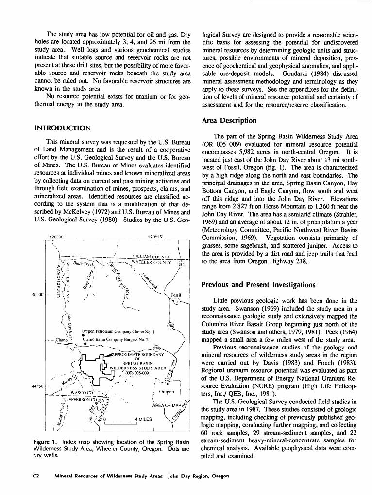
2 Map showing mineral resource potential and geology of the Spring Basin Wilderness Study Area, Wheeler County, Oregon C4
Contents

Mineral Resources of theSpring Basin Wilderness Study Area,Wheeler County, Oregon
By Jay A. Ach, Scott A. Minor, James G. Frisken, and Richard J. Blakely U.S. Geological Survey
Richard A. Winters and Thomas J. Peters U.S. Bureau of Mines
SUMMARY
Abstract
At the request of the U.S. Bureau of Land Management, approximately 5,982 acres of the Spring Basin (OR-005-009) Wilderness Study Area in north-central Oregon were evalu ated for mineral resources (known) and mineral resource potential (undiscovered). In this report, "wilderness study area" and "study area" refer to the 5,982 acres for which mineral surveys were requested. Fieldwork for this report was carried out in 1987. No identified mineral resources are known to exist within the study area. No mines or mining districts are located inside the study area; however, a part of the area is under lease for oil and gas exploration.
An area in the easternmost part of the study area has low mineral resource potential for silver, gold, and mercury. A small area in the central part of the study area has low mineral resource potential for mercury. The study area has a low resource potential for oil and gas and no resource poten tial for uranium or for geothermal energy.
Character and Setting
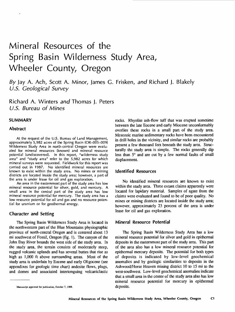
The Spring Basin Wilderness Study Area is located in the northwestern part of the Blue Mountains physiographic province of north-central Oregon and is centered about 13 mi southwest of Fossil, Oregon (fig. 1). The canyon of the John Day River bounds the west side of the study area. In the study area, the terrain consists of moderately steep, rugged volcanic uplands and has several buttes that rise as high as 1,000 ft above surrounding areas. Most of the study area is underlain by Eocene and early Oligocene (see appendixes for geologic time chart) andesite flows, plugs, and domes and associated intertonguing volcaniclastic
Manuscript approved for publication, October 7, 1988.
rocks. Rhyolite ash-flow tuff that was erupted sometime between the late Eocene and early Miocene unconformably overlies these rocks in a small part of the study area. Mesozoic marine sedimentary rocks have been encountered in drill holes in the vicinity, and similar rocks are probably present a few thousand feet beneath the study area. Struc turally the study area is simple. The rocks generally dip less than 5° and are cut by a few normal faults of small displacement.
Identified Resources
No identified mineral resources are known to exist within the study area. Three extant claims apparently were located for lapidary material. Samples of agate from the claims were evaluated and found to be of poor quality. No mines or mining districts are located inside the study area; however, approximately 23 percent of the area is under lease for oil and gas exploration.
Mineral Resource Potential
The Spring Basin Wilderness Study Area has a low mineral resource potential for silver and gold in epithermal deposits in the easternmost part of the study area. This part of the area also has a low mineral resource potential for epithermal mercury deposits. The potential for both types of deposits is indicated by low-level geochemical anomalies and by geologic similarities to deposits in the Ash wood/Horse Heaven mining district 10 to 15 mi to the west-southwest. Low-level geochemical anomalies indicate that a small area in the center of the study area also has low mineral resource potential for mercury in epithermal deposits.
Mineral Resources of the Spring Basin Wilderness Study Area, Wheeler County, Oregon C1
The study area has low potential for oil and gas. Dry holes are located approximately 3, 4, and 26 mi from the study area. Well logs and various geochemical studies indicate that suitable source and reservoir rocks are not present at these drill sites, but the possibility of more favor able source and reservoir rocks beneath the study area cannot be ruled out. No favorable reservoir structures are known in the study area.
No resource potential exists for uranium or for geo- thermal energy in the study area.
INTRODUCTION
This mineral survey was requested by the U.S. Bureau of Land Management and is the result of a cooperative effort by the U.S. Geological Survey and the U.S. Bureau of Mines. The U.S. Bureau of Mines evaluates identified resources at individual mines and known mineralized areas by collecting data on current and past mining activities and through field examination of mines, prospects, claims, and mineralized areas. Identified resources are classified ac cording to the system that is a modification of that de scribed by McKelvey (1972) and U.S. Bureau of Mines and U.S. Geological Survey (1980). Studies by the U.S. Geo-
120°30' 120° 15'
45°00'
44°50'
- r . _. _ _:_ __ _ _GILUAM_coyNTY__ ~"~~^ ~ WHEELER COUNTY
» Oregon Petroleum Company Clamo No. 1
Clarno Basin Company Burgess No. 2
APPROXIMATE BOUNDARYOF
SPRING BASIN WILDERNESS STUDY AREA
WASCqcpJEFFERSON CO
AREA OF MAP.?A
Figure 1. Index map showing location of the Spring Basin Wilderness Study Area, Wheeler County, Oregon. Dots are dry wells.
logical Survey are designed to provide a reasonable scien tific basis for assessing the potential for undiscovered mineral resources by determining geologic units and struc tures, possible environments of mineral deposition, pres ence of geochemical and geophysical anomalies, and appli cable ore-deposit models. Goudarzi (1984) discussed mineral assessment methodology and terminology as they apply to these surveys. See the appendixes for the defini tion of levels of mineral resource potential and certainty of assessment and for the resource/reserve classification.
Area Description
The part of the Spring Basin Wilderness Study Area (OR-005-009) evaluated for mineral resource potential encompasses 5,982 acres in north-central Oregon. It is located just east of the John Day River about 13 mi south west of Fossil, Oregon (fig. 1). The area is characterized by a high ridge along the north and east boundaries. The principal drainages in the area, Spring Basin Canyon, Hay Bottom Canyon, and Eagle Canyon, flow south and west off this ridge and into the John Day River. Elevations range from 2,827 ft on Horse Mountain to 1,360 ft near the John Day River. The area has a semiarid climate (Strahler, 1969) and an average of about 12 in. of precipitation a year (Meteorology Committee, Pacific Northwest River Basins Commission, 1969). Vegetation consists primarily of grasses, some sagebrush, and scattered juniper. Access to the area is provided by a dirt road and jeep trails that lead to the area from Oregon Highway 218.
Previous and Present Investigations
Little previous geologic work has been done in the study area. Swanson (1969) included the study area in a reconnaissance geologic study and extensively mapped the Columbia River Basalt Group beginning just north of the study area (Swanson and others, 1979,1981). Peck (1964) mapped a small area a few miles west of the study area.
Previous reconnaissance studies of the geology and mineral resources of wilderness study areas in the region were carried out by Davis (1983) and Fouch (1983). Regional uranium resource potential was evaluated as part of the U.S. Department of Energy National Uranium Re source Evaluation (NURE) program (High Life Helicop ters, Inc./ QEB, Inc., 1981).
The U.S. Geological Survey conducted field studies in the study area in 1987. These studies consisted of geologic mapping, including checking of previously published geo logic mapping, conducting further mapping, and collecting 60 rock samples, 29 stream-sediment samples, and 22 stream-sediment heavy-mineral-concentrate samples for chemical analysis. Available geophysical data were com piled and examined.
C2 Mineral Resources of Wilderness Study Areas: John Day Region, Oregon
The U.S. Bureau of Mines conducted a library search for information on the geology, mines, and prospects within the study area. Additional data were obtained from Wheeler County and U.S. Bureau of Land Management mining, lease, claim, and land status records. These data were used to determine the geologic setting, mining history, possible mineral commodities, mining claim ownership, and claim localities. Field studies by U.S. Bureau of Mines personnel were carried out in 1987 (Winters and Peters, 1988) and involved searches for any existing mines, pros pects, claims, or mineralized geologic structures; 8 rock samples and 13 alluvial samples were collected. Rock samples were checked for radioactivity and fluorescence. The rock samples also were analyzed for 34 elements by instrumental neutron activation by a contract laboratory. Alluvial samples were concentrated and inspected for gold and other valuable minerals. Complete analytical data are on file at the U.S. Bureau of Mines, Western Field Opera tions Center, E. 360 Third Ave., Spokane, WA 99202.
Acknowledgments
The authors gratefully acknowledge the cooperation of the U.S. Bureau of Land Management personnel of the Prineville District Office, Prineville, Oregon, in providing access information and maps of the study area. Ranchers Jon Bowerman and Bill Cross graciously provided access to their land. Dan E. Wermiel, Oregon Department of Geology and Mineral Industries, provided much informa tion pertaining to the petroleum potential of central Oregon.
APPRAISAL OF IDENTIFIED RESOURCES
By Richard A. Winters and Thomas J. Peters U.S. Bureau of Mines
No mining districts exist in or near the Spring Basin Wilderness Study Area. Three lode mining claims in the study area (fig. 2) apparently were located for lapidary material. The Crystal Peak and MEM-CAF mining claims were located in 1978 and 1975, respectively. The name and date of location of a third claim is unknown. Approxi mately 23 percent of the area studied is currently covered by oil and gas lease applications.
No identified mineral resources exist within the study area. Samples of agate were evaluated and determined to be of poor quality. Four of thirteen alluvial samples con tain gold ranging from 0.0000097 to 0.000416 troy ounces per cubic yard ($0.005 to $0.21 per cubic yard assuming gold at $500 per troy ounce); significant accumulations of alluvium have not been deposited in the study area.
No economic concentrations of minerals were ob served in the rock or alluvial samples, and concentrations of elements detected in rock samples do not differ from
expected crustal abundances. The basalt, andesite, and dacite that underlie the area studied could be used for construction blocks and rubble. However, these low-unit- value, high-bulk commodities are available throughout Oregon in areas of better access (Barton, 1968, p. 62).
ASSESSMENT OF MINERAL RESOURCE POTENTIAL
By Jay A. Ach, Scott A. Minor, James C. Frisken, and Richard J. Blakely U.S. Geological Survey
Geology
The Spring Basin Wilderness Study Area is located in the northwestern part of the Blue Mountains physiographic province, about 10 mi south of the adjoining Columbia Plateau. In the vicinity of the study area, the Blue Moun tains province is characterized by complexly interbedded and interfingering Tertiary volcanic rocks that unconforma- bly overlie pre-Tertiary sedimentary and metasedimentary basement rocks (Swanson, 1969). The rocks in the region are broadly folded and uplifted along northeast trends and are only locally faulted. The Columbia Plateau, just to the north of the study area, is formed by extensive sequences of gently north-tilted Miocene basalt flows of the Columbia River Basalt Group (Swanson and others, 1981; Walker, 1977).
The oldest rocks exposed in the study area (fig. 2) form part of the Eocene and lowermost Oligocene(?) age Clarno Formation (Walker and Robinson, in press), which was originally named and described by Merriam (190la, b). The Clarno Formation crops out in nearly the entire study area, where it has a maximum exposed thickness of about 1,700 ft. However, drill hole data from nearby localities suggest that the Clarno is at least 3,000 ft thick within the study area. The same holes indicate that Mesozoic marine sedimentary rocks occur beneath the Clarno Formation. Within the study area, the Clarno is divided into two inter- tonguing subunits, lava flows (including plugs and domes) and volcaniclastic rocks.
The lava flows, plugs, and domes range in composition from basalt to dacite, although most appear to be andesite. They commonly display columnar cooling joints and typi cally form cliffs. Phenocrysts mainly consist of plagio- clase, pyroxene, and locally hornblende. Many of the plugs and domes are shallow intrusions that both cut and are overlain by surrounding Clarno rocks. Most of the more resistant rocky buttes and hills in and near the study area, such as Sheep Mountain and Black Rock, are probably intrusive plugs (Taylor, 1960) of the Clarno. Locally the lava flows include layers and lenses of breccia (including flow breccia) and volcaniclastic and tuffaceous sedimentary
Mineral Resources of the Spring Basin Wilderness Study Area, Wheeler County, Oregon C3
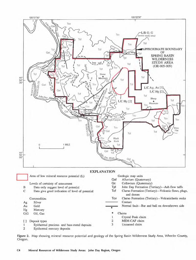
120°2730" 120°2230"
APPROXIMATE BOUNDARYOF
SPRING BASIN WILDERNESS STUDY AREA (OR-005-009)
L/CAg,Au[R L/C Hg [2]A
EXPLANATIONArea of low mineral resource potential (L)
Ag Au Hg 0,G
12
Figure 2.Oregon.
Levels of certainty of assessment Data only suggest level of potential Data give good indication of level of potential
Commodities Silver Gold Mercury Oil, Gas
Deposit typesEpithermal precious- and base-metal deposits Epithermal mercury deposits
Qc Tjd Tcf
Tcv
Geologic map units Qal Alluvium (Quaternary)
Colluvium (Quaternary)John Day Formation (Tertiary) Ash-flow tuffs Clarno Formation (Tertiary) Volcanic flows, plugs,
and domesClarno Formation (Tertiary) Volcaniclastic rocks Contact Normal fault Bar and ball on downthrown side
Claims1 Crystal Peak claim2 MEM-CAF claim3 Unnamed claim
Map showing mineral resource potential and geology of the Spring Basin Wilderness Study Area, Wheeler County,
C4 Mineral Resources of Wilderness Study Areas: John Day Region, Oregon
rocks. Most of the clasts in these rocks are lithologically identical to the enclosing flows, plugs, and domes.
The volcaniclastic facies of the Clarno Formation consist chiefly of andesite mudflow breccia, pyroclastic deposits, and minor tuff. A few andesite lavas are interbed- ded with these rocks. Poorly sorted sedimentary rocks composed of clasts of the various volcanic rocks are ex posed locally, and at one locality a 150-ft-thick, well-bed ded fluvial sequence is exposed. Clasts in this sequence reach diameters of several feet and consist almost entirely of locally derived basalt, andesite, and dacite. The clasts are enclosed in tuffaceous or silt- and clay-rich matrices. The volcaniclastic rocks, which form exposures as thick as 600 ft along the canyon wall of the John Day River near the northwest edge of the study area, probably originated as volcanic mudflow deposits that descended the steep flanks of nearby volcanoes (Taylor, 1960; Swanson, 1969). The lava flows of the Clarno Formation may have formed the volcanic edifices from which the mudflows were derived.
Welded rhyolite ash-flow tuff and basal nonwelded tuffaceous deposits of the John Day Formation uncon- formably overlie rocks of the Clarno Formation with slight angular discordance near the northeast corner of the study area (Taylor, 1960; Swanson, 1969; Robinson, 1975). The John Day Formation is uppermost Eocene to lower Mio cene in age (Robinson and others, in press), and consists of intercalated ash-flow tuff, volcaniclastic rocks, and rhy- olitic and mafic extrusive and intrusive rocks. The ash- flow tuff in the study area is approximately 75 ft thick, nonwelded to densely welded, and has a cliff-forming upper part. Welded parts of the tuff contain fiamme (flat tened pumice) that define a compaction foliation.
Overall, the rocks in the study area dip gently towards the northwest (Taylor, 1960; Robinson, 1975). The re gional tilt may be an expression of the northwest flank of the northeast-trending Blue Mountain anticline, a broad regional structure that involves rocks as young as the Columbia River Basalt Group (Swanson, 1969). Other smaller, more local northeast-trending folds are present a few miles north and west of the study area. A few high- angle normal faults having apparent displacements as great as 400 ft have been delineated in the study area; other faults undoubtedly are present. Three of the faults strike north east subparallel to the nearby Hay Bottom Canyon, sug gesting that the canyon has been eroded along another fault. Similarly, an east-striking normal fault mapped just west of the east-trending Eagle Canyon may extend farther east along the canyon.
Uplift and folding in the Blue Mountains province began in the Eocene during deposition of the Clarno For mation and continued for the remainder of the Tertiary (Fox and Reidel, 1987). Angular unconformities separating rocks of the Clarno Formation, John Day Formation, and Columbia River Basalt Group in and north of the study area (Swanson, 1969; Robinson, 1975) provide evidence that
uplift and tilting continued in the region during the Oligo- cene and early Miocene. Faulting in the region may have been contemporaneous with this deformation and (or) may have taken place between about 11 and 3 Ma (million years ago), late Miocene and early Pliocene, during deformation recognized on the Columbia Plateau (see Bela, 1982, for references).
Clarno lava flows and domes in the southeastern part of the study area locally contain zones of east-striking, calcite veins that reach thicknesses of 2 ft and lesser veins and veinlets of silica. Rocks in a small area (less than 0.1 mi2) surrounding a vein zone 0.5 mi north of Breo Flat have undergone pervasive silicification and local argillic altera tion. A zone of veins in Eagle Canyon is on trend with the east-striking fault just to the west, suggesting that these veins are related to an eastward extension of the fault.
Thick, extensive alluvium underlies the flood plain of the John Day River adjacent to the west boundary of the study area. Toward the study area, the alluvium grades into locally thick colluvium near the base of the east wall of the river canyon. Smaller amounts of alluvial sand and gravel form bars and terraces along the major drainages in the study area.
Geochemical Studies
A reconnaissance geochemical investigation of the study area was made using samples of rock, stream sedi ment, and the nonmagnetic fraction of heavy-mineral con centrates from stream sediments. The stream-sediment and concentrate samples contain material derived from allu vium and rock units of the drainage basins within the study area. Sampled drainage basins range in area from less than one to several square miles.
From the study area, 60 rock samples, 29 stream-sedi ment samples, and 22 heavy-mineral-concentrate samples were analyzed for 35 elements by six-step semiquantitative emission-spectrographic methods (Crock and others, 1987). Additional analyses for arsenic, antimony, bismuth, cad mium, and zinc were made using inductively coupled argon plasma-atomic emission spectroscopy (Crock and others, 1987). Samples were analyzed for gold by an atomic- absorption method (Crock and others, 1987) and a graphite furnace/atomic-absorption method that has a lower detec tion limit of 0.002 ppm (parts per million) (Meier, 1980). Analyses for mercury used the atomic absorption method of Koirtyohann and Khalil (1976). Five rock and two stream- sediment samples were analyzed for fluorine by a specific- ion electrode method (Crock and others, 1987) and for uranium by a fluorometric method (O'Leary and Meier, 1986). M.J. Malcolm and others (written commun., 1988) provided sample locations, complete analytical data, and a description of sampling, sample preparation, and analytical methods.
Mineral Resources of the Spring Basin Wilderness Study Area, Wheeler County, Oregon C5
Analyses of stream-sediment and heavy-mineral-con centrate samples are used to identify drainages that have anomalously high concentrations of metallic and metal- related elements. Rock samples were collected from areas of altered bedrock and from each lithologic unit to obtain information on trace-element signatures associated with potentially mineralized areas and to provide data on back ground trace-element concentrations. For this study, anomalous geochemical values are considered to be those that exceed by a factor of two to three the mean concentra tion in local andesites, the dominant rock type in the study area.
A group of multiple-element, low-level geochemical anomalies delineates a part of the study area that was subjected to hydrothermal alteration and perhaps minerali zation. This anomalous area surrounds an altered dacite plug located in the easternmost part of the study area, 0.5 mi north of Breo Flat and 1 mi southeast of Sheep Moun tain. The dacite and some of the surrounding rock have been variously altered, bleached, silicified, and (or), in a few locations, stained by iron oxides. Of 11 rock samples collected in this area, 6 are anomalously high in one or more elements; 5 of 7 stream-sediment samples from the area are similarly anomalous. Elements found in anoma lous concentrations are gold, mercury, arsenic, and molyb denum. Of the six rocks having geochemical anomalies, one contains an anomalous concentration of gold (0.009 ppm ), six contain mercury (0.14 to 0.52 ppm), three con tain arsenic (5 to 34 ppm), and one contains molybdenum (5 ppm). Of the five stream-sediment samples having geochemical anomalies, the sample with the strongest anomaly contains 0.035 ppm gold, 0.30 ppm mercury, and 44 ppm arsenic. Two other stream-sediment samples contain 0.005 and 0.004 ppm gold, two contain 0.16 ppm mercury, and two contain 7 and 6 ppm arsenic.
An additional rock sample, collected at Sheep Moun tain about 1/2 mi north of the study area boundary and about 1 mi northwest of this anomalous area, has similarly anomalous geochemistry (24 ppm arsenic, 7 ppm molybde num, and 3 ppm antimony). Sheep Mountain is another andesite or dacite plug that may have undergone hydroth ermal alteration similar to that in the part of the study area near Breo Flat.
Anomalously high values for mercury, arsenic, molyb denum, and antimony are among those often associated with epithermal mercury mineralization (Rytuba and Glanzman, 1979) or epithermal silver-gold-base-metal min eralization (Bonham, 1984; Bonham and Giles, 1983), both of which tend to occur in silicic volcanic or related host rocks. Important mineral deposits of these two types are usually associated with the complex structures, includ ing domes and plugs, found in volcanic eruptive centers (Berger, 1982).
In the central part of the study area, a zone of weak hydrothermal alteration is indicated by geochemical
anomalies in three of the eight rock samples collected for this study from within the zone. Two samples have low- level mercury anomalies (0.18 and 0.14 ppm) and the third contains antimony (3 ppm) and beryllium (7 ppm) in slightly anomalous concentrations. An additional rock sample collected by the U.S. Bureau of Land Management (Davis, 1983) reportedly contains 0.45 ppm mercury and 29 ppm molybdenum. Of the two rock samples collected for this study within 1/8 mi of the sample described by Davis (1983), one has only a slightly anomalous mercury content (0.14 ppm) and the other is not geochemically anomalous. No stream-sediment samples collected in this area have geochemical anomalies, but one heavy-mineral-concentrate sample contains 50 ppm molybdenum.
In the northernmost part of the study area, a ridge top is capped by a thin layer of ash-flow tuff of the John Day Formation. The tuff locally is somewhat altered and slightly stained with iron oxides. Three rock samples of this tuff all have low-level anomalies of boron, beryllium, zirconium, yttrium, and lead. No stream-sediment samples collected in this area have geochemical anomalies. Ash- flow tuffs are frequently enriched in these elements, so, although the concentrations in the tuff are greater than the surrounding andesites, the values are not actually anoma lous. However, one sample does contain 24 ppm arsenic and 100 ppm cobalt, concentrations that are anomalous. This may indicate that this tuff has been affected by some minor hydrothermal alteration or immobilization of these elements within the tuff. The tuff and nearby andesites and stream sediments were analyzed for fluorine and uranium, elements diagnostic of volcanogenic uranium/beryllium deposits of the Spor Mountain type (Lindsey, 1982; Cox, 1983); these analyses indicate low, background concentra tions (1.1 ppm or less uranium and 0.01 percent or less fluorine). These data contradict the airborne radiometric survey mentioned below under "Geophysical Studies" that indicated a uranium anomaly in this area (High Life Heli copters, Inc./QEB, Inc., 1981).
In the western one-third of the study area, four of nine rock samples collected from andesite flows of the Clarno Formation contain somewhat anomalous concentrations of chromium, nickel, and vanadium. However, no stream- sediment samples collected in this area have geochemical anomalies. These elements are concentrated in mafic minerals and oxide minerals, which may be more abundant than average in these andesites. The anomalies are most likely unrelated to alteration or mineral-deposit-forming processes because chromium and nickel deposits are only known to occur in ultramafic rocks.
Geophysical Studies
Magnetic, gravity, and radiometric data from north- central Oregon were compiled and examined in order to aid assessment of the mineral resource potential of the Spring
C6 Mineral Resources of Wilderness Study Areas: John Day Region, Oregon
Basin Wilderness Study Area. The sparsely distributed flightlines and ground stations do not permit assessment of mineral resource potential at deposit scales except in lim ited areas directly beneath detailed profiles. The data are adequate to address the regional structural and tectonic setting of the study area.
Magnetic Data
The only publicly available aeromagnetic data within the study area were compiled under contract to the U.S. Department of Energy as part of the National Uranium Resource Evaluation (NURE) program (High Life Helicop ters, Inc./QEB, Inc., 1981). These data were measured ap proximately 400 ft above average terrain along east-west flightlines spaced approximately 3 mi apart and along north-south flightlines spaced approximately 12 mi apart. Only three NURE flightlines actually crossed the study area. Two of these were directed approximately east-west at lat 44° 51' 00" N. and 44° 53' 30" N.; the third was directed north-south at long 120° 23' 00" W. The magnetic data from the northern east-west profile were unusable, ap parently because of magnetometer malfunction.
Magnetic anomalies within the study area are charac terized by short wavelengths (800 to 4,000 ft), high ampli tudes (400 nanoteslas (nT) peak to trough), and high hori zontal gradients (0.1 to 1 nT per ft). Relatively unmeta- morphosed volcanic rocks, such as the andesitic lava flows and volcaniclastic deposits of the Clarno Formation, com monly have high magnetic susceptibilities and high remnant magnetizations. In low-level aeromagnetic pro files, these volcanic rocks typically cause high-amplitude, short-wavelength magnetic anomalies that commonly ob scure anomalies caused by deeper magnetic sources. Some of the individual highs and lows along the magnetic pro files may indicate mineralized areas, but more likely they result from lateral variations in the abundance and charac teristics of magnetite grains in shallow andesitic and basal tic rocks.
Gravity Studies
Gravity data from the vicinity of Spring Basin Wilder ness Study Area were obtained from the National Geo physical Data Center, National Oceanic and Atmospheric Administration, Boulder, Colorado. Closely spaced (ap proximately 0.5 mi) measurements are available along Pine Creek just north of the study area. Elsewhere measure ments are scattered at 3- to 6-mi spacing in this region. No measurements are available from within the study area. The observed gravity data, based on the International Gravity Standardization Net datum (Morelli, 1974), were reduced to free-air anomalies by using standard formulas (Telford and others, 1976). Bouguer, curvature, and terrain corrections (out to a distance of 100 mi from each station) at a standard reduction density of 2.67 g/cm3 were added to
the free-air anomaly at each station to determine complete Bouguer gravity anomalies.
Bouguer anomalies typically reflect shallow density contrasts of interest to resource appraisals, but also include contributions from deep-crustal masses that correlate with topography in a manner consistent with the concept of isostacy. To reduce the effect of deep sources related to isostacy, an isostatic residual-gravity map was constructed from the Bouguer gravity data. Isostatic residual-gravity data were generated by removing a regional gravity field from the Bouger gravity data. The regional field was computed from a model of the crust-mantle interface that assumes Airy-type isostatic compensation (Jachens and Griscom, 1985). A regional gravity perspective of the setting of the area can be seen on Jachens and others(1985).
The sparse distribution of gravity measurements pre cludes a detailed analysis of mass distributions within or adjacent to the study area but is sufficient to illuminate the regional tectonic and structural setting of the area. The Spring Basin Wilderness Study Area lies at the southeast ern edge of a positive isostatic residual anomaly. The anomaly is 20 milligal (mGal) higher than surrounding areas and has lateral dimensions of approximately 15 mi east-west and 36 mi north-south. A method to locate edges of mass concentrations from gravity data (Blakely and Simpson, 1986) was applied to this anomaly. Results indicate that the study area straddles the southeastern edge of this buried mass.
The positive anomaly forms part of a chain of anoma lies and gradients that trend northeast through northern Oregon. Northeast of the study area, the chain of anoma lies is coincident with pre-Cenozoic rocks of the Blue Mountain anticline (Walker, 1977). Riddihough and others(1986) noted that this lineament is on strike with similar gravity features in the Klamath Mountains and have sug gested that it reflects a pre-Tertiary continental boundary extending across this part of Oregon and Washington. The continuation of this chain of anomalies to the study area suggests that the study area is underlain by similar pre- Cenozoic rocks at shallow depth. The Mesozoic sedimen tary rocks encountered in drill holes to the north of the study area provide geologic confirmation of this hypothe sis.
Radiometric Data
Radiometric data were collected as part of the NURE airborne survey discussed earlier (High Life Helicopters, Inc./QEB, Inc., 1981). Recordings were made of gamma- ray flux from radioactive isotopes of potassium, thorium, and uranium. Flightlines were approximately 400 ft above average terrain and were flown along east-west flightlines spaced approximately 3 mi apart and along north-south flightlines spaced 12 mi apart. Only three flightlines cross
Mineral Resources of the Spring Basin Wilderness Study Area, Wheeler County, Oregon C7
the study area. A "uranium anomaly" was detected within the study area along the north-south profile over the area where ash-flow tuff of the John Day Formation caps a ridge. The definition of a uranium anomaly is described in detail by High Life Helicopters, Inc./QEB, Inc. (1981). In summary, anomalous amounts of uranium are expected if uranium radiation, thorium radiation, and the ratio of ura nium to thorium radiation all exceed specific statistical thresholds. One measurement within the uranium anomaly showed equivalent uranium radiation four standard devia tions above the mean level. Geochemical samples col lected from within this area did not contain anomalous quantities of uranium, however.
No other anomalous radiation was detected within the study area. However, because only three flightlines cross the study area and because gamma rays are strongly attenu ated by passage through earth materials, the data do not preclude the presence of anomalous amounts of radioactive elements away from the flightlines or buried a few feet or more beneath the ground surface.
Conclusions
The short-wavelength, high-amplitude magnetic anomalies observed in low-altitude profiles over the study area are typical for this region. They are caused principally by lateral variations in abundance and characteristics of magnetite in the unmetamorphosed volcanic rocks exposed throughout the area. Gravity data neither indicate nor preclude the presence of mineralization in this area.
Radiometric data indicate anomalous amounts of ura nium radiation within the study area along the 120° 23' W. meridian. This uranium anomaly is based on criteria de scribed by High Life Helicopters, Inc./QEB, Inc., (1981). The uranium anomaly may indicate the presence of radio- metric mineral accumulations, but it should be noted that other explanations such as meteorologic effects are pos sible.
Mineral and Energy Resource Potential of the Spring Basin Wilderness Study Area
Mineral Resource Potential
Investigations by the U.S. Geological Survey indicate that the easternmost part of the Spring Basin Wilderness Study Area has low mineral resource potential, certainty level C, for silver and gold in epithermal vein deposits. In addition, the same easternmost area has a low mineral resource potential, certainty level C, for mercury in epith ermal deposits. Near the center of the study area, a small area also has low mineral resource potential, certainty level C, for mercury in epithermal deposits. The northern part of the study area has no mineral resource potential, certainty
level D, for uranium in volcanogenic deposits. (See appen dixes for definitions of levels of mineral resource potential and certainty of assessment.)
In the easternmost part of the study area, the altered dacite dome and surrounding area has low mineral resource potential for silver, gold, and mercury. The geologic set ting of the area of potential is similar to that of the mines and prospects in the Ashwood/Horse Heaven mining dis trict, located between 10 and 15 mi to the west southwest. The mines and geology of the district are discussed by Libbey and Corcoran (1962), Brooks (1963), Peck (1964), and Brooks and Ramp (1968). Two types of mineral deposits, Comstock-type epithermal veins and epithermal mercury deposits, occur in the district in or near andesite- to-rhyolite domes and plugs that intrude andesites and volcanic breccias of the Clarno Formation. The Ashwood mine exploited an epithermal vein deposit localized along a fault zone in the Clarno Formation. A description of this deposit in Libbey and Corcoran (1962) corresponds with the Comstock epithermal vein deposit model of Mosier and others (1986). This deposit type is mined for silver and gold and may produce minor quantities of copper, lead, and zinc as by-products. The Ashwood mine produced ap proximately 300,000 troy oz silver, 3,700 troy oz gold, 59,000 Ibs copper, and 110,000 Ibs lead between 1899 and 1964 (Brooks and Ramp, 1968). Igneous plugs are found in the immediate area of the Ashwood mine, but it is not known if the plugs and this deposit are related. However, the Horse Heaven mine and the other mercury mines and prospects in the district are almost all hosted by or imme diately adjacent to altered plugs of biotite rhyolite. The Horse Heaven mine, the largest mercury producer in the district, produced 17,214 flasks of mercury between 1934 and 1958 (Brooks, 1963).
Low-level geochemical anomalies in rock and stream- sediment samples are present near the altered dacite dome. Although parts of the dome have been bleached, altered, or silicified, no direct evidence of ore mineralization was observed. However, the presence of low-level mercury anomalies, along with arsenic, antimony, and molybdenum anomalies, near an altered dome indicates low potential in this area for a mercury deposit similar to the Horse Heaven deposit The same geochemical anomalies, in conjunction with the low-level gold anomalies, could also be faint indicators of a precious- and base-metal deposit similar to that at the Ashwood mine, hence the low potential for this type of deposit. Since the Ashwood deposit may not be dome- or plug-related, the proximity of the anomalies to the plug here may not be of importance in determining the potential for this type of deposit. Because of the intimate dome and mercury-deposit relation in the region, the exis tence of a mercury deposit is considered more likely than that of a precious- and base-metal deposit. It is important to note as well that volcanic domes and plugs are very common in this region (Brooks, 1963; Brooks and Ramp,
C8 Mineral Resources of Wilderness Study Areas: John Day Region, Oregon
1968), but that mineral deposits are only known to occur at a few.
A small area in the central part of the study area also has low potential for mercury in epithermal deposits. This potential is assigned solely on the basis of low-level mer cury, antimony, and molybdenum anomalies in some of the rock and heavy-mineral-concentrate samples collected within the area. No evidence of hydrothermal alteration or mineralization was found within this area. If such altera tion or mineralization is present, it is likely to be localized along the fault or fault zone in Hay Bottom Canyon.
The ridge in the north part of the study area that is capped by ash-flow tuff of the John Day Formation has no mineral resource potential for volcanogenic uranium. The NURE flightline that crosses this area gave radiometric data that were interpreted as a uranium anomaly (High Life Helicopters, Inc./QEB, Inc., 1981), but analyses of the tuff and stream sediments within the area indicate only low, background concentrations of uranium and related indicator elements. Additionally, the geological setting is not favor able for volcanogenic uranium. Volcanogenic uranium deposits are closely associated with ring-fractures, shallow intrusive rocks, and domes related to calderas (Rytuba and Glanzman, 1979; Lindsey, 1982; Cox, 1983). No calderas are known to exist in or near the study area.
Small deposits of sand and gravel suitable for con struction are present in the study area but are too small to constitute a resource. No undiscovered sand and gravel resources are likely to be found beyond known deposits. The volcanic rocks that underlie the study area could be used for construction blocks and rubble, but suitable mate rial is available throughout Oregon in areas of better access.
Energy Resource Potential
Investigations by the U.S. Geological Survey indicate that the Spring Basin Wilderness Study Area has low re source potential for oil and natural gas, certainty level B. The study area has no geothermal resource potential, cer tainty level D.
Central Oregon has been explored for oil since the late 1920's, but no economic discoveries of oil or gas have been made (Thompson and others, 1984). Exploration efforts and petroleum resource appraisals are hampered by the meager data available on subsurface geology in central Oregon (Thompson and others, 1984; Fritts and Fisk, 1985a, b). Few deep wells have been drilled, outcrops of pre-Cenozoic rocks are rare, and thick Cenozoic volcanic cover causes difficulty in the interpretation of geophysical data (Newton, 1974). Additionally, the region is structur ally complex and has Cenozoic structures that differ from underlying Mesozoic structures. Little is known about pre- Mesozoic structures.
The primary petroleum exploration targets in central Oregon have been within two Cretaceous basins (Newton,
1968; Fritts and Fisk, 1985a, b). The larger and older of the basins is the Columbia River Basin of mid- to Late Cretaceous age (Newton, 1966, 1977; Fritts and Fisk, 1985a, b). The study area is in the western part of this basin (Fritts and Fisk, 1985a, b). The smaller and slightly younger (latest Cretaceous) Ochoco Basin lies to the south and probably does not extend as far north as the study area (Thompson and others, 1984).
Oil and gas leases cover approximately 23 percent of the study area. Three deep test holes were drilled near the study area between 1929 and 1957, two near Clarno (3 to 4 mi to the northwest; fig. 1) and one near Condon (26 mi to the northeast). Of the two wells near Clarno, the most detailed analysis available is on the Oregon Petroleum Company's Clarno No. 1. The hole was drilled in 1957 to a total depth of 4,340 ft, passing through volcanic tuffs and minor interbeds of shale and argillite of the John Day and (or) Clarno Formations (0-3,280 ft) and into pre-Tertiary shales and argillites (3,280-4,340 ft). Some graywacke was present toward the bottom of the hole. No oil or gas shows were reported from this hole. The other hole near Clarno, the Clarno Basin Oil Company's Burgess No. 2, had a gas show, presumably from Cretaceous rocks. Asphalt-bearing geodes have also been found near Clarno (Collier, 1914; Buwalda, 1921). Well logs and other rec ords for all holes are on file at the Oregon Department of Geology and Mineral Industries in Portland, Oregon.
Brown and Ruth Laboratories, Inc. (1983a) conducted a detailed geochemical survey of the Clarno No. 1 hole to determine source-rock potential of the formations encoun tered. The results indicate low source-rock potential on the basis of low kerogen contents (kerogen is the organic pre cursor to oil and gas) and low hydrogen indexes, despite average to locally high total organic carbon contents (TOC). From visual analysis and comparison of hydrogen indexes to oxygen indexes, the kerogen in the rocks was determined to be type III, indicating a definite terrestrial kerogen source. This means that if these rocks produced any hydrocarbons, the products would be in the form of natural gas. Thermal maturation data from the hole are unusual, showing that rocks are thermally immature at 1,000 ft, increasing to moderately mature at 2,500 ft However, thermal maturation increases abruptly at approxi mately the 2,500 ft depth, and rocks below this level are post-mature. Brown and Ruth Laboratories, Inc. (1983a) suggests that the 2,500-ft depth marks the Cretaceous-Ter tiary boundary, inferring that the sharp change in thermal maturity indicates that a thermal event occurred before deposition of the Tertiary rocks. Sharp increases in thermal maturity could also be due to either heat from local intru sions (Fox and Reidel, 1987) or heat from geothermal systems (Summer and Verosub, 1987a).
Fritts and Fisk (1985a, b) and Fisk (written commun., 1987) propose the existence in central Oregon of organic- rich Tertiary rocks (Herren unit) that overlie the Mesozoic
Mineral Resources of the Spring Basin Wilderness Study Area, Wheeler County, Oregon C9
rocks and underlie the Tertiary Clarno Formation. Lithol- ogic descriptions of the Clarno No. 1 hole give little indi cation of such a formation, but the mention of minor tuf- faceous sandstone and the slight increase in kerogen con tent (S2) and hydrogen index between depths of 2,200 and 2,500 ft may be slim evidence of such a formation. However, geochemical analyses from this section of the hole (Brown and Ruth Laboratories, Inc., 1983a) indicate only marginally better source-rock potential for these rocks.
The other well-studied and documented hole in the region is Standard Oil Company's Kirkpatrick No. 1, 26 mi northeast of the study area. From the surface, this hole penetrated the Columbia River Basalt Group (0-2,440 ft) then passed through volcanic and sedimentary rocks of the John Day and (or) Clarno Formations (2,440-6,135 ft). These rocks have no source-rock potential in this hole. The interval from 6,695 ft to the bottom of the hole at 8,726 ft was through Mesozoic sedimentary rocks, primarily argil- lite but including some graywacke and siltstone (Fox and Reidel, 1987). Although the Mesozoic sedimentary rocks are thermally mature (Newton, 1979; Summer and Vero- sub, 1987b), the total organic content of these rocks is low to very low (Brown and Ruth Laboratories, 1983b; Fox and Reidel, 1987). Most of the organic material present is of terrestrial origin and is hydrogen poor and gas prone (Brown and Ruth Laboratories, 1983b).
For purposes of an oil and gas resource potential as sessment, it is assumed that the subsurface stratigraphy of the wilderness study area is similar to that in the Oregon Petroleum Company's Clarno No. 1 hole. The study area does lie within the Cretaceous Columbia River Basin. The Mesozoic rocks are primarily argillite but include some graywacke and siltstone, lithologies usually having low porosity, thereby limiting their potential as reservoir rocks. Geochemistry indicates their lack of potential as source rocks. The Mesozoic rocks have been determined to be thermally post-mature.
Tertiary rocks encountered in the hole are also unlikely to be either good source or reservoir rocks. Most of the Tertiary section is composed of volcanic tuffs, which have no potential as source rocks. The volcaniclastic and sedi mentary rocks within the section have low total organic contents, are mostly thermally immature, and are gas prone. Suitable reservoir rocks are also unlikely to occur beneath the study area. In rare instances, volcanic tuffs are known to form reservoir rocks (Bortz and Murray, 1979; Duey, 1979), but the poorly sorted volcaniclastic rocks are un likely reservoir rocks. The sparsely distributed sedimentary rocks are primarily shale and argillite, rocks that usually have poor porosity and are therefore not good reservoir rocks. Clarno-age magmatism may have produced intense local heating, thereby degrading or driving off nearby hydrocarbons from both Tertiary and pre-Tertiary rocks.
Fouch (1983) rated the study area as having low poten tial for oil and gas. Fox and Reidel (1987) considered the
area around the Standard Kirkpatrick No. 1 well to have "marginal hydrocarbon potential." However, Davis (1983) considered the study area to have moderate potential for hydrocarbons. Given the lack of both suitable source and reservoir rocks in drill holes and the possible local over heating, the likelihood of the occurrence of oil and gas in the study area is small, and so, under the definitions used in this study, the area is given a low resource potential for oil and gas. A certainty level of B is assigned because of the absence of any subsurface data, either seismic or drill hole, from within the study area. The stratigraphy in the nearest drill holes may differ from that of the study area, and more favorable source and reservoir rocks could exist beneath the study area. The lack of available seismic data precludes any knowledge of pre-Clarno structure or poten tial traps beneath the study area.
The study area has no resource potential for geother- mal energy, certainty level D. The study area contains no hot springs or warm springs (Bliss, 1983), and previous regional geothermal surveys have not indicated any geo- thermal resource potential for the area (Bowen and others, 1978; Riccio, 1978; Muffler, 1979; National Geophysical Data Center, 1982; Reed, 1983; Bliss, 1983).
REFERENCES CITED
Barton, W.R., 1968, Dimension stone: U.S. Bureau of Mines Information Circular 8391, 147 p.
Bela, J.L., 1982, Geologic and neotectonic evaluation of north- central Oregon: The Dalles 1° by 2° quadrangle: Oregon Department of Geology and Mineral Industries Geological Map Series GMS-27, scale 1:250,000, 2 sheets.
Berger, B.R., 1982, The geological attributes of Au-Ag-base metal epithermal deposits, in Erickson, R.L., ed., Character istics of mineral deposit occurrences: U.S. Geological Sur vey Open-File Report 82-795, 248 p.
Blakely, R.J., and Simpson, R.W., 1986, Approximating edges of source bodies from magnetic or gravity anomalies: Geo physics, v. 51, no. 7, p. 1494-1498.
Bliss, J.D., 1983, Oregon basic data for thermal springs and wells as recorded in GEOTHERM: U.S. Geological Survey Open-File Report 83-435, 342 p.
Bonham, H.F., Jr., 1984, Three major types of epithermal pre cious-metal deposits [abs.]: Geological Society of America Abstracts with Programs, v. 16, no. 6, p. 449.
Bonham, H.F., Jr., and Giles, D.L., 1983, Epithermal gold/silver deposits: the geothermal connection: Geothermal Resources Council, Special Report No. 13, p. 257-262.
Bowen, R.G., Peterson, N.V., and Riccio, J.F., 1978, Low- to intermediate-temperature thermal springs and wells in Ore gon: Oregon Department of Geology and Mineral Industries Geological Map Series GMS-10, scale 1:500,000.
Bortz, L.C., and Murray, D.K., 1979, Eagle Springs oil field, Nye County, Nevada, in Newman, G.W., and Goode, H.D., eds., 1979 Basin and Range Symposium: Rocky Mountain Asso ciation of Geologists and Utah Geological Association, p. 441-453.
C10 Mineral Resources of Wilderness Study Areas: John Day Region, Oregon
Brooks, H.C., 1963, Quicksilver in Oregon: Oregon Department of Geology and Mineral Industries Bulletin No. 55, 223 p.
Brooks, H.C., and Ramp, Len, 1968, Gold and silver in Oregon: Oregon Department of Geology and Mineral Industries Bul letin 61, 337 p.
Brown and Ruth Laboratories, Inc., 1983a, The Pacific Northwest regional petroleum geochemistry on the onshore and offshore sediments of Washington and Oregon Oregon Petroleum Company Clarno No. 1: Houston, Texas, Brown and Ruth Laboratories, Inc., under Oregon Department of Geology and Mineral Industries oil and gas contract #1, 28 p.
____1983b, The Pacific Northwest regional petroleum geo chemistry on the onshore and offshore sediments of Wash ington and Oregon Standard Oil of California Kirkpatrick No. 1: Houston, Texas, Brown and Ruth Laboratories, Inc., under Oregon Department of Geology and Mineral Industries oil and gas contract #1, 6 p.
Buwalda, J.P., 1921, Report on the oil and gas possibilities of eastern Oregon: Oregon Bureau of Mines and Geology, The Mineral Resources of Oregon, v. 3, no. 2, 47 p.
Collier, A.J., 1914, The geology and mineral resources of the John Day region: Oregon Bureau of Mines and Geology, The Mineral Resources of Oregon, v. 1, no. 1, 47 p.
Cox, D.P., ed., 1983, Mineral resource assessment of Columbia: ore deposit models: U.S. Geological Survey Open-File Report 83^23, 49 p.
Crock, J.G., Briggs, P.H., Jackson, L.L., and Lichte, F.E., 1987, Analytical methods for the analysis of stream sediments and rocks from wilderness study areas: U.S. Geological Survey Open-File Report 87-84, 35 p.
Davis, Dennis, 1983, Lower John Day GEM resource area: U.S. Bureau of Land Management Open-File Report, 13 p.
Duey, H.D., 1979, Trap Spring oil field, Nye County, Nevada, in Newman, G.W., and Goode, H.D., eds., 1979, Basin and Range Symposium: Rocky Mountain Association of Geolo gists and Utah Geological Association, p. 469-476.
Fouch, T.D., 1983, Petroleum potential of wilderness lands in Oregon: U.S. Geological Survey Circular 902-J, 5 p.
Fox, T.P., and Reidel, S.P., 1987, Stratigraphy of the Standard Kirkpatrick No. 1, Gilliam County, Oregon, new insight into Tertiary tectonism of the Blue Mountains: Oregon Geology, v. 49, no. 2, p. 15-22.
Fritts, S.G., and Fisk, L.H., 1985a, Tectonic model for formation of the Columbia basin: implications for oil, gas potential of north central Oregon: Oil and Gas Journal, v. 83, no. 34, p. 84-S8.
____1985b, Structural evolution of south margin relation to hydrocarbon generation: Oil and Gas Journal, v. 83, no. 35, p. 85-90.
Goudarzi, G.H., 1984, Guide to the preparation of mineral survey reports on public lands: U.S. Geological Survey Open-File Report 84-787, 51 p.
High Life Helicopters, Inc./QEB, Inc., 1981, Airborne gamma-ray spectrometer and magnetometer survey, Bend quadrangle, Oregon: U.S. Department of Energy Open-File Report GJBX-240 (81), v. 1 and 2, variously paged.
Jachens, R.C., and Griscom, Andrew, 1985, An isostatic residual gravity map of California a residual map for interpretation of anomalies from intra-crustal sources, in Hinze, W.J., ed., The utility of regional gravity and magnetic anomaly maps:
Tulsa, Okla., Society of Exploration Geophysicists, p. 347-360.
Jachens, R.C., Simpson, R.W., Blakely, R.J., and Saltus, R.W., 1985, Isostatic residual map of the United States, exclusive of Alaska and Hawaii: Boulder, Colo., National Oceanic and Atmospheric Administration, 2 sheets, scale 1:2,500,000.
Koirtyohann, S.R., and Khalil, Moheb, 1976, Variables in the determination of mercury by cold-vapor atomic absorption: Analytical Chemistry, v. 48, no. 1, p. 136-139.
Libbey, F.W., and Corcoran, R.E., 1962, The Oregon King mine, Jefferson County, Oregon: Oregon Department of Geology and Mineral Industries Short Paper 23, 49 p.
Lindsey, D.A., 1982, Tertiary volcanic rocks and uranium in the Thomas Range and northern Drum Mountains, Juab County, Utah: U.S. Geological Survey Professional Paper 1221, 71P-
McKelvey, V.E., 1972, Mineral resource estimates and publicpolicy: American Scientist, v. 60, p. 32 40.
Meier, A.L., 1980, Flameless atomic absorption determination ofgold in geologic material: Journal of Geochemical Explora tion, v. 13, no. 1, p. 77-85.
Merriam, J.C., 1901 a, Geologic section through the John DayBasin [abs.]: Geological Society of America Bulletin, v. 12,p. 496-497.
____ 1901b, A contribution to the geology of the John DayBasin: Berkeley, University of California Publications inGeological Sciences, v. 2, no. 9, p. 269-314.
Meteorological Committee, Pacific Northwest River BasinsCommission, 1969, Climatological handbook, ColumbiaBasin states, precipitation, v. 2: Pacific Northwest RiverBasins Commission, 262 p.
Morelli, C.E., ed., 1974, The international gravity standardizationnet 1971: International Association of Geodesy SpecialPublication no. 4, 194 p.
Mosier, D.L., Singer, D.A., and Berger, B.R., 1986, Descriptivemodel of Comstock epithermal veins, in Cox, D.P. andSinger, D.A., eds., Mineral deposit models: U.S. GeologicalSurvey Bulletin 1693, p. 150-153.
Muffler, L.J.P., ed., 1979, Assessment of geothermal resources ofthe United States 1978: U.S. Geological Survey Circular790, 163 p.
National Geophysical Data Center, 1982, Geothermal resources ofOregon: Boulder, Colo., National Oceanic and AtmosphericAdministration, scale 1:500,000.
Newton, V.C., Jr., 1966, Oil and gas exploration in 1965: The OreBin, v. 28, no. 1, p. 20-28.
____ 1968, Oil and gas exploration in Oregon: The Ore Bin, v.30, no. 1, p. 12-20.
____ 1974, Oil and gas exploration in 1973: The Ore Bin, v. 36,no. 1, p. 4-8.
____ 1977, Oil and gas exploration in 1976: The Ore Bin, v. 39,no. 1, p. 16-17.
____ 1979, Petroleum source rock tests on two central Oregonwells: Oregon Geology, v. 41, no. 4, p. 63-64.
O'Leary, R.M., and Meier, A.L., 1986, Analytical methods usedin geochemical exploration, 1984: U.S. Geological SurveyCircular 948, p. 42-44.
Peck, D.L., 1964, Geologic reconnaissance of the Antelope-Ash-wood area, north-central Oregon, with emphasis on the JohnDay Formation of late Oligocene and early Miocene age:
Mineral Resources of the Spring Basin Wilderness Study Area, Wheeler County, Oregon C11
U.S. Geological Survey Bulletin 1161-D, 26 p.Reed, M.J., ed., 1983, Assessment of low-temperature geothermal
resources of the United States 1982: U.S. Geological Survey Circular 892, 73 p.
Riccio, J.F., 1978, Preliminary geothermal resource map of Ore gon: Oregon Department of Geology and Mineral Industries Geological Map Series GMS-11, scale 1:500,000.
Riddihough, Robin, Finn, Carol, and Couch, Richard, 1986, Kla- math-Blue Mountain lineament, Oregon: Geology, v. 14, no. 6, p. 528-531.
Robinson, P.T., 1975, Reconnaissance geologic map of the John Day Formation in the southwestern part of the Blue Moun tains and adjacent areas, north-central Oregon: U.S. Geo logical Survey Miscellaneous Investigations Series Map 1-872, scale 1:125,000.
Robinson, P.T., Walker, G.W., and McKee, E.H., in press, Eo- cene(?), Oligocene, and lower Miocene rocks of the Blue Mountains region, in Walker, G.W., ed., Cenozoic geology of the Blue Mountains region: U.S. Geological Survey Professional Paper 1437, _p.
Rytuba, J.J., and Glanzman, R.K., 1979, Relation of mercury, uranium, and lithium deposits to the McDermitt caldera complex, Nevada-Oregon, in Ridge, J.D., ed., Papers on mineral deposits of western North America: Nevada Bureau of Mines and Geology Report 33, p. 109-117.
Strahler, Arthur, 1969, Physical geography: New York, John Wiley and Sons, Inc., p. 219-238.
Summer, N.S., and Verosub, K.L., 1987a, Maturation anomalies in sediments underlying thick volcanic strata, Oregon: evi dence for a thermal event: Geology, v. 15 , no. 1, p. 30-33.
____ 1987b, Extraordinary maturation profiles of the Pacific Northwest: Oregon Geology, v. 49, no. 11, p. 135-140.
Swanson, D.A., 1969, Reconnaissance geologic map of the east half of the Bend quadrangle, Crook, Wheeler, Jefferson, Wasco, and Deschutes Counties, Oregon: U.S. Geological Survey Miscellaneous Geologic Investigations Map 1-568,
scale 1:250,000.Swanson, D.A., Anderson, J.L., Camp, V.E., Hooper, P.R.,
Taubeneck, W.H., and Wright, T.L., 1981, Reconnaissance geologic map of the Columbia River Basalt Group, northern Oregon and western Idaho: U.S. Geological Survey Open- File Report 81-797, 33 p., 5 sheets, scale 1:250,000.
Swanson, D.A., Wright, T.L., Hooper, P.R., and Bentley, R.D., 1979, Revisions in stratigraphic nomenclature of the Colum bia River Basalt Group: U.S. Geological Survey Bulletin 1457-G, 59 p.
Taylor, E.M., 1960, Geology of the Clarno basin, Mitchell quad rangle, Oregon: Corvallis, Oregon State University, M.S. thesis, 173 p.
Telford, W.M., Gelhart, L.P., Sheriff, R.E., and Keyes, D.A., 1976, Applied geophysics: New York, Cambridge Univer sity Press, 960 p.
Thompson, G.G., Yett, J.R., and Green, K.F., 1984, Subsurface stratigraphy of the Ochoco Basin, Oregon: Oregon Depart ment of Geology and Mineral Industries Oil and Gas Inves tigation OGI-8, 22 p., 7 pi.
U.S. Bureau of Mines and U.S. Geological Survey, 1980, Prin ciples of a resource/reserve classification for minerals: U.S. Geological Survey Circular 831, 5 p.
Walker, G.W., 1977, Geologic map of Oregon east of the 121st meridian: U.S. Geological Survey Miscellaneous Investiga tions Map 1-902, 2 sheets, scale 1:500,000.
Walker, G.W., and Robinson, P.T., in press, Paleocene(?), Eo cene, and Oligocene(?) rocks of the Blue Mountains region, in Walker, G.W., ed,, Cenozoic geology of the Blue Moun tains region: U.S. Geological Survey Professional Paper 1437, _p.
Winters, R.A., and Peters, T.J., 1988, Mineral resources of the Spring Basin Wilderness Study Area, Wheeler County , Ore gon: U.S. Bureau of Mines Open-File Report MLA-04 88, 13 p.
C12 Mineral Resources of Wilderness Study Areas: John Day Region, Oregon
APPENDIXES
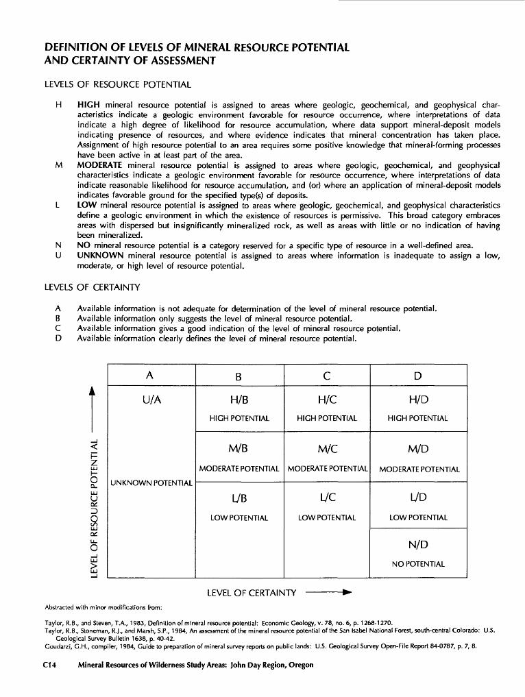
DEFINITION OF LEVELS OF MINERAL RESOURCE POTENTIAL AND CERTAINTY OF ASSESSMENT
LEVELS OF RESOURCE POTENTIAL
H HIGH mineral resource potential is assigned to areas where geologic, geochemical, and geophysical char acteristics indicate a geologic environment favorable for resource occurrence, where interpretations of data indicate a high degree of likelihood for resource accumulation, where data support mineral-deposit models indicating presence of resources, and where evidence indicates that mineral concentration has taken place. Assignment of high resource potential to an area requires some positive knowledge that mineral-forming processes have been active in at least part of the area.
M MODERATE mineral resource potential is assigned to areas where geologic, geochemical, and geophysical characteristics indicate a geologic environment favorable for resource occurrence, where interpretations of data indicate reasonable likelihood for resource accumulation, and (or) where an application of mineral-deposit models indicates favorable ground for the specified type(s) of deposits.
L LOW mineral resource potential is assigned to areas where geologic, geochemical, and geophysical characteristics define a geologic environment in which the existence of resources is permissive. This broad category embraces areas with dispersed but insignificantly mineralized rock, as well as areas with little or no indication of having been mineralized.
N NO mineral resource potential is a category reserved for a specific type of resource in a well-defined area.U UNKNOWN mineral resource potential is assigned to areas where information is inadequate to assign a low,
moderate, or high level of resource potential.
LEVELS OF CERTAINTY
A Available information is not adequate for determination of the level of mineral resource potential.B Available information only suggests the level of mineral resource potential.C Available information gives a good indication of the level of mineral resource potential.D Available information clearly defines the level of mineral resource potential.
h- ZLJJ
oQ_ LJJU
o_JLJJ >
A
U/A
i^/i TI i\i TI\-/VV IN rui CIN i i/\i_
B
H/B
HIGH POTENTIAL
M/B
MODERATE POTENTIAL
L/B
LOW POTENTIAL
C
H/C
HIGH POTENTIAL
M/C
MODERATE POTENTIAL
L/C
LOW POTENTIAL
D
H/D
HIGH POTENTIAL
M/D
MODERATE POTENTIAL
I/O
LOW POTENTIAL
N/D
NO POTENTIAL
LEVEL OF CERTAINTY
Abstracted with minor modifications from:
Taylor, R.B., and Steven, T.A., 1983, Definition of mineral resource potential: Economic Geology, v. 78, no. 6, p. 1268-1270.Taylor, R.B., Stoneman, R.J., and Marsh, S.P., 1984, An assessment of the mineral resource potential of the San Isabel National Forest, south-central Colorado: U.S.
Geological Survey Bulletin 1638, p. 40-42. Goudarzi, G.H., compiler, 1984, Guide to preparation of mineral survey reports on public lands: U.S. Geological Survey Open-File Report 84-0787, p. 7, 8.
C14 Mineral Resources of Wilderness Study Areas: John Day Region, Oregon
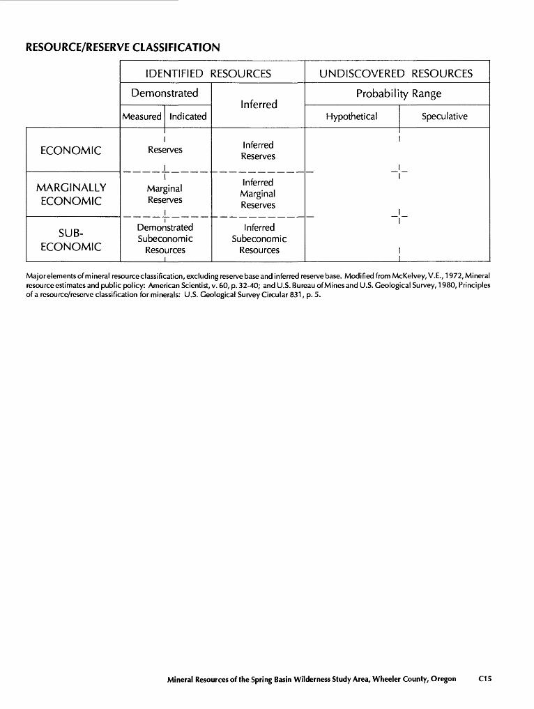
RESOURCE/RESERVE CLASSIFICATION
ECONOMIC
MARGINALLY ECONOMIC
SUB-
ECONOMIC
IDENTIFIED RESOURCES
Demonstrated
Measured
Rese
Indicated
jrves
Marginal Reserves
Demonstrated Subeconomic
Resources
Inferred
Inferred Reserves
Inferred Marginal Reserves
Inferred Subeconomic
Resources
UNDISCOVERED RESOURCES
Probability Range
Hypothetical Speculative
_
Major elements of mineral resource classification, excluding reserve base and inferred reserve base. Modified from McKelvey, V.E., 1972, Mineral resource estimates and public policy: American Scientist, v. 60, p. 32-40; and U.S. Bureau of Mines and U.S. Geological Survey, 1980, Principles of a resource/reserve classification for minerals: U.S. Geological Survey Circular 831, p. 5.
Mineral Resources of the Spring Basin Wilderness Study Area, Wheeler County, Oregon C15
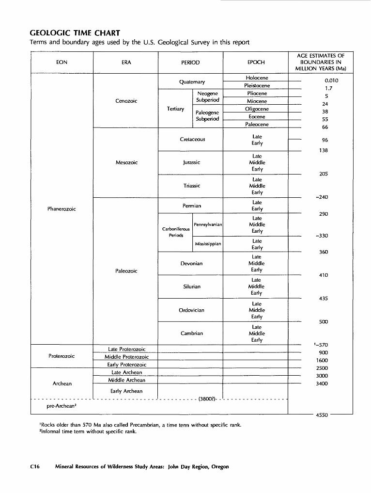
GEOLOGIC TIME CHARTTerms and boundary ages used by the U.S. Geological Survey in this report
EON
Phanerozoic
Proterozoic
pre-Archean2
ERA
Cenozoic
Mesozoic
Paleozoic
Late Proterozoic
Middle Proterozoic
Early Proterozoic
Late Archean
Middle Archean
Early Archean
PERIOD
NeogeneSubperiod
TertiaryPaleogene
Cretaceous
Jurassic
Triassic
Permian
Pennsylvanian Carboniferous
Mississippian
Devonian
Silurian
Ordovician
Cambrian
fi Qr\f\7\
EPOCH
Holocene
Pleistocene
Pliocene
Miocene
Oligocene
Eocene
Paleocene
LateEarly
Late Middle
Early
Late Middle
Early
Late Early
Late Middle
Early
Late Early
Late Middle
Early
Late Middle
Early
Late Middle
Early
Late Middle
Early
AGE ESTIMATES OF BOUNDARIES IN
MILLION YEARS (Ma)
0.010
1.7
5
243 Q
55
66
96
1 ia
205
~?/in
Z7U
-330
J\J\J
410
n T r*
JWW
~ J/ \J
1600
^+J\J\J
JULAJ
J*tlu/V/
>iccn
'Rocks older than 570 Ma also called Precambrian, a time term without specific rank, informal time term without specific rank.
C16 Mineral Resources of Wilderness Study Areas: John Day Region, Oregon
Mineral Resources of Wilderness Study Areas: John Day Region, Oregon
This volume was published as separate chapters A-C
U.S. GEOLOGICAL SURVEY BULLETIN 1743
DEPARTMENT OF THE INTERIOR
DONALD PAUL MODEL, Secretary
U.S. GEOLOGICAL SURVEY
Dallas L. Peck, Director
CONTENTS
[Letters designate the separately published chapters]
(A) Mineral Resources of the Lower John Day and Thirtymile Wilderness Study Areas, Sherman and Gilliam Counties, Oregon, by Jay A. Ach, Scott A. Minor, James G. Frisken, Richard J. Blakely, Harry W. Campbell, and Edward L. McHugh.
(B) Mineral Resources of the North Pole Ridge Wilderness Study Area, Sherman and Gilliam Counties, Oregon, by Scott A. Minor, Jay A. Ach, James G. Frisken, Richard J. Blakely, and Harry W. Campbell.
(C) Mineral Resources of the Spring Basin Wilderness Study Area, Wheeler County, Oregon, by Jay A. Ach, Scott A. Minor, James G. Frisken, Richard J. Blakely, Richard A. Winters, and Thomas J. Peters.


GPO 685-041/9780
SELECTED SERIES OF U.S. GEOLOGICAL SURVEY PUBLICATIONS
Periodicals
Earthquakes & Volcanoes (issued bimonthly). Preliminary Determination of Epicenters (issued monthly).
Technical Books and Reports
Professional Papers are mainly comprehensive scientific reports of wide and lasting interest and importance to professional scientists and en gineers. Included are reports on the results of resource studies and of topographic, hydrologic, and geologic investigations. They also include collections of related papers addressing different aspects of a single scien tific topic.
Bulletins contain significant data and interpretations that are of last ing scientific interest but are generally more limited in scope or geographic coverage than Professional Papers. They include the results of resource studies and of geologic and topographic investigations; as well as collections of short papers related to a specific topic.
Water-Supply Papers are comprehensive reports that present sig nificant interpretive results of hydrologic investigations of wide interest to professional geologists, hydro legists, and engineers. The series covers investigations in all phases of hydrology, including hydrogeology, availability of water, quality of water, and use of water.
Circulars present administrative information or important scientific information of wide popular interest in a format designed for distribution at no cost to the public. Information is usually of short-term interest.
Water-Resources Investigations Reports are papers of an interpre tive nature made available to the public outside the formal USGS publi cations series. Copies are reproduced on request unlike formal USGS publications, and they are also available for public inspection at depositories indicated in USGS catalogs.
Open-File Reports include unpublished manuscript reports, maps, and other material that are made available for public consultation at depositories. They are a nonpermanent form of publication that may be cited in other publications as sources of information.
Maps
Geologic Quadrangle Maps are multicolor geologic maps on topographic bases in 71/2- or 15 -minute quadrangle formats (scales main ly 1:24,000 or 1:62,500) showing bedrock, surficial, or engineering geol ogy. Maps generally include brief texts; some maps include structure and columnar sections only.
Geophysical Investigations Maps are on topographic or planimetric bases at various scales; they show results of surveys using geophysical techniques, such as gravity, magnetic, seismic, or radioactivity, which reflect subsurface structures that are of economic or geologic significance. Many maps include correlations with the geology.
Miscellaneous Investigations Series Maps are on planimetric or topographic bases of regular and irregular areas at various scales; they present a wide variety of format and subject matter. The series also in cludes 71/2-minute quadrangle photogeologic maps on planimetric bases which show geology as interpreted from aerial photographs. Series also includes maps of Mars and the Moon.
Coal Investigations Maps are geologic maps on topographic or planimetric bases at various scales showing bedrock or surficial geol ogy, stratigraphy, and structural relations in certain coal-resource areas.
Oil and Gas Investigations Charts show stratigraphic information for certain oil and gas fields and other areas having petroleum potential.
Miscellaneous Field Studies Maps are multicolor or black-and- white maps on topographic or planimetric bases on quadrangle or ir regular areas at various scales. Pre-1971 maps show bedrock geology in relation to specific mining or mineral-deposit problems; post-1971 maps are primarily black-and-white maps on various subjects such as environmental studies or wilderness mineral investigations.
Hydrologic Investigations Atlases are multicolored or black-and- white maps on topographic or planimetric bases presenting a wide range of geohydrologic data of both regular and irregular areas; principal scale is 1:24,000 and regional studies are at 1:250,000 scale or smaller.
Catalogs
Permanent catalogs, as well as some others, giving comprehen sive listings of U.S. Geological Survey publications are available under the conditions indicated below from the U.S. Geological Survey, Books and Open-File Reports Section, Federal Center, Box 25425, Denver, CO 80225. (See latest Price and Availability List)
"Publications of the Geological Survey, 1879-1961" may be pur chased by mail and over the counter in paperback book form and as a set of microfiche.
"Publications of the Geological Survey, 1962-1970" may be pur chased by mail and over the counter in paperback book form and as a set of microfiche.
"Publications of the U.S. Geological Survey, 1971-1981" may be purchased by mail and over the counter in paperback book form (two volumes, publications listing and index) and as a set of microfiche.
Supplements for 1982,1983,1984,1985,1986, and for subsequent years since the last permanent catalog may be purchased by mail and over the counter in paperback book form.
State catalogs, "List of U.S. Geological Survey Geologic and Water-Supply Reports and Maps For (State)," may be purchased by mail and over the counter in paperback booklet form only.
"Price and Availability List of U.S. Geological Survey Publica tions," issued annually, is available free of charge in paperback book let form only.
Selected copies of a monthly catalog "New Publications of the U.S. Geological Survey" available free of charge by mail or may be obtained over the counter in paperback booklet form only. Those wishing a free subscription to the monthly catalog "New Publications of the U.S. Geological Survey" should write to the U.S. Geological Survey, 582 National Center, Reston, VA 22092.
Note. Prices of Government publications listed in older catalogs, announcements, and publications may be incorrect Therefore, the prices charged may differ from the prices in catalogs, announcements, and publications.
;.:'
*, *^'?
{iij
jV;
*. U>
. .f.
,
,-!t'
. ,*
-
^T