Embed Size (px)
Citation preview
UNITED STATES DEPARTMENT OF THE INTERIOR BUREAU OF MINES
Mineral investigation of the Hells Gate Roadless Area,Gila County, Arizona:
U.S. Bureau of Mines Mineral Land Assessment MLA 139-82
1982
By McColly, R.A.
This open file report summarizes the results of a Bureau of Mines wildemess study and will be incorporated in a joint report with the U.S. Geological Survey. The report is preliminary and has not been edited or reviewed for conformity with the U.S. Bureau of Mines editorial standards. Work on this study was conduced by personnel from Intermountain Field Operations Center, Building 20, Denver Federal Center, Denver, CO 80225.
3
UNITED STATES DEPARTMENT OF THE INTERIOR (BUREAU oF MINES)
MINERAL INVESTIGATION OF THE HELLS GATE ROADLESS AREA, GILA COUNTY, ARIZONA
By Robert A. McColly
MLA 139-82 1982
This open file report summarizes the result~ of a Bureau of Mines wilderness study and will!be incorporated in a joint report with the U.S. Geological Survey. The report is preliminary and has not been edited or reviewed for conformity with the U.S. Bureau of Mines editorial standards. Work on this study was conducted by personnel from Intermountaln Field Operations Center, Building 20, Denver Federal Center, Denver, CO 80225.
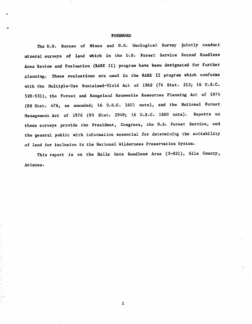
FOREWORD
The U.S. Bureau of Mines and U.S. Geological Survey jointly conduct
mineral surveys of land which in the U.S. Forest Service Second Roadless
Area Review and Evaluation (RARE II) program have been designated for further
planning. These evaluations are used in the RARE II program which conforms
with the Multlple-Use Sustained-Yield Act of 1960 (74 Star. 215; 16 U.S.C.
528-531), the Forest and Rangeland Renewable Resources Planning Act of 1974
(88 Star. 476, as amended; 16 U.S.C. 1601 note), and the National Forest
Management Act of 1976 (90 Star. 2949; 16 U.S.C. 1600 note). Reports on
these surveys provide the President, Congress, the U.S. Forest Service, and
the general public with information essential for determining the suitability
of land for inclusion in the National Wilderness Preservation System.
This report is on the Hells Gate Roadless Area (3-021), Gila County,
Arizona.
CONTENTS
Page
I n t r o d u c t i o n . . . . . . . . . . . . . . . . . . . . . . . . . . . . . . . . . . . . . . . . . . . . . . . . . . . . . 1
L o c a t i o n , s i z e , and g e o g r a p h i c s e t t i n g . . . . . . . . . . . . . . . . . . . . . . 1
Mining a c t i v i t y . . . . . . . . . . . . . . . . . . . . . . . . . . . . . . . . . . . . . . . . . . . . . 3
Mining districts and mineralized areas ........................... 3
Gisela (Spook) barite deposit ............................... 4
Bearhlde Canyon prospects ................................... 4
Iron, uranium, and yttrium prospects ........................ 5
Other prospects ............................................. 5
Conclusions ...................................................... 5
References ....................................................... 6
ILLUSTRATIONS
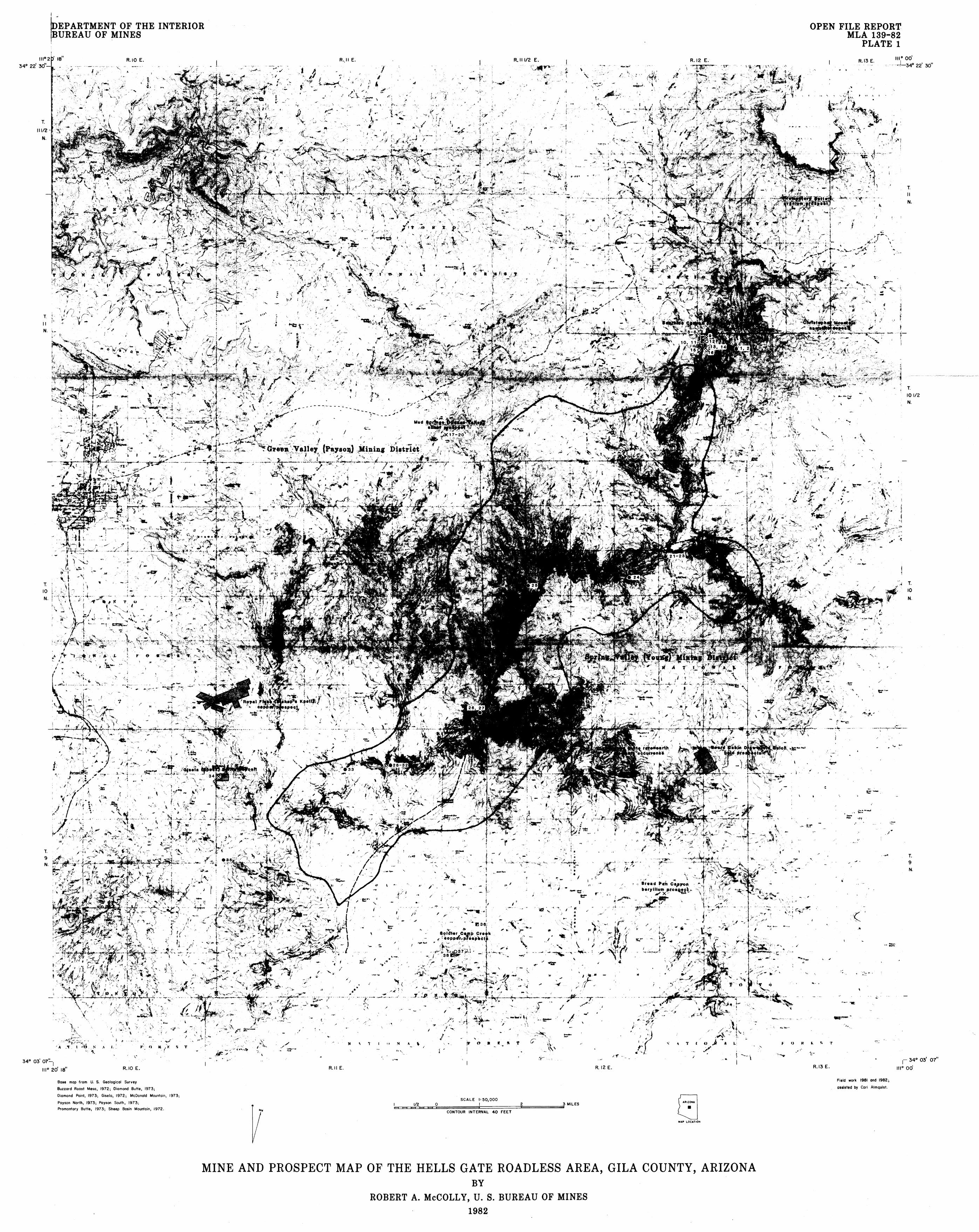
Plate 1. Mine and prospect map of the Hells Gate Roadless Area, at Gila County, Arizona .................................. back
EXPLANATION OF SYMBOLS FOR PLATE 1 ............................... 13
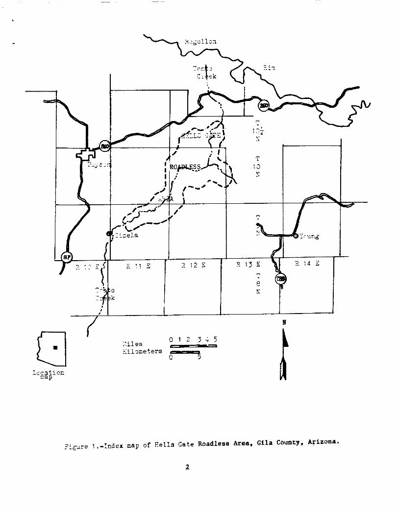
Figure I. Index map of the Hells Gate Roadless Area, Gila County, Arizona ....................................... 2
TABLES
Table I. Mineral deposits near the Hells Gate Roadless Area, Gila County, Arizona ................................... 7
Table 2. Sample information and assay data summary .............. ii
ii
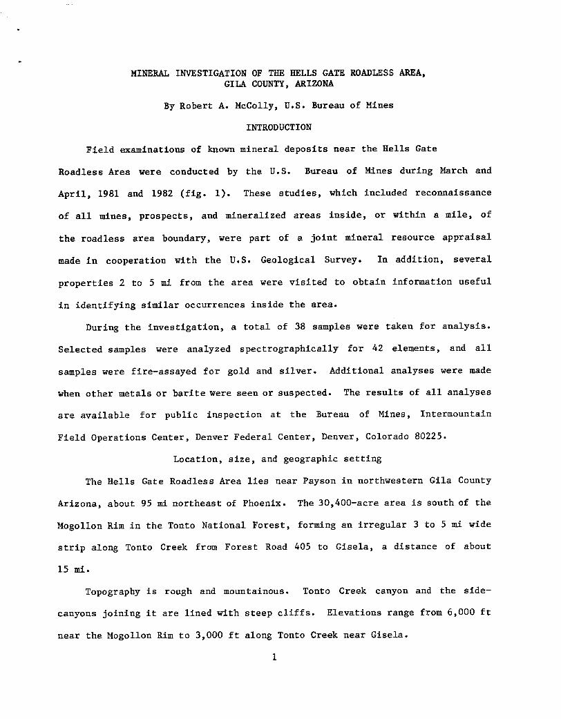
MINERAL INVESTIGATION OF THE HELLS GATE ROADLESS AREA, GILA COUNTY, ARIZONA
By Robert A. McColly, U.S. Bureau of Mines
INTRODUCTION
Field examinations of known mineral deposits near the Hells Gate
Roadless Area were conducted by the U.S. Bureau of Mines during March and
April, 1981 and 1982 (fig. i). These studies, which included reconnaissance
of all mines, prospects, and mineralized areas inside, or within a mile, of
the roadless area boundary, were part of a joint mineral resource appraisal
made in cooperation with the U.S. Geological Survey. In addition, several
properties 2 to 5 mi from the area were visited to obtain information useful
in identifying similar occurrences inside the area.
During the investigation, a total of 38 samples were taken for analysis.
Selected samples were analyzed spectrographically for 42 elements, and all
samples were fire-assayed for gold and silver. Additional analyses were made
when other metals or barite were seen or suspected. The results of all analyses
are available for public inspection at the Bureau of Mines, Intermountaln
Field Operations Center, Denver Federal Center, Denver, Colorado 80225.
Location, size, and geographic setting
The Hells Gate Roadless Area lles near Payson in northwestern Gila County
Arizona, about 95 ml northeast of Phoenix. The 30,400-acre area is south of the
Mogollon Rim in the Tonto National Forest, forming an irregular 3 to 5 mi wide
strip along Tonto Creek from Forest Road 405 to Gisela, a distance of about
15 mi.
Topography is rough and mountainous. Tonto Creek canyon and the side-
canyons joining it are lined with steep cliffs. Elevations range from 6,000 ft
near the Mogollon Rim to 3,000 ft along Tonto Creek near Gisela.
I
>k)go!Icn
C,' ek
;, m
k.--._
~T~ .; :-1_2
o '~ ~
, ' , f , _ _ . - . . t j
- - X
r. !I E -, 2 E " P. , 2 E ~ 13 R 14 E 12
T~ :o N 7_~ ~k
h I
/ Xiles 0 I 2 3 ~ 5
iilometers 0
~ccat.on map
yicare 1.-Index map of Eells Gate Roadless Area, Gila County, Arizona.
2
From Payson, Gisela, and Young, jeep trails and Forest Service roads
provide access to numerous points along the area perimeter. A few Jeep trails
extend short distances into t h e area, but generally access within the area is
only by foot, horse, or helicopter.
Mining activity
The roadless area has no history of mining or mineral production, and no
active claims, mines, or prospects were found inside the area boundaries.
Some prospecting is indicated, based upon a review of mining clalm records in
the Gila County courthouse. Approximately 50 mining clalms were found with
descriptions that could place them within the area, but many descriptions are
vague or even contradictory. Most of these claims were filed before the early
1930's, and none more recently than the 1950's. Bureau of Land Management
records show no mineral leases, permits, or mining claims active in the area
as of September 1982.
MINING DISTRICTS AND MINERALIZED AREAS
Parts of the Green Valley (Payson), and the Spring Creek (Young), mining
districts extend into the Hells Gate Roadless Area, but none of the recorded
mineral production from either district can be attributed to the area. Mine
workings at the Gis~ela (Spook) barite deposit, and in Bea~hlde Canyon provide
the only evidence of mining within 2 mi of the area. Several properties within
a 5-mi radius include occurrences of agate, amethyst, barite, beryllium, copper~
gold, iron, the rare-earth mineral xenotime (yttrium phosphate), silver, and
uranium. The known deposits of iron, uranium, and yttrium, however, are related
to geologic units not found in the area; and though favorable host rocks for
the remaining minerals occur within the area, evidence to support the actual
existence of such occurrences is tentative or lacking.
3
@isela (Spook) barite deposit
A barite vein, 2 to 4 ft wide in granite, was exposed for over I00 ft
along a rldge-top in the NWI/4, sec. 7, T. 9 N., R. ii E., 2 ~ west of the
area (pl I). The deposit is well known, production has occured as recently
as 1981, and is described by Stewart and Pfister (1960, p. 15-16) who cite
values of 93.6 percent BaSO 4, 3.7 percent SiO 2, and 0.5 percent FeO S, with a
specific gravity of 4.29. When visited in April 1982, the vein had been totally
covered with earth and dump material, and the site rehabilitated and seeded.
Only small pieces of barite float could be found where the mine had been. Some
of these were collected for assay (table 2, sample 34). Stewart and Pfister
(1960, p. 12) considered this vein as one of a system of sub-parallel fractures
containing barite that extends south of Payson for about 15 ml. As mapped by
Conway (1976), the structure containing barite at the Spook deposit continues
southeastward for at least 2 mi, extending into the area. No barite was
found along the projection of this structure, however, within a half-mile of
the pit.
Bearhide Canyon prospects
Two water-filled shafts and a few shallow surface workings occur in sec.
24, T. 10-1/2 N., R. 12 E., along a i/2-mi stretch of Bearhlde Canyon just
north of the area. None of the workings appeared to have been active recently.
Fourteen Bureau of Mines samples (table 2, samples 3-16) gave assay values up
to 0.117 ounce gold and 1.9 ounce silver per ton. Minor amounts of azurite
and malachite were found on some of the dumps, but neither was observed in
place. Mineralization is associated with quartz veins and masses occurring in
granite. There is no record of production from mines in this vicinity, and
based on observation, production, if any, was small. Though irregular, the
veins appear to be near vertical, with an average strike of about N 35 ° W.
4
Therefore, the veins do not project into the roadless area either along strike
or down dip.
Iron, uranium, and yttrium prospects
A review of the literature disclosed that iron, uranium, and yttrium
prospects near the Hells Gate Roadless Area are found in host-rocks which are
absent within the area. In this category are the Christopher Mountain hematite
deposit in sec. 36, T. Ii N., R. 12 E., (Harrer, 1964, p. 30); the Promontory
Butte uranium prospect in sec. 24, T. ii N., R. 12 E., (Scarborough, 1981,
p. 184); and the Diamond Butte xenotime (yttrium phosphate) occurrence in
sec. 3, T. 9 N., R. 12 E., (Gastil, 1954, p. 280).
Other prospects
Several other prospects outside of the area were found and examined, most
with scant development work, and generally providing little pertinent informa-
tion on potential mineral deposits in the area. Included in this group are the
A~ggate Mountain agate - amethyst occurrence in sec. 20, T. I0 N., R. ii E.,
(Phillips, 1973, p. i); the nite barite prospect in sec. 15, T. i0 N.,
R. ii E., (Stewart and Pfister, 1960, p. 18-19); the Bre~d Pan Canyon beryllium
prospect in see. 23, T. 9 N., R. 12 E., (Smith, 1962, p. i); the Ro~yal Flush
(Bis~'~ll) copper prospect in see. 36, T. i0 N., R. I0 E., (Lausen and
Wilson, 1925, p. 41); the Soldi~e~ Camp Creek copper prospects in sees. 25 and
36 T. 9 N., R. ii E., and sec. 6, T. 8 N., R. 12 E.; placer and vein gold
G Yol deposits in d Gulch and Board Cabin Draw in sees. 2, ii, and 12, T. 9 N., \
R. 12 E.; and a silver prospect near Mud ~ Springs in sec. 36, T. ii N.,
R. ii E., (tables i and 2). None of these extend into the roadless area;
neither are any similar deposits known to occur within the roadless area.
CONCLUSIONS
U.S. Bureau of Mines studies of the Hells Gate Roadless Area identified
no mineral occurrences within the area.
REFERENCES
Conway, C. M., 1976, Petrology, structure, and evolution of a Precambrian volcanic and plutonic complex, Tonto Basin, Gila County, Arizona (Ph. D dissertation): California Institute of Technology, Pasadena,
460p.
G a s t i l , G. R . , 1954, An o c c u r r e n c e of a u t h i g e n i c x e n o t i m e : J o u r n a l of S e d i m e n t a r y P e t r o l o g y v . 24, no . 4, p . 280-81 .
H a r r e r , C. M., 1964, R e c o n n a i s s a n c e of i r o n r e s o u r c e s i n A r i z o n a : U.S. Bureau of Mines IC 8236, 204p.
La us e n , C . , and W i l s o n , E. D . , 1925, Gold and c o p p e r d e p o s i t s n e a r P a y s o n , A r i z o n a : U n i v e r s i t y o f A r i z o n a , A r i z o n a Bureau o f Mines B u l l e t i n 120,
44 p.
P h i l l i p s , K. A . , 1973, Mine r e p o r t - B e a u t y 1-7 c l a i m s g r o u p ; U n p u b l i s h e d o p e n - f i l e r e p o r t , A r i z o n a Depar tmen t o f M i n e r a l R e s o u r c e s , 1 p .
S c a r b o r o u g h , R. B . , 1981, R a d i o a c t i v e o c c u r r e n c e s and u ran ium p r o d u c t i o n i n A r i z o n a : U n i v e r s i t y o f A r i z o n a , A r i z o n a Bureau of Geology and M i n e r a l
Te chno logy , 297p.
Smi th , L. A . , 1962, Mine r e p o r t - S c o r p i o n b e r y l l i u m mine : U n p u b l i s h e d open - f i l e r e p o r t , A r i z o n a Depar tmen t o f M i n e r a l R e s o u r c e s , 2p.
S t e w a r t , L. A . , and P f i s t e r , A. J . , 1960, B a r i t e d e p o s i t s o f A r i z o n a : U.S. Bureau of Mines El 5651, 89p.
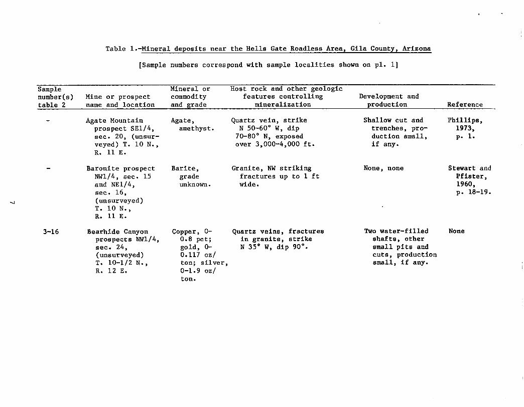
Table l.-Mineral deposits near the Hells Gate Roadless Area, Gila County, Arizona
[Sample numbers correspond with sample localities shown on pl. i]
Sample number(s) table 2
Mine or prospect name and location
Mineral or commodity and grade
Host rock and other geologic features controlling
mineralization Development and
p r o d u c t i o n Reference
3-16
Agate Mountain prospect SEI/4, sec. 20, (unsur- veyed) T. i0 N., R. ii E.
Baronite prospect NWI/4, sec. 15 and NEI/4, sec. 16, (unsurveyed) T. i0 N., R. ii E.
Bearhide Canyon prospects NWl/4, sec. 24, (unsurveyed) T. 10-1/2 N., R. 12 E.
Agate, amethyst.
Barite, grade unknown.
Copper, 0- 0.8 pct; gold, 0- 0.117 oz/ ton; silver, 0-1.9 oz/ ton.
Quartz vein, strike N 50-60 ° W, dip 70-80 ° N, exposed over 3,000-4,000 ft.
Granite, NW striking fractures up to i ft wide.
Quartz veins, £ractures in granite, strike N 35 ° W, dip 90 ° •
Shallow cut and trenches, pro- duction small, if any.
None, none
Two water-filled shafts, other small pits and cuts, production small, if any.
Phillips, 1973, p. I.
Stewart and Pflster, 1960, p. 18-19.
None
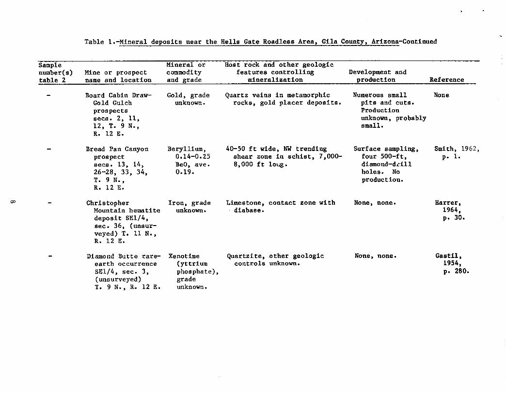
Table l.-Mineral deposits near the Hells Gate Roadless Area, Gila County, Arlzona-Contlnued
Sample number(s) table 2
Mine or prospect name and location
Mineral or commodity and grade
Host rock and other geologic features controlling
mineralization Development and
p r o d u c t i o n Reference
OO
Board Cabin Draw- Gold Gulch prospects secs. 2, Ii, 12, T. 9 N., R. 12 E.
Bread Pan Canyon prospect secs. 13, 14, 26-28, 33, 34, T. 9 N., R. 12 E.
Christopher Mountain hematite deposit SEI/4, sec. 36, (unsur- veyed) T. Ii N., R. 12 E.
Diamond Butte rare- earth occurrence SEI/4, sec. 3, (unsurveyed) T. 9 N., R. 12 E.
Gold, grade unknown.
Beryllium, 0.14-0.25 BeO, ave. 0.19.
Iron, grade unknown.
Xenotlme (yttrium phosphate), grade unknown.
Quartz veins in metamorphic rocks, gold placer deposits.
40-50 ft wide, NW trending shear zone in schist, 7,000- 8,000 ft io]~.
Limestone, contact zone with dlabase.
Quartzite, other geologic controls unknown.
Numerous small plts and cuts. Production unknown, probably small.
Surface sampling, four 500-ft, diamond-d£ill holes. No production.
None, none,
None, none.
None
Smith, 1962, p. I.
Hatter, 1964, p. 30.
Gastil, 1954, p. 280.
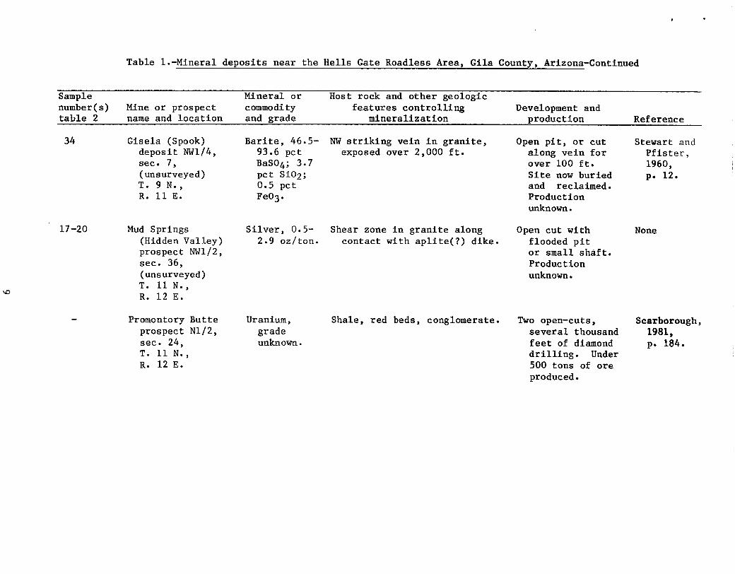
Table l.-Mineral deposits near the Hells Gate Roadless Area, Gila County, Arizona-Continued
Sample number(s) table 2
Mine or prospect name and location
Mineral or commodity and grade
Host rock and other geologic features controlling
mineralization Development and
production Reference
34
17-20
Gisela (Spook) deposit NWI/4, sec. 7, (unsurveyed) T. 9 N., R. ii E.
Mud Springs (Hidden Valley) prospect NWI/2, sec. 36, (unsurveyed) T. ii N., R. 12 E.
Promontory Butte prospect NI/2, see. 24, T. Ii N., R. 12 E.
Barite, 46.5- NW striking vein in granite, 93.6 pct exposed over 2,000 ft. BaS04; 3.7 pct SiO2; 0.5 pct FeO 3.
Silver, 0.5- Shear zone in granite along 2.9 oz/ton, contact with aplite(?) dike.
Uranium, grade unknown.
Shale, red beds, conglomerate.
Open pit, or cut along vein for over i00 ft. Site now buried and reclaimed. Production unknown.
Open cut with flooded pit or small shaft. Production unknown.
Two open-cuts, several thousand feet of diamond drilling. Under 500 tons of ore produced.
Stewart and Pfister, 1960, p. 12.
None
Scarborough, 1981, p. 184.
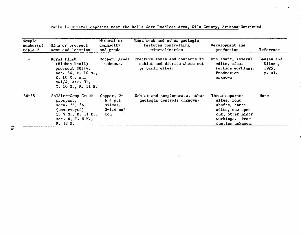
Table l.-Mineral deposits near the Hells Gate Roadless Area, Gila County, Arlzona-Contlnued
Sample number(s) table 2
Mine or prospect name and location
Mineral or commodity and grade
Host rock and other geologic features controlling
mineralization Development and
production R e f e r e n c e
36-38
Royal Flush (Bishop Knoll) prospect NEI/4, sec. 36, T. i0 N., R. i0 E., and NWI/4, see. 31, T. i0 N., R. ii E.
Soldier-Camp Creek prospect, secs. 25, 36, (unsurveyed) T. 9 N., R. ii E., see. 6, T. 8 N., R. 12 E.
Copper, grade Fracture zones and contacts in unknown, schist and diorite where cut
by basic dikes.
Copper, 0- 6.4 pet silver, 0-1.6 oz/ ton.
Schist and conglomerate, other geologic controls unknown.
One shaft, several adlts, minor surface workings. Production unknown.
Three separate sites, four shafts, three adits, one open cut, other minor workings. Pro- duction unknown.
Lausen an~ Wilson, 1925, p. 41.
None
O
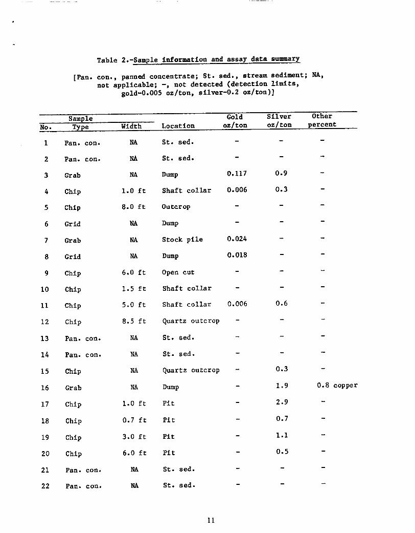
Table 2 . -Sample i n f o r m a t i o n and a s say d a t a summary
[Pan. con., panned concentrate; St. sed., stream sediment; NA,
not appllcable; -, not detected (detection limits,
gold-0.005 oz/ton, silver-0.2 oz/ton)]
NO •
Sample Gold Silver Other
Type Width Location oz/ton oz/ton percent
i
2
3
4
5
6
7
8
9
I0
II
12
13
14
15
16
17
18
19
20
21
22
Pan• con. NA St. sed. - -
Pan. con. NA St. sed. - -
Grab NA Dump 0.117 0.9
Chip 1.0 ft Shaft collar 0.006 0.3
Chip 8.0 ft Outcrop - -
Grid NA Dump - -
Grab NA Stock plle 0.024 -
Grid NA Dump 0.018 -
Chip 6.0 ft Open cut - -
Chip 1.5 ft Shaft collar - -
Chip 5.0 ft Shaft collar 0.006 0.6
Chip 8.5 ft Quartz outcrop - -
Pan. con. NA St. sed. - -
Pan. con. NA St. sed. - -
Chip NA Quartz outcrop - 0.3
Grab NA Dump - 1.9
Chip 1.0 ft Pit - 2.9
Chip 0.7 ft Pit - 0.7
Chip 3.0 ft Pit - i.I
Chip 6.0 ft Pit - 0.5
Pan. con. NA St. sed. - -
Pan. con. NA St. sed. - -
m
0.8 copper
Ii
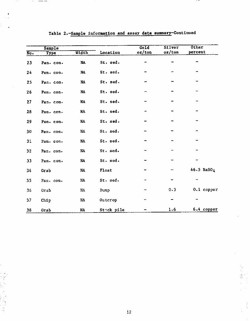
Table 2.-Sample information and assay data summary-Continued
NO •
Sample Gold Silver Type Width Locat ion oz / ton oz / t on
Other percent
23
24
25
26
27
28
29
30
31
32
33
34
35
36
37
38
Pan. con. NA St. sed.
Pan. con. NA St. sed.
Pan. con. NA St. sed.
Pan. con. NA St. sed.
Pan. con. NA St. sed.
Pan. con. NA St. sed.
Pan. con. NA St. sed.
Pan. con. NA St. sed.
Pan. con. NA St. sed.
Pan. con. NA St. sed.
Pan. con. NA St. sed.
Grab NA Float
Pan. con. NA St. sed.
Grab NA Dump
Chip NA Outcrop
Grab NA St~ck pile
m
0.3
1.6
m
46.5 BaSO 4
0.I copper
6.4 copper
iliill 'I,
!!ili ~
12
D m m m
012
e l , 2
×S
I~ 3e
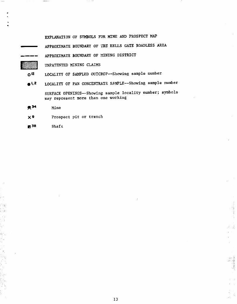
EXPLANATION OF SYMBOLS FOR MINE AND PROSPECT MAP
APPROXIMATE BOUNDARY OF ~HE HELLS GATE ROADLESS AREA
APPROXIMATE BOUNDARY OF ~NING DISTRICT
UNPATENTED MINING CLAIMS
LOCALITY OF SAMPLED OUTCROP--Showing sample number
LOCALITY OF PAN CONCENTRATE S~MPLE--Showing sample number
SURFACE OPENINGS--Showing sample locality number; symbols may represent more than one working
Mine
Prospect pit or trench
Shaft
ili !i ...... !ii! ~I~,
13