Embed Size (px)
Citation preview
1
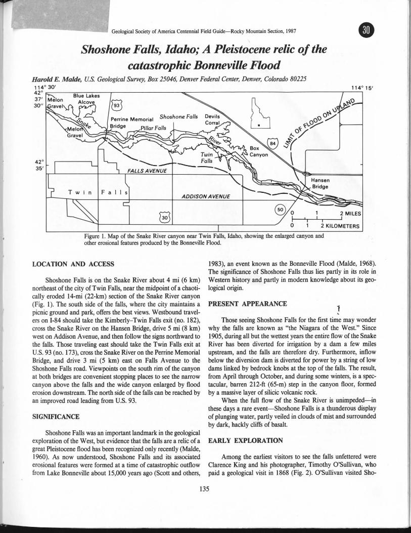
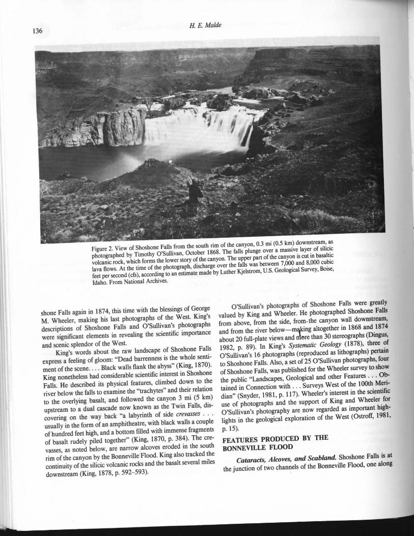
Milner Dam, Cauldron Linn, Shoshone
Falls, and Box Canyon
Geology of Idaho (Geol 4456/5556), Geomorph (6602) and Evol. of Earth’s Surface (Geol 3315)
Dr. Paul Link and Dr. Ben Crosby
4/15/2017
Box Canyon
2
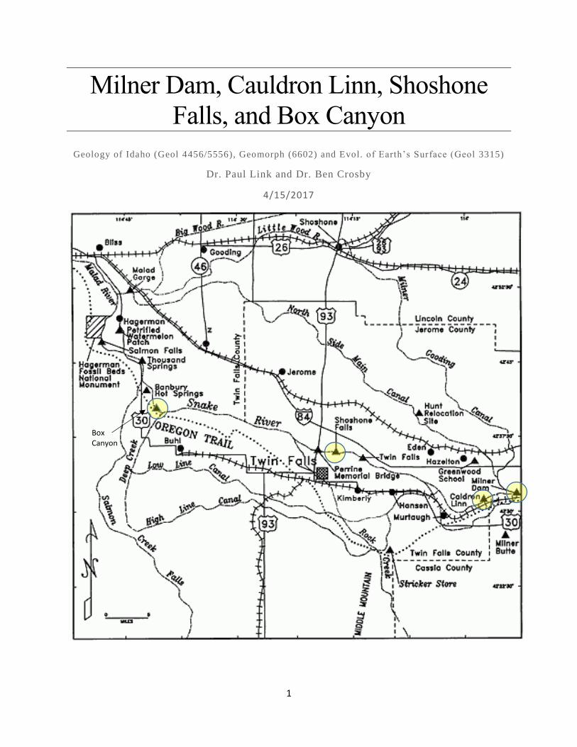
Milner Dam to Cauldron Linn
Cauldron Linn to Shoshone Falls overlook
Shoshone Falls overlook to Box Canyon
3
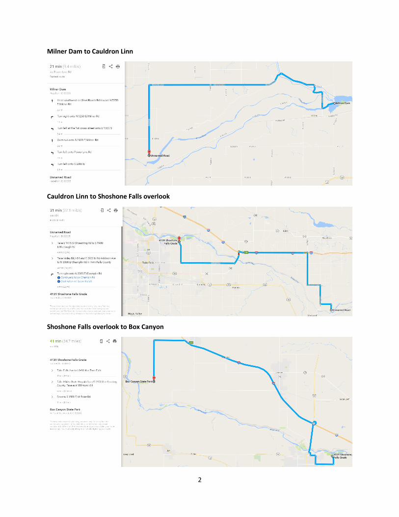
The Bonneville Flood
Milner Dam
From O’Conner,
1993
From O’Conner, 1993
4
The Story of Milner Dam
(Joe Yost –Dam Tender)
In 1900 the entire strip of country we know as the Magic Valley was but a vast desert covered with sagebrush. The
irrigation works had not been commenced, and in fact, the whole scheme of irrigation was little more than a dream
Milner Dam came about because of the vision of Ira Burton Perrine, a rancher who had developed a Shoshone Falls
resort and a Blue Lakes farm down stream. Perrine chose the site of the dam and acted as his own engineer. He
obtained financing for the project through Stanley B. Milner, a banker and financier from Salt Lake City, and
easterners Frank H. Buhl and Peter L. Kimberly. As a result, the Buhl-Kimberly Corp. was formed and in 1903 a
contract was entered into between the State of Idaho and the Twin Falls Land and Water Co. for construction of the
project. The dam was formed by three earth and rockfilled embankments, abutting against the river banks and two
islands. In 1905 construction on the dam was completed. Men with mules and scrapers had also finished their work
on the canals and all was ready for the water."On March 1, 1905, Frank Buhl gave a ceremonial pull on the wheel on
a winch and the gates of Milner Dam were closed, and the gates to a thousand miles of canal and laterals were
opened, and the Snake River was diverted, and that night Shoshone Falls went dry as the water rushed across the
desert far above, and Perrine's vision was realized, and 262,000 acres of desert were shortly transformed." Milner
Dam and its canal system have national significance in agricultural history. They are one of the rare examples of
successful state supervised private irrigation development. The dam performed well for decades. There were
instances of leakage through the dam that required immediate repair, but it fulfilled its purpose and today provides
irrigation water to more than 500,000 acres of prime Idaho farmland. After decades of use the dam began to show
signs of aging. In December 1988, the Federal Energy Regulatory Commission's Division of Dam Safety and
Inspection determined there was a high risk of Milner Dam failing during an earthquake unless it was rebuilt. The
price tag to rebuild the dam was about $11 million. The Twin Falls and North Side canal companies determined that
the costs of reconstruction would result in severe economic hardship to their 7,500 shareholders who depend on
irrigation water from the dam for their livelihoods. To pay for reconstruction the canal companies made a mutually
beneficial agreement with Idaho Power to rehabilitate the dam and build a new 57.5-megawatt power plant
downstream. Idaho Power would loan the canal companies funds to refurbish the dam. Repayment would come in
the form of royalties from the hydro project. The new Milner power plant has two main generating units, one with
an 11.5-megawatt generating capacity and the other with 46 megawatts of capacity. A small 800-kilowatt
powerhouse also has been built at the dam to take advantage of minimum streamflows that must be spilled at the
dam to maintain a flow in the main river channel.
FACTS ABOUT THE PROJECT
Milner is Idaho Power's 17th hydroelectric power plant.
The power generating facilities cost approximately $56 million.
Up to 5,200 cfs of water, which would previously have been spilled, generates low-cost energy.
Spillway capacity of 116,750 cfs provides the capability to safely handle flood flows.
5
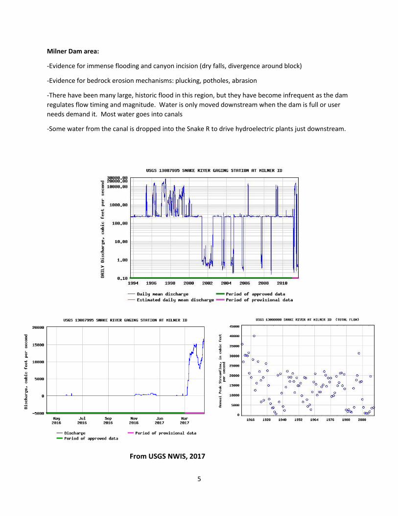
Milner Dam area:
-Evidence for immense flooding and canyon incision (dry falls, divergence around block)
-Evidence for bedrock erosion mechanisms: plucking, potholes, abrasion
-There have been many large, historic flood in this region, but they have become infrequent as the dam
regulates flow timing and magnitude. Water is only moved downstream when the dam is full or user
needs demand it. Most water goes into canals
-Some water from the canal is dropped into the Snake R to drive hydroelectric plants just downstream.
From USGS NWIS, 2017
6
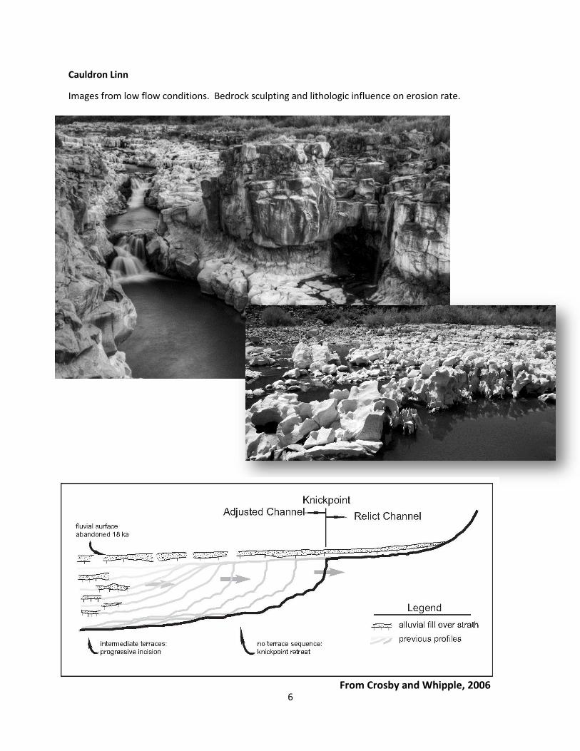
Cauldron Linn
Images from low flow conditions. Bedrock sculpting and lithologic influence on erosion rate.
From Crosby and Whipple, 2006
7
8
9
10
11
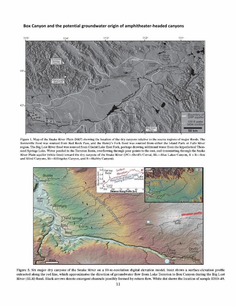
Box Canyon and the potential groundwater origin of amphitheater-headed canyons