Embed Size (px)
Citation preview

Millersville at Fall Creek Valley Village and Corridor Plan
City of Indianapolis Department of Metropolitan Development Division of Planning Re-Adopted November 4, 2015 2015-CPS-R-002
City of Indianapolis Department of Metropolitan Development Division of Planning Re-Adopted November 4, 2015 2015-CPS-R-002


City of Indianapolis - Marion County | 1
Introduction This document is a plan for maintaining and enhancing the stability, livability and
sustainability of the Millersville at Fall Creek Valley community.
This plan is a guide for anyone making a decision about the use of a property within the
study area. It is useful for property owners, developers, neighbors and neighborhood
organizations, City staff and City boards and commissions. This plan will be used to
evaluate rezoning applications, to project future population and employment
concentrations, and prioritize capital improvements.
This plan is also a comprehensive plan segment. A comprehensive plan is required by
state statute (Indiana Code 36-7-4-501 through 512) as a basis for zoning and must
include objectives and policies for future land use development and development of
public ways, places, land, structures and utilities. A comprehensive plan segment is one
part of the overall comprehensive plan for the county. The Comprehensive Plan for
Indianapolis/Marion County is made up of over 80 segments.
Two types of comprehensive plan segments are combined in this plan:
• a village plan focused on the retail area centered on the intersection of Emerson
Way and 56th Street and the historic town of Millersville, and
• a corridor plan focused on Fall Creek and its adjacent neighborhoods.
Previous Plan
The previous plan of record for the study area of this plan was Indianapolis Insight: the
Comprehensive Plan for Marion County, Indiana. This plan was composed of two
components: a Community Values Component that contains planning objectives for the
entire county and a Land Use Component that contains information about
recommended land uses and environmentally sensitive areas on a township by township
basis. The Millersville area falls under the Land Use Components for Washington Township
and Lawrence Township.
Community Values Component
The Community Values Component of Indianapolis Insight contains value statements,
planning principles, goals and 280-plus recommendations for development and

City of Indianapolis - Marion County | 2
redevelopment in Marion County. Copies of the Community Values Component are
available from the Indianapolis Division of Planning and on the City’s website. Although
modified by this plan, the Community Values Component remains a source for general
development guidelines for the study area.
Land Use Component
The Land Use Component of Indianapolis Insight is comprised of three major parts: a
map of environmentally sensitive areas, a map of recommended land uses and text that
provides more insight into a number of Critical Areas that were designated around the
county. The land use portions of this plan replace the land use recommendations of
Indianapolis Insight for the study area.
Information on how this plan relates to other comprehensive plan segments can be
found in Appendix A.
Planning Process
In 2009 a group of concerned neighbors and community leaders gathered to seek
solutions about disinvestment in their local retail area. This led to the formation of the
Millersville at Fall Creek Valley community organization, which unites the common
interests of 27 neighborhoods plus schools, churches, businesses and institutions. The
organization is committed to:
• Promoting its history, schools, and culture;
• Protecting its waters, parks, and greenways;
• Preserving its diverse neighborhoods;
• Utilizing community resources to safely connect homes, schools, shops, and trails,
• Creating a desirable and unique place to live, learn, work, play, and stay.
In early 2010 the Millersville at Fall Creek Valley organization came together with the
Indianapolis Division of Planning to start work on a plan for the area.
A series of interviews, focus group meetings and general meetings were held in spring
and summer of 2010 with residents, businesspeople and representatives of institutions in
the Millersville at Fall Creek Valley area, as well as with staff persons from various City
departments. The purpose of these interactions was to gather information about the

City of Indianapolis - Marion County | 3
area’s assets and resources, and to hear and understand the participants’ issues,
concerns and visions for the area.
The input from the interviews, focus groups and general meetings was organized into four
general subject areas. Work Groups were established around each topic: Fall Creek,
Connectivity, Neighborhoods and the Village of Millersville. Each Work Group met four to
nine times starting in October 2010 and running through October 2011. Each Work Group
was expected to study its topic, set goals and actions, prioritize those goals and actions,
and then issue a report.
The four Work Group reports were combined with other materials to form this document.
A meeting was held in December 2011 to review the final draft of the plan and prioritize
the plan recommendations. A series of three meetings were held in April and May of
2012 to wrap up loose ends and provide the public with a final chance to review the
document prior to its submission for approval by the Metropolitan Development
Commission.

City of Indianapolis - Marion County | 4

City of Indianapolis - Marion County | 5
History Various strands of Indianapolis history come together in the Millersville at Fall Creek Valley
community. Seth Bacon and Peter Negley built a sawmill on Fall Creek at what is now
Millersville in 1824. The village itself dates from 1838. The town’s heyday seems to have
been the 1840s through 1860s. During this time a grist mill and distillery were operated in
the town by William Winpenny and Jacob Spahr. Just a handful of historic structures,
including the Winpenny home and a general store, remain.
The idea of a parkway along Fall Creek originated in the early days of park planning in
Indianapolis. In 1909 George Kessler proposed acquiring land along Fall Creek from the
White River upstream to 38th Street and beyond as the city grew. By 1911 the City had
acquired the entire north bank of the creek from 23rd Street upstream beyond the City
limits at 38th Street. The parkway was built with open spaces and tree-lined, curvilinear
roadways.
In 1909 a ravine-cut wooded parcel overlooking Fall Creek was offered to the City by
William Watson Woollen. Although the parcel was well outside City limits, the City
accepted Woollen’s offer. The donation of Woollens Garden was an impetus to extend
the parkway another six miles. Woollens Garden was dedicated as a state nature
preserve in 1987 as an excellent example of an old, second-growth mesic upland forest
community dominated by red oak, sugar maple, white oak, shagbark hickory and ash.
Upon completion of a park master plan in 1988 a paved recreation trail was constructed
along Fall Creek from Binford Boulevard/Allisonville Road to 56th Street. In 2007 an
extension to the fall Creek Trail was made as far upstream as Woollens Garden.
In the early part of the 20th century the area around Millersville was known for its diary
farms. Little, if any, commercial development took place in the area until after Emerson
Way was built in 1962. The new Emerson Way bridge supplanted the historic Millersville
Road bridge and opened the area to easier travel from the south.
Residential development in the area was also very limited until the post-World War Two
building boom of the 1950s and 1960s. Notable exceptions to this were Laurel Hall and
Brendonwood.

City of Indianapolis - Marion County | 6
Laurel Hall was the country estate home of banker Stoughton Fletcher and his wife May.
It was completed in 1916 on a bluff overlooking Fall Creek and the remains of Millersville.
Laurel Hall sat on an estate of nearly 1500 acres that included most of the area between
46th and 56th streets west of Arlington Avenue and southeast of Fall Creek. Today the
38,000 square-feet mansion is an office and event center. Fletcher’s estate was divided
and developed into eleven residential communities and Cathedral High School.
Brendonwood was established by developer Charles S. Lewis in 1917. Lewis retained
George Kessler to plan and design Brendonwood as a place for fine country living. One
hundred ten lots were laid out on 250 acres between 56th Street and Fall Creek. Kessler’s
design worked with the contours of the ravine-cut stream bluff location and took
advantage of the wooded hillsides. An additional 100 acres were reserved as common
space for roadways, walking and bridle paths, a golf course and other park and
recreation amenities.
The post-War period was a time of explosive growth within the study area. With a few
notable exceptions, by the mid1960s most of the developable land in the study area had
been developed. The 1970s and 80s saw the development of the Windridge
condominium community and the 1980s, 1990s and 2000s was the time of development
for the area between Fall Creek Parkway and Fall Creek Road.
Additional information on the history of the study area can be found in Appendix B.

City of Indianapolis - Marion County | 7
Plan Recommendations for Fall Creek Fall Creek’s source is found south of Middletown in Henry County, Indiana. It flows
southwestwardly for 75 miles and empties into White River in downtown Indianapolis,
draining 315 square miles. Fall Creek is a major source of Indianapolis’s drinking water.
Through the study area Fall Creek is lined along its northern bank by Fall Creek Parkway
and the Fall Creek Greenway Trail. The trail is the third most popular trail in the
Indianapolis Greenways system after the Monon Rail-Trail and the Indianapolis Water
Company Canal.
Fall Creek Trail: Number of Users by Month
At Alsuda Drive High Low Average
2007 6609 (Aug) 596(Jan) 3778
2008 8152 (Aug) 409 (Jan) 3368
2009 8195 (Aug) 1181 (Jan) 4558
2010 6072 (July) 592 (Feb) 3785
At Bosart Avenue High Low Average
2007 6545 (June) 829 (Feb) 3876
2008 7979 (Sept) 602 (Feb) 3357
2009 7867 (Aug) 1742 (Feb) 4653
2010 6251 (June) 709 (Feb) 3706
Trail user counts are highly weather dependent and range from 400 a month in harsh winter weather to over 8000 a month in pleasant summer weather. Water Quality
A watershed management plan for lower Fall Creek, prepared for the Marion County Soil
& Water Conservation District and the Lower Fall Creek Watershed Alliance, examines
water quality issues in the watershed and identifies sustainable, local solutions.
The study area of the watershed plan was the portion of the Fall Creek watershed
downstream of the Geist dam. The Indian Creek, Mud Creek and Devon Creek
watersheds were included in the study because these streams enter Fall Creek
downstream of the dam. The watershed drains 57,800 acres and spreads over four
counties. The entire study area for the Millersville at Fall Creek Valley Village and Corridor
Plan lies within the study area for the watershed plan.

City of Indianapolis - Marion County | 8
The watershed plan was organized by type of pollutant: sediment, nutrients and
pathogens. The watershed plan also identified Critical Areas, which are locations or
activities that particularly contribute to, or are particularly sensitive to, the degradation of
water quality in Fall Creek. The following sections rely heavily on the watershed plan.
Sediment Sediment refers to soil particles washed or blown into a stream. Erosion is a natural
phenomenon. A healthy stream will balance water flow, sediment loads and overall
shape of the stream and energy of the water flow. Excess erosion caused by human
disturbances can increase sedimentation to an unhealthy level. Sediment reduces the
amount of sunlight that reaches aquatic plants, which in turn reduces the availability of
fish cover and food. Sediment also impacts fish by covering spawning areas. It affects
other aquatic wildlife such as mussels, turtles, frogs and insects. Sediment tends to
increase drinking water treatment costs, and reduces water clarity and aesthetic value.
The watershed plan identified four Critical Areas for sediment. Two of these critical areas
are pertinent to the Millersville at Fall Creek Valley area:
• Lack of adequate erosion and sediment control during construction
• Streambank erosion
Public input gathered for this plan also identified issues related to sediment:
• Streambank erosion in general and specifically at Woollens Garden and
Windridge Condominiums
• Deposition of sediment forming a sandbar at the Emerson Way bridge
Streambank erosion threatens to undermine portions of Millersville Road west of Emerson
Way and breach the embankment separating the stream and Mallard Lake, which lies
on the cutbank side of a Fall Creek meander curve. Perhaps the most visually dramatic
example of streambank erosion is the cutbank at Windridge Condominiums. The bank is
located on the outside of Fall Creek’s curve around the original site of Millersville and is 25
feet high. An increasing number and intensity of high water events accelerates the
natural erosion along such curves.
Streambanks in the area are also prone to erosion from seepage. Seepage is a product
of the movement of groundwater through the earth. High water in streams effectively
dams the normal seepage of groundwater and thus raises the water pressure in the river
City of Indianapolis - Marion County | 9
bank. When the high stream water recedes, the pent-up groundwater seeps through
the wall of the cutbank with greater energy and creates additional erosion.
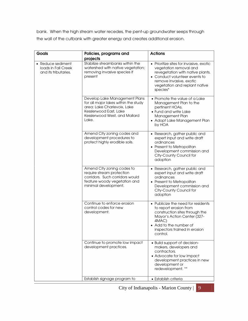
Goals Policies, programs and projects
Actions
• Reduce sediment loads in Fall Creek and its tributaries.
Stabilize streambanks within the watershed with native vegetation; removing invasive species if present
• Prioritize sites for invasive, exotic vegetation removal and revegetation with native plants.
• Conduct volunteer events to remove invasive, exotic vegetation and replant native species*
Develop Lake Management Plans for all major lakes within the study area: Lake Charlevoix, Lake Kesslerwood East, Lake Kesslerwood West, and Mallard Lake.
• Promote the value of a Lake Management Plan to the pertinent HOAs.
• Fund and write Lake Management Plan
• Adopt Lake Management Plan by HOA
Amend City zoning codes and development procedures to protect highly erodible soils.
• Research, gather public and expert input and write draft ordinances
• Present to Metropolitan Development commission and City-County Council for adoption
Amend City zoning codes to require stream protection corridors. Such corridors would feature woody vegetation and minimal development.
• Research, gather public and expert input and write draft ordinances
• Present to Metropolitan Development commission and City-County Council for adoption
Continue to enforce erosion control codes for new development.
• Publicize the need for residents to report erosion from construction sites through the Mayor’s Action Center (327-4MAC)
• Add to the number of inspectors trained in erosion control.
Continue to promote low impact development practices.
• Build support of decision-makers, developers and contractors.
• Advocate for low impact development practices in new development or redevelopment. **
Establish signage program to • Establish criteria

City of Indianapolis - Marion County | 10
identify active construction sites or developments that are in compliance with IDEM’s Rule 5 program.
• Build support among decision-makers and contractors
• Develop signs, inspection forms, tracking
• Train inspectors • Inspect sites, install yard signs
* Volunteer events require significant advance planning of both the project and the event and may include site design, approvals and permits, professional supervision and assistance, and donations of funds, materials and supplies. ** The City’s Green Supplemental Document program offers expedited permitting for projects that include green infrastructure.
Nutrients
Nutrient pollution, particularly nitrogen and phosphorus, can lead to algae blooms,
which reduce plant growth and can lead to fish kills by reducing the amount of oxygen
available in the water. Nutrient pollution can also increase drinking water treatment
costs. Algae blooms in Geist Reservoir in 2007 resulted in recreation use restrictions. The
two main causes of nutrient pollution that are pertinent to the Millersville area are fertilizer
application and inadequately functioning septic systems.
Both residential and commercial lawn care practices are substantial sources of nutrient
pollution. Home-owners who are not trained in chemical application are often prone to
over-apply or mis-apply lawn care products.
The watershed management plan identified two Critical Areas for nutrients:
• Golf courses
• Residential lakes over 50 acres (this includes Lake Kesslerwood east and west)
The watershed management plan chose to focus on golf courses because, although
their turf care is done by professionals, there is still the potential for the water running off
golf course to be laced with excess nutrients and chemicals. Also golf courses are highly
visible and are visited by many stakeholders, so they serve as good locations for
demonstration projects. One golf course exists in the study area, Brendonwood Country
Club, and another lies adjacent, Hillcrest Golf Club.
Lakes larger than 50 acres were selected in the watershed management plan because
they are operated by homeowner associations that can provide the structure needed to

City of Indianapolis - Marion County | 11
implement water quality improvement. Public input to this plan recommended
extending that focus to include Lake Charlevoix and Mallard Lake.
Goals Policies, programs and projects
Actions
• Reduce excess nutrients in Fall Creek and its tributaries.
Encourage golf courses along Fall Creek and owners of major lakes to participate in the Audubon Cooperative Sanctuary Program, Groundwater Guardian Green Sites, National Wildlife Federation, or a similar conservation program.
• Conduct meetings with target golf course managers, HOAs and neighborhood associations
• Assist with program requirements and annual reporting if needed
Promote proper use of lawn care products.
• Work with neighborhood associations and homeowners associations to provide their members with proper lawn care information in association newsletters and meeting presentations.
Pathogens
Pathogens are usually measured in terms of E. coli and fecal coliform, both associated
with the intestinal track of warm blooded animals. Where bacteria concentrations are
high there is an increased likelihood that disease-causing organisms are present.
Inadequately functioning septic systems, improper connections to storm sewers,
waterfowl, and urban storm water are significant sources of pathogens in the Millersville
portion of Fall Creek
Failing and inadequately functioning septic systems are common sources of bacteria in
water bodies. Septic systems can be a safe and effective method for treating
wastewater if they are sized, sited, and maintained property. However, they often fall
into disrepair. These problems are intensified when those systems are located in a flood-
prone area.
The City of Indianapolis has embarked on the Septic Tank Elimination Program (STEP) that
is building sanitary sewers and removing homes from septic systems. Over 300 homes in
the Millersville area have been connected to the sanitary sewer system, but there are
many left to convert. With the City’s sale of the storm water utility, STEP is now a program
of Citizens Energy Group.

City of Indianapolis - Marion County | 12
Waterfowl have been identified as a significant source of E. coli in many central Indiana
watersheds. Within the Fall Creek watershed, many existing commercial and residential
developments within the watershed have ponds with unrestricted access for Canada
geese.
Goals Policies, programs and projects
Actions
• Reduce pathogens in Fall Creek and its tributaries.
Establish or enhance shoreline and streambank riparian buffers to naturally control the number of waterfowl
• Identify and prioritize target areas
• Design, fund and construct native shoreline/streambank vegetation
• Install educational signage
Support the continuation of the Septic Tank Elimination Program (STEP) especially within wellfield protection areas and floodplains
• Identify septic systems in wellfield protection areas and flood-prone areas
• Target these areas for connection to sewers
• Distribute literature to HOA • Prepare grants to assist
homeowners with connection fees
Drainage
Drainage
Issues surrounding the poor drainage of storm water and snowmelt are common in flat,
clay-soil Marion County. The responsibility for the 10,000-plus miles of drainage facilities in
Marion County is roughly split 60/40 between private landowners and public entities. The
maintenance of private drainage structures is the responsibility of the private owner; the
City has no authority to correct private drainage problems
Early in the planning process, poor drainage was reported at the intersection of Binford
Boulevard and Kessler Boulevard, on the north side of 56th Street west of Binford
Boulevard and along both sides of Emerson Way in the block south of 56th Street. A
review of information from the Mayor’s Action Center shows a modest number of
drainage complaints scattered across the study area. These complaints range widely,
but typically concern standing water and clogged drainage inlets and ditches.

City of Indianapolis - Marion County | 13
The system that the City uses to manage drainage issues begins when problems are
reported to the Mayor’s Action Center. Complaints are logged in and then inspected. If
the problem affects a public drainage structure and can be addressed through normal
maintenance practices, it is assigned to a contractor to fix. In some areas with frequent
and widespread drainage problems an engineering solution is required. These areas are
evaluated for their severity and may become part of the Marion County Storm Water
Master Plan.
For problems with private drainage facilities, the Marion County Soil and Water
Conservation District provides property owners with technical assistance. Solutions to
problems with private drainage facilities may require cooperation among neighbors.
Flooding
Flooding is a naturally occurring process, but modification of land forms, vegetation and
land cover can either intensify or diffuse the water runoff that leads to flooding. Growing
urbanization within the 300 square miles of the Fall Creek watershed impacts the flooding
and erosion problems in the Millersville area.
In the Millersville at Fall Creek Valley study area three streams drain a sufficient area to be
a concern for flooding: Fall Creek, Devon Creek and Blue Creek.
The “floodway” can be thought of as the area where water flows during a flood. The
“floodplain” is the area adjacent to the river or creek that the flood waters cover. The
floodplain includes the floodway, and usually extends further away from the water body
than the floodway.
From I-465 to Mallard Lake, Fall Creek generally hugs the steep slopes along its southern
edge and these slopes contain both the floodway and floodplain and keep flood
damage to structures to a minimum.
The situation is different along the north side of Fall Creek. Although some sections of the
street are periodically inundated, Fall Creek Parkway is raised and generally serves to
contain flowing flood waters. A notable exception to this generalization is the area
between 56th Street and Emerson Way where the floodway extends across the road to
the pond and parking lot at the Windridge Shops.

City of Indianapolis - Marion County | 14
The floodplain extends a significant distance beyond Fall Creek Parkway upstream of the
Emerson Way bridge and downstream on either side of 46th Street. Vulnerable
communities include Lake Charlevoix, The Overlook at Fall Creek, Lake Kesslerwood,
Boardwalk at Lake Kesslerwood, the retail area east of Emerson Way at Millersville, The
Lodge Apartments and Harbour Pointe Apartments. On the south side of Fall Creek,
Brendonwood Golf Course and Mallard Lake are vulnerable to large floods.
The Flood Control Districts Zoning Ordinance requires structures to have their lowest
occupied areas elevated two feet above the Base Flood Elevation (BFE). Also, a 10’
perimeter area around the structures is required to be above the BFE.
Flooding frequently exacerbates bank erosion. This is particularly a concern at Windridge
Condominiums where a high cut bank has required expensive erosion control measures
in recent years.
Blue Creek flows south out of the Avalon Hills and Devonshire neighborhoods into the
pond at Lake Charlevoix and then into Fall Creek. Its floodplain is quite narrow.
Deposition of silt into Lake Charlevoix is more of a concern with this stream, a situation
that could be examined in a Lake Management Plan.
Devon Creek meanders in and out of the study area along 46th Street. Devon Creek has
a narrow floodplain and a number of high steep banks that are vulnerable to erosion.
Infiltration
Many drainage, flooding and erosion problems could be partially alleviated by reducing
the amount of water flowing into drainage facilities. Increasing the infiltration of
rainwater and snowmelt may be accomplished through a variety of means such as
limiting or reducing the amount of impervious surface, planting trees, maintaining healthy
absorbent soil, and installing devices such as raingardens and bioswales.
Goals Policies, programs and projects
Actions
• Resolution of drainage issues involving public drainage facilities.
Continued action by the City and the drainage utility to promptly address maintenance issues.
• Publicize the need for residents to report drainage issues through the Mayor’s Action Center (327-4MAC)

City of Indianapolis - Marion County | 15
Continued action by the City and the drainage utility to implement the Marion County Storm Water Master Plan.
• Resolution of drainage issues involving private drainage facilities.
Continued action by the Marion County Soil & Water Conservation District to provide education and technical assistance to private property owners.*
• Work with neighborhood associations and homeowners associations to promote the services of the MCSWCD and to provide their members with proper drainage facility maintenance information in association newsletters and meeting presentations.
• Reduced flooding and erosion on Fall Creek and Devon Creek
Retrofit of sustainable water management practices into existing development.
• Educate property owners about the hazards connected with erosion, flooding and poor drainage.
• Promote and permit green infrastructure such as rain gardens, green roofs, permeable pavement, cisterns, rainbarrels, filter strips and inlet/outlet controls.**
Incorporation of sustainable water management into redevelopment projects. Incorporation of sustainable water management into beautification projects.
* The MCSWCD provides, through its conservation partners, no-cost conservation technical assistance on conservation planning, erosion and sediment control, drainage and water management, streamside stabilization, streamside buffers, pond management, wetland development, tree and shrub planting, backyard conservation, wildlife habitat, conservation education, and site development advice. ** The Indianapolis Office of Sustainability offers information on sustainable drainage projects for homeowners such as the Rain Garden program. For contractors the Green Supplemental Document program offers expedited permitting for projects that include green infrastructure.
Greenway
Trail access and extension
Convenient access points and desirable destinations are among the most important
factors drawing users to trails.
The Fall Creek Greenway trail runs five miles through the study area. Within this segment,
the trail has 12 access points. Eleven of these access points provide parking. Despite the
number of access points, the trail is not well tied into the surrounding street system.
A notable destination for trail users lies just beyond the reach of the Fall Creek trail. Only
two-thirds of a mile beyond the eastern end of the trail is Fort Harrison State Park and its
paved trail. Linking the state park to the Fall Creek trail is a recommendation of the

City of Indianapolis - Marion County | 16
Indianapolis Greenways Master Plan and the Fall Creek, Woollens Garden and Skiles Test
Park Master Plan.
Goals Policies, programs and projects
Actions
• Increased access to the Fall Creek Greenway Trail
Connect the sidewalks on the 46th Street, Emerson Way and 56th Street bridges to the Fall Creek Greenway Trail.
• Design, fund and construct connections.
Provide access points (trail connection, no parking) at Delmar Road and Drexel Avenue.*
• Design, fund and construct access points.
• Extension of the Fall Creek Greenway Trail
Extend the Fall Creek Greenway Trail upstream to connect with the paved trail within Fort Harrison State Park.
• Design, fund and construct trail extension.
• Negotiate with intervening property owners to provide for the best trail alignment.
• Work with the City of Lawrence and the State Park to appropriately site and build a bicycle and foot bridge over Fall Creek.
* Delmar Road provides a connection to neighborhoods west of Binford Boulevard. Drexel Avenue provides access to the Kessler View neighborhood and other neighborhoods to the north.
Recreation amenities
Recreation amenities provided in the Fall Creek Parkway include the Greenway Trail,
canoe launches and fishing access. Other amenities requested by participants in the
planning process are picnic and playground facilities, fitness stations and an additional
canoe launch.
Goals Policies, programs and projects
Actions
• Expand and enhance recreation amenities along the creek and greenway trail.
Provide for picnic facilities at existing trailhead immediately upstream of 46th Street. (see map)
• Design picnic facilities compatible with occasional flooding.
• Fund and construct picnic facilities.

City of Indianapolis - Marion County | 17
Provide for picnic facilities at the intersection of Fall Creek Parkway, North Drive and Kessler Boulevard. (see map)*
• Acquire property. • Design picnic facilities
compatible with occasional flooding.
• Fund and construct picnic facilities.
Locate play equipment in proximity to the picnic facilities
• Design playgrounds that are compatible with occasional flooding.
• Fund and construct playgrounds.
Provide fitness stations along the trail
• Determine locations, fund and install fitness stations.
Install an additional canoe launch in proximity to the Emerson Way bridge.
• Design, fund and construct the launch.
* Picnic facilities in proximity to the retail center at Millersville would provide trail users with the opportunity to buy food in the village and then eat it on the parkway. Better linking the village and the trail would be beneficial to both.
Trail users’ experience
The enjoyment of trail is influenced by many factors including the condition of the trail
and its amenities. Maintenance items such as standing water or mud on the trail detract
from the user’s experience.
The original portion of the Fall Creek Trail was installed twenty years from 56th Street
downstream to Allisonville Road. Over time repeated flooding and the clearing of mud,
silt and flood debris from the trail has caused the ground on either side of the trail to build
up, but the trail itself has remained at its original elevation. This has caused a situation
where the trail now holds water and mud. Indy Parks has looked at solutions to this
problem and has determined that the trail needs to be renovated and raised.
Interpretive panels are a feature on many Indianapolis Greenways. Interpretive panels
provide an opportunity for learning. They also help build community by contributing to
the common base of knowledge. Six interpretive panels can already be found along the
Fall Creek Trail. The existing panels provide information on nature and on the greenways
system.

City of Indianapolis - Marion County | 18
Goals Policies, programs and
projects Actions
• Enhanced greenway trail users’ experience through elimination of standing water and mud on the trail.
Renovate and raise the greenway trail.
• Design, fund and reconstruction the trail.
• Enhanced greenway trail users’ experience through consistent, high-quality maintenance of the trail and trail amenities.
Continued action by the City to promptly address maintenance issues.
• Publicize the need for residents to report maintenance issues such as broken lights, graffiti, and litter through the Mayor’s Action Center (327-4MAC)
• Enhanced greenway trail users’ experience through provision of opportunities for learning along the trail.
Install, through the joint effort of the City and local community organizations, additional interpretive panels to trailheads along the Fall Creek Greenway Trail.*
• Decide on locations and text. • Fund and install panels.
* Potential topics include the history of Millersville, history of the parkway system, profiles of Millersville area artists, locations of the historic mills.
Vegetation management
A thick, nearly impenetrable wall of woody shrubs was grown up along the Fall Creek
and in many places crowds the trail. Most of the shrubs in this wall are invasive, exotic
species that, with few natural controls, out-compete the native vegetation. Amur
honeysuckle is by far the most common invasive plant responsible for these issues.
European white mulberry, common buckthorn, oriental bittersweet, Siberian elm,
European highbush cranberry, callery pear, and jetbead are other common, woody
exotics found along the corridor.
Since 2004 Indy Parks and the Department of Public Works have conducted projects
along the corridor to manage invasive, exotic vegetation. These projects are ongoing
and must be maintained annually to prevent re-infestation.

City of Indianapolis - Marion County | 19
Goals Policies, programs and projects
Actions
• Reestablishment of native vegetation along the banks of Fall Creek.
• Reestablishment of views of Fall Creek for safety and scenic purposes.
Continued action by the City to remove invasive, exotic vegetation along the creek.
• Purchase of appropriate equipment.
• Prioritization of sites for invasive, exotic removal.
Cooperation between the City and volunteer organizations to remove invasive, exotic vegetation and replant native vegetation.
• Prioritize sites for invasive, exotic vegetation removal and revegetation with native plants.
• Conduct volunteer events to remove invasive, exotic vegetation and replant native species*
Reestablishment of native vegetation at the 56th Street trailhead and pond
• Conduct volunteer events to remove invasive, exotic vegetation and replant native species*
* Volunteer events require significant advance planning of both the project and the event and may include site design, approvals and permits, professional supervision and assistance, and donations of funds, materials and supplies.
As trees decline due to age, insects or disease, they require maintenance or removal.
Vegetation growing too close to streets and intersections can blocks views and impede
safe driving, walking and bicycling. Vegetation maintenance in City parks and rights-of-
way is the responsibility of the City; however ongoing budget restraints have led to a
backlog of service requests. The extent of the work is likely to rapidly expand as the
infestation of Emerald Ash Borer will result in the death of nearly all ash trees in the region.
The Department of Public Works has put in place a system that should expedite the
maintenance of vegetation in the parks and rights-of-way. The system is largely
complaint-driven, so neighbors are encouraged to notify the Mayor’s Action Center with
vegetation problems they observe. This will start the maintenance process.

City of Indianapolis - Marion County | 20
Goals Policies, programs and projects
Actions
• Prompt removal of dead trees.
• Prompt removal or pruning of damaged or hazardous trees.
• Pedestrian ways clear of obstructing vegetation.
• Clear sight triangles clear of obstructing vegetation.
Continued action by the City to remove dead trees and to remove or prune damaged or hazardous trees.
• Publicize the need for residents to report dead, damaged or hazardous trees through the Mayor’s Action Center (327-4MAC)
Continued action by the City to remove or clear obstructing vegetation from rights-of-way, particularly along pedestrian ways and clear sight triangles.
• Publicize the need for residents to report obstructing vegetation through the Mayor’s Action Center (327-4MAC)
• Prompt removal of downed trees in the stream.
Continued action by the City to remove or clear downed trees in the stream. The City can only remove those trees that are accessible from public land or rights-of-way.
• Publicize the need for residents to report downed trees in the stream through the Mayor’s Action Center (327-4MAC)
A 14-acre prairie planting has been installed within the Fall Creek parkway downstream
of the Emerson Way bridge. The prairie covers an area that was formerly turf grass. This
area was a maintenance problem because it is low and frequently damp, causing
difficulties with mowing. By creating a no-mow area the City saves approximately $9,000
per year.
However the tall grasses and wildflowers in the prairie cause some trail users to feel
threatened because of a perceived lack of visual surveillance from street.
Goals Policies, programs and projects
Actions
• Increased comfort levels for trail users through the prairie planting.
Modify the vegetation management practices for the prairie planting.
• Widen turf areas along the trail. • Add a mid-summer mowing to
the prairie’s management schedule to reduce vegetation heights.

City of Indianapolis - Marion County | 21
Woollens Garden
Woollens Garden Nature Preserve is one of the assets of the study area; protecting
wooded ravines, providing a haven for wildlife and giving intrepid users a place to get
away from the city without leaving the city. However the site is difficult to access and
faces problems of erosion and dumping.
Access to the site can only be gained by fording Fall Creek, negotiating the heavy traffic
on the Interstate 465 Shadeland Avenue ramp, or crossing private property. This limits use
of the property by the public and makes maintenance of the site difficult. The extent of
any future access to Woollens Garden is a matter for Indy Parks to study further, but at a
minimum should involve access for maintenance.
An Environmental Assessment of the site was conducted in 2002 by the Indy Parks’ Land
Stewardship section. The assessment found problems with erosion, dumping, and
invasive, exotic plants. Storm water from the Cottages of Fall Creek Apartments is
collected in a pipe that discharges into a ravine in the northeast corner of the apartment
property. The ravine continues downhill into Woollens Garden and then into Fall Creek.
The pipe has failed over the years and flashes of storm water leaving the pipe have
caused heavy erosion in the ravine. The excessive erosion has created steep,
destabilized ravine walls. Sediment from the erosion has caused a wedge of sand and
gravel to build up in Fall Creek. Repair of the erosion problems within the preserve is
probably futile until the upstream situation on private property is fixed.
The eroded ravine on the apartment property has become a place to get rid of large
and awkward refuse. These items, such as bicycles, motorcycles, and appliances, roll
down the ravine and into the nature preserve. The western part of the preserve’s south
boundary line adjoins private residences. Lawn waste and old Christmas trees find their
way into this part of the preserve.
Invasive exotic species are found in highest concentration on the fringes of the preserve
where sunlight and disturbance allow propagation of weedy species. Honeysuckle,
wintercreeper, garlic mustard and white mulberry are of particular concern. The Land
Stewardship section has been controlling these invasive, exotic plants with contractors
and volunteers since 2003, but ongoing maintenance will be crucial in maintaining the
diversity of the preserve.

City of Indianapolis - Marion County | 22
The 1988 master plan for Woollens Garden contains a recommendation for trails within
the park. Trails within the park would enhance the public’s enjoyment of the property,
but until the site is made more accessible, construction of trails would probably not be
worthwhile.
Goals Policies, programs and projects
Actions
• Improved access to Woollens Garden
Work with adjacent property owners to arrange for a permanent, public access.
• Options for access include fee simple purchase, donation of property, and purchase or donation of an easement. These actions could occur at any time, but should be particularly considered when adjacent properties are sold, re-zoned or developed.
• Stabilization and repair of the ravines impacted by heavy erosion.
Work with adjacent property owners to halt excessive erosion, rebuild drainage structures to adequately handle the flow, provide ongoing maintenance and remediate the ravines and Fall Creek.
• Put adjacent property owners in contact with the Office of Sustainability and the Marion County Soil and Water Conservation District to explore options for private property.
• Design, fund, construct and maintain erosion control measures within the preserve.
• Maintenance of the nature preserve’s habitat quality.
Cooperation between the City and volunteer organizations to remove invasive, exotic vegetation and replant native vegetation.
• Prioritize sites for invasive, exotic vegetation removal and revegetation with native plants.
• Conduct volunteer events to remove invasive, exotic vegetation and replant native species*
• Enhanced Woollens Garden users’ experience.
Construction and maintenance of foot trails.
• When access to the site is improved, design, fund and install trails.

City of Indianapolis - Marion County | 23
Plan Recommendations for Connectivity (Additional information pertaining to connectivity within the village area may be found in
the “Recommendations for the Village of Millersville” section. Additional
recommendations pertaining to connectivity to the Fall Creek Greenway Trail may be
found in the “Recommendations for Fall Creek” section.)
Connectivity refers to how well-linked the various parts of the study area are to each
other. A transportation system with high connectivity will have many short links, numerous
intersections, and minimal dead-ends. As connectivity increases, travel distances
decrease and route options increase. Direct travel between destinations creates a more
accessible system.
Connectivity is an important part of “Complete Streets.” A complete street is one where
pedestrians, bicyclists, motorists, and public transportation users of all ages and abilities
are able to move along and across it. Complete Streets make it easy to cross the street,
walk to shops, and bicycle to work. They allow buses to run on time and make it safe for
people to walk to and from train stations in an environment, which is sensitive to human
scale.
As transportation and connectivity
improvements are made they should respectful
of the existing context in which they will be
made and the envisioned state as proposed in
this plan. Context-sensitive design incorporates
elements such as livability, sense of place,
human-scaled urban design, and
environmental protection into transportation
projects without sacrificing traditional
objectives of safety, efficiency, capacity, and maintenance.
Millersville residents and business people seek to:
• Develop and maintain a balanced transportation system that will encourage
commercial vitality and quality of life in Millersville.
56th Street looking west.

City of Indianapolis - Marion County | 24
• Develop a sustainable transportation network that accommodates the future
expansion of transportation choices
• Create corridors that are safe and inviting for pedestrians and bicyclists and still
move traffic in an efficient manner.
• Achieve a fully functioning transportation network
• Incorporate the principles of complete streets
• Use context sensitive design solutions.
• Promote safe interactions between vehicle and pedestrian traffic
• Improve access to the Village area
• Provide safe pedestrian routes to schools
• Connect sidewalks, bike lanes and trails to regional systems.
• Improve connectivity between and within neighborhoods
Walking
Sidewalks
Sidewalks are rare in the Millersville at Fall Creek Valley community. Only two
neighborhoods in the planning area that have sidewalks: Brendon Park and Lake
Charlevoix. Roxbury Road, Arlington Avenue and Emerson Avenue each have partial
sidewalks. Despite the lack of sidewalks, people are walking in the area, as the “cow
paths” along 56th Street show.
Gaps in the current sidewalk network create barriers to
safe movement for pedestrians from the neighborhoods to
the village commercial area and Fall Creek Trail. Creating
a pedestrian-friendly system is vital to the success of
Millersville at Fall Creek Valley. New infrastructure and
amenities will heighten the pedestrian experience,
strengthening pathways between jobs, housing, and transit
and promoting the economic viability of the village area.
Connecting underserved areas and minimizing conflicts for
populations with low mobility are essential. Pedestrian
crossings, signals, crosswalk treatments, way-finding signs,
street lighting, street furniture and streetscape elements are all important parts of the
pedestrian system.
Looking west from the 56th Street bridge.

City of Indianapolis - Marion County | 25
The Department of Public Works will add sidewalks and crosswalks to missing areas as
money becomes available through its Capital Improvement Plan. Each year the City
allocates funds from neighborhood bonds to fund the Sidewalk Program. Sidewalks are
requested and prioritized in accordance with the City’s Sidewalk Retrofit Policy. The
prioritization, design, construction and maintenance of convenient and efficient
transportation facilities improve safety, enhances neighborhood livability, promote
transportation choices and meet land use objectives.
When new development or major redevelopment projects occur, the City’s zoning
ordinances require the construction of sidewalks if they are missing from the parcel.
Crosswalks
All intersections function as if there is a
crosswalk whether the crosswalk is marked or
unmarked. Marked crosswalks are important
for safety as they alert motorists to the
possible presence of pedestrians and help
direct pedestrians, especially the sight
impaired. Few crosswalks within the planning
area clearly marked.
Every crosswalk within Millersville should be clearly marked for safety. Some crosswalks
may be appropriate locations for enhanced treatments such as center medians or
raised crosswalks. These enhancements improve safety by reducing vehicle speed at
crosswalks and reducing exposure of pedestrian to vehicles. Center medians can
improve crossing safety by providing a refuge space that allows the pedestrian to cross
each direction of traffic separately. Center medians are installed only where pavement
widths are sufficient. Raised crosswalks increase visibility of the crosswalk and decrease
vehicle speeds. Mid block signage is a way to increasing awareness of pedestrians and
visibility of the crosswalk.
Example of a crosswalk with a center median.

City of Indianapolis - Marion County | 26
Goals Policies, programs and
projects Actions
• Improve pedestrian safety and convenience
Install sidewalks throughout the study area. (see following list for first and second priority locations)
• Work with the Department of Public Works and local City-County Councillors to place projects in the capital improvement plan.
Provide appropriate pedestrian amenities, such as benches, lights, street trees and trash containers
• Work with the Department of Public Works. Additional funding may be needed to add amenities that are more than the standard.
Install crosswalks throughout the study area. (see following list for priority locations)
• Work with the Department of Public Works and local City-County Councillors to place projects in the capital improvement plan.
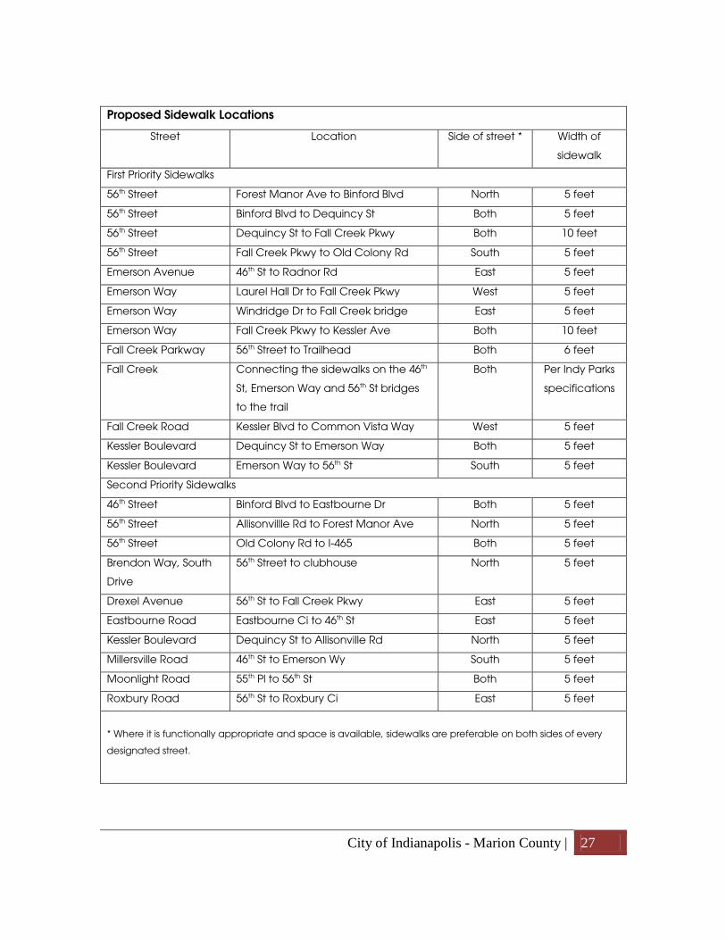
Sidewalk Locations
Proposed sidewalks are divided into first-priority and second-priority groups based on
distances from destinations and public input.
The locations of proposed sidewalks were based on the following list of criteria:
• Destinations - areas within 500 feet for first-priority sidewalks and 1000 feet for
second-priority sidewalks of the following destinations:
o park entrances and greenway trailheads,
o schools,
o churches,
o drugstores,
o office and retail centers,
o bus stops,
o apartment community entrances,
o major employers (10 employees or more)
• Places that currently have heavy vehicle traffic (traffic counts of 15,000 vehicles or
more per day).
• Missing links between existing sidewalks (a distance of 1000’ or less)
• Places that currently have heavy foot traffic.
• Available space in the right-of-way
City of Indianapolis - Marion County | 27
Proposed Sidewalk Locations
Street Location Side of street * Width of
sidewalk
First Priority Sidewalks
56th Street Forest Manor Ave to Binford Blvd North 5 feet
56th Street Binford Blvd to Dequincy St Both 5 feet
56th Street Dequincy St to Fall Creek Pkwy Both 10 feet
56th Street Fall Creek Pkwy to Old Colony Rd South 5 feet
Emerson Avenue 46th St to Radnor Rd East 5 feet
Emerson Way Laurel Hall Dr to Fall Creek Pkwy West 5 feet
Emerson Way Windridge Dr to Fall Creek bridge East 5 feet
Emerson Way Fall Creek Pkwy to Kessler Ave Both 10 feet
Fall Creek Parkway 56th Street to Trailhead Both 6 feet
Fall Creek Connecting the sidewalks on the 46th
St, Emerson Way and 56th St bridges
to the trail
Both Per Indy Parks
specifications
Fall Creek Road Kessler Blvd to Common Vista Way West 5 feet
Kessler Boulevard Dequincy St to Emerson Way Both 5 feet
Kessler Boulevard Emerson Way to 56th St South 5 feet
Second Priority Sidewalks
46th Street Binford Blvd to Eastbourne Dr Both 5 feet
56th Street Allisonvillle Rd to Forest Manor Ave North 5 feet
56th Street Old Colony Rd to I-465 Both 5 feet
Brendon Way, South
Drive
56th Street to clubhouse North 5 feet
Drexel Avenue 56th St to Fall Creek Pkwy East 5 feet
Eastbourne Road Eastbourne Ci to 46th St East 5 feet
Kessler Boulevard Dequincy St to Allisonville Rd North 5 feet
Millersville Road 46th St to Emerson Wy South 5 feet
Moonlight Road 55th Pl to 56th St Both 5 feet
Roxbury Road 56th St to Roxbury Ci East 5 feet
* Where it is functionally appropriate and space is available, sidewalks are preferable on both sides of every
designated street.

City of Indianapolis - Marion County | 28

City of Indianapolis - Marion County | 29
Crosswalk locations
The following list represents the top priority intersections for marked crosswalks as
determined by public input.
Crosswalks should follow the most direct and convenient pedestrian path. Marked
crosswalks must be a minimum of 6ft. wide and must connect to established sidewalks on
both ends. ADA accessible ramps shall be included at both ends of crosswalks
installations unless there are engineering reasons they cannot be provided. Designing
crosswalks with contrasting color and/or texture heightens their visibility and aids in
calming traffic.
Intersections recommended for marked crosswalks:
• 46th Street and Fall Creek Pkwy N. Drive
• 46th Street and Emerson Avenue
• Fall Creek Pkwy N. Drive and Alsuda Drive
• Fall Creek Pkwy N. Drive and Delmar
• Fall Creek Pkwy N. Drive and Drexel Avenue
• Fall Creek Pkwy N. Drive and Emerson Way
• Fall Creek Pkwy N. Drive and 56th Street
• Fall Creek Pkwy N. Drive and Kessler Boulevard
• Fall Creek Pkwy N. Drive and Chaminoix Lane
• Millersville Road and Laurel Circle
• Millersville Road and Emerson Way
• Emerson Way Mid-block between Fall Creek Pkwy N. Drive and 56th Street
• Emerson Way and Kessler Boulevard
• 56th Street and Allisonville Road
• 56th Street and Binford Boulevard
• 56th Street and Linwood Drive
• 56th Street and Emerson Avenue
• 56th Street Mid-block between Emerson Avenue and Kessler Boulevard
• 56th Street and Kessler Boulevard
• 56th Street and the entrance to Cathedral High School
• 56th Street and Roxbury Road
• 56th Street and Arlington Avenue
• 56th Street and Old Colony Road

City of Indianapolis - Marion County | 30
Bicycling
A Central Indiana Regional Bikeways Plan is being developed to establish priorities for
both regional and local bikeways through the year 2035. The plan’s goals are to
increase the number and safety of people riding bikes. The plan will score proposed bike
facilities against a list of criteria and give each proposal a funding priority. The
Indianapolis Regional Transportation Council (IRTC) has set a goal of directing 7% of the
region’s total transportation funding to bicycling and pedestrian facilities.
Three types of bikeways are proposed in the Regional Bikeways Plan: bike trails, bike
lanes and side paths. Bike trails are separated from traffic and are not located in a street
right-of-way. A bike lane is distinguished by pavement markings and signs for the specific
use of cyclists. For example, the bikeway on Allisonville Road is a pair of bike lanes. A
side path is much like a sidewalk in that it is separated from motor vehicle traffic and is
within a street right-of-way.
Currently, the City of Indianapolis has over 60 miles of on-street bike lanes. The
Indianapolis Office of Sustainability and Department of Public Works have worked
together on an Indy Bikeways Plan. This plan will create more than 200 miles of local bike
lanes throughout Indianapolis over the next 15 years.
Using local funds, bike lanes have been installed as part of resurfacing and sewer
projects. Bike lanes have also been completed through a Federal Transportation
Enhancement Grant.
Goals Policies, programs and projects
Actions
• Create a safe, convenient network of bikeways within the study area
• Connect bikeways within the study area to the regional network of bikeways
Provide bikeways as recommended in the following list.
• Work with the Office and Sustainability and the DPW Bicycle and Pedestrian Coordinator to establish local bikeways.
• Work with the MPO and IRTC to secure funding for connections to local bikeways.

City of Indianapolis - Marion County | 31

City of Indianapolis - Marion County | 32
• Provide secure and convenient bicycle parking
Locate bike parking at key destinations such as commercial and retail establishments. Parking should be well lit and in an area with street activity and active building fronts. Attention should be paid to the shape and design of the racks to maximize efficiency, usability and security.
• Include provision of bike parking in zoning and variance petitions.
The use of pervious pavement on bike paths and lanes would help alleviate drainage problems. Bicycle route signage should be provided at strategic locations. Recommended bikeways:
• A cross-county route south on Graham Road and Fall Creek Road, east on 56th
Street and then south on Arlington Avenue.
• 46th Street from Keystone Avenue to Shadeland Avenue
• 56th Street between Arlington Avenue and Old Colony Road
• 56th Street between Allisonville to the 56th Street bridge, as an alternative route to
62nd Street
• 62nd Street bikeway route from Allisonville Road to Kryghton Road to down to Fall
Creek Parkway North
• On-street bike lane running parallel to the Fall Creek trail
Recommended connections to regional bikeways:
• Bridging the gap between Fall Creek Greenway Trail between I-465 and Fort
Harrison State Park
Driving
Thoroughfares
Millersville at Fall Creek Valley is well-placed to take advantage of the city’s network of
thoroughfares. Interstate 465, which forms the eastern boundary of the project area, has
an interchange at 56th Street, and Binford Boulevard, an expressway, angles along the
western edge of the community. The city’s regular street grid starts to lose its
rectangularity as it hits Fall Creek causing Millersville to be a something of a hub where
56th Street, Kessler Boulevard, Fall Creek Road, Fall Creek Parkway and Emerson Way all
come together.

City of Indianapolis - Marion County | 33
Other important streets in the area are 46th Street, an east-west thoroughfare, and north-
south arterials Shadeland Avenue, Allisonville Road, Arlington Avenue and Sherman
Drive. The majority of the thoroughfares in the project area are in good condition; some
just need minor repair. However, much of Fall Creek Parkway’s pavement is
deteriorated.
The area’s thoroughfares move a lot of traffic efficiently and quickly; so quickly that
Emerson Way and 56th Street have reputations for over-the-limit speeds that often make
left-turns onto or off of these streets a problem.
The study area benefits from the attractive streetscapes to be found along many of its
thoroughfares where established homes, mature trees and a rolling topography add to
their visual quality. But factors such as frequent curb cuts, visual clutter from signs and
overhead utilities, poor street lighting, and a lack of pedestrian or bicycle amenities can
detract from the sense of place and make a street look undesirable and work against
new investment.
Local Streets
Local streets are generally found within residential areas. Frequently these streets were
installed by the original developer and, because of their light traffic, rarely needed
repair. However many of these streets in the Millersville area are now forty to sixty years
old and are nearing obsolescence. Pavement conditions and street drainage are
particular issues. Examples are Kessler View Drive and the section of Millersville Road
north of Fall Creek.

City of Indianapolis - Marion County | 34

City of Indianapolis - Marion County | 35
Goals Policies, programs and projects
Actions
• Improve traffic safety Conduct traffic studies to determine what physical or operational changes to the roadways are needed to improve safety. (see following list for recommended locations)*
• Work with the Department of Public Works to plan, fund and conduct traffic studies.
As pedestrian facilities are built, alert motorists to the increasing numbers of pedestrians
• Place articles in neighborhood newsletters.
• Install cautionary signs. • Increase traffic patrols
during the transition period.
Clear sight triangles clear of obstructing vegetation.
• Publicize the need for residents to report obstructing vegetation through the Mayor’s Action Center (327-4MAC).
• Repair local streets Conduct community-wide street condition surveys to determine top priority needs
• “Street and Alley” and “Sidewalk and Curb” survey forms are available for neighborhoods to use and then submit to the Department of Public Works.
* Examples of operational changes would be re-timing stoplights or restricting right turns on red lights in order to make street crossing safer for walkers and bikers.
Recommended traffic studies:
• 56th Street from Shadeland Avenue to Kessler Boulevard to reduce speeds,
provide safe turns onto and off the street, add landscaped medians, and
accommodate pedestrians and cyclists.
• 56th Street, Emerson Way and 46th Street bridges to add sidewalks, bike lanes and
railings.
• Emerson Way from Fall Creek to Laurel Hall to reduce speeds, provide safe turns
onto and off the street, add landscaped medians, and accommodate
pedestrians and cyclists.
• Fall Creek Parkway, North Drive from Emerson Way to 56th Street to widen and
improve the park space and reduce street and trail flooding.
• Streets in the Village area to reduce speeds, reduce pavement widths, improve
safety and convenience for pedestrians and cyclists, provide for mid-block

City of Indianapolis - Marion County | 36
pedestrian crossings, add landscaped medians, and use infrastructure for place-
making.
• Kessler Boulevard west of Binford Boulevard to improve traffic safety and
accommodate pedestrians and cyclists.
Physical measures to reduce the negative effect of motor vehicle use, alter driver
behavior and improve conditions for non-motorized street users is often referred to as
“Traffic Calming.” For more on traffic calming see Appendix C.
Mass Transit
Currently the study area is not served by a bus route (an express bus runs along the east
edge of the study area but does not stop). Lack of residential density and employment
density are primary reasons for the lack of bus service.
Although the overall density of the area is low, some spots do have a significant number
of potential transit users. In particular is the area on either side of 56th Street at the I-465
interchange where two large apartment communities are located.
The northeastern quadrant of metropolitan Indianapolis is currently being studied for a
rapid transit route that would connect downtown Indianapolis with destinations in
northeastern Indianapolis and extending north to the Town of Fishers and the City of
Noblesville. An Alternatives Analysis and an Environmental Impact Statement are
currently being conducted for the proposed line.
The proposed rapid transit line is likely to run west of the study area. If the opportunity for
mass transit in the northeast corridor develops, Millersville would benefit from an IndyGo
Bus route to close the gap between the study area and the rapid transit route. The
obvious routes to the west are 56th Street and Kessler Boulevard. However, adding an
east/west bus route to 56th Street/Kessler Boulevard is hampered by the physical
constraints of these roadways. 56th Street narrows considerably west of Emerson Way
and Kessler Boulevard is plagued by a narrow winding downhill section.

City of Indianapolis - Marion County | 37
Goals Policies, programs and projects
Actions
• Provide bus service to the apartment communities at 56th Street and I-465
Extend existing routes to serve this area.
• Work with IndyGo to study and fund a route extension.
• Connect the Millersville at Fall Creek Valley community to a proposed rapid transit line serving the northeast corridor.
Establish a bus route from the Millersville area to the most convenient station on the rapid transit route
• Work with IndyGo and the Metropolitan Planning Organization (MPO) to plan this route.
Fix deficiencies on 56th Street and/or Kessler Boulevard to accommodate a bus route
• Work with IndyGO and the Department of Public Works to determine the best solutions to these deficiencies.

City of Indianapolis - Marion County | 38
Plan Recommendations for Neighborhoods Neighborhood character
Myriad factors contribute to the character of a neighborhood, but broadly a
neighborhood’s character is its unique mix of place and people. Vibrant neighborhoods
are open to new ideas and evolving patterns of place and people. In the early
information-gathering phase of this planning process, a number of suggestions were
made for neighborhood projects and programs. The table below elaborates on some of
those ideas, but they should be seen only as a starting point or inspiration.
Among the suggestions issues that might inspire a neighborhood response are the often
interrelated issues of identity, sustainability, health and aging in place.
Because the Millersville at Fall Creek Valley area is a collection of neighborhoods, identity
can be a difficult, even emotional, issue. Building a Millersville at Fall Creek Valley brand
should be respectful of already-established neighborhood identities. The advantages of
creating an image or identity for the area are to build community involvement and
market the community to new residents and businesses. By developing a sense of
cohesion, the neighborhoods within the community can work together to build even
greater capacity to get things done. The Millersville at Fall Creek Valley organization has
already developed a logo, maintains a website and sponsors events and programs such
as a summertime market café, a series of outdoor concerts, and beautification projects
Sustainability, the community’s ability to meet its needs without compromising the ability
of future generations to meet their needs, is evident in many of this plan’s goals, policies,
projects, and programs. Neighbors can work together to increase the sustainability of
their neighborhoods. Some issues that are beyond the capacity of individual property
owners are perfectly scaled to be addressed at a neighborhood level.
Communities can be developed in ways that either promote or detract from public
health and retrofitting a neighborhood to better promote public health can be difficult
and costly. This area has community health advantages such as the Fall Creek
Greenway Trail and an extensive tree canopy. However it also has disadvantages. The
lack of sidewalks and social spaces discourages walking and public interaction.
Improvements are being made that will aid public health. Neighborhoods with septic

City of Indianapolis - Marion County | 39
tanks have recently been converted to sanitary sewers and bike routes are being
developed along some of the major streets. As with some sustainability issues, the
neighborhood can be an excellent scale at which to address some community health
issues.
The Millersville at Fall Creek Valley area has a higher percent of retirement-aged persons
than does Marion County as a whole (14% vs. 11%). Neighborhoods with a large
population of senior citizens are sometimes referred to as a NORC, a naturally occurring
retirement community. Various government and social service organizations have
studied and provide programming and services to NORCs in an effort to allow people to
age in place. Maintaining seniors in their homes and maintaining the homes of seniors
can be a big benefit to a neighborhood.
Goals Policies, programs and
projects Actions
• Develop a cohesive community identity
Build a consensus on a Millersville at Fall Creek Valley identity.
• Consult with the Indianapolis Neighborhood Resource Center to take advantage of their existing programs and expertise.
Develop consistent identifiers, such as gateway signage.
Sponsor events and programs
• Increase the sustainability of the neighborhood
Develop a neighborhood sustainability plan
• Determine which aspects of sustainability are neighborhood’s greatest concerns.
• Conduct a local "sustainability" assessment.
• Create a vision and action plan. • Develop sustainability indicators. • Identify sources of help. • Carry out projects. • Measure progress. • The City’s Office of Sustainability
and various programs within local colleges and universities are sources for information and expertise.

City of Indianapolis - Marion County | 40
Develop neighborhood-level storm water strategies.
• Consult with the Marion County Soil and Water Conservation District, Indianapolis Office of Sustainability and the Lower Fall Creek Watershed Alliance to take advantage of their existing programs and expertise.
Develop a neighborhood tree-planting or reforestation program.
• Consult with Keep Indianapolis Beautiful to take advantage of their existing programs and expertise.
Develop a neighborhood-level recycling program.
• Consult with Keep Indianapolis Beautiful to take advantage of their existing programs and expertise.
• Provide opportunities for healthy lifestyles
Provide a forum for the discussion of health issues.
• Consult with Health by Design or the Marion County Health Department to take advantage of their expertise.
• Increase the senior-friendliness of the neighborhood
Consult with senior organizations to take advantage of their existing programs.
• See list in Appendix E for a partial list of organizations.
Architectural heritage
The identity and history of an
area is often manifested in its
architecture. The bulk of the
homes in the study area were
constructed in the 1950s and
1960s, so they reflect the
dominant residential
architecture trends of the
time. The area’s architecture
can be used to create
awareness and appreciation of the neighborhoods.
Two of the most commonly found styles In the Millersville at Fall Creek Valley
neighborhoods are:
Mid-century Modern home.

City of Indianapolis - Marion County | 41
Modern: Typically flat-roofed or with shallow gables, they often incorporate wood, brick
and stone into the facades. The gabled forms often have wide eave overhangs and
exposed rafters. They are not bound to a particular shape and have little or no
decorative detailing.
Ranch: Low-pitched hip or side-gable roofs often with wide, boxed eaves are common.
The horizontality of the houses is emphasized by the shape, style and placement of
windows. They typically will present
a wide frontage to the street,
although the entrance is often
unobtrusive. Porches are rare.
Garages are often attached. They
are often minimally ornamented,
although it is not uncommon to see
them ornamented with elements of
earlier styles. In the study area
ranch homes with Colonial,
Georgian and French Provincial
detailing can be found.
The Indiana Division of Historic Preservation and Archaeology developed an inventory of
historic sites and structures for Lawrence Township in 1994 and for Washington Township in
1999. These inventories list sites and districts of historic
significance and rate them in ascending order of
significance as contributing, notable or outstanding.
Contributing structures (houses unless otherwise
noted)
3640 E. 46th Street, Double-pile, c. 1850 since
demolished
Millersville General Store, 5422 Millersville Road, 1870
5440 Millersville Road, Dutch Colonial Revival, c. 1910
Chapel, 5225 E. 56th Street, c. 1914
5660 Emerson Way, American Foursquare, c. 1925
3960 E. 58th Street, Cape Cod Colonial Revival, c.
1930
5740 Rolling Ridge Road, Colonial Revival, c. 1930
Ranch home.
5440 Millersville Road.

City of Indianapolis - Marion County | 42
Bridge, approximately 4600 Millersville Road, Concrete Arch, 1938
5010 Fall Creek Parkway, c. 1940
5020 Fall Creek Parkway, French Eclectic, c. 1940
5001 E. Kessler Boulevard, Ranch 1949
Notable structures (houses unless otherwise noted)
Joseph Ringer-Johnson House, 5580 Dequincy Street, I-House/Greek Revival, c. 1855
Winpenny House, 5504 Millersville Road, I-House, c. 1865
5714 Fall Creek Road, American Foursquare, c. 1910
Water Tower, 5220 Ladywood Drive, 1911, since demolished
Fletcher Bridge, 5225 E. 56th Street, c. 1915
Carriage House, 5225 E. 56th Street, c. 1915
Millersville Masonic Temple. 4990 E. Kessler Boulevard, Neo-classical, 1925
5220 Ladywood Drive, Colonial Revival, c. 1940, since demolished
Outstanding structures
Laurel Hall, 5395 Emerson Way, Jacobethan Revival, c. 1911
Loretto Hall, 5225 E. 56th Street, Tudor Revival, c. 1927
Carr-Roberts House, 3650 E. 46th Street, Tudor Revival, 1928
Historic district
Brendonwood, with 25 contributing structures, 21 notable structures and three
outstanding structures (the Walter C. Marmon House, 5610 E. 56th Street, c. 1920; the
Charles S. Lewis House, 6120 Old Orchard Road, 1923; and the Ralph V. Roberts House,
6350 Old Orchard Road, c. 1925)
Goals Policies, programs and projects Actions
• Use the area’s architectural heritage as an avenue to promote the area.
Create an inventory of mid-century modern structures.
• Consult with the organization Indiana Landmarks or the Ball State University’s historic preservation program for assistance in engaging an architectural historian to conduct the inventory.

City of Indianapolis - Marion County | 43
Nominate eligible structures and districts to the National Register of Historic Places
• To learn more, go to the National Park Service website at nps.gov/nr/about.htm or consult with the Indiana Division of Historic Preservation & Archeology
Call attention to the area’s architectural heritage through events such as home tours.
• Consult with the organization Indiana Landmarks for technical assistance in holding a home tour.
• Virtual home tours can be posted on line on neighborhood organization websites and on realtourvision.com and historichometours.com.
Create a walking or driving tour brochure.
• Consult with the organization Indiana Landmarks or the Ball State University’s historic preservation program for technical assistance.
• Use the area’s history as an avenue to promote the area.
Erect markers telling of the area’s history.*
• Consult with the Indiana Historical Bureau.
• Develop marker message and raise funds (approximately $2000) for the marker.
• Plan an unveiling ceremony to publicize the marker and the history it interprets.
• Apply to have the marker posted online at HMdb.org
Call attention to the area’s history through events such as a neighborhood history night or themed tour (like Irvington’s ghost tour).*
• Consult with the organization Indiana Landmarks and the history programs of local universities for recommendations for speakers.
Write a history of the area • Consult with Indiana University’s Center for the Study of History and Memory to develop an oral history project.
• Consult with the organization Indiana Landmarks and the history programs of local universities for suggestions of researchers/authors to develop a history of the area.
Use neighborhood events as an opportunity to promote the area’s history and architectural heritage
• Create a portable display that could be easily set up at community events.
* The 175th anniversary of the establishment of Millersville is in 2013. The centennial of Brendonwood is in 2017.

City of Indianapolis - Marion County | 44
Housing conditions
Although most of the homes in the study area are forty-plus years old, most are still in
excellent condition or need only superficial repairs. However a survey of the exterior
conditions found one area with a significant concentration of homes in poor condition:
the area between Binford Boulevard and Fall Creek Parkway on either side of 46th Street.
This area has 43 single-family structures of which 58% are owner-occupied. The
conditions of these houses were rated as follows:
• Excellent: 16%
• Superficial repairs needed: 44%
• Minor deterioration: 25%
• Major deterioration: 16%
No owner holds more than one home in the neighborhood, so no single owner or small
group of owners dominates property ownership. There were three apparently vacant
homes in the neighborhood at the time of the survey and all three exhibit major
deterioration.
As the condition of homes improves, the correlation with owner-occupancy gets
stronger.
Condition Percent of Owner-occupied
houses
Percent of Non-owner-
occupied houses
Excellent 20% 11%
Superficial repairs needed 40% 44%
Minor deterioration 24% 28%
Major deterioration 16% 17%
Deteriorated homes can create a downward spiral of disinvestment and ever poorer
housing conditions. The area described above is relatively isolated from the rest of the
study area, so it is probably not creating a negative impact directly on a wide area.
However deteriorated homes are concern wherever they may occur.

City of Indianapolis - Marion County | 45
Goals Policies, programs and projects
Actions
• Repair or demolition of deteriorated structures
Continued action by the Marion County Health Department to cause property owners to repair or demolish deteriorated structures.
• Publicize the need for residents to report deteriorated structures to the Marion County Health Department’s Housing and Neighborhood Health section (221-2150)
Work with the Land Bank to develop a neighborhood strategy for abandoned homes.
• Tax delinquent properties that have been through a County tax sale and not sold can be transferred to the City’s Land Bank, which in turn can transfer them to entities that will repair or demolish and rebuild them
Create a neighborhood work group to hold events to do home repair for willing homeowners.
• Consult with Indianapolis Neighborhood Resource Center or SouthEast Neighborhood Development for ideas in setting up an event.
Crime and security
The Indianapolis Metropolitan Police Department (IMPD) has characterized the study
area as safe, but not crime free. The most commonly reported crime is theft (taking
someone else’s property) followed by burglary (entering a structure with the intent to
commit a felony). In the first half of 2011 seventeen crimes against persons were
reported, which is low for an area this large, but still a concern.

City of Indianapolis - Marion County | 46
Goals Policies, programs and projects
Actions
• Reduced crime and a safer neighborhood
Take advantage of information and programs provided by IMPD.
• Arrange for IMPD Community resource officers to attend neighborhood association meetings.
• Contact IMPD for information on forming Crime Watches.
• Arrange with IMPD to conduct CPTED surveys.*
Publicize crime prevention information.
• Use neighborhood newsletters neighborhood association events as venues for disseminating information.
* CPTED (Crime Prevention through Environmental Design), employs physical design features that discourage crime, while at the same time encouraging legitimate use of the environment. It has been shown to greatly reduce crime in targeted areas in other cities. See Appendix D.
Nuisance violations
Nuisance violations refer to violations of City health and property maintenance codes
such as high weeds and grass, abandoned and unsafe buildings, accumulation of trash
on private property, and inoperable vehicles. These types of violations detract from the
overall character of a neighborhood and contribute to neighborhood decline. Based
on 2009 data, the number of nuisance violations in the study area is low. The only
exception to this is the area south of 46th Street between Binford Boulevard and Fall
Creek Parkway.
In a survey of participants in this planning process, trash was the nuisance violation of
greatest concern. Trash was also the most common type of nuisance abatement case
in the study area in 2009 with 88 violations.
The City can tow vehicles that are left standing on any street or public place in violation
of City or State code, as well as any stolen or wrecked vehicle on a street or public
place. Vehicles can also be towed from private property if the property is not zoned for
the storage of inoperable vehicles and if the vehicle is at least three model years old,

City of Indianapolis - Marion County | 47
mechanically inoperable and visible from public property for more than 20 days or left
for more than 48 hours on private property with the property owner’s consent.
Goals Policies, programs and projects
Actions
• Prompt removal of trash from private property.
Continued action by the Marion County Health Department to cause the removal of trash from private property.
• Publicize the need for residents to report trash accumulating on private property to the Marion County Health Department’s Housing and Neighborhood Health section (221-2150).
• Prompt removal of illegally dumped trash on public property.
Continued action by the City’s Department of Code Enforcement to remove trash on public property.
• Publicize the need for residents to dumping of trash on public property through the Mayor’s Action Center (327-4MAC).
• Prompt removal of inoperable vehicles.
Continued action by the City’s Department of Code Enforcement to remove abandoned or inoperable vehicles from private property or public rights-of-way.
• Publicize the need for residents to report abandoned and inoperable vehicles to the Mayor’s Action Center (327-4MAC).
• Prompt abatement of high weeds and grass.
Continued action by the City’s Department of Code Enforcement to cause the abatement of high weeds and grass.
• Publicize the need for residents to report high weeds and grass to the Mayor’s Action Center (327-4MAC).

City of Indianapolis - Marion County | 48
Plan Recommendations for the Village of Millersville
Millersville is the neighborhood commercial hub that serves the study area. It consists of
the area defined by the curve of Fall Creek in proximity to the meeting of a number of
arterial streets: Kessler Boulevard, 56th Street, Emerson Way, Fall Creek Road and Fall
Creek Parkway. Primarily a retail area interspersed with offices, an assisted living facility
and a Masonic Lodge, Millersville is generally surrounded by condominiums and large-lot
single-family homes.
Through the planning process the following set of development principles was defined to
describe the ideals and goals for redevelopment in the Millersville area.
Neighborhood-level retail and office needs are fully served.
By providing a full range of neighborhood level services, Millersville will not give local
residents a reason to go elsewhere for their day-to-day needs. Community and
regional level services typically are more intense in terms of traffic and activity and
are typically larger in size. These uses should be kept to a minimum to
accommodate the neighborhood uses and the physical scale of the area.
Businesses are well-connected physically and visually.
A group of businesses in proximity to each other does not make a business
community. It takes interpersonal connections to create mutual support. The
physical lay-out of the area should support and encourage interpersonal
connections by providing views from business to business, buildings that don’t
needlessly turn their back to each other and sites with integrated access.
The business area is pedestrian friendly.
Design of the streets, sidewalks and crosswalks, as well as traffic patterns and speeds
should create safe and convenient interaction between pedestrians and vehicles.
Safe pedestrian connections from the surrounding institutions and neighborhoods will
bring customers into the retail area. Providing safe, convenient pedestrian
connections within the retail area will encourage customers to spend more time and
visit more businesses.

City of Indianapolis - Marion County | 49
The business area is well-connected to Fall Creek Trail.
The Fall Creek Greenway Trail is an asset for the Millersville retail area. The trail is a
conduit for both residents from the surrounding neighborhoods and people from
outside the neighborhood who are using the trail for recreation. Creating easy
connections between the retail area and the trail will encourage trail-users to be
customers.
The streetscape is attractive, practical and reinforces the identity of the area.
The streetscape provides an opportunity to express the identity of the area through
the use of materials, landscaping, lighting, signage and other elements. Plant
materials soften the harshness of the modern urban environment. Installing trees and
plants will contribute to an overall sense of community and bring aesthetic and
economic benefits by creating a perception that an area is comfortable, high-
quality and well taken care of. A convenient, safe, and easily understood
streetscape will ensure that drivers and pedestrians can see where they are going
and feel welcomed to the area.
Historic buildings are preserved.
Millersville has a physical heritage that few commercial areas in the City have.
Retaining and accentuating its historic fabric will differentiate the area and aid in its
marketing.
Outdoor social spaces are provided.
Neighborhood retail centers provide places where neighbors can randomly and
informally meet. The expectation that one might run into friends and neighbors
becomes a reason to patronize the area. Providing for outdoor social spaces such as
sidewalks, benches, patios, and outdoor dining will strengthen the social aspects of
the area.
Market
Although the village dates back to 1838, its development as a modern commercial area
dates to the 1970s. Toward the end of the first decade of the 21st century the area was
starting to show signs of disinvestment as two major retail tenants in the area shut their

City of Indianapolis - Marion County | 50
doors. However the market for goods and services in the area appears to be good, so
revitalization of the area would appear to have an excellent chance of success.
The demand for goods is driven in part by the demographics of the service area. The
2010 census population for the study area is 10,553 persons in 4,858 households. The
Millersville at Fall Creek Valley study area is more racially diverse, better educated, older,
and has higher household incomes than Marion County as a whole. The area also has a
higher income per acre than Marion County as a whole.
Race, Hispanic origin (2010 Census) Education attainment (2009 Census
estimate)
White 43.5% Not a high school
graduate 8.7%
African-American
50.6%
High graduate 23.0%
Native American 0.2% Some college 22.7%
Asian 1.1%
Associate degree 6.3%
Other 2.0%
Bachelor degree 23.7%
Multi-racial 2.7%
Masters degree 11.6%
Hispanic 4.3% Professional school
degree 3.1%
Doctorate degree 0.9%
Household income (2010 Census, income for the year 2009)
Income (2010 Census, income for the year 2009)
Less than $15,000 5.5% Median household income $60,817
15,000 to 24,999 8.7%
Income per acre $100,284
25,000 to 49,999 26.6%
50,000 to 74,999 22.2%
Age (2010 Census)
75,000 to 99,999 16.2%
17 years or less 21.9%
100,000 to 199,999 15.5% 18-64 62.9%
$200,000+ 5.1% 65 years or more 15.2%

City of Indianapolis - Marion County | 51
A private information company’s software was used to develop a retail marketplace
profile for the study area. Based on this company’s analysis of the study area, the study
area has a higher than average demand for most goods and services. This information
was then compared to the retail sales in the area. The comparisons were used to
determine leakage and surplus. Leakage is the amount of the area’s demand for a type
of retailer that is being satisfied outside the study area. Surplus is the amount of sales for
a type of retailer within the study area that is coming from customers who live outside the
study area.
The types of retailers with the greatest leakage in the Millersville at Fall Creek Valley area
are:
1. Department stores
2. Furniture stores
3. Motor vehicle dealers other than dealers of automobiles, light trucks, SUVs and
passenger vans
4. Jewelry, luggage and leather goods stores
5. Shoe stores
6. Sporting goods, hobby and musical instrument stores
7. Lawn and garden equipment and supplies stores
8. Automotive dealers (automobiles, light trucks, SUVs and passenger vans)
Many of these retailer types are regional in their draw and would not be found in each
neighborhood.
The study was developed from 2006 and 2007 data, a time when the grocery at the
Windridge Shops was still in operation, which may skew the results.
Traffic counts are another factor is the location decisions of retailers. Traffic counts
through the Millersville area are generally favorable. (see map on page 28) The Fall
Creek Greenway Trail brings pedestrians and bicyclists to Millersville. Trail counts are
highly weather dependent, but range from 400 a month in harsh winter weather to over
8000 a month in pleasant summer weather. (see chart on page 6)

City of Indianapolis - Marion County | 52
Although there may be a large enough market in the Millersville area to sustain the
village’s retailers, a lack of identity and marketing may be allowing potential customers
to slip away.
The Millersville at Fall Creek Valley organization has made a start at establishing an
identity for the area through beautification projects, creation of a logo and
maintenance of a website. The group has also started to market the area through
events such as a summer concert series and weekly market café evenings during the
summer. Also, a businesspersons group has been formed and has started to meet.
Goals Policies, programs and
projects
Actions
• Strengthen the village’s customer base
Establish an authentic identity or brand, possibly with the help of marketing professionals.
• Develop a marketing group within the businesspersons association.
Conduct events and programs that will attract customers.
• Create an attractive shopping and business environment
Develop a façade improvement program.
• Consult with the City’s divisions of Community and Economic Development for assistance in establishing these programs.
Create a Business Improvement District. *
Create a form-based village zoning district
• Work with property owners in the village to establish a consensus on creating the district.
• Using the framework set out in the zoning section, pages 57 to 67, work with the City’s Division of Planning to create a regulating plan.
• Adoption of the district requires action by both the Metropolitan Development Commission and the City-County Council.
* A BID is typically formed by a group of property owners in a geographically defined area to fund supplemental governmental services (e.g. cleaning and maintenance), non-governmental services (e.g. landscaping, marketing and promotion), and capital investments (e.g. sidewalk widening). The municipality in which a BID is located collects the BID's supplemental property tax assessments through its general taxation powers and distributes them to the BID. A board of directors composed of property owners, merchants, residents and public sector representatives is then given authority by the government to undertake projects and programs within the district.

City of Indianapolis - Marion County | 53
Street and Traffic patterns
(Recommendations pertaining to connectivity within the village area may be found in
the “Recommendations for Connectivity” section.)
The width and configuration of the streets within the village have an effect on drivers,
pedestrians and the businesses that serve them. In order to balance the needs of these
groups the work group recommended modifications to the streets in the village that will
maintain traffic volume while reducing speeds, increasing pedestrian safety and
convenience, and providing a sense of place.
Emerson Way between Fall Creek Parkway and 56th Street varies in width from six to
seven lanes. This includes two north-bound through lanes, two south-bound through
lanes, a center turn lane, a south-bound right-turn lane and in some locations a north-
bound right-turn lane. This many lanes of traffic are daunting to pedestrians and
probably excessive for the volume of traffic on this street segment. This segment should
be studied by traffic engineers for the possibility of reducing the number of lanes and the
addition of a mid-block pedestrian crossing. Some likely modifications would be the
reduction in length of the right-turn lanes and the addition of medians to the center turn
lane. The addition of curbs, gutters, sidewalks and bike lanes would help direct and
control traffic, pedestrians and storm water run-off.
As 56th Street approaches the village of Millersville from the west it increases in width from
two lanes to four through lanes plus a turn lane. Turning traffic is controlled by raised
medians. Although less wide than Emerson Way, 56th Street is not as pedestrian friendly
as it could be. 56th Street should be studied by traffic engineers for the possibility of
reducing the length of the turn lanes and the addition of a mid-block pedestrian
crossing. The addition of curbs, gutters, sidewalks and bike lanes would help direct and
control traffic, pedestrians and storm water run-off. The 56th Street Bridge should also be
studied to determine the best way to get pedestrians across Fall Creek, in particular
students from Cathedral High School who currently walk across the bridge despite less
than ideal conditions.
The addition of pedestrian crosswalks at all major intersections within the village is
recommended. Mid-block pedestrian crossing should be well-lit for added safety.
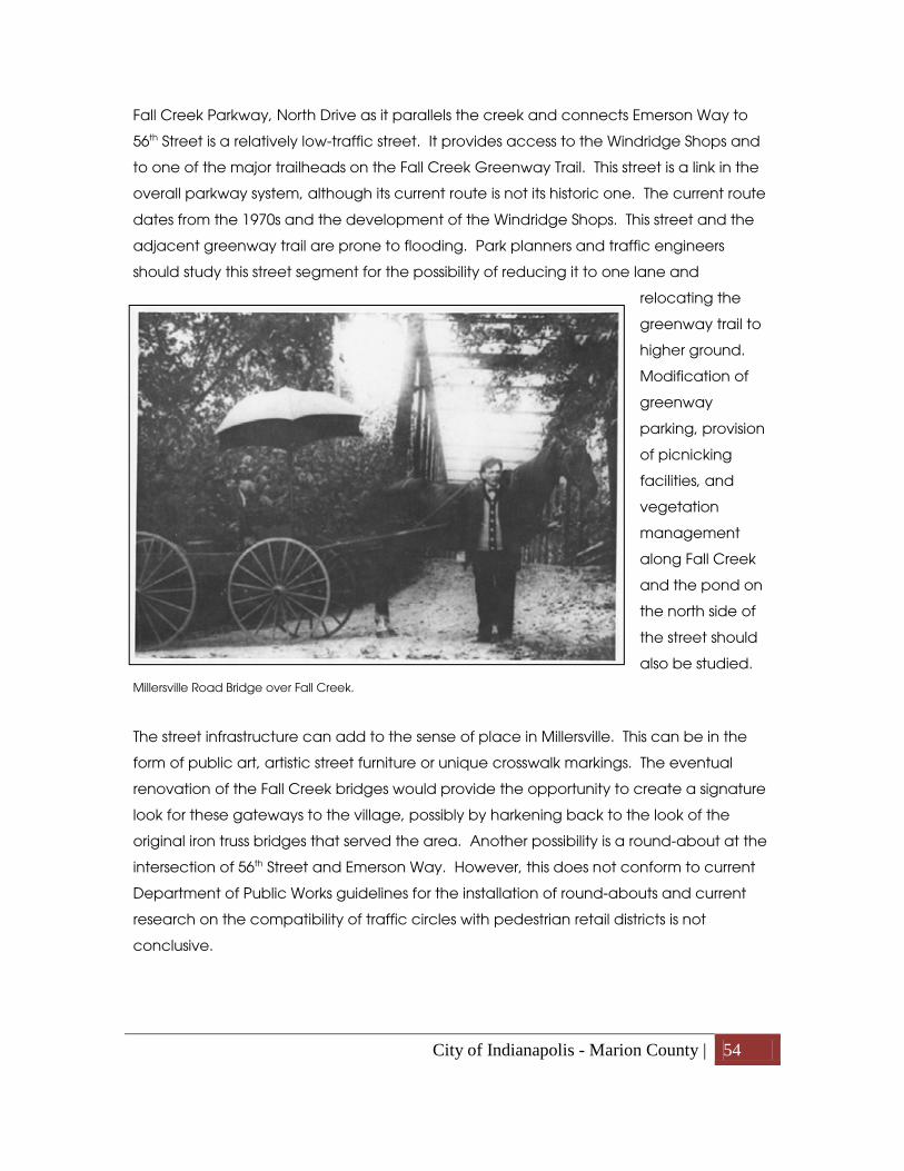
City of Indianapolis - Marion County | 54
Fall Creek Parkway, North Drive as it parallels the creek and connects Emerson Way to
56th Street is a relatively low-traffic street. It provides access to the Windridge Shops and
to one of the major trailheads on the Fall Creek Greenway Trail. This street is a link in the
overall parkway system, although its current route is not its historic one. The current route
dates from the 1970s and the development of the Windridge Shops. This street and the
adjacent greenway trail are prone to flooding. Park planners and traffic engineers
should study this street segment for the possibility of reducing it to one lane and
relocating the
greenway trail to
higher ground.
Modification of
greenway
parking, provision
of picnicking
facilities, and
vegetation
management
along Fall Creek
and the pond on
the north side of
the street should
also be studied.
Millersville Road Bridge over Fall Creek.
The street infrastructure can add to the sense of place in Millersville. This can be in the
form of public art, artistic street furniture or unique crosswalk markings. The eventual
renovation of the Fall Creek bridges would provide the opportunity to create a signature
look for these gateways to the village, possibly by harkening back to the look of the
original iron truss bridges that served the area. Another possibility is a round-about at the
intersection of 56th Street and Emerson Way. However, this does not conform to current
Department of Public Works guidelines for the installation of round-abouts and current
research on the compatibility of traffic circles with pedestrian retail districts is not
conclusive.

City of Indianapolis - Marion County | 55
Land Use In this plan the topic of land use is treated as a grouping of four components:
environmentally sensitive areas, land use recommendations, critical areas and zoning
recommendations.
Environmentally Sensitive Areas
Environmental factors should be taken into consideration and have a modifying effect
on any development or redevelopment of a site with those conditions. This plan includes
an Environmentally Sensitive Areas map that depicts five environmental factors:
wetlands, floodplains, steep slopes, woodlands and wellfields. The Millersville study area
exhibits all five of these factors.
Wetlands. This factor is based on mapping provided by the Indiana Department of
Natural Resources.
Floodplains. These are areas where floodwater is likely to stand during a flood of such
intensity that it is likely to happen once in 100 years. Mapping is based on 2001 Federal
Emergency Management Agency flood panels.
Natural Woodlands. These are groupings of trees, naturally occurring or planted.
High Quality Woodlands. Older woodlands tend to have greater biodiversity than
younger ones, so these woodlands should particularly have a modifying effect on new
development. Based on 1999 data, the mapping of this factor depicts woodlands that
have been relatively undisturbed for over 50 years.
Steep slopes. Based on 2003 data, these are slopes with greater than one foot of rise in
elevation over 10 feet of horizontal distance. The Millersville area is distinctive in Marion
County for its steep, ravine-cut bluffs overlooking the Fall Creek valley.
Wellfields. Wellfields are part of the larger aquifers, porous underground water-bearing
strata, which lie under Marion County. Most of Indianapolis’s drinking water comes from
surface sources such as White River and Fall Creek. However while the supply of surface

City of Indianapolis - Marion County | 56
water remains the same, the demand for water is increasing, so a growing proportion of
the County’s drinking water is being taken from the groundwater by wells.
Two wellfields overlap the Millersville at Fall Creek Valley study area. The Richardt
Wellfield extends from Fall Creek south to roughly 52nd Street and from approximately
Mark Lane eastwards out of the study area. The Fall Creek Wellfield covers the portion of
the study area roughly west of Sherman Drive and south of Lorraine Road.
A safe, efficient groundwater supply system requires monitoring, treatment and
prevention of contamination. To protect the underground drinking water supply, the
Wellfield Protection Zoning Ordinance was adopted in 1997. This ordinance created
Wellfield Protection Zoning Districts that are delineated by the time a drop of water takes
to travel from the ground’s surface through the ground to a well intake. The districts are
divided into W-1 (one year time of travel) and W-5 (five year time of travel) zones. The
ordinance provides for additional review of permits for businesses that wish to locate in
wellfields and that use products that may contaminate the groundwater. These
businesses are typically asked to make accommodations for the potential spills of
contaminants.

City of Indianapolis - Marion County | 57

City of Indianapolis - Marion County | 58
Land Use Recommendations
The map of recommended land uses is a guide for property owners, neighbors and
neighborhood associations, City staff, the Metropolitan Development Commission and
Boards of Zoning Appeals when considering proposed development projects.
The map recommends one of 15 land use categories for each parcel (see Appendix F for
descriptions of the land use categories). The land use categories broadly define
development by use and intensity, and should be considered the most appropriate use
for the land. They are the starting point for determining the appropriateness of land use
requests such as zoning and variance of use petitions.
The Millersville at Fall Creek Valley area is largely developed and the existing land uses
are generally stable. To bolster the area’s stability the Land Use recommendation for
most parcels in the study area is the same as its existing land use.
Village of Millersville
The retail area at 56th Street and Emerson Way is designated as “Village Mixed-Use” to
promote the evolution of this area into a pedestrian-oriented village.
Currently, much of the commercial development in Millersville is in the form of small to
medium-sized, stand-alone or multi-tenant buildings. Notable exceptions to this are the
Windridge Shops and Emerson Plaza. The Windridge Shops is an L-shaped shopping
center that faces Fall Creek Parkway across a large parking lot and retention pond. It
was originally anchored by a grocery store and has a mix of small and medium tenant
bays. Between the retail shops and Emerson Way is a five-story office building with
Marine Bank as its main tenant. Emerson Plaza was also originally anchored by a grocery
store. It faces Emerson Way at an angle. Its parking is primarily between the front of the
building and Emerson Way. Immediately behind the center is a short segment of
Millersville Road.
The land use category designated for Millersville is Village Mixed-Use. This category
recommends a mix of retail, office and residential uses built to a pedestrian scale. Village
mixed use areas are intended to be neighborhood gathering places and should allow a
wide range of small businesses, housing types, and public and semi-public facilities.

City of Indianapolis - Marion County | 59
Potential development in these areas should focus on design issues related to
architecture, building size, parking, landscaping and lighting to promote a pedestrian-
oriented “village” or “small town” atmosphere. Typical strip commercial development,
large-scale freestanding retail uses and heavy industrial development are generally
inappropriate within this land use category.
Commercial development in the Millersville vicinity should be contained to the village
retail area and not allowed to encroach into the surrounding, established residential
areas or along Fall Creek Parkway, 56th Street, Emerson Way or Kessler Boulevard.
Critical Areas Critical Areas are locations that exhibit an unusual character, important location or
significant need that warrants more explanation and detail than the land use
recommendation on the map can provide. The Critical Area text explains why a
location is critical and how development in those areas should accommodate those
critical factors.
Critical Area 1
Location: 56th Street west of Binford Boulevard
Why Critical: The parcels at 3940 and 4055 East 56th Street are zoned and/or developed
in ways that are anomalous to their vicinity. It is critical that future development or
redevelopment of these sites is compatible with their surroundings.
3940 East 56th Street was developed in the early to mid 1970s with a nursing home and an
apartment building. The structures were the first phase of a larger residential and
commercial project that was never completed. The western portion of the 7.2 acres site
remains open for development. A 2010 rezoning to C2 allows for both office and multi-
family residential uses of up to ten units per acre. The case, 2010-ZON-052, set a building
height limitation of 35 feet, set a limit on the total square feet of gross leasable office
space at 36,000, set restrictions on signage and lighting and required a tree preservation
plan. These commitments were requested to protect the surrounding neighborhood
from the development of a large office center with one or more towers and expanses of
parking, while allowing for small-scale offices, day care, assisted living, and other
medical and adult care facilities.

City of Indianapolis - Marion County | 60
4055 East 56th Street was developed in late 00s with mini-warehouses. Under Indianapolis
zoning, mini-warehouses are a heavy commercial or light industrial use. The surrounding
residential and institutional land uses make this site unsuitable as a retail commercial
node or industrial site. Should the mini-warehouses leave, this site is not appropriate for
another heavy commercial or light industrial use.
Neither site should be developed for retail uses because such development would
diminish the commercial vitality of nearby, established commercial nodes such as the
village of Millersville.
Recommendations:
• Small-scale office development is recommended for the northern site (3940 East 56th
Street), but should be kept low in height (less than 35 feet), limited in gross leasable
office space, well-buffered from surrounding residential uses and free from large
expanses of parking. Future development or redevelopment of this site for residential
purposes may be appropriate if kept under a density of ten units per acre, is kept low
in height (less than 35 feet), well-buffered from surrounding residential uses and free
from large expanses of parking. No development should take place within or to the
north of the drainage easement. This recommendation takes into account the
residential character of the locale, nearby Binford Boulevard and the densities of the
surrounding developments.
• Future redevelopment of the southern site (4055 E. 56th St.) for residential purposes
should be kept under a density of eight units per acre, low in height, well-buffered
from surrounding residential uses and free from large expanses of parking. This
recommendation takes into account the residential character of the locale, the
adjacency of Binford Boulevard and the densities of the surrounding developments.
• Existing trees should be preserved to the extent possible.
Critical Area 2
Location: 46th Street and Fall Creek Parkway
Why Critical: This plan recommends redevelopment of the area between Fall Creek
Parkway and Binford Boulevard on the south side of 46th Street from a single-family district
to a higher density single-family or multi-family neighborhood.
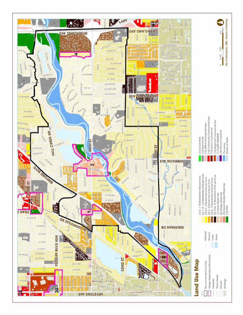
City of Indianapolis - Marion County | 61

City of Indianapolis - Marion County | 62
Recommendations:
• Conversion of the single-family residential parcels to multi-family development should
not be done in a piecemeal manner, but in groupings of contiguous parcels. The
purpose of this is so homes are not isolated among the multi-family structures.
• Existing trees should be preserved to the extent possible.
Critical Area 3
Location: Village of Millersville (vicinity of 56th Street and Emerson Way)
Why critical: The commercial uses in this area were not developed in a coordinated
manner and do not physically relate well to each other, or in some cases, to the high-
traffic streets in the area. Much of the commercial development is dated-looking and
show signs of disinvestment, although the market for goods and services in the area
appears to be good. Remnants of the historic town of Millersville still exist in this area.
Millersville is designated as “Village Mixed-Use” to promote the evolution of this area into
a pedestrian-oriented village
Recommendations:
• For development principles that describe the ideals and goals for redevelopment
in the Millersville area see pages 48-50.
• For land use recommendations for the village area see page 58.
• For development guidelines for the village area see pages 68 to 82.
Critical Area 4
Location: North of 56th Street, east of Brendon Forest Drive, south of Fall Creek
Why Critical: Brendon Forest Drive is a meandering, low traffic street. An approximately
21-acre site is located along most of the east side of the street. The remainder of the
street’s frontage is developed with single-family lots ranging in size from one-half to five
acres. The Critical Area is a transitional zone with Woollens Garden, a City-owned, State-
designated nature preserve to the north; Brendonwood, a historic, low-density
neighborhood to the west; a large apartment community to the east; and 56th Street, a
high-volume arterial street to the south. The I-465/56th Street interchange is nearby.
Development in this area should act as a buffer between the higher density residential to
the east and the lower density residential to the west. It is critical to provide an

City of Indianapolis - Marion County | 63
appropriate transitional density for this area that is compatible with surrounding land
uses. High-quality woodlands and slopes greater than 10% found on the northern portion
of the parcel should be protected from overdevelopment.
Recommendations:
• Do not allow any retail development to occur on this parcel.
• The land use recommendation for this parcel is 1.75 – 3.5 units per acre.
Development of the parcel should allow for a higher density clustered residential
development at the south end of the parcel balanced by lower density residential
development at the north end in order to protect the steep slopes and woodland on
the northern end of the site. A total density of 1.75 to 3.5 units per acre, and
preferably 1.75 – 2.5 units per acre, should not be exceeded.
• A significant amount of high-quality and natural woodlands occurs on the northern
edge of the Critical Area. Conservation of the oldest and highest quality portions of
the woodlands is of particular importance. Development within this area should
provide substantial conservation of the tree canopy.
• Tree lines on the perimeter of the site should be conserved to the extent possible.
• A dense screen of trees and shrubs has been established on the multi-family
residential property to the east; this screen should be maintained as buffer between
the multi-family residential development and the single-family neighborhoods to the
west. Augmentation of the screen with evergreen trees and shrubs is recommended
to create a more all-season screening.
• Structures on this site should be compatible with the homes on the west side of
Brendon Forest Drive in height, size, building forms, and materials.
• Development of this site will likely require upgrading of infrastructure, which may
include drainage, sanitary sewers and streets. Development of this site should not
exacerbate any deficiencies in storm water and sanitary sewers that may exist along
Brendon Forest Drive, and ideally should provide an opportunity to improve storm
water and sanitary sewer service.
• Dense vegetative cover along stream banks is important for erosion control,
contaminant capture, water cooling (critical for retaining oxygen levels) and habitat
preservation.
• In places, steep slopes define the edges of a stream valley. These slopes should be
minimally developed, if at all, so that they may retain their forest cover and avoid soil
erosion.

City of Indianapolis - Marion County | 64
• Development within proximity of Woollens Gardens should also be mindful of soil
erosion and possible contamination of Fall Creek’s water.

City of Indianapolis - Marion County | 65

City of Indianapolis - Marion County | 66
Zoning Indianapolis employs zoning as a method to provide for orderly development.
A recommended zoning map (page 85) has been developed for the village area
because specific zoning districts are being recommended as the optimal way to
implement the land use recommendations made above.
A zoning plan has not been developed for the area outside the village area. Here the
land use categories, as recommended above, can typically be implemented through
more than one zoning district.
Indianapolis, like most jurisdictions that practice zoning, uses a form of Euclidean zoning.
Named for Euclid, Ohio, the foundation of this form of zoning is the separation of
incompatible land uses. It is common for Euclidean zoning codes to also include
development standards for such items as setbacks, parking, building heights and dozens
of other aspects of site and building development. Euclidean zoning came of age in the
automobile era and so Euclidean codes are usually car-centric.
Another type of zoning, called form-based zoning, is based less on the separation of uses
and more on how buildings relate to their sites and the street. Form-based zoning and
hybrid Euclidean/form-based codes are being adopted in an increasing number of
jurisdictions.
The regulations and standards in form-based codes, presented in both diagrams and
words, are keyed to a regulating plan that designates the appropriate form and scale
(and therefore, character) of development. Not to be confused with design guidelines or
general statements of policy, form-based codes are regulatory, not advisory.
Form-based codes commonly include the following elements:
• Regulating Plan. A plan or map of the regulated area designating the locations
where different building form standards apply. The regulating plan is based on
clear community intentions regarding the physical character of the area. The
regulating plan may also include additional on-site development standards
• Public Space Standards. Specifications for the elements within the public realm
(e.g., sidewalks, travel lanes, on-street parking, street trees, street furniture, etc.).

City of Indianapolis - Marion County | 67
• Building Form Standards. Regulations controlling the configuration, features, and
functions of buildings that define and shape the public realm.
As a recognizable village with a mix of uses, Millersville has great potential for the
successful application of form-based zoning. Most of the village is recommended for the
Neighborhood-Village or NV zoning district as the best way to implement form-based
zoning.
Visual preference survey
A visual preference survey was conducted at meetings in January and February 2011 to
help determine what design elements were most important to the users of the village
area. Participants were shown 41 slides of various design elements in a variety of
streetscapes. They were asked to rate the photos on a seven-point scale from negative
to neutral to positive.
The elements that were most strongly preferred were:
• Curbed streets with sidewalks
• Landscape beds with simple, curvilinear designs
• Moderate to narrow building set-backs
• An activity zone (e.g. benches, dining, gathering areas) between buildings and
street
The photos that were most negatively rated tended to show:
• Poor maintenance
• Uncurbed streets
• Extensive front parking lots

City of Indianapolis - Marion County | 68
Examples of highly rated photos from the visual preference survey
Examples of photos that rated poorly in the visual preference survey
Street typologies and design elements
As a method to implement many of the development principles, design elements are
recommended for the village. These design elements can be used as guidelines for the
review of future zoning and variance petitions or can form a vision plan for the eventual
development of form-based zoning.
Although a small area, the streets in the village vary in how they look and function. The
streets were analyzed and then each one was classified into one of four typologies.
Suburban commercial street:
The Suburban commercial street type is intended to balance the need for a safe, active,
diverse and pedestrian-scaled area with the need for convenient automobile access.

City of Indianapolis - Marion County | 69
A: Medium intensity
The Medium intensity suburban commercial street type is intended to be a commercial
hub for the surrounding neighborhoods. Ideally it is buffered from residential districts by
lower intensity street types, so that it may have more intense development without
having negative impact on single-family residential areas. 56th Street between Emerson
Way and Kessler Boulevard is classified as a Medium intensity suburban commercial
street, as is Emerson Way between Fall Creek Parkway and 56th Street.
B. Low intensity
The Low intensity suburban commercial street type is intended to ensure that new
development contributes positively to established residential neighborhoods and
character, and improves the transition between more intense commercial development
and adjacent residential neighborhoods. 56th Street between DeQuincy Street and
Emerson Way is classified as a Low intensity suburban commercial street as is Emerson
Way for approximately 400 feet north of 56th Street center line.
Traditional parkway:
The Traditional parkway street type is intended to be a curvilinear pleasure drive with a
continuous parkspace on one side. The other side of the parkway should complement
the parkspace. Fall Creek Parkway from DeQuincy Street to 56th Street is classified as a
Traditional parkway.
Village lane:
The Village lane street type is intended to preserve and enhance the character of the
historic town of Millersville’s last remaining street. It is intended to be low-speed, low-
traffic and pedestrian-oriented. The portion of Millersville Road north of Fall Creek is
classified as a Village lane.

City of Indianapolis - Marion County | 70

City of Indianapolis - Marion County | 71
Redevelopment along these street segments should be guided by the following
recommendations for the following design elements:
• Setbacks
• Streetscapes
• Pedestrian Connections
• Building orientation
• Building height
• Fenestration/transparency
• Roofline
• Parking
• Signage
• Lighting
Set-backs, minimum and maximum
The minimum and maximum set-backs control the placement of buildings in relationship
to the street. It contributes to the coherence of the urban fabric, creating greater whole
out of the individual buildings. It reinforces and defines the street, which creates a
neighborhood character.
Suburban Commercial Street:
A minimum setback is recommended based on current zoning requirements. For arterial
streets the required minimum setback is 10 feet from the right-of-way line or 70 feet from
the centerline, whichever is greater. Emerson Way is an arterial street. For non-arterial
streets the required minimum setback is 10 feet from the right-of-way line. 56th Street is a
non-arterial street. Its right-of-way varies in width from 65 feet to 90 feet through the
commercial area.
A maximum setback of 100 feet from the edge of street pavement is recommended.
This width is based on space for a tree lawn, sidewalk, landscape strip, one double-
loaded bay of parking, and a landscaping space/activity zone along the façade.
Traditional Parkway:
By current zoning requirements the minimum setback is 10 feet from the right-of-way line
or 70 feet from the centerline, whichever is greater. The typical setback along Fall Creek
Parkway west of the village is 100 to 125 feet. A set-back of 70 feet from centerline is

City of Indianapolis - Marion County | 72
recommended, however parking (usually allowed in a front set-back) is not
recommended in the required front setback along the Traditional Parkway to allow room
for a wide landscaping area that complements the parkspace across the parkway.
No maximum setback is recommended.
Village Lane:
Millersville Road is roughly 17 feet wide within an approximately 38 feet wide right-of-way.
On the east side of Millersville Road a minimum setback is recommended based on the
current zoning requirements: 10 feet from the right-of-way line.
On the west side of Millersville Road, setbacks are recommended based on the existing
setbacks of the existing structures. Setback on currently vacant parcels should be similar
to the setbacks on adjacent parcels.
Streetscape
The streetscape is composed of all the elements within the street right-of-way and those
portions of developed parcels in front of the building façade. Street types differ in the
presence, importance and size of these elements.
The area along a street between the curb and the sidewalk is called by a number of
colloquial names. In this report it is referred to as the “tree lawn.” A tree lawn should be
provided wherever there is sufficient space for it. It provides a sense of safety by
physically separating pedestrians and vehicles.
Since 2008, Indianapolis zoning ordinances have required five-feet wide, concrete
sidewalks along the street frontage for parcels with new commercial development or
significant commercial redevelopment. Sidewalks should be kept clear of obstructions to
provide accessibility for those with disabilities.
The activity zone/façade landscaping space is the area between the interior edge of
the parking lot and the front facade of the building. It provides a zone for landscaping,
social activities or a combination landscaping and social space. On parcels without
front yard parking this zone occurs between the sidewalk and the building façade.
Outdoor dining areas, terraces, porches and seating areas are common examples of

City of Indianapolis - Marion County | 73
social spaces appropriate in the activity zone. Landscaping should complement the
building without blocking visibility of doors and windows.
Suburban Commercial Street:
Medians
• Unpaved
• Landscaped in a simple, not fussy, manner (turf or mass plantings of a small
number of species of perennials)
• Overstory street trees where space allows
Tree lawn (the area between the curb and the sidewalk)
• Where provided, a minimum width of two feet
• Preferred width of six feet, which provides sufficient width to plant overstory trees.
• In addition to trees, this area provides space for utility poles, street lights, waste
receptacles, fire hydrants, traffic signs, newspaper vending boxes, bicycle racks,
public kiosks and similar elements as long as they do not obstruct pedestrian
access or motorist visibility.
Sidewalk
• Ten-feet wide sidewalks are recommended. This width provides for a more
comfortable pedestrian experience and allows for more sociable public space.
Landscape strip (the area between the sidewalk and the parking lot)
• Ten feet in width, measured from the right-of-way line
• One overstory tree for every 40 linear feet of street frontage.
• Understory trees may be substituted for overstory trees only where necessitated
by overhead utility lines. One understory tree for every 25 linear feet of street
frontage.
• Where there is a parking lot in front of the building façade, the parking lot shall be
screened to a height of 36” along the entire front edge of the parking lot. Where
space allows the screen should be serpentine.
• Thorny species should not be planted where pedestrians might brush against
them.

City of Indianapolis - Marion County | 74
Activity zone/façade landscaping space
• An activity zone/façade landscaping space is strongly recommended.
Extending the activity zone into the parking lot by replacing a couple parking
spaces near the entry can enliven the streetscape.
Traditional Parkway:
Medians
• Not recommended
Tree lawn (the area between the curb and the sidewalk)
• A minimum width of ten feet, which provides sufficient width to plant overstory
trees and gives an extra buffer between the street traffic and pedestrians.
• One overstory tree for every 40 linear feet of street frontage.
• Understory trees may be substituted for overstory trees only where necessitated
by overhead utility lines. One understory tree for every 25 linear feet of street
frontage.
MedianStreetTreeSidewalk
LandscapeLawnStrip
Parking SpaceDrive aisle
Parking SpaceBuilding
Building
Street TreeLawn
Sidewalk
MedianStreetTreeSidewalk
LandscapeLawnStrip
Parking Space
Drive aisle
Parking Space
Building
Building
Street TreeLawn
SidewalkActivity zone/Facade landscapingspace
10' 10' 6' 24' 12' 24' 6' 10'10' 64' 24'
Activity zone/Facade landscapingspace
Suburban Commercial Street: Conceptual Street Section

City of Indianapolis - Marion County | 75
• In addition to trees, this area provides space for utility poles, street lights, waste
receptacles, fire hydrants, traffic signs, newspaper vending boxes, bicycle racks,
public kiosks and similar elements as long as they do not obstruct pedestrian
access or motorist visibility.
Sidewalk
• Six-feet wide sidewalks are recommended.
Landscape strip (the area between the sidewalk and the parking lot)
• Forty feet in width, measured from the back of sidewalk.
• One overstory tree for every 40 linear feet of street frontage.
• Understory trees may be substituted for overstory trees only where necessitated
by overhead utility lines. One understory tree for every 25 linear feet of street
frontage.
• Where there is a parking lot in front of the building façade, the parking lot shall be
screened to a height of 36” along the entire front edge of the parking lot. A
serpentine screen is recommended.
• Thorny species should not be planted where pedestrians might brush against
them.
Activity zone/façade landscaping space
• An activity zone/façade landscaping space is recommended.
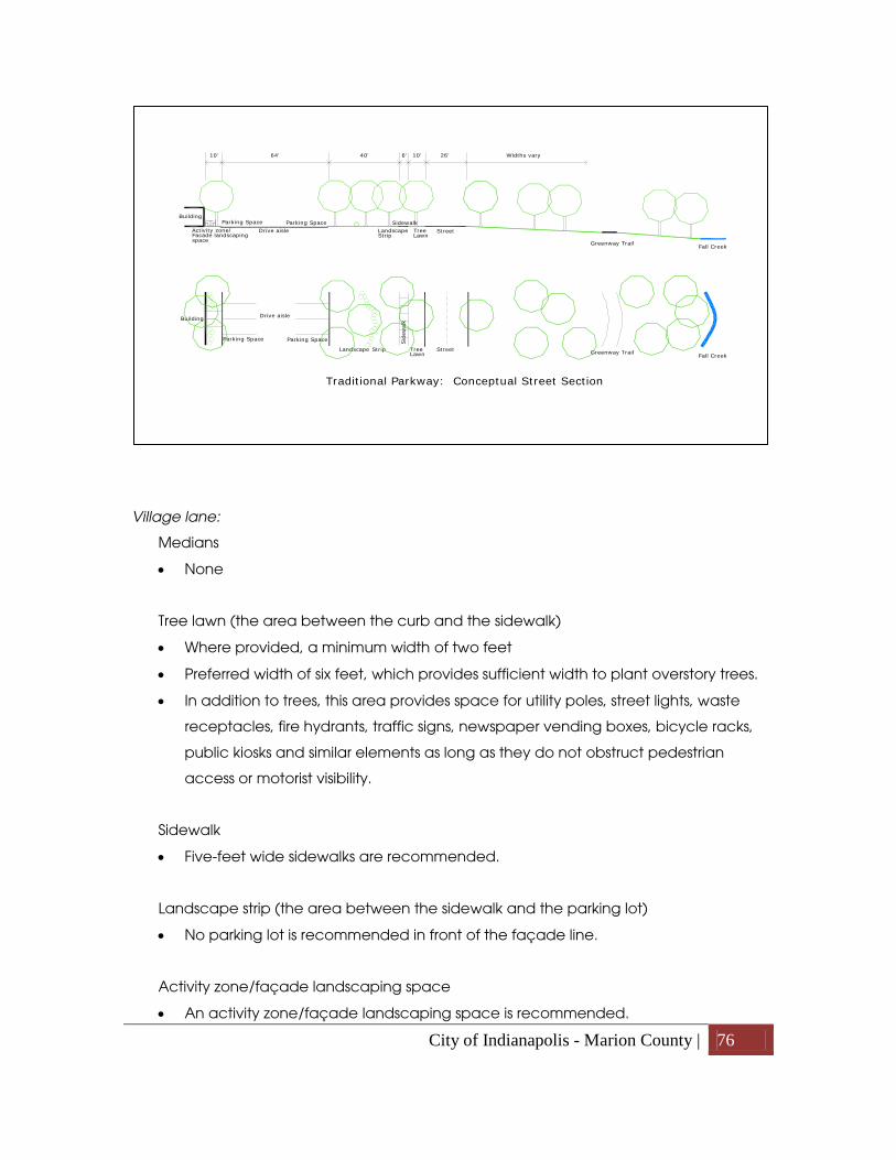
City of Indianapolis - Marion County | 76
Village lane:
Medians
• None
Tree lawn (the area between the curb and the sidewalk)
• Where provided, a minimum width of two feet
• Preferred width of six feet, which provides sufficient width to plant overstory trees.
• In addition to trees, this area provides space for utility poles, street lights, waste
receptacles, fire hydrants, traffic signs, newspaper vending boxes, bicycle racks,
public kiosks and similar elements as long as they do not obstruct pedestrian
access or motorist visibility.
Sidewalk
• Five-feet wide sidewalks are recommended.
Landscape strip (the area between the sidewalk and the parking lot)
• No parking lot is recommended in front of the façade line.
Activity zone/façade landscaping space
• An activity zone/façade landscaping space is recommended.
StreetTreeSidewalk
LandscapeLawnStrip
Parking SpaceDrive aisle
Parking SpaceBuilding
Activity zone/Facade landscapingspace
StreetTree
Sid
ewal
k
LandscapeLawn
Strip
Parking Space
Drive aisle
Parking Space
Building
Greenway TrailFall Creek
40' 10'6' 26' Widths vary10' 64'
Greenway TrailFall Creek
Traditional Parkway: Conceptual Street Section

City of Indianapolis - Marion County | 77
Pedestrian connections
All street types
Pedestrian connections include sidewalks along streets, crosswalks and on-site sidewalks
and marked pathways. For sidewalks along streets, see above.
Storefront and office entrances should be easily visible from the street and have an easily
identified pedestrian connection to the sidewalk paralleling the street. The pedestrian
connection should be at least five feet in width. Where a pedestrian connection crosses
a parking lot or drive lane the surface should be paved in a way that is distinct in
material, color or texture from the surrounding surface. Pedestrians should be protected
from overhanging parked vehicles through the use of medians or wheelstops.
Pedestrian connections between businesses on adjoining parcels are recommended.
Street
TreeSidewalk
Lawn
Building Building
TreeLawn
SidewalkActivity zone/Facade landscapingspace
West East
StreetTreeSid
ewal
k
Lawn
Building
Building
TreeLawn
SidewalkActivity zone/Facade landscapingspace
Varies based on historic setback 5' 6' 20' 6' 5' 20'
Building
Building
Village Lane: Conceptual Street Section
City of Indianapolis - Marion County | 78
Crosswalks
• Marked crosswalks should be provided at intersections.
• Mid-block pedestrian crossings may also be appropriate in a limited number of
locations.
• Crosswalks should be of a material that is visually distinct from the pavement of
the street. Examples include pavers, brick and colored asphalt.
Building orientation
All street types
Building orientation is how buildings relate to the street and each other. Visual cues tell
how the different sides of the building are meant to be used. Facades which front on a
street are the public face of the building and should have a high level of finishes. This
indicates a respect for the users of the street as well as indicating that this is the entry into
the building. These finishes should wrap around the sides of a building if these sides are
visible from the street.
Loading docks, trash containers, trash enclosures and other building services are part of
a building’s private realm and should not be visible from a street. On sites such as corner
lots where every side of a building may be visible from a street these private functions
should not be on a façade that faces the street or within the front 15 feet of the sides of
a building that do not face the street.
In the triangular block between Millersville Road and Emerson Way many parcels have
frontage on both streets. A potential development pattern on this block would be
ground-floor offices or retailing facing Emerson Way with second- and third- floor
residential units facing Millersville Road.
Building height
Building height is important in its relationships: among buildings, between buildings and
the street, buildings and the surrounding topography, and buildings and humans. Height
relationships affect sense of place by how space may or may not be enclosed and
whether the enclosure feels welcoming, protective or overbearing. Height relationships
also affect views. Views to and from structures should be considered as well as how
views may be directed.

City of Indianapolis - Marion County | 79
Current zoning requirements limit building height in the C1 district to 50 feet (4-5 stories), in
the C3 district to 35 feet (3 stories) and in the C4 district to 65 feet (5-6 stories). Current
zoning regulations do not set a minimum height.
Suburban Commercial Street, Medium intensity:
Building heights of one to three stories are recommended along these street faces.
Suburban Commercial Street, Low intensity
Because this is a transitional zone between residential area and more intense
commercial areas, the building heights should also be lower than in the more intense
commercial district: one to two stories.
Traditional parkway
Greater building heights are appropriate along the north side of Fall Creek Parkway due
to wider setbacks from the street and distance from residential areas. Building heights of
up to five stories are appropriate.
Village lane
Building heights on the east side of Millersville Road should be that of the Suburban
Commercial Street, Medium Intensity. Building heights on the west side should not
exceed that of the existing historic buildings (two stories/35 feet).
Fenestration
Fenestration is the number and size of openings (windows and doors) in a structure.
Fenestration creates rhythms and patterns on building facades that provide visual
interest and cues to the uses within the buildings. Expanses of blank walls tend to
deaden a space. Street level windows make a streetscape more pedestrian-friendly
and help activate the street. Lack of fenestration makes casual surveillance difficult,
which reduces safety and sociability.
Fenestration should be transparent to allow two-way viewing and should not use opaque
or mirrored glass. Opaque or mirrored glass does not fully provide the benefits of
transparent glass. The fenestration guidelines below refer to ground floors on street-
facing facades.

City of Indianapolis - Marion County | 80
Suburban Commercial Street, Medium intensity:
Transparency should be high. The closer to the street a building is, the higher the
transparency should be.
Suburban Commercial Street, Low intensity
Retail uses should be very transparent; transparency for other uses could be reduced but
no less than 25% of the area of the ground floor façade. The closer to the street a
building is, the higher the transparency should be.
Traditional parkway
No guideline for fenestration.
Village lane
On the west, historic side of the street the amount of fenestration should be similar to the
amount of fenestration of the existing buildings.
On the east side of the street, retail uses should be very transparent; transparency for
other uses could be reduced but no less than 25% of the area of the ground floor
façade.
Rooflines
The type of roof on a building can be a visual cue to the building’s use. Consistent
rooflines can add cohesiveness to an area. Typically residential rooflines such as gable
and hip roofs can help blend commercial structures into residential areas.
Suburban Commercial Street, Medium intensity:
No guideline for rooflines
Suburban Commercial Street, Low intensity
The low intensity suburban commercial streets are transitions between more intensive
commercial zones and residential areas. To help make the transition, rooflines on
commercial structures should be reminiscent of the residential rooflines in the
neighborhood or of prototypical residential rooflines such as gable or hip roofs. Flat roofs
are not recommended.

City of Indianapolis - Marion County | 81
Traditional parkway
No guideline for rooflines
Village lane
On the west, historic side of the street rooflines should be similar to the rooflines of the
existing buildings: front-gable, gambrel and hip.
On the east side of the street, which is transitional between the residential and
commercial districts, rooflines that are reminiscent of residential rooflines are preferred.
Parking: location, amount, sharing, and access
The amount and placement of parking has an effect on the area’s ease of use for
motorists, pedestrians and cyclists. Parking should be designed to be visually compatible
with the surrounding development, convenient for users, and mitigate the negative
impact of vehicle noise, headlights, lighting and mechanical systems. Physically
integrated, mixed-use development can provide parking efficiencies so that the amount
of total parking can be reduced. Provision of bicycle parking can make this area more
convenient for neighbors and users of the Fall Creek Trail and further reduce the amount
of space that needs to be devoted to vehicle parking.
Suburban Commercial Street, Medium intensity:
Maximum of one bay of parking in front of the front façade line. Shared access points
and integrated sites preferred. Parking lots over 20 spaces in size should have interior
landscaping of at least one tree per twelve parking spaces.
Bicycle parking provided.
Suburban Commercial Street, Low intensity
Maximum of one bay of parking in front of the front façade line. Shared access points
and integrated sites preferred. Parking lots over 20 spaces in size should have interior
landscaping of at least one tree per twelve parking spaces.
Bicycle parking provided.
Traditional parkway
Shared access points and integrated sites preferred. Parking lots over 20 spaces in size
should have interior landscaping of at least one tree per twelve parking spaces.

City of Indianapolis - Marion County | 82
Bicycle parking provided.
Village lane
No on-site parking in front of the front façade line. Shared access points and integrated
sites preferred. Parking lots over 20 spaces in size should have interior landscaping of at
least one tree per twelve parking spaces.
Bicycle parking provided.
Signage
Building signs are important to help people easily locate destinations. However, an
excessive amount of signage can detract from this purpose.
In all street typologies, signs should be designed creatively and artistically. Signs should
be compatible with the architectural pattern, style and fenestration of the building.
Building facades should be designed to incorporate building and business signs. Signs on
buildings are preferred to pole signs. Strobes, motion and other attention-getting devices
should not be used. EVMS (Electronic Variable Message signs) should not be used. Signs
in shop windows should not obscure more than a small percent of the window area. All
buildings should have the street address number clearly visible.
Off-premise advertising signs (billboards) are not appropriate in the village district.
Lighting
In all street typologies, exterior lighting should be carefully designed and provided to
direct people to their destinations, highlight architectural and landscape features and
create a safe and secure environment; however exterior lighting on private properties
should not overflow into the night sky, or onto adjacent rights-of-way or properties.
Adding distinctive public street lighting fixtures to the four village streets offers the
opportunity to create a sense of place in Millersville.

City of Indianapolis - Marion County | 83
Recommended Zoning Map
A recommended zoning map has been developed for the village area. The zoning plan
is intended to depict the most appropriate zoning district for each parcel based on its
recommended land use and the characteristics of the parcel and its surroundings.
Most of the village is recommended as Neighborhood-Village or NV. This zoning district is
used to implement form-based zoning. A more detailed description can be found in
Appendix G.
Typically implementation of a zoning plan is incremental over time as property owners
wish to develop or redevelop their properties. However the Metropolitan Development
Commission has the authority to rezone multiple parcels at one time. This is usually done
through a partnership with a community in an effort to implement a neighborhood or
corridor plan.
In the case of the NV zoning recommendation, it is not anticipated that this district would
be implemented on a parcel-by-parcel basis over a long period of time. This rezoning
would need to occur for multiple parcels at one time and include a regulating plan
detailing the components of the new district.
Until such time as the NV district is adopted, rezonings in the Village district should
promote the Village mixed-use recommendation of the land use plan and the street
typologies and design elements outlined in this plan.
Other zoning districts proposed for the village area are:
• C1 – Assisted living, auditoriums, community centers, day care, health services
(excluding hospitals), funeral homes, offices, radio and television studios, public
uses such as libraries and museums, adult education (excluding universities) and
subordinate accessory uses.
• D2 – Single family residential with a typical density of 1.9 units per gross acre
• D3 – Single family residential with a typical density of 2.6 units per gross acre
• PK1 – Park
• SU34- Fraternal organizations and public ballrooms

City of Indianapolis - Marion County | 84
• DP – Planned unit development. Predominantly residential in nature, but may
include other land uses. These developments may set many of their own
standards, but they are tied to a site plan and are more closely reviewed by the
Metropolitan Development Commission. This plan recommends DP only for those
sites currently zoned DP that are outside the proposed NV district.

City of Indianapolis - Marion County | 85

City of Indianapolis - Marion County | 86
Priorities The Millersville at Fall Creek Valley Village and Corridor Plan public input process
concluded by prioritizing the plan’s recommendations. Participants were asked to
choose their 18 highest priorities out of 53.
Previously, each of the four work groups had completed their efforts by prioritizing the
recommendations they had made. The most highly rated recommendations from each
work group made up the 53 priorities offered for consideration at the final public
meeting.
The most highly rated recommendation by a wide margin is:
• Add sidewalks and bike lanes to the 56th Street bridge.
The other most highly-prioritized recommendations are:
• Attract businesses to Millersville that will fulfill the range of neighborhood-level
retail and office needs.
• Create corridors that are safe and inviting for pedestrians, and bicyclists and still
move traffic in an efficient manner.
• Establish a streetscape in Millersville that is attractive, practical and reinforces the
identity of the area.
• Extend the Fall Creek Greenway Trail upstream to connect with the paved trail
within Fort Harrison State Park.
• Continue cooperation between the City and volunteer organizations to remove
invasive, exotic vegetation and replant native vegetation along Fall Creek.
• Use infrastructure to create a sense of place (e.g. public art, sculptural bridge
railings, artistic street furniture or unique crosswalk markings).
• Conduct a traffic study of Emerson Way from Kessler Boulevard to Laurel Hall with
the goal of maintaining traffic volume but increasing pedestrian safety and
convenience.
• Connect sidewalks, bike lanes and trails to regional systems.
• Amend City zoning codes to require stream protection corridors. Such corridors
would feature woody vegetation and minimal development.

City of Indianapolis - Marion County | 87
• Connect the sidewalks on the 46th Street, Emerson Way and 56th Street bridges to
the Fall Creek Greenway Trail.
• Continued action by the City to promptly address maintenance issues along the
Fall Creek Greenway Trail.
• Study Fall Creek Parkway between Emerson Way and 56th Street to create a more
park-like setting and re-route the trail to a less flood-prone location.
• Conduct a Traffic Study on 56th Street from Shadeland Avenue to Fall Creek to
look at traffic calming measures.
• Provide physical and visual connections among the Millersville businesses.
• Conduct a traffic study of 56th Street within Millersville with the goal of maintaining
traffic volume but increasing pedestrian safety and convenience.
• Add sidewalks and bike lanes to Emerson Way Bridge.
• Continue action by the City to remove or clear downed trees in Fall Creek.

City of Indianapolis - Marion County | 88
Appendices A. Relationships to other Plans
B. Extended History
C. Neighborhood Traffic Calming
D. Crime Prevention through Environmental Design
E. Aging in Place
F. Land use Categories
G. Neighborhood Village Zoning District
Appendix A: Existing Plans
The Millersville at Fall Creek Valley area has been the beneficiary of many years of City
planning efforts. In addition to Indianapolis Insight: the Comprehensive Plan for Marion
County, Indiana the following planning documents have guided the goals and actions
recommended in this plan.
Parks, Recreation and Open Space Plan
This Plan, adopted in 2009, documents the current status of Marion County’s park
systems. It develops a five-year blueprint for the creation and preservation of open
spaces, recreation facilities and parks. It also guides the formation of City policies, the
selection, implementation and coordination of City projects; and the development of
complementary and cooperative efforts by citizens and the City.
The Parks, Recreation and Open Space Plan indicates that the Millersville study area’s
needs for greenways and natural areas are served by Fall Creek Parkway, Woollens
Garden, Skiles Test Nature Park and Fort Harrison State Park. However the area is not
served for the types of active recreation provided by community and neighborhood
parks. The nearest neighborhood park to the study area is Gardner Park on 46th Street
west of Shadeland Avenue.
The Plan’s capital improvement projects list lists projects to be accomplished within five
years. Repaving of low areas on the greenway trail along Fall Creek is one of the projects
on the list.

City of Indianapolis - Marion County | 89
Greenways Plan
A master plan for Indianapolis Greenways was first adopted in 1994. It was the
culmination of a three-year planning effort that included Indy Parks, the National Park
Service and the Indianapolis Department of Metropolitan Development. The plan was
updated in 1999 and 2002. Another update is currently underway.
The current 2002 Indianapolis Greenways Plan describes the community’s vision for a
regional network of linear open space that connects neighborhoods and promotes
recreation, fitness, alternative transportation and conservation. The Indianapolis
Greenways Master Plan 2002 perpetuates the dream of park-lined rivers and streams
envisioned in the early part of the 20th century while answering the need for
reconnecting our communities together in the 21st century.
Among other purposes the Indianapolis Greenways Master Plan 2002 identified and
prioritized the development of greenway corridors and trails and identified key portions
of the Greenways System to be conserved or developed sensitively for passive
recreation. The Plan also encourages the protection of natural areas and the acquisition
of linear open space and greenways throughout the county.
This plan recommended extending the existing greenway trail northeast from the
intersection of Fall Creek Parkway and Kessler Boulevard into Fort Benjamin Harrison State
Park up to 79th Street. Extension of the trail southwest from the trailhead at the
intersection of Fall Creek Parkway, Binford Boulevard and Allisonville Road to the Monon
Rail-Trail was also proposed. The extension northeast was made as far as Woollens
Garden. The connection southwest to the Monon Rail-Trail was also completed.
Fall Creek Parkway, Woollens Garden, Skiles Test Park Master Plan
A Master Plan was developed for Fall Creek Parkway, Woollens Garden and Skiles Test
Nature Park in 1988. The Plan recommended improvements for all three of these Indy
Parks properties, which at that time were all undeveloped. Many of the improvements
recommended in the plan were constructed, most notably the paved trail, small parallel
parking areas and canoe launches along Fall Creek.
The plan called for opening views to the creek by selectively pruning the existing
vegetation. It also recommended maintaining the vegetation along the parkway in a

City of Indianapolis - Marion County | 90
tiered manner with natural woody vegetation along the stream, maintained turf along
the street and an intermediate area between the wooded stream bank and the turf for
wildflower plantings.
The Woollens Garden portion of the master plan recommended installation of a canoe
launch, minor picnic facilities, a footbridge over Fall Creek and nature trails.
Lower Fall Creek Watershed Management Plan (2009)
This plan was prepared for the Marion County Soil & Water Conservation District and the
Lower Fall Creek Watershed Alliance by Christopher B. Burke Engineering, Ltd. The
purpose of the plan was to examine water quality issues in the watershed and identify
sustainable, local solutions.
The study area of the watershed plan was the portion of the Fall Creek watershed
downstream of the Geist dam. The Indian Creek, Mud Creek and Devon Creek
watersheds were included in the study because these streams enter Fall Creek
downstream of the Geist dam. The watershed drains 57,800 acres and spreads over four
counties. The entire study area for the Millersville at Fall Creek Valley Village and Corridor
Plan lies within the study area for the watershed plan.
The watershed plan was organized by type of pollutant: sediment, nutrients and
pathogens. The watershed plan also identified Critical Areas, which are locations or
activities that particularly contribute to, or are particularly sensitive to, the degradation of
water quality in Fall Creek.
Indianapolis Regional Transportation Improvement Program (IRTIP)
The current Indianapolis Regional Transportation Improvement Program (IRTIP) includes
transportation improvements proposed for the Indianapolis Metropolitan Planning Area
for 2012 through 2015. The IRTIP is frequently amended to accommodate changing
needs and priorities. The basic objective of the IRTIP is to help local governments provide
the best attainable coordinated transportation system for citizens in this area.
In addition, the IRTIP provides a schedule by which to coordinate project implementation
among jurisdictions and agencies; a guide for implementation of other short- and long-

City of Indianapolis - Marion County | 91
range transportation plans; an aid to financial programming and administration; and a
source of information for the public.
Multi-Modal Corridor and Public Space Guidelines
This document makes recommendations for the development of multi-modal facilities in
order to realize the vision of a balanced transportation system. A multi-modal
transportation system is defined as a network of facilities designed for joint use with
connections between two or more modes of transportation. The recommendations of
this document were developed with the intent of implementation over time, as new
streets are constructed, as existing streets are reconstructed, and as land is developed or
redeveloped. Within the study area, these guidelines could be implemented to allow for
a more efficient connection to other modes of transportation such as sidewalks, bus lines,
bike paths, and other forms of mass transit in the future.
Indianapolis Regional Pedestrian Plan
The Indianapolis Metropolitan Planning Organization’s (IMPO) Regional Pedestrian Plan is
a framework for the creation of a regional pedestrian network. The intention of this plan
is to create a balanced transportation system throughout the metropolitan area that
considers the needs of the pedestrian in a manner similar to the needs of the
automobile. The plan documents the demand for pedestrian connections based on
qualitative and quantitative analyses. Results from these analyses are recorded as
recommended pedestrian facilities, corridors, and districts.
The commercial area at 56th Street and Emerson Avenue is recommended as a
pedestrian district. Binford Boulevard is recommended for an off-street path. The other
major streets in the study area are recommended for collector sidewalks.
A pedestrian district is an area characterized by a density of mixed uses and clustered
pedestrian destinations within a five-minute walk, supporting central or multiple transit
nodes. These are areas that have, or are intended to have, high pedestrian activity and
where priority is given to make walking the transportation mode of choice for trips within
the area.

City of Indianapolis - Marion County | 92
An off-street path is envisioned as a hard surface way, separated from the street, for
shared use by multiple alternative transportation users such as pedestrians, bicyclists, and
other non-motorized users.
A collector sidewalk is a hard surface walkway, for exclusive pedestrian use, along the
side of a street, within the right-of-way. It forms the primary grid of pedestrian facilities
that provides access to destinations. In comparison to the local sidewalk following local
streets, a collector sidewalk follows primary and secondary streets, streets with transit,
and streets that complete the pedestrian network.
Indianapolis Bicycle Plan
The Indianapolis Bike Plan and User Map project was initiated in 1999 by the Indianapolis
Metropolitan Planning Organization. The intent of this plan is to develop a system of
routes, including signed routes, bicycle lanes, off-street trails, and other types of facilities
that connect residential areas with shopping, employment centers, and recreation. This
plan is currently under revision.
Official Thoroughfare Plan (2002)
The Thoroughfare Plan documents the interconnecting and hierarchical system of
roadways that provides continuity and connectivity across Marion County. Where
appropriate the plan recommends street widenings and new street segments.
Street Segment Existing
ROW width
Existing Pavement
Width
Proposed ROW width
Proposed Pavement
Width
Priority
Allisonville Road, Kessler Blvd to Fall Creek Pkwy
90 24 120 24-24 B 2007-2015
Arlington Avenue, 56th St to 46th St
100 24-24 120 24-24 none
Binford Blvd, 75th St to Allisonville Rd
170 24-24 170 36-36 none
Emerson Way, Kessler Blvd to 56th St
50 22 120 24-24 none
Emerson Way, 56th St to Ladywood Dr
80 48 120 24-24 none
Emerson Avenue, Ladywood Dr to 39th St
100 24-24 120 24-24 none
Fall Creek Road, Shadeland Av to Kessler Blvd
75 22 120 24-24 none

City of Indianapolis - Marion County | 93
Fall Creek Parkway, 56th St to 46th St
100 36 100 48 none
Fall Creek Parkway, 46th St to Allisonville Rd
70 36 80 48 none
Kessler Boulevard, East Drive, Erie Ave to Binford Blvd
100 40 120 24-24 none
Kessler Boulevard, East Drive, Binford Blvd to Fall Creek Rd.
100 36 120 24-24 D 2021-2025
Kessler Boulevard, East Drive, Fall Creek Rd to 56th St
100 36 120 24-24 none
Shadeland Avenue, 56th St to Meadowview Dr
90 24-24 120 24-24 none
46th Street, Binford Blvd to Brown Rd
90 24-24 120 24-24 none
46th Street, Brown Rd to Ritter Av
90 24-24 120 24-24 none
56th Street, Kessler Blvd to I-465
100 24-24 120 24-24 none
I-465, 56th St to Pendleton Pk
200 36-36 300 36-36 none

City of Indianapolis - Marion County | 94
Appendix B: Extended History
The town of Millersville was never formally laid-out, incorporated or platted.
The 1884 “History of Indianapolis and Marion County, Indiana” by B. R. Sulgrove tells the
early story of Millersville. Seth Bacon and Peter Negley built a sawmill at what is now
Millersville in 1824. Unfortunately for them, the mill dam backed up water against an
upstream mill and damaged it. The owner of the upstream mill sued and ended up
owning Bacon and Negley’s mill as well as the eighty acres of land it sat on. This owner
sold the property to Noah Leverton in circa 1832. Leverton erected a gristmill near the
existing sawmill. This mill had a number of owners over the years including Jacob
Brubaker who built a distillery next to the grist mill. Sulgrove notes that the “place where
the village of Millersville now is was called Brubaker’s Mill before it gained its present
name.” Sulgrove dates the founding of Millersville to 1838.
The town’s heyday seems to have been the 1840s through 1860s. During this time the mill
and distillery were owned and operated by William Winpenny and Jacob Spahr. By 1884
Sulgrove writes that the village had “retrograded” to eighteen lots and a population of
86. At that time the village contained “fourteen dwelling houses, one blacksmith-shop, a
Masonic Hall building, two business houses, and one (water) flouring- and grist-mill.” The
post office, which had opened circa 1844, had closed by 1884. The town may have
been in decline in Sulgrove’s time, but he does describe at least one note of prosperity.
In 1882 the Millersville Free Library was opened to the public with “five hundred and fifty-
five volumes of the most judiciously selected books.”
Structures that remain from that time can be found at 5580 DeQuincy Street and along
the west side of Millersville Road. The Joseph Ringer-Johnson House on Dequincy Street
dates to circa 1855. The Millersville General Store at 5422 Millersville Road dates from
around 1870 and the Winpenny House at 5504 Millersville Road dates from circa 1865. In
between stands a Dutch Colonial Revival house at 5440 Millersville Road. It is more
recent, dating from circa 1910.
In 1909 a ravine-cut wooded parcel overlooking Fall Creek was offered to the City in a
letter from William Watson Woollen, local attorney, author and founder of the Nature
Study Club of Indiana. The letter enthusiastically described the site, “It is an ideal place.
No other such beautiful and desirable place can be found within the same distance

City of Indianapolis - Marion County | 95
from the center of this city.” Although the parcel was well outside City limits, the City
accepted Woollen’s offer.
Woollen conveyed the 44-acre property and his nature study library under several
conditions, including:
The place is to be known and designated . . . as Woollens Garden of Birds and
Botany. It is to be maintained and used as a place for nature study.
The wildwood of it is to be maintained a near as can be in its present wild
state.
The wildlife upon it . . . is not to be interfered with or destroyed; it is to be a
home and refuge for wild creatures which are found there or which may
come to it.
At the time of the donation a barn with a crib, a gardener’s cottage and a seven-room
double log cabin had been built on the site by Woollen. It was Woollen’s hope that the
log cabin would be maintained as a type of pioneer museum. However, all the buildings
on the site are now gone.
In 1916 Laurel Hall, the country estate home of banker Stoughton Fletcher and his wife
May, was completed on a bluff overlooking Fall Creek. The 38,000 square-feet mansion
was designed by Herbert L. Bass, architect of the Holcomb estate and the Test Building
on Monument Circle. It had 40 rooms and was maintained by a staff of ten. A notable
feature of the home was a winding three-story staircase hand-carved from native walnut
trees from the estate. The home was the site of elaborate lawn parties, balls, and
equestrian events.
Laurel Hall sat on an estate of nearly 1500 acres that included most of the area between
46th and 56th streets west of Arlington Avenue and southeast of Fall Creek. The main
entrance to the estate was through an elaborate entry gate with curving brick walls
flanking it. The brick walls can still be seen from Millersville Road across from Mallard
Lake. Other features of the ground were a stone water tower and lookout, greenhouses,
stables, horse trails, and three equestrian tracks. A Grecian temple stood at the top of a
cascade. The temple and cascade still exist on the grounds of Cathedral High School

City of Indianapolis - Marion County | 96
The sisters of Providence purchased Laurel Hall in 1925 and opened Ladywood School, a
residential girl’s school. In 1974 the structure was sold to Robert Welch who was
developing the adjacent Windridge Condominiums. Laurel Hall served as offices and
community center for Windridge until 1982. From 1984 to 2004 the structure was home to
the Hudson Institute, a public policy research organization. Laurel Hall is now the
headquarters and education center for Phi Kappa Psi. It also serves as a venue for
private events.
Over a fifty-year span Fletcher’s estate was divided and developed into the Mallard
Lake, Devon Ridge, Ladywood, Ladywood Bluff, Laurel Hall, Windridge, Devon Hills, First
Devington, Arlington Ridge, Arlington Park, and Brendonridge residential communities as
well as Cathedral High School.
Developer Charles S. Lewis established Brendonwood Common in 1917, making it the
earliest housing development in the study area. Lewis retained nationally-known
landscape architect George Kessler to plan and design Brendonwood Common as a
place for fine country living. One hundred ten lots were laid out on 250 acres between
56th Street (then known as Military Road) and Fall Creek. Kessler’s design worked with the
contours of the ravine-cut stream bluff location and took advantage of the wooded
hillsides. An additional 100 acres were reserved as common space for roadways,
walking and bridle paths, a golf course and other park and recreation amenities. The
golf course was laid out in 1923 by landscape architect Laurence V. Sheridan, an
associate of both Kessler and Lewis and later a resident of Brendonwood Common.
The homes in Brendonwood Common were built over a 62-year period in a variety of
styles. The peak of home construction activity was 1950 to 1954 when 37 houses were
built. Lots were intended to be bordered by wide swaths of high shrubbery making most
of Brendonwood’s lots very private yet today.
The idea of a parkway along Fall Creek originated in the early days of park planning in
Indianapolis. The first plan for a park system was developed in the late 1890s by John C.
Olmstead. The plan was updated about ten years later by George Kessler. In his 1909
“Report of Landscape Architect to the Board of Park Commissioners,” Kessler called for a
system of parks and parkways that “should bring within the easy reach of every potion of
a community the pleasant enjoyment of open air spaces for rest and recreation, and

City of Indianapolis - Marion County | 97
form pleasant and attractive means of communication from one part of the community
to another.”
Parkways along the White River and the city’s other major streams were a primary part of
Kessler’s plan. He described his concept of parkways to the commissioners as follows:
Parkways of this nature do not primarily form merely driveways from one
portion of the city to another, although their continuity for this purpose is
important, but, at variance with the popular idea of the boulevard, they do
from a chain of parks or a continuous park which is by its nature brought to
the doors of all sections of the community. By obtaining here and there open
spaces of considerable extent in addition to the space required for roadways
and walks, you will provide a continuous series of small parks and playgrounds
which will become very valuable and pleasurable to the neighborhoods in
their immediate vicinity. Where such parkways, as they will in your case,
follow the lines of picturesque streams, an additional interest in presented,
both in preserving the picturesque nature of the scenery and in the use of
streams for boating and bathing purposes.
Kessler’s report detailed each of the proposed parkways. He envisioned the Fall Creek
Parkway as “capable of most picturesque treatment, but is also to a large extent a
utilitarian feature. Here again it is contemplated to border each side with a driveway,
but the meanderings of the stream are such as to leave many park spaces of very
considerable extent, as well as the possibility of introducing here and there water
surfaces that are directly in the stream or to one side of it of sufficient area to add largely
to the attractiveness of the improvement.”
Kessler proposed acquiring land along Fall Creek from the White River upstream to 38th
Street and beyond as the city grew. By 1911 the City had acquired the entire north bank
of the creek from the canal upstream beyond the City limits at 38th Street. The city also
owned the south bank from Indiana Avenue downstream to the White River and from
Central Avenue downstream to 23rd Street. The City’s holding along Fall Creek at that
time totaled 143.3 acres.

City of Indianapolis - Marion County | 98
Open spaces, curvilinear roadways defined the character of the parkway. Trees were
planted to line the roadway and trees and shrubs were extensively used along the
parkway to define open spaces, frame views and lead the eye along the route.
The donation of Woollens Garden was an impetus to extend the parkway another six
miles. Federal work relief programs of the 1930s built the extension of the drive.
A 1928 update of Kessler’s plans by Lawrence Sheridan proposed the extension of Fall
Creek Parkway to the northeast county limit.
In the early part of the 20th century the area around Millersville was known for its diary
farms, including the Hornaday Milk Company and Roberts Dairy.
The north end of the Millersville commercial district is anchored by the Millersville Masonic
Lodge. The lodge was founded in Millersville in 1852. The lodge built and moved into its
current facility in the mid-1920s.
The Rolling Ridge subdivision, located off Allisonville Road, is the only pre-World War II
subdivision other than Brendonwood Common in the study area. The post-War period
however was a time of explosive growth within the study area. With a few notable
exceptions, by the mid1960s most of the available land in the study area had been
developed. The 1970s and 80s saw the development of the Windridge condominium
community and the 1980s, 1990s and 2000s was the time of development for the area
between Fall Creek Parkway and Fall Creek Road.
Little, if any, commercial development took place in the area until after Emerson Way
was built in 1962. The new Emerson Way bridge supplanted the Millersville Road bridge
and opened the area to easier travel from the south. Soon new commercial buildings
fronting on Emerson Way began to replace the old homes that had lined the east side of
Millersville Road. By 1972 the wedge-shaped area between Millersville Road and Emerson
Way had been completely redeveloped, the intersection of 56th Street and Emerson Way
had new commercial structures on all four corners and commercial development was
progressing east along 56th Street. In the next few years the area saw further
transformation as Fall Creek Parkway was re-routed and the Windridge Shoppes rose in
the area east of Emerson Way and south of 56th Street.

City of Indianapolis - Marion County | 99
Skiles Test Nature Park, located immediately outside the northeast corner of the study
area, sits on the bluff of Fall Creek facing Woollens Garden to the south. The park was a
bequest of successful Indianapolis businessperson Skiles Test. He left his northside estate to
the City in 1964 to be used for the benefit of Indianapolis’s young people. The City took
possession of the 81-acre site in 1974.
Skiles Test Nature Park, Woollens Garden and the Fall Creek Parkway formed a
continuous swath of undeveloped parkland that in 1988 was the subject of a park master
plan. The Plan recommended improvements for all three of the Indy Parks properties.
Many of the improvements recommended in the plan were constructed, most notably
the paved trail from Binford Boulevard/Allisonville Road to 56th Street, a trailhead at
Binford Boulevard/Allisonville Road, two canoe launches and small parallel parking areas
along Fall Creek.
The plan called for opening views to the creek by selectively pruning the existing
vegetation. It also recommended maintaining the vegetation along the parkway in a
tiered manner with natural woody vegetation along the stream, maintained turf along
the street and an intermediate area between the wooded stream bank and the turf for
wildflower plantings.
The Woollens Garden portion of the master plan recommended installation of a canoe
launch, minor picnic facilities, a footbridge over the creek, and nature trails. The park
was dedicated as a state nature preserve in 1987 as an excellent example of an old,
second-growth mesic upland forest community dominated by red oak, sugar maple,
white oak, shagbark hickory and ash. This designation did not change the ownership of
the property but it did bring an agreement to manage the site according to a state-
authored Master Plan.
A master plan for Indianapolis Greenways was first adopted in 1994. The plan was
updated in 1999 and 2002. The Indianapolis Greenways Master Plan 2002 perpetuates
the dream of park-lined rivers and streams envisioned by Kessler in the early part of the
20th century. This plan recommended extending the existing greenway trail northeast
from the intersection of Fall Creek Parkway and Kessler Boulevard into Fort Benjamin
Harrison State Park and up to 79th Street. Extension of the trail southwest from the
trailhead at the intersection of Fall Creek Parkway, Binford Boulevard and Allisonville
Road to the Monon Rail-Trail was also proposed. In 2007 the extension northeast was

City of Indianapolis - Marion County | 100
made as far as Woollens Garden. The connection southwest to the Monon Rail-Trail was
also completed.
The Greenways Master Plan is currently under revision. Completion of the plan is
anticipated in April 2011.
Although outside the study area, Fort Harrison State Park is a destination for many users of
the Fall Creek Greenway Trail. The state park was part of the conversion of a 25,000-acre
active military base into a mix of public and private land uses. The State of Indiana was
given 1,700 acres to form the park in 1995.
The Fall Creek Parkway and Woollens Garden were entered in the National Register of
Historic Places on March 26, 2003 by the United States Department of Interior. They were
part of a larger entry that encompassed the historic Indianapolis park and boulevard
system.
The nomination of the Fall Creek Parkway and Woollens Garden list the following features
as contributing to the historic character of the sites:
• The parkway drives, one on either side of the creek
• Parkway green space (site, design, materials)
• The spatial organization of the parkway
• Keystone Avenue Dam
• 56th Street bridge (1934, WPA built)
• Woollens Garden (natural conservation area)

City of Indianapolis - Marion County | 101
Appendix C: Neighborhood Traffic Calming Measures
“Traffic calming” usually refers to physical changes to streets in order to create safer
roads and a better quality of neighborhood life. Traffic calming is intended to:
• improve driver behavior, concentration, and awareness,
• reduce speed
• reduce cut-through traffic in neighborhoods, and
• improve safety for pedestrians, bicycles, and vehicles
• enhance quality of life and improve aesthetics.
When responding to a request for traffic calming in a neighborhood, the Indianapolis
Department of Public Works will conduct a study to determine the scope of the problems
and consider alternative solutions. DPW must also be satisfied that there is strong
neighborhood support. (Requests for traffic calming on arterial streets follow a different
process.)
The City’s Traffic Engineering staff will collect and analyze data and compare it with
established criteria to determine if the location is eligible for consideration. Findings and
conclusions will be documented in a formal report.
The Department of Public Work has a toolbox of traffic calming measures (see chart).
Depending on the following factors DPW will choose the appropriate tool.
• Citizen Support
• Street Classification
• Traffic Volume
• Traffic Speeds
• Street Geometric Data
• Accident History
• Input from Public Safety Agencies
• Cost and Funding
DPW will work with the community to determine the preferred traffic calming measure. A
neighborhood meeting will be required to review the results of the study. Traffic calming
measures will be implemented only if the neighborhood can show that 75% of those
affected are in support.

City of Indianapolis - Marion County | 102
Traffic Calming Measures
Horizontal Deflection
Curb extension / bulb-out
Areas of expanded curbing that extend across a parking lane and may narrow a travel lane.
Chicane Series of 3 bulb-outs, staggered at mid-block locations on alternating sides of the street.
Gateway Entrance treatment, typically using physical and textural changes, that provides identity to an area.
On-street parking Provision of on street parking that reduces roadway width.
Raised median island / pedestrian refuge
Narrow islands, at mid-block or intersections, between travel lanes with breaks in landscaping and curbing for pedestrians.
Traffic circle Raised island in the center of an intersection that requires vehicles to travel counterclockwise around the circle
Vertical Deflection
Textured crosswalk Use of pavers or other materials to demarcate crosswalks and alert motorists that they are entering a pedestrian-friendly area
Speed hump Raised humps in the roadway, typically 3 inches high with a 12 or 22-foot travel length.
Raised crosswalk Marked pedestrian crossings elevated 3 to 6 inches above street grade at intersections or mid-block.
Raised intersection Intersections, including crosswalks, raised 3 to 6 inches above street grade.
Physical Obstruction
Semi-diverter Directional closure created by physically blocking half the street.
Diagonal diverter Physical barrier placed diagonally across a four-way intersection to create two unconnected intersections.
Semi-diverter Directional closure created by physically blocking half the street.
Diagonal diverter Physical barrier placed diagonally across a four-way intersection to create two unconnected intersections.
Right-in / right-out island
The use of raised islands to prevent left turns and through movements, to and from side streets, at intersections with major streets
Raised median through intersection
Raised median through intersection median barrier through an intersection that discourages through traffic in a residential area by restricting movements
Raised median through intersection
Median barrier through an intersection that discourages through traffic in a residential area by restricting movements
Street closure The use of a cul-de-sac to close a roadway by extending a physical barrier across the entire width, obstructing all traffic movements

City of Indianapolis - Marion County | 103
Appendix D: Crime Prevention through Environmental Design
Excerpts from “Crime Prevention Through Environmental Design”
By Robert A. Gardner, 1981
The goal of CPTED is the reduction of opportunities for crime to occur. This reduction is
achieved by employing physical design features that discourage crime, while at the
same time encouraging legitimate use of the environment. CPTED offers protection
without resorting to the prison camp approach to security.
To understand fully how CPTED is used, one must examine its components and the
philosophy behind them.
Defensible Space
To provide maximum control, an environment is first divided into smaller, clearly defined
areas or zones. These zones become the focal points for the application of the various
CPTED elements. "Defensible space" is the term used to describe an area that has been
made a "zone of defense" by the design characteristics that create it.
Under the defensible space guidelines, all areas are designated as either public, semi-
private or private. This designation defines the acceptable use of each zone and
determines who has a right to occupy it under certain circumstances.
• Public Zones. These areas are generally open to anyone and are the least secure
of the three zones.
• Semi-private Zones. These areas create a buffer between public and private
zones and/or serve as common use spaces, such as interior courtyards. They are
accessible to the public, but are set off from the public zone. This separation is
accomplished with design features that establish definite transitional boundaries
between the zones.
• Private Zones. These are areas of restricted entry. Access is controlled and limited
to specific individuals or groups. A private residence is a good example of a
private zone.
Division between zones is generally accomplished with some type of barrier. These can
be either physical or symbolic.

City of Indianapolis - Marion County | 104
Physical barriers, as the name implies, are substantial in nature and physically prevent
movement. Fencing and locked doors are examples of physical barriers.
Symbolic barriers are less tangible. Nearly anything could serve as a symbolic barrier. The
only requirement is that it defines the boundary between zones. This type of barrier does
not prevent physical movement. All that is required is that it leaves no doubt that a
transition between zones has taken place. Low decorative fences, flower beds, changes
in sidewalk patterns or materials, and signs are examples of symbolic barriers.
Territoriality
Territoriality involves an individual's perception of, and relationship with, the environment.
A strong sense of territoriality encourages an individual to take control of his or her
environment and defend it against attack.
A sense of territoriality is fostered by architecture that allows easy identification of certain
areas as the exclusive domain of a particular individual or group. This feeling is enhanced
when the area involved is one the individual can relate to with a sense of pride and
ownership.
The term ownership when used in this context does not necessarily mean actual legal
ownership. It can be, and very often is, a perceived ownership resulting from an
individual's relationship with the environment.
Surveillance
Surveillance is the principal weapon in the protection of a defensible space. Criminals
are least likely to act when there is a high risk of their actions being witnessed.
Environments in which legitimate occupants can exercise a high degree of visual control
increase the likelihood of criminal acts being observed and reported.
Informal Surveillance. Opportunities for informal or natural surveillance occur as a direct
result of architectural design. Designs that minimize visual obstacles and eliminate places
of concealment offer the most protection against crime. These open designs also
encourage use of the environment, as people feel safer when they can easily see and
be seen.

City of Indianapolis - Marion County | 105
The use of defensible space in conjunction with natural surveillance is a potent crime
prevention tool. The establishment of transition zones gives both the occupant and the
intruder clear and definite points of reference. For the occupant, an intruder's entrance
into restricted space creates cause for attention and possible alarm. For the intruder,
entering restricted space spotlights his actions, elevates his anxiety level, and greatly
increases his risk of being discovered and apprehended.
Lighting
Good lighting is one of the most effective crime deterrents. When used properly, light
discourages criminal activity, enhances natural surveillance, and reduces fear.
The type and quantity of light required will vary from application to application, but the
goal remains the same in all cases. To the degree possible, a constant level of light
providing reasonably good visibility should be maintained at night. The absolute level of
light, provided it meets minimum standards, is less critical than the evenness of the light.
Bright spots and shadows should be avoided. Highly vulnerable areas and those that
could conceal a potential attacker should be illuminated more brightly than areas
designed for normal activity. The object is to light up the criminal without spotlighting the
victim.
As used in CPTED, lighting also plays a part in creating a feeling of territoriality. A bright,
cheerful environment is much more pleasing than one that appears dark and lifeless. The
ability to feel good about one's environment is important in developing a sense of pride
and ownership.
Landscaping
Landscaping design, like architectural design, plays a significant role in CPTED.
Landscaping is versatile and can be used to perform a variety of design functions.
As a symbolic barrier, landscaping can mark the transition between zones. Features such
as decorative fencing, flower beds, ground cover, and varied patterns in cement work
can clearly show separation between zones. If more substantial barriers are needed,
shrubbery such as evergreen hedges can be used to create more formidable obstacles.
City of Indianapolis - Marion County | 106
From a surveillance standpoint, landscaping can be critical. Such factors as growth
characteristics of plants and their placement in relation to potentially vulnerable areas
are extremely important.
Visual corridors must be maintained in open, park-like areas as well as in densely planted
areas. As a rule, visual surveillance corridors can be maintained by limiting shrubbery to a
maximum height of three feet and trees to a minimum height of six feet at the lowest
branches. This approach ensures that visibility between three and six feet from the
ground will always be relatively unimpaired.
Another function of landscaping in crime prevention is aesthetics. Again, an attractive
environment generates a sense of pride and ownership.
Physical Security
Enlightened physical security planning can contribute considerably to the overall success
of a project. The proper application of security hardware and the elimination of security
weaknesses from a structural standpoint can have a significant impact on future crime
problems.
As an element of CPTED, physical security planning is not intended to create an
impenetrable fortress. The goal is merely to make penetration more difficult and time-
consuming. Degree of difficulty and length of delay are key factors in reducing the
probability that crime will occur.
The emphasis of CPTED is not just on the tools, however. It is how the tools are used that
makes the difference. Normally, a building is built and then secured. With CPTED, it is
secured, then built. More importantly, not just the building is secured but also the space
around it. The security program is integrated into the environment, not just added on.

City of Indianapolis - Marion County | 107
Appendix E: Aging in Place
The “Aging in Place” concept is about helping senior citizens to live in the residence of
their choice while being able to have services available when they need them. The
main goal is to keep seniors in their homes and take care of their needs.
Many times this happens in areas called a NORC (Naturally Occurring Retirement
Community). These are neighborhoods or buildings in which there is a large population
of senior citizens. These areas are not usually set up as communities and tend to form on
their own. Aging in place and NORC provide similar services to senior citizens.
Many Hoosiers are beginning to approach retirement. They are trying to find ways to
plan their retirement and still live at home. People may not realize but there are many
services in Indianapolis for aging in place. There are many services dedicated to not
only keeping seniors in their homes, but to helping them with everyday issues.
The following organizations offer similar but different opportunities for ageing in place.
Their goal is to help senior citizens stay in their homes and to assist them in any way
possible.
• Agingavenues.com- helps senior citizens find services in Indianapolis. They
provide a whole list of services for aging in place seniors in Indiana.
• Timeless Homes- provides a list of home projects provided by Timeless Homes
Independent Lifestyle Support Services. They will assist senior citizens with
household tasks from changing a light bulb, to installing handrails. They will also
assist with landscaping. Visit www.timelesshomesindy.com/aginginplace.php.
• Agingindiana.org-their goal is to provide senior citizens, with an outreach
program within their communities. This began in 2006, when the AdvantAge
Initiative was brought to Indiana. It was funded by the US Administration on
Aging (AoA) and the Indiana Family and Social Services Administration Division of
Aging.
• In.gov/fssa/2329.htm- this gives a list of services and programs that benefit senior
citizens.
• jfgi.org/section.aspx?id=284- the Jewish Federation of Greater Indianapolis helps
seniors age in place. Their main goal is to help establish more elder-friendly
communities.

City of Indianapolis - Marion County | 108
• NAIPC (National Aging in Place Council) is a senior citizen support network. They
provide experts in healthcare, financial services, home design and remodeling,
and many more.
City of Indianapolis - Marion County | 109
Appendix F: Land Use Categories
Land use categories broadly define development by use and intensity, and should be
considered the most appropriate use for the land. They are the starting point for
determining the appropriateness of land use requests such as zoning and variance of use
petitions.
Residential Development greater than 0.00 and equal to or less than 1.75 units per acre.
Color: Vanilla
Index Number: 1
This density is consistent with rural development patterns and could also limit the impact
of development on property with extreme topography or other significant environmental
considerations such as floodplains, wetlands and old-growth woodlands. Additionally,
this density would be conducive to agricultural and estate development.
Residential Development greater than 1.75 and equal to or less than 3.50 units per acre.
Color: Light Yellow
Index Number: 2
This density is consistent with single-family residential development in transitional areas
between rural and suburban development patterns and is the typical density for single-
family residential development in suburban areas of the City. Development at this
density should not take place in rural and suburban areas where surrounding
development patterns exhibit characteristics suitable for higher densities (property on
mass transit corridors, near concentrations of employment, or near major commercial
centers, for example).
Residential Development greater than 3.50 and equal to or less than 5.00 units per acre.
Color: Bright Yellow
Index Number: 3
This density is consistent with single-family residential development in suburban areas of
the City and in transitional areas between suburban and urban patterns of development.
Development at this density should not take place on mass transit corridors. Multi-family
residential development is acceptable, but is unlikely considering the density ranges
recommended.

City of Indianapolis - Marion County | 110
Residential Development greater than 5.00 and equal to or less than 8.00 units per acre.
Color: Orange
Index Number: 4
In suburban and rural areas this is a common multi-family density and typically the
highest density single-family category in suburban areas. In urban areas, it is common for
both single-family and multi-family development. Development at this density is
appropriate along bus corridors but should not take place in proximity to planned light
rail transit stops.
Residential Development greater than 8.00 and equal to or less than 15.00 units per acre.
Color: Light Brown
Index Number: 5
This density is typically the highest density serviceable in suburban areas. In suburban
areas it would typically be a multi-family (apartment or condominium) category. In
urban areas, this is the highest density single-family residential category and a common
multi-family category. Development at this density is appropriate for all types of mass
transit corridors.
Residential Development greater than 15.00 units per acre.
Color: Dark Brown
Index Number: 6
This density is appropriate only within relatively intense urban areas where there is a full
range of urban services and where those services have the capacity to accommodate
the development. It may be appropriate in rare circumstances in suburban areas as
assisted-living housing and as a buffer between major retail commercial uses and lower
density residential uses. Development at this density is appropriate for all types of mass
transit corridors.
Village Mixed-Use
Color: Peach
Index Number: 8
This land use category consists of a development focused on a mixed-use core of small,
neighborhood office/retail nodes, public and semi public uses, open space and light
industrial development. Residential development densities vary from compact single-
family residential development and small-scale multi-family residential development near

City of Indianapolis - Marion County | 111
the “Main Street” or “Village Center” and progress to lower densities outward from this
core. Village mixed use areas are intended to strengthen existing, historically rural, small
towns and cities within Indianapolis, which are intended to continue as neighborhood
gathering places and should allow a wide range of small businesses, housing types, and
public and semi-public facilities. This category should be compatible in size and scale to
existing villages in Marion County. It will allow development of residential and limited
commercial uses on smaller lots than in other sections of rural and suburban Indianapolis.
Potential development in these areas should focus on design issues related to
architecture, building size, parking, landscaping and lighting to promote a pedestrian-
oriented “village” or “small town” atmosphere, rather than focusing on residential
density. Strip commercial development (integrated centers setback from rights-of-way
by parking areas), large-scale freestanding retail uses and heavy industrial development
are generally inappropriate within this land use category. The Plan anticipates that this
category will typically be designated as a critical area.
Office Commercial Uses
Color: Pink
Index Number: 13
This land use category is for low-intensity office uses, integrated office development and
compatible office-type uses. Retail uses are not promoted in this category, unless those
uses are significantly subordinate to the primary office use or the retail use exclusively
serves an abundance of office uses in proximity to the retail use. Office Commercial Uses
can exist either as buffers between higher intensity land uses and lower intensity land uses
or as major employment centers. The following uses are representative of this land use
category: medical and dental facilities, education services, insurance, real estate,
financial institutions, design firms, legal services, day care centers, mortuaries, and
communications studios.
Community Commercial Uses
Color: Red
Index Number: 14
This land use category is for low-intensity retail commercial and office uses, which serve a
predominantly residential market adjacent to, or very near, the location of the use. The
uses in this land use category are designed to fulfill a broad range of retail, personal,
professional and business services and are either freestanding or part of a small

City of Indianapolis - Marion County | 112
integrated center typically anchored by a grocery store. These centers contain no, or
extremely limited, outdoor display of merchandise. Generally, these uses are consistent
with the following characteristics:
Maximum Gross Floor Area: 125,000 square feet
Maximum Acreage: 25 acres
Service Area Radius: 2 miles
Location: On an arterial or at the intersection of an arterial with a collector.
Maximum Outlots: 3
Regional Commercial Uses
Color: Rust
Index Number: 16
This land use category is for general commercial and office type uses, which serve a
market that encompasses several residential neighborhoods or communities. The uses in
this land use category tend to benefit greatly from major business grouping and regional-
sized shopping centers; therefore, this land use category may consist of a collection of
relatively large freestanding commercial uses and integrated centers. These uses are
generally characterized by indoor operations, but may have accessory outdoor
operations limited to approximately 5 to 10 percent of a use’s gross floor area.
Generally, these uses are consistent with the following characteristics:
Maximum Gross Floor Area: 1,000,000 square feet
Service Area Radius: 15 miles
Location: On a primary arterial near the intersection with a
secondary or primary arterial.
Maximum Outlots: As needed.
Heavy Commercial Uses
Color: Dark Red
Index Number: 15
This land use category is for general commercial and related office type uses. The uses in
this land use category tend to exhibit characteristics that are not compatible with less
intensive land uses and are predominantly devoted to exterior operations, sales and
display of goods; such as automobile sales and heavy equipment sales.

City of Indianapolis - Marion County | 113
Location: On a primary arterial
Park
Color: Green
Index Number: 10
This land use category consists of public or private property designated for active and/or
passive recreational amenities. It also includes publicly and privately held conservation
and preservation areas.
Linear Park
Color: Green
Index Number: 11
This land use category consists of public or private property designated for active and/or
passive recreational amenities and is primarily used for the passage of people or wildlife.
Typical examples are greenways and parkways.
Special Use
Color: Grey
Index Number: 12
This land use category consists of a variety public, semi-public and private land uses that
either serve a specific public purpose (such as schools, churches, libraries, neighborhood
centers and public safety facilities) or are unique uses exhibiting significant impacts on
adjacent property (such as the Indianapolis International Airport, Indiana State Fair, and
Indianapolis Motor Speedway).
Floodway
Color: Blue
This land use classification consists of areas within the floodway. These areas exhibit a
great potential for property loss and damage or for water quality degradation and
should not be developed. Nonconforming uses currently within a floodway should not
be expanded.
City of Indianapolis - Marion County | 114
Appendix G: Proposed Neighborhood Village (NV) District
This zoning district is one method of implementing the Village Mixed-Use
recommendation of the Comprehensive Plan. It is intended to:
• Preserve and restore existing, traditional and pedestrian scale buildings in
established neighborhood commercial districts;
• Create new commercial nodes that are pedestrian-oriented and provide uses that
primarily serve adjacent neighborhoods;
• Promote a balance of retail, service, office, dining and residential uses that serve
the adjacent neighborhoods;
• Alleviate development pressure on existing neighborhoods by placing reasonable
controls on development and expansion of strip commercial areas within
neighborhoods, particularly larger scale auto-oriented retail, service, office and
dining uses that are intended to serve larger areas of the city;
• Facilitate safe, attractive and convenient pedestrian circulation and minimize
conflicts between pedestrians and vehicles;
• Encourage pedestrian flow through the design of mixed-use buildings with ground
floor level retail uses that open directly onto sidewalks adjacent to public streets;
• Establish building facade lines and sidewalk requirements, and reserve the space
between buildings and the street for pedestrian functions;
• Promote a nodal form of neighborhood commercial development that is of such a
size that all uses within the district are within a convenient walking distance of one
another and economically sustainable.
Although the NV district is more about the “how” of development rather than the
“what,” it is still helpful to distinguish between appropriate and inappropriate land uses in
the village.

City of Indianapolis - Marion County | 115
Appropriate uses Inappropriate uses
Uses that generate pedestrian traffic
Uses that generate mostly vehicular traffic
Uses that are pedestrian-scaled Uses that require a lot of space compared to the amount of pedestrian traffic they create
Uses that primarily serve the adjacent neighborhoods
Uses that require a lot of parking
Uses that minimize conflicts between pedestrians and vehicles
Uses that create conflicts between pedestrians and vehicles
A mix of retail, service, office, dining and residential uses
Uses that require a lot of outdoor storage or display
Proposed list of appropriate uses within a Millersville NV district:
• Retail Sales
• Office, studio, clinic, and similar uses
• Cultural center, museum, art galleries, libraries, and similar cultural facilities
• Education institutions (pre-K to 12th grade) (appropriate on the traditional
parkway street typology, appropriate on other street typologies if limited in size)
• Education institutions (after 12th grade)
• Religious Uses
• Residential, multifamily
• Group Home for developmentally disabled
• Supportive housing, family care homes, congregate care homes, and assisted
living (but limited in size)
• Lodging, hotel, bed & breakfast
• Automobile fueling & convenience (but limited in number)
• Automobile repair /service (but limited in size)
• Bar, Tavern or Nightclub (but limited in size)
• Bakery (Artisan, not industrial wholesale bakery)
• Commercial recreation or amusement establishments, such as theaters and
other places of assembly and similar uses with primary activities conducted within
fully enclosed buildings
• Day care center

City of Indianapolis - Marion County | 116
• Furniture, Home improvement, Appliance store (sales/rental/repair) (but limited in
size and amount of outdoor storage and display)
• Grocery store
• Laundry and dry cleaning collection station
• Liquor sales
• Microbrewery (Artisan distillery)
• Personal Service establishment
• Restaurant, coffee shop, delicatessen, and other eating establishments
• Tailoring, custom dressmaking, millinery and similar establishment.
• Veterinary, Animal care/boarding/hospital
• Bus stop
• Mobile vendor
• Parking garage (but with active ground-floor uses such as retailing)
Proposed list of inappropriate uses within a Millersville NV district:
• Nursing home
• Community gardens
• Residential, detached single-family or two-family
• Automobile sales/rental/leasing, new/used
• Automobile washing
• Boat and RV sales/rental/leasing, new/used
• Drive-in, drive-thru or drive-up service window (inappropriate if wider than one
lane at the point it crosses a pedestrian way)
• Adult entertainment
• Outdoor commercial recreation or amusement establishment (appropriate only
in the traditional parkway street typology)
• Funeral home
• Laundry plant, dry cleaning plant
• Parking lot (commercial, surface)
• Power/gas substation
• Radio/TV/satellite/telecommunications tower
• Safety services (police, ambulance, fire)
• Self-service storage

City of Indianapolis - Marion County | 117
These lists of uses should be further reviewed and modified to suit the specific needs of
Millersville at the time a regulating plan is developed.

City of Indianapolis - Marion County | 118
Appendix H: Participants
Rick Alexander, Windridge Condominiums Owners Association
Eric Altherr, Brendon Forest
Debbie Anderson, Brookdale Place at Fall Creek Senior Living
Sharon Arnold, Devington Community Development Corporation
William Arnold, Brendonshire Civic Association
Brenda Barker, Brendonwood Common
Julie Barnes Smith, Kessler Commons
Carl and Barbara Barnett
John Bartlett, Indiana House of Representatives
David and Carolene Bash
Jennifer Beesley
Kathy Bennett, Devon Neighborhood Association
Lois Bennett, Windridge Condominium Owners Association
Matt and Mollie Benson, Lake Kesslerwood East
Robert and Julie Benson, Mallard Lake Community Association
Doug Beyers, Windridge Condominium Owners Association
Tom Bonsett, Brendonshire Civic Association
Jean Breaux, Indiana Senate
Greg Brelage, Brelage Insurance Company
Ray Brinkmeyer, BRAG
Joe and Dianna Broecker, Lake Kesslerwood
Doris Cantrell
Breck Carden, Carden Commercial LLC
Joe Carey, Windridge Condominium Owners Association
Louis and Emily Chenette, Lake Kesslerwood
Debra Cooper, National Council of Negro Women, Lawrence Section
Mary Martha Costello, Windridge Condominium Owners Association
Robert Craig, Brendonshire Civic Association
Jerry and Marilyn Dapper, Creekview Estates
Lois Daugherty, Kessler View Neighborhood Association
Pamela Davis
Terry Dearing, Boardwalk Homeowners Association
Catharine Diehr, Millersville @ Fall Creek Valley Board
Bill Dowden, Kessler Commons
Tom and Judy Eggers, Windridge Condominium Owners Association

City of Indianapolis - Marion County | 119
Doug Euers, Millersville Masonic Lodge
Dan Evard, Windridge Condominium Owners Association
James Farrell, Fatima Retreat House
Jennifer Faucett, Evergreen Florist
Lew and Iwana Fields, Devon Neighborhood Association
Joan FitzGibbon, Brendonwood Common
Terry Fleck, Lake Kesslerwood
Millie Fleming-Moran, Kessler Commons
Tony Ford, Community Hospital North
Deborah Freije, Brendon Forest
Zorina Galis, Millersville @ Fall Creek Valley Board
Keith and Diane Gardner, Millersville @ Fall Creek Valley Board
Lee and Krisma Garrett, Garrett’s Smokehouse BBQ
Jane Gehlhausen
Tracy Gillen, Friends of Skiles Test
Mike Glenn, Brendonridge Homeowners Association
Johnny Goldfinger, Mallard Lake Community Association
Charlie Goodman
William and Natalie Gordon
Reggie Greene
Hannelore Greven, Roxbury Arms
Susan Haber, Brendonwood Common
Melinda Hall, Millersville @ Fall Creek Valley Board
Paula Hall, Brendonwood Common
Mark and Susan Handy
Deb Harlamert
Judie Hawley Conley
Pat Hellman, Rolling Ridge Neighborhood Association
Stan Hirsch, Law Office
Rosemary Huffman
David Hunter, Brendon Park Civic Association
Bill Hurrle, KELA
Evie Infanger
Larry & Pat Jaggers
Camille James, Brendon Park Neighborhood Association
Carla James, Brendon Park Neighborhood Association
Carlyn Johnson, Brendonwood Common

City of Indianapolis - Marion County | 120
Keith Johnson, City of Lawrence
Dr. Don Kalt, Noah’s Animal Hospital
Bill Kennedy, Marine Bank
Alicia F. King
Kirby Kinghorn, Muesing Management
Bruce Knox, Garden Walk
Joe Komenda, BRAG
Denny Krauser, Fall Creek Manor Block Club
Barbara Lee, Millersville @ Fall Creek Valley Board
Edie Leet, Devonshire II & IV Residential Association
Roy Levin, Brendon Forest
Ellen Love-Pendleton, Devon Country Club
Jiansen Lu, Happy Garden
Merlyn and Hane Malola, Windridge Condominium Owners Association
Dennis Mannina, Brendonridge Homeowners Association
Rusty Marlen, Fall Creek Valley
Wil Marquez, w/Purpose
Marilyn and Jack Mart, Windridge Condominium Owners Association
Melissa Mau, Lake Kesslerwood
Katrina May, Eden’s Pathway
Mary Ann McCormick, Windridge Condominium Owners Association
Sean McGinley, Brendon Forest
Robert and Louise Malachowski, Brendon Forest
Sheila McKinley, Christopher B Burke Engineering
Sandra McLin, Garden Walk Town-homes Homeowners Association
Jim McLinn, Cathedral High School
Marta Meeker, Mallard Lake Community Association
Jon Miller, Ladywood Estates
James Naff, Devon Neighborhood Association
Jane and Pat Nash, Lake Charlevoix
Steve and Dawn Neal, Lake Kesslerwood
John and Mary Jane Norman, Law Office
Alan Norris, Windridge Condominium Owners Association
John Nurnberger, Indiana University
Berton O’Bryan, Brendon Forest
Christine Pitzer, Creekview Estates

City of Indianapolis - Marion County | 121
Kevin and Cathy Potter, Brendonwood Common
Kostas Poulakidas, Rolling Ridge Neighborhood Association
Harini Rajagopalan, Lake Charlevoix
Betty and J. Parke Randall, Devon Neighborhood Association, Inc.
Eric Rasmussen, Regions Bank
Alicia Reuter, Brendonridge Homeowners Association
Cassie Rice
Larry Riggle, Avalon Hills Civic Association
Kim Robertson, Brendonwood Common
Joe and Gina Rogers, Mallard Lake Community Association
Shirley Rohnke, Mallard Lake Community Association
Theresa Rohr-Kirchuraber
Gary Rosenberg, Millersville @ Fall Creek Valley Board
Eric and Sally Rowland, Brendonwood Common
Sallie Rowland, Millersville @ Fall Creek Valley Board
Barb Sahm, Lake Kesslerwood
Terence Sauer, Brendonshire Civic Association
Christine Scales, City-County Council
Scott and Catherine Schoenherr, Brendon Forest
Marge Scott, Kessler View Neighborhood Association
Les Sebring, United Surety Agents, Inc.
Lara SerVaas, Kessler View Neighborhood Association
Doug Shannon
Fr. Paul Shikany, St. Matthew Catholic Church
Jay Simmons, Windridge Office Building
Pat Soper, Roxbury Arms
Phyllis Starks, Kessler Commons
Justin Sterling
George Stevens, Stevens Property Group
Michael Stevens, Stevens Property Group
Rosemary Tanner, Brendonwood Common
Crystal Thomas, Noah’s Animal Hospital
Dr. Mike Thomas, Noah’s Animal Hospital
Nancy Thompson, Brendon Forest
Tom Ulsas, Windridge Condominium Owners Association
Kim VanArsdale, Marine Bank
Julie and Solomon Webb

City of Indianapolis - Marion County | 122
Tess White, White and Champagne
Molly Wilkens, Brendonwood Common
Al and Hanna Will
Daryl Williams-Dotson
Hannah Woodard, Brookdale Place at Fall Creek Senior Living
Cindy Woods, Boardwalk Homeowners Association
Joyce Woodson, Mini Blessings Childcare
George Wright, Lake Charlevoix
Stephen Yoder
John Zubak, Millersville @ Fall Creek Valley Board

City of Indianapolis - Marion County | 123
Mayor’s Neighborhood Liaison
Noelle Malatestinic
Department of Metropolitan Development
Division of Planning
Keith Holdsworth, Principal Planner
Gina Bush Hayes, Planner
Larry Calloway, Principal Planner
David Hittle, Senior Planner
Melanie Mullens, Senior Planner
Tammara Tracy, Principal Planner
Jeff York, Senior Planner
Department of Metropolitan Development
Metropolitan Planning Organization
Tom Beck, Principal Planner
Stephanie Belch, Principal Planner
Steve Cunningham, Principal Planner
Jeremy Moore, Senior Planner
Anna M. Tyszkiewicz, Principal Planner
Department of Parks and Recreation
Don Colvin, Deputy Director
Ron Banks, Senior Greenways Manager
Andre Denman, Principal Planner
Al Ensley, Greenways Manager
Ben Jackson, Senior Planner
Christina Jones, Senior Planner
Don Miller, Land Stewardship Supervisor
Jeff Ward, Environmental Education and Land
Stewardship Administrator
Department of Public Works
Andy Lutz, Senior Project Manager
Andrew Mertz, Urban Forester
John Oakley, Assistant Administrator
Nathan Sheets, Assistant Administrator
Department of Code Enforcement
Katie Bannon
Johnny Guest, Administrator for Property Safety
and Maintenance
Marion County Health Department/
Bureau of Environmental Health
Anthony Burke
Laura Morgan