Embed Size (px)
Citation preview
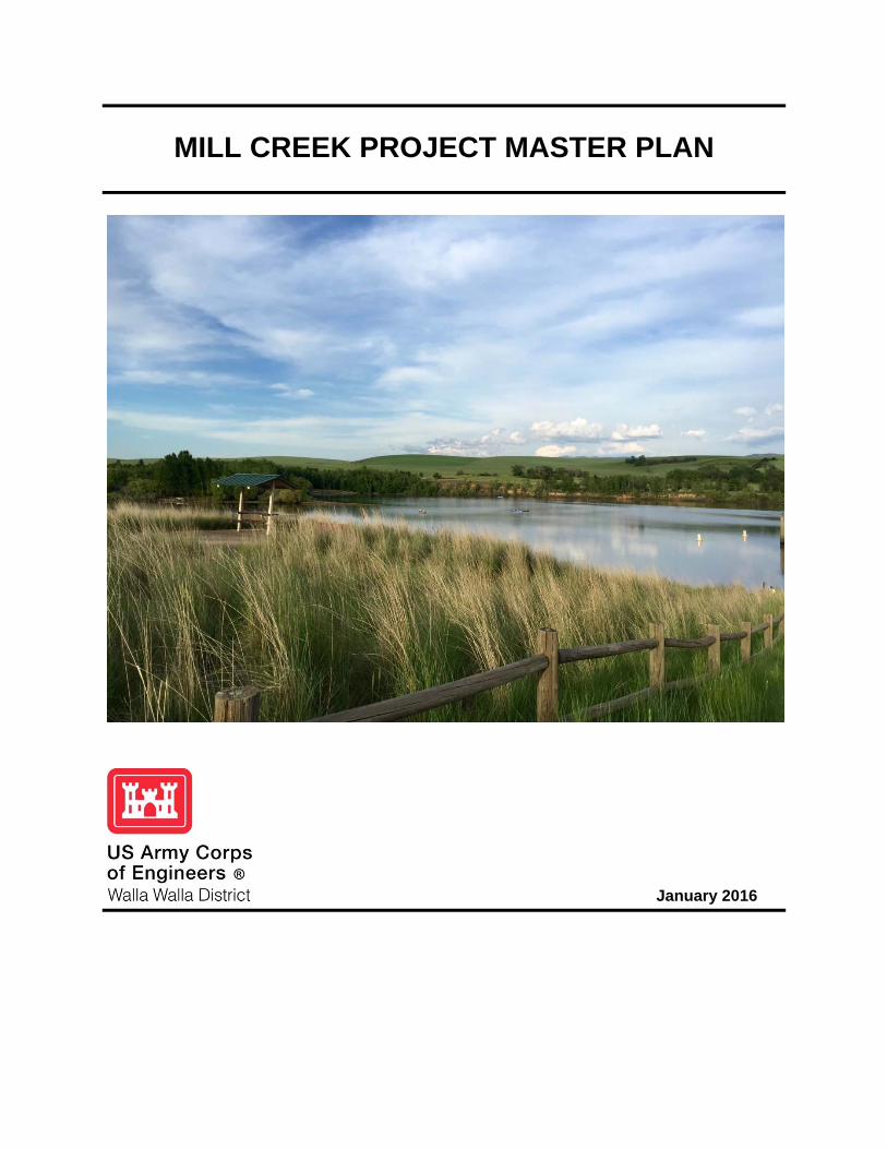
MILL CREEK PROJECT MASTER PLAN
January 2016
PREFACE The Master Plan for Mill Creek Project was first approved in May 1, 1961. Subsequent revisions were prepared with the latest revision approved on November 20, 1993. The Master Plan is intended to serve as a guide for the orderly and coordinated development, management, and stewardship of all lands, facilities, and water resources of the project. It presents data on existing conditions, anticipated recreational use and type of facilities needed to service anticipated use, sensitive resources requiring protection, and an estimate of future requirements. Since the 1993 master plan revision, the project has seen a consistent growth in visitor use which has created increased demands on public lands and resources. These new demands on project resources as well as new management procedures and directives within US Army Corps of Engineers, has dictated the preparation of this Master Plan revision. This revised Master Plan presents an inventory of land resources and how they are classified, existing park facilities, an analysis of resource use, anticipated influences on project operation and management, and an evaluation of future needs (to provide a balanced management plan for cultivating the value of the land and water resources). Included in the revised Master Plan is an evaluation of expressed public opinion, new resource objectives, and a new land classification system. The format for this plan is outlined in Engineer Regulation/Engineer Pamphlet 1130-2-550 (dated Jan 2013), which sets forth policy and procedure to be followed in preparation and revision of project Master Plans. This guidance is different from the original Master Plan format, which was a design memorandum. A listing of previous Master Plan design memorandums and supplements can be found in Section 1.7.
TABLE OF CONTENTS
SECTION 1 – INTRODUCTION 1.1 PROJECT AUTHORIZATION .................................................................................. 1-1 1.2 AUTHORIZED PURPOSES ..................................................................................... 1-1
1.2.1 Flood Risk Management ............................................................................ 1-1 1.2.2 Recreation ................................................................................................. 1-1
1.3 PURPOSE AND SCOPE OF THE MCMP ............................................................... 1-1 1.4 PROJECT DESCRIPTION ....................................................................................... 1-2 1.5 PROJECT RESOURCE USE GOALS ...................................................................... 1-4 1.6 CONCEPTUAL FRAMEWORK ................................................................................ 1-4 1.7 DESIGN MEMORANDUMS ..................................................................................... 1-5 1.8 REFRENCES ........................................................................................................... 1-5
SECTION 2 – PROJECT SETTING AND FACTORS INFLUENCING RESOURCE USE, MANAGEMENT, AND DEVELOPMENT
2.1 PROJECT DESCRIPTION ....................................................................................... 2-1 2.2 HYRDOLOGY .......................................................................................................... 2-2 2.3 TOPOGRAPHY, GEOLOGY, AND SOILS ............................................................... 2-3 2.3.1 Topography ............................................................................................... 2-3 2.3.2 Geology ..................................................................................................... 2-3 2.3.3 Soils ........................................................................................................... 2-3 2.4 RESOUCE ANALYSIS (Level One Inventory Data) ................................................. 2-6
2.4.1 Fish and Wildlife Resources ...................................................................... 2-6 2.4.2 Vegetative Resources ............................................................................... 2-7 2.4.3 Threatened and Endangered Species ....................................................... 2-9 2.4.4 Invasive Species ...................................................................................... 2-11 2.4.5 Ecological Setting .................................................................................... 2-14 2.4.6 Wetlands .................................................................................................. 2-15
2.5 CULTURAL RESOURCES AND CONTEXT .......................................................... 2-16 2.6 RECREATION FACILITIES AND ACTIVITIES ...................................................... 2-18
2.6.1 General Background ................................................................................ 2-20 2.6.2 Access ..................................................................................................... 2-20 2.6.3 Recreation Use ....................................................................................... 2-21 2.6.4 Zones of Influence .................................................................................. 2-23 2.6.5 Project Visitation Profile ........................................................................... 2-25 2.6.6 Recreation Analysis ................................................................................ 2-27 2.6.7 Recreational Carrying Capacity .............................................................. 2-31
TABLE OF CONTENTS (continued) 2.7 REAL ESTATE ....................................................................................................... 2-32
2.7.1 Land Acquisition History ............................................................................... 2-32 2.7.2 Leases, Easements, and Outgrants ............................................................. 2-33
2.8 PERTINENT PUBLIC LAWS, REGULATIONS, AND POLICIES ........................... 2-33 2.9 ENVIRONMENTAL CONSIDERATIONS ............................................................... 2-34
SECTION 3 – RESOURCE OBJECTIVES 3.1 GENERAL ................................................................................................................ 3-1
3.1.1 Project Operations ..................................................................................... 3-1 3.1.2 Boundary Management ............................................................................ 3-1 3.1.3 Safety & Accessibility ................................................................................ 3-2 3.1.4 Aesthetic Resources .................................................................................. 3-2 3.1.5 Facilities Management ............................................................................... 3-2
3.2 RECREATION .......................................................................................................... 3-2 3.2.1 Interpretive Services and Outreach Program (ISOP) ................................ 3-2 3.2.2 Day Use Recreation Facilities ................................................................... 3-3 3.2.3 Dispersed Low Density Recreation ........................................................... 3-4
3.3 ENVIRONMENTAL STEWARDSHIP ....................................................................... 3-4 3.3.1 Riparian and Wetland Protection ............................................................... 3-4 3.3.2 Fish and Wildlife Habitat Management ...................................................... 3-4 3.3.3 Cultural Resources Management .............................................................. 3-5 3.3.4 Invasive Species Management .................................................................. 3-5
SECTION 4 – LAND ALLOCATION, LAND CLASSIFICATION, AND PROJECT EASEMENT LANDS
4.1 GENERAL ................................................................................................................ 4-1 4.2 LAND ALLOCATION ................................................................................................ 4-1 4.3 LAND CLASSIFICATIONS ....................................................................................... 4-1
4.3.1 Project Operations ..................................................................................... 4-2 4.3.2 High Density Recreation ............................................................................ 4-3 4.3.3 Mitigation ................................................................................................... 4-4 4.3.4 Environmentally Sensitive Areas ............................................................... 4-5 4.3.5 Multiple Resource Management (MRM) Lands ......................................... 4-5 4.3.6 Easement Lands ........................................................................................ 4-7
4.4 IMPLEMENTATION AND RECCOMENDATIONS ................................................... 4-8
TABLE OF CONTENTS (continued)
SECTION 5 – RESOURCE PLAN 5.1 PROJECT OPERATIONS ........................................................................................ 5-1
5.1.1 Mill Creek Diversion Management Unit ..................................................... 5-1 5.1.2 Mill Creek Dam Management Unit ............................................................. 5-2 5.1.3 Virgil B. Bennington Lake Management Unit ............................................. 5-2 5.1.4 Project Office and Maintenance Yard Management Unit .......................... 5-3 5.1.5 Mill Creek Channel Management Unit ....................................................... 5-3
5.2 HIGH DENSITY RECREATION ............................................................................... 5-4 5.2.1 Rooks Park Management Unit ................................................................... 5-4 5.2.2 Bennington Lake Recreation Area and Reservoir Road Management Unit ...................................................................................... 5-5 5.2.3 Mill Creek Recreation Trail Management Unit ........................................... 5-5
5.3 MITIGATION ............................................................................................................ 5-6 5.4 ENVIRONMENTALLY SENSITIVE AREAS (ESA) .................................................. 5-6
5.4.1 Mill Creek ESA .......................................................................................... 5-7 5.4.2 Yellowhawk-Garrison Creek ESA .............................................................. 5-7
5.5 MULTIPLE RESOURCE MANAGEMENT – Low Density Recreation ...................... 5-8 5.6 MULTIPLE RESOURCE MANAGMENT – Wildlife Management ............................ 5-8 5.7 RESOURCE PLAN RECOMMENDATIONS ............................................................ 5-9
5.7.1 Recreation Recommendations .................................................................. 5-9 5.7.2 Natural Resource Recommendations ...................................................... 5-10 5.7.3 Education, Information, and Public Safety Recommendations ................ 5-10 5.7.4 Future Demands ...................................................................................... 5-11
SECTION 6 – SPECIAL TOPICS, ISSUES, AND/OR CONSIDERATIONS 6.1 GENERAL .............................................................................................................. 6-1
6.1.1 Hunting ...................................................................................................... 6-1 6.1.2 Visitor Increase .......................................................................................... 6-3
SECTION 7 – AGENCY AND PUBLIC COORDINATION 7.1 SCOPING ................................................................................................................. 7-1 7.2 TRIBES .................................................................................................................... 7-1 7.3 AGENCY INVOLVEMENT AND COORDINATION .................................................. 7-2 7.4 THE CORPS WEBSITE ........................................................................................... 7-2 7.5 THE DRAFT MCMP/EA ........................................................................................... 7-2
TABLE OF CONTENTS (continued)
SECTION 8 – SUMMARY OF RECOMMENDATIONS 8.1 GENERAL ................................................................................................................ 8-1 8.2 RECOMMENDATIONS ............................................................................................ 8-1 8.2.1 Recreation Recommendations .................................................................. 8-1 8.2.2 Natural Resource Recommendations ........................................................ 8-1 8.2.3 Education, Information, and Public Safety Recommendations .................. 8-2 8.2.4 Proposed Management Unit Changes ...................................................... 8-2
SECTION 9 – BIBLIOGRAPHY
TABLES Table 2-1 Project Soils ............................................................................................... 2-5 Table 2-2 Typical Vegetation Sequence .................................................................... 2-8 Table 2-3 State of Washington Class B and C Weeds ............................................ 2-12 Table 2-4 Designated Trails ..................................................................................... 2-23 Table 2-5 Annual Visitation ...................................................................................... 2-25 Table 2-6 Project Projected Future Visitor Participation .......................................... 2-31 Table 4-1 Project Operations ..................................................................................... 4-2 Table 4-2 High Density Recreation ............................................................................ 4-3 Table 4-3 Mitigation ................................................................................................... 4-4 Table 4-4 Environmentally Sensitive Areas ............................................................... 4-5 Table 4-5 The MRM Lands – Low Density Recreation .............................................. 4-6 Table 4-6 The MRM Lands – Wildlife Management .................................................. 4-7 Table 4-7 Proposed Management Unit Changes ...................................................... 4-8 Table 5-1 Management Units .................................................................................... 5-1
FIGURES Figure 2-1 Outdoor Recreation Participation Rates by Category .............................. 2-28 Figure 2-2 Projected Future Visitation ...................................................................... 2-32
TABLE OF CONTENTS (continued)
APPENDICIES Appendix A Pertinent Data Sheet ................................................................................. 9-3 Appendix B Public Scoping Period Comment Responses ............................................ 9-7 Appendix C Previous NEPA Actions ............................................................................. 9-9 Appendix D Pertinent Public Laws, Regulations, and Policies .................................... 9-11 Appendix E Environmental Laws and Regulations ..................................................... 9-12 Appendix F Environmental Operating Principles ........................................................ 9-15 Appendix G Abbreviations and Acronyms .................................................................... 918
PLATES Plate 1-1 Mill Creek Project Overview ...................................................................... 1-3 Plate 2-1 Soils ........................................................................................................... 2-4 Plate 2-2 Recreation Facilities...... .......................................................................... 2-24 Plate 2-2 Zones of Influence ................................................................................... 2-25 Plate 4-1 Land Classifications...... ............................................................................. 4-2 Plate 6-1 Hunting Areas...... ...................................................................................... 6-2
1-1
1. INTRODUCTION
1.1 PROJECT AUTHORIZATION The construction of the Mill Creek Flood Control Project (Project) was authorized by the Flood Control Act of 1938 [Public Law (PL) 75-761]. The Act authorized the construction, operation, and maintenance of the Mill Creek Flood Control Project to protect the city of Walla Walla and adjacent lands from flooding. The development of recreation was authorized at Mill Creek under Section 4 of the Flood Control Act of 1944 (PL 78-534, 78th Congress, 2d Session), as amended by the Flood Control Acts of 1946, 1954, and 1962. The Flood Control Act of 1944 opens project waters for public use (i.e., boating, fishing, and other recreational purposes). It also provides for ready access to and from areas along the shores of the project maintained for general use, when in the public interest. Recreation was further encouraged at the Project when the Federal Water Project Recreation Act of 1965 (PL 89-72, 89th Congress, 1st session, 9 July 1965), as amended, established recreational potential at US Army Corps of Engineers (Corps) water resource projects as a full project purpose.
1.2 AUTHORIZED PURPOSES
1.2.1 Flood Risk Management (FRM)
The purpose of the Corps’ FRM mission is to reduce the threat to life and reduce property damage from riverine and coastal flooding. The Project was designed to reduce negative impacts of periodic flooding from Mill Creek and, thus, prevent extensive damage to the city of Walla Walla and the agricultural lands in the vicinity. Historically, several damaging floods have had disastrous effects on the city of Walla Walla and lands downstream.
1.2.2 Recreation
The Corps is the leading Federal provider of outdoor recreation. As host to 370 million visitors per year, the Corps plays a major role in meeting the Nation’s outdoor recreation needs. The Federal Water Project Recreation Act of 1965 established recreational potential at the Project as a full project purpose. A variety of facilities are provided for public use at the Project at no cost, including day use and picnic areas, boat ramp, visitor center, and trails.
1.3 PURPOSE AND SCOPE OF THE MILL CREEK MASTER PLAN The Mill Creek Master Plan (MCMP) is a strategic land use document that guides the comprehensive management and development of all project recreational, natural, and cultural resources throughout the life of the project. The MCMP guides and articulates Corps responsibilities pursuant to Federal laws to preserve, conserve, restore, maintain, manage, and develop the land, water, and associated resources at the Project. It is dynamic and flexible,
1-2
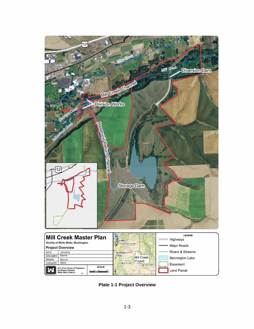
based on changing conditions. The MCMP focuses on overarching management goals and objectives. Details of design, management and administration, and implementation are addressed in another document, the Mill Creek Operational Management Plan (OMP). This 5-year management plan that details information required to implement the concepts described in the MCMP. This Plan does not address regional water quality, water management, or the operation and maintenance of project operations facilities. The MCMP is the result of regional and local needs, resource capabilities and suitability and expressed public interests consistent with authorized project purposes and regulations. The MCMP was last updated in 1993. A revision is warranted due to the age of the existing master plan, changes in Corps policy and guidance regarding Master Plans, and increased visitor use. 1.4 PROJECT DESCRIPTION The Project, constructed by the Corps in 1942, is located along Mill Creek approximately 3.5 miles east of the city of Walla Walla within the Mill Creek watershed (Plate 1-1). It is located completely within Walla Walla County. The project consists of the Mill Creek Channel, Bennington Lake and associated Federal lands. The dam and reservoir portions of the channel and lands are operated and maintained by the Corps. The Project provides flood risk management, recreation, fish and wildlife habitat, and irrigation. Since 1942, nearly $80 million in potential flood damages have been prevented by the project’s combined storage and channel operations.
1-3
Plate 1-1 Project Overview
1-4
1.5 PROJECT RESOURCE USE GOALS Resource goals provide the overall framework guiding the use of resources administered by the Corps at a project site. The goals and objectives in the MCMP are specific to Mill Creek and its individual areas, and specify attainable options for resource development and management. They have been developed through study and analysis of regional needs, expressed public desires, resource capabilities, and resource potential; and are formulated to guide and direct the overall resource management program.
Project Operations.
Continue to safely, effectively, and efficiently provide benefits to the public consistent with the authorized project purpose of providing flood risk management
Natural and Cultural Resources Management. Allow public access and use of Corps-owned land, as appropriate Protect and preserve archeological and historical sites Protect and enhance fish and wildlife habitat Control noxious weeds and other undesirable weed species
Recreation and Interpretation
Provide high quality, safe recreational facilities year-round to a wide segment of the public, including individuals with disabilities
Minimize conflicts between user groups and Corps operational requirements
Coordination. Maintain communication and coordination with appropriate Indian tribes; Federal,
state, and local agencies; and citizen groups and organizations for management of the manmade and natural resources at Mill Creek
1.6 CONCEPTUAL FRAMEWORK Master plan processes encompass a series of interrelated and overlapping tasks involving the examination and analysis of past, present, and future environmental, recreational, and socioeconomic conditions and trends. With a generalized conceptual framework, the process focuses on four primary components: 1) regional and ecosystem needs; 2) project resource capabilities and suitability; 3) expressed public interests that are compatible with the Project’s authorized purposes; and 4) environmentally-sustainable elements. A scoping meeting held March 31, 2015 in support of the master plan update presented the public with opportunities to provide input an ideas. Recommendations received during the scoping meeting helped Corps planners identify opportunities for improved management of project lands. Those recommendations ultimately facilitated the formulation and evaluation of proposed plans.
1-5
Information gathered during the scoping period was combined with the detailed project inventory to form a list of opportunities, constraints, and other influencing factors for future recreation development and management at Mill Creek. Refer to Appendix B for responses from the scoping meetings. From this inventory and input, updated land classifications were developed a final land classification map was created. The new map is used for locating appropriate development and management actions that will be detailed in the Mill Creek Operational Management Plan. Conceptual implementation plans were created by using public input, resource inventory, and the updated land classifications. These plans are designed to guide future management and development of the Mill Creek Project. The intent is to provide public access and recreational opportunities that meet public desire and are compatible with the natural resources stewardship values at the project. Natural Resources staff at Mill Creek will prioritize these plans and implement them in their Operational Management Plan as funding allows. Prior to implementation each recommended action must be reviewed for environmental impact and compliance with the National Environmental Policy Act (NEPA) and the National Historic Preservation Act (NHPA). A list of previous NEPA actions can be found in Appendix C. 1.7 DESIGN MEMORANDUMS The following is a list of Design Memorandums (DM) previously submitted
Title
Cover Date
Mill Creek Master Plan November 1993 Supplement 1 to Design Memorandum 2 May 1965 Master Plan for Mill Creek Reservoir, DM 2 February 1962 Master Plan for Mill Creek Reservoir, DM 1 May 1961
1.8 REFERENCES This master plan was prepared in accordance with the following Corps of Engineers guidance.
Engineer Manual (EM) 1110-1-400, Engineering and Design – Recreation Planning and Design Criteria, 31 July 1987. Engineer Pamphlet (EP) 1105-2-35, Public Involvement and Coordination, 5 February 1982 (Change 1). EP 1130-2-540, Environmental Stewardship Operations and Maintenance Policies, 15 November 1996, revised 11 August 2008. EP 1130-2-550, Project Operations – Recreation Operations and Maintenance Guidance and Procedures, 15 November 1996.
1-6
EP 1130-2-550, Project Operations – Recreation Operations and Maintenance Guidance and Procedures, (Change 5, 30 January 2013). EP 1130-2-500, Project Operations – Partners and Support (Work Management and Support), 27 December 1996. ER 200-1-5, Environmental Quality – Policy for Implementation and Integrated Application of the U.S. Army Corps of Engineers Environmental Operating Principles (EOP) and Doctrine, 30 October 2003. ER 200-2-2, Environmental Quality – Procedures for Implementing the National Environmental Policy Act (NEPA), 4 March 1988. ER 1105-2-100, Planning Guidance, 22 April 2000 (with Appendices D and G revised June 2004 and Appendix F revised January 2006). ER 1120-2-400, Recreation Resource Planning, 1 November 1971 (Changes 1 through 3). ER 1130-2-550, Project Operations – Recreation Operations and Maintenance Guidance and Procedures, 15 November 1996 (Changes 1 through 5). ER 1130-2-550, Project Operations – Recreation Operations and Maintenance Guidance and Procedures, 15 November 1996 (Change 7, 30 January 2013).
2-1
2 PROJECT SETTING AND FACTORS INFLUENCING RESOURCE USE, MANAGEMENT, AND DEVELOPMENT
Section 2 is an overview of the key factors that influence and constrain present and future use, management, and development of land and water resources at the Mill Creek Project. These factors fall into three general and interrelated categories: natural resources, historical and social resources, and administration and policy. An analysis of these factors, as well as regional needs and desires, results in a framework to minimize adverse impacts to the environment and resolve competing and conflicting uses. Information presented in this section is used to designate land classifications, develop project-wide resource objectives, and identify facility needs. 2.1 PROJECT DESCRIPTION The Mill Creek Project is located in Southeastern Washington on Prospect Point Ridge. It lies at the transition between the foothills of the Blue Mountains and the Walla Walla Valley. The project boundary is adjacent to the city of Walla Walla, Washington. Constructed by the US Army Corps of Engineers (Corps), the Mill Creek Project was designed to protect the city of Walla Walla from the flooding of Mill Creek. The project is composed of several components: 1) Mill Creek Dam; 2) off-channel reservoir (Virgil B. Bennington Lake); 3) Mill Creek Channel and levees; 4) diversion facilities (including Bennington Lake Diversion Dam); 5) Division Works and return facilities; 6) fish passage structures; 7) and associated Federal lands.
Mill Creek Dam - The dam is an earth fill structure with a heavy gravel face. The dam is 800 feet wide at the base, 125 feet high, 20 feet wide at the top and 3,200 feet long at the crest.
Virgil B. Bennington Lake - This off-stream reservoir has a maximum storage
capacity of 8,300 acre-feet at water elevation 1,265 feet above mean sea level (msl), with 5 feet of freeboard. The reservoir is the only public lake within 45 miles of the city of Walla Walla.
Mill Creek Channel - About 5,000 feet of the Mill Creek levee channel is Federally-
operated and maintained. The remainder of the channel is owned and operated by the Mill Creek Flood Zone Control District.
Diversion Facilities - The diversion facilities consist of a diversion dike, Bennington
Lake Diversion Dam, debris facilities and intake canal facilities. The dike is a rolled earth fill dam, 1,700 feet long and 20 feet high. Bennington Lake Diversion Dam contains an Ambursen ogee-crest type spillway and outlet. It is 250 feet long and 14 feet high.
2-2
Division Works and Return Facilities - The division works allow water to be divided between Mill Creek, Yellowhawk Creek, and Garrison Creek. The return facilities consist of the outlet works and two outlet canals that are used to return flood waters from Bennington Lake to Mill Creek.
Fish Passage Structures - There are two fish ladders that provide fish passage in
the Mill Creek Channel. In 2001, fish screens were installed at the intake on the diversion structure to prevent trapping fish in Bennington Lake during recreational filling. In 2008, fish screens were installed at the mouth of Garrison Creek to dissuade fish from migrating up Garrison, and encouraging them to use Yellowhawk Creek. Three energy dissipation weirs were modified as prototypes to test efficiency as low-flow passage in 2013.
Lands - 612 acres are Federally-owned and 87 acres are easement lands. This is
the largest public open space in the Walla Walla Valley. These lands provide flood risk management, project operation, recreation, and wildlife benefits. More than 20 miles of recreation trails exist throughout Mill Creek Project lands as well as recreational facilities at Rooks Park, Mill Creek Trail and Bennington Lake Recreation Area. 60 acres were purchased under the Lower Snake River Fish and Wildlife Compensation Plan (LSRFWCP) and transferred to the project as mitigation for lost habitat and hunter opportunity from construction of Lower Snake River dams. Additional wildlife habitat has been developed throughout the project by the Corps, the State of Washington and local volunteers. Visitation during fiscal year 2012 (latest data available) was 302,004.
2.2 HYDROLOGY The Project is located within the Mill Creek watershed, a subbasin of the Walla Walla River watershed. Mill Creek is 37 miles long and drains 165 square miles within the Walla Walla Watershed. Mill Creek originates on the western slopes of the Blue Mountains (5500 ft.). The creek flows through 15 miles of mountainous terrain before it enters the Walla Walla Valley about 2 miles east of the city of Walla Walla. The Mill Creek watershed elevations range from 5,500 feet (at headwaters) to 590 feet (at the mouth of Mill Creek, where it joins the Walla Walla River. The streamflow pattern for Mill Creek consists of moderate to high flows from November through June, and low flows from July through October. When precipitation during the autumn months is low and winter temperatures are below normal, the low flow period may stretch as late as February. Major floods may be caused by any one of the following conditions: 1) intensive rainstorms; 2) a combination of rainfall and snowmelt; or 3) summer “cloudburst” thunderstorms. Winter floods are relatively short in duration, and peak discharges occur in December through February. Mill Creek has had several floods of damaging magnitude. Historically, these floods have usually occurred in the winter, and have primarily been caused by intensive warm rain falling on frozen and snow-covered ground. The largest flood ever recorded
2-3
in the area occurred on 1 April 1931, and had and estimated peak discharge of 6,000 cfs. The spring snowmelt flood period generally extends from March through May. Peak Discharges from spring snowmelt runoff rarely result in severe flooding. The lake is filled for recreational use after the risk of floods has passed. This recreational filling can occur until the 15th of June each year if flows are high enough in Mill Creek. Because runoff is low in the summer and demand for water is high, Mill Creek’s low runoff years critically affect lake levels in the summer. A lower lake level reduces the area available for boating and increases the water temperature, adversely affecting water quality, recreation opportunities, and fisheries. 2.3 TOPOGRAPHY, GEOLOGY, AND SOILS 2.3.1 Topography The project is located on part of the Palouse Section of the Columbia-Snake intermountain Province (C-S Intermountain), in an area that nearly intersects the Blue Mountain Section. The project location was chosen because of its close proximity to Walla Walla, Mill Creek, and the elevation changes that allowed for the construction of the dam. The 250 foot elevation change on the project lands serves as an interesting visual resource to visitors, and an excellent habitat for various species of wildlife. 2.3.2 Geology The oldest rocks at the project are basalts similar to those of the Columbia River Basalt Group. The basalts that form the bedrock of the project are a result of basalt lava flows from the Columbia River Basalt Group. These rocks underlie the entire project, but are exposed only in the southern and eastern portions of the project lands. Overlying the basalt bedrock is a 30 to 160 foot thick sequence of semi consolidated gravel and clay. Loess overlies this conglomerate, and forms the present ground surface. 2.3.3 Soils The majority of the Walla Walla Valley is mantled with deep, loam-textured soil, known as loess. Loess soils make up 70 percent of the project. All of the loess soils at the project have similar engineering properties. Using the Soil Conservations Service (SCS, now Natural Resource Conservation Service or NRCS) method of soil classification, soils within the project boundaries are divided into three series: 1) Athena; 2) Walla Walla; and 3) Yakima series. Also included are existing and possible borrow pits (Bp). Updated data obtained from the United States Department of Agriculture Soil Data Mart (SSURGO, 2011) are shown on Plate 2-1. Table 2-1 and the following paragraphs describe each classification
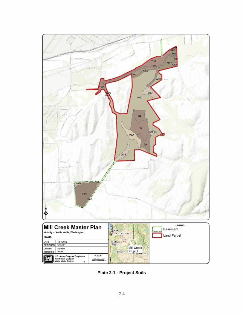
2-4
Plate 2-1 - Project Soils
2-5
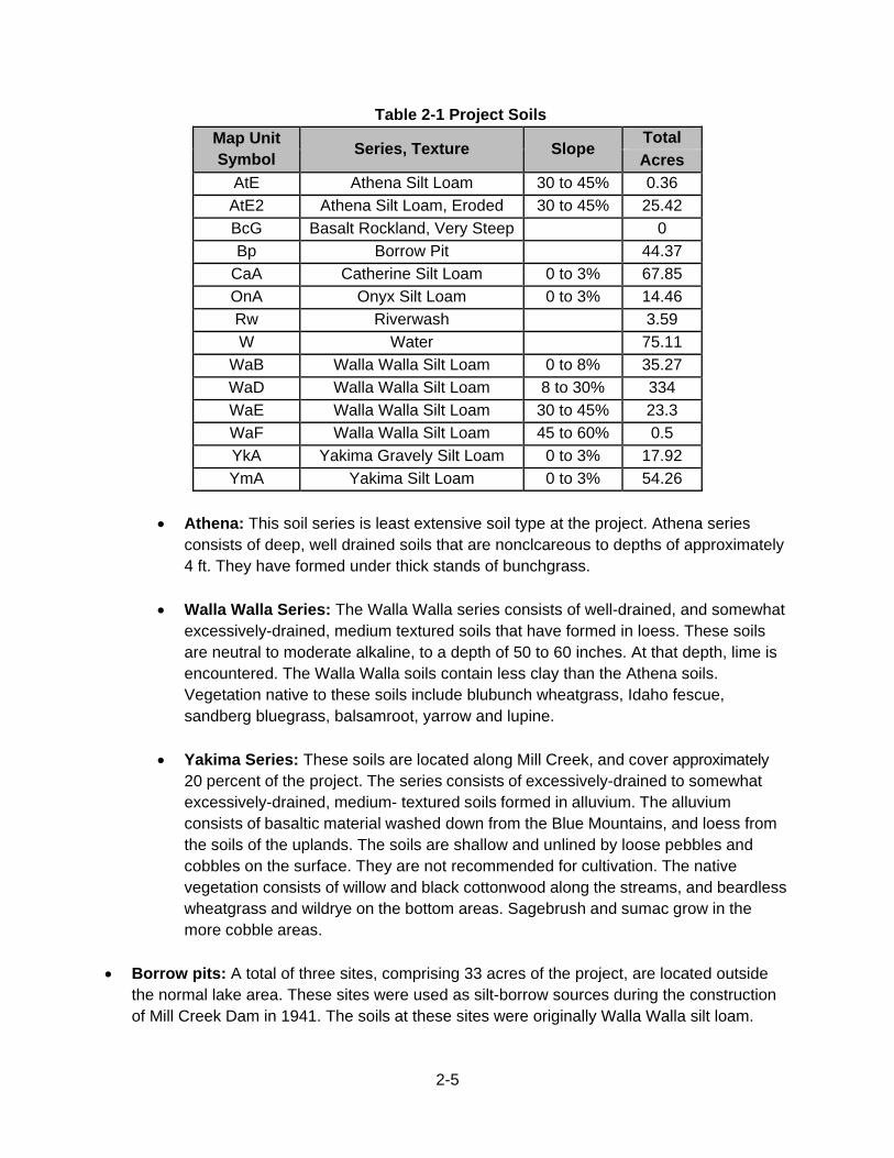
Table 2-1 Project Soils
Map Unit Symbol
Series, Texture Slope Total
Acres
AtE Athena Silt Loam 30 to 45% 0.36
AtE2 Athena Silt Loam, Eroded 30 to 45% 25.42
BcG Basalt Rockland, Very Steep 0
Bp Borrow Pit 44.37
CaA Catherine Silt Loam 0 to 3% 67.85
OnA Onyx Silt Loam 0 to 3% 14.46
Rw Riverwash 3.59
W Water 75.11
WaB Walla Walla Silt Loam 0 to 8% 35.27
WaD Walla Walla Silt Loam 8 to 30% 334
WaE Walla Walla Silt Loam 30 to 45% 23.3
WaF Walla Walla Silt Loam 45 to 60% 0.5
YkA Yakima Gravely Silt Loam 0 to 3% 17.92
YmA Yakima Silt Loam 0 to 3% 54.26
Athena: This soil series is least extensive soil type at the project. Athena series
consists of deep, well drained soils that are nonclcareous to depths of approximately 4 ft. They have formed under thick stands of bunchgrass.
Walla Walla Series: The Walla Walla series consists of well-drained, and somewhat excessively-drained, medium textured soils that have formed in loess. These soils are neutral to moderate alkaline, to a depth of 50 to 60 inches. At that depth, lime is encountered. The Walla Walla soils contain less clay than the Athena soils. Vegetation native to these soils include blubunch wheatgrass, Idaho fescue, sandberg bluegrass, balsamroot, yarrow and lupine.
Yakima Series: These soils are located along Mill Creek, and cover approximately 20 percent of the project. The series consists of excessively-drained to somewhat excessively-drained, medium- textured soils formed in alluvium. The alluvium consists of basaltic material washed down from the Blue Mountains, and loess from the soils of the uplands. The soils are shallow and unlined by loose pebbles and cobbles on the surface. They are not recommended for cultivation. The native vegetation consists of willow and black cottonwood along the streams, and beardless wheatgrass and wildrye on the bottom areas. Sagebrush and sumac grow in the more cobble areas.
Borrow pits: A total of three sites, comprising 33 acres of the project, are located outside the normal lake area. These sites were used as silt-borrow sources during the construction of Mill Creek Dam in 1941. The soils at these sites were originally Walla Walla silt loam.
2-6
2.4 RESOURCE ANALYSIS (Level One Inventory Data) Operational civil works projects administered by USACE are required, with few exceptions, to prepare an inventory of natural resources. The basic inventory required is referred to within USACE regulations (ER and EP 1130-2-540) as a Level One Inventory. This inventory includes the following: vegetation in accordance with the National Vegetation Classification System through the sub-class level; assessment of the potential presence of special status species including but not limited to Federal and state listed endangered and threatened species, migratory species, and birds of conservation concern listed by the U.S. Fish and Wildlife Service (USFWS); land (soils) capability classes in accordance with the Natural Resource Conservation Service (NRCS) criteria; and wetlands in accordance with the USFWS’ Classification of Wetlands and Deepwater Habitats of the United States. This basic inventory information is used in preparing project master plans and OMP. An overview of the natural resources and related management actions at the project is provided in the following sections. 2.4.1 Fish and Wildlife Resources The Project provides fish and wildlife habitat for approximately 170 species close to the city of Walla Walla. This close proximity allows the community to view wildlife for educational, recreational (both passive and consumptive), and aesthetic experiences. The Project supports diverse vegetation. This, in turn, provides a habitat for a wide variety of wildlife. Limited development along the banks of Mill Creek allows it to serve as an important corridor for wildlife from the Blue Mountains to the project. The trees, shrubs, and grasses along the stream above the project provide cover and food for foraging animals. The Rooks Park area, together with small spots of undeveloped private land adjacent to the park, offers a variety of cover for wildlife. Open spaces between these heavily vegetated clusters provide grassy areas, and create an edge effect. Heavy willow growth is predominant in the forebay above Diversion Dam, although it is partially removed periodically to prevent the restriction of flood flows. In these settings, occasional mule and white-tailed deer may be found, along with striped skunk, rabbits, coyote, and bobcat. Numerous birds can also be found here, including the red-shafted flicker, mourning dove, pheasant, quail, and various swallows, sparrows, and thrushes. Hunting is limited to shotgun or archery, because of the project's small size, limited remote areas, and other recreational usage. The rolling land around the lake supports modified Palouse prairie vegetation. Throughout the project’s existence, this area has been co-managed through various agreements with Washington Department of Fish and Wildlife (WDFW) who assisted with developing favorable conditions for the hunting of game birds. The WDFW planted over 5,000 trees and shrubs, as well as native grasses. In the 1980's, the Corps added wildlife plantings, trees and shrubs, pasture, and food plots. In 2010 the Corps added additional tree and shrub plantings, started a mow/spray
2-7
program in order to control invasive broadleaf plants, and started using biological control for mowing of levees and invasive plant control. Coyote, badger, cottontail rabbit, ring-necked pheasant, California quail, and several species of hawks are some of the wildlife species found in these rolling hills. The upper reach of Mill Creek (above the project) provides excellent habitat for rainbow and bull trout as well as good spawning and rearing habitat for steelhead. Headwaters of the upper watershed (23,000 acres) contain some of the highest quality fish habitat in southeastern Washington. Water quality in the upper watershed is excellent primarily because the area is roadless, unlogged, and ungrazed by domestic animals. Bennington Lake serves the valley as a put and take fishery and one of the only public fishing lakes in the Walla Walla Valley. Between 5,000 and 40,000 rainbow trout are planted in the Lake each year by WDFW. As a fishery resource the lake is limited by poor water quality, circulation, and supply, as well as substrate value. The fluctuating water level, caused by dam seepage and evaporation, reduces the lake level during the growing season and hampers establishment of littoral rooted vegetation. Large seasonal fluctuations in water level to accommodate flood storage limit the establishment of resident fish populations and littoral rooted vegetation. The fish habitat in Mill Creek Channel is presently limited by a number of factors, including barriers to upstream migration; habitat degradation and a lack of instream cover and riparian vegetation below Diversion Dam; high temperatures; and low, or zero, flows in the concrete channel (USFWS, 1984). The channel is designed to carry high flows during flood events, and lacks a low-flow channel. Boulders were added in 1986 to mitigate the impacts of flood channel maintenance and enhance fish habitat, but the uniform depth of the channel limits its aquatic value (USACE, 1986). During low-flow periods, the water becomes very shallow and temperatures lethal to salmonids. Channel weirs also limit fish movement during low-flow periods. There are two fish ladders at the project, both of which are in need of modification or replacement to comply with current fish passage criteria. One ladder is located on the right abutment at the First Division Works (RM 10.5), and the other is located upstream at the Mill Creek Diversion Dam (RM 11.5). The channel was originally designed with the authorized purpose of providing flood control. The Corps understands that conditions in the channel are not favorable for resident and migrating fish species. Improvements have and will continue to take place when possible. 2.4.2 Vegetative Resources Major vegetation zones in the region include Shrub-Steppe in the lower elevations, grasslands in mid-elevations, forest in higher elevations of the mountains, and Alpine meadows in the highest elevations. The typical vegetation sequence diagram, found in Table 2-2 lists the various types of vegetation in a conceptual order. There are six potential vegetation types in the region. The vegetation type does not always appear in the order shown below; vegetation may
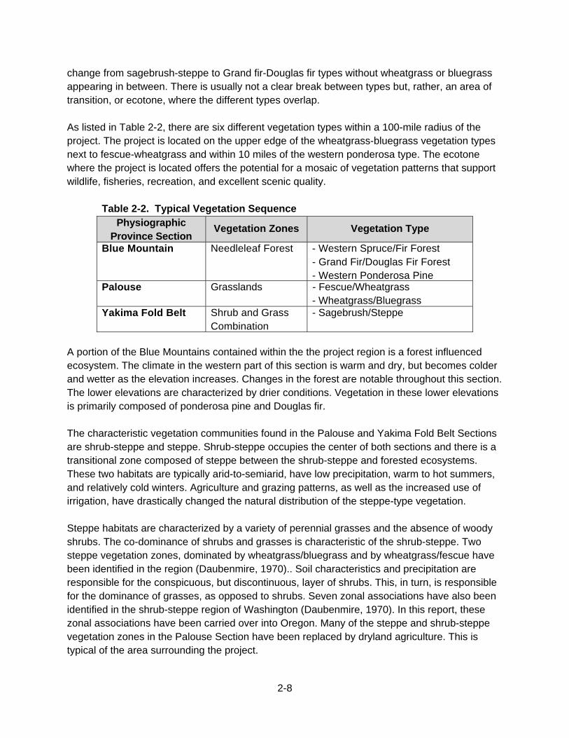
2-8
change from sagebrush-steppe to Grand fir-Douglas fir types without wheatgrass or bluegrass appearing in between. There is usually not a clear break between types but, rather, an area of transition, or ecotone, where the different types overlap. As listed in Table 2-2, there are six different vegetation types within a 100-mile radius of the project. The project is located on the upper edge of the wheatgrass-bluegrass vegetation types next to fescue-wheatgrass and within 10 miles of the western ponderosa type. The ecotone where the project is located offers the potential for a mosaic of vegetation patterns that support wildlife, fisheries, recreation, and excellent scenic quality.
Table 2-2. Typical Vegetation Sequence Physiographic
Province Section Vegetation Zones Vegetation Type
Blue Mountain Needleleaf Forest - Western Spruce/Fir Forest - Grand Fir/Douglas Fir Forest - Western Ponderosa Pine
Palouse Grasslands - Fescue/Wheatgrass - Wheatgrass/Bluegrass
Yakima Fold Belt Shrub and Grass Combination
- Sagebrush/Steppe
A portion of the Blue Mountains contained within the the project region is a forest influenced ecosystem. The climate in the western part of this section is warm and dry, but becomes colder and wetter as the elevation increases. Changes in the forest are notable throughout this section. The lower elevations are characterized by drier conditions. Vegetation in these lower elevations is primarily composed of ponderosa pine and Douglas fir. The characteristic vegetation communities found in the Palouse and Yakima Fold Belt Sections are shrub-steppe and steppe. Shrub-steppe occupies the center of both sections and there is a transitional zone composed of steppe between the shrub-steppe and forested ecosystems. These two habitats are typically arid-to-semiarid, have low precipitation, warm to hot summers, and relatively cold winters. Agriculture and grazing patterns, as well as the increased use of irrigation, have drastically changed the natural distribution of the steppe-type vegetation. Steppe habitats are characterized by a variety of perennial grasses and the absence of woody shrubs. The co-dominance of shrubs and grasses is characteristic of the shrub-steppe. Two steppe vegetation zones, dominated by wheatgrass/bluegrass and by wheatgrass/fescue have been identified in the region (Daubenmire, 1970).. Soil characteristics and precipitation are responsible for the conspicuous, but discontinuous, layer of shrubs. This, in turn, is responsible for the dominance of grasses, as opposed to shrubs. Seven zonal associations have also been identified in the shrub-steppe region of Washington (Daubenmire, 1970). In this report, these zonal associations have been carried over into Oregon. Many of the steppe and shrub-steppe vegetation zones in the Palouse Section have been replaced by dryland agriculture. This is typical of the area surrounding the project.
2-9
Three types of vegetation classes are found within the project; they are, “terrestrial,” “riparian,” and “wetland.” To a large extent, these differences determine wildlife niches, habitats, and associated values. Nearly 70% of the project is classified as upland vegetation, with upland field making up 67% of the project. The remaining portions of the project consist of riparian (7.6%), wetlands (6.7%), lacustrine (7%), riverine (2.1%), and urban (9.2%). The project has a variety of vegetation types in a relatively small area. Some of the vegetation types are made up of monoculture species. Future planting efforts would focus on creating greater species diversity and composition. Irrigated croplands are located in the Valley west of the project. Trees and shrubs have been planted in former croplands in an effort to improve wildlife habitat by providing cover and the interspersion of plant communities.
Previous Planting Work
When the project lands were purchased in the 1940’s, all of the lands south of Mill Creek were used for wheat production. Wildlife management activities at the project were initially conducted by utilizing a cooperative agreement with WDFW. Habitat planting improvements in the 1950s by WDFW provided food and cover for a variety of birds and mammals. WDFW planted approximately 5,000 trees and shrubs, establishing the original meadow, food plot, and tree-shrub plantings. The diversion canal, areas surrounding the lake, Russell Creek Outlet Canal, and the lake road were also planted by the WFDW and the Corps as wildlife areas. Trees planted at this time included Russian olive, Chinese elm, black locust, prune, peach, mugho pine, and juniper. Shrubs planted included carigana, honeysuckle, and serviceberry. Tall wheatgrass and Sherman big bluegrass were also planted. Dodder, thistles, morning glory, and a variety of herbaceous plants grow naturally in the lake area.
2.4.3 Threatened and Endangered Species Federally-listed rare, threatened, and endangered species must be considered in all planning, operations, and management activities in order to reduce the level of ecological degradation within project boundaries. Federally-listed species occurring or potentially occurring near the Project are Middle Columbia River (MCR) Steelhead (O. mykiss), Bull Trout (Salvelinus confluentus), Canada Lynx (Lynx canadensis), Ute ladies’-tresses (Spiranthes diluvialis), Yellow-billed cuckoo (Coccyzus americanus), and the Washington ground squirrel (Urocitellus washingtoni). Each is described in the following paragraphs.
The MCR Steelhead. The MCR steelhead were listed as threatened under the ESA on March 25, 1999 (64 FR 14517), and confirmed as threatened on January 5, 2006 (71 FR 834). Protective regulations for MCR steelhead were issued under section 4(d) of the ESA on June 28, 2005 (70FR 37160). The spawning range for the MCR
2-10
steelhead extend over an area of approximately 35,000 square miles in the Columbia plateau of eastern Washington and eastern Oregon. The MCR steelhead include all naturally-spawning populations of steelhead in streams within the Columbia River basin from above the Wind River in Washington and the Hood River in Oregon (exclusive) upstream to, and including these areas. The MCR steelhead, as defined, do not include the resident form of O. mykiss (rainbow trout) co-occurring with these steelhead (Corps, 2015) and both are managed separately.
The MCR steelhead generally return to the Mill Creek area from December through April. During low flows, some returning fish may avoid the main channel of Mill Creek by migrating up Yellowhawk Creek. The major steelhead spawning area starts just below the area of Kooskooskie, WA (RM 21.5) and continues upstream to the city's water intake structure (RM 25.2). A few spawning areas lie above the intake. Most of the juvenile rearing occurs over a distance of 15 miles; between Diversion Dam and the city's intake structure. After spending two years in the rearing areas, juvenile steelhead outmigrate from October to May, although some may residualize and stay within Mill Creek. Juvenile steelhead do not have difficulty outmigrating from Mill Creek and the Walla Walla River, because these streams normally have adequate flows during the migration timeframe (USFWS, 1984). In 1992, the Corps began maintaining 50 cfs of water in the main channel of Mill Creek (downstream of the project Office) for as long as possible in an effort to further aid the out migrating juvenile steelhead (Corps, 1993).
Bull Trout. The USFWS issued a final rule listing the Columbia River population of
bull trout as a threatened species on June 10, 1998 (63 FR 31647). Bull trout are currently listed throughout their range in the coterminous United States as a threatened species. In the Columbia River Basin, bull trout historically were found in about 60% of the basin. They now occur in less than half of their historic range. Populations remain in portions of Oregon, Washington, Idaho, Montana, and Nevada (Corps, 2015). The Walla Walla River Basin is comprised of five local bull trout populations. Each population in the Walla Walla basin has a resident and migratory (fluvial) component. Fluvial populations migrate to larger streams after a few years in their natal stream while resident bull trout spend their entire lives in or near the stream where they hatched. These resident bull trout complete their entire life cycle in the headwater streams where they spawn and rear. Migratory bull trout spawn in headwater streams along with resident bull trout. Their juveniles rear from one to four years before migrating downstream to mainstem river habitats as subadults. Migratory adult bull trout return to headwater spawning areas in September and October and then migrate downstream to overwintering areas from October through December after spawning. Some adults move out of the Mill Creek Project area generally between May and July. Some juveniles migrate during this period as well. Resident and migratory forms may be found together, and either form may give rise to
2-11
offspring exhibiting either resident or migratory behavior. Both subadult and adult bull trout use the lower Walla Walla River during the fall, winter, and spring for rearing and overwintering (Anglin et al., 2012).
Canada Lynx. The Canada lynx was listed as a threatened species in 2000. In 2003, in response to a court-order to reconsider the listing, USFWS clarified their final listing decision. The current information on resident lynx in Washington identifies populations in the North Cascade Mountains, the Kettle Range, Little Pend Oreille Mountains and the Selkirk Mountains, all in northern Washington (Stinson 2001).
Ute Ladies’-Tresses. Ute ladies’-tresses was listed as threatened in 1992 in its entire range. Within the area covered by this listing, this species is known to occur in Colorado, Idaho, Montana, Nebraska, Utah, Washington, and Wyoming. In 2004, USFWS contracted for a comprehensive status review of this species. A draft of this report became available in February 2005. A final draft of the status review was completed in October 2005.
Western Yellow-Billed Cuckoo. The yellow-billed cuckoo was listed as threatened under the ESA in October 2014. Critical habitat was also proposed for designation at that time, but not in Washington.
Washington Ground Squirrel. The Washington ground squirrel is currently a candidate for listing under the ESA.
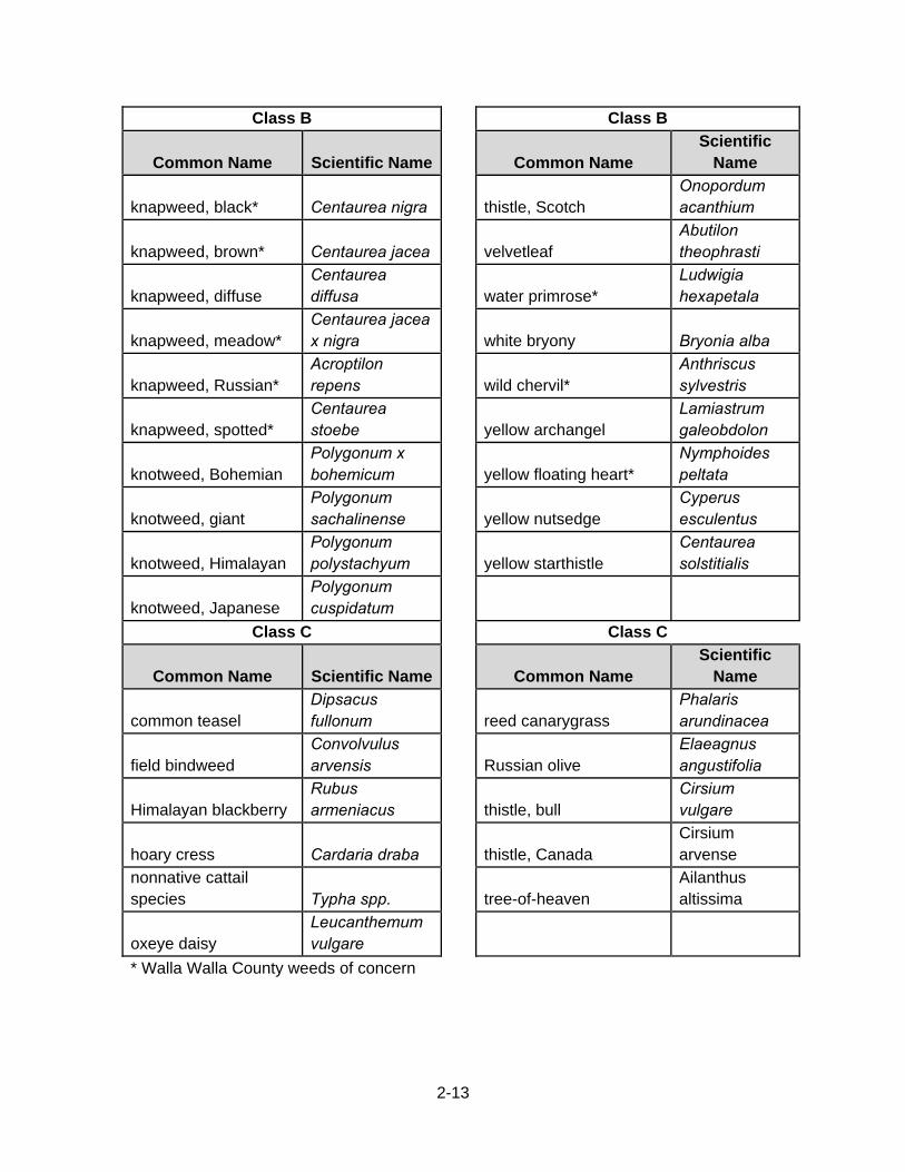
2.4.4 Invasive Species In accordance with Executive Order (EO) 13112, an invasive species is defined as an alien species whose introduction does or is likely to cause economic or environmental harm or harm to human health. Invasive species may be accidentally transported or deliberately introduced because they are thought to be helpful in some way. The following invasive species (see Table 2-3) are listed as Class B and C weeds in Walla Walla County. Class B weeds are non-native species presently limited to portions of the State. Preventing new infestations in these areas is a high priority. In regions where a Class B species is already abundant, control is decided at the local level, with containment as the primary goal. Class C weeds are noxious weeds which are already widespread in Washington. If any of these species are found on project lands appropriate measures will be taken to limit their spread.
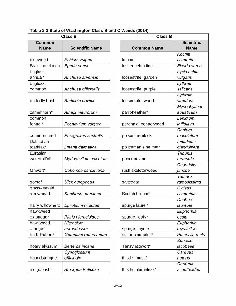
2-12
Table 2-3 State of Washington Class B and C Weeds (2014)
Class B Class B
Common Name Scientific Name Common Name
Scientific Name
blueweed Echium vulgare kochia Kochia scoparia
Brazilian elodea Egeria densa lesser celandine Ficaria verna
bugloss, annual* Anchusa arvensis loosestrife, garden
Lysimachia vulgaris
bugloss, common Anchusa officinalis loosestrife, purple
Lythrum salicaria
butterfly bush Buddleja davidii loosestrife, wand Lythrum virgatum
camelthorn* Alhagi maurorum parrotfeather* Myriophyllum aquaticum
common fennel* Foeniculum vulgare perennial pepperweed*
Lepidium latifolium
common reed Phragmites australis poison hemlock Conium maculatum
Dalmatian toadflax* Linaria dalmatica policeman’s helmet*
Impatiens glandulifera
Eurasian watermilfoil Myriophyllum spicatum puncturevine
Tribulus terrestris
fanwort* Cabomba caroliniana rush skeletonweed Chondrilla juncea
gorse* Ulex europaeus saltcedar Tamarix ramosissima
grass-leaved arrowhead Sagittaria graminea Scotch broom*
Cytisus scoparius
hairy willowherb Epilobium hirsutum spurge laurel* Daphne laureola
hawkweed oxtongue* Picris hieracioides spurge, leafy*
Euphorbia esula
hawkweed, orange*
Hieracium aurantiacum spurge, myrtle
Euphorbia myrsinites
herb-Robert* Geranium robertianum sulfur cinquefoil* Potentilla recta
hoary alyssum Berteroa incana Tansy ragwort* Senecio jacobaea
houndstongue Cynoglossum officinale thistle, musk*
Carduus nutans
indigobush* Amorpha fruticosa thistle, plumeless* Carduus acanthoides
2-13
Class B Class B
Common Name Scientific Name Common Name Scientific
Name
knapweed, black* Centaurea nigra thistle, Scotch Onopordum acanthium
knapweed, brown* Centaurea jacea velvetleaf Abutilon theophrasti
knapweed, diffuse Centaurea diffusa water primrose*
Ludwigia hexapetala
knapweed, meadow* Centaurea jacea x nigra white bryony Bryonia alba
knapweed, Russian* Acroptilon repens wild chervil*
Anthriscus sylvestris
knapweed, spotted* Centaurea stoebe yellow archangel
Lamiastrum galeobdolon
knotweed, Bohemian Polygonum x bohemicum yellow floating heart*
Nymphoides peltata
knotweed, giant Polygonum sachalinense yellow nutsedge
Cyperus esculentus
knotweed, Himalayan Polygonum polystachyum yellow starthistle
Centaurea solstitialis
knotweed, Japanese Polygonum cuspidatum
Class C Class C
Common Name Scientific Name Common Name Scientific
Name
common teasel Dipsacus fullonum reed canarygrass
Phalaris arundinacea
field bindweed Convolvulus arvensis Russian olive
Elaeagnus angustifolia
Himalayan blackberry Rubus armeniacus thistle, bull
Cirsium vulgare
hoary cress Cardaria draba thistle, Canada Cirsium arvense
nonnative cattail species Typha spp. tree-of-heaven
Ailanthus altissima
oxeye daisy Leucanthemum vulgare
* Walla Walla County weeds of concern
2-14
2.4.5 Ecological Setting The Natural Resource Management Mission of the U.S. Army Corps of Engineers (ER 1130-2-550, Chapter 2, Paragraph 2-2.a.(1), dated 15 November 1996) states the following:
The Army Corps of Engineers is the steward of the lands and waters at Corps water resources projects. Its Natural Resource Management Mission is to manage and conserve those natural resources, consistent with ecosystem management principles, while providing quality public outdoor recreation experiences to serve the needs of present and future generations. In all aspects of natural and cultural resources management, the Corps promotes awareness of environmental values and adheres to sound environmental stewardship, protection, compliance and restoration practices. The Corps manages for long-term public access to, and use of, the natural resources in cooperation with other Federal, State, and local agencies as well as the private sector. The Corps integrates the management of diverse natural resource components such as fish, wildlife, forests, wetlands, grasslands, soil, air, and water with the provision of public recreation opportunities. The Corps conserves natural resources and provides public recreation opportunities that contribute to the quality of American life. (ER 1130-2-550 1996)
In support of this mission statement, the following paragraphs describe the ecoregion where Mill Creek is located and the natural resources components found within the project area. Mill Creek and surrounding areas are part of the “Blue Mountains” ecoregion as identified by the Environmental Protection Agency (EPA, 2011) and described below.
Location. Primarily in northeastern Oregon, with small areas extending into southeastern Washington and western Idaho.
Climate. The ecoregion has a severe mid latitude climate, with both continental and Mediterranean influences. It is marked by warm dry summers and cold winters. The
mean annual temperature ranges from approximately -1C to 10C. The frost-free period ranges from 30 to 160 days. As with temperature, the mean annual precipitation ranges widely depending upon elevation, ranging from about 220 mm in low valleys to over 2050 mm at high elevations; 558 mm is the regional mean value.
2-15
Vegetation. At low elevations, grasslands of bluebunch wheatgrass, Idaho fescue, basin big sagebrush, mountain big sagebrush, and juniper woodlands. In forested areas, ponderosa pine, some Douglas-fir, grand fir. At higher elevations, subalpine fir, Engelmann spruce, whitebark pine, and lodgepole pine, with krummholz and alpine meadows in the alpine zone.
Hydrology. Perennial stream density varies by elevation and substrate; some areas with few perennial streams. Some springs are scattered throughout the region. Alpine lakes in high elevation areas. A few large reservoirs. Large rivers that cross the region include the Deschutes and Snake.
Terrain. This ecoregion is distinguished from the neighboring Cascades (6.2.7) and Northern Rockies (6.2.3) ecoregions because the Blue Mountains are generally not as high and are considerably more open. Like the Cascades, but unlike the Northern Rockies, the region is mostly volcanic in origin. Only the few higher ranges, particularly the Wallowa and Elkhorn Mountains, consist of intrusive rocks that rise above the dissected lava surface of the region. Elevations range from 305 m to over 3000 m. Soil temperature regimes are mostly frigid, but include some mesic in warmer areas, and cryic at high elevations. Andisols and Mollisols are common, with mostly xeric and udic soil moisture regimes. Most soils are influenced by volcanic ash deposits.
Wildlife. Rocky Mountain elk, mule deer, black-tailed deer, black bear, bighorn sheep, cougar, bobcat, coyote, beaver, raccoon, golden eagle, chukar, sage thrasher, pileated woodpecker, nuthatches, chickadees, bluebirds, chinook and coho salmon, steelhead/rainbow trout, bull trout, brook trout.
Land Use and Human Activities. Forestry and recreation. Unlike the bulk of the Cascades and Northern Rockies, much of this ecoregion is grazed by cattle. Some public lands. Areas of irrigated agriculture include alfalfa and pasture, winter wheat, potatoes, mint, onions, garlic, and grass seed.
2.4.6 Wetlands Approximately 6.7 percent of the vegetated lands at the project are classified as wetlands. Wetland are classified as Palustrine Open Water (W-OW), Palustrine Emergent (W-PE), Palustrine Scrub Shrub (W-PS), and Palustrine Forest (W-PF).
Palustrine Open Water (W-OW) – This class applies to small, shallow, permanent, or intermittent water bodies (often called ponds). The diversion dam forms a 3 acre area of W-OW on the project. There is also a small area (2/10th of an acre) in Rooks Park (just south of the paved parking lot) that is W-OW. This area was the original Mill Creek Channel, before Mill Creek was channelized in 1941.
2-16
Palustrine Emergent (W-PE) – This type of land cover is dominated by meadow emergent vegetation, with marsh-type emergents appearing in wetter areas. Sixteen and one-half acres of W-PE are located in the forebay area, behind the diversion structure
Palustrine Scrub Shrub (W-PS) – Water-dependent shrubs (primarily willow and red osier dogwood) are dominant in this type of land cover. Ground cover is typically a mixture of emergents similar to those dominating W-PE. Hydric soil is present, but is seasonally flooded. Eleven acres of W- PS are located in the forebay, on the north side of Mill Creek.
Palustrine Forest (W-PF) – This subclass applies to wetlands dominated by trees (primarily black cottonwood) over 20 feet tall. Ground cover, as described in the W-PE and W-PS subclasses, often appears with a sub-canopy of water-dependent shrubs. The east end of the forebay contains 10 acres of W-PF.
2.5 CULTURAL RESOURCES AND CONTEXT Cultural resources (or “historic properties” as defined in the National Historic Preservation Act (NHPA) of 1966, as amended) includes any prehistoric or historic district, site, building, structure, or object included on, or eligible for inclusion on, the National Register, including artifacts, records, and material remains relating to the district, site, building, structure, or object. Factors affecting cultural resources include land status, water resources facilities and operations, recreation facilities, wildlife developments, and project visitation. Typically, determining the significance of resources is the responsibility of properly qualified staff within the Corps. However, regional Tribal groups may also identify a religious or cultural significance to a cultural resource, and effects to this type of significance must also be identified and assessed as part of the planning process. Both regional studies and studies within the boundaries of the project have been used to identify potentially affected cultural resources. Future research will further refine and expand the understanding of important cultural resources. Information regarding cultural resources within the project should be directed to the Corps’ Cultural Resources section, as any actions implemented under the MP are subject to cultural resources review under existing Federal law. Ames et al. (1998) proposes a broad archaeologically based cultural chronology for the Southern Plateau. The region encompasses areas that exhibit continuity in material culture, and extending from the Canadian border to the north, southward to areas within the drainages of the Deschutes and John Day rivers; and from the Cascade Range to the west to the Clearwater River, all of Hells Canyon, and parts of the Salmon River to the east. The cultural chronology is divided into Periods. Period 1, 11500 BP to approximately 4400 BP, is subdivided into two periods. Period 1a (the Paleo-Indian Period) 11,500-11,000 BP is characterized by the presence of large, fluted projectile points used to hunt now extinct mega-fauna. Period 1b is characterized by the remains of a very diverse tool kit, including projectile points, cobble tools, utilized flakes, scrapers, gravers, grooved stones, and cores. Bone tools are also occasionally observed, including needles and awls. Overall, evidence points to broad-spectrum hunter-
2-17
gatherer subsistence patterns characterized by high seasonal and annual mobility, and low population densities. Period 2, 5000/4400-1900 B.C., is not characterized by significant shifts in technology or subsistence strategies, but rather the decreasing frequency and dependency on projectile points for hunting. Semi-subteranean pit houses appear for the first time, and artifact assemblages point to increased utilization of seasonal resources such as roots and salmon. The “pit-houses” are typically circular or rectangular, and 7 to 8 m across, and 1 to 2 m deep. The presence of these houses is generally accepted as evidence of a shift to a pattern of semi-sedentism. This pattern of pithouse structures all but disappears during the period from 2000-1800 B.C. Period 3, 1900 B.C.-A.D. 1720, is marked by the reappearance of the pit-house. This period also continues the trend of seasonally specific resource utilization including roots and salmon, as well as the preservation and storage of these resources. The dimension of houses during this period diversifies, and as this settlement pattern coalesces into the presence of towns and villages, other structural forms such as the community long-house appear. This division proposed by Ames et al. (1998) is further subdivided by Leonhardy and Rice (1970), who propose a cultural chronology for the Snake River Region. The region is further subdivided into geographical districts, with the Lower Monumental District being most relevant to the project APE. Within the Lower Monumental region six archaeological phases are proposed by Leonhardy and Rice (1970). They include the Windust Phase, 8000 B.C. to 7000 B.C; the Cascade Phase, 6000 B.C. to 3000 B.C.; the Tucannon Phase, 3000 B.C. to 500 B.C.; the Harder Phase, 500 B.C. to A.D. 1300; the Piqunin Phase, A.D. 1300 to A.D. 1700; and the ethnographic Numipu Phase, A.D. 1700 to A.D. 1900. These phase generally correspond to regionally unique variations to the broader patterns discussed in Ames et al. (1998) At the time the first European peoples came into contact with Indigenous populations in the vicinity of the Mill Creek Project the predominant groups in the area were the Cayuse, Umatilla, and Walla Walla. The Walla Walla and Umatilla both spoke versions of the Sahaptin dialect, while the Cayuse spoke an extinct traditional dialect closely related to that of the Mollala Indians of the Oregon Cascade Mountains. Although the areas utilized by the different groups would have been varied, the Cayuse are most associated with the immediate project area. Particularly the imćé’me’pu (mortar stone creek people) who resided in the upper Walla Walla River area near present day Milton-Freewater, and the pásxapu (sunflower people) who resided within the middle Walla Walla and along Mill Creek (Stern 1998:395). The horse had made its way north prior to the contact period. The presence of horses was the result of northward trading among Tribes who had acquired the horse from Spanish settlements in the Southwest United States. Horses likely first appeared in the region in the early 1700s. Territorial Governor Isaac I. Stevens estimated that the Umatilla, Cayuse, and Walla Walla tribes had 20,000 horses at the time of the treaty council of 1855. The epidemic diseases brought by the earliest European settlers also often preceded their first contact within the region. Spanish, Russian, British and American trade vessels had all made visits to the Northwest Coast, and introduced epidemic disease that traveled inland (Walker and Sprague 1998:138-141). The earliest well documented European exploration of the area was

2-18
the Lewis and Clark Expedition, which traversed immediately to the north of the current project area heading west in 1805, and again heading east in 1806. Trade in furs is also significant in Northwest history. David Thompson, of the North West Company, led an expedition out of the Rocky Mountains through the Northwest beginning in 1807 and arriving at the mouth of the Columbia River in 1811. He established a series of trading posts during the journey. Fort Nez Perce, a trading outpost established by the North West Company and inherited by the Hudson Bay Company when the two were merged in 1821, is located approximately 32 miles to the west of the current project area at the confluence of the Walla Walla and Columbia rivers. The fur trade dwindled, and by 1846 prices for fur had dropped precipitously and the Hudson Bay Company had begun to expand into other ventures such as grain production, livestock, timber and harvesting of fish. Around this time the Hudson Bay Company also began to withdraw from the Southern Plateau (Walker and Sprague 1998:142-143). The period following the decline of the fur trade is marked by the migration of European-American settlers into the region. Many of these early settlers were intent on establishing missions for the purpose of converting Indian people to Christianity. Dr. Marcus Whitman was a medical doctor and missionary, who along with his wife Narcissus established the Waiilatpu Mission just to the west of present day Walla Walla in 1836. Dr. Whitman along with a small number of families established the mission, which included numerous buildings, a school, a grist mill, and a saw mill (Lyman 1901:41). In the preceding years, by way of correspondence and a return trip to the east, Whitman lobbied for increased migration of settlers to the Oregon Territory. In 1847, after an outbreak of measles, the Indians who had interacted with residents of the Whitman Mission became suspicious of a link between the disease and the doctor’s unsuccessful treatments. This suspicion erupted into violence, leading to the killing of the doctor and his wife, and a number of the other residents of the mission. A handful of escapees, along with others who had been detained at the mission, were eventually able to take refuge at Fort Nez Perce (by then referred to as Fort Walla Walla). The relationship between European-American settlers and the Indigenous populations were exacerbated by the incident at Waiilatpu. The Oregon provisional government raised a volunteer army that carried out retaliations against the Cayuse, Walla Walla, and Umatilla. Returning with, and hanging five Cayuse believed to be responsible for the incident. In reality, the Oregon provisional government was not endorsed by either the Hudson Bay Company, which still operated in the region, or the American Government. The incident, and the resulting campaign against the Indian peoples, eventually forced the hand of the American Government. This led to the official establishment of the Oregon Territory in 1948. One provision of this law was the affirmation of “rights of person or property” of the Indians “so long as such rights shall remain unextinguished by treaty” (Beckham 1998:149). The Washington Territory was established in 1853. Territorial Governor Isaac Stevens of Washington made it a personal mission in 1854 and 1855 to secure the treaties. The foundation of his approach was to acquire the cession of large land areas, and the creation of reservations (Beckham 1998:152). The first major treaty councils east of the Cascades occurred in the vicinity of present day Walla Walla.
2-19
The effort to secure treaties east of the Cascade Mountains commenced in 1855 when Territorial Govern Stevens and Oregon Indian Affairs Superintendent Joel Palmer began their journey through the region. Walla Walla was the site of a large council between a number of Tribes and the territorial government representatives (Beckham 1998:149). The first treaty council occurred in late May and early June of 1855. Large numbers of Nez Perce, Cayuse, Yakama, Umatilla and Walla Walla descended on a spot described by Lyman (1901:61) as the present day location of Whitman College. On June 11th Stevens had secured treaties establishing reservations for the Yakama Nation, the Nez Perce; and collectively, the Umatilla, Cayuse and Walla Walla. These treaties established reservations, and included compensation and the retention of a handful of rights within the former lands. Although the treaties would take on greater meaning through time, they initially were all but ignored. Despite the treaties, trespasses onto reservation land by prospectors and settlers was not controlled, and served to ratchet up tensions between settlers and the resident Tribes. A number of battles soon followed. The one most significant to the immediate area occurred in the vicinity of Frenchtown, and involved fighting between Oregon volunteers and warriors aligned with the Walla Walla Chief Peupeumoxmox. Frenchtown was the largest settlement in the area at the time of the treaty council. According to Lyman (1901:59) there were 85 residents in Frenchtown, with all of the men being Frenchmen and former Hudson Bay Company employees, and all of the women Indian. The Walla Walla leader Peupeumoxmox, who participated in the treaty signing in 1855, was killed during the battle. The battle line moved from west to east before ending after five days of fighting. Much to the protest of Territorial Governor Stevens, Major General Wool of the U.S. Army ordered that no settlers were to be allowed to remain in the Walla Walla Valley except for the former Hudson Bay employees (Lyman 1901:73-74). Stevens made numerous protests to this order, and in 1857 the present day Fort Walla Walla was established. One of its earliest commanders was Lieutenant Colonel Steptoe, who would launch a legendarily unsuccessful campaign north into the territory of the Spokane Indians from Fort Walla Walla. Fort Walla Walla would continue to be a recurring player in battles between the U.S. Army and regional Tribes. The fort was temporarily closed in 1910, but reopened as a WWI artillery training facility. After the first World War it was converted into a Veteran’s Administration Hospital facility (Lindsley 2011:3) Archaeological surveys, largely conducted in accordance with Section 106 of the NHPA, provide insight into resources located in and near the project. These surveys are conducted by professional archaeologists, and done in advance of activities determined to have the potential to affect cultural resources. Numerous investigations have occurred at both the project, and at the adjacent Walla Walla Community College. An Indian burial was recorded on grounds belonging to the WWCC, and sites related to historic settlement of the Walla Walla Valley have been found on and off Corps’ property. Only portions of Corps property at the project have been investigated, and it is likely additional sites will be discovered. Additionally, the Mill Creek Flood Control Project was also evaluated for its historical significance. Facilities associated with the project were determined to be historically significant by the Corps’ Center for Expertise for the Preservation of Historic Buildings and Structures (McCroskey 2009). This means that future changes or alterations to the character defining elements of the Mill Creek Flood Control Project
2-20
will require consultation in accordance with Section 106 of the NHPA, and its implementing regulations 36 CFR Part 800. If consultation concludes that the effects are adverse, then the Corps will have to consult on ways to avoid, minimize, or mitigate those adverse effects. 2.6 RECREATION FACILITIES AND ACTIVITIES The project provides a variety of water-related, and land-based, recreation opportunities. It is expected that the demand for recreation activities in the future will increase. Future recreation activities and increased usage without facility expansion will change the current user experience, and could negatively impact the resources. The advent of new forms of recreation or extensive facility development is severely restricted by the limited amount of project land and water. 2.6.1 General Background Section 4 of the Flood Control Act of 1944 authorized recreational development at the project. From 1942 (when the project was completed) to 1953 there were no recreational facilities at the project. In 1954, when the lake was elevated, held, and stocked with trout by the State of Washington, the project's first major recreation visitation occurred. However, no formal recreational facilities were made available to the public until 1965. The approval of the report Master Plan for Mill Creek Reservoir (DM No. 1), dated 24 May 1961, gave authorization to build and operate the recreational facilities at Rooks Park, which opened to the public in 1965. The next closest non-urban recreation facility from Walla Walla is Lewis and Clark Trail State Park, located on Hwy 12 28 miles away. As recreation facilities were added visitation increased. Visitation continues to increase as facilities and the area's population also increases. Mill Creek Project is one of the most popular recreation locations in the area due to its close proximity to the city of Walla Walla. Visitors use the area heavily for sport fishing on Virgil B. Bennington Lake; hiking, horseback riding, mountain and road biking, walking on the project’s various trails, and birding, picnicking, and sightseeing throughout the project. The project saw over 300,000 visitors in 2012. 2.6.2 Access Vehicular access to Bennington Lake is via Reservoir Road and Rooks Park via Rooks Park Road off of Mill Creek Road. The project has one boat launching ramp, and it extends to elevation 1,188’. The far side of the lake is accessible by 1.6 miles of trail. This trail uses the upper portion of Dam Service Road, as well as East Service Road Currently, pedestrian access to the project is provided by the Mill Creek Recreation Trail. The trail begins at Cambridge Drive and is connected to existing bike routes that run through the city of Walla Walla. From Cambridge Drive, the Mill Creek Recreation Trail runs along the north side
2-21
of Mill Creek for almost 1 mile. It crosses Tausick Way, and continues along the Walla Walla Community College campus until it reaches the Federal project boundary across from the project office. From there, it continues through the project for another 1 .1 mile, until it reaches Rooks Park Road. 2.6.3 Recreation Use
Water-Based Recreation
Boating on Virgil B. Bennington Lake is limited to paddling, rowing, or electric-motor-powered vessels (i.e. boats with electric trolling motors, canoes, rafts). This policy protects the lake from unwanted pollutants associated with gasoline motors and provides maximum space for vessels compatible with the lake’s size. The majority of boat use at the lake is associated with fishing. Boating at Virgil B. Bennington Lake is at capacity during peak periods. Restrictions are determined by the limited number of water surface acres. Addition of ADA accessible shoreline trails will improve the facility for visitor enjoyment. Fishing for stocked rainbow trout is a major recreational activity of visitors to Virgil B. Bennington Lake. Trout are planted each year by the WDFW for angler harvest. There is approximately 2 miles of shoreline around Virgil B. Bennington Lake when it is at elevation 1,205. Approximately 50 percent of the shoreline is unusable, or is not used, due to poor access, slope, or vegetation. The boat ramp allows for users to launch their boats (non internal combustion engines only) all year long. A formal swimming area does not exist at Virgil B. Bennington Lake. Swimming occurs informally primarily because of a lack of viable alternatives. Swimming is not currently promoted due to the lack of support facilities (i.e., a swimming beach that conforms to safety design criteria, changing rooms, sun shelters, and shoreline access trails). Additionally, water quality in the lake can be unsuitable for swimming at certain times (e.g., high fecal coliform counts that do not conform to beach water quality standards). Use of the shoreline needs to be directed away from the boat ramp, where swimming and wading traditionally occurs because of easier access. Access along other areas of the lake is limited by steep slopes or distance from the parking areas
2-22
Hunting
Hunting is permitted on the project in designated areas (See Plate 6-1 on page 6-2 for current hunting boundaries). There are very few public hunting areas within the Walla Walla Valley and Mill Creek provides easy access to hunters of all ages during a limited hunting season (September 1 thru January 31). Several comments were received during the public scoping process regarding public safety issues related to hunting. Multiple user groups utilize the project that is constrained by its small footprint. User conflicts are inevitable and challenging for project staff. Recommendations for managing hunting and user conflicts are discussed in further detail in Section 6 - Special Topics.
Picnicking
Picnic tables and shelters are located throughout the project. There are also designated day use areas that people can use for picnicking. Overall, the picnic facilities meet the current demand under normal use, though some areas may require updating in the future. Additional picnic shelters may be added to meet future demand.
Trails
The project provides more than 20 miles of recreation trials (Table 2-4) that offer scenic views and wildlife watching opportunities throughout the Mill Creek Dam and Bennington Lake area. Trails surfaces vary from pavement, gravel or dirt. In 2012, The Department of the Interior designated the trail system on the south side of Mill Creek and around Bennington Lake as a National Recreation Trail. The trails around the lake meander through open grasslands and wooded areas set against a backdrop of the Blue Mountains. Two trails exist along the mill creek channel that are designed as levee maintenance roads but are allowed for use as trails. The south-shore trail consists of well compacted gravel. The north-shore trail offers a paved surface which extends along Mill Creek into the City of Walla Walla. Visitors use the trails in many different ways such as, walking, horseback riding, and biking. Trail users requested more signage and wayfinding during the public scoping meeting. Currently, few permanent trail markers exist along project trails. Implementing such elements would improve the user experience. Signage improvements along the trail should not detract from the natural setting of the project.
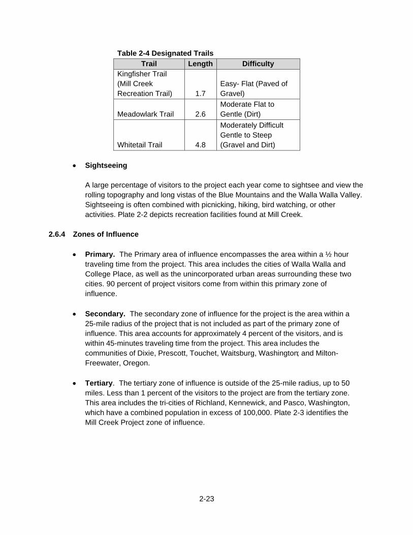
2-23
Table 2-4 Designated Trails
Trail Length Difficulty Kingfisher Trail (Mill Creek Recreation Trail) 1.7
Easy- Flat (Paved of Gravel)
Meadowlark Trail 2.6 Moderate Flat to Gentle (Dirt)
Whitetail Trail 4.8
Moderately Difficult Gentle to Steep (Gravel and Dirt)
Sightseeing
A large percentage of visitors to the project each year come to sightsee and view the rolling topography and long vistas of the Blue Mountains and the Walla Walla Valley. Sightseeing is often combined with picnicking, hiking, bird watching, or other activities. Plate 2-2 depicts recreation facilities found at Mill Creek.
2.6.4 Zones of Influence
Primary. The Primary area of influence encompasses the area within a ½ hour traveling time from the project. This area includes the cities of Walla Walla and College Place, as well as the unincorporated urban areas surrounding these two cities. 90 percent of project visitors come from within this primary zone of influence.
Secondary. The secondary zone of influence for the project is the area within a 25-mile radius of the project that is not included as part of the primary zone of influence. This area accounts for approximately 4 percent of the visitors, and is within 45-minutes traveling time from the project. This area includes the communities of Dixie, Prescott, Touchet, Waitsburg, Washington; and Milton-Freewater, Oregon.
Tertiary. The tertiary zone of influence is outside of the 25-mile radius, up to 50 miles. Less than 1 percent of the visitors to the project are from the tertiary zone. This area includes the tri-cities of Richland, Kennewick, and Pasco, Washington, which have a combined population in excess of 100,000. Plate 2-3 identifies the Mill Creek Project zone of influence.
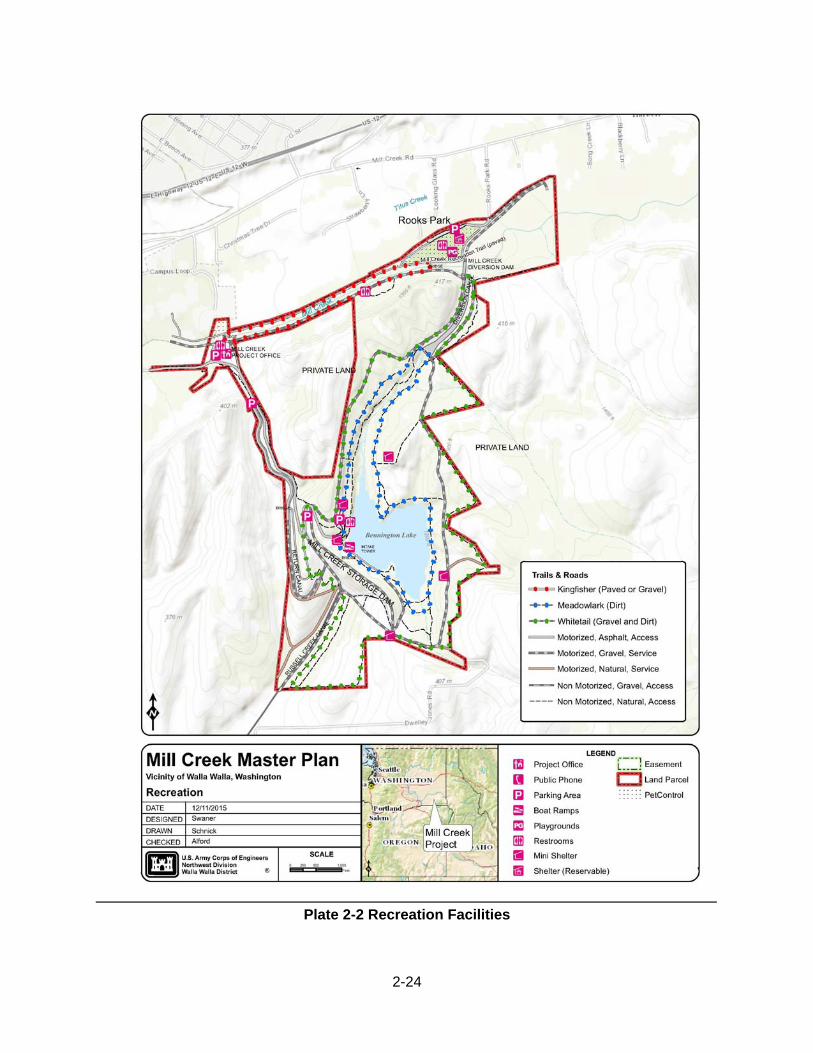
2-24
Plate 2-2 Recreation Facilities
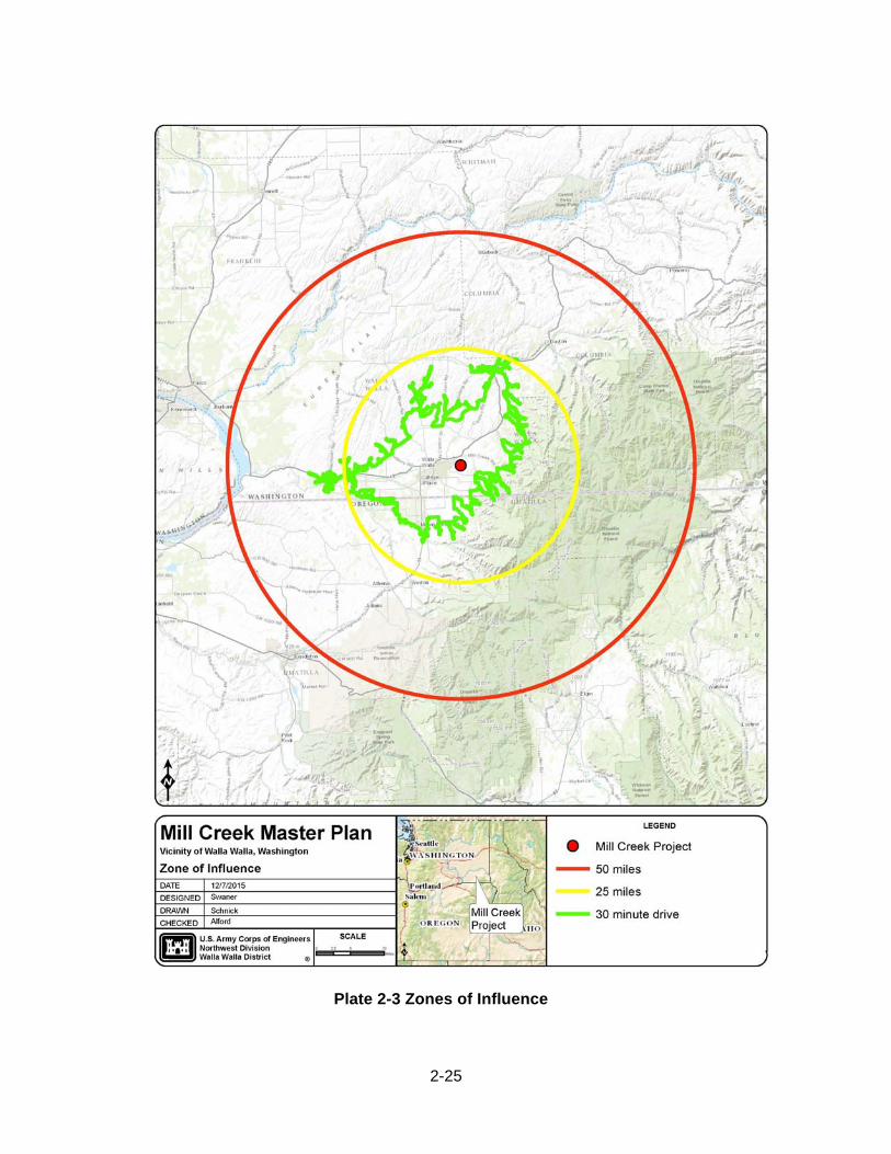
2-25
Plate 2-3 Zones of Influence
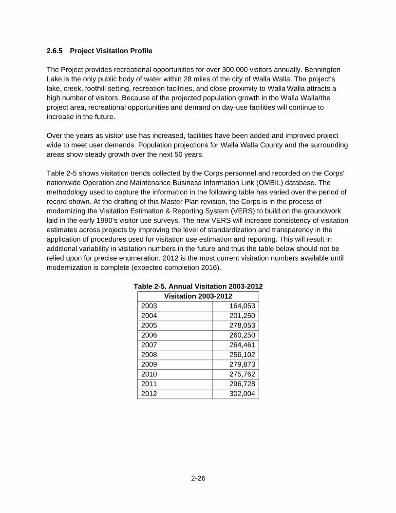
2-26
2.6.5 Project Visitation Profile The Project provides recreational opportunities for over 300,000 visitors annually. Bennington Lake is the only public body of water within 28 miles of the city of Walla Walla. The project's lake, creek, foothill setting, recreation facilities, and close proximity to Walla Walla attracts a high number of visitors. Because of the projected population growth in the Walla Walla/the project area, recreational opportunities and demand on day-use facilities will continue to increase in the future. Over the years as visitor use has increased, facilities have been added and improved project wide to meet user demands. Population projections for Walla Walla County and the surrounding areas show steady growth over the next 50 years. Table 2-5 shows visitation trends collected by the Corps personnel and recorded on the Corps’ nationwide Operation and Maintenance Business Information Link (OMBIL) database. The methodology used to capture the information in the following table has varied over the period of record shown. At the drafting of this Master Plan revision, the Corps is in the process of modernizing the Visitation Estimation & Reporting System (VERS) to build on the groundwork laid in the early 1990’s visitor use surveys. The new VERS will increase consistency of visitation estimates across projects by improving the level of standardization and transparency in the application of procedures used for visitation use estimation and reporting. This will result in additional variability in visitation numbers in the future and thus the table below should not be relied upon for precise enumeration. 2012 is the most current visitation numbers available until modernization is complete (expected completion 2016).
Table 2-5. Annual Visitation 2003-2012 Visitation 2003-2012
2003 164,0532004 201,2502005 278,0532006 260,2502007 264,4612008 256,1022009 279,8732010 275,7622011 296,7282012 302,004
2-27
2.6.6 Recreation Analysis The Statewide Comprehensive Outdoor Recreation Plan (SCORP) 2013 is statewide report that is an integral part of capturing the history and popular activities to enhance recreation opportunities in Washington. It serves as a management tool to help decision-makers and providers better understand and prioritize the use of recreational resources statewide. The SCORP is used by the Corps to better understand and adapt to the current and future recreation trends and needs specific to the State of Washington.
Washington SCORP Data (2013-2018)
The Washington SCORP identified the current rate of participation among state residents within each of the 16 activity categories listed below in Figure 2-1. Not surprisingly, low-cost activities, easy or less strenuous activities, or activities that can be done close to home have relatively high participation rates; this includes walking at the top, with a 90% participation rate among Washington residents, but also near the top are recreational activities (which include jogging), nature activities, and picnicking/BBQing. Conversely, more specialized activities, those with high equipment demands, or those that require extensive travel have lower rates, with the very specialized categories like horseback riding and off highway vehicle use for recreation having the lowest participation rates.
Along with walking and hiking, other core interests involve access to water (swimming, boating), or common leisure time gatherings (picnics and camping). People often use developed trails for activities, especially for bicycling, walking, hiking or nature viewing and photography. Activities with the highest average number of days of participation specifically among those who participate in the activity are walking without a pet and aerobics/fitness activities. Participants like to do these activities several times a week. The highest participation rates overall are for picnicking, BBQing or cooking out, walking without a pet, observing or photographing wildlife, sightseeing, gardening, hiking, and walking with a pet. The most intensive users of public facilities and lands are participants in hiking, picnicking/BBQing/ cooking out, wildlife viewing, and swimming in pools or natural waters. Some activities have had a marked increase in ranking since the previous SCORP, including visiting a nature interpretive center, climbing or mountaineering, firearms use (hunting or shooting), inner tubing or floating, and camping in a primitive location. It is also worth noting that picnicking/BBQing/cooking out went from the ninth-ranked activity in 2002 to the top-ranked activity in 2012. There has been a dramatic increase in participation in many nature-based activities and notable declines in participation in team-based activities.
2-28
Figure 2-1 Outdoor Recreation Participation Rates by Category
Source: Washington SCORP (2013-2018)
The public participated in the SCORP planning process through an Advisory Group, Advisory Group meetings open to the public, an online SCORP Town Hall, and a large scale telephone survey. The SCORP evaluates recreation supply and demand on a statewide basis but also includes a regional analysis. The survey focused on Washington resident’s participation in recreation, their future needs for recreation, their satisfaction or dissatisfaction with outdoor recreation facilities and opportunities, their issues of concern, and any constraints they had in participating in outdoor recreation in Washington.
2-29
Washington SCORP Findings
Participation and Satisfaction – Survey results and associated trends point to an increase in nature-based activities. A major focus on recreation planning over the next 5 years should be in providing these nature-based activities for Washington residents and maintaining the integrity of the ecosystems upon which these recreational activities depend. The majority of Washington outdoor recreationists are quite satisfied, with a few small exceptions. In general, dissatisfaction is low for most activities. Nonetheless, the following activities have dissatisfaction rates of at least 20%: shooting opportunities, disc golf opportunities, off-roading facilities and opportunities, and hunting facilities and opportunities. Providers should be aware of those opportunities with which residents are dissatisfied and continue efforts to develop new facilities or to improve existing facilities and opportunities. Recreation Types – An overwhelming majority of residents are participating in activities that fall under the broad active recreation categories of “walking, hiking, climbing, and mountain biking” (90% of residents participated in activities under this category) and “recreational activities” (83%), which include activities such as swimming, aerobics, jogging, and running. Findings show that the mean of providers‘ answers regarding the percent of their facilities that support active recreation statewide is 54.04% (a B score on the Level of Service). Washington residents participate in a wide variety of outdoor recreation activities. Offering diverse opportunities is important in meeting the demands of underrepresented populations, such as urban residents and minorities. Recreation Sites and Facilities - Facility capacity measures the percent of demand met by existing facilities, and it appears to be the biggest gap that recreation providers feel. In other words, there is the perception among recreation providers that there is an unmet demand pressure that they are unable to address. Findings from the SCORP indicate that 16% of residents said that there were problems with facilities for outdoor recreation in their community. The top problems include a need for more facilities/more availability (35%), poor state of facilities (21%), restricted access (13%), difficulty with access (4%), and broken equipment/poor maintenance (4%)—all items that pertain directly or tangentially to facility capacity. Level of Service scores show that the highest priorities for planning for and improving outdoor recreation in Washington are facilities capacity and quantity. Sustainability - When discussing sustainable recreation, it is important to realize that there are two primary and inter-related factors of sustainable recreation: (1) longevity of environmental resources and assets and (2) the longevity of recreational planning and funding. Environmental sustainability focuses on providing recreation designed to minimize environmental impacts and encourage stewardship and ethical use. Recreational sustainability focuses on providing recreation facilities and opportunities that are designed to maximize the useful life of the facilities and
2-30
opportunities into the future, thereby encouraging self-supporting design, maintenance, operation, and funding. The second factor is dependent on the first: The longevity of recreation planning cannot be ensured without the preservation of the resource itself. Recreationists are interested in sustainability of the natural environment as part of recreation management, to the degree that they are willing to forego additional recreation opportunities to ensure the sustainability of the resources. Recreation providers should work toward getting recreationists involved through volunteer opportunities supporting environmental sustainability and stewardship initiatives. User Conflicts - User conflicts are the result of the interplay between several factors, including activity style, resource specificity, mode of experience, and lifestyle tolerance. An example of user conflict would be the tension between a quiet, fast mountain biker coming into contact on a blind curve with horses that can have an instinctive fear response. Conflict management should continue to be an explicit effort for recreation providers using the tools they already apply such as advisory groups, and resident participation. User groups should meet to work out how cooperative sharing can evolve across the array of recreation activities where there are perceived conflicts, perhaps beginning with collaboration among stakeholder groups and the recreation industry to prepare and promote a program of best recreation-use practices (i.e., norms of behavior) their users can follow to improve inter-group relationships in the field. There was interest among SCORP contributors in zoning to address incompatible recreation activities and sequestering days to separate conflicting dual use (e.g., motorcycles on odd days, mountain bikers on even days) on the same trail. This is an important consideration, especially where speed-of-use and noise conflicts exist between motorized recreation and non-motorized recreation (e.g., ATVs versus mountain bikes) or even between wheeled recreation and non-wheeled recreation (e.g., mountain bikes versus hikers). Research has shown that this can work. In Washington, a study of user conflict between mountain bikers and other users explored the outcomes of a trial period in which mountain bikers were allowed access to the recreation site on odd-numbered calendar days. The study showed that recreationists “felt safe, had a high level of enjoyment, experienced positive interactions with other trail users, and favored the every-other-day policy over closing or opening the trail full time to mountain bikes.” For a copy of the entire Washington SCORP it can be found at: http://www.rco.wa.gov/recreation/scorp.shtml
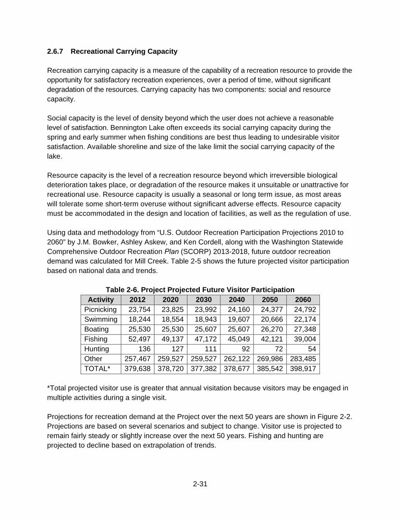
2-31
2.6.7 Recreational Carrying Capacity Recreation carrying capacity is a measure of the capability of a recreation resource to provide the opportunity for satisfactory recreation experiences, over a period of time, without significant degradation of the resources. Carrying capacity has two components: social and resource capacity. Social capacity is the level of density beyond which the user does not achieve a reasonable level of satisfaction. Bennington Lake often exceeds its social carrying capacity during the spring and early summer when fishing conditions are best thus leading to undesirable visitor satisfaction. Available shoreline and size of the lake limit the social carrying capacity of the lake. Resource capacity is the level of a recreation resource beyond which irreversible biological deterioration takes place, or degradation of the resource makes it unsuitable or unattractive for recreational use. Resource capacity is usually a seasonal or long term issue, as most areas will tolerate some short-term overuse without significant adverse effects. Resource capacity must be accommodated in the design and location of facilities, as well as the regulation of use. Using data and methodology from “U.S. Outdoor Recreation Participation Projections 2010 to 2060” by J.M. Bowker, Ashley Askew, and Ken Cordell, along with the Washington Statewide Comprehensive Outdoor Recreation Plan (SCORP) 2013-2018, future outdoor recreation demand was calculated for Mill Creek. Table 2-5 shows the future projected visitor participation based on national data and trends.
Table 2-6. Project Projected Future Visitor Participation Activity 2012 2020 2030 2040 2050 2060
Picnicking 23,754 23,825 23,992 24,160 24,377 24,792 Swimming 18,244 18,554 18,943 19,607 20,666 22,174 Boating 25,530 25,530 25,607 25,607 26,270 27,348 Fishing 52,497 49,137 47,172 45,049 42,121 39,004 Hunting 136 127 111 92 72 54 Other 257,467 259,527 259,527 262,122 269,986 283,485 TOTAL* 379,638 378,720 377,382 378,677 385,542 398,917
*Total projected visitor use is greater that annual visitation because visitors may be engaged in multiple activities during a single visit. Projections for recreation demand at the Project over the next 50 years are shown in Figure 2-2. Projections are based on several scenarios and subject to change. Visitor use is projected to remain fairly steady or slightly increase over the next 50 years. Fishing and hunting are projected to decline based on extrapolation of trends.
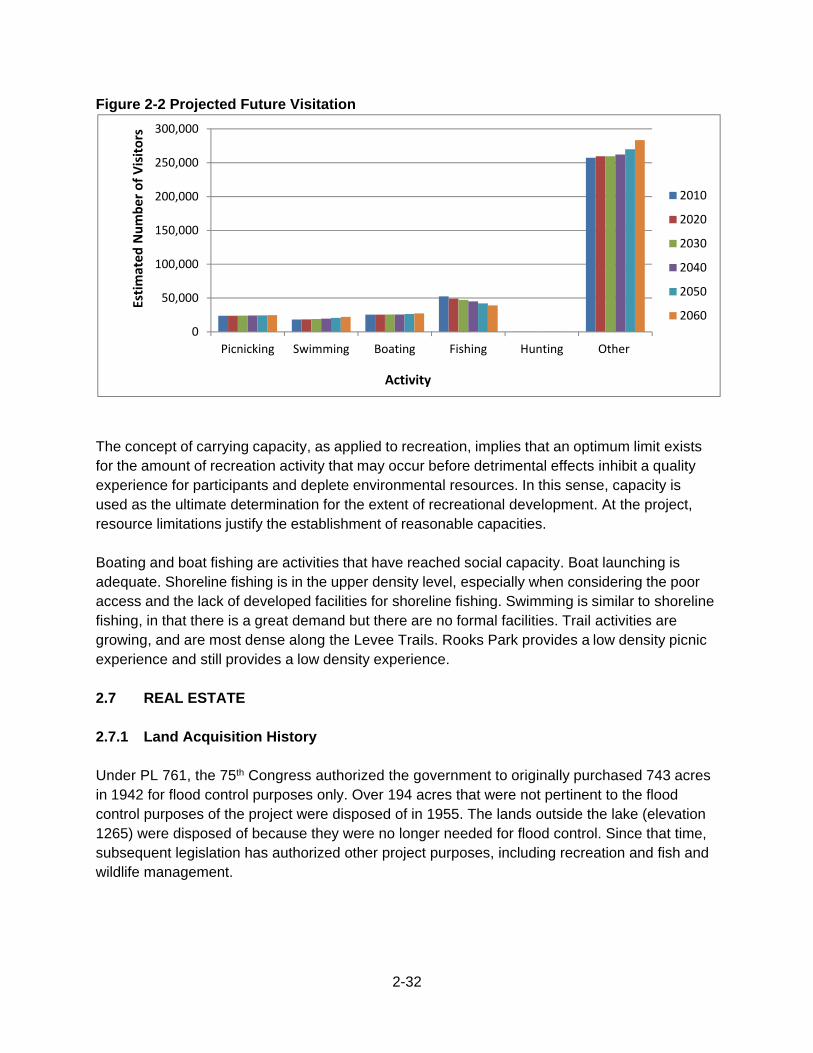
2-32
Figure 2-2 Projected Future Visitation
The concept of carrying capacity, as applied to recreation, implies that an optimum limit exists for the amount of recreation activity that may occur before detrimental effects inhibit a quality experience for participants and deplete environmental resources. In this sense, capacity is used as the ultimate determination for the extent of recreational development. At the project, resource limitations justify the establishment of reasonable capacities. Boating and boat fishing are activities that have reached social capacity. Boat launching is adequate. Shoreline fishing is in the upper density level, especially when considering the poor access and the lack of developed facilities for shoreline fishing. Swimming is similar to shoreline fishing, in that there is a great demand but there are no formal facilities. Trail activities are growing, and are most dense along the Levee Trails. Rooks Park provides a low density picnic experience and still provides a low density experience. 2.7 REAL ESTATE 2.7.1 Land Acquisition History Under PL 761, the 75th Congress authorized the government to originally purchased 743 acres in 1942 for flood control purposes only. Over 194 acres that were not pertinent to the flood control purposes of the project were disposed of in 1955. The lands outside the lake (elevation 1265) were disposed of because they were no longer needed for flood control. Since that time, subsequent legislation has authorized other project purposes, including recreation and fish and wildlife management.
0
50,000
100,000
150,000
200,000
250,000
300,000
Picnicking Swimming Boating Fishing Hunting Other
2010
2020
2030
2040
2050
2060
Activity
EstimatedNumber of Visitors
2-33
The U.S. Government currently owns 611.46 acres within the project boundary, and has easements and reservation rights on 87.27 acres. The majority of the project lands are centered around Virgil B. Bennington Lake, with lands paralleling Mill Creek, and Reservoir Road/Bennington Lake Road. The corps has management rights and responsibilities on these U.S. Government owned lands. Under the LSRFWCP 63.07 acres were purchased and transferred to the project as mitigation for lost habitat and hunter opportunity from construction of Lower Snake River dams. 2.7.2 Leases, Easements, and Outgrants The purpose of an outgrant is to allow other agencies or individuals use of project lands. These outgrants are issued by easement, permit, license, or lease. They are issued if the land is available, and if the proposed use is consistent with operational needs and resource management objectives. Other outgrants may be issued and existing ones terminated or amended, as circumstances warrant. There are currently 8 easements and 1 permit on project lands. The Real Estate Division of the Corps, Walla Walla District maintains all current information on outgrants and reservations. 2.8 PERTINENT PUBLIC LAWS, REGULATIONS, AND POLICIES Rules and regulations governing the public use of water resources development projects administered by the Corps are contained in Title 36, Part 327 of the Code of Federal Regulations. Other authorities specifically related to the management of recreation and public access are found in Public Laws; Executive Orders (EO); and the Corps’ Engineer Regulations (ER), Engineer Manuals (EM), and Engineer Pamphlets (EP). A list of applicable laws applicable to recreation and public access is included in Appendix D. A list of applicable Federal statutes is included in Appendix E. Treaties between the United States and regional mid-Columbia/Lower Snake River Tribes document agreements reached between the Federal government and the Tribes. In exchange for Native American Tribes ceding much of their ancestral land, the government established reservation lands and guaranteed that it would respect the treaty rights, including fishing and hunting rights. These treaties as well as statutes, regulations, and national policy statements originating from the executive branch of the Federal Government provide direction to Federal agencies on how to formulate relations with Native American tribes and people. Treaties with area tribes (e.g. Treaty of June 9, 1855, Walla Walla, Cayuse, Etc., 12 Stat. 945 (1859)) explicitly reserved unto the tribes certain rights, including the exclusive right to take fish in streams running through or bordering reservations, the right to take fish at all usual and accustomed places in common with citizens of the territory, and the right of erecting temporary buildings for curing, together with the privilege of hunting, gathering roots and berries, and pasturing their horses and cattle upon open unclaimed lands. These reserved rights include the right to fish within identified geographical areas.
2-34
2.9 ENVIRONMENTAL CONSIDERATIONS This Plan will evaluate the impacts of land use classification changes and set conditions and parameters for future development. Implementation of each recommended recreation facility and development, as detailed in Mill Creek’s OMP, requires separate environmental compliance evaluations. Appendix I contain a list of the major Federal laws and Executive Orders that may be applicable to implementation of recommendations in this plan.
3-1
3. RESOURCE OBJECTIVES
Resource Objectives are clearly written statements that respond to identified issues and that specify measurable and attainable activities for resource development and/or management of the lands and waters under jurisdiction of the Walla Walla District, Mill Creek Project. The objectives stated in this Master Plan support the goals of the Master Plan, Environmental Operating Principles (EOPs) (Appendix F), and applicable national performance measures. They are consistent with authorized project purposes, Federal laws and directives, regional needs, resource capabilities, and take public input into consideration. Recreational and natural resources carrying capacities are also accounted for during development of the objectives found in this Master Plan. They are developed with full consideration of the project’s authorized purposes; applicable Federal laws and directives; resource capabilities; regional needs; recreational and natural resources carrying capacity; State Comprehensive Outdoor Recreation Plans; cultural and natural resources significant to regional Tribes; and public input. Resource objectives are divided into three categories—General, Environmental Stewardship, and Recreation—to better address specific management needs. 3.1. GENERAL 3.1.1 Project Operations Objective: Continue to safely and efficiently operate and maintain the project to provide flood risk management to the city of Walla Walla and surrounding areas as authorized in public law. Discussion: The project will continue to operate for flood risk management, as authorized by Federal Law and as described in Flood Control Manual-Mill Creek Flood Control Project, in cooperation with the Mill Creek Flood Control Zone District (Walla Walla County). The operation for flood risk management will take into consideration other project resources (wildlife, recreation, etc.), while still meeting the needs for flood risk management. 3.1.2 Boundary Management Objective: Prevent unintentional trespass and negative impacts associated with encroachments (e.g., livestock, agricultural, and vehicular) on government property. Discussion: Continued efforts in surveying, marking, and posting of Operating Project boundary, sharing data with adjacent land owners, public education, and enforcement will help prevent unintentional trespass on Federal lands.
3-2
3.1.3 Safety & Accessibility Objective: Provide use areas and facilities that are safe and accessible for all project visitors. Discussion: Developed areas designated for recreation use will be evaluated regularly for safety and accessibility. Any conditions that have been determined unsafe will be evaluated and feasible corrective actions will be implemented in accordance with EM 385-1-1. When developing new, or rehabilitating existing recreation facilities/opportunities, effort should be made to comply with reasonable ADA accommodations. In addition, special emphasis should be placed on programs that increase participation in outdoor activities for people with physical, developmental, and sensory disabilities. 3.1.4 Aesthetic Resources Objective: Plan all management actions with consideration given to landscape quality and aesthetics. Discussion: Corps regulations and guidance requires that the Corps consider and provide an aesthetically-pleasing environment for the public. Visitors are attracted to the vistas, rolling topography, and water bodies that create high visual quality at the project. In order to create a quality recreation experience it is important that planned improvements be designed and maintained so that visual resources associated with the project will be protected, preserved and maintained to the maximum extent possible. 3.1.5 Facilities Management Objective: Ensure all current and future facilities are maintained and meet Federal and State design standards. Discussion: All new or remodeled facilities will meet current standards. Upgrade and replacement of existing facilities will comply with Corps policy. 3.2 RECREATION 3.2.1 Interpretive Services and Outreach Program (ISOP) Objective: Interpretive services will focus on Agency, District, and Operating Project Missions, benefits and opportunities. Interpretive services at the project will be used to help enhance public safety through promoting public awareness, understanding, and appreciation of the project and its resources. Improve signage and wayfinding throughout the project, specifically along the trail system.
3-3
Discussion: The Mill Creek ISOP includes the management of public affairs, community relations, marketing, publications, tourism, special events, and a visitor center. The project will provide community outreach through interpretive displays and programs at the visitor center, day use areas, community organizations, Chamber of Commerce, press releases, etc. Interpretive displays and programs should highlight on several of the following subjects.
The Corps Land use classifications Operating Project authorized purposes and public benefits Impacts of the Operating Project (historical, cultural, ecological) Historical and traditional uses of the area by regional tribes Operating Project benefits to the nation, region, and local community Recreation opportunities Wildlife and fish associated with the Operating Project lands, waters, and
opportunities to passively and actively utilize Water Safety Ongoing management activities Challenges and possible solutions
Opportunities exist to partner with local Tribes and other groups in the development of these displays and programs. 3.2.2 Day Use Recreation Facilities Objective: Maintain and improve existing day use recreation facilities and lands, as well as develop new facilities to meet public demand and reduce operations and maintenance costs while maintaining the integrity of the Operating Project natural resources. Discussion: Day use activities are the primary recreational use at the project. The project serves approximately 300,000 visitors each year, with 90 percent of these visitors coming from the Walla Walla Valley. Day use activities include but are not limited to: walking, horseback riding, off-leash dog walking, fishing, sightseeing, boating, picnicking, and cycling. Facilities should focus on safe easy access to the lake, adequate parking, picnic sites, and staffed information Visitor Center. In order to meet current and future needs the following facilities may be added to the project:
Restroom upgrades Picnic Shelters Swimming beach ADA access to Bennington Lake Fishing Pier at Bennington Lake Splash Pad
3-4
3.2.3 Dispersed Low Density Recreation Objective: Appropriately manage and provide opportunities and facilities for multiple user groups in low density dispersed recreation areas. Discussion: Close proximity of the project to the City of Walla Walla fills a regional need for natural and semi-natural dispersed recreation. Continuing efforts to provide dispersed recreation at the project will allow visitors to participate in activities such as fishing, upland game bird hunting (in approved areas), nature study, bird watching, cycling, horseback riding, and other activities. Managing user expectations and developing creative solutions in low density recreation areas will remain important as visitor use continues to increase. 3.3 ENVIRONMENTAL STEWARDSHIP 3.3.1 Riparian and Wetland Protection Objective: Protect and limit impacts to wetlands and riparian corridors on the project in conjunction with meeting the needs of maintaining flood damage reduction mission of the project, water quality, and fish and wildlife benefits. Discussion: Wetlands and riparian habitat are of high ecological importance to the Walla Walla Valley. No unnecessary removal or alteration of the systems will be promoted. 3.3.2 Fish and Wildlife Habitat Management Objective: Conserve, protect, restore, and/or enhance habitat and habitat components important to the survival of threatened, endangered, special status, and other regionally important species on Operating Project lands. Discussion: Over the last 60 years improvements have been made to enhance fish and wildlife habitat. Maintenance of future and existing habitats is critical in order to sustain a healthy ecosystem for now and in the future. The Mill Creek Vegetation Planting Strategy has identified future opportunities for planting on projects lands to support fish and wildlife. Any future development should be designed and constructed to minimize negative impacts to these habitats. Under the provisions of Section 7 of the ESA of 1973 and Fish and Wildlife Coordination Act of 1958, actions that may affect endangered or threatened species of their habitat must be coordinated with the USFWS and the National Marine Fisheries Service (NMFS).
3-5
3.3.3 Cultural Resources Management Objective: Protect, preserve, and maintain cultural resources on project lands. Discussion: If any significant historical site is found, the District Archaeologist will be notified and will initiate appropriate action. 3.3.4 Invasive Species Management Objective: Minimize negative impacts to native flora and fauna by reducing and/or eradicating invasive species on Operating Projects lands. Discussion: Reducing and restricting the spread of invasive species will be achieved by monitoring, assessment, and treatment efforts that include an Integrated Pest Management (IPM) approach, chemical, mechanical, and planting with native and culturally significant plant species.
4-1
4. LAND ALLOCATION, LAND CLASSIFICATION, AND PROJECT EASEMENT LANDS
4.1. GENERAL Mill Creek Project was originally constructed for flood control. Recreation was added as a project purpose resulting primarily from the impoundment of water and presence of public land. Management of recreational resources must not conflict with the operations of the project for which it was authorized. The land classification of an area governs land uses, resource management activities, and permissible facility development. Combined with project-wide and site-specific resource objectives, the land use plan provides a conceptual guide for the use, management, and development of all project lands. Together, these elements are the foundation of the Master Plan. 4.2. LAND ALLOCATION Lands are allocated by the congressionally-authorized purposes for which the project lands were acquired. Chapter 3 of EP 1130-2-550 defines these categories as Operations, Recreation, Fish and Wildlife, and Mitigation.
Project Operations. These are lands acquired for the congressionally authorized purpose of constructing and operating the Federal project for the purpose of flood control.
Mitigation. These are lands acquired or designated specifically for the
congressionally authorized purpose of offsetting losses associated with development of the project.
Recreation, Fish, and Wildlife. These are lands acquired specifically for the
purpose of recreation and managing or protecting fish and wildlife. No lands were purchased for these purposes.
4.3. LAND CLASSIFICATIONS Land classification designates the primary use for which project lands are managed. Project lands are zoned for development and resource management consistent with authorized project purposes and the provisions of the NEPA and other Federal laws. Land classifications established in Engineer Pamphlet 1130-2-550 include Project Operations, High Density Recreation, Mitigation, Environmentally Sensitive Areas, Multiple Resource Management Land, and Water Surface. Management and use of the lands assigned to each land classification are discussed, in connection with the appropriate resource objectives, in the following paragraphs. Proposed Project land classifications are shown on Plate 4-1 at the end of this section.
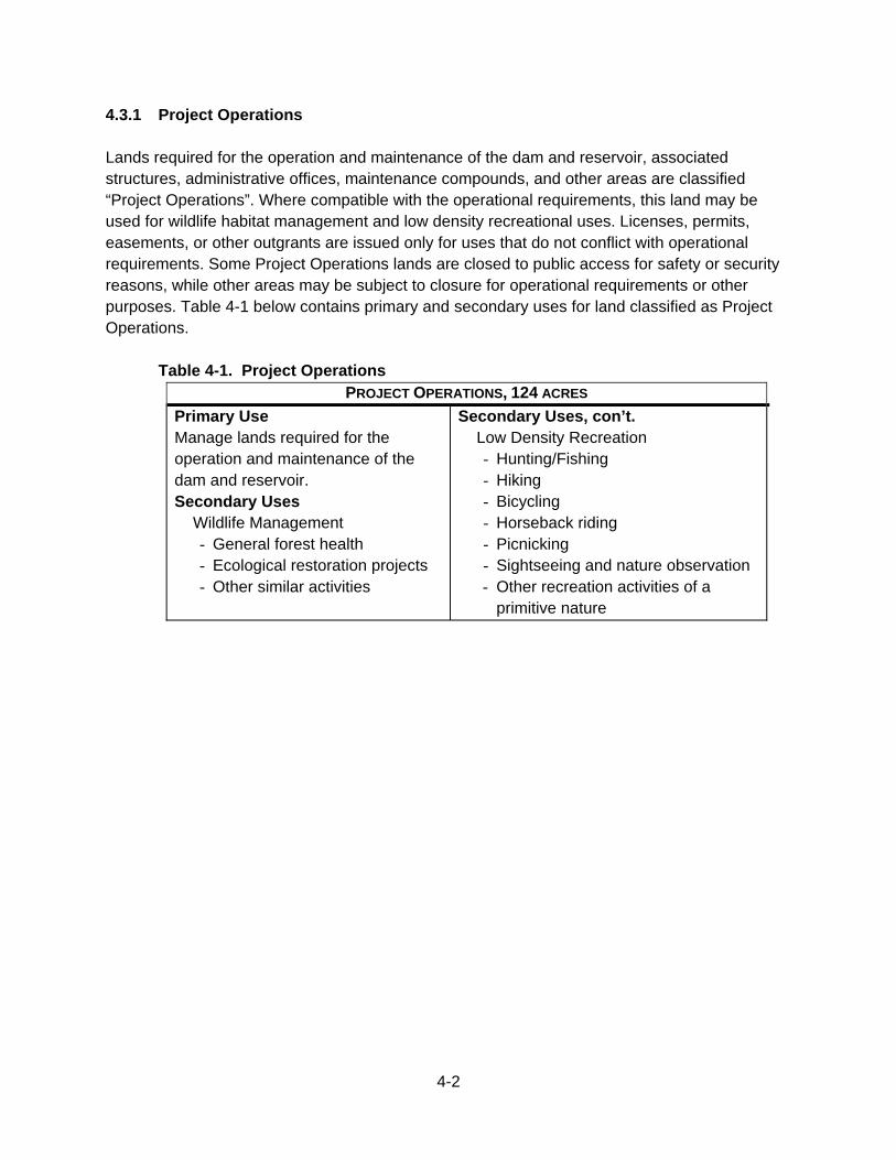
4-2
4.3.1 Project Operations Lands required for the operation and maintenance of the dam and reservoir, associated structures, administrative offices, maintenance compounds, and other areas are classified “Project Operations”. Where compatible with the operational requirements, this land may be used for wildlife habitat management and low density recreational uses. Licenses, permits, easements, or other outgrants are issued only for uses that do not conflict with operational requirements. Some Project Operations lands are closed to public access for safety or security reasons, while other areas may be subject to closure for operational requirements or other purposes. Table 4-1 below contains primary and secondary uses for land classified as Project Operations.
Table 4-1. Project Operations PROJECT OPERATIONS, 124 ACRES
Primary Use Manage lands required for the operation and maintenance of the dam and reservoir. Secondary Uses
Wildlife Management - General forest health - Ecological restoration projects - Other similar activities
Secondary Uses, con’t. Low Density Recreation - Hunting/Fishing - Hiking - Bicycling - Horseback riding - Picnicking - Sightseeing and nature observation - Other recreation activities of a
primitive nature
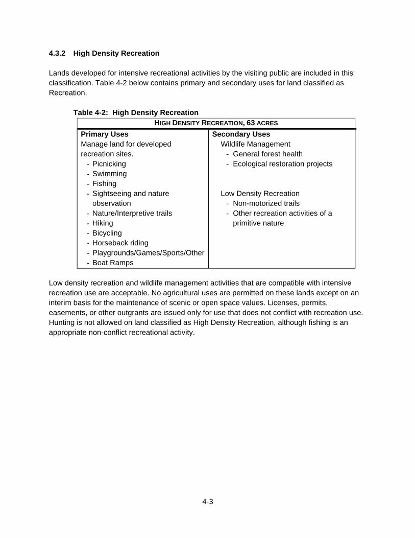
4-3
4.3.2 High Density Recreation Lands developed for intensive recreational activities by the visiting public are included in this classification. Table 4-2 below contains primary and secondary uses for land classified as Recreation.
Table 4-2: High Density Recreation HIGH DENSITY RECREATION, 63 ACRES
Primary Uses Manage land for developed recreation sites.
- Picnicking - Swimming - Fishing - Sightseeing and nature
observation - Nature/Interpretive trails - Hiking - Bicycling - Horseback riding - Playgrounds/Games/Sports/Other- Boat Ramps
Secondary Uses Wildlife Management
- General forest health - Ecological restoration projects
Low Density Recreation - Non-motorized trails - Other recreation activities of a
primitive nature
Low density recreation and wildlife management activities that are compatible with intensive recreation use are acceptable. No agricultural uses are permitted on these lands except on an interim basis for the maintenance of scenic or open space values. Licenses, permits, easements, or other outgrants are issued only for use that does not conflict with recreation use. Hunting is not allowed on land classified as High Density Recreation, although fishing is an appropriate non-conflict recreational activity.
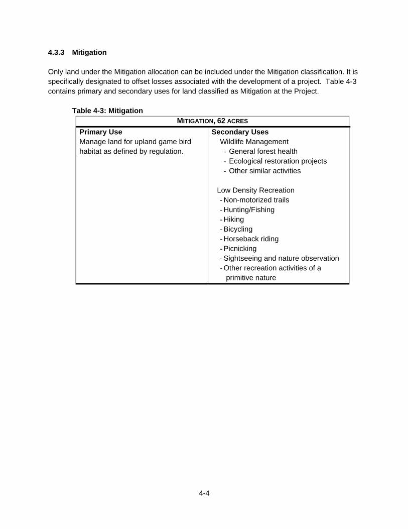
4-4
4.3.3 Mitigation Only land under the Mitigation allocation can be included under the Mitigation classification. It is specifically designated to offset losses associated with the development of a project. Table 4-3 contains primary and secondary uses for land classified as Mitigation at the Project.
Table 4-3: Mitigation MITIGATION, 62 ACRES
Primary Use Manage land for upland game bird habitat as defined by regulation.
Secondary Uses Wildlife Management - General forest health - Ecological restoration projects - Other similar activities
Low Density Recreation - Non-motorized trails - Hunting/Fishing - Hiking - Bicycling - Horseback riding - Picnicking - Sightseeing and nature observation - Other recreation activities of a
primitive nature
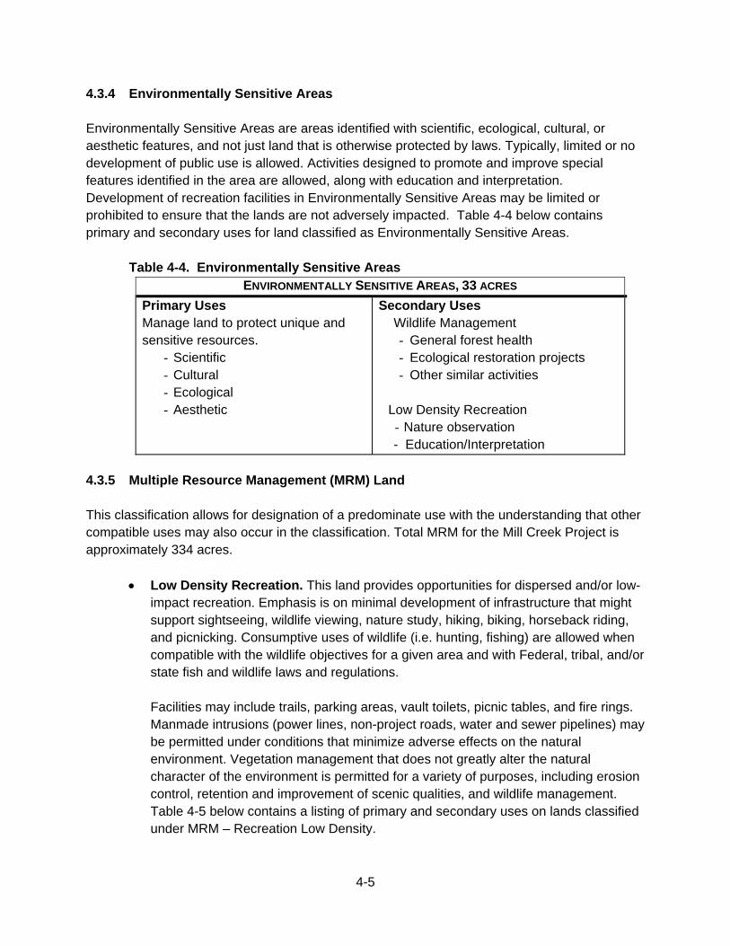
4-5
4.3.4 Environmentally Sensitive Areas Environmentally Sensitive Areas are areas identified with scientific, ecological, cultural, or aesthetic features, and not just land that is otherwise protected by laws. Typically, limited or no development of public use is allowed. Activities designed to promote and improve special features identified in the area are allowed, along with education and interpretation. Development of recreation facilities in Environmentally Sensitive Areas may be limited or prohibited to ensure that the lands are not adversely impacted. Table 4-4 below contains primary and secondary uses for land classified as Environmentally Sensitive Areas.
Table 4-4. Environmentally Sensitive Areas ENVIRONMENTALLY SENSITIVE AREAS, 33 ACRES
Primary Uses Manage land to protect unique and sensitive resources.
- Scientific - Cultural - Ecological - Aesthetic
Secondary Uses Wildlife Management - General forest health - Ecological restoration projects - Other similar activities
Low Density Recreation - Nature observation - Education/Interpretation
4.3.5 Multiple Resource Management (MRM) Land This classification allows for designation of a predominate use with the understanding that other compatible uses may also occur in the classification. Total MRM for the Mill Creek Project is approximately 334 acres.
Low Density Recreation. This land provides opportunities for dispersed and/or low-impact recreation. Emphasis is on minimal development of infrastructure that might support sightseeing, wildlife viewing, nature study, hiking, biking, horseback riding, and picnicking. Consumptive uses of wildlife (i.e. hunting, fishing) are allowed when compatible with the wildlife objectives for a given area and with Federal, tribal, and/or state fish and wildlife laws and regulations.
Facilities may include trails, parking areas, vault toilets, picnic tables, and fire rings. Manmade intrusions (power lines, non-project roads, water and sewer pipelines) may be permitted under conditions that minimize adverse effects on the natural environment. Vegetation management that does not greatly alter the natural character of the environment is permitted for a variety of purposes, including erosion control, retention and improvement of scenic qualities, and wildlife management. Table 4-5 below contains a listing of primary and secondary uses on lands classified under MRM – Recreation Low Density.
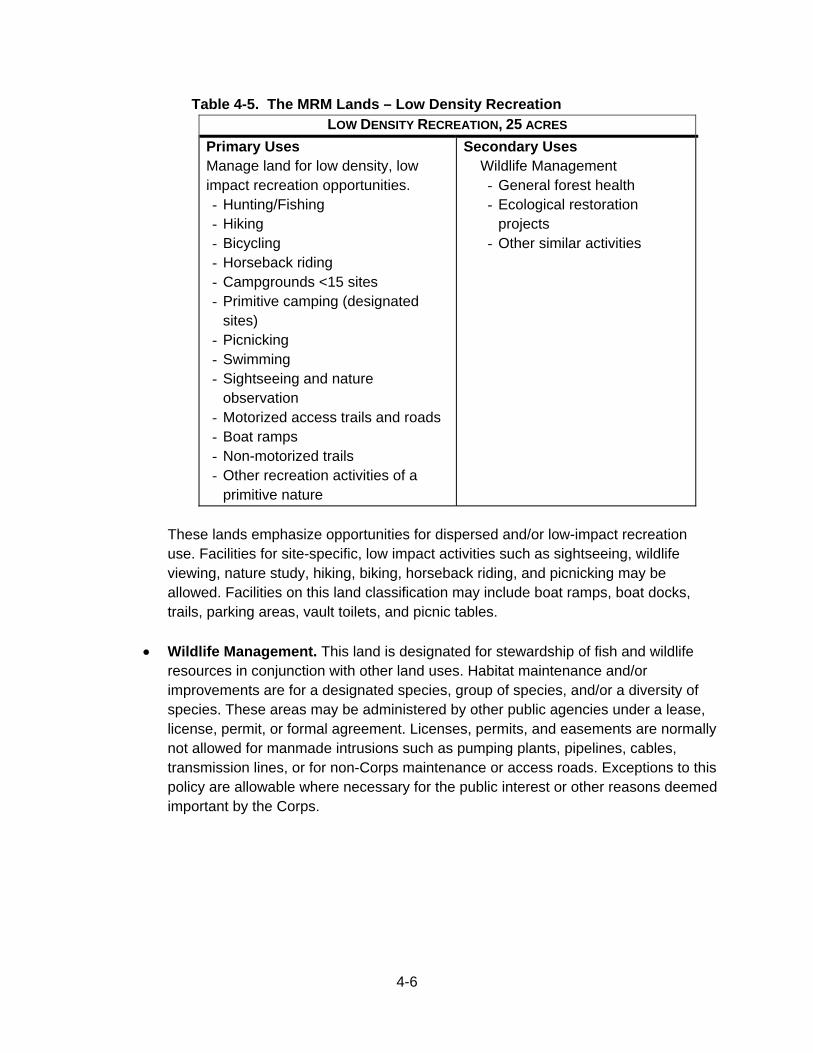
4-6
Table 4-5. The MRM Lands – Low Density Recreation LOW DENSITY RECREATION, 25 ACRES
Primary Uses Manage land for low density, low impact recreation opportunities. - Hunting/Fishing - Hiking - Bicycling - Horseback riding - Campgrounds <15 sites - Primitive camping (designated
sites) - Picnicking - Swimming - Sightseeing and nature
observation - Motorized access trails and roads - Boat ramps - Non-motorized trails - Other recreation activities of a
primitive nature
Secondary Uses Wildlife Management - General forest health - Ecological restoration
projects - Other similar activities
These lands emphasize opportunities for dispersed and/or low-impact recreation use. Facilities for site-specific, low impact activities such as sightseeing, wildlife viewing, nature study, hiking, biking, horseback riding, and picnicking may be allowed. Facilities on this land classification may include boat ramps, boat docks, trails, parking areas, vault toilets, and picnic tables.
Wildlife Management. This land is designated for stewardship of fish and wildlife
resources in conjunction with other land uses. Habitat maintenance and/or improvements are for a designated species, group of species, and/or a diversity of species. These areas may be administered by other public agencies under a lease, license, permit, or formal agreement. Licenses, permits, and easements are normally not allowed for manmade intrusions such as pumping plants, pipelines, cables, transmission lines, or for non-Corps maintenance or access roads. Exceptions to this policy are allowable where necessary for the public interest or other reasons deemed important by the Corps.
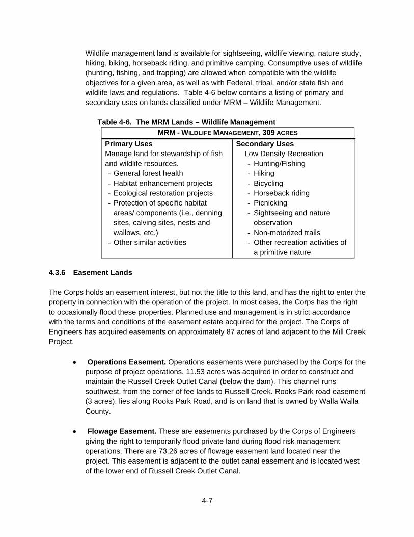
4-7
Wildlife management land is available for sightseeing, wildlife viewing, nature study, hiking, biking, horseback riding, and primitive camping. Consumptive uses of wildlife (hunting, fishing, and trapping) are allowed when compatible with the wildlife objectives for a given area, as well as with Federal, tribal, and/or state fish and wildlife laws and regulations. Table 4-6 below contains a listing of primary and secondary uses on lands classified under MRM – Wildlife Management.
Table 4-6. The MRM Lands – Wildlife Management MRM - WILDLIFE MANAGEMENT, 309 ACRES
Primary Uses Manage land for stewardship of fish and wildlife resources. - General forest health - Habitat enhancement projects - Ecological restoration projects - Protection of specific habitat
areas/ components (i.e., denning sites, calving sites, nests and wallows, etc.)
- Other similar activities
Secondary Uses Low Density Recreation - Hunting/Fishing - Hiking - Bicycling - Horseback riding - Picnicking - Sightseeing and nature
observation - Non-motorized trails - Other recreation activities of
a primitive nature
4.3.6 Easement Lands The Corps holds an easement interest, but not the title to this land, and has the right to enter the property in connection with the operation of the project. In most cases, the Corps has the right to occasionally flood these properties. Planned use and management is in strict accordance with the terms and conditions of the easement estate acquired for the project. The Corps of Engineers has acquired easements on approximately 87 acres of land adjacent to the Mill Creek Project.
Operations Easement. Operations easements were purchased by the Corps for the purpose of project operations. 11.53 acres was acquired in order to construct and maintain the Russell Creek Outlet Canal (below the dam). This channel runs southwest, from the corner of fee lands to Russell Creek. Rooks Park road easement (3 acres), lies along Rooks Park Road, and is on land that is owned by Walla Walla County.
Flowage Easement. These are easements purchased by the Corps of Engineers giving the right to temporarily flood private land during flood risk management operations. There are 73.26 acres of flowage easement land located near the project. This easement is adjacent to the outlet canal easement and is located west of the lower end of Russell Creek Outlet Canal.
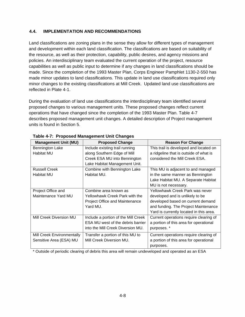
4-8
4.4. IMPLEMENTATION AND RECOMMENDATIONS Land classifications are zoning plans in the sense they allow for different types of management and development within each land classification. The classifications are based on suitability of the resource, as well as their protection, capability, public desires, and agency missions and policies. An interdisciplinary team evaluated the current operation of the project, resource capabilities as well as public input to determine if any changes in land classifications should be made. Since the completion of the 1993 Master Plan, Corps Engineer Pamphlet 1130-2-550 has made minor updates to land classifications. This update in land use classifications required only minor changes to the existing classifications at Mill Creek. Updated land use classifications are reflected in Plate 4-1. During the evaluation of land use classifications the interdisciplinary team identified several proposed changes to various management units. These proposed changes reflect current operations that have changed since the completion of the 1993 Master Plan. Table 4-7 describes proposed management unit changes. A detailed description of Project management units is found in Section 5.
Table 4-7: Proposed Management Unit Changes Management Unit (MU) Proposed Change Reason For Change
Bennington Lake Habitat MU
Include existing trail running along Southern Edge of Mill Creek ESA MU into Bennington Lake Habitat Management Unit.
This trail is developed and located on a ridgeline that is outside of what is considered the Mill Creek ESA.
Russell Creek Habitat MU
Combine with Bennington Lake Habitat MU.
This MU is adjacent to and managed in the same manner as Bennington Lake Habitat MU. A Separate Habitat MU is not necessary.
Project Office and Maintenance Yard MU
Combine area known as Yellowhawk Creek Park with the Project Office and Maintenance Yard MU.
Yellowhawk Creek Park was never developed and is unlikely to be developed based on current demand and funding. The Project Maintenance Yard is currently located in this area.
Mill Creek Diversion MU Include a portion of the Mill Creek ESA MU west of the debris barrier into the Mill Creek Diversion MU.
Current operations require clearing of a portion of this area for operational purposes. *
Mill Creek Environmentally Sensitive Area (ESA) MU
Transfer a portion of this MU to Mill Creek Diversion MU.
Current operations require clearing of a portion of this area for operational purposes.
* Outside of periodic clearing of debris this area will remain undeveloped and operated as an ESA

4-9
Plate 4-1 Land Classification
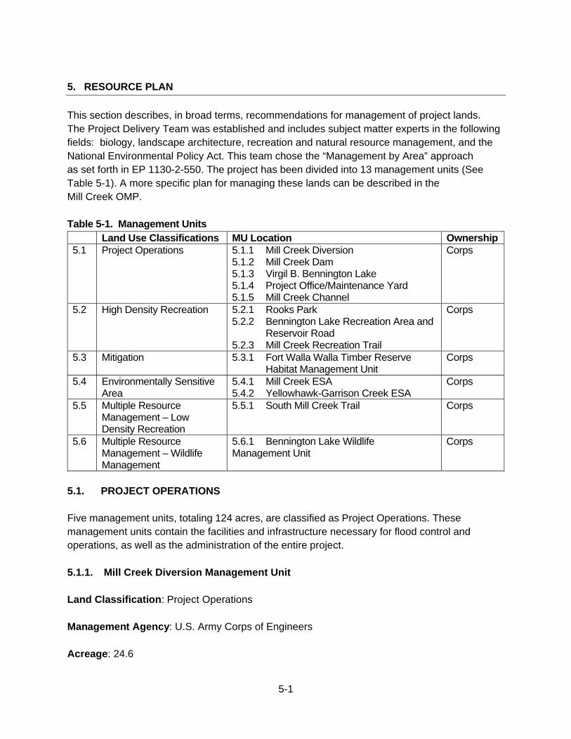
5-1
5. RESOURCE PLAN
This section describes, in broad terms, recommendations for management of project lands. The Project Delivery Team was established and includes subject matter experts in the following fields: biology, landscape architecture, recreation and natural resource management, and the National Environmental Policy Act. This team chose the “Management by Area” approach as set forth in EP 1130-2-550. The project has been divided into 13 management units (See Table 5-1). A more specific plan for managing these lands can be described in the Mill Creek OMP. Table 5-1. Management Units Land Use Classifications MU Location Ownership 5.1 Project Operations 5.1.1 Mill Creek Diversion
5.1.2 Mill Creek Dam 5.1.3 Virgil B. Bennington Lake 5.1.4 Project Office/Maintenance Yard 5.1.5 Mill Creek Channel
Corps
5.2 High Density Recreation 5.2.1 Rooks Park 5.2.2 Bennington Lake Recreation Area and Reservoir Road 5.2.3 Mill Creek Recreation Trail
Corps
5.3 Mitigation 5.3.1 Fort Walla Walla Timber Reserve Habitat Management Unit
Corps
5.4 Environmentally Sensitive Area
5.4.1 Mill Creek ESA 5.4.2 Yellowhawk-Garrison Creek ESA
Corps
5.5 Multiple Resource Management – Low Density Recreation
5.5.1 South Mill Creek Trail Corps
5.6 Multiple Resource Management – Wildlife Management
5.6.1 Bennington Lake Wildlife Management Unit
Corps
5.1. PROJECT OPERATIONS Five management units, totaling 124 acres, are classified as Project Operations. These management units contain the facilities and infrastructure necessary for flood control and operations, as well as the administration of the entire project. 5.1.1. Mill Creek Diversion Management Unit Land Classification: Project Operations Management Agency: U.S. Army Corps of Engineers Acreage: 24.6
5-2
Description and Use: The diversion was designed to help protect the city of Walla Walla from flood, as originally authorized by public law. The Diversion Dam consists of the dam, debris facilities, diversion levee, first debris barrier, second debris barrier, and fish ladder. The area behind the Diversion Dam fills with gravels and sediments and is cleared periodically to ensure proper operations of flood control facilities. Anadromous fishery resources are important to the local communities, tribes, and the region. Safe and efficient passage of anadromous fish species is an important component of the Mill Creek Diversion and highly valued by the region. Development Potential:
Improve interpretive materials to help educate the public about the projects purpose. Fish passage improvements for anadromous species as funding becomes available
in the future. Special Considerations: The area behind the dam is considered a wetland and, as such, requires special environmental considerations. 5.1.2. Mill Creek Dam Management Unit Land Classification: Project Operations Management Agency: U.S. Army Corps of Engineers Acreage: 31 Description and Use: Mill Creek Dam is a key structure in providing flood risk management to the Walla Walla Valley. This management unit contains the dam, operations house, piezometers, a discharge pipe, and Russell Creek Return canal. Russell Creek Canal is only used during flood control operations when the Mill Creek Return Canal is insufficient. Visitors frequently travel across the top of the dam to access other trails within the project’s boundaries. 5.1.3. Virgil B. Bennington Lake Management Unit Land Classification: Project Operations Management Agency: U.S. Army Corps of Engineers Acreage: 50.7 Description and Use: The project was authorized for flood control in the 1940's. In the early 1950's, however, both Federal and State agencies quickly realized the opportunity to provide the public with enhanced opportunities by filling the lake for recreation. The Walla Walla area is limited in water-oriented recreational opportunities close to the urban population. Virgil B. Bennington Lake provides one of the only popular fishing lakes for many people in the surrounding area. To maintain gamefish populations and meet public demand, the WDFW

5-3
manages the lake by stocking it with rainbow trout. Resident and migratory wildlife species are dependent on the lake for water. Vegetative corridors connecting outlying areas to the lake shoreline provide protected travel corridors. Additional Information: The water quality in Virgil B. Bennington Lake varies throughout the season. Variances in water quality are highly influenced by stagnation, increased summer temperatures, and low pool elevations. Development Potential:
Continue to manage a put and take fishery. Plant native riparian vegetation along lake shoreline to improve fish and wildlife
habitat 5.1.4. Project Office and Maintenance Yard Management Unit Land Classification: Project Operations Management Agency: U.S. Army Corps of Engineers Acreage: 4.3 Description and Use: Completed in 2013, the new Mill Creek Project Office and Visitor Center was constructed on the east side of Yellowhawk Creek. The project office and visitor center meet current regulations and guidelines. The new facilities replace the original project office located on the west side of Yellowhawk Creek. Development Potential: Continue to provide visitor information, interpretive opportunities, and materials to help inform public about the project’s purpose and various components. 5.1.5. Mill Creek Channel Management Unit Land Classification: Project Operations Management Agency: U.S. Army Corps of Engineers Acreage: 13.2 Description and Use: The Mill Creek Channel was constructed to reduce flood risk for the city of Walla Walla and surrounding areas. The Federally-owned and operated section includes about 1.5 miles of stream channel and associated levees. The channel and levees are operated and maintained in accordance with Corps regulations. Four water diversions exist within this section: 1) to divert water to Bennington Lake; 2) to supply water to Rooks Park Pond; 3) divert water to Garrison and Yellowhawk creeks, and 3) to supply water to a private landowner. The Mill Creek Channel has been highly altered and includes two dams, armored
5-4
levees, division works, and two fish ladders. The channel and attached levees include 84 full span concrete weirs. Near the downstream end of the project Mill Creek Division Works diverts a portion of its flows into Yellowhawk and Garrison Creeks. The riparian adjacent to this management unit is valuable to wildlife on the project. Wading birds, songbirds, migratory waterfowl, amphibians, and mink are commonly found in the area. Steelhead, rainbow trout, bull trout, sculpins, some forage fish species, and benthic invertebrates are also present. During the summer months visitors can be found wading/swimming in the channel, thought this activity is neither promoted nor encouraged. Fishing is not allowed in this section of Mill Creek. Development Potential: Fish passage improvements for anadromous species as funding becomes available. Special Considerations: Due to constraints of irrigation and municipal water withdrawals leading to elevated temperatures and poor water quality below the city of Walla Walla, anadromous fish may utilize the more stable perennial flows of Yellowhawk Creek. This response intensifies the importance of maintaining adequate flows in this creek for anadromous fish population viability. 5.2. HIGH DENSITY RECREATION Four management units, totaling 68.4 acres, are classified Recreation. The recreation facilities at the project help meet the regional and local demands for recreation. Maintenance and expansion of recreation facilities at the project will help meet projected increases in recreation demand. 5.2.1. Rooks Park Management Unit
Land Classification: Recreation Management Agency: U.S. Army Corps of Engineers Acreage: 18.4 Description and Use: Rooks Park is one of the most popular picnicking facilities in the Walla Walla Valley and is located in close proximity to the city of Walla Walla. It is the only park outside the city limits of Walla Walla or College Place within 28 miles. Rural location, large lawn areas, mature trees, natural vegetation, and Mill Creek create a desirable resource for visitors. Picnic tables, covered shelters, playground, restrooms, auto parking, fire rings and grills are all available to the public free of charge.
5-5
Development Potential: Provide interpretive information about the project's operations, ecology, and cultural
features. Monitor, maintain, and replace trees to maintain parks appearance and feel. Many
of the Cottonwood trees in Rooks Park are nearing the end of their lifecycle and should be removed if they are identified and hazardous to people or property.
Provide additional picnic shelters when warranted. Improve ADA access. Splash pad.
5.2.2. Bennington Lake Recreation Area and Reservoir Road Management Unit Land Classification: Recreation Management Agency: U.S. Army Corps of Engineers Acreage: 36.5 Description and Use: Bennington Lake is the only public lake within 28 miles of the city of Walla Walla. Recreation facilities include: restroom, boat launching ramp (to elevation 1,188), parking lot, irrigated lawn, picnic shelters, and BBQ grills. Fishing, picnicking, boating, cycling, and sightseeing are common activities. This management unit provides the only lake-oriented recreation for the city of Walla Walla and its environs. Reservoir Road is necessary for access to the lake and surrounding lands. It was originally constructed for project operations. The road is used heavily for recreation by both automobiles and bicyclists. The use of bicycles at the project and along the access road has increased dramatically in recent years since the project's connection to the Mill Creek Recreation Trail. Development Potential:
Provide ADA universal access trail to the lake. Provide interpretive information about the operation of the project and its
ecological features as well as signage and wayfinding to improve the user experience.
Continue to provide and enhance day-use recreation at Bennington Lake. Road Improvements (Paving).
5.2.3. Mill Creek Recreation Trail Management Unit Land Classification: Recreation Management Agency: U.S. Army Corps of Engineers Acreage: 8
5-6
Description and Use: Mill Creek Trail is connected to the city and county of Walla Walla's trail system. The trail is an important recreation resource in the Walla Walla Valley and is heavily used by visitors year round for cycling, walking, picnicking, and sightseeing. Development Potential:
Interpretive information facilities, signage, and wayfinding. Outdoor classroom/learning environment in conjunction with WWCC. Improve picnicking facilities including shade shelters and benches.
5.3. MITIGATION The Fort Walla Walla Timber Reserve (FWWTR) Management Unit (61.8 acres) was purchased in the late 1970’s to help compensate for wildlife habitat losses due to construction of the four lower Snake River dams. Land Classification: Mitigation Management Agency: U.S. Army Corps of Engineers Acreage: 62 Description and Use: This management unit was purchased under the LSRFWCP to mitigate for habitat losses due to the construction of the four lower Snake River dams. Various habitat improvements have been completed in this unit including wildlife watering sites, tree and shrub planting, dryland food plots, and establishment of perennial grasses. Whitetail deer, mule deer, songbirds, pheasants, waterfowl, and California quail are found within this unit. Hiking and limited hunting are common activities in this area. Development Potential:
Continue to establish perennial grass cover. Develop tree and shrub area plantings as recommended in the MCP Vegetation
Planting Strategy Maintain food plots. Improve signage to increase public awareness of activities that take place within this
unit (hunting in specified areas). 5.4. ENVIRONMENTALLY SENSITIVE AREAS (ESA) Two management areas are classified as Environmentally Sensitive Areas (ESA). These areas are important to the operation of the project and have been identified as having significant scientific, ecological, cultural, or aesthetic features. Development is discouraged in these areas and should be minimal.
5-7
5.4.1. Mill Creek ESA Management Unit Land Classification: Environmentally Sensitive Area Management Agency: U.S. Army Corps of Engineers Acreage: 30.9 Description and Use: The components of the wetland, open water, and steep cliff habitat, in association with the increased complexity of vegetation, provide the greatest diversity in fish and wildlife species of any habitat available in over a 40-mile radius. Due to the ESA classification development is limited. Low density recreational activities include wildlife viewing, sightseeing and hunting. Vegetation within this area consists of ponderosa pine, black cottonwood, rocky mountain maple, water birch, red-osier dogwood, Douglas hawthorn, saskatoon service berry, bittercherry, common chokecherry, golden currant, and Woods’ rose. Wildlife species include; Golden and bald eagles, mule deer, coyote, songbirds, and chukar. Fish species include: anadromous steelhead, resident rainbow trout, sculpin, forage fish, and possibly bull trout. These wetlands provide biodiversity for fish and wildlife, as well as aesthetic values. Development Potential:
Provide interpretive information about the management unit's role in the operation of the project and the area's ecology and significant species.
Perform additional restoration work to improve fish and wildlife habitat. Special Considerations:
Wetlands are protected under section 404 of the clean water act. Any disturbance must be approved through permit or consultation with partnering agencies.
5.4.2. Yellowhawk-Garrison ESA Management Unit Land Classification: Environmentally Sensitive Area Management Agency: U.S. Army Corps of Engineers Acreage: 1.7 Description and Use: Yellowhawk Creek can be operated seasonally to support migrating steelhead when there is not sufficient water in Mill Creek below the Division Point (where flows are diverted for irrigation) and when water quality conditions on Mill Creek below the city of Walla Walla have become unacceptable for fish health and migrational cues. Vegetation includes: Rocky Mountain maple, water birch, red-osier dogwood, Douglas hawthorn, Saskatoon service berry, bittercherry, common chokecherry, golden currant, and Woods’ rose. Pheasant, quail, and songbirds, anadromous steelhead, resident rainbow trout, sculpin, and forage fish are all found within the ESA.
5-8
Development Potential: Provide interpretive information about the management unit's role in the operation of
the project and the area's ecology and significant species. Perform additional restoration work to improve fish and wildlife habitat.
5.5. Multiple Resource Management, Low Density Recreation The South Mill Creek Trail Management Unit is the only Recreation, Low Density MRM on the Project. In this area, the focus is on low impact recreation activities and wildlife. Land Classification: Multiple Resource Management -- Recreation, Low Density Management Agency: U.S. Army Corps of Engineers Acreage: 24.8 Description and Use: This management unit provides gravel trail access to the Bennington Lake Habitat Management Unit. It is adjacent to levees, which will be maintained according to Corps Policy. The South Mill Creek Trail is excellent for equestrian activities, which are popular throughout the Walla Walla Valley. Sightseeing, birdwatching, and hiking are other popular activities. This management unit provides wildlife habitat and access to project operations. Riparian areas provide important wildlife habitat for local species, including deer, songbirds, and upland gamebirds. This unit provides access to wildlife observation and hunting on the adjacent habitat management units. Development Potential: Connect Mill Creek Recreation trail to Bennington Lake Trail. General recreation improvements. 5.6. MULTIPLE RESOURCE MANAGEMENT, WILDLIFE MANAGEMENT The Bennington Lake Wildlife Management Unit totals 306.0 acres and comprises approximately half of the project lands. This area is managed for multiple resources, especially wildlife habitat. It also provides for low density recreation and operations. Land Classification: Multiple Resource Management – Wildlife Management General Management Agency: U.S. Army Corps of Engineers Acreage: 308.8
5-9
Description and Use: The management unit is necessary for temporarily holding floodwaters to protect the city of Walla Walla and its environs during flood events. The management unit also provides important habitat for local wildlife populations (Whitetail deer, mule deer, songbirds, pheasants, water fowl, and California quail), and is an important area for recreational activities including hunting, bird watching, equestrian, hiking, mountain biking, fishing, and sightseeing. The project contains the only public lands large enough in acreage to support this type of low density recreation. The adjacent riparian shoreline vegetation and tree and shrub plantings provide excellent habitat diversity to the management unit. The area around Virgil B. Bennington Lake also provides resting and wintering habitat for migratory birds. Development Potential:
Improve and manage wildlife habitat and low density recreation. Implement planting strategy to improve 1950s WDFW plantings. Improve signage, and wayfinding to improve public safety and enhance the user
experience. 5.7. RESOURCE PLAN RECOMMENDATIONS The MCMP provides conceptual guidelines for the effective management of the Project. Guidelines were developed in accordance with the Corps’ master planning process. Recommendations seek to improve operations and maintenance for increased efficiency. Efficient recreation opportunities help to ensure the continued success of public access. 5.7.1 Recreation Recommendations
Regular surveys, counts and other methods to collect data and monitor trends in order to determine user capacity and environmental sustainability.
Continue to work with the Washington Department of Fish and Game to manage a put and take fishery within Bennington Lake.
Explore where feasible, more shore-based fishing opportunities (e.g., fishing platforms), and options to improve pedestrian access at Bennington Lake.
The public have expressed interest in having a designated swim area at Bennington Lake. Swimming area options should be pursued when enough public demand and funding is available. Any future designated swim areas or other swimming opportunities must meet current Corps regulations and comply with NEPA.
Current hiking trails will be maintained as presently configured. Hiking trails are an acceptable recreation feature on all land except those specifically restricted to public access. Informal trails should be discouraged and restored to pre-trail condition.
Bicycling is allowed on all trails at Mill Creek. The Corps encourages partnerships with user groups for development and maintenance of trails. Future trails will be evaluated for environmental impacts and compliance.
Trails remain open to equestrian use. To accommodate more regular equestrian use, some facilities (i.e., hitching posts) have been proposed by equestrian groups. As with other uses, the Corps will look for opportunities to partner with these groups to
5-10
assist with the development and maintenance of these facilities. Equestrian trails may be located on all Corps land except where restricted to public access. Future trails will be evaluated for environmental impacts and compliance.
Existing trails at Mill Creek are currently shared by those on horseback, foot, or bicycle. Trails remain open for shared use as long as users do not have serious conflict. In the event of ongoing user conflicts, Project staff may need to assign users to specific areas. Commonly accepted trail etiquette maintains that bicyclists yield to hikers and those on horses. Hikers yield to horses. The rationale behind this is that bicyclists and hikers may respond more quickly and rationally to movement or surprises than a horse or person on horseback.
5.7.2 Natural Resource Recommendations
Continue to follow guidance provided in Mill Creek Biological Assessments and Biological Opinions for ESA-listed species.
Invasive plant species can significantly degrade wildlife habitat, increase soil erosion, and outcompete native species that fish and wildlife depend upon and are culturally significant to Tribes. Species should be inventoried and surveyed to determine prioritization of control.
Inventory and monitor informal trails. Trails should be discouraged and removed when impacts to natural resources and sensitive areas are occurring.
Continue to enhance riparian and upland biodiversity through restoration projects that focus on planting native trees, shrubs, and groundcovers. Focus on areas identified in the Mill Creek Planting Strategy.
5.7.3 Education, Information, and Public Safety Recommendations
Signage and wayfinding improvements should be made along trails to improve user experience. During the scoping process, members of the public expressed interest in the development of signage along trails. As funding and manpower is available, efforts could be made to improve signage and wayfinding on existing trails to improve the users experience, notify users of approved uses of project lands, and provide interpretative opportunities regarding the uniqueness of the area, vegetation, wildlife, and other natural features.
Public safety concerns around hunting activities on project lands were expressed during the scoping process. In order to address public concerns regarding hunting activities at Mill Creek, staff may participate with local hunting groups to discuss issues and concerns, increase patrols and outreach with hunters and non-hunters, and add temporary signs at trailheads and along trails during hunting season notifying of hunting zones, and rules. More info about this is available in Section 6.1.
Encourage zero tolerance of litter through education and volunteer groups as well as providing pack-it-in, pack-it-out bags at various trailheads.
5-11
Utilize current digital technologies so users can access digital information that is pertinent to the project (e.g. trail closures, hunting season, current conditions, stocking reports, etc.).
Seek opportunities to partner with regional Tribes and other groups to provide and educational and interpretive signs, activities, and programming
5.7.4 Future Demands Recommendations in this Plan reflect current inventory data, recreation trends, and forecasts. As technology and public demand change and new recreational opportunities arise, Corps staff will investigate the feasibility of new activities and evaluate proposed changes and additions to this Plan for potential conflicts, opportunities, and environmental impacts.
6-1
6. SPECIAL TOPICS, ISSUES, AND/OR CONSIDERATIONS
6.1. GENERAL This section discusses the special topics, issues, and considerations the Project Delivery Team identified as important to the future management of the Mill Creek Project. Special topics, issues, and considerations are defined in this context as any problems, concerns, and/or needs that could affect or are affecting the stewardship and management potential of the lands and waters under the jurisdiction of the Walla Walla District, Mill Creek Project. 6.1.1 Hunting Currently hunting is allowed in designated areas between September 1 and January 31. All hunters must follow current state regulations established by WDFW. Archery and shotgun are the only approved methods for hunting on project lands. No hunting is allowed adjacent to Bennington Lake to provide a safety buffer to prohibit conflicts with other users (See Plate 6-1). The hunting season at Mill Creek was reduced in 2007 from year round hunting to a five month season during lower visitation months, which allows the hunting opportunities to meet mitigation needs and user requests. During the public scoping process in 2015, members of the public expressed concerns about hunting and their safety on project lands. In response to the public’s comments the Corps queried several state and Federal agencies about addressing hunting related concerns. Through these discussions several actions have been proposed to improve public safety and awareness of hunting activities at Mill Creek
Corps actively participate in meetings with local hunting groups to discuss issues, concerns, coordinate site visits, and discuss hunting opportunities.
Utilize media to increase awareness of hunting opportunities and seasons. “No hunting” signage will be maintained to inform recreational users of the hunting
boundary. Staff will also install temporary signs along trails and trailheads during hunting season (September 1 through January 31).
Increase patrols and outreach with hunters and non-hunters educating visitors about the hunting zones, seasons, and rules.
Assess hunting boundaries annually, including the Meadowlark trail, evaluating safety issues such as visibility, consistency, and geographic constraints.
Continue to seek feedback on user concerns at the Mill Creek Project by use of mail, email ([email protected]), social media, and comment cards.
Due to the increasing use of the project with its constrained footprint, hunting practices will be re-examined periodically to see if changes to policy are needed.
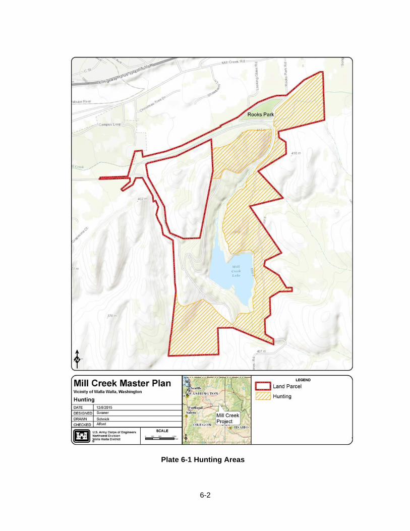
6-2
Plate 6-1 Hunting Areas
6-3
6.1.2 Visitor Increase Since the completion of the 1993 Master Plan yearly visits have increased from 269,600 visits in 1993 to 302,004 visits in 2012, a 12% increase. The project has been able to absorb this increase in visitor use without major impacts to natural resources. The existing recreation facilities at the project help to meet the recreation needs of the Walla Walla Valley but as populations in the area steadily grow and popularity of the project increases there is potential for overcrowding and resource degradation. Social carrying capacity has already exceeded acceptable levels on and around the shoreline of Bennington Lake during spring and summer months. Any feasible options to improve water based recreation experience at Bennington Lake should be explored when funding and resources are available. Constrained by project size (acreage) there are limited opportunities for future development at the Mill Creek Project. Access to outdoor recreation within close proximity to Walla Walla is in high demand and the project will continue to explore methods to meet both current and future recreational needs. All future developments should be carefully considered and analyzed to assess the full range of impacts to natural resources and fish and wildlife associated with any new development. If user conflicts, disturbance to fish and wildlife, and degradation of project natural resources are persistent and ongoing, USACE staff will re-assess current uses of project lands and water and make necessary changes to ensure that resources are protected. Focus should be placed on maintaining and improving existing facilities, trails, fish and wildlife habitat, and other features specific to Mill Creek in order to make this resource available to future generations.
7-1
7. AGENCY AND PUBLIC COORDINATION
Public involvement and extensive coordination within the Corps and other affected agencies and organizations is a critical requirement in development or revision of a Project Master Plan.
7.1 SCOPING A public scoping process for the revised MCMP was initiated in March 2015. More than 50 letters were sent to interested public, organizations, stakeholders, Federal and state congressional offices, and agencies offering the opportunity to comment on the scoping process for the master plan update. The Corps conducted a public scoping meeting in Walla Walla, Washington, March 31, 2015, to support an update to the master plan. Scoping meetings are a useful tool to obtain information from the public and other governmental agencies. For a planning process like this, the scoping process was also used as an opportunity to get input from the public and agencies about the vision for the MP update and the issues that the MP should address where possible. There were approximately 80 people in attendance at the meeting. During the scoping period the Corps received suggestions and comments related to management issues and recreation at the Project. The majority of comments focused on:
Public safety concerns related to hunting. Improved signage and trail markers. Control of invasive plant species.
The general concept presented was to protect the natural aspects of the lake and surrounding area to enhance the fish and wildlife habitat. Comments compiled from attendees at the public scoping meeting and other sources were used to update the Plan. Refer to Appendix B for scoping comments. 7.2 TRIBAL COORDINATION The Corps places priority on building good relationships with regional Tribes. As part of the master planning process, The Corps sent letters to the Nez Perce Tribe and the Confederated Tribes of the Umatilla Indian Reservation (CTUIR) on April 16, 2015, and offered Government to Government consultation. Also, the Corps and CTUIR technical staffs met and discussed the proposed MCMP update. Although this was not formal consultation between the Corps and the CTUIR, Corps staff conveyed background and information regarding the master planning process and proposed content. Coordination on the MCMP update with the Tribes continued throughout the process. In, September 2015, the Corps sent letters to the CTUIR and the Nez Perce Tribe requesting review and comment on the Draft Proposed MCMP, Draft Finding of No Significant Impact (FONSI) and EA.
7-2
7.3 AGENCY INVOLVEMENT AND COORDINATION All development will be coordinated with appropriate Federal, state, and local agencies throughout the planning process.
7.4 THE CORPS WEBSITE
The Corps developed a webpage (http://www.nww.usace.army.mil/Missions/Projects/ MillCreekMP.aspx) to provide information, updates, and collect comments for the MCMP update. Draft and final Plan with associated documents will be placed on this webpage for the public to view. 7.5 THE DRAFT MCMP/EA The Draft MCMP, Draft FONSI and EA were released to the public in September 2015 for a 30 day review period. Comments received from review of the Draft MCMP, Draft FONSI and EA have been summarized, with comment responses found in Appendix B of the MCMP, and in the final FONSI. The MCMP/EA was finalized in January 2016 and submitted for approval.
8-1
8. SUMMARY OF RECOMMENDATIONS
8.1. GENERAL This revised MCMP presents an inventory of land resources and how they are classified, existing park facilities, analysis of resource use, anticipated influences of project operation and management, and an evaluation of existing and future needs. The MCMP is a living document establishing the basic direction for management and development of the Project in agreement with the capabilities of the resource and public needs. The plan is flexible in that supplementation can be achieved through a formal process that addresses unforeseen needs. The master plan will be periodically reviewed to facilitate the evaluation and utilization of new information as it becomes available. The MCMP will guide the use, development, and management of the Project in a manner that optimizes public benefits within resource potentials and the authorized function of the project while remaining consistent with Corps policies, regulations, and environmental operating principals. 8.2. RECOMMENDATIONS Below are recommendations to manage Mill Creek Projects current and future issues. 8.2.1 Recreation Recommendations
As recreation use increases, periodic surveys, counts or other methods to collect
data and monitor trends should be conducted in order to determine user capacity and environmental sustainability of current uses.
Explore where feasible, more shore-based fishing opportunities and options to improve pedestrian access to the lake.
Swimming areas options should be pursued when enough public demand and funding is available. Any future designated swim areas or other swimming opportunities must meet current Corps regulations and comply with NEPA
8.2.2 Natural Resource Recommendations
Invasive plant species can significantly degrade wildlife habitat, increase soil erosion,
and outcompete native species that fish and wildlife depend upon and are culturally significant to Tribes. Species should be inventoried and surveyed to determine prioritization of control.
Inventory and monitor informal trails. Trails should be discouraged and removed when impacts to natural resources and sensitive areas are occurring.
8-2
Continue to enhance riparian and upland biodiversity through restoration projects that focus on planting native trees, shrubs, and groundcovers. Focus on areas identified in the Mill Creek Planting Strategy.
8.2.3 Education, Information, and Public Safety Recommendations
As funding and manpower is available, signage and wayfinding improvements should
be made along trails to improve user experience, notify users of approved uses of project lands, and provide interpretative opportunities regarding the uniqueness of the area, vegetation, wildlife, and other natural features.
In order to address public concerns regarding hunting activities at Mill Creek, staff may participate with local hunting groups to discuss issues and concerns, increase patrols and outreach with hunters and non-hunters, and add temporary signs at trailheads and along trails during hunting season notifying of hunting zones, and rules. More info about this is available in Section 6.1.
Encourage zero tolerance of litter through education and volunteer groups as well as providing pack-it-in, pack-it-out bags at various trailheads.
Utilize current digital technologies so users can access digital information that is pertinent to the project (e.g. trail closures, hunting season, current conditions, stocking reports, etc.).
Seek opportunities to partner with regional Tribes and other groups to provide and educational and interpretive activities, and programming
8.2.4 Proposed Management Unit Changes As described in Section 4.4, the interdisciplinary team identified several changes to existing management units to better reflect current project operations. See Table 4-7 for recommended management unit changes.
9-1
9. BIBLIOGRAPHY
Ames, Kenneth M., Don E. Dumond, Jerry F. Galm, and Rick Minor. 1998 Prehistory of the Southern Plateau. In Plateau, edited by Deward E. Walker Jr., pp. 103-119. Handbook of North American Indians, volume 12, W.C. Sturtevant, general editor. Smithsonian Institution, Washington, D.C. Anglin, D.R., M. Barrows, R. Koch, J. Skalicky, and C. Newlon. 2012. Use of the mainstem
Columbia River by Walla Walla Basin bull trout. Draft report to the US Army Corps of Engineers, Walla Walla District prepared by US Fish and Wildlife Service, Columbia River Fisheries Program Office, Walla Walla: US Army Corps of Engineers.
Beckham, Stephen Dow 1998 History Since 1846. In Plateau, edited by Deward E. Walker Jr., pp. 149-173. Handbook of North American Indians, volume 12, W.C. Sturtevant, general editor. Smithsonian Institution, Washington, D.C. Bowker, J.M.; Askew, A.; Cordell, H.; Betz, C.; Zarnoch, S.; Seymour, L. 2012. Outdoor Recreation participation in the United States – Projections to 2060: a technical document supporting the Forest Service 2010 RPA Assessment. U.S. Department of Agriculture Forest Service. Daubenmire, R. 1970. Steppe Vegetation of Washington. Washington Agricultural Experiment Station, Technical Bulletin 62, College of Agriculture, Washington State University, Pullman, Washington.
Environmental Protection Agency. 2011. Terrestrial Ecoregions Level 3. ftp://ftp.epa.gov/wed/ecoregions/pubs/NA_TerrestrialEcoregionsLevel3_Final- 2june11_CEC.pdf pg 46-46 Leonhardy, Frank C. and David Rice. 1970. A Proposed Cultural Typology for the Lower Snake River Region, Southeastern Washington. Northwest Anthropological Research Notes 4:1-29. Lindsley, Sara 2011 Fort Walla Walla Museum: 2011 Teacher’s Guide. Fort Walla Walla Museum/Walla Walla Valley Historical Society. Walla Walla, Washington. Lyman, W.D. 1901. An Illustrated Historic of Walla Walla County, State of Washington. W.H. Lever Publisher. McCroskey, Lauren. 2009. Evaluation of National Register Eligibility Mill Creek Flood Control
Project Walla Walla, Washington. Center for Expertise for the Preservation of Historic Buildings and Structures. Prepared for: Environmental Compliance, U.S. Army Corps of Engineers, Walla Walla District, 201 North 3rd Avenue, Walla Walla, WA 99362-1876. Report on file.
9-2
Stern, Theodore 1998. Cayuse, Umatilla, and Walla Walla. In Plateau, edited by Deward E. Walker Jr., pp. 395-419. Handbook of North American Indians, volume 12, W.C. Sturtevant, general editor. Smithsonian Institution, Washington, D.C. Stinson, D.W. 2001. Washington state recovery plan for the lynx. Washington Department of
Fish and Wildlife, Olympia, Washington. 78 pp + 5 maps. Walker, Deward E., and Roderick Sprague 1998 History Until 1846. In Plateau, edited by Deward E. Walker Jr. pp. 395-419. Handbook of North American Indians, volume 12, W.C. Sturtevant, general editor. Smithsonian Institution, Washington, D.C. U.S Army Corps of Engineers (Corps). 1986. Mill Creek Channel Rehabilitation - Placement
of Stones for Fish Habitat, Contract 86-C-30. US Army Corps of Engineers (Corps). 1993. Mill Creek Master Plan US Army Corps of Engineers (Corps). 2015. Mill Creek Operations and Maintenance Biological
Assessment and Biological Evaluation. Environmental Compliance Section, Walla Walla District.
US Fish and Wildlife Service. 1984. Planning Aid Report for the Mill Creek (Walla Walla, Washington) Study, prepared for the U.S. Army Corps of Engineers, Walla Walla District, Walla Walla, Washington, Olympia, Washington. Washington State Recreation and Conservation Office. 2013. Outdoor Recreation in Washington, The 2013 State Comprehensive Outdoor Recreation Plan. http://www.rco.wa.gov/documents/rec_trends/2013-2018SCORP-FullRpt.pdf
A-1
APPENDIX A PERTINENT DATA SHEET
Official Name: Mill Creek, Washington U.S. Army Corps of Engineers Reference: Mill Creek Project Location: State - Washington County - Walla Walla Stream - Mill Creek Construction Completion Dates: Dam and appurtenant works - 1942 Mill Creek Channel - 1949 Owner: U.S. Government Managers: U.S. Army Corps of Engineers and Mill Creek Flood Control Zone District Authorized purposes: Flood control and recreation Type of Project: Channelization and off-stream storage **Real Estate: 611.46 acres of owned lands and 87.27 acres of easement lands Federally-Owned Units Diversion Works Diversion Dam: Spillway Type - Ambursen, ogee crest Length at crest - 250 ft Crest elevation – 1,261 Height - 14 ft Design discharge, cs (with water surface elevation 1268) - 17,000 Concrete structure top elevation - 1270 Stilling basin length - 24 ft Stilling basin invert elevation - 1245 Type - Radial sluice gate Size - 6x8 ft Number - 1 Sill elevation - 1247 Control – Electric motor with manual backup Spillway/Channel capacity – 3,500 cfs. Low flow gate maximum discharge - 400 cfs
A-2
Fish Ladder: Width - 6.5 ft Capacity - 42 cfs Operating range elevation – 1,253 to 1,256 Intake invert elevation – 1,250.25 Exit invert elevation – 1,245 Stilling Basin: Length - 4 ft Width - 19.5 ft Floor elevation - 1242
Diversion Levee: Type - Earthfill with heavy gravel face Crest elevation – 1,270 to 1,280 ft Length at crest - 2,200 ft Top width - 12 ft Maximum height - 23 ft Design freeboard (standard project flood) - 5 ft
End sill elevation - 1244 Debris Facilities
Debris Barriers: Location - Diversion Dam forebay Length - 550 ft Type - Steel crib and cable
Shear Wall: Location - Headworks Intake Canal Length - 90 ft Type - Panel
Intake Canal Facilities Headworks: Type - Concrete non-overflow with radial gates Gate size – 8x18 ft Number - 4 Sill elevation – 12,525 Control - Manual (optional use of portable electric operator) Canal: Intake canal end, elevation - 1,250 Invert elevation - 1,252 Capacity - 7,000 cfs Intake canal base width - 80 ft Intake canal length - 1,800 ft Off-Stream Storage Reservoir (Virgil B. Bennington Lake) Name: Virgil B. Bennington Lake*** Maximum pool elevation for flood control - 1,265 Capacity at elevation 1,265 – 8,300 acre-feet Maximum allowable time for storage above elevation 1,235 (due to stoppage) - 15 days Capacity at elevation 1,235 – 3,300 acre-ft
A-3
Storage Dam (Mill Creek Dam)
Type: Earthfill with heavy gravel face Crest elevation - 1,270 Length at crest - 3,200 ft Top width - 20 ft Height above valley floor - 1,150 ft Toe of embankment, elevation - 1,215
Maximum width at base - 800 Embankment Toe drains: Date nine wells rehabilitated, year - 1979 Drainage discharge header, elevation - 1,135 CP manhole diameter - 48 in
Outlet Works
Intake Tower: Slide gate, centerline elevation – 1,179 Intake tower, weir overflow elevation – 1,212 Lower sluice gate, centerline elevation – 1,189
Beneath Dam: Type - Steel pipe Diameter - 42 in Length - 900 ft Discharge pipe, elevation (varies) – 1,147.5 to 1,181
To Mill Creek Return Canal: Valve type - butterfly valve Diameter - 42 in Length - 460 ft Invert elevation at discharge end – 1,210
To Russell Creek Canal: Pipe Diameter - 36 in Length - 125 ft Howell-Bunger valve, elevation - 1147.5
Outlet Canals
Mill Creek Return Canal: Type - Trapezoidal Slope - .0008 Lining - Shotcrete Hydraulic capacity - 190 cfs Invert elevation at discharge end-1210 ft
Russell Creek Canal: Type - Trapezoidal Slope - 0.01 Lining - Concrete Hydraulic capacity - 250 cfs Howell-Bunger valve elevation - 1147.5
Division Works First Division Works
Mill Creek: Gate type - Vertical lift gate Size of opening: Total width of openings - 97 ft Height - 6 ft Channel capacity - 3,500 cfs
To Yellowhawk-Garrison Canal: Gate type - Radial lift gate Total width of openings - 14 ft Height - 6 ft
Fish Ladder Operating Elevations:
A-4
Width - 8 Ladder design capacity - 15 cfs Slope - 0 Second Division Works
Yellowhawk Creek: Ungated - 60 Channel capacity - 60 cfs
Garrison Creek: Gate type - Slide gate Channel capacity - 10 cfs
Mill Creek Flood Control Zone District Units
Gose Street to Mullan Avenue: Type - Riprapped levee Length - 1.9 miles Capacity - 3,500 cfs
Mullan Avenue to Roosevelt Street: Type - Concrete-lined Length - 2.2 miles Capacity - 5,400 cfs
Roosevelt Street to Diversion Dam: Type - Riprapped levee Length - 2.8 miles Capacity - 3,500 cfs Hydrologic Data 5-year flood event, natural - 2,000 cfs 5-year flood event, regulated - 1,470 cfs**** 100-year flood event, natural - 7,050 cfs 100-year flood event, regulated - 3,500 cfs Standard project flood - 11,300 cfs Largest flood, 1931 - 6,000 cfs Mill Creek drainage basin above Mill Creek at Walla Walla stream gage - 96 sq miles
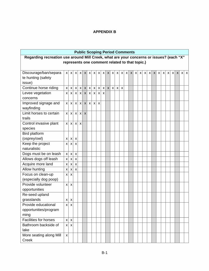
B-1
APPENDIX B
Public Scoping Period Comments Regarding recreation use around Mill Creek, what are your concerns or issues? (each “X”
represents one comment related to that topic.)
Discourage/ban/separate hunting (safety issue)
x x x x x x x x x x x x x x x x x x x x x x x x x x x
Continue horse riding x x x x x x x x x x x x x Levee vegetation concerns
x x x x x x x x x
Improved signage and wayfinding
x x x x x x x x
Limit horses to certain trails
x x x x x
Control invasive plant species
x x x x
Bird platform (osprey/owl) x x x Keep the project naturalistic
x x x
Dogs must be on leash x x x Allows dogs off leash x x x Acquire more land x x x Allow hunting x x x Focus on clean-up (especially dog poop)
x x
Provide volunteer opportunities
x x
Re-seed upland grasslands x x Provide educational opportunities/programming
x x
Facilities for horses x x Bathroom backside of lake
x x
More seating along Mill Creek
x
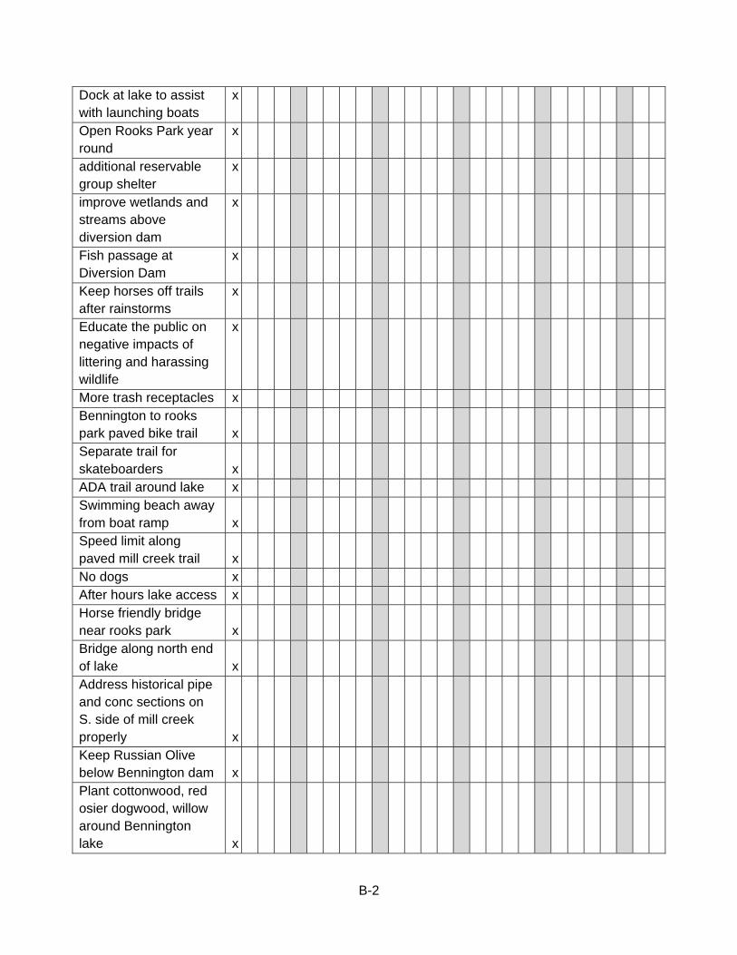
B-2
Dock at lake to assist with launching boats
x
Open Rooks Park year round
x
additional reservable group shelter
x
improve wetlands and streams above diversion dam
x
Fish passage at Diversion Dam
x
Keep horses off trails after rainstorms
x
Educate the public on negative impacts of littering and harassing wildlife
x
More trash receptacles x Bennington to rooks park paved bike trail x Separate trail for skateboarders x ADA trail around lake x Swimming beach away from boat ramp x Speed limit along paved mill creek trail x No dogs x After hours lake access x Horse friendly bridge near rooks park x Bridge along north end of lake x Address historical pipe and conc sections on S. side of mill creek properly x Keep Russian Olive below Bennington dam x Plant cottonwood, red osier dogwood, willow around Bennington lake x

B-3
Limit vehicles during fishing weekends x Reservation system for hunting x Speed bumps along Mill Creek paved path x Whitetail Trail closed and restored x Dogs on leash April-Aug x Bicycles restricted to paved surfaces x
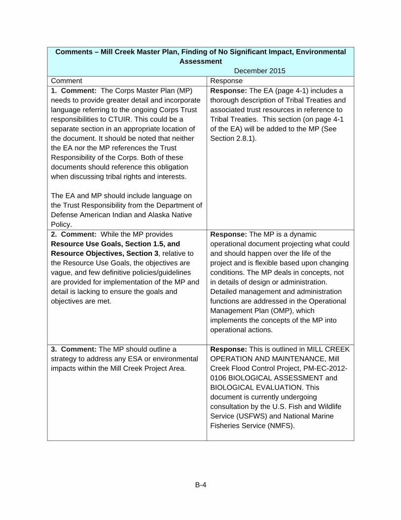
B-4
Comments – Mill Creek Master Plan, Finding of No Significant Impact, Environmental Assessment
December 2015 Comment Response 1. Comment: The Corps Master Plan (MP) needs to provide greater detail and incorporate language referring to the ongoing Corps Trust responsibilities to CTUIR. This could be a separate section in an appropriate location of the document. It should be noted that neither the EA nor the MP references the Trust Responsibility of the Corps. Both of these documents should reference this obligation when discussing tribal rights and interests. The EA and MP should include language on the Trust Responsibility from the Department of Defense American Indian and Alaska Native Policy.
Response: The EA (page 4-1) includes a thorough description of Tribal Treaties and associated trust resources in reference to Tribal Treaties. This section (on page 4-1 of the EA) will be added to the MP (See Section 2.8.1).
2. Comment: While the MP provides Resource Use Goals, Section 1.5, and Resource Objectives, Section 3, relative to the Resource Use Goals, the objectives are vague, and few definitive policies/guidelines are provided for implementation of the MP and detail is lacking to ensure the goals and objectives are met.
Response: The MP is a dynamic operational document projecting what could and should happen over the life of the project and is flexible based upon changing conditions. The MP deals in concepts, not in details of design or administration. Detailed management and administration functions are addressed in the Operational Management Plan (OMP), which implements the concepts of the MP into operational actions.
3. Comment: The MP should outline a strategy to address any ESA or environmental impacts within the Mill Creek Project Area.
Response: This is outlined in MILL CREEK OPERATION AND MAINTENANCE, Mill Creek Flood Control Project, PM-EC-2012-0106 BIOLOGICAL ASSESSMENT and BIOLOGICAL EVALUATION. This document is currently undergoing consultation by the U.S. Fish and Wildlife Service (USFWS) and National Marine Fisheries Service (NMFS).
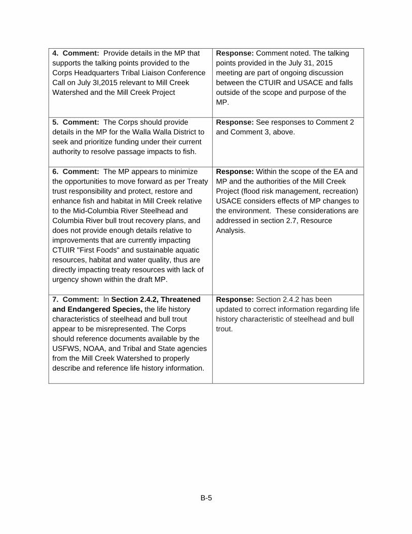
B-5
4. Comment: Provide details in the MP that supports the talking points provided to the Corps Headquarters Tribal Liaison Conference Call on July 3I,2015 relevant to Mill Creek Watershed and the Mill Creek Project
Response: Comment noted. The talking points provided in the July 31, 2015 meeting are part of ongoing discussion between the CTUIR and USACE and falls outside of the scope and purpose of the MP.
5. Comment: The Corps should provide details in the MP for the Walla Walla District to seek and prioritize funding under their current authority to resolve passage impacts to fish.
Response: See responses to Comment 2 and Comment 3, above.
6. Comment: The MP appears to minimize the opportunities to move forward as per Treaty trust responsibility and protect, restore and enhance fish and habitat in Mill Creek relative to the Mid-Columbia River Steelhead and Columbia River bull trout recovery plans, and does not provide enough details relative to improvements that are currently impacting CTUIR "First Foods" and sustainable aquatic resources, habitat and water quality, thus are directly impacting treaty resources with lack of urgency shown within the draft MP.
Response: Within the scope of the EA and MP and the authorities of the Mill Creek Project (flood risk management, recreation) USACE considers effects of MP changes to the environment. These considerations are addressed in section 2.7, Resource Analysis.
7. Comment: ln Section 2.4.2, Threatened and Endangered Species, the life history characteristics of steelhead and bull trout appear to be misrepresented. The Corps should reference documents available by the USFWS, NOAA, and Tribal and State agencies from the Mill Creek Watershed to properly describe and reference life history information.
Response: Section 2.4.2 has been updated to correct information regarding life history characteristic of steelhead and bull trout.
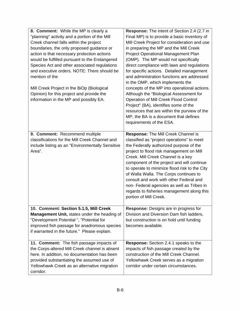
B-6
8. Comment: While the MP is clearly a "planning" activity and a portion of the Mill Creek channel falls within the project boundaries, the only proposed guidance or action is that necessary protection actions would be fulfilled pursuant to the Endangered Species Act and other associated regulations and executive orders. NOTE: There should be mention of the Mill Creek Project in the BiOp (Biological Opinion) for this project and provide the information in the MP and possibly EA.
Response: The intent of Section 2.4 (2.7 in Final MP) is to provide a basic inventory of Mill Creek Project for consideration and use in preparing the MP and the Mill Creek Project Operational Management Plan (OMP). The MP would not specifically direct compliance with laws and regulations for specific actions. Detailed management and administration functions are addressed in the OMP, which implements the concepts of the MP into operational actions. Although the “Biological Assessment for Operation of Mill Creek Flood Control Project” (BA), identifies some of the resources that are within the purview of the MP, the BA is a document that defines requirements of the ESA.
9. Comment: Recommend multiple classifications for the Mill Creek Channel and include listing as an "Environmentally Sensitive Area".
Response: The Mill Creek Channel is classified as “project operations” to meet the Federally authorized purpose of the project to flood risk management on Mill Creek. Mill Creek Channel is a key component of the project and will continue to operate to minimize flood risk to the City of Walla Walla. The Corps continues to consult and work with other Federal and non- Federal agencies as well as Tribes in regards to fisheries management along this portion of Mill Creek.
10. Comment: Section 5.1.5, Mill Creek Management Unit, states under the heading of "Development Potential ", "Potential for improved fish passage for anadromous species if warranted in the future.” Please explain.
Response: Designs are in progress for Division and Diversion Dam fish ladders, but construction is on hold until funding becomes available.
11. Comment: The fish passage impacts of the Corps-altered Mill Creek channel is absent here. In addition, no documentation has been provided substantiating the assumed use of Yellowhawk Creek as an alternative migration corridor.
Response: Section 2.4.1 speaks to the impacts of fish passage created by the construction of the Mill Creek Channel. Yellowhawk Creek serves as a migration corridor under certain circumstances.
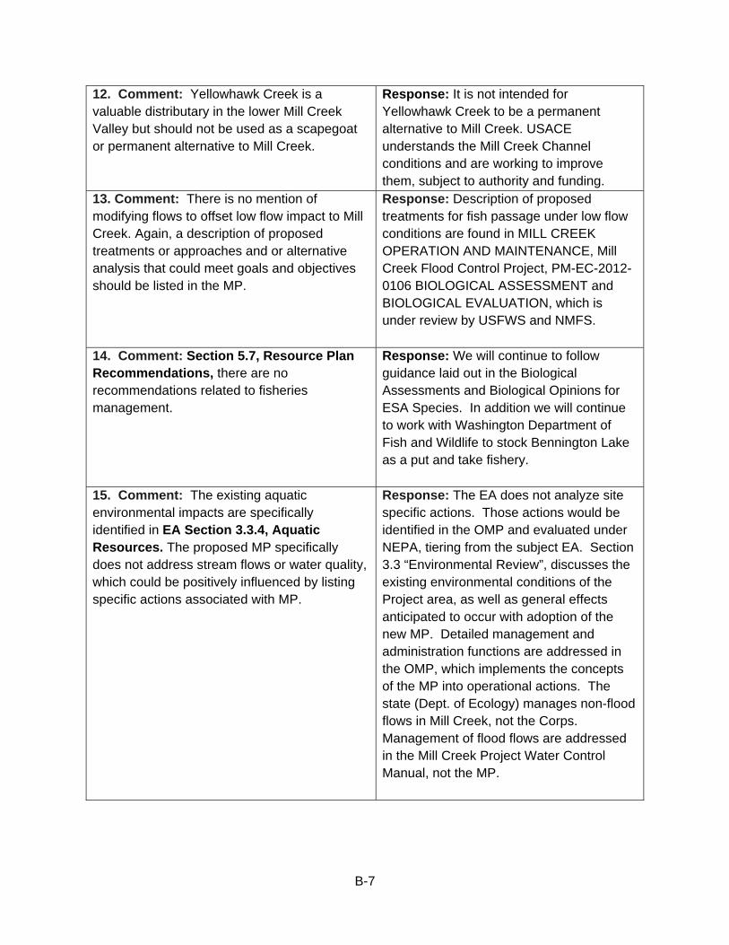
B-7
12. Comment: Yellowhawk Creek is a valuable distributary in the lower Mill Creek Valley but should not be used as a scapegoat or permanent alternative to Mill Creek.
Response: It is not intended for Yellowhawk Creek to be a permanent alternative to Mill Creek. USACE understands the Mill Creek Channel conditions and are working to improve them, subject to authority and funding.
13. Comment: There is no mention of modifying flows to offset low flow impact to Mill Creek. Again, a description of proposed treatments or approaches and or alternative analysis that could meet goals and objectives should be listed in the MP.
Response: Description of proposed treatments for fish passage under low flow conditions are found in MILL CREEK OPERATION AND MAINTENANCE, Mill Creek Flood Control Project, PM-EC-2012-0106 BIOLOGICAL ASSESSMENT and BIOLOGICAL EVALUATION, which is under review by USFWS and NMFS.
14. Comment: Section 5.7, Resource Plan Recommendations, there are no recommendations related to fisheries management.
Response: We will continue to follow guidance laid out in the Biological Assessments and Biological Opinions for ESA Species. In addition we will continue to work with Washington Department of Fish and Wildlife to stock Bennington Lake as a put and take fishery.
15. Comment: The existing aquatic environmental impacts are specifically identified in EA Section 3.3.4, Aquatic Resources. The proposed MP specifically does not address stream flows or water quality, which could be positively influenced by listing specific actions associated with MP.
Response: The EA does not analyze site specific actions. Those actions would be identified in the OMP and evaluated under NEPA, tiering from the subject EA. Section 3.3 “Environmental Review”, discusses the existing environmental conditions of the Project area, as well as general effects anticipated to occur with adoption of the new MP. Detailed management and administration functions are addressed in the OMP, which implements the concepts of the MP into operational actions. The state (Dept. of Ecology) manages non-flood flows in Mill Creek, not the Corps. Management of flood flows are addressed in the Mill Creek Project Water Control Manual, not the MP.
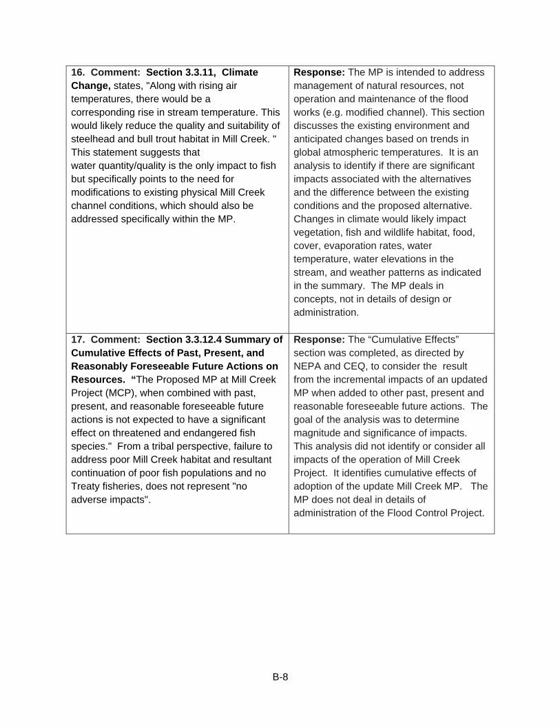
B-8
16. Comment: Section 3.3.11, Climate Change, states, "Along with rising air temperatures, there would be a corresponding rise in stream temperature. This would likely reduce the quality and suitability of steelhead and bull trout habitat in Mill Creek. " This statement suggests that water quantity/quality is the only impact to fish but specifically points to the need for modifications to existing physical Mill Creek channel conditions, which should also be addressed specifically within the MP.
Response: The MP is intended to address management of natural resources, not operation and maintenance of the flood works (e.g. modified channel). This section discusses the existing environment and anticipated changes based on trends in global atmospheric temperatures. It is an analysis to identify if there are significant impacts associated with the alternatives and the difference between the existing conditions and the proposed alternative. Changes in climate would likely impact vegetation, fish and wildlife habitat, food, cover, evaporation rates, water temperature, water elevations in the stream, and weather patterns as indicated in the summary. The MP deals in concepts, not in details of design or administration.
17. Comment: Section 3.3.12.4 Summary of Cumulative Effects of Past, Present, and Reasonably Foreseeable Future Actions on Resources. “The Proposed MP at Mill Creek Project (MCP), when combined with past, present, and reasonable foreseeable future actions is not expected to have a significant effect on threatened and endangered fish species." From a tribal perspective, failure to address poor Mill Creek habitat and resultant continuation of poor fish populations and no Treaty fisheries, does not represent "no adverse impacts".
Response: The “Cumulative Effects” section was completed, as directed by NEPA and CEQ, to consider the result from the incremental impacts of an updated MP when added to other past, present and reasonable foreseeable future actions. The goal of the analysis was to determine magnitude and significance of impacts. This analysis did not identify or consider all impacts of the operation of Mill Creek Project. It identifies cumulative effects of adoption of the update Mill Creek MP. The MP does not deal in details of administration of the Flood Control Project.
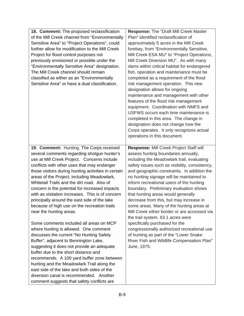
B-9
18. Comment: The proposed reclassification of the Mill Creek channel from "Environmentally Sensitive Area" to "Project Operations", could further allow for modification to the Mill Creek Project for flood control purposes not previously envisioned or possible under the "Environmentally Sensitive Area" designation. The Mill Creek channel should remain classified as either as an "Environmentally Sensitive Area" or have a dual classification.
Response: The “Draft Mill Creek Master Plan” identified reclassification of approximately 5 acres in the Mill Creek forebay, from “Environmentally Sensitive, Mill Creek ESA MU” to “Project Operations, Mill Creek Diversion MU”. As with many dams within critical habitat for endangered fish, operation and maintenance must be completed as a requirement of the flood risk management operation. This new designation allows for ongoing maintenance and management with other features of the flood risk management equipment. Coordination with NMFS and USFWS occurs each time maintenance is completed in this area. The change in designation does not change how the Corps operates. It only recognizes actual operations in this document.
19. Comment: Hunting. The Corps received several comments regarding shotgun hunter’s use at Mill Creek Project. Concerns include conflicts with other uses that may endanger those visitors during hunting activities in certain areas of the Project, including Meadowlark, Whitetail Trails and the dirt road. Also of concern is the potential for increased impacts with as visitation increases. This is of concern principally around the east side of the lake because of high use on the recreation trails near the hunting areas. Some comments included all areas on MCP where hunting is allowed. One comment discusses the current “No Hunting Safety Buffer”, adjacent to Bennington Lake, suggesting it does not provide an adequate buffer due to the short distance and recommends. A 100 yard buffer zone between hunting and the Meadowlark Trail along the east side of the lake and both sides of the diversion canal is recommended. Another comment suggests that safety conflicts are
Response: Mill Creek Project Staff will assess hunting boundaries annually, including the Meadowlark trail, evaluating safety issues such as visibility, consistency, and geographic constraints. In addition the no hunting signage will be maintained to inform recreational users of the hunting boundary. Preliminary evaluation shows that hunting areas would generally decrease from this, but may increase in some areas. Many of the hunting areas at Mill Creek either border or are accessed via the trail system. 63.1 acres were specifically purchased for the congressionally authorized recreational use of hunting as part of the “Lower Snake River Fish and Wildlife Compensation Plan” June, 1975.
B-10
greater than presented in the Draft MP and the proposed signing and public involvement will do very little to reduce conflicts. Recommendations from comments include changing hunting boundaries, limiting hunting, phasing out hunting or an immediate stop to all hunting at Mill Creek Project. 20. Comment: Equestrian. Several comments provide strong support for the continuation of horseback riding on Mill Creek Project lands. A local equestrian group, the Blue Mountain Riders, have sponsored trails throughout the Project as participants in the “Adopt-a-Trail” program. A dissimilar comment suggests horses are a dangerous problem at the lake due to their large size when sharing trails with other users. The comment additionally identified concern for hikers and bicycle users navigating horse manure left on the trail. This comment suggests development of a new trail for horses away from the current trails.
Response: Mill Creek Project staff will continue to evaluate the multi-use trail designation including equestrian usage. Similar to most of our user groups, the vast majority of equestrian users are responsible while using the facilities at Mill Creek Dam and Bennington Lake. Designating a horse only trail is geographically not feasible due to the limited land base that is already highly allocated with our current trail system.
21. Comment: The following sentence is the first paragraph, Section 6.2.1, Hunting, “No hunting is allowed adjacent to Bennington Lake to provide a safety buffer to prohibit conflicts with other users” is inaccurate and misleading. The so-called safety buffer refers to the short distance between the westerly side of the Meadowlark Trail and the lake, and in no way protects users of the trail from hunting and certainly doesn’t “prohibit conflicts”. A real buffer needs to be on the easterly side of the trail.
Response: See Response to Comment 19 above.
B-11
22. Comment: The “269,600 visits in 1993” mentioned in Section 6.2.2 Visitor, Increase appears to be inaccurate. The 12% increase mentioned is less that 1% per year which is significantly different than the figure given in Table 2-5 in Section 2.6.5 (164,053 visits in 2003 which is an increase in visits of over 8% per year).
Response: Data has been corrected in the Final Mill Creek Project MP.
23. Comment: I understand hunting is allowed during the fall and winter in areas that border the trail. This seems an unbelievable situation. Why allow hunting alongside a designated walking/biking/horse riding trail?
Response: See Response to Comment 19 above.
24. Comment: I would like to suggest that there be some sort of an improved area near the entrance of the lake where the boat ramp is. I think a nice beach area possibly with sand and some chairs and maybe some benches and tables so the people could be close to the water while they picnic. I know that many people do swim in the reservoir. I don’t know if the water is safe for swimming but if it is I think there should be a swimming beach, possibly with a lifeguard.
Response: Mill Creek Staff continually evaluates visitor access at multiple locations including pedestrian access to the water and adjacent shoreline. If access can be improved, there would be more opportunities for developing the shoreline for swimming.
25. Comment: I would urge you NOT to eliminate any more habitat – native or not – 50 generations of native and non-native birds have used these areas for food and cover – when it is gone the birds are GONE. Especially the Russian olive – 40 species of neo-tropical birds learned to use these plants and removal will just leave less habitat for them – and for rabbits, quail, pheasant, etc.
Response: The Corps understands the value of Russian Olive trees as habitat for many animals. However, Russian Olive is an invasive species and will over time create a monoculture that would reduce habitat values for multiple wildlife species. MC Staff does not have management plans to remove all Russian Olive trees from Mill Creek Project lands. Long-term, we would recommend periodic removal of some Russian Olive trees to be replaced by native tree species.
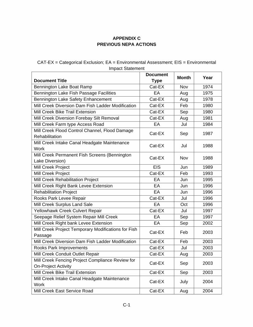
C-1
APPENDIX C
PREVIOUS NEPA ACTIONS
CAT-EX = Categorical Exclusion; EA = Environmental Assessment; EIS = Environmental Impact Statement
Document Title Document
Type Month Year
Bennington Lake Boat Ramp Cat-EX Nov 1974 Bennington Lake Fish Passage Facilities EA Aug 1975 Bennington Lake Safety Enhancement Cat-EX Aug 1978
Mill Creek Diversion Dam Fish Ladder Modification Cat-EX Feb 1980 Mill Creek Bike Trail Extension Cat-EX Sep 1980 Mill Creek Diversion Forebay Silt Removal Cat-EX Aug 1981 Mill Creek Farm type Access Road EA Jul 1984 Mill Creek Flood Control Channel, Flood Damage Rehabilitation
Cat-EX Sep 1987
Mill Creek Intake Canal Headgate Maintenance Work
Cat-EX Jul 1988
Mill Creek Permanent Fish Screens (Bennington Lake Diversion)
Cat-EX Nov 1988
Mill Creek Project EIS Jun 1989 Mill Creek Project Cat-EX Feb 1993 Mill Creek Rehabilitation Project EA Jun 1995 Mill Creek Right Bank Levee Extension EA Jun 1996 Rehabilitation Project EA Jun 1996 Rooks Park Levee Repair Cat-EX Jul 1996 Mill Creek Surplus Land Sale EA Oct 1996 Yellowhawk Creek Culvert Repair Cat-EX Jul 1997 Seepage Relief System Repair Mill Creek EA Sep 1997 Mill Creek Right bank Levee Extension EA Sep 2002 Mill Creek Project Temporary Modifications for Fish Passage
Cat-EX Feb 2003
Mill Creek Diversion Dam Fish Ladder Modification Cat-EX Feb 2003 Rooks Park Improvements Cat-EX Jul 2003 Mill Creek Conduit Outlet Repair Cat-EX Aug 2003 Mill Creek Fencing Project Compliance Review for On-Project Activity
Cat-EX Sep 2003
Mill Creek Bike Trail Extension Cat-EX Sep 2003 Mill Creek Intake Canal Headgate Maintenance Work
Cat-EX July 2004
Mill Creek East Service Road Cat-EX Aug 2004
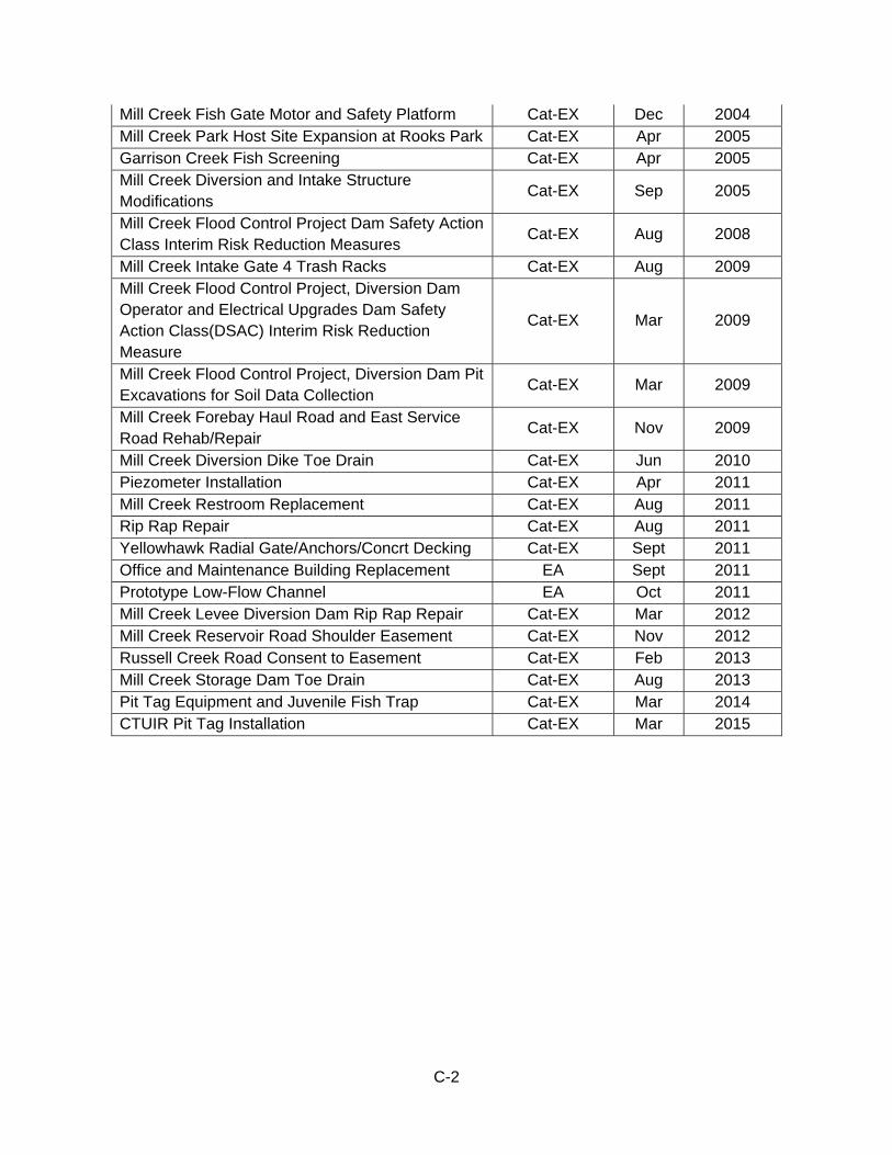
C-2
Mill Creek Fish Gate Motor and Safety Platform Cat-EX Dec 2004 Mill Creek Park Host Site Expansion at Rooks Park Cat-EX Apr 2005 Garrison Creek Fish Screening Cat-EX Apr 2005 Mill Creek Diversion and Intake Structure Modifications
Cat-EX Sep 2005
Mill Creek Flood Control Project Dam Safety Action Class Interim Risk Reduction Measures
Cat-EX Aug 2008
Mill Creek Intake Gate 4 Trash Racks Cat-EX Aug 2009 Mill Creek Flood Control Project, Diversion Dam Operator and Electrical Upgrades Dam Safety Action Class(DSAC) Interim Risk Reduction Measure
Cat-EX Mar 2009
Mill Creek Flood Control Project, Diversion Dam Pit Excavations for Soil Data Collection
Cat-EX Mar 2009
Mill Creek Forebay Haul Road and East Service Road Rehab/Repair
Cat-EX Nov 2009
Mill Creek Diversion Dike Toe Drain Cat-EX Jun 2010 Piezometer Installation Cat-EX Apr 2011 Mill Creek Restroom Replacement Cat-EX Aug 2011 Rip Rap Repair Cat-EX Aug 2011 Yellowhawk Radial Gate/Anchors/Concrt Decking Cat-EX Sept 2011 Office and Maintenance Building Replacement EA Sept 2011 Prototype Low-Flow Channel EA Oct 2011 Mill Creek Levee Diversion Dam Rip Rap Repair Cat-EX Mar 2012 Mill Creek Reservoir Road Shoulder Easement Cat-EX Nov 2012 Russell Creek Road Consent to Easement Cat-EX Feb 2013 Mill Creek Storage Dam Toe Drain Cat-EX Aug 2013 Pit Tag Equipment and Juvenile Fish Trap Cat-EX Mar 2014 CTUIR Pit Tag Installation Cat-EX Mar 2015
D-1
APPENDIX D
PERTINENT PUBLIC LAWS, REGULATIONS, AND POLICIES Laws applicable to recreation and public access. PL 78-534 Flood Control Act of 1944, 22 December 1944 PL 79-526 Flood Control Act of 1946, 24 July 1946 PL 88-578 Land and Water conservation Fund Act of 1965, 3 September 1964 PL 89-72 Federal Water Project Recreation Act of 1965, 9 July 1965 EO 11644 Use of Off-Road Vehicles on the Public Lands, 8 February 1972 (amended by EO 11989) EO 11989 Off-Road Vehicles in Public Lands, 24 May 1977 (amends EO 11644) EM 1110-1-103 Design for the Physically Handicapped, 15 October 1976 EM 1110-2-410 Design of Recreation Areas and Facilities Access and Circulation, 31 December 1982 EP 310-1-6 Graphic Standards Manual, December 1980 (Change 1) ER 1105-2-100 Planning Guidance Notebook, 22 April 2000 ER 1110-1-102 Design for the Physically Handicapped, 15 October 1976 ER 1110-2-400 Design of Recreation Sites, Areas, and Management Policies, 7 July 1972 (Change 1) ER 1120-2-400 Recreation Resources Planning, 1 November 1971 (Changes 1 through 3) ER 1130-2-400 Recreation - Resource Management of Civil Works Water Resource Projects, 1 October 1983 ER 1130-2-540 Project Operations - Environmental Stewardship Operations and Maintenance Guidance and Procedures, 15 November 1996 ER 1130-2-550 Recreation Operations and Maintenance Policies, 15 November 1996 revised 15 August 2002 ER 1165-2-400 Recreation Planning, Development, and Management Policies, 3 August 1970
E-1
APPENDIX E
ENVIRONMENTAL LAWS AND REGULATIONS
This list of Federal laws and Executive Orders may be applicable prior to implementing a project. 1. National Environmental Policy Act The NEPA of 1969 requires Federal agencies to integrate environmental values into their decision-making processes by considering the environmental impacts of their proposed actions and reasonable alternatives to those actions. To meet NEPA requirements when undertaking a major Federal action, Federal agencies, including the Corps, must prepare one of three evaluations depending if the proposed action could significantly affect the environment. The three analyses are Categorical Exclusion (CAT-EX), Environmental Assessment (EA), and Environmental Impact Statement (EIS). The list of previous NEPA actions is in Appendix C. A CAT-EX is an action that, either individually or cumulatively, does not have significant environmental impacts. Although exempt from NEPA documentation (EA or EIS), the Corps does document CAT-EX analyses and compliance with other applicable laws. A number of Federal agencies, including the Corps, have developed a list of actions normally excluded from environmental evaluation. [Refer to C.F.R. §230.9: E.R. 200-2-2]. If an action is not categorically excluded from NEPA compliance, an EA is prepared to determine if the proposed action would significantly affect the environment. If the answer is negative, the Corps issues a Finding of No Significant Impact (FONSI). The FONSI may address measures the Corps will take to reduce or mitigate potentially significant impacts. In certain circumstances, Federal agencies may choose to prepare an EIS without first preparing an EA. If the EA determines that environmental consequences may be significant, a draft EIS is prepared. An EIS is a more detailed evaluation of the proposed action and alternatives. The public, Federal agencies, and outside parties may provide input into the preparation of an EIS. The Corps is required to make diligent efforts to involve the public in the NEPA process, including holding public meetings and allowing for a designated comment period. A final EIS is prepared that incorporates public comments and the Corps’ response to those comments. After a 30-day waiting period, the Corps issues a public Record of Decision addressing how the findings of the EIS, including consideration of alternatives, were incorporated into the decision-making process.
E-2
2. Endangered Species Act The ESA establishes a national program for the conservation of endangered and threatened species and their habitat. In accordance with Section 7(a) (2) of the ESA of 1973, as amended, Federally-funded, constructed, permitted, or licensed projects must take into consideration impacts to Federally listed or proposed threatened or endangered species. 3. Clean Water Act The Clean Water Act (CWA) sets national goals and policies to eliminate the discharge of water pollutants into navigable waters, regulate the discharge of toxic pollutants, and prohibit the discharge of pollutants from point sources without permits. 4. Clean Air Act The Clean Air Act (CAA) of 1970, as amended, established a comprehensive program for improving and maintaining air quality throughout the United States. Its goals are achieved through permitting of stationary sources, restricting the emission of toxic substances from stationary and mobile sources, and establishing National Ambient Air Quality Standards. Title IV of the CAA includes provisions for complying with noise pollution standards. 5. National Historic Preservation Act Section 106 of the National Historic Preservation Act requires that Federally-assisted or Federally permitted projects account for potential effects to sites, districts, buildings, structures, or objects included in or eligible for inclusion in the National Register of Historic Places. 6. Native American Graves Protection and Repatriation Act The protection of Native American and Native Hawaiian human remains and funerary objects is covered by this Act. In addition, the Act governs rights of ownership and control of Native American cultural items, human remains, and associated funerary objects to Native Americans. It also provides for the protection and repatriation of Native American human remains and funerary objects that have been culturally affiliated with a Federally-recognized Indian tribe. 7. Magnuson-Stevens Fishery Conservation and Management Act As amended, this management Act (PL 94-265), established procedures designed to identify, conserve, and enhance essential fish habitat for fisheries regulated under a Federal fisheries management plan. Federal agencies must consult with the National Marine Fisheries Service (NMFS) on all proposed actions authorized, funded, or carried out by the agency that may adversely affect this Act.

E-3
8. Fish and Wildlife Coordination Act The Fish and Wildlife Coordination Act of 1934 states that Federal agencies involved in water resource development will consult with the USFWS and the state agency administering wildlife resources concerning proposed actions or plans. 9. Migratory Bird Treaty Act The Migratory Bird Treaty Act provides the USFWS with regulatory authority to protect species of birds migrating within and outside the United States. This Act prohibits the harming, harassment, and taking of protected species except as permitted by the USFWS. 10. Bald and Golden Eagle Protection Act This law provides for the protection of bald eagles and golden eagles by prohibiting, except under certain specified conditions, the taking, possession, and commerce of these birds. The 1972 amendments increased penalties for violating provisions of the Act or regulations issued pursuant thereto, and strengthened other enforcement measures. Rewards are provided for information leading to the arrest and conviction for any violation of the Act. 11. Executive Order 11990–Protection of Wetlands This EO requires Federal agencies to protect wetland habitats. 12. Executive Order 12898–Environmental Justice This EO requires Federal agencies to consider and minimize potential impacts to subsistence, low income, or minority communities. The goal is to ensure that no person or group of people shoulder a disproportionate share of negative environmental impacts resulting from the execution of the country’s domestic and foreign policy programs. 13. Executive Order 13175–Consultation and Coordination with Indian Tribal Governments This EO sets forth guidelines for all Federal agencies to 1) establish regular and meaningful consultation and collaboration with Indian tribal officials in the development of Federal policies that have tribal implications; 2) strengthen the United States government-to-government relationships with Indian tribes; and 3) reduce the imposition of unfunded mandates on Indian tribes.

E-4
14. State/Local Regulations On a case-by-case basis, state or local laws and ordinances may be applicable to any potential project implementation based on aspects of the individual task. A state water quality certification is an example of a potential instance where a state permit or authorization may be a requirement for project implementation.
F-1
APPENDIX F
ENVIRONMENTAL OPERATING PRINCIPLES In 2003, the Corps adopted seven environmental operating principles (EOPs). The purpose of the operating principles is to guide “the ways in which the U.S. Army Corps of Engineers missions must be integrated with natural resource laws, values, and sound environmental practices” (Corps, 2003). The Corps is integrating the EOPs into all business activities. The following paragraphs explain how the MCMP fulfills each EOP. EOP 1. Strive to achieve environmental sustainability. An environment maintained in a healthy, diverse, and sustainable condition is necessary to support life. Collaborative efforts with Federal and state agencies, and state and local governments, are implemented wherever possible for development, management, and monitoring of resources at Corps reservoir projects. Sustainable development is ensured into the future through environmental stewardship, epitomized by resource objectives identified for Mill Creek, and development needs that are consistent with those resource objectives. Monitoring, including inspections, allows feedback to determine whether adaptive management efforts are needed to ensure the balanced human environment envisioned in the MP. The Corps’ multidisciplinary staff conducts periodic inspections of each area, structure, and facility used to operate and maintain the project to ensure management and development activities are in accordance with Corps-approved plans and current regulations. The MP identifies sustainable conceptual guidelines for future development. These are based on contribution to the objectives of society (regional plans/needs and expressed public desires) now and in the future (forecasted for the next 15 to 20 years) that maintains their ecological, environmental, and hydrological integrity (consistent with project purposes, NEPA, and other laws and regulations). The MP includes historic, current, and forecasted future environmental and economic considerations. The plan discusses various resource objectives and development needs that must improve the quality of life by meeting regional recreational needs, while protecting biological, geological, cultural, and historical resources. Planning, design and construction, and operation and maintenance function in an integrated manner to ensure maximum quality of life for present and future generations.
F-2
EOP 2. Recognize the interdependence of life and the physical environment, and consider environmental consequences of Corps programs and activities in all appropriate circumstances. In the MP, the Corps considers the interrelationships among all factors, including activities of humans, habits and habitats of fish and wildlife, in determining the most suitable land classification and types and levels of development for Mill Creek. The MP strives to secure adequate information on the environmental consequences of all reasonable alternatives, in order to objectively assess them in the decision process by identifying the most appropriate land classifications and most suitable types and levels of development. The subsequent environmental compliance requirements will further assess the impacts of individual development projects on the resource. EOP 3. Seek balance and synergy among human development activities and natural systems by designing economic and environmental solutions that support and reinforce one another. The conceptual guidelines developed during preparation of the MP seek a balance and synergy among human development activities and natural systems. Considering Mill Creek from a holistic perspective created solutions that provide public access opportunities that minimize harmful impacts and support the natural systems of the area. EOP 4. Continue to accept corporate responsibility and accountability under the law for activities and decisions under our control that impact human health and welfare and the continued viability of natural systems. The MP recommendations considered existing environmental conditions and the impacts future development will have on the resource. Because the Plan recommends conceptual guidelines for development and not specific areas for specific activities, each future development will have to fulfill the requirements of NEPA. The MP will aid in the NEPA process by describing existing environmental conditions, including air quality, water quality, vegetation, fish and wildlife, and threatened and endangered species. Future developments will have to be evaluated regarding the effects of the project or activity on the environment. The conceptual recommendations set forth in the MP must also be in compliance with other applicable environmental and cultural resource laws and executive orders, including the CAA, CWA, ESA, Archaeological Resources Protection Act, Fish and Wildlife Coordination Act, along with others as they apply.
F-3
EOP 5. Seek ways and means to assess and mitigate cumulative impacts to the environment; bring systems approaches to the full life cycle of our processes and work. The cumulative impacts to the environment resulting from visitation to Corps recreation areas will continue to be monitored and negative impacts mitigated where necessary. Recreation areas will be designed and located to provide wildlife habitat in appropriate areas. In addition, project staff will evaluate the construction of any new recreation facilities under NEPA to see if they are categorically excluded from further analysis or require an environmental assessment (EA) to determine their impact to the environment. The Corps will offer consultation to Tribal governments for site specific development proposals. The Corps and non-Federal lessees will manage recreation areas in accordance with all pertinent environmental laws. EOP 6. Build and share an integrated scientific, economic, and social knowledge base that supports a greater understanding of the environment and impacts of our work. The Mill Creek project staff coordinates extensively with other agencies and organizations to develop integrated scientific, economic, and social knowledge bases that support a greater understanding of environmental impacts. The Corps is also active in educating the public about environment impacts. One of the project wide resource objectives at Mill Creek is to provide public education about the history of the area, Mill Creek project resources, and the Corps’ role in developing and managing these resources. EOP 7. Respect the views of individuals and groups interested in Corps activities, listen to them actively, and learn from their perspective in the search to find innovative win-win solutions to the nation's problems that also protect and enhance the environment. The Corps has been proactive in respecting the views of individuals and groups interested in the MP. During 2015, the MP team held a public scoping meeting designed to gather local insights and concerns regarding natural resources and recreational activities at the Project. Additionally, public comment cards and a website were developed to provide an opportunity to ask questions or make comments concerning the use of the project.
G-1
APPENDIX G
ABBREVIATIONS AND ACRONYMS
°C Degrees Celsius °F Degrees Fahrenheit CAA Clean Air Act CAT-EX Categorical Exclusion CFR Code of Federal Regulations Corps U.S. Army Corps of Engineers CWA Clean Water Act DM Design Memorandum EA Environmental Assessment EIS Environmental Impact Statement EM Engineer Manual EP Engineer Pamphlet EO Executive Order EOP Environmental Operating Principle EP Engineer Pamphlet ER Engineer Regulation ESA Endangered Species Act ESA Environmentally Sensitive Area FONSI Finding of No Significant Impact FWWTR Fort Walla Walla Timber Reserve GIS Geographic Information System ISOP Interpretive Services and Outreach Program LCU Land Classification Unit MP Master Plan MRM Multiple Resource Management MU Management Unit NEPA National Environmental Policy Act NMFS National Marine Fisheries Service NRCS National Resources Conservation Service OMBIL Operation Business Information Link OMP Operational Management Plan PL Public Law RM River Mile RO Resource Objective SCORP Statewide Comprehensive Outdoor Recreation Plan USACE United State Army Corps of Engineers USFWS U.S. Fish and Wildlife Service VERS Visitation Estimation& Reporting System WWC Walla Walla County WDFW Washington Department of Fish and Game