Embed Size (px)
Citation preview
Military activities on Rome’s frontier:The evidence of aerial archaeology
Martin Gojda
1. INTRODUCTION
On the occasion of the international conference (the present proceedings representing its publica-tion output) inspired by the bimillenial anniversary of an alleged military campaign of the Romansagainst the Markomans in AD 6, I have attempted to prepare a brief overview of the way in whichthe current level of our knowledge of military activities on Rome’s frontier has been shaped by aerialarchaeology. The proposed work is an introduction to this area, intended to serve basic orientation inthe history and contemporary trends in the field of aerial prospecting and documentation of Rome’sfrontier. Therefore, it is not a summary of all the projects and publications ever devoted to the subject.The contribution focuses on three geographical areas – Near East/North Africa, Great Britain andCentral Europe (here, greatest attention is paid to the more recent discoveries of archaeologically trace-able evidence of Rome’s military expansion on the central Danube, or more precisely the territory offormer Czechoslovakia). The chapters arranged in this order simultaneously express the time sequencein which the aerial survey of military installations on Limes romanus unfolded.
2. AERIAL SURVEY OF THE DESERT FRONTIER OF THE ROMAN EMPIRE:NEAR EAST AND AFRICA
The present state of knowledge makes it impossible for us to pinpoint a single country whereaerial archaeology was born. Similarly, it is very difficult to name a single person to have laid thefoundations of the field. It would be more precise to ask which part of the world saw the realizationof the first purposeful aerial survey aimed at identifying unknown archaeological monuments, whomost markedly shaped the content of the field in its beginnings, who influenced to the greatest extentthe form of aerial archaeology from the theoretical and methodological point of view, and who, usingaerial survey, collected information that had a fundamental impact on the archaeological knowledgeof historical landscape and peoples lifes in the past. If we proceed in this manner, we will come to theconclusion that in its beginnings, the field had been formed by several personalities whose generalcontribution to aerial archaeology was, besides their own abilities and knowledge, significantly influ-enced by the technical potential of their equipment (especially aircraft and cameras) as well as thegeographical characteristics of the landscapes in which the survey was being conducted. Thus, twovery different and distant geographical areas became the cradle of aerial archaeology: the desert anddry steppe landscapes of the Near East (especially East Mediterranean, Sinai, Levant, Mesopotamia),later also the more distant areas of the Middle East (Iran) and North Africa on the one hand, andWestern Europe (England) of the mild Atlantic climate on the other hand.
1
Vladimír Salač – Jan Bemmann (Hrsg.): Mitteleuropa zur Zeit Marbods. Praha – Bonn.xxx–xxx
A personality with undeniable primacy in the area of methodology of aerial archaeology wasO. G. S. Crawford (1886–1957). He was the first to publish his discoveries and to define by their meansthe principles underlying the identification of archaeological monuments in the field. Simultaneously,he introduced to specialized literature the procedures of gaining and processing field data (especiallyCrawford 1924; Crawford – Keiller 1928). The truth is, however, that this came about roughly twentyyears after aerial imaging had begun to take important part in the photographic documentation ofarchitectural and archaeological monuments preserved on the earth’s surface in more or less destroyedforms as well as in the discoveries of ancient monuments which had been totally unknown or knownsolely from written records (e.g. ancient Samara, see below).
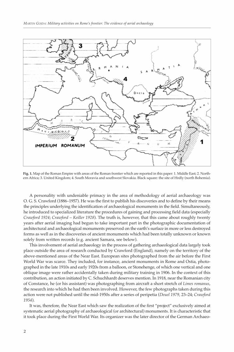
This involvement of aerial archaeology in the process of gathering archaeological data largely tookplace outside the area of research conducted by Crawford (England), namely on the territory of theabove-mentioned areas of the Near East. European sites photographed from the air before the FirstWorld War was scarce. They included, for instance, ancient monuments in Rome and Ostia, photo-graphed in the late 1910s and early 1920s from a balloon, or Stonehenge, of which one vertical and oneoblique image were rather accidentally taken during military training in 1906. In the context of thiscontribution, an action initiated by C. Schuchhardt deserves mention. In 1918, near the Romanian cityof Constance, he (or his assistant) was photographing from aircraft a short stretch of Limes romanus,the research into which he had then been involved. However, the few photographs taken during thisaction were not published until the mid-1950s after a series of peripetia (Deuel 1979, 23–24; Crawford1954).
It was, therefore, the Near East which saw the realization of the first “project” exclusively aimed atsystematic aerial photography of archaeological (or architectural) monuments. It is characteristic thatit took place during the First World War. Its organizer was the later director of the German Archaeo-
2
MARTIN GOJDA: Military activities on Rome’s frontier: The evidence of aerial archaeology
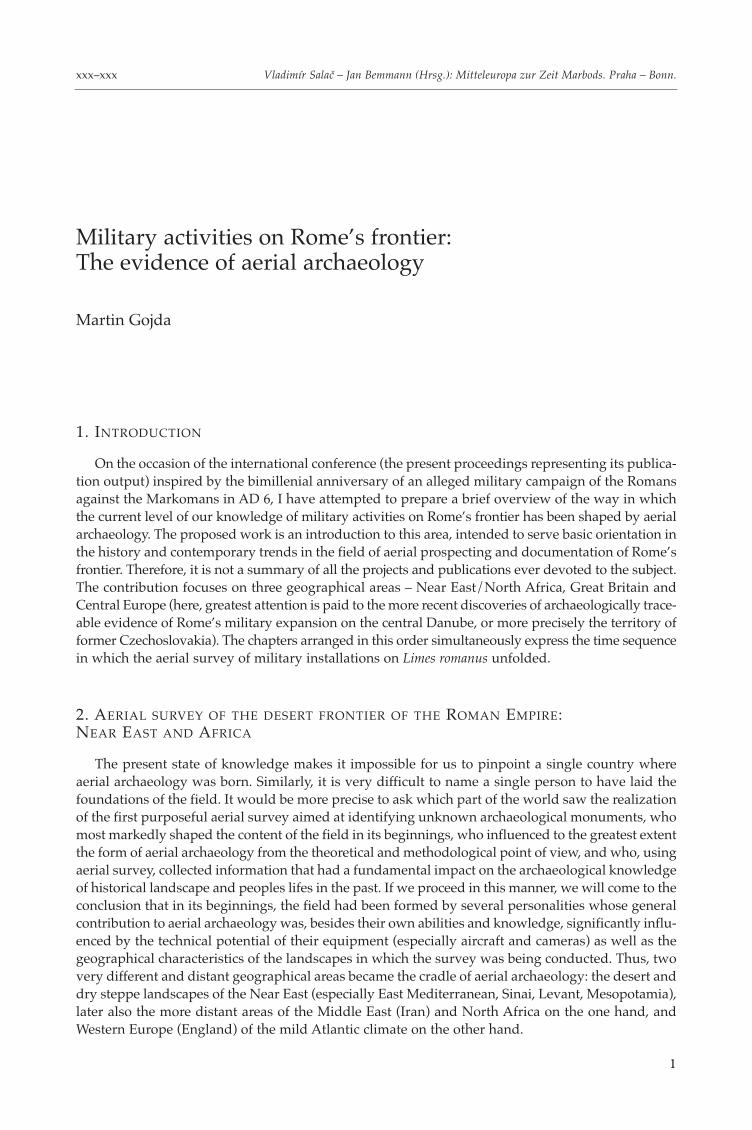
Fig. 1. Map of the Roman Empire with areas of the Roman frontier which are reported in this paper: 1. Middle East; 2. North-ern Africa; 3. United Kingdom; 4. South Moravia and southwest Slovakia. Black square: the site of Hrdly (north Bohemia).
logical Institute T. Wiegand, who initiated as part of the activities of the Command for the Near EastMonument Protection (the so-called Denkmalschutzkommando, founded by himself) the repeatedphotographing of the ruins of ancient cities and many other monuments and published the photo-graphs taken in a representative volume shortly after the war (Wiegand 1920). Identical significancecan be ascribed to the activities of an English army officer G. A. Beazeley, who was conducting groundand aerial research in Mesopotamia during the war, having identified e.g. the ruins of an extensiveearly medieval city of Old Samara. He published his wartime research shortly after the war, and it isnot without significance that herein he regards aerial archaeology – probably for the first time in thehistory of archaeology – as an independent field (Beazeley 1919; 1920). In addition, it is impossible toomit French pilots whose pictures of ancient monuments were taken on the impetus of L. Rey as earlyas 1915 over one of the World War fronts in Northern Greece (Kennedy – Riley 1990, 48).
3
Vladimír Salač – Jan Bemmann (Hrsg.): Mitteleuropa zur Zeit Marbods. Praha – Bonn.
Fig. 2. Aerial photographtaken in 1918 of a section ofthe Limes romanus in currentRomania. Arrows indicatesmall camps sticked to thefrontier wall/ditch (afterCrawford 1954).
In these early days of aerial archaeology during the First World War, the attention of aerial militaryobservers and photographers had already been captured by the remains of Roman objects of bothcivilian and, above all, military character. However, it was not until the end of the First World War thatresearchers began to focus on more systematically conducted research into the eastern frontier of theRoman Empire (stretching between the Black Sea and the Red Sea), striving to study it as a certainmutually interconnected (structured) system spanning up to three thousand kilometres.
While in the northern half of this frontier line, in eastern Turkey, very few Roman monuments havebeen preserved to this day (although there are written records of a large number of military installa-tions, these were mostly dismantled for building material by the permanently settled peasants farm-ing the fertile local valleys), the exact opposite is true for its southern part. This so-called “desertfrontier” of the Roman Empire, stretching for roughly 1200 kilometres from the Middle Tigris acrossSyria and Jordan to the eastern edge of the Sinai Peninsula, was until recently inhabited by nomads,whose migratory way of life caused much less damages the remains of buildings of Roman originethan the activities of peasants in the north had done (Kennedy – Riley 1990, 14). The interest in study-ing the relics of the Roman frontier in this area dates back to the pre-war period, when e.g. A. Musil,a researcher and traveller of Czech origin, was active here (Musil 1928).
Logically, it was aerial survey, a method which had undergone fundamental development duringthe First World War that offered itself for the study of this very part of the eastern Roman frontier.Its utilization was very swift to come. In desert areas, it was adjusted to the purposes archaeologicalsurvey by another founder of aerial archaeology – Père Antoine Poidebard (1878–1955), a French Jesuitpriest and professor at Beirut University, who, aided by the French Air Force, had carried out extensiveaerial surveys and photographing of ancient monuments in the 1920s and 1930s. He commenced his
4
MARTIN GOJDA: Military activities on Rome’s frontier: The evidence of aerial archaeology
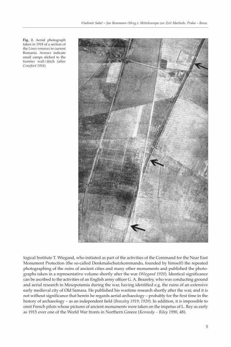
Fig. 3. Roman military installations in the Middle East Syria, Iraq and Jordan discovered and documented by P. A. Poidebardand A. Stein. Other important ancient sites of the area are also indicated (after Kennedy – Riley 1990).
aerial survey activity in 1925, but it was not until fouryears later that he began to focus on the systematicsurvey of the whole course of Rome’s frontier in Syria.The results of his research were published in the pro-fessional journal Syria (in 1927–1931) and in a 1934monograph, a two-volume work containing a largenumber of vertical and oblique photographs of most-ly very high technical quality, taken by him and hisco-pilots from the cockpit of a double-wing aircraftPotez 25 (Poidebard 1934). His activities continued in1934–1937 over the territory beyond Rome’s frontier.He published the results achieved in this period aslate as the mid-1940s (Mouterde – Poidebard 1945).
As an important aspect of his 1934 work we canregard the text of the first chapter, devoted to themethods of aerial survey in archaeology as he devel-oped them in the specific environment of the ariddesert character in which he had been conducting hisresearch (e.g. the technique of backlight imaging fromlow altitudes or ground survey of sites immediatelyafter their identification and subsequent landing intheir vicinity; for more detail see Kennedy – Riley 1990,56–63). As most Roman military monuments are stillpreserved here in terrain relief, these objects areclearly identifiable by means of the so-called shadowmarks, to who’s detecting and photographingPoidebard paid the greatest attention (some sites, however, are also highlighted by different colour-ing of the vegetation in his photographs). Aerial survey conducted in such landscape in low lighthad yielded results that would hardly be achievable in a different way (with respect to the varieddegree of destruction in a given environment type, locating the monuments or tracking their over-all size is not always guaranteed during surface survey). Thus, after Crawford, Poidebard was thefirst to have made a creative contribution to the general development of the methodology of aerialarchaeology. Incidentally, both personalities met in the late 1920s, precisely in 1927 (as recorded byPoidebard), and probably also a year later, when Crawford was gathering aerial photographs ofancient monuments taken by British Air Force pilots over the territory of today’s Jordan, Israel andEgypt (Kennedy – Riley 1990, 51–52).
Poidebard devoted his effort to practically all types of military objects built by the Romans on theeastern frontier of their Empire, i.e. communications, large military camps (castra), smaller fortressesand watchtowers (castellum, burgus) as well as garrisons built inside large urban settlements. Theaerial photographs of the individual sites and especially the map published by Poidebard (1934),fundamentally changed the contemporary state of knowledge of Rome’s desert frontier. For the firsttime ever, partial components – more or less preserved ruins of military buildings – were assembledinto a whole that displayed an elaborate conception of Roman defence strategy and its practical real-ization. This first great success of aerial archaeology, applied during research into Rome’s militaryactivities, was almost instantly given a positive reception and was highly valued by professionals,mostly in the form of the reviews of Poidebard’s life work published in specialized press.
The research into the desert frontier of the Roman Empire in the interwar period was continued bythe Budapest-born Hungarian orientalist of Jewish origin Aurel Stein (1862–1943), who had studiedSanskrit and Persian in Germany. After his studies he began to work in England, soon acquiring a uni-versity position in today’s Pakistan, where he studied old manuscripts. He became famous above allfor his research conducted in the mountainous areas of Central Asia and eastern China, to which heorganized three expeditions in 1901–1916. Their purpose was terrain survey, targeting and archaeolog-
5
Vladimír Salač – Jan Bemmann (Hrsg.): Mitteleuropa zur Zeit Marbods. Praha – Bonn.
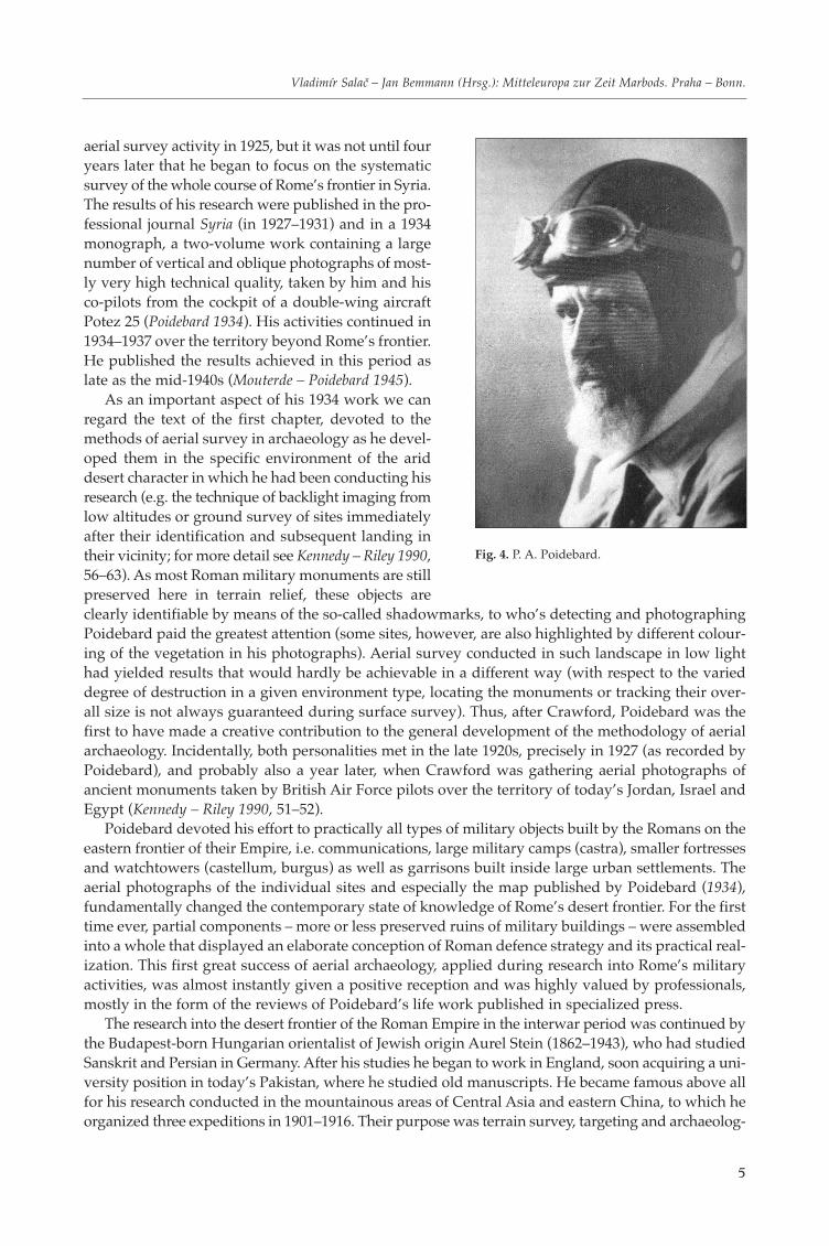
Fig. 4. P. A. Poidebard.
ical excavations of sacral structures, in which he especially looked for wooden tablets with preservedtexts. His achievements earned him ennoblement in 1912.
He had been aware of the importance of aerial survey since the end of the First World War. Afterretiring in the late 1920s, his attention turned to the Near East, especially the eastern Roman frontier.
6
MARTIN GOJDA: Military activities on Rome’s frontier: The evidence of aerial archaeology
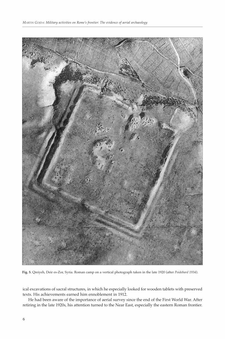
Fig. 5. Qreiyeh, Deir es-Zor, Syria. Roman camp on a vertical photograph taken in the late 1920 (after Poidebard 1934).
He was strongly influenced by Poidebard’s aerial and ground surveys in Syria. After long protrac-tions, he finally managed to launch an extensive expedition in 1938–1939 with the support of theBritish Air Force, aimed at continuing the research into the eastern Roman frontier where Poidebardhad left off (Stein 1940). The territory was that of northern Iraq, or Mesopotamia on the high andmiddle Euphrates and Tigris. In the final stage of the expedition, Stein got as far as the southern partof Rome’s frontier (today’s Jordan and Israel). In addition to a double-wing universal aircraft VickersVincent with three cockpits (which could accommodate Stein and a photographer besides the pilot),the expedition also possessed two cars used for terrain verification of the newly-discovered monu-ments. Contrary to Poidebard, Stein was not as interested in the procedures and experiments toimprove the quality of aerial photographs taken in the desert environment. Moreover, his interestwas focused on those parts of Rome’s fortified frontier whose masonry was well-preserved; unlikePoidebard, he did not take delight in seeking out sites that were almost or totally buried and iden-tifiable on the surface by means of shadowmarks or cropmarks. He may have been discouraged bythe vastness of the territory on which he was planning to document and map Roman roads and mil-itary installations in the situation of his advanced age – in 1939 he was already 77 years old (Kennedy –Riley 1990, 63–64). Stein’s reports, texts and notes from the survey in Iraq and Jordan (so-called “LimesReport“) were collected and published in a two-volume edition more than 40 years after his death(Gregory – Kennedy 1985). The negatives made during this campaign are stored at the Institute ofArchaeology in London.
For a long time after 1945, no projects aimed at aerial survey of the Near East were undertaken.The geopolitical situation in this part of the world changed radically after the Second World War,which meant long-term stagnation for aerial archaeology. Most regimes in the Near East countries
7
Vladimír Salač – Jan Bemmann (Hrsg.): Mitteleuropa zur Zeit Marbods. Praha – Bonn.
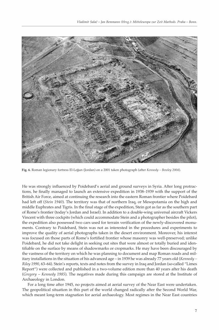
Fig. 6. Roman legionary fortress El-Lejjun (Jordan) on a 2001 taken photograph (after Kennedy – Bewley 2004).
not only made conducting aerial prospection and photography impossible, but they also frequentlydenied access to the archives of aerial photographs taken mostly by the armed forces for mappingpurposes. A notable exception in this situation was represented by the Kingdom of Jordan, rankingamong the world’s richest countries in terms of the number and variety of archaeological heritage.In the 1970s, the country enabled access to its military archives of special, i.e. also aerial photographs –a similarly obliging step was made by no other country in the region. A certain role in Jordan‘s pos-itive approach to aerial survey was possibly played the British, under whose mandate the country’sterritory came in the interwar period – at that time, the United Kingdom had just become a super-power in the field of aerial archaeology (Nesbit 2003).
The leading researcher of the post-war period systematically dealing with the problem of Limesromanus in the East is David Kennedy, Professor of Archaeology of the Roman period at the Univer-sity of Western Australia (former Boston University). In the 1980s he joined forces with s D. Riley,an ex-RAF war pilot, who became renowned after the Second World War as a leading English rep-resentative of aerial archaeological survey (Riley 1987; see also Kennedy ed. 1989). The result of theirco-operation was a monograph devoted to Rome’s frontier in the desert regions of the Near East,repeatedly cited in this contribution (Kennedy – Riley 1990). In the 1990s, Kennedy managed to gainfrom the above-mentioned military photo-archive four thousand negatives of vertical aerial photo-graphs of the western part of Jordan, which he subjected to analysis and interpretation. In these he wasable to identify as many as 25 thousand sites with traces of ancient settlement activities. This figurerepresents three times the number of sites recorded in the Jordan state archaeological database andinformation system (Kennedy – Bewley 2004, 25, 53).
The last-but-one campaign in the Near East was the aerial imaging of Israel in the years 1990–1992.In co-operation with B. Isaac and M. Gichon, it was conducted by the above-mentioned EnglishmanD. Riley (Kennedy – Bewley 2004, 54).
8
MARTIN GOJDA: Military activities on Rome’s frontier: The evidence of aerial archaeology
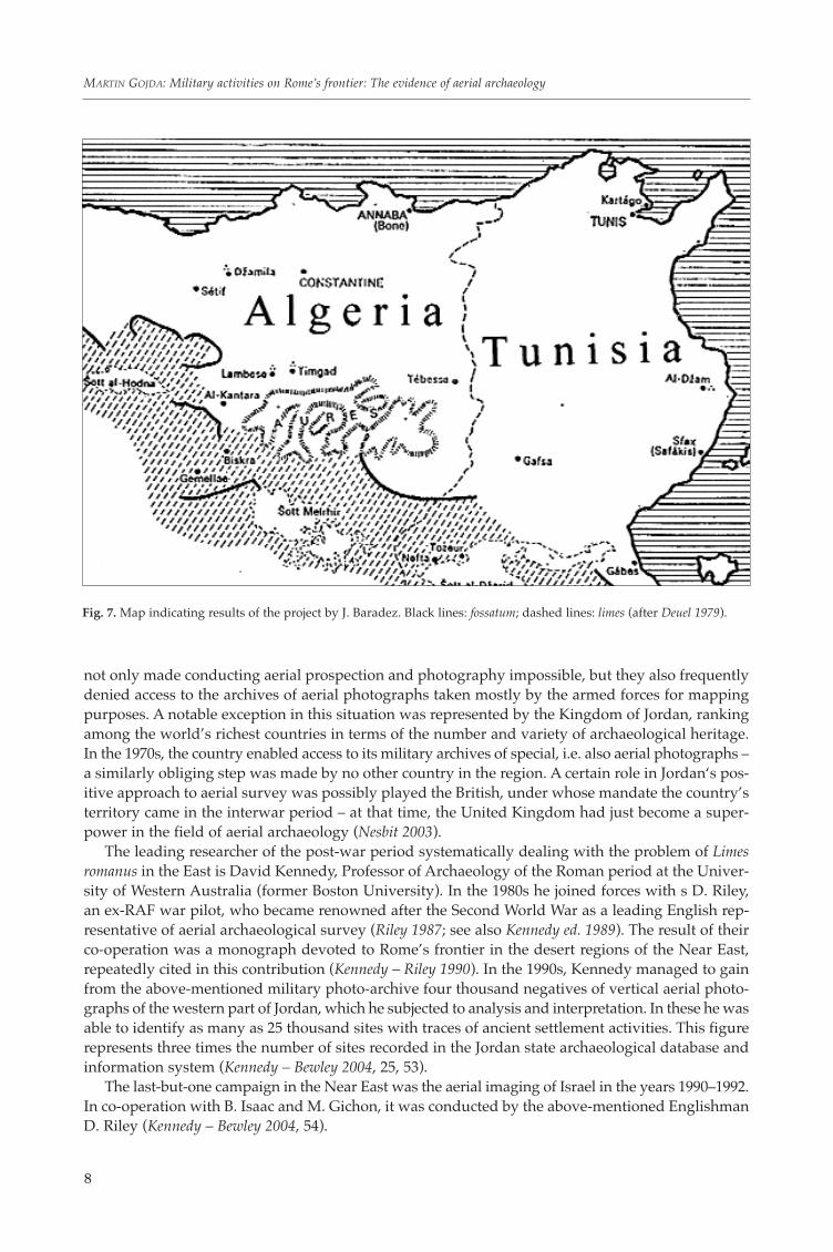
Fig. 7. Map indicating results of the project by J. Baradez. Black lines: fossatum; dashed lines: limes (after Deuel 1979).
The most recent aerial survey in the Near East, aimed among others at the documentation of relicsof Rome’s desert frontier, was started in 1997. Together with D. Kennedy it has been conducted byR. Bewley, one of the leading personalities of current British aerial archaeology. During the first stageof the project in 1997–2003 these specialists, aided by Jordan air forces, took photographs of high doc-umentation and technical quality of about 400 sites. Every year in late summer they fly over Jordan,the results having been published in a well-presented monograph accompanied by over two hundredcolour aerial photographs (Kennedy – Bewley 2004).
The other area of extreme desert character that has become the centre of attention of archaeologistsand historians interested in the study of Rome’s limes is the north African – i.e. Southern – frontierof the Roman Empire. In this environment, where, due to the movement of sand masses (frequentdesert storms), the recognition of half-decayed and buried remains of human settlement activities isoften more difficult than in the Near East, aerial survey has found significant application as well.In Libya, attempts at it were made by the Englishman R. G. Goodchild, in Tunisia by the FrenchmanC. Saumagne – besides the Roman frontier they were also involved in the documentation and map-ping of the remains of centuriation systems (Deuel 1979, 106). To the greatest extent, however, it wasdeveloped by the French military pilot Jean Baradez (1895–1969). During a visit to Algeria in 1937P. A. Poidebard convinced Baradez of the importance of air photographs for mapping sites andmonuments in that country (Jones 2000, 50). In the 1940s he focused his interest on the history ofRome’s frontier in the area of the former provinces of Mauretania (Saharan part of today’s Algeria).In his work he fully utilized his experience of an aerial surveyor (he had worked as a balloon observerbefore the First World War, in the interwar period he was trained as a military pilot). Contrary to
9
Vladimír Salač – Jan Bemmann (Hrsg.): Mitteleuropa zur Zeit Marbods. Praha – Bonn.
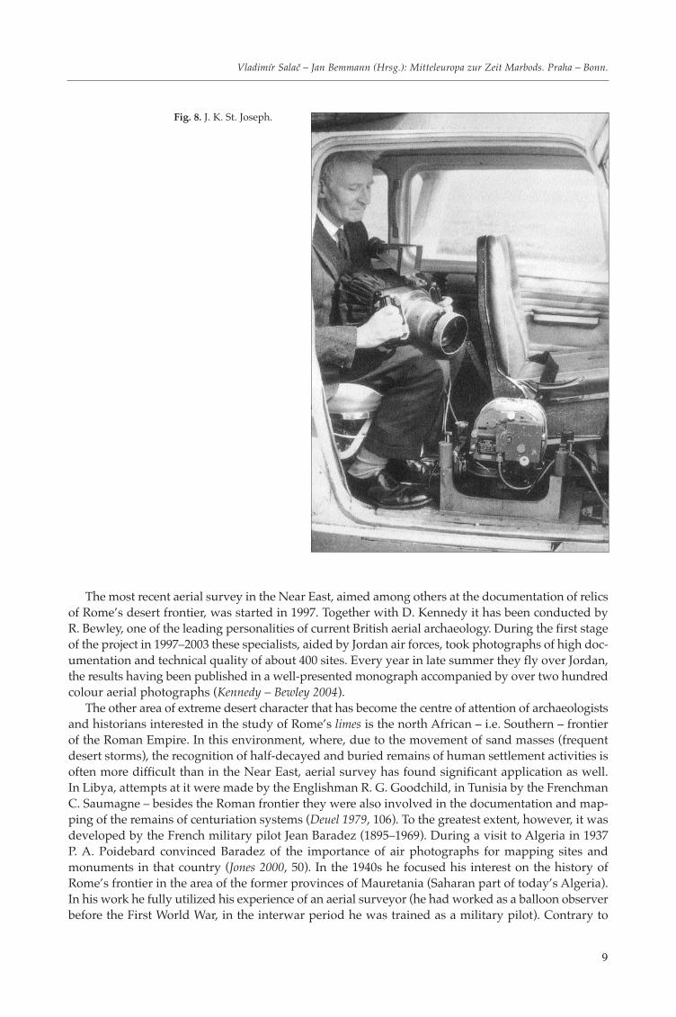
Fig. 8. J. K. St. Joseph.
Poidebard, who had also intended to deal with the topic of African desert frontier (after several sur-vey activities in Algeria in 1937, however, he had to give up such a project for objective reasons), hehad vertical aerial photographs as his main source of research. These comprised a series of more thana hundred photographs taken from the altitude of 4000 kilometres, the analysis of which revealeda large number of miscellaneous military installations fitting into the elaborate scheme of the frontiersystem. Later on, he also included in his project aerial prospection from low altitudes and terrainsurvey of the discovered monuments.
Baradez published the results of his north-African research in the late 1940s (Baradez 1949). Bydoing so, he fundamentally shifted the knowledge concerning the defence system of the southernfrontier of the Roman Empire, which consisted of two components referred to by historical recordsas limes and fossatum. The overwhelming majority of the relics of the system revealed by Baradez hadbeen hitherto unknown.
Similarly to Poidebard’s work in the Near East, Baradez’s effort in Algeria also yielded a pictureof the overall structure of the local frontier zone. In this case, it was the mutual link between the rela-tively wide line of the frontier area with a series of miscellaneous military bases (limes) and the systemof defensive ditches (fossatum), which complemented the frontier in strategically important areas onits northern (inner) edge. Contrary to that, previous ideas placed the system of ditches in the southernpart of the frontier, and historians regarded it as a physical obstacle that would have to be overcomeby the potential enemy.
The survey of military installations in the desert and dry steppe areas through which Rome’seastern and southern frontier ran can thus be described as the most important part of the research,with aerial photography in its early days having proved its viability and usefulness.
10
MARTIN GOJDA: Military activities on Rome’s frontier: The evidence of aerial archaeology
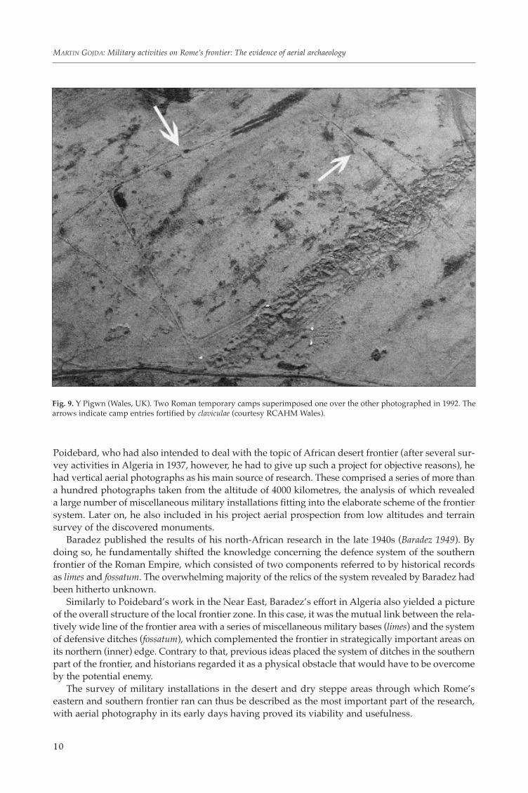
Fig. 9. Y Pigwn (Wales, UK). Two Roman temporary camps superimposed one over the other photographed in 1992. Thearrows indicate camp entries fortified by claviculae (courtesy RCAHM Wales).
The projects realized in the 1920s–1940s in the Near East and North Africa fundamentally shiftedthe knowledge of ancient Roman history as well as the possibilities afforded by the view from abovefor understanding complex relations among ancient relics on the surface of the earth.
3. AERIAL SURVEY OF THE NORTHERNMOST FRONTIER OF THE ROMAN EMPIREAND MILITARY INSTALLATIONS IN THE PROVINCE OF BRITANNIA
It is insular Britain that can without much hesitation be described as the area bearing traces ofRoman military activities that has most thoroughly been mapped by aerial survey. In the northwestoutpost of the Empire, at the opposite end of the imperial world to the one discussed in the previouschapter, so many places connected with the military conquest of new territories and their subsequentdefence were discovered that a similar situation (with respect to the extensive area of Britain, or moreprecisely England, Scotland and Wales) from another comparable territory is unknown. The sheernumber of military camps/fortresses stated in literature that are known from here (about 250 auxil-
11
Vladimír Salač – Jan Bemmann (Hrsg.): Mitteleuropa zur Zeit Marbods. Praha – Bonn.
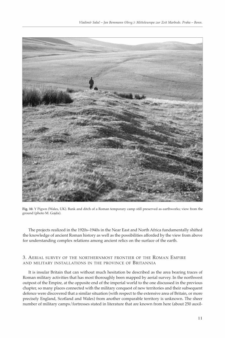
Fig. 10. Y Pigwn (Wales, UK). Bank and ditch of a Roman temporary camp still preserved as earthworks; view from theground (photo M. Gojda).
iary camps in Britain as opposed to 200 in Germany: Musil 2000, 110; almost 350 temporary camps:Wilson 1980, 10) proves this quite clearly.
The study of very few periods in British history has been so markedly influenced by aerial surveythan the epoch of Roman Britain. Most of the above-mentioned temporary camps were either discov-ered during aerial survey, or aerial photographs as a way of effective documentation have brought keyinformation about the character of particularly those camps that have been preserved as earthworksor ruined monuments. The history of aerial archaeology of Roman Britain (or military campaigns andfortification works organized by Roman troops) began to be written by O. G. S. Crawford in the inter-war period. He had an opportunity to learn about some aspects of Roman military installations fromthe air during his journey to the Near East in the late 1920s. These installations began to interest himin the years preceding the outbreak of the Second World War. As early as the 1930s he was conductingaerial prospecting in the northern half of England and the south of Scotland; without much success,however. It was not until 1939 that he organized another campaign combining ground survey withaerial prospecting. He acquired a new co-worker, J. K. St. Joseph (1912–1994), a young geologist(a Cambridge graduate devoting all his life to work at this university) with a great interest in thearchaeology of Roman Britain, who had gradually evolved into one of the leading aerial archaeolo-
12
MARTIN GOJDA: Military activities on Rome’s frontier: The evidence of aerial archaeology
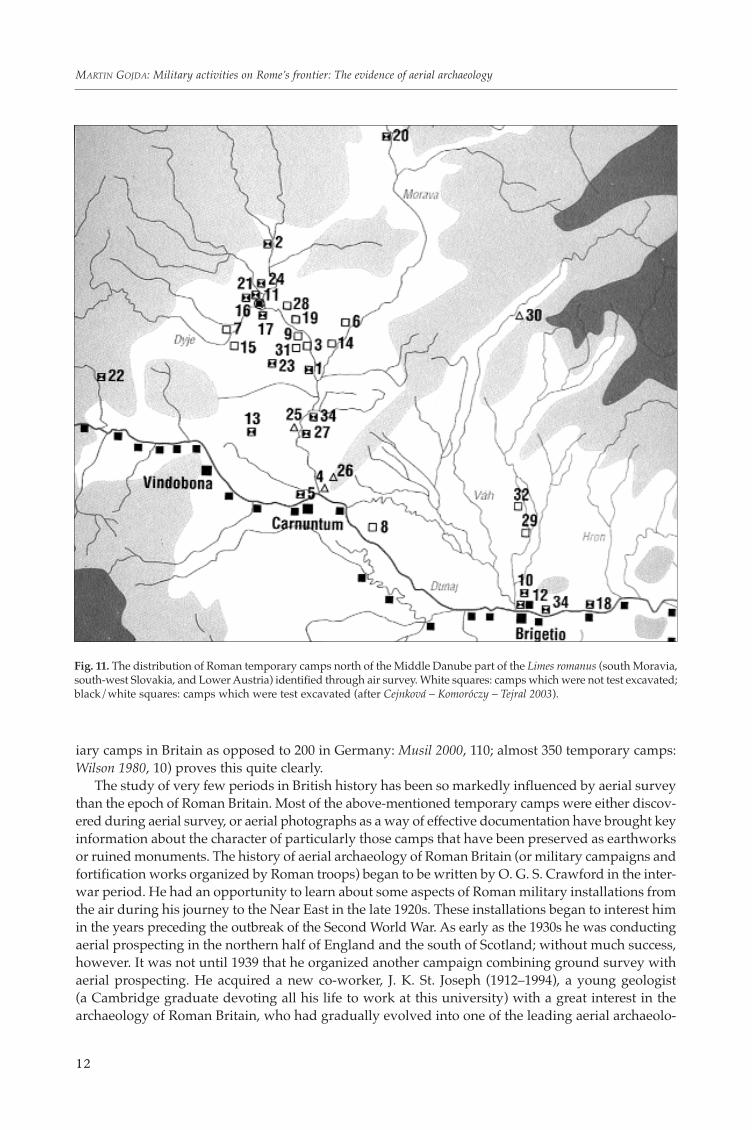
Fig. 11. The distribution of Roman temporary camps north of the Middle Danube part of the Limes romanus (south Moravia,south-west Slovakia, and Lower Austria) identified through air survey. White squares: camps which were not test excavated;black/white squares: camps which were test excavated (after Cejnková – Komoróczy – Tejral 2003).
gists in the history of the field. During the campaign, they discovered several unknown Roman forti-fications and reached the conclusion that southern Scotland, a territory in which the Romans had beencarrying out aggression beyond the frontier of the province of Britannia (having shifted it furthernorth for a short period of time), was hiding great survey potential in the area of identifying Romanmilitary installations (Deuel 1979, 78–82).
It was the co-operation with Crawford on this project which made St. Joseph realizes that theinvolvement of aerial archaeology could significantly enhance the knowledge of Roman Britain andits monuments of both civilian and, above, all military character. Immediately after the war, therefore,he embarked on extensive aerial surveys and as early as 1945 he managed to identify more militaryinstallations in northern Britain than had been found in the previous two centuries. Completely newknowledge was gained by St Josephs’s discoveries in the late 1940s regarding attempts at militaryannexation of a territory in the south-west of Scotland to the British province. At that time, severaldozen unknown temporary camps were discovered in the counties of Perthshire and Kirkcudbright-shire. One of the most important discoveries was made in 1949 when dry weather, or more preciselycropmarks, helped uncover the ground plan and inner arrangement of a legionary fortress in Inchtut-hil (Pitts – St. Joseph 1985).
Besides Scotland, K. St. Joseph paid great attention to the survey and aerial photo-documentationof military installations in Wales. In this part of Britain, the Romans had also left a large number ofboth completely buried and ruined structures (camps, fortresses, temporary camps, training grounds,etc.). One of the most remarkable and preserved compounds is Tomen-y-Mur, whose aerial photo-graphs from the late 1950s/early 1960s brought information about the overall composition of its in-dividual parts (a small amphitheatre, parade ground, bath house, barrows) and their interconnectionby a network of pathways and smaller camps in the surroundings. Tomen-y-Mur probably dates backto the initial period of Roman aggression in the north of Britain led by G. I. Agricola in the seventhdecade AD. It belongs among the most extensive Roman military complexes in the whole of Britain.
13
Vladimír Salač – Jan Bemmann (Hrsg.): Mitteleuropa zur Zeit Marbods. Praha – Bonn.
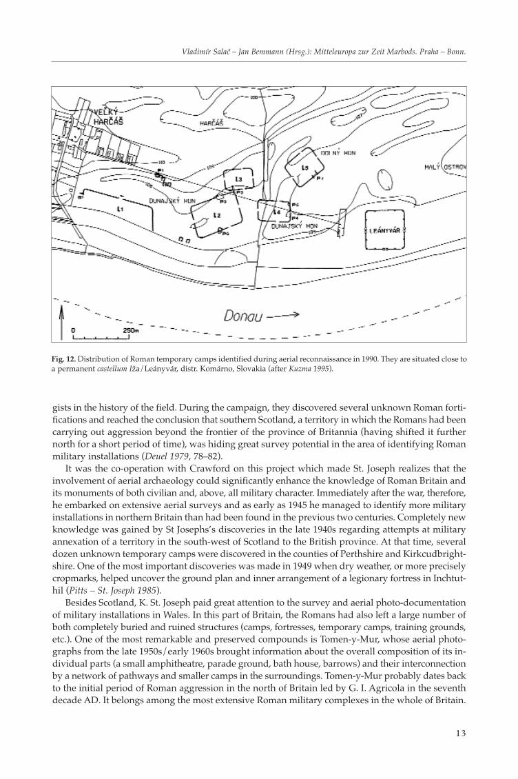
Fig. 12. Distribution of Roman temporary camps identified during aerial reconnaissance in 1990. They are situated close toa permanent castellum Iža/Leányvár, distr. Komárno, Slovakia (after Kuzma 1995).
During the reign of Emperor Hadrian, the original wooden camp buildings were replaced with stonestructures (St. Joseph 1961).
Thanks to K. St. Joseph’s continual aerial surveys, the directions of the movement of Roman troopsin Britain were successfully identified, often in great detail. By putting the newly identified Romancamps and communications on a map it was finally possible to reconstruct the extent of militarycampaigns northwards and westwards, to estimate with relative precision the size of the invadingtroops and thus confront the evidence of aerial photographs and archaeological research into thesecampaigns with the records thereof left by Roman authors in their works.
K. St. Joseph extensively and regularly published the results of his research in the 1950s–1970s,namely in a long series of contributions to the magazines The Journal of Roman Studies and Antiquity.The largest collection of his photographs was presented in a comprehensive monograph on RomanBritain (Frere – St. Joseph 1983). It appeared in the Cambridge Air Surveys edition, published until the1990s by the Cambridge University Press and featuring works on individual historical periods ofGreat Britain in the light of aerial survey (e.g. the monograph on medieval landscape, whose co-authorwas M. Beresford, was published twice – in 1958 and 1979). They were based on aerial photographsfrom the archive of the Cambridge University Committee for Aerial Photographs (today’s Unit forLandscape Modelling), which St. Joseph (later also his assistant and follower D. Wilson) presided andsupplied with his photographs from 1948 to the early 1980s.
14
MARTIN GOJDA: Military activities on Rome’s frontier: The evidence of aerial archaeology
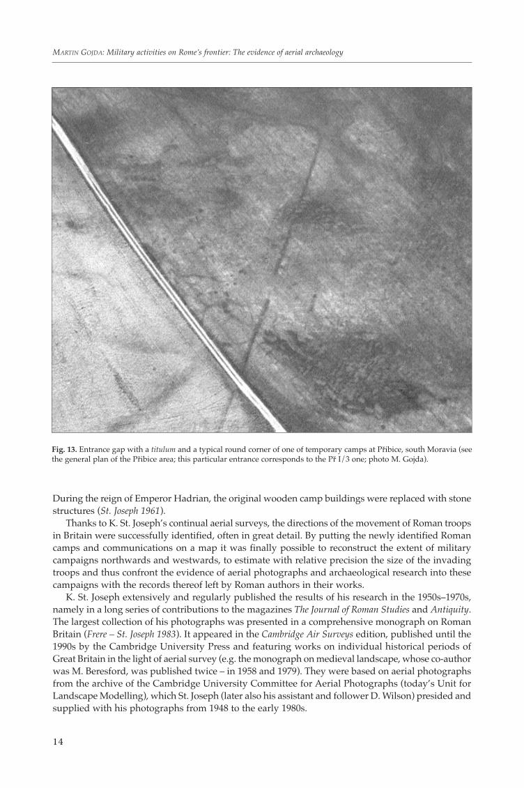
Fig. 13. Entrance gap with a titulum and a typical round corner of one of temporary camps at Přibice, south Moravia (seethe general plan of the Přibice area; this particular entrance corresponds to the Př I/3 one; photo M. Gojda).
Aerial prospecting and photographic documentation of military installations from the period ofRoman rule continue to the present, although not in the form of independent projects. They are car-ried out by the individual aerial survey departments in both England (as part of English Heritage),Scotland and Wales (part of Royal Commissions on the Historical Monuments) within their own
15
Vladimír Salač – Jan Bemmann (Hrsg.): Mitteleuropa zur Zeit Marbods. Praha – Bonn.
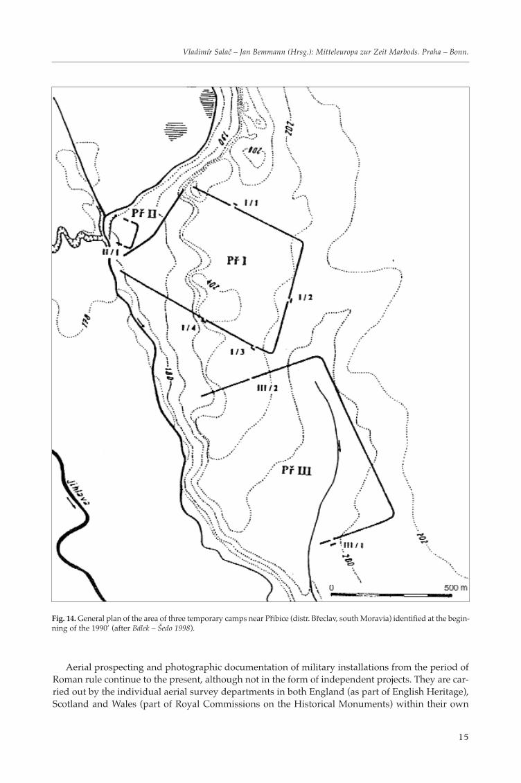
Fig. 14. General plan of the area of three temporary camps near Přibice (distr. Břeclav, south Moravia) identified at the begin-ning of the 1990’ (after Bálek – Šedo 1998).
programmes, now mostly aimed at the analysis and interpretation of vertical photographs and map-ping of archaeological monuments identified therein (the so-called National Mapping Programmein England). In any case, aerial photographs of military areas and structures remain a frequent illus-tration tool of publications on the history and archaeology of the Roman period. Undoubtedly, it wasalso aerial photographs, documenting in detail the complex landscape on the northernmost frontier ofthe Roman Empire, whose evidence led to the decision to include Hadrian’s Wall on the list of worldcultural heritage UNESCO in 1987 (the continual co-operation among specialists from the individualcountries of the Roman limes has lasted since 1949 when the Congress of Roman Frontier Studies, heldevery three years since then, took place for the first time; one of the key objectives of this cooperationis to achieve the inclusion of other stretches of Limes romanus on the above-mentioned list of worldcultural heritage; Breeze – Jilek – Thiel 2005).
4. EVIDENCE OF MILITARY CAMPAIGNS IN BARBARICUM ON THE TERRITORY OF THECZECH AND SLOVAK REPUBLICS AS PROVIDED BY AERIAL ARCHAEOLOGICAL SURVEY
Similar to Great Britain of the early post-war period, aerial survey connected with localizing monu-ments of military activities on the Roman frontier brought crucial knowledge regarding the territoryof former Czechoslovakia in the early 1990s. After the decline of the communist regime, some archae-
16
MARTIN GOJDA: Military activities on Rome’s frontier: The evidence of aerial archaeology
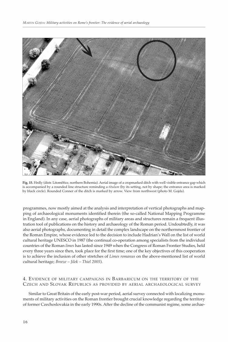
Fig. 15. Hrdly (distr. Litoměřice, northern Bohemia). Aerial image of a cropmarked ditch with well visible entrance gap whichis accompanied by a rounded line structure reminding a titulum (by its setting, not by shape; the entrance area is markedby black circle). Rounded Conner of the ditch is marked by arrow. View from northwest (photo M. Gojda).
ologists began to initiate the active inclusion of aerial archaeology methods in archaeological field-work. Although some activities had been undertaken in the area by Czech and Moravian specialistsin the previous decade, the legislation of the period did not enable this manner of information searchto be developed effectively (Gojda 1997; 2004, 64–70).
With the knowledge of the possibilities afforded by the view of the landscape from above, and underthe impression of results yielded by aerial archaeology above all in post-war England and later alsoin Austria, preparations were made in former Czechoslovakia immediately after the onset of democ-racy for the systematic aerial survey of the area north of the Danube frontier. The forefield of theRoman provinces of Noricum and Pannonia above the line of important Roman frontier camps ofVindobona, Carnuntum and Brigetio (the territory of the Barbarian tribes of Markomans and Kvads)is an area which, according to the knowledge of the period based on the evidence of written andarchaeological sources, was supposed to function as the departure area of Roman contingents dur-ing campaigns in the heart of Barbaricum. Of the archaeological evidence regarding the presence ofmonuments of allegedly Roman origin in south Moravia and south-west Slovakia, let us name e.g. thesites of Mušov-Burgstall, Cífer-Pác, Iža, Milanovce, and Stupava. Although earlier on, the structuresunearthed at these sites were regarded as evidence of Roman military activities (mainly from theperiod of the so-called Markoman Wars), they were later reinterpreted as being of civilian (repre-sentative and/or farm buildings?) character (e.g. Kolník 1995).
The only two sites of military character that could safely be proclaimed as being of Roman originon the Czechoslovac territory (i.e. the territory of former Barbaricum) known until the 1990s includedthe moated and walled area on the elevated location of Burgstall near Mušov and the stone (formerly
17
Vladimír Salač – Jan Bemmann (Hrsg.): Mitteleuropa zur Zeit Marbods. Praha – Bonn.
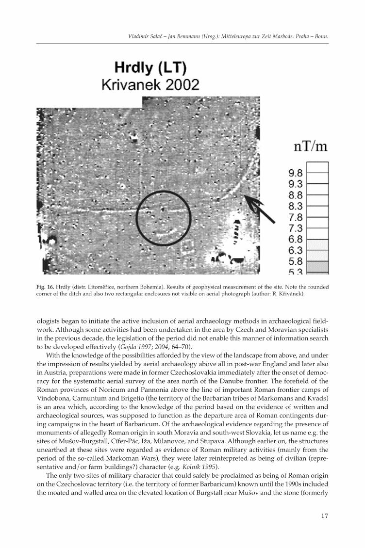
Fig. 16. Hrdly (distr. Litoměřice, northern Bohemia). Results of geophysical measurement of the site. Note the roundedcorner of the ditch and also two rectangular enclosures not visible on aerial photograph (author: R. Křivánek).
wooden) camp at Iža, situated on the northern bank of the Danube directly opposite the importantlegionary camp Brigetio. After aerial prospecting had discovered several temporary camps in LowerAustria (e.g. Bernardsthal, Kollnbrunn, Plank am Kamp), there arose a supposition that similar campswould in all likelihood be situated on the territory of south Moravia and Slovakia as well. After theinitial non-systematic attempts, continual aerial survey was finally launched in the early 1990s, result-ing in the discoveries of about 35 temporary camps (in some of these, their original function cannotbe unambiguously stated as they have been preserved in a very fragmented state). Of this number,12 safely interpreted objects are in Slovakia (Rajtár 1992; 1997; Kuzma 1995; Hanzelyová – Kuzma – Rajtár1996, 200–205; Kuzma – Tirpák 2003, 32–33), about 15 in Moravia. The others are uncertain, especiallyas regards the complex situation of eight ditches (preserved only in relatively short stretches) from thelocation of Mušov-Neurissen (Bálek – Droberjar – Šedo 1994; Bálek – Šedo 1998; Kovárník 1996, 182–189;1997; Šedo 1999). Most objects were identified in the years 1990–1996, only a few discoveries wereadded later (among others, a temporary camp was discovered near Olomouc; this was discoveredduring field survey, not by means of aerial prospection; it is the northernmost Moravian object ofthis kind). The most significant sites include especially those where greater accumulation of camps(or of ditches indicating either a camp or another fortified feature) was established in a single place:Moravia: Mušov (“Burgstall” I–II, “Neurissen” I–VIII, “Na pískách” I–IV), Pasohlávky (I–IV), PřibiceI–III, Ivaň (I–II); Slovakia: Iža 1–5, Radvaň n. Dunajom 1–2, Mužla 1–2, Závod 1–2.
As evidenced by aerial photographs, the size and shape of these features are relatively varied (thesummary of the present knowledge of temporary camps e.g. Musil 2000). Their area ranges betweenone and fifty hectares. Within this wide range, it is possible to single out groups of camps displayingthe size of about 40–50 ha (Radvaň n. Dunajom, Charvátská Nová Ves, Přibice III, Mušov “Na pís-kách” I) and about 20–30 ha (e.g. Přibice I, Mušov, “Na pískách” III). The hitherto largest temporarycamp discovered during aerial survey is the site Radvaň n. Dunajom (the dimensions of the campestablished by means of combining information from aerial photographs and magnetometric meas-uring: 830 x 600m, the total area of the camp may have been roughly 50 ha). Its size could suggest thatit accommodated a whole invasion troop before their march into the heart of the Germanic territory(Hanzelyová – Kuzma – Rajtár 1996, 205). As regards the shape of these camps, they usually havea regular rectangular ground plan (square, rectangle) with characteristic rounded corners and accessinterruptions which are regularly reinforced by forward ditches (so-called titulum/tutulus). They alsotend to have the form of an irregular trapezoid and their ditches sometimes appear illogically angular.
In the early 1990s, aerial survey was carried out and funded due to the fact that it took place at theframework of an international project presided by the University of Vienna (Moravia) and Römisch-Germanische Kommission (Slovakia). It was also included in the grant project of the ArchaeologicalInstitute of Brno, which was monitoring the relations between the Romans and the Germans in theriver Dyje basin. Owing to the involvement in the projects it was possible to carry out surveying andfieldwork in a series of the newly identified camps. This mostly concerned sections through the ditchesand limited digging in the space of the access interruptions (gates – e.g. Ivaň I, Přibice II, Mušov“Neurissen” I). In Slovakia, almost all of the newly discovered camps were also researched by meansof geophysics (proton and caesium magnetometer), the results of which, however, were only positivein the camps of Mužla and Radvaň. The only camp to be completely measured in this manner wasZávod (Kuzma – Tirpák 2003, 32–33). A significant contribution of geophysical research was also madein the case of the object at Radvaň; in the line of a ditch preserved in a very fragmented manner twoentrances complete with characteristic forward ditches were discovered, having thus confirmed thatthe object was indeed a Roman temporary camp.
A very important discovery made during aerial survey of the Barbarian territory over the CentralDanube stretch of Rome’s frontier is the ground plan of a complex building with an apse revealed bycropmarks not far from the edge of a terrace in the location of Mušov “Neurissen”. Although on thebasis of the occurrence of a few small immoveable finds – especially two buckles – the authors of theresearch dated this building of the dimensions 44 x 20 m, together with some other features (ditches),to the era of Emperor Augustus and linked it with the campaign of the later Emperor Tiberius against
18
MARTIN GOJDA: Military activities on Rome’s frontier: The evidence of aerial archaeology
the Markomans in AD 6 (Bálek – Šedo 1998, 159, 173, 181; Šedo 1999), this interpretation tends to berejected at present (Komoróczy 2006). Practically all the temporary camps are dated today to the periodof the Markoman Wars, led by the Roman Empire in 166–180 AD by Emperor Marcus Aurelius andterminated during the reign of his successor Commodus.
The contribution made by aerial survey to the archaeology of the Roman period in Moravia andSlovakia consists in several areas. First, it fundamentally enriched the previous source base of thisperiod with hitherto unevidenced types of military installations connected with Roman militaryactions against the Germanic and Sarmat tribes (the so-called temporary or marching camps). Next,it changed our ideas of the overall context of the only two Roman fortified structures recorded untilrecently (Burgstall in Moravian Mušov and Iža in Slovakia), since it was aerial prospecting thatrevealed an extensive cluster of these temporary bases in their near and more distant vicinity, thusproving the strategic significance of the territory on which they are situated. Similar to Britain, inthe case of Moravian and Slovak temporary camps we nowadays have a much clearer idea of thedirections and communications by means of which Roman troops had been embarking into the heartof Barbaricum during their campaigns.
Although after a series of peripetia, the campaign against the Markomans in AD 6 is now assessedwith much reserve, mostly assuming that it was never practically started (Salač 2006; Kehne 2006), itcannot be entirely ruled out that Roman troops also reached Bohemia (western part of the CzechRepublic) during their aggression beyond the Danube frontier. Aerial survey, having been conductedhere for 15 years, recorded several features somewhat resembling temporary camps. However, prac-tically all of them lack at least two characteristic features enabling these structures to be regarded ascamps left behind by Roman expedition troops. The only possible exception is a feature situated nearthe village of Hrdly not far from the confluence of the Elbe with the Ohře close to the district town ofLitoměřice. It is a ditch line of about the same width as is known from several Moravian and Slovakianditches (1.5–2 m), interrupted in one place. At the distance of 20 metres from this interruption, the lineof a forward ditch is visible whose rounded shape, however, is untypical of a potential titulum. As theoutput of the geophysical measuring of this object indicates, the moat forms a characteristic roundedcorner on the right-hand side. Clearly visible are also two roughly square-ditched enclosures of sidelength 8–10 m, situated in the near vicinity south-east of the forward ditch. They are probably objectsof burial character (perimeter ditches of square barrows?).
Any conclusions regarding the origin (age and function) of the ditch structure from Hrdly is pre-mature without further fieldwork, including excavation.
5. CONCLUSION
Using the example of some parts of Rome’s frontier (Limes romanus), the contribution has summa-rized the results by means of which aerial archaeological survey joined with photo documentationfrom above has enhanced the knowledge of military activities on this frontier and beyond. It haspointed out the uniqueness of this method in the data collection process, as Roman military instal-lations tended to reach vast dimensions, making the recording of their ground plans, landscape andother contexts practically impossible in any other manner. Without much exaggeration it can be claimedthat aerial archaeology has played a decisive role in the knowledge and understanding of the systemof Rome’s fortified frontier, in tracing the directions taken by military contingents during the conquestof enemy territories and even in the estimation of the numbers of soldiers involved. At present, con-siderable opportunities for the study of this problem are offered by vertical aerial photographs (more-over, easily accessible on the Internet) or satellite images. Unprecedented potential is also offered bythe sophisticated methods such as aerial laser scanning (so-called Lidar), by means of which it is pos-sible to perfectly map the earth’s surface including indiscernible relief forms of disappeared objectsleft in the landscape by the conquerors from the period of the Roman Empire. It can be expected thatremote sensing will continue to enrich the archaeology of the Roman period to a considerable degree.
19
Vladimír Salač – Jan Bemmann (Hrsg.): Mitteleuropa zur Zeit Marbods. Praha – Bonn.
BIBLIOGRAPHY
Bálek, M. – Šedo, O. 1998: Příspěvek k poznání krátkodobých táborů římské armády na Moravě. Památky archeologické 89,159–192.
Bálek, M. – Droberjar, E. – Šedo, O. 1994: Die römischen Feldlager in Mähren (1991–1992). Památky archeologické 85/2, 59–74.Baradez, J. 1949: Fossatum Africe. Vue aérienne de l‘organisation romaine dans le Sud-Algérien. Paris.Beazeley, G. A. 1919: Air Photography in Archaeology. Geographical Journal 53, 330–335.— 1920: Surveys in Mesopotamia during the war. Geographical Journal 55, 109–127.Breeze, D. J. – Jilek, S. – Thiel, A. 2005: Frontiers of the Roman Empire. Edinburgh – Esslingen – Wien.Cejnková, D. – Komoróczy, B. – Tejral, J. 2003: Římané a Germáni, nepřátelé, rivalové, sousedé. Brno.Crawford, O. G. S 1924: Air Survey and Archaeology. Ordnance Survey Professional Papers. New Series No. 7. Southampton.— 1954: A century of Air Photographs. Antiquity 28, 206–210.Crawford, O. G. S. – Keiller, A. 1928: Wessex from the Air. Oxford.Deuel, L. 1979: Objevy z ptačí perspektivy. Praha.Frere, S. S. – St. Joseph, J. K. S. 1983: Roman Britain from the Air. Cambridge.Gojda, M. 1997: Letecká archeologie v Čechách – Aerial Archaeology in Bohemia. Prague.— 2004: Letecká archeologie a dálkový průzkum. In: Kuna, M. et al.: Nedestruktivní archeologie, Praha, 49–115.Gregory, S. – Kennedy, D. 1985: Sir Aurel Stein‘s Report “Limes Report“. BAR International Series 272. Oxford.Hanzelyová, E. – Kuzma, I. – Rajtar, J. 1996: Letecká prospekci v archeológii na Slovensku. Archeologické rozhledy, 194–212.Jones, B. 2000: Aerial Archaeology around the Mediterranean. In: Pasquinucci, M. – Trément, F. (eds.): Non-Destructive
Techniques Applied to Landscape Archaeology, Oxford, 49–60.Kehne, P. 2006: Vojenské podmanění Marobudovy říše plánované na rok 6 po Kr. Augustem a Tiberiem: válka bez boje.
Archeologické rozhledy 58, 447–461.Kennedy, D. (ed) 1989: Into the Sun. Essays in Air Photography in Archaeology in Honour of Derrick Riley. Sheffield.Kennedy, D – Bewley, R. 2004: Ancient Jordan from the Air. London.Kennedy, D. – Riley, D. 1990: Romes‘s Desert Frontier from the Air. London.Kolník, T. 1995: Zum Problem der vielenartigen Bauten im mitteldanubischen Barbarikum. Balácai Közlemények 3, 359–368.Komoróczy, B. 2006: K otázce existence římského vojenského tábora na počátku 1. století po Kr. u Mušova (kat. úz. Pasohlávky,
jihomoravský kraj). In: Droberjar, E. – Lutovský, M. (eds.): Archeologie barbarů 2005, Praha, 155–205.Kovárník, J. 1996: Přínos letecké archeologie k poznání pravěku a rané doby dějinné na Moravě (1983–1995). Archeologické
rozhledy 48, 177–193.— 1997: Neue Entdeckungen römischer Feldlager nördlich von der Mitteldonau. In: Čižmářová, J. – Měchurová, Z. (eds.):
Peregrinatio Gothica – Jantarová stezka, Supplementum ad Acta Musei Moraviae Scientiae Sociales 82, Brno, 87–109.Kuzma, I. 1995: Luftbildarchäologie in der Slowakei. In: Aerial Archaeology in Eastern and Central Europe, Forschungen zur
Archäologie im Land Brandenburg 3, Potsdam, 251–258.Kuzma, I. – Tirpák, J. 2003: Niektoré výsledky leteckej a geofyzikálnej prospekcie v rokoch 1999–2002 v AÚ SAV Nitra. In:
Ve službách archeologie 4. Sborník k 75. narozeninám Vladimíra Nekudy, Brno, 30–37.Mouterde, R. – Poidebard, P. 1945: Le Limes de Chalcis. Organisation de la Steppe en Haute-Syrie Romaine. Paris.Musil, A. 1928: Palmyrena. New York.Musil, J. 2000: Dočasné římské tábory v literárních a archeologických pramenech. Studia Hercynia 4, 103–136.Nesbit, R. C. 2003: Eyes of the RAF. Stroud.Pitts, L. F. – St. Joseph, J. K. 1985: Inchtuthil. The Roman Legionary Fortress. Britannia Monograph Series 6. London.Poidebard, A. 1934: La Trace de Rome dans le Désert de Syrie. Paris.Rajtár, J. 1992: Das Holz-Erde-Lager aus der Zeit der Markomannenkriege in Iža. In: Probleme der relativen und absoluten
Chronologie ab Latènezeit bis zum Frühmittelalter, Kraków, 149–170.— 1997: Temporäre römische Militärlager in der Slowakei. In: Groenman-van Waateringe, W. et al. (eds.): Roman Frontier
Studies 1995. Proceedings of the 16th International Congress of Roman Frontier Studies, Oxford, 473–477.Riley, D. 1987: Air Photography and Archaeology. London.Salač, V. 2006: 2000 let od římského vojenského tažení proti Marobudovi. Naše nejstarší historické výročí a metodologické
problémy studia starší doby římské. Archeologické rozhledy 58, 462–485.Šedo, O. 1999: Přínos letecké prospekce a výzkumu v trati Neurissen v Mušově k poznání římského působení v jihomorav-
ském prostředí. Jižní Morava 35/38, 7–32.St. Joseph, J. K. S. 1961: Aerial Reconnaissance in Wales. Antiquity 35, 263–275.Stein, M. A. 1940: Surveys on the Roman Frontier in Iraq and Transjordan. Geographical Journal 95, 428–438.Wiegand, T. 1920: Sinai. Wissenschaftlichen Veröffentlichen des Deutsch-Türkischen Denkmalschutzkommandos. Berlin.Wilson, R. 1980: Roman Forts. London.
Autor, adresae-mail:
20
MARTIN GOJDA: Military activities on Rome’s frontier: The evidence of aerial archaeology