Embed Size (px)
Citation preview
urban planning | urban design | landscape architecture
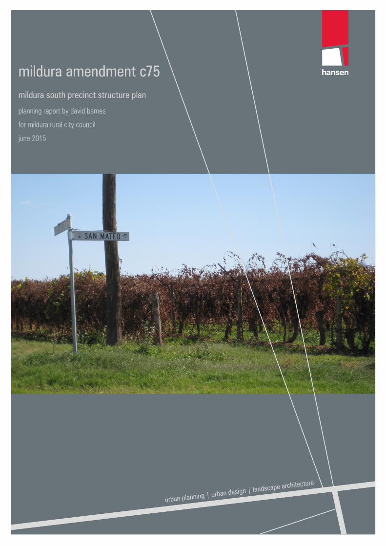
mildura amendment c75mildura south precinct structure plan
planning report by david barnes
for mildura rural city council
june 2015
mildura amendment c75 | hansen partnership
urban planning | urban design | landscape architecture
contents 1 introduction ......................................................................................................... 1
2 purpose of the amendment ................................................................................. 3
3 the mildura south structure plan and development plan ...................................... 4
3.1 background .................................................................................................................................................. 4 3.2 context .......................................................................................................................................................... 4 3.3 ................................................................................................................................ 5 3.4 directions contained in the plans .................................................................................................................. 5
4 response to panel’s questions ............................................................................. 6
4.1 why is the neighbourhood activity centre is where it is ................................................................................ 6 4.2 why is the primary school where it is ............................................................................................................ 7 4.3 why has council adopted a density of 15dph, should it be lower as per other regional towns ..................... 8 4.4 what is the area of open space provided in % terms ................................................................................... 9 4.5 why the choice of ugz for nac area .............................................................................................................. 10 4.6 why aren’t other farming zoned areas in the precinct proposed for rezoning at this time ........................ 10 4.7 where does the mildura south precinct sit in terms of the broader mildura housing strategy and the
supply and demand for housing in the mildura area ...................................................................................... 10 4.8 is there an intention to prepare a development contributions plan for mildura south ........................ 12 4.9 is there an intention to place a floor space limit on ‘shop’ in the s chedule to the commercial 1
zone (which applies under the ugz) ............................................................................................................... 12
5 submissions ........................................................................................................ 13
6 the need for a neighbourhood activity centre ....................................................... 15
7 the location of the neighbourhood activity centre on south corner of sixteenth street and ontario avenue .................................................................... 16
7.1 inconsistency with ministerial direction 12.................................................................................................... 16 7.2 previous exhibition of an alternative location ............................................................................................... 17 7.3 a location on Lake Hawthorn ........................................................................................................................ 17 7.4 a more southerly location ............................................................................................................................. 18 7.5 the slope and elevation of the land .............................................................................................................. 18
8 the location of the neighbourhood activity centre opposite existing houses in sixteenth street ................................................................................................ 19
9 the layout of the nac ............................................................................................ 22
10 use of the urban growth zone on the nac site ...................................................... 23
11 need for a precinct structure plan ........................................................................ 24
12 location of open space between riverside avenue and ontario avenue: ............... 25
13 native vegetation at the corner of sixteenth street and riverside avenue ............. 26
14 rezoning land near the corner of riverside avenue and seventeenth street ......... 27
15 land acquisition ................................................................................................... 28
16 conclusion ........................................................................................................... 29
mildura amendment c75 | hansen partnership
urban planning | urban design | landscape architecture
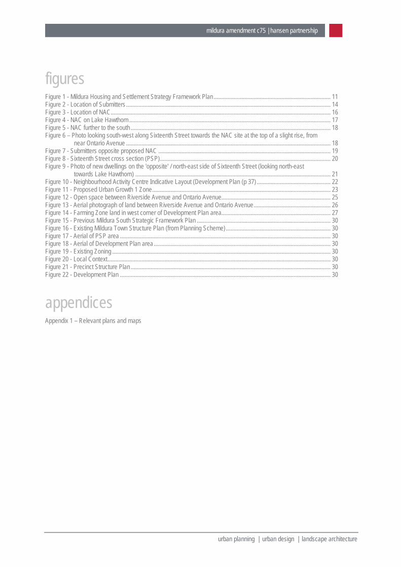
figures Figure 1 - Mildura Housing and Settlement Strategy Framework Plan ............................................................................ 11 Figure 2 - Location of Submitters ..................................................................................................................................... 14 Figure 3 - Location of NAC ............................................................................................................................................... 16 Figure 4 - NAC on Lake Hawthorn ................................................................................................................................... 17 Figure 5 - NAC further to the south .................................................................................................................................. 18 Figure 6 – Photo looking south-west along Sixteenth Street towards the NAC site at the top of a slight rise, from
near Ontario Avenue ..................................................................................................................................... 18 Figure 7 - Submitters opposite proposed NAC ................................................................................................................ 19 Figure 8 - Sixteenth Street cross section (PSP) ............................................................................................................... 20 Figure 9 - Photo of new dwellings on the 'opposite' / north-east side of Sixteenth Street (looking north-east
towards Lake Hawthorn) ............................................................................................................................... 21 Figure 10 - Neighbourhood Activity Centre Indicative Layout (Development Plan (p 37) ................................................ 22 Figure 11 - Proposed Urban Growth 1 Zone .................................................................................................................... 23 Figure 12 - Open space between Riverside Avenue and Ontario Avenue ....................................................................... 25 Figure 13 - Aerial photograph of land between Riverside Avenue and Ontario Avenue .................................................. 26 Figure 14 - Farming Zone land in west corner of Development Plan area ....................................................................... 27 Figure 15 - Previous Mildura South Strategic Framework Plan ....................................................................................... 30 Figure 16 - Existing Mildura Town Structure Plan (from Planning Scheme) .................................................................... 30 Figure 17 - Aerial of PSP area ......................................................................................................................................... 30 Figure 18 - Aerial of Development Plan area ................................................................................................................... 30 Figure 19 - Existing Zoning .............................................................................................................................................. 30 Figure 20 - Local Context ................................................................................................................................................. 30 Figure 21 - Precinct Structure Plan .................................................................................................................................. 30
Figure 22 - Development Plan ......................................................................................................................................... 30
appendices Appendix 1 – Relevant plans and maps
mildura amendment c75 | hansen partnership 1
urban planning | urban design | landscape architecture
1 introduction 1. My name is David Barnes. I am the Managing Director of Hansen Partnership Pty Ltd, Urban Planning,
Urban Design, Landscape Architecture, Level 4, 136 Exhibition Street, Melbourne.
2. I hold the following qualifications: Bachelor of Town and Regional Planning (Hons), University of Melbourne, 1980. Master of Business Administration, Royal Melbourne Institute of Technology, 1993.
3. I have practiced as a town planner for over 30 years, working in the public as well as the private sectors. I have also worked overseas in Vietnam on a variety of statutory and strategic planning projects.
4. I am both a statutory and a strategic planner. My statutory planning experience covers many aspects of the planning approvals process on a range of projects including residential, industrial, retail, mixed use and rural developments. I regularly appear before VCAT and Planning Panels Victoria. I have been involved in a broad range of strategic planning projects including the preparation of rural strategies, industrial land use strategies, residential development strategies, integrated municipal strategies, township strategies, town centre strategies, structure plans and urban design frameworks for activity centres and transit cities.
5. I have been engaged by the Mildura Rural City Council to: Review the planning merits of Amendment C75, in light of work undertaken by Hansen Partnership in
preparing the Mildura South Structure Plan and other related documents, which provide the strategic justification for much of the amendment.
Review and respond to submissions made to the amendment.
6. I draw to the Panel’s attention that whilst my office prepared the above documents, I was not directly involved in their preparation at the time. Jane Keddie, an Associate with Hansen Partnership, was the key person involved in preparing those reports.
7. Key documents I have reviewed in preparing this statement include the following: Mildura South Strategic Framework Plan (MSSFP) that was developed by David Lock and Associates
in 2007. Mildura Planning Scheme. Amendment C75 documentation – as exhibited. All submissions made to the amendment. Mildura South Urban Design Plan - Context and Framework Plan Review, March 2011 Mildura South Urban Design Plan - Precinct Structure Plan, October 2014 Mildura South (Sixteenth & Deakin West) Development Plan, October 2014 Mildura South Recreation Assessment, November 2014
8. A summary of my opinions follows: Amendment C89 presents a generally accurate translation of the Mildura South Precinct Structure Plan
project into the planning scheme. The Mildura South Precinct Structure Plan and Development Plan are important documents in terms of
facilitating the development of the next major residential growth front in Mildura.
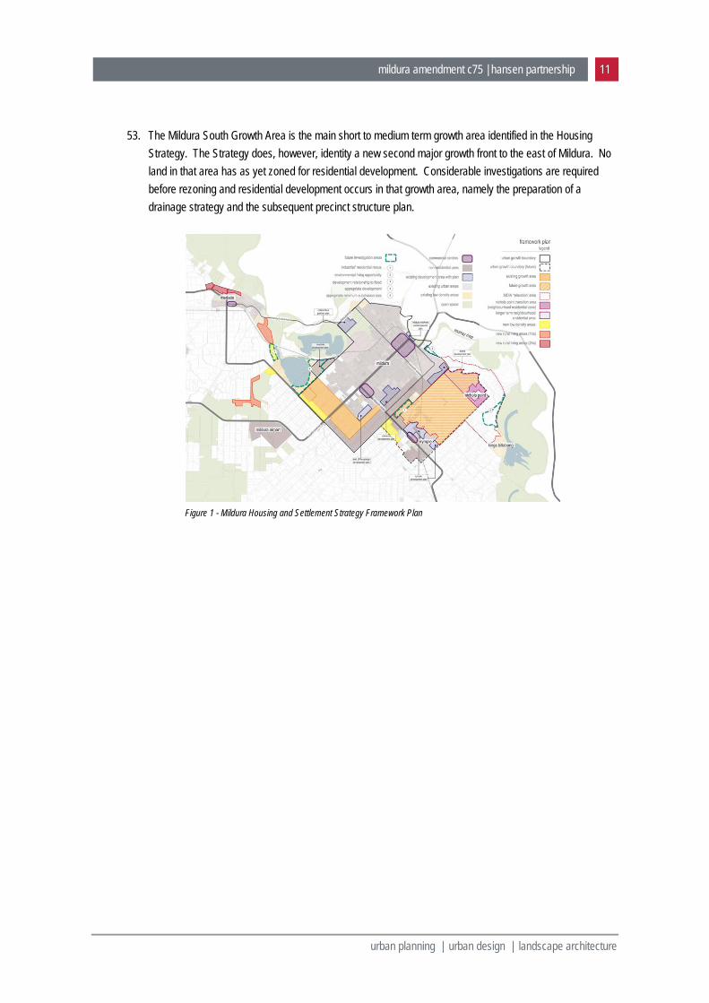
mildura amendment c75 | hansen partnership 2
urban planning | urban design | landscape architecture
The proposed NAC is a much needed and important focal point to establish in this major residential development area. It will provide not only retail, but importantly community services and facilities in the Mildura South area.
The location of the NAC on the south corner of Sixteenth Street and Ontario Avenue is the most appropriate location for the Centre.
Location of the NAC on Sixteenth Street is critical to its success and accessibility. No other appropriate location is available on Sixteenth Street, that would avoid the Centre being located ‘across the road’ from existing or future residential development.
There is a need for both a PSP and a Development Plan, given that the PSP applies to a much larger growth area, on both sides of Deakin Avenue, whilst the Development Plan only applies to the first stage of development to the north-west of Deakin Avenue.
The rezoning of the proposed NAC to an Urban Growth Zone is an appropriate use of that zone. The proposed “major open space” identified between Riverside Avenue and Ontario Avenue should not
be moved. In the amendment documentation, the name “Department of Environment and Primary Industries”,
should be replaced with the name “Department of Environment Land Water and Planning”. Council should hold discussions with the Department of Land Water and Planning regarding the
purported ‘environmental significance’ of land between Ontario Avenue and Riverside Avenue. Council should hold further discussions with land owners affected by proposed drainage basins and
public open space (Submissions 7 and 9).
9. This statement has been prepared in accordance with Planning Panels Victoria Guideline No. 1 - Expert Evidence.
10. I have made all the inquiries that I believe are desirable and appropriate and no matters of significance which I regard as relevant have to my knowledge been withheld from the Panel.
mildura amendment c75 | hansen partnership 3
urban planning | urban design | landscape architecture
2 purpose of the amendment 11. As set out in the explanatory statement for the amendment, the reason for the amendment is follows:
The amendment is required to implement the strategic intent of the Mildura South Precinct Structure Plan, Mildura South Recreation Assessment and the Mildura South (Sixteenth and Deakin West) Development Plan which set out Council’s plan for managing residential development in the next major growth area of the settlement.
The amendment:
1. Amends the Municipal Strategic Statement by updating Clause 21.04 (Settlement and Housing), Clause 21.05 (Environment) and Clause 21.10 (Local Areas) and includes the Mildura South (Sixteenth and Deakin West) Development Plan and Mildura South Recreation Assessment 2014 as reference documents.
2. Amends Clause 81.01 to include the Mildura South Precinct Structure Plan 2014 as an incorporated document.
3. Inserts the Urban Growth Zone and associated Schedule 1 into the Mildura Planning Scheme.
4. Rezones land at 634-670 Ontario Avenue Mildura South from General Residential Zone to Urban Growth Zone (Schedule 1).
5. Rezones land at 127-135 Sixteenth Street Mildura South from Public Utility Zone (Service and Utility) to the Urban Growth Zone (Schedule 1).
6. Rezones three parcels of Council owned land at 624-682 Deakin Avenue Mildura to the Public Park and Recreation Zone and applies the Salinity Management Overlay to this land.
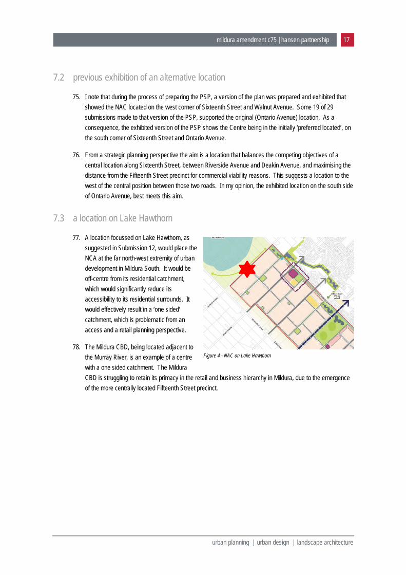
7. Rezones three parcels of Council owned land at 624-682 Deakin Avenue Mildura South from Farming Zone to the Public Park and Recreation Zone and applies the Salinity Management Overlay to this land.
mildura amendment c75 | hansen partnership 4
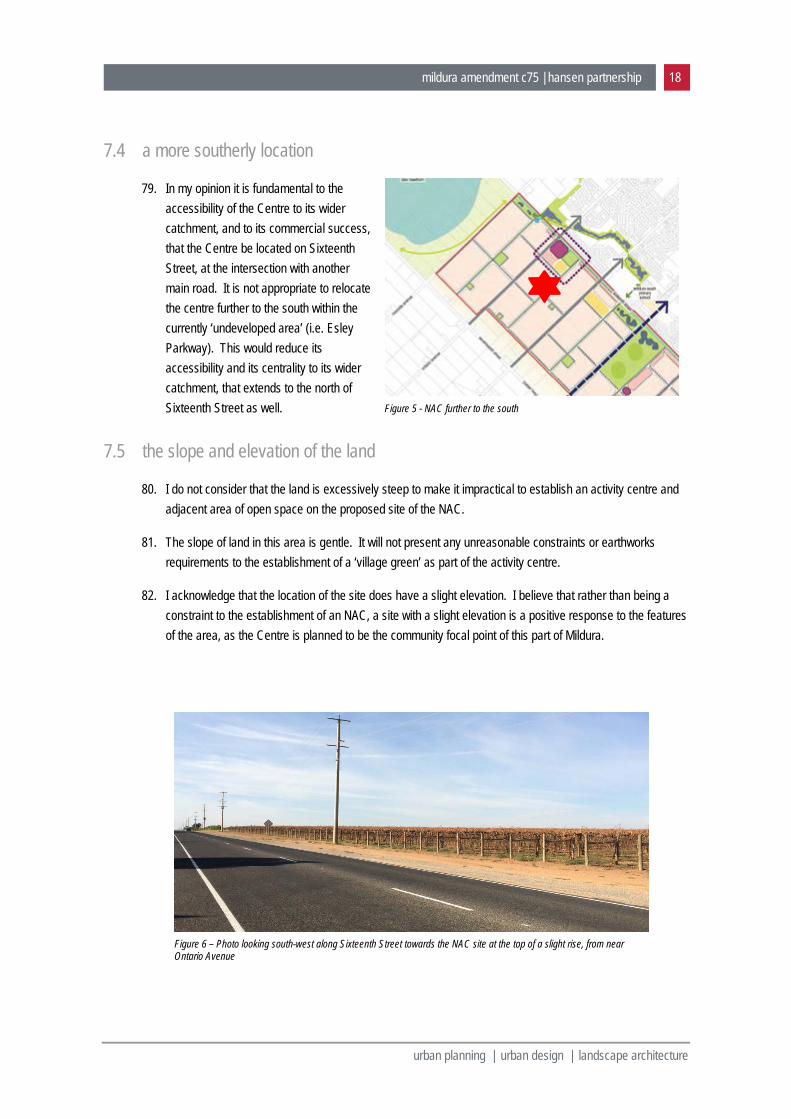
urban planning | urban design | landscape architecture
3 the mildura south structure plan and development plan
3.1 background
12. Hansen Partnership was engaged by Mildura Rural City Council to prepare a Precinct Structure Plan (PSP) for the Mildura South Growth Area. The study area for the project had been identified for more than a decade as the area that would accommodate the next major stage of Mildura’s residential growth (See Figure 15 in Appendix 1). (Structure Plan report, p. 3)
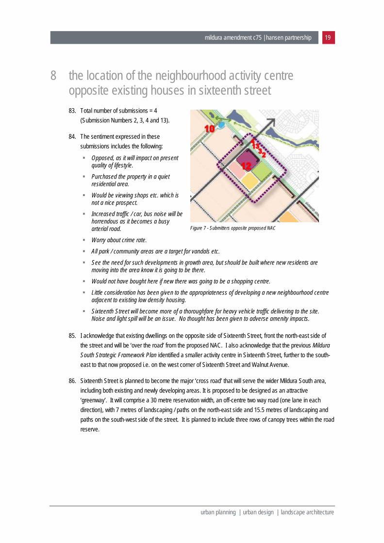
13. The PSP forms one component of a project referred to as the Mildura South Urban Design Plan. The Mildura South Urban Design Plan project comprises the following two parts: A Precinct Structure Plan for the entire study area; and A Development Plan for part of the study area already zoned for residential use and currently affected
by a Development Plan Overlay (DPO).
14. The Mildura South Urban Design Plan builds on the Mildura South Strategic Framework Plan (MSSFP) (See Figure 14 in Appendix 1) that was developed by David Lock and Associates in 2007.
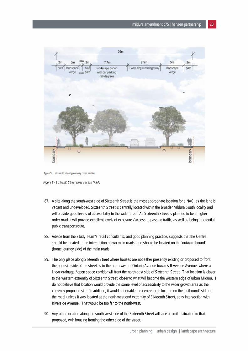
15. As background to the preparation of the Mildura South Urban Design Plan, a Context and Framework Plan Review (2011) was prepared by Hansen Partnership in collaboration with Aurecon (traffic and engineering), Hill PDA (economics), Capire (social infrastructure) and James Golsworthy (planning). That review comprised an assessment of the local context and existing conditions, and a policy and contextual review of the MSSFP, to determine if there had been any changes in the years since 2007 that would need to be considered in the development of the area. The intention of Urban Design Plan project was not to ‘rewrite’ the vision for Mildura South, but to build upon the existing knowledge base of the study area and to reinforce the guiding planning and urban design principles established in the initial framework plan.
16. The PSP was prepared in line with the Precinct Structure Planning Guidelines (2009), prepared by Melbourne’s former Growth Area Authority (now the Metropolitan Planning Authority).
3.2 context
17. The initial stages of the Mildura South growth area begin at Fifteenth Street. However, few facilities have been developed in that area, within limited open space and community facilities provided in the past. The Mildura South Primary School and the open space provided in conjunction with the Sixteenth Street drainage system, are notable exceptions in the area to the north-east of Sixteenth Street. (Development Plan report, p. 6)
18. Access to shopping, including food and discretionary shops, is generally provided by retail facilities in the Fifteenth Street retail and commercial spine, to the east. While there is a small commercial centre on Walnut Avenue, the majority of existing residents rely on Fifteenth Street to meet their needs.
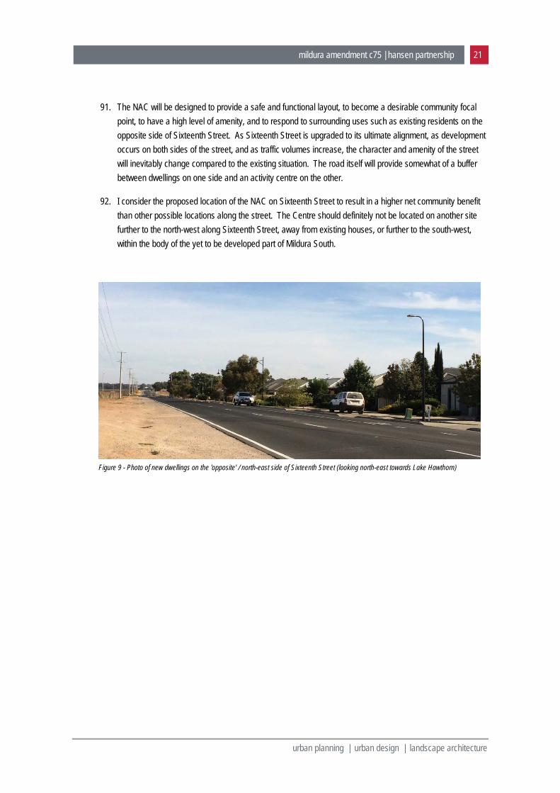
19. To the west the growth area abuts the Lake Hawthorn area, which together with Lake Ranfurly further to the north, form the western edge of Mildura. Both lakes are environmentally sensitive, ephemeral lakes that often dry out in summer.
mildura amendment c75 | hansen partnership 5
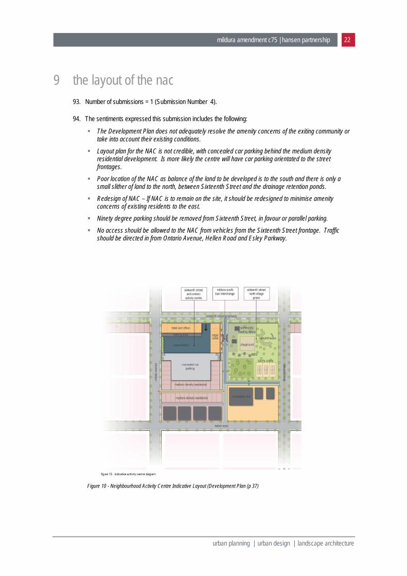
urban planning | urban design | landscape architecture
20. South of the growth area is the Calder Highway, which will form the long term boundary of urban Mildura, given the presence of Mildura Airport to the south.
3.3 land covered by the plans
21. The PSP affects and extensive area of land to the south-west of Mildura, spanning both sides of Deakin Avenue (see Figure 16) Only part of this land is zoned residential, with much remaining in a Farming Zone (see Figure 18)
22. The Development Plan only applies to land to the north-west of Deakin Avenue, which is already zoned General Residential (see Figures 17 and 18). That land has an area of approximately 180ha. The area is defined by Deakin Avenue, Sixteenth Street and Riverside Avenue. To the south, the Development Plan area broadly follows a topographical ridgeline, stopping short of Seventeenth Street (Calder Highway) and reflecting different catchment areas. Land within the Development Plan area has been considered as part of the broader Mildura South drainage plan area, which uses the Sixteenth Street drain, which also services the land between Fifteenth and Sixteenth Streets. (Development Plan report, p6)
3.4 directions contained in the plans
23. The key directions of the PSP and Development Plan are best summarised by reference to the following key plans from the PSP report (plans contained in Appendix 1). I intend to briefly explain the directions contained in these plans to the Panel, by way of a PowerPoint presentation on the day of the hearing, if this is of benefit to the Panel. Figure 14 - Previous Mildura South Strategy Framework Plan Figure 15 - Existing Mildura Town Structure Plan (from Planning Scheme) Figure 16 - Aerial of PSP area Figure 17 - Aerial of Development Plan area Figure 18 - Existing Zoning Figure 19 - Local Context Figure 20 - Precint Structure Plan Figure 21 - Development Plan
mildura amendment c75 | hansen partnership 6
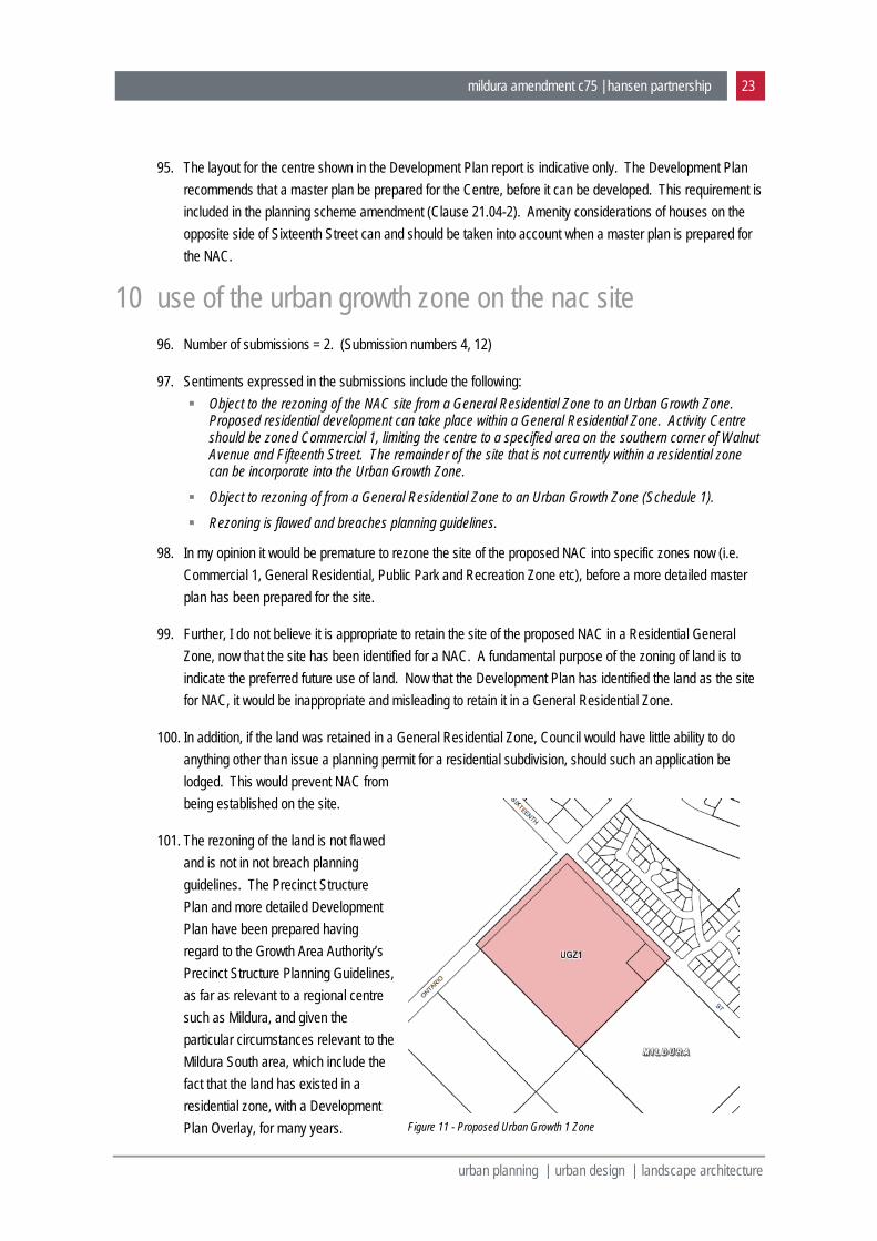
urban planning | urban design | landscape architecture
4 response to panel’s questions 24. Following the Directions Hearing, the Panel has requested that the following matters be addressed in
relation to Amendment C75: The reasons for the proposed location of the Neighbourhood Activity Centre. The reasoning for the proposed location of the primary school, given the proximity of Mildura South
primary school. Is the choice of 15 dwellings per ha appropriate for the Mildura market? Experience in other regional
cities is that slightly lower densities are more appropriate. The reasons for the choice of the UGZ for the Neighbourhood Activity Centre. Why aren’t other Farming Zone areas in the precinct proposed for rezoning at this time? Where does the Mildura South precinct sit in terms of the broader Mildura housing strategy and the
supply and demand for housing in the Mildura area? Is there an intention to prepare a Development Contributions Plan for Mildura South? Is there an intention to place a floor space limit on ‘shop’ in the Schedule to the Commercial 1
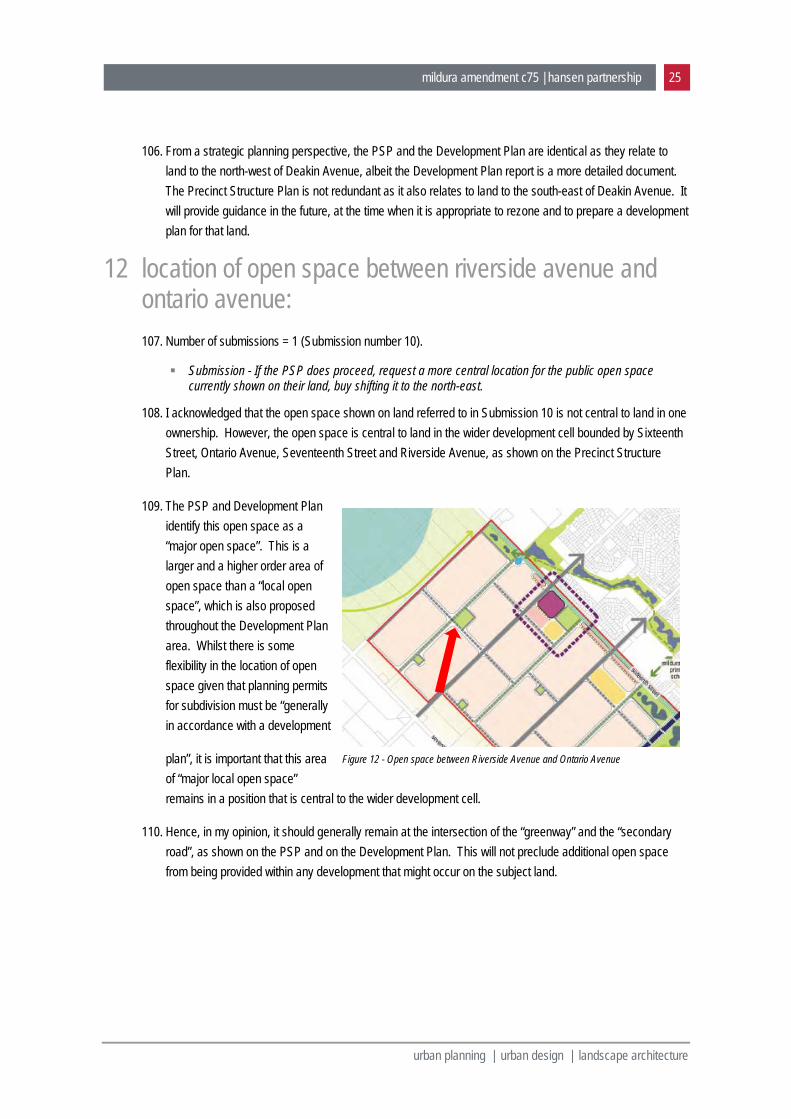
Zone (which applies under the UGZ)?
4.1 why is the neighbourhood activity centre is where it is
25. The proposed NAC site represents the optimal location for the focal point for the future Mildura South community. Essentially it is the 'best fit' location.
26. The importance of locating a NAC along Sixteenth Street was first identified in the Mildura South Strategic Framework Plan (2007).
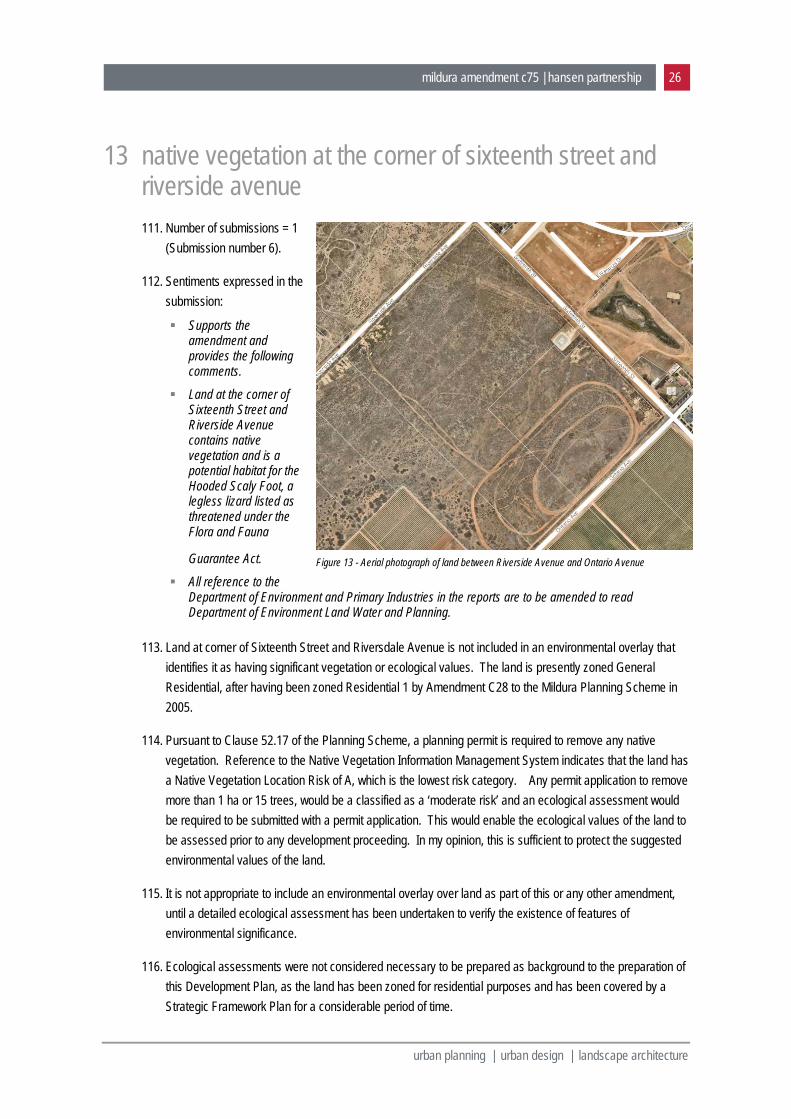
27. A location on Sixteenth Street also supports the use of the centre by existing Mildura South residents (i.e. to the north-west of Sixteenth Street, and assists in creating cohesion between the two communities.
28. Background reports prepared as part of the preparation of the Structure Plan identify that only one 'larger' centre is needed in the Mildura South area, with a meaningful retail component, and that such a centre should be located in the first stage of development, further from the existing Fifteenth Street activity spine.
29. It also important that the NAC be located on one of the main north / south roads in this part of Mildura, to provide good access to existing and future residential areas. Riverside Avenue was excluded from consideration given that it has been identified as a lower order road and it is located on the ‘outer edge’ of urban development in Mildura. Deakin Avenue was also excluded due to the presence of a drainage reserve at its intersection with Sixteenth Street, and also its proximity to the Fifteenth Street strip.
mildura amendment c75 | hansen partnership 7
urban planning | urban design | landscape architecture
30. Potential locations were therefore limited to the intersection of Sixteenth Street and either Walnut or Ontario Avenues. The previous Mildura South Strategic Framework Plan, identified a centre at the corner of Walnut Avenue. By the time this PSP was prepared, additional drainage requirements identified at the corner of Deakin Avenue, made the Ontario Avenue location more logical from the perspective of spatial distribution of open space. In addition to co-locating community spaces and higher density housing with the retail component (in line with best practice), a series of parameters to support the retail component of the centre were identified by HillPDA. These included: A location in the heart of the precinct (note that the PSP has also considered the existing area of
Mildura South area when considering the location of the precinct’s ‘heart’) with a centre fronting major roads.
Adjacent to a park and / or school and medium density housing. Would benefit from retail being located on the left side of the road for easy access for residents
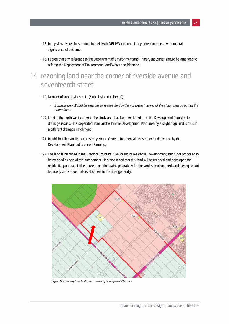
returning from work Accessible by public transport
HillPDA memo dated March 28, 2011
31. As discussed further in Section 7 of this report, the distance between the Fifteenth Street commercial spine and any new centre, was also an important consideration in locating the Centre. The aim is a location that balances the competing objectives of a central location along Sixteenth Street, between Riverside Avenue and Deakin Avenue, and maximising the distance from the Fifteenth Street precinct for commercial viability reasons. This suggests a location to the north-west of the central position between those two roads.
32. As a result the Centre was identified in its current location. An alternate location at the corner of Walnut Avenue was also exhibited during the evolution of the PSP. That option received considerable objection from the community
4.2 why is the primary school where it is
33. Whilst there is general acknowledgment that a new primary school will be required in the Mildura South precinct, there is considerable debate amongst stakeholders as to when the school will be required. Feedback from the Department of Education during consultation for the PSP indicated that it did not anticipate a school being required in the short term, given capacity at the Lake Primary School and the Irymple Primary School. The Education Department also indicated it would prefer the location to be separated from the existing Mildura South Primary School, with San Mateo Avenue identified as a preferred location. In addition, a series of parameters were identified by the Department and clarified through the PSP process. These were: A land size of minimum 3.5ha, or 3.8-4.0ha if other facilities are to be provided on site. Abuttal to three street frontages. Co-location with open space and / or community facilities where possible.
34. In the context of Mildura South, the location of the primary school proximate to the recreation reserve was considered ideal and the location identified on the plan best fulfilled the identified criteria.
35. It is important to note also that a potential non-government school has also been identified in the Development Plan area. This is both in response to community and stakeholder concern regarding the need
mildura amendment c75 | hansen partnership 8
urban planning | urban design | landscape architecture
for another school in the shorter term but also the particulars of that land, namely its status as 'college lease' land.
4.3 why has council adopted a density of 15dph, should it be lower as per other regional towns
36. The Mildura South Strategic Framework Plan prepared in 2007 identified a relatively low density of 3.5 lots per acre, which equates to just under 9 lots per hectare.
37. Since the preparation of the previous Strategic Framework Plan, the density to be achieved in urban growth areas identified by State planning policy has increased to 15 dwellings per hectare.
38. While an overall density of 15 dwellings per hectare is sought in the PSP, I note the intent of proposed changes to the Mildura Planning Scheme by Amendment C89, which implements the Mildura Housing and Settlement Strategy (2014) (MHSS). The principles contained in the Housing Strategy are reflected in the Mildura South Development Plan. The aim is to achieve an overall density of 15 lots per hectare, but by providing a range of lot sizes, including small areas of higher density housing, as well as areas of lower density dwellings.
39. Consideration of the broader planning context through the preparation of the PSP, confirmed that the Mildura South growth area had an important role to play in accommodating urban growth in the region, and that the efficient use of land was an important. The context of Mildura is quite different to other regional centres throughout Victoria: It is the only major urban centre for up to 200km in all directions, that provides a full range of services
and facilities for existing and future residents. This means that are few options for ‘urban living’ elsewhere in the region, apart from Mildura.
It has a large agricultural hinterland undergoing significant change and restructuring, the population of which relies heavily on Mildura as a service centre. This also results in Mildura being the destination, as older residents move from agricultural areas to access services, facilities and health care, which are not available in other parts of the municipality.
Mildura has significant constraints to long term growth, namely: the airport to the south; the Murray River to the north; irrigated agricultural areas to the south and east; and Lakes Hawthorn and Ranfurly to the west. Whilst a significant area has been identified for long term growth in Mildura East, in the Mildura Housing and Settlement Strategy, the efficient use of future urban land remains a relevant consideration in Mildura.
Given the flat nature of the terrain, drainage infrastructure presents a particularly high cost for urban and related development in Mildura. The higher the density of development the greater is the ability to accommodate this cost of drainage and other infrastructure.
40. Having regard to these considerations I am comfortable that it is appropriate to seek a density of 15 lots per hectare in growth areas in Mildura.
mildura amendment c75 | hansen partnership 9
urban planning | urban design | landscape architecture
4.4 what is the area of open space provided in % terms
41. The area of open space provided for the Mildura South area is outlined below.
42. Precinct Structure Plan: Net developable area = 408.3 hectares Area of open space = 30.5 hectares Proportion of open space = 7.5%
43. Development Plan Area: Net developable area = 169.7 hectares Area of open space = 10.5 hectares Proportion of open space = 6.2%
44. The areas of open space comprise the following: Sixteenth Street North Village Green = 2 hectares in Development Plan area. Recreation reserve (noting 8 hectares already owned by Council, with land also used for drainage
purposes) = 12 hectares. Major local open spaces = 6 hectares in two parks in Development Plan area, one in other stages of
the growth area. Local open spaces = 9 hectares in three parks in Development Plan area, six in other stages of the
growth area. Gateway water feature park (Riverside Avenue) = 1.5 hectares in Development Plan area. Green belt = An exact area has not been allocated to this feature, which separates residential from
industrial land along Benetook Avenue. This is anticipated to be determined during the preparation of a development plan for this later stage of development.
45. The following is also noted: An additional 4 hectares of land required for drainage purposes at the intersection of Deakin Avenue
and Sixteenth Street, is identified as also providing some recreational opportunities (Gateway water feature park). However this function will be secondary to the drainage function, so it is not been included in the calculation of open space. An additional area for drainage is also identified between Etiwanda and Benetook Avenues.
There was very little public open space provided in the first stage of Mildura South. I understand that this was a key concern raised by the community and stakeholders during the preparation of the PSP. This is likely to influence the use of open space provided closer to Sixteenth Street.
There is the future possibility of land around Lake Hawthorn becoming available for recreational purposes. However this would need to be subject to further investigations, give the environmental sensitives of the area.
mildura amendment c75 | hansen partnership 10
urban planning | urban design | landscape architecture
4.5 why the choice of ugz for nac area
46. The UGZ was identified for the NAC as a 'best fit' from the available suite of zones. The land is currently zoned General Residential.
47. Under the provisions of the existing General Residential Zone, landowners could apply and could gain a planning permit for a residential subdivision, thus preventing the establishment of a NAC on the land. This would exacerbate the current situation whereby very few services and facilities have been provided as part of the earlier stages of development in the wider Mildura South area.
48. In my opinion it would be premature to rezone the site of the proposed NAC into specific zones now (i.e. Commercial 1, General Residential, Public Park and Recreation Zone etc), before a more detailed master plan has been prepared for the site. Further, I do not believe it is appropriate to retain the site of the proposed NAC in a Residential General Zone, now that the site has been identified for a NAC.
49. The drafted UGZ allows Council to manage the land to ensure it develops consistently with the anticipated master plan for this activity centre.
4.6 why aren’t other farming zoned areas in the precinct proposed for rezoning at this time
50. The only areas within the study area that are currently included within a General Residential Zone, are those areas for which the drainage strategy for Mildura South is being implement. All other land remains in a Farming Zone. Land currently zoned Farming will be progressively rezoned once the drainage strategy is implemented. Rezoning of the land will also be influenced by the need to bring additional land on-stream, to accommodate orderly and sequential residential development.
4.7 where does the mildura south precinct sit in terms of the broader mildura housing strategy and the supply and demand for housing in the mildura area
51. Mildura South is the main existing and planned residential growth area in Mildura, and has been for the past decade or so. Approval of the Mildura South (Sixteenth & Deakin West) Development Plan, will enable the growth that has occurred in Mildura South to date, to continue to the south-west of Sixteenth Street.
52. The Mildura Housing and Settlement Strategy generally provides for future residential development in Mildura to be accommodated in three different ways (p13): The existing Mildura South Growth front. The proposed new Mildura East Growth Area. Ongoing consolidation and infill within established urban areas.
mildura amendment c75 | hansen partnership 11
urban planning | urban design | landscape architecture
53. The Mildura South Growth Area is the main short to medium term growth area identified in the Housing Strategy. The Strategy does, however, identity a new second major growth front to the east of Mildura. No land in that area has as yet zoned for residential development. Considerable investigations are required before rezoning and residential development occurs in that growth area, namely the preparation of a drainage strategy and the subsequent precinct structure plan.
Figure 1 - Mildura Housing and Settlement Strategy Framework Plan
mildura amendment c75 | hansen partnership 12
urban planning | urban design | landscape architecture
4.8 is there an intention to prepare a development contributions plan for mildura south
54. There are a series of relatively old development contributions plans that apply to most undeveloped land to the south and east of Mildura.
55. The Mildura South PSP area is covered by Development Contributions Plan Overlays 1 and 2. These overlays apply to a broader area than just the Mildura South PSP area.
56. The development contributions plan that underlies those overlays, was prepared for the wider Mildura South area by SGS in 2003. Council has been collecting funds under that document for a number of years. I understand that the Plan identified only basic infrastructure for the area, including some roads, drainage, open space and a basic levy for community infrastructure. As a consequence there is a significant shortfall that needs to be made up by Council. The implications of the development plan for the exiting DCPs, were examined and identified some additional cost implications regarding implementation (Development Plan report, p 52). The consequence of this is that there would be additional costs for Council, but not for developers.
4.9 is there an intention to place a floor space limit on ‘shop’ in the schedule to the commercial 1 zone (which applies under the ugz)
57. There is no intention to place a floor space cap in the schedule to the Commercial 1 Zone for the Mildura South Neighbourhood Activity Centre.
58. The proposed Schedule 1 to the Urban Growth Zone includes the following requirements:
The precise boundary of the Commercial 1 Zone, Public Use Zone and Residential Growth Zone will be determined by the Urban Design Framework / Master Plan approved under Clause 3.0 of this schedule.
If land is identified as part of the neighbourhood activity centre on Map 1, a permit must not be granted to use or subdivide land, or to construct a building or construct and carry out works until an Urban Design Framework / Master Plan for the activity centre has been prepared to the satisfaction of the responsible authority.
59. The boundaries of the Commercial 1 Zone will be determined when the Master Plan is prepared for the activity centre. It is envisaged that the boundaries of the zone will effectively ‘limit’ the retail floor space of the centre and there will be no need to include a floor space limit in the schedule to the zone. If for some reason this is not the case, the option exists to include a cap in the schedule at that time.
mildura amendment c75 | hansen partnership 13
urban planning | urban design | landscape architecture
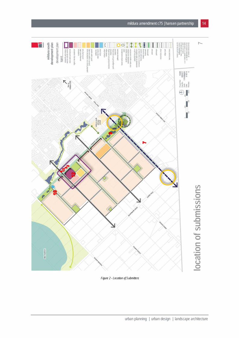
5 submissions 60. A total of 13 submissions received to the amendment (see Figure 2).
61. Of those submissions, 5 either supported the amendment or were neutral (Submission Numbers 1, 5, 6, 8, and 11).
62. The main issues raised by the remaining 7 submissions are summarised as follows: Location of Neighbourhood Activity Centre (NAC) opposite existing houses in Sixteenth Street (2
submissions, Numbers 2, 3, 4 and 13). Location of the NAC at south corner of Sixteenth Street and Ontario Avenue: (2 submissions, Numbers
4, 12). Layout of the NAC (1 submission, Number 4). Need for a NAC (1 submission, Number 12). Use of the Urban Growth Zone on the NAC site (2 submissions, Numbers 4, 12). Need for / appropriateness of a Precinct Structure Plan (1 submission, Number 10). Land acquisition (2 submission, Numbers 7 and 9). Size of drainage basin on north corner of Sixteenth Street and Walnut Avenue (1 submission, Number
9). Location of Major Local Open Space between Riverside Avenue and Ontario Avenue (1 submission,
Number 10). Native vegetation at the corner of Sixteenth Street and Riverside Avenue (1 submission, Number 6). Rezoning land near the corner of Riverside Avenue and Seventeenth Street (1 submission, Number
10).
63. I address each of these submissions in the balance of my report.
mildura amendment c75 | hansen partnership 14
urban planning | urban design | landscape architecture
Figure 2 - Location of Submitters

mildura amendment c75 | hansen partnership 15
urban planning | urban design | landscape architecture
6 the need for a neighbourhood activity centre 64. Number of submissions = 1 (Submission Number 12).
65. The sentiments expressed in this submission include the following:
Reasoning behind locating a full-line supermarket on the site is questionable.
Submission refers to different catchment penetration figures in other Hill PDA Reports.
Refers to the site being 2km from 15th Street, whereas Retail Needs Assessment, Department of Housing 2011, refers to accepted distance of 3 kilometres for two full-one supermarkets.
66. I have referred this submission to Hill PDA, who were responsible for preparing a retail overview as part of the preparation of the PSP. In response to the matters raised in the submission referring to different rates of catchment penetration used in other Hill PDA reports, Hill PDA’s comment was as follows:
“The reports referred to relate to retailing in Liverpool LGA (NSW) and Silverwater in Auburn LGA (NSW). Both of these areas have access to significantly higher provision of competing retail floor space and destinations in the broader Sydney metropolitan area than Mildura South does. It would not be unreasonable to expect that the proportion of resident supermarket spending captured within the catchment areas in the HillPDA 2011 and 2014 reports to be lower than in Mildura South.”
67. Further discussions with Hill PDA confirm that no matters have been raised in Submission 12 that would cause it to alter its view that a supermarket based NAC can be supported in the Mildura South Area.
68. I believe that it is also relevant that: The Mildura Retail Strategy (Essential Economics 2010) identified the potential for the Mildura South
area to support a NAC within a full line supermarket. The Growth Area Authorities Precinct Structure Planning Guidelines include a standard that “80-90% of
households should be within 1km of an activity centre of sufficient size to allow for provision of a supermarket.”
69. A NAC is required to be provided to meet the needs of existing and future residents of the Mildura South Growth area. In my opinion it is an essential and an intrinsic element of the growth area. The establishment of a NAC in Mildura South will also provide a catalyst for the provision of a wider variety and density of housing than would be possible if the area was solely residential.
70. From a strategic planning perspective, even if there was some validity in the submission about the ‘flawed’ nature of the economic analysis (which I do not believe there), in my opinion it would go more to the size and the retail composition of the centre, than to the need for the Centre per sae.
mildura amendment c75 | hansen partnership 16
urban planning | urban design | landscape architecture
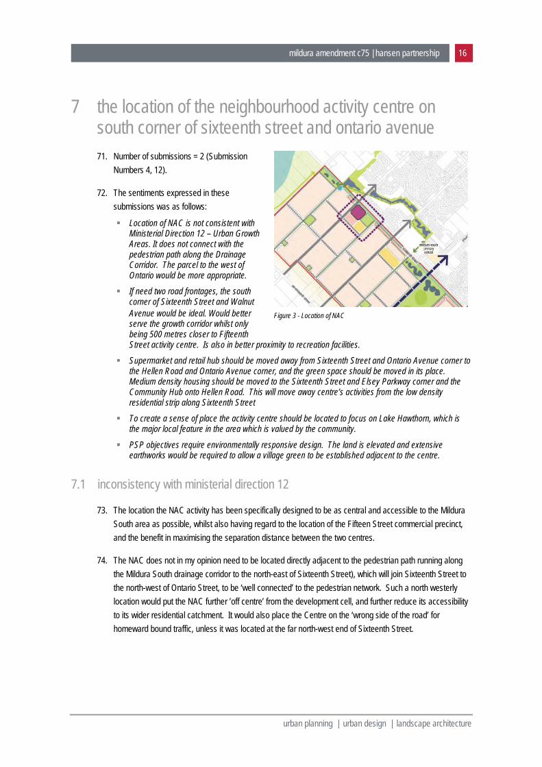
7 the location of the neighbourhood activity centre on south corner of sixteenth street and ontario avenue 71. Number of submissions = 2 (Submission
Numbers 4, 12).
72. The sentiments expressed in these submissions was as follows:
Location of NAC is not consistent with Ministerial Direction 12 – Urban Growth Areas. It does not connect with the pedestrian path along the Drainage Corridor. The parcel to the west of Ontario would be more appropriate.
If need two road frontages, the south corner of Sixteenth Street and Walnut Avenue would be ideal. Would better serve the growth corridor whilst only being 500 metres closer to Fifteenth Street activity centre. Is also in better proximity to recreation facilities.
Supermarket and retail hub should be moved away from Sixteenth Street and Ontario Avenue corner to the Hellen Road and Ontario Avenue corner, and the green space should be moved in its place. Medium density housing should be moved to the Sixteenth Street and Elsey Parkway corner and the Community Hub onto Hellen Road. This will move away centre’s activities from the low density residential strip along Sixteenth Street
To create a sense of place the activity centre should be located to focus on Lake Hawthorn, which is the major local feature in the area which is valued by the community.
PSP objectives require environmentally responsive design. The land is elevated and extensive earthworks would be required to allow a village green to be established adjacent to the centre.
7.1 inconsistency with ministerial direction 12
73. The location the NAC activity has been specifically designed to be as central and accessible to the Mildura South area as possible, whilst also having regard to the location of the Fifteen Street commercial precinct, and the benefit in maximising the separation distance between the two centres.
74. The NAC does not in my opinion need to be located directly adjacent to the pedestrian path running along the Mildura South drainage corridor to the north-east of Sixteenth Street), which will join Sixteenth Street to the north-west of Ontario Street, to be ‘well connected’ to the pedestrian network. Such a north westerly location would put the NAC further ’off centre’ from the development cell, and further reduce its accessibility to its wider residential catchment. It would also place the Centre on the ‘wrong side of the road’ for homeward bound traffic, unless it was located at the far north-west end of Sixteenth Street.
Figure 3 - Location of NAC
mildura amendment c75 | hansen partnership 17
urban planning | urban design | landscape architecture
7.2 previous exhibition of an alternative location
75. I note that during the process of preparing the PSP, a version of the plan was prepared and exhibited that showed the NAC located on the west corner of Sixteenth Street and Walnut Avenue. Some 19 of 29 submissions made to that version of the PSP, supported the original (Ontario Avenue) location. As a consequence, the exhibited version of the PSP shows the Centre being in the initially ‘preferred located’, on the south corner of Sixteenth Street and Ontario Avenue.
76. From a strategic planning perspective the aim is a location that balances the competing objectives of a central location along Sixteenth Street, between Riverside Avenue and Deakin Avenue, and maximising the distance from the Fifteenth Street precinct for commercial viability reasons. This suggests a location to the west of the central position between those two roads. In my opinion, the exhibited location on the south side of Ontario Avenue, best meets this aim.
7.3 a location on Lake Hawthorn
77. A location focussed on Lake Hawthorn, as suggested in Submission 12, would place the NCA at the far north-west extremity of urban development in Mildura South. It would be off-centre from its residential catchment, which would significantly reduce its accessibility to its residential surrounds. It would effectively result in a ‘one sided’ catchment, which is problematic from an access and a retail planning perspective.
78. The Mildura CBD, being located adjacent to the Murray River, is an example of a centre with a one sided catchment. The Mildura CBD is struggling to retain its primacy in the retail and business hierarchy in Mildura, due to the emergence of the more centrally located Fifteenth Street precinct.
Figure 4 - NAC on Lake Hawthorn
mildura amendment c75 | hansen partnership 18
urban planning | urban design | landscape architecture
7.4 a more southerly location
79. In my opinion it is fundamental to the accessibility of the Centre to its wider catchment, and to its commercial success, that the Centre be located on Sixteenth Street, at the intersection with another main road. It is not appropriate to relocate the centre further to the south within the currently ‘undeveloped area’ (i.e. Esley Parkway). This would reduce its accessibility and its centrality to its wider catchment, that extends to the north of Sixteenth Street as well.
7.5 the slope and elevation of the land
80. I do not consider that the land is excessively steep to make it impractical to establish an activity centre and adjacent area of open space on the proposed site of the NAC.
81. The slope of land in this area is gentle. It will not present any unreasonable constraints or earthworks requirements to the establishment of a ‘village green’ as part of the activity centre.
82. I acknowledge that the location of the site does have a slight elevation. I believe that rather than being a constraint to the establishment of an NAC, a site with a slight elevation is a positive response to the features of the area, as the Centre is planned to be the community focal point of this part of Mildura.
Figure 6 – Photo looking south-west along Sixteenth Street towards the NAC site at the top of a slight rise, from near Ontario Avenue
Figure 5 - NAC further to the south
mildura amendment c75 | hansen partnership 19
urban planning | urban design | landscape architecture
8 the location of the neighbourhood activity centre opposite existing houses in sixteenth street 83. Total number of submissions = 4
(Submission Numbers 2, 3, 4 and 13).
84. The sentiment expressed in these submissions includes the following:
Opposed, as it will impact on present quality of lifestyle.
Purchased the property in a quiet residential area.
Would be viewing shops etc. which is not a nice prospect.
Increased traffic / car, bus noise will be horrendous as it becomes a busy arterial road.
Worry about crime rate.
All park / community areas are a target for vandals etc.
See the need for such developments in growth area, but should be built where new residents are moving into the area know it is going to be there.
Would not have bought here if new there was going to be a shopping centre.
Little consideration has been given to the appropriateness of developing a new neighbourhood centre adjacent to existing low density housing.
Sixteenth Street will become more of a thoroughfare for heavy vehicle traffic delivering to the site. Noise and light spill will be an issue. No thought has been given to adverse amenity impacts.
85. I acknowledge that existing dwellings on the opposite side of Sixteenth Street, front the north-east side of the street and will be ‘over the road’ from the proposed NAC. I also acknowledge that the previous Mildura South Strategic Framework Plan identified a smaller activity centre in Sixteenth Street, further to the south-east to that now proposed i.e. on the west corner of Sixteenth Street and Walnut Avenue.
86. Sixteenth Street is planned to become the major ‘cross road’ that will serve the wider Mildura South area, including both existing and newly developing areas. It is proposed to be designed as an attractive ‘greenway’. It will comprise a 30 metre reservation width, an off-centre two way road (one lane in each direction), with 7 metres of landscaping / paths on the north-east side and 15.5 metres of landscaping and paths on the south-west side of the street. It is planned to include three rows of canopy trees within the road reserve.
Figure 7 - Submitters opposite proposed NAC
mildura amendment c75 | hansen partnership 20
urban planning | urban design | landscape architecture
87. A site along the south-west side of Sixteenth Street is the most appropriate location for a NAC, as the land is vacant and undeveloped, Sixteenth Street is centrally located within the broader Mildura South locality and will provide good levels of accessibility to the wider area. As Sixteenth Street is planned to be a higher order road, it will provide excellent levels of exposure / access to passing traffic, as well as being a potential public transport route.
88. Advice from the Study Team’s retail consultants, and good planning practice, suggests that the Centre should be located at the intersection of two main roads, and should be located on the ‘outward bound’ (home journey side) of the main roads.
89. The only place along Sixteenth Street where houses are not either presently existing or proposed to front the opposite side of the street, is to the north-west of Ontario Avenue towards Riverside Avenue, where a linear drainage / open space corridor will front the north-east side of Sixteenth Street. That location is closer to the western extremity of Sixteenth Street, closer to what will become the western edge of urban Mildura. I do not believe that location would provide the same level of accessibility to the wider growth area as the currently proposed site. In addition, it would not enable the centre to be located on the ‘outbound’’ side of the road, unless it was located at the north-west end extremity of Sixteenth Street, at its intersection with Riverside Avenue. That would be too far to the north-west.
90. Any other location along the south-west side of the Sixteenth Street will face a similar situation to that proposed, with housing fronting the other side of the street.
Figure 8 - Sixteenth Street cross section (PSP)
mildura amendment c75 | hansen partnership 21
urban planning | urban design | landscape architecture
91. The NAC will be designed to provide a safe and functional layout, to become a desirable community focal point, to have a high level of amenity, and to respond to surrounding uses such as existing residents on the opposite side of Sixteenth Street. As Sixteenth Street is upgraded to its ultimate alignment, as development occurs on both sides of the street, and as traffic volumes increase, the character and amenity of the street will inevitably change compared to the existing situation. The road itself will provide somewhat of a buffer between dwellings on one side and an activity centre on the other.
92. I consider the proposed location of the NAC on Sixteenth Street to result in a higher net community benefit than other possible locations along the street. The Centre should definitely not be located on another site further to the north-west along Sixteenth Street, away from existing houses, or further to the south-west, within the body of the yet to be developed part of Mildura South.
Figure 9 - Photo of new dwellings on the 'opposite' / north-east side of Sixteenth Street (looking north-east towards Lake Hawthorn)
mildura amendment c75 | hansen partnership 22
urban planning | urban design | landscape architecture
9 the layout of the nac 93. Number of submissions = 1 (Submission Number 4).
94. The sentiments expressed this submission includes the following:
The Development Plan does not adequately resolve the amenity concerns of the exiting community or take into account their existing conditions.
Layout plan for the NAC is not credible, with concealed car parking behind the medium density residential development. Is more likely the centre will have car parking orientated to the street frontages.
Poor location of the NAC as balance of the land to be developed is to the south and there is only a small slither of land to the north, between Sixteenth Street and the drainage retention ponds.
Redesign of NAC – If NAC is to remain on the site, it should be redesigned to minimise amenity concerns of existing residents to the east.
Ninety degree parking should be removed from Sixteenth Street, in favour or parallel parking.
No access should be allowed to the NAC from vehicles from the Sixteenth Street frontage. Traffic should be directed in from Ontario Avenue, Hellen Road and Esley Parkway.
Figure 10 - Neighbourhood Activity Centre Indicative Layout (Development Plan (p 37)
mildura amendment c75 | hansen partnership 23
urban planning | urban design | landscape architecture
95. The layout for the centre shown in the Development Plan report is indicative only. The Development Plan recommends that a master plan be prepared for the Centre, before it can be developed. This requirement is included in the planning scheme amendment (Clause 21.04-2). Amenity considerations of houses on the opposite side of Sixteenth Street can and should be taken into account when a master plan is prepared for the NAC.
10 use of the urban growth zone on the nac site 96. Number of submissions = 2. (Submission numbers 4, 12)
97. Sentiments expressed in the submissions include the following: Object to the rezoning of the NAC site from a General Residential Zone to an Urban Growth Zone.
Proposed residential development can take place within a General Residential Zone. Activity Centre should be zoned Commercial 1, limiting the centre to a specified area on the southern corner of Walnut Avenue and Fifteenth Street. The remainder of the site that is not currently within a residential zone can be incorporate into the Urban Growth Zone.
Object to rezoning of from a General Residential Zone to an Urban Growth Zone (Schedule 1).
Rezoning is flawed and breaches planning guidelines.
98. In my opinion it would be premature to rezone the site of the proposed NAC into specific zones now (i.e. Commercial 1, General Residential, Public Park and Recreation Zone etc), before a more detailed master plan has been prepared for the site.
99. Further, I do not believe it is appropriate to retain the site of the proposed NAC in a Residential General Zone, now that the site has been identified for a NAC. A fundamental purpose of the zoning of land is to indicate the preferred future use of land. Now that the Development Plan has identified the land as the site for NAC, it would be inappropriate and misleading to retain it in a General Residential Zone.
100. In addition, if the land was retained in a General Residential Zone, Council would have little ability to do anything other than issue a planning permit for a residential subdivision, should such an application be lodged. This would prevent NAC from being established on the site.
101. The rezoning of the land is not flawed and is not in not breach planning guidelines. The Precinct Structure Plan and more detailed Development Plan have been prepared having regard to the Growth Area Authority’s Precinct Structure Planning Guidelines, as far as relevant to a regional centre such as Mildura, and given the particular circumstances relevant to the Mildura South area, which include the fact that the land has existed in a residential zone, with a Development Plan Overlay, for many years. Figure 11 - Proposed Urban Growth 1 Zone
mildura amendment c75 | hansen partnership 24
urban planning | urban design | landscape architecture
11 need for a precinct structure plan 102. Total = 1. (Submission number 10)
103. The sentiments expressed in this submission is as follows:
Amendment presents an unconventional arrangement of planning tools which may be contrary to the VPPs.
Unclear why a PSP is required over their Clients land when it is zoned General Residential as opposed to an Urban Growth Zone and has an approved development plan under an existing Development Plan Overlay.
Unsure whether the Development Plan adopted by Council in 2014 and the PSP are identical, which they appear to be. If they are identical the PSP is redundant.
Unclear how a PSP is triggered and becomes a relevant planning consideration without an Urban Growth Zone, other than as part of the PSP.
Would be sensible to rezone land in the north-west corner of the study area as part of this amendment.
104. The reason a PSP is required over the land is to coordinate development of land to the north-west of Deakin Avenue, with development of the wider Mildura South area, which extends to the south-east of Deakin Avenue. The PSP provides an overarching framework that enables a more detailed Development Plan to be prepared, having regard to what might happen in the future, to the south-east of Deakin Avenue. The PSP will have the status of an incorporated document in the planning scheme. The Development Plan will be approved by Council pursuant to the provisions of the Development Plan Overlay.
105. The submission made about the ‘trigger’ for a PSP when the land is not included in an Urban Growth Zone, raises a matter of terminology. Whether the Precinct Structure Plan is called a Precinct Structure Plan a Structure Plan, or has some other title, does not make the plan prepared as part of this project flawed or reduce its relevance. Strategic planning in Victoria has for a long time relied on a hierarchy of different types of strategic plans, of various names, ranging from general overview plans to progressively more detailed plans. The names given to such plans have never been clearly defined either in the Planning and Environment Act or the VPPs. The term Precinct Structure Plan has gained common acceptance in recent times due to the introduction of the Urban Growth Zone and reference to Precinct Structure Plans in other parts of the VPPs. This has been further reinforced by Ministerial Direction 12 and since the GAA (now MPA) has prepared guidelines for preparing Precinct Structure Plans. Clause 11.02-3 of the VPPs has the general heading ‘Structure Planning’. It makes reference to a variety of documents such as structure plans, precinct plans and ‘other relevant plans’. It also uses the terms growth area framework plans, strategic plans, statutory plans, development and conservation plans, development contributions plans and ‘other relevant plans’. It also refers to the ‘preparation of a hierarchy of structure plans or precinct plans’. In addition the VPPs include Development Plan Overlays (DPOs). DPOs are a common means of managing greenfield development, especially in regional Victoria. The provisions of the DPO refer to the need for ‘development plans’ to be prepared prior to the issue of a planning permit. Whilst there may be some confusion in the use of the term Precinct Structure Plan in this amendment, it is clear that the document termed the Mildura South Precinct Structure Plan is a higher level document than a Development Plan. It covers a broader area of land in Mildura South than the Development Plan, including land that is presently zoned Farming and which is not proposed to be rezoned as part of this amendment.
mildura amendment c75 | hansen partnership 25
urban planning | urban design | landscape architecture
106. From a strategic planning perspective, the PSP and the Development Plan are identical as they relate to land to the north-west of Deakin Avenue, albeit the Development Plan report is a more detailed document. The Precinct Structure Plan is not redundant as it also relates to land to the south-east of Deakin Avenue. It will provide guidance in the future, at the time when it is appropriate to rezone and to prepare a development plan for that land.
12 location of open space between riverside avenue and ontario avenue: 107. Number of submissions = 1 (Submission number 10).
Submission - If the PSP does proceed, request a more central location for the public open space currently shown on their land, buy shifting it to the north-east.
108. I acknowledged that the open space shown on land referred to in Submission 10 is not central to land in one ownership. However, the open space is central to land in the wider development cell bounded by Sixteenth Street, Ontario Avenue, Seventeenth Street and Riverside Avenue, as shown on the Precinct Structure Plan.
109. The PSP and Development Plan identify this open space as a “major open space”. This is a larger and a higher order area of open space than a “local open space”, which is also proposed throughout the Development Plan area. Whilst there is some flexibility in the location of open space given that planning permits for subdivision must be “generally in accordance with a development
plan”, it is important that this area of “major local open space” remains in a position that is central to the wider development cell.
110. Hence, in my opinion, it should generally remain at the intersection of the “greenway” and the “secondary road”, as shown on the PSP and on the Development Plan. This will not preclude additional open space from being provided within any development that might occur on the subject land.
Figure 12 - Open space between Riverside Avenue and Ontario Avenue
mildura amendment c75 | hansen partnership 26
urban planning | urban design | landscape architecture
13 native vegetation at the corner of sixteenth street and riverside avenue 111. Number of submissions = 1
(Submission number 6).
112. Sentiments expressed in the submission:
Supports the amendment and provides the following comments.
Land at the corner of Sixteenth Street and Riverside Avenue contains native vegetation and is a potential habitat for the Hooded Scaly Foot, a legless lizard listed as threatened under the Flora and Fauna
Guarantee Act.
All reference to the Department of Environment and Primary Industries in the reports are to be amended to read Department of Environment Land Water and Planning.
113. Land at corner of Sixteenth Street and Riversdale Avenue is not included in an environmental overlay that identifies it as having significant vegetation or ecological values. The land is presently zoned General Residential, after having been zoned Residential 1 by Amendment C28 to the Mildura Planning Scheme in 2005.
114. Pursuant to Clause 52.17 of the Planning Scheme, a planning permit is required to remove any native vegetation. Reference to the Native Vegetation Information Management System indicates that the land has a Native Vegetation Location Risk of A, which is the lowest risk category. Any permit application to remove more than 1 ha or 15 trees, would be a classified as a ‘moderate risk’ and an ecological assessment would be required to be submitted with a permit application. This would enable the ecological values of the land to be assessed prior to any development proceeding. In my opinion, this is sufficient to protect the suggested environmental values of the land.
115. It is not appropriate to include an environmental overlay over land as part of this or any other amendment, until a detailed ecological assessment has been undertaken to verify the existence of features of environmental significance.
116. Ecological assessments were not considered necessary to be prepared as background to the preparation of this Development Plan, as the land has been zoned for residential purposes and has been covered by a Strategic Framework Plan for a considerable period of time.
Figure 13 - Aerial photograph of land between Riverside Avenue and Ontario Avenue
mildura amendment c75 | hansen partnership 27
urban planning | urban design | landscape architecture
117. In my view discussions should be held with DELPW to more clearly determine the environmental significance of this land.
118. I agree that any reference to the Department of Environment and Primary Industries should be amended to refer to the Department of Environment Land Water and Planning.
14 rezoning land near the corner of riverside avenue and seventeenth street 119. Number of submissions = 1. (Submission number 10)
Submission - Would be sensible to rezone land in the north-west corner of the study area as part of this amendment.
120. Land in the north-west corner of the study area has been excluded from the Development Plan due to drainage issues. It is separated from land within the Development Plan area by a slight ridge and is thus in a different drainage catchment.
121. In addition, the land is not presently zoned General Residential, as is other land covered by the Development Plan, but is zoned Farming.
122. The land is identified in the Precinct Structure Plan for future residential development, but is not proposed to be rezoned as part of this amendment. It is envisaged that this land will be rezoned and developed for residential purposes in the future, once the drainage strategy for the land is implemented, and having regard to orderly and sequential development in the area generally.
Figure 14 - Farming Zone land in west corner of Development Plan area

mildura amendment c75 | hansen partnership 28
urban planning | urban design | landscape architecture
15 land acquisition 123. Number of submissions = 1 (Submission Numbers 7 and 9).
Submission 7
Seeks confirmation that Council is seeking to establish a regional recreational reserve on the land, and if so, is Council going to compensate the landowner, and when.
124. A response to this submission is required from Council.
Submission 9
Relates to a 7.9ha site at the south-west corner of Sixteenth Street and Deakin Avenue intersection
125. The submitter want to know:
If the land is in fact required for drainage purposes, it is requested Council acquire the land in the immediate future.
If the sizing of the drainage area cannot be substantiated, that its size be reduced to no more than 2 hectares.
126. A similar submission was made and responded to as part of the informal exhibition of the PSP and Development Plan report before they were adopted by Council.
127. It is my understanding that the original Mildura South Drainage Plan identifies an area of approximately 2ha (or half the block) being required for drainage. This is to provide an ‘overflow’ facility for the main drainage basin to be located on the south-east side of Deakin Avenue. The drainage plan identifies a specific drainage requirement for the land, but does not consider a ‘softer design’ that integrates the basin into a landscaped open space feature. The engineering diagrams prepared for this area identify that to achieve an appropriate design outcome, almost the entire 4ha block will be required. Given the land is unlikely to be inundated for the majority of the time, the Development Plan has sought to use this space as a landscaped open space feature along the Sixteenth Street Greenway. However it is important to acknowledge that the open space function is secondary to the drainage function.
128. Support for prompt acquisition of this land has been identified in previous responses on this matter> However the timing of acquisition of this land will depend on a number of factors and is an internal Council matter for resolution.
mildura amendment c75 | hansen partnership 29
urban planning | urban design | landscape architecture
16 conclusion
129. The Mildura South Precinct Structure Plan and Development Plan are important documents in terms of facilitating the development of the next major residential growth front in Mildura.
130. Amendment C89 presents a generally accurate translation of the Mildura South Precinct Structure Plan project into the planning scheme.
131. Most of the submissions lodged have been in relation to the need for and the location of a neighbourhood activity centre along Sixteenth Street, at its intersection with Ontario Avenue. I believe that such a centre is a critical part of the PSP, will be much need retail as well as community facility in the Mildura south area, and is crucial in terms of achieve a diversity of housing types in the area. The proposed location is the optimal location in the precinct.
132. I have no issues with the application of both a PSP and a Development Plan to the land, or the application of the Urban Growth Zone to the proposed new neighbourhood activity centre.
133. Council needs to respond to a number of specific matters raised in relation to the acquisition of land for open space and drainage purposes, and the purported environmental significance of land between Riverside Avenue and Ontario Avenue.
david barnes managing director btrp(hons); mba; fpia
appendix 1 relevant plans and maps
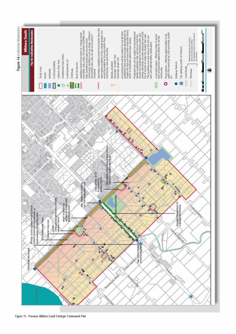
Figure 15 - Previous Mildura South Strategic Framework Plan
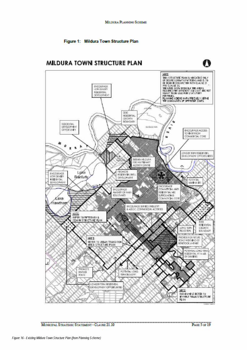
Figure 16 - Existing Mildura Town Structure Plan (from Planning Scheme)
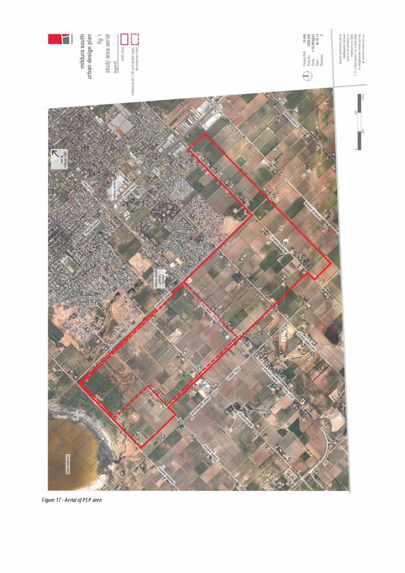
Figure 17 - Aerial of PSP area
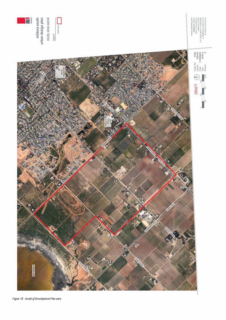
Figure 18 - Aerial of Development Plan area
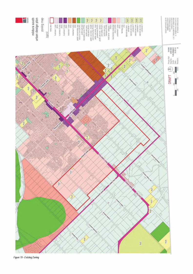
Figure 19 - Existing Zoning
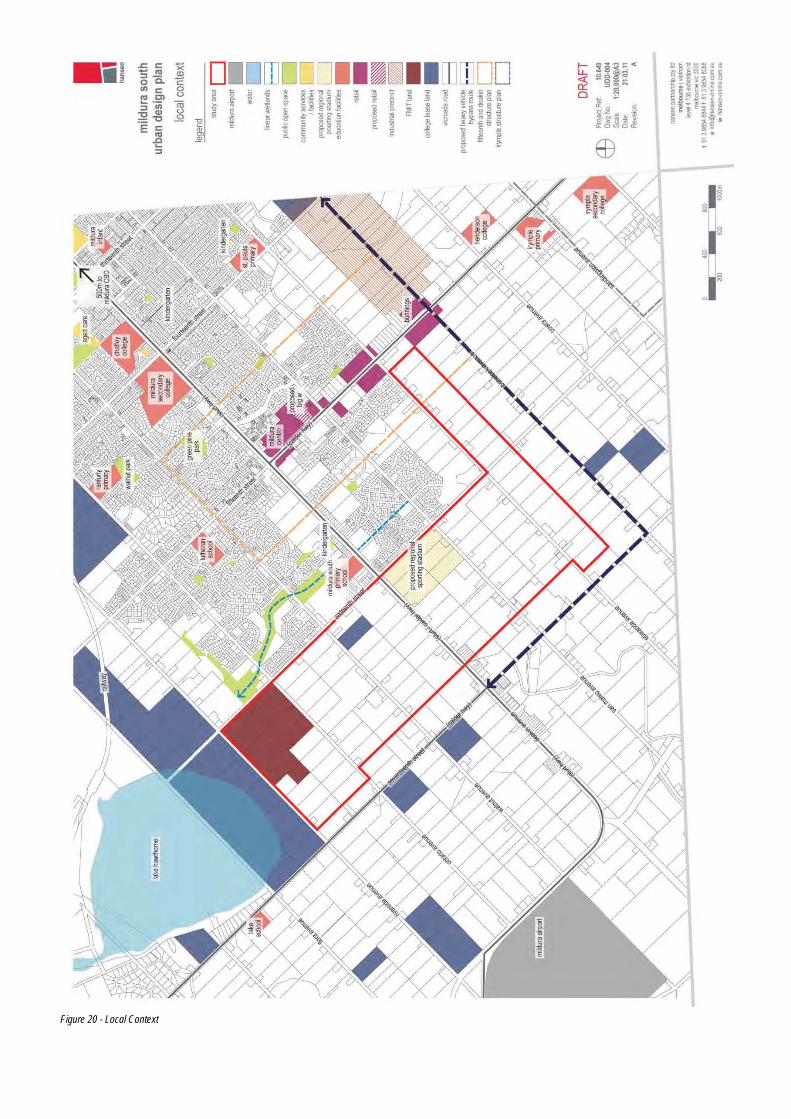
Figure 20 - Local Context
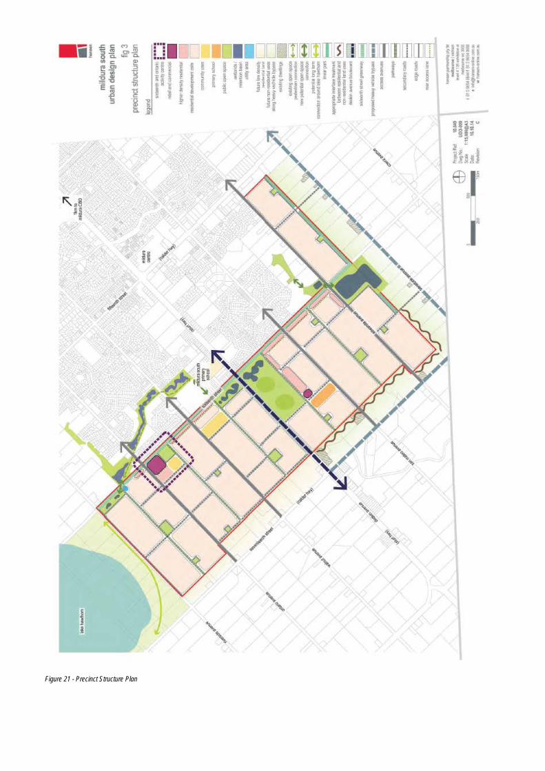
Figure 21 - Precinct Structure Plan
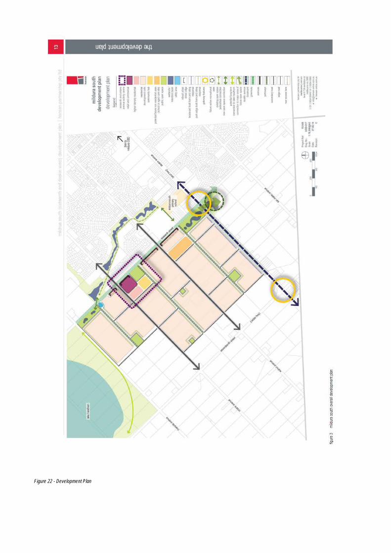
Figure 22 - Development Plan