Embed Size (px)
Citation preview
State Roads Department of State Growth
MIDLAND HIGHWAY PERTH TO BREADALBANE DUPLICATION Submission to the Parliamentary Standing Committee on Public Works Version: 2 Date: September 2015
MIDLAND HIGHWAY PERTH TO BREADALBANE DUPLICATION Submission to the Parliamentary Standing Committee on Public Works
Version: 2 Date: September 2015
Document Development History
Build Status
Version Date Author Reason Sections
1 6/8/2015 Kevin Bourne Original version All
2 16/9/2015 Andrew Fowler Progress update All
Amendments in this Release
Section Title Section Number
Amendment Summary
General All Update for recent progress with approvals
Distribution
Copy No Version Issue Date Issued To
1 1 Damion Beety
1-10 2 16/9/2015 PSCPW
11-13 2 16/9/2015 State Roads officers
MIDLAND HIGHWAY PERTH TO BREADALBANE DUPLICATION Submission to the Parliamentary Standing Committee on Public Works
Version: 2 Date: September 2015
Table of Contents
INTRODUCTION ........................................................................................................................................ 1 1
BACKGROUND ............................................................................................................................................. 1 1.1 PROJECT OBJECTIVES .................................................................................................................................... 1 1.2 PROJECT LOCATION ...................................................................................................................................... 1 1.3 STRATEGIC CONTEXT OF THE PROJECT .............................................................................................................. 3 1.4
PROJECT DETAILS ..................................................................................................................................... 4 2
PROPOSED WORKS ...................................................................................................................................... 4 2.1 DESIGN SPEED ............................................................................................................................................. 4 2.2 ROAD CROSS SECTION .................................................................................................................................. 4 2.3 DRAINAGE .................................................................................................................................................. 6 2.4 UTILITIES .................................................................................................................................................... 6 2.5
SOCIAL, ENVIRONMENTAL IMPACTS AND STAKEHOLDER ENGAGEMENT ................................................. 7 3
PROPERTY ACQUISITION ................................................................................................................................ 7 3.1 NOISE ........................................................................................................................................................ 8 3.2 FLORA ....................................................................................................................................................... 8 3.3 FAUNA....................................................................................................................................................... 8 3.4 ABORIGINAL HERITAGE ................................................................................................................................. 9 3.5 HISTORIC HERITAGE ASSESSMENT ................................................................................................................... 9 3.6 LANDSCAPE AND VISUAL IMPACTS ................................................................................................................... 9 3.7 STAKEHOLDER ENGAGEMENT ....................................................................................................................... 11 3.8 DEVELOPMENT APPROVALS ......................................................................................................................... 11 3.9
PROJECT PROGRAM AND COSTS ............................................................................................................ 12 4
PROJECT PROGRAM.................................................................................................................................... 12 4.1 COSTS ..................................................................................................................................................... 12 4.2
CONCLUSION .......................................................................................................................................... 14 5
Appendices
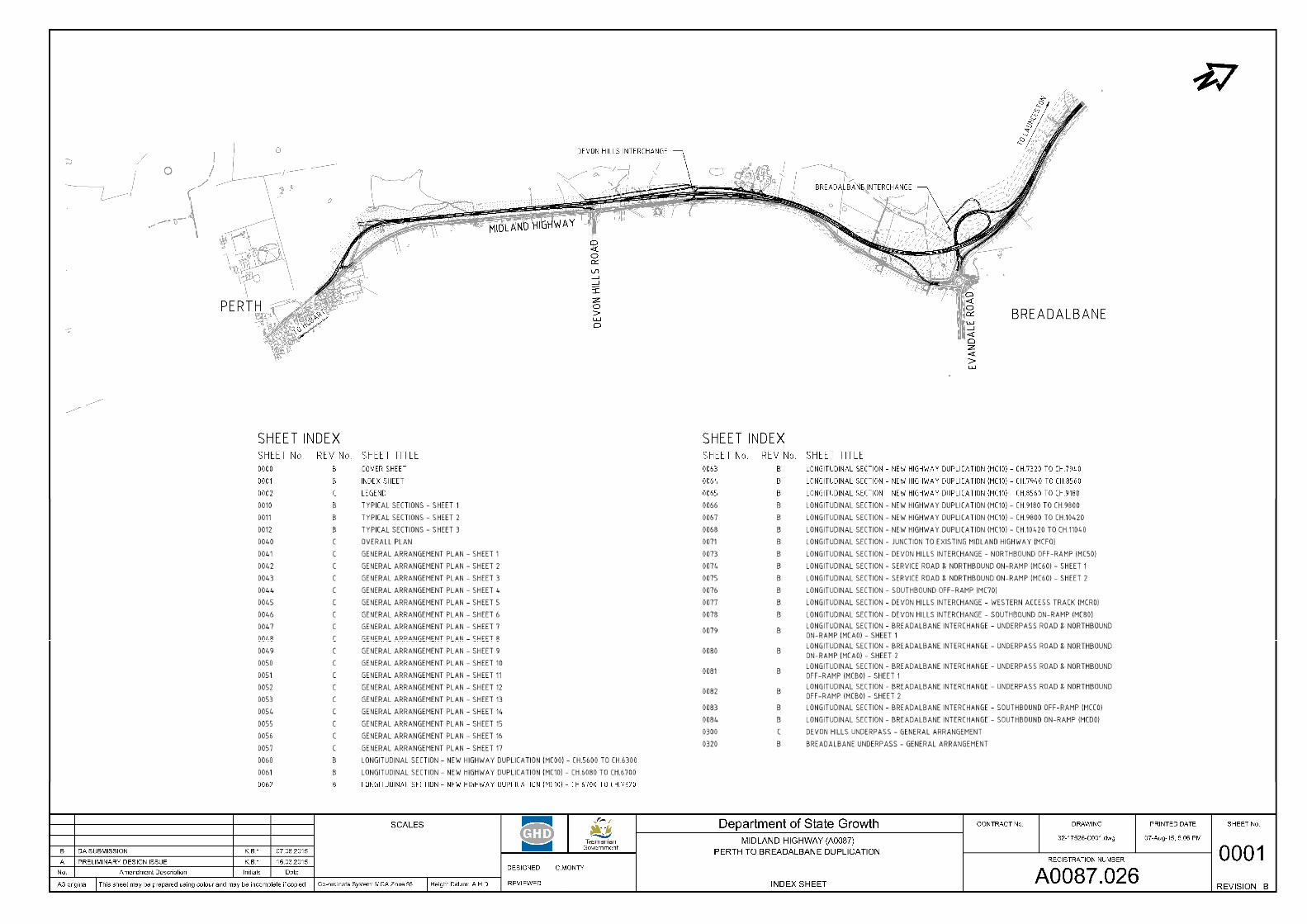
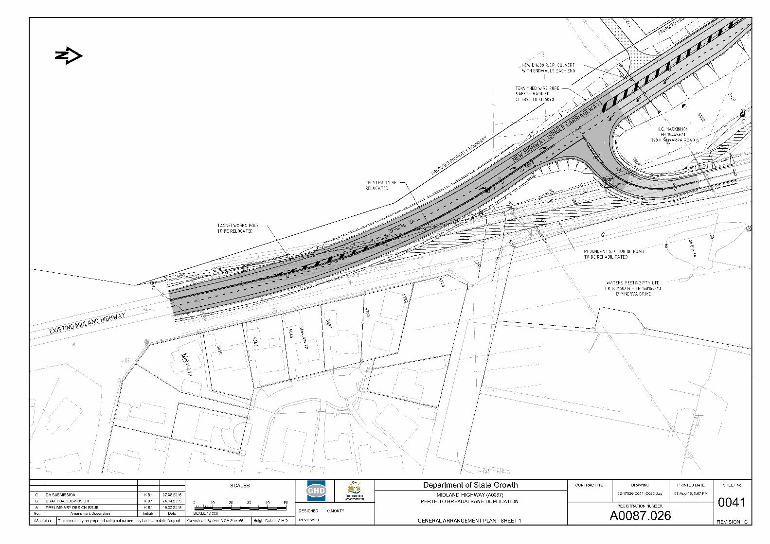
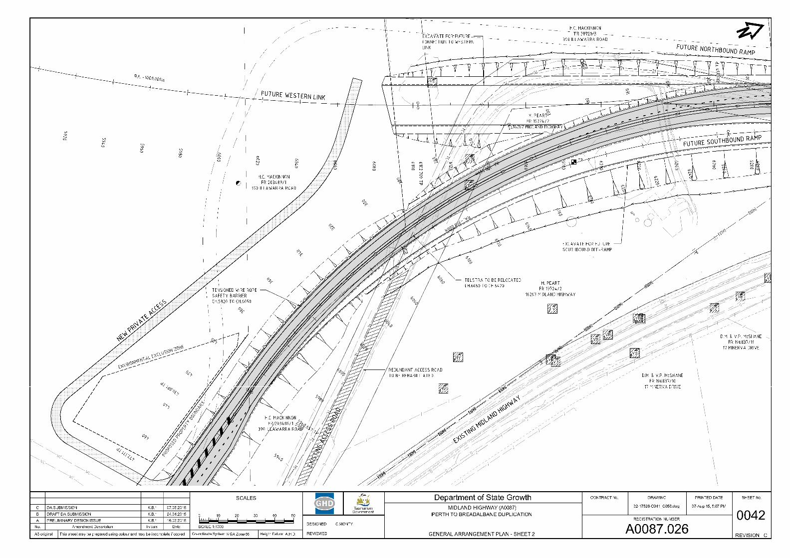
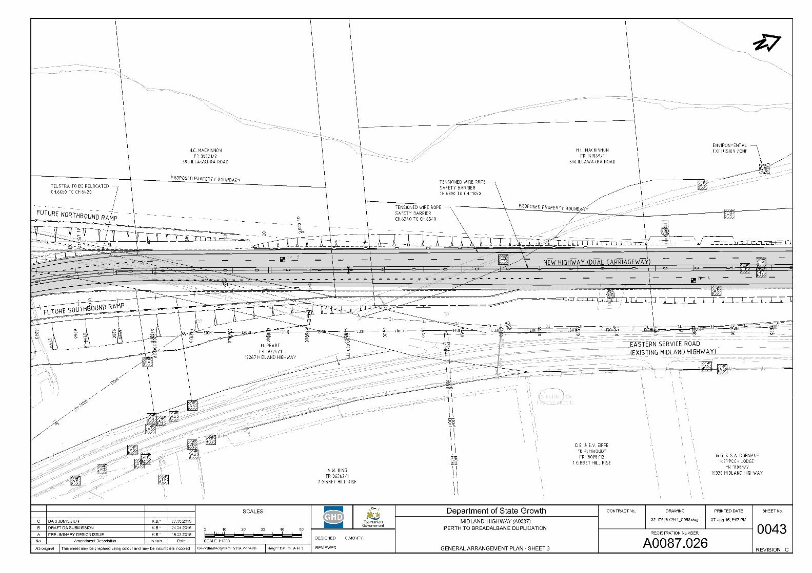
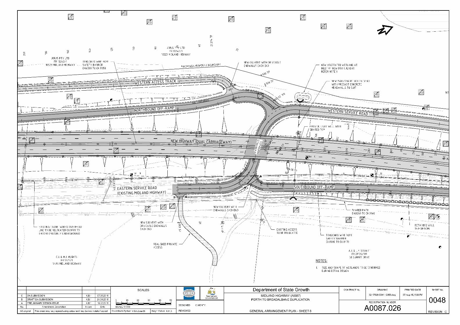
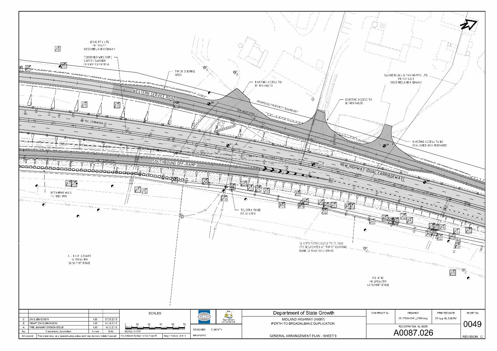
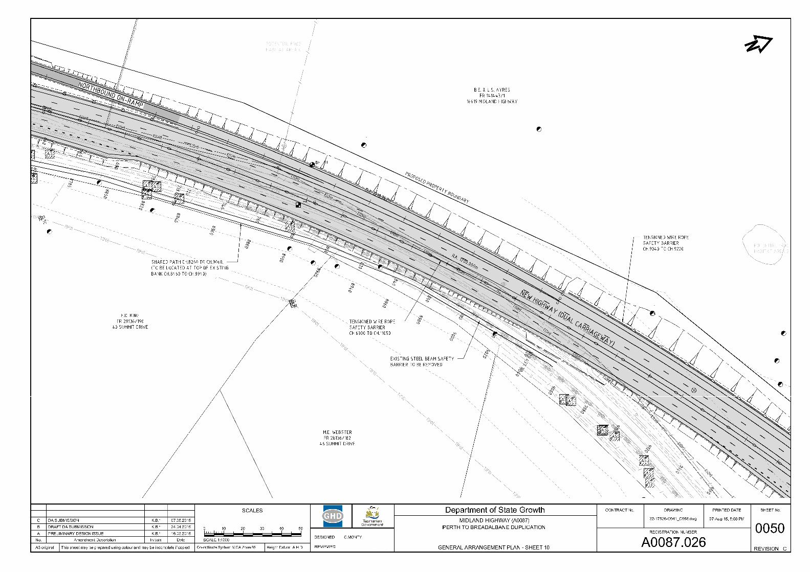
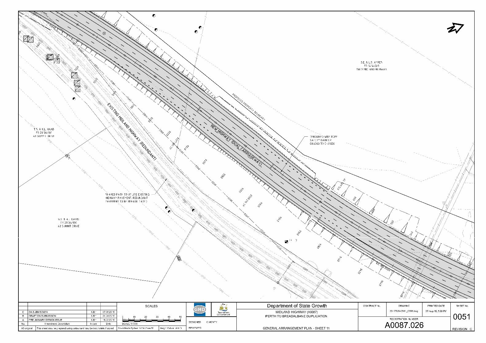
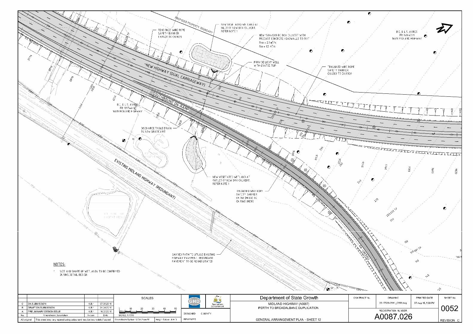
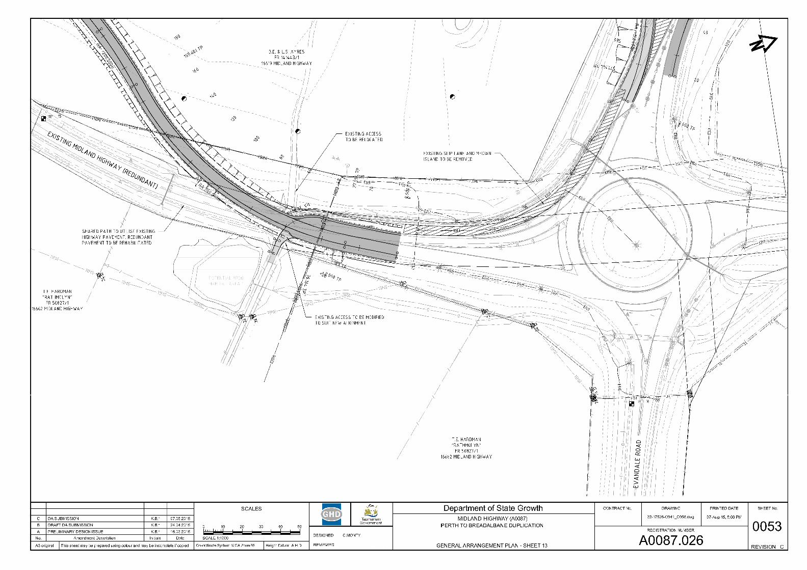
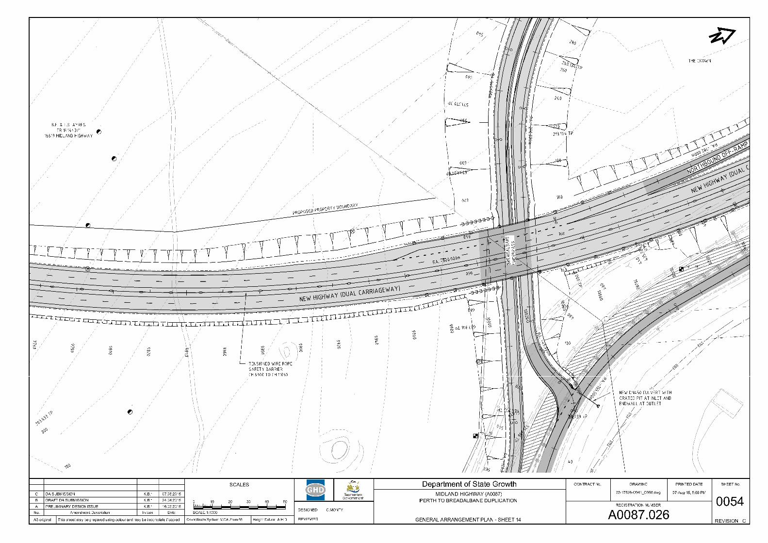
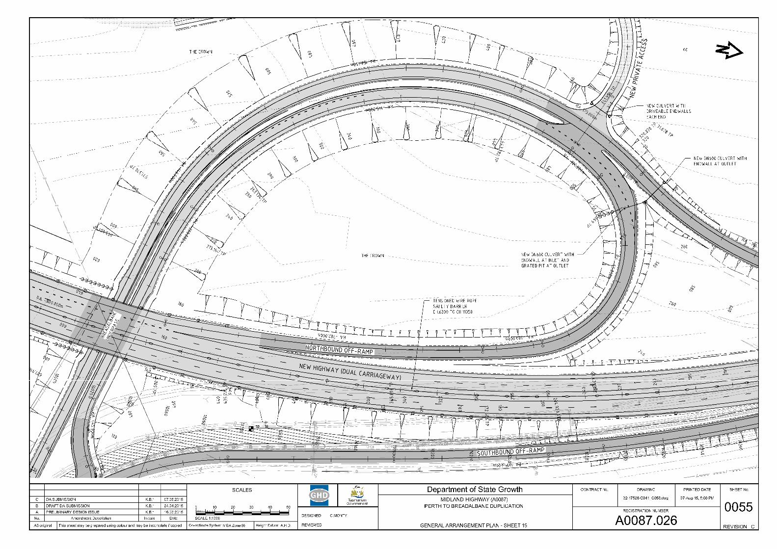
APPENDIX A. DRAWINGS
APPENDIX B. P50 / P 90 COST ESTIMATES
APPENDIX C. STAKEHOLDER CONCERNS
Authorisation
Name Signature Date
Authorised by: Adrian Paine
MIDLAND HIGHWAY PERTH TO BREADALBANE DUPLICATION Submission to the Parliamentary Standing Committee on Public Works
Version: 2 Date: September 2015 Page 1 of 14
Introduction 1
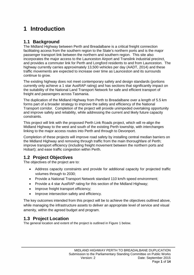
Background 1.1The Midland Highway between Perth and Breadalbane is a critical freight connection facilitating access from the southern region to the State’s northern ports and is the major passenger transport link between the northern and southern region. This site also incorporates the major access to the Launceston Airport and Translink industrial precinct, and provides a commuter link for Perth and Longford residents to and from Launceston. The highway currently carries approximately 13,500 vehicles per day (AADT, 2014) and these traffic movements are expected to increase over time as Launceston and its surrounds continue to grow.
The existing highway does not meet contemporary safety and design standards (portions currently only achieve a 1 star AusRAP rating) and has sections that significantly impact on the suitability of the National Land Transport Network for safe and efficient transport of freight and passengers across Tasmania.
The duplication of the Midland Highway from Perth to Breadalbane over a length of 5.5 km forms part of a broader strategy to improve the safety and efficiency of the National Transport corridor. Completion of the project will provide unimpeded overtaking opportunity and improve safety and reliability, while addressing the current and likely future capacity constraints.
This project will link with the proposed Perth Link Roads project, which will re-align the Midland Highway to the west and south of the existing Perth township, with interchanges linking to the major access routes into Perth and through to Devonport.
Completion of these projects will improve road safety by installing central median barriers on the Midland Highway and removing through traffic from the main thoroughfare of Perth; improve transport efficiency (including freight movement between the northern ports and Hobart); and ease traffic congestion within Perth.
Project Objectives 1.2The objectives of the project are to:
Address capacity constraints and provide for additional capacity for projected traffic volumes through to 2030;
Provide a National Transport Network standard 110 km/h speed environment; Provide a 4 star AusRAP rating for this section of the Midland Highway; Improve freight transport efficiency; Improve intersection safety and efficiency.
The key outcomes intended from this project will be to achieve the objectives outlined above, while managing the infrastructure assets to deliver an appropriate level of service and visual amenity, within the agreed budget and program.
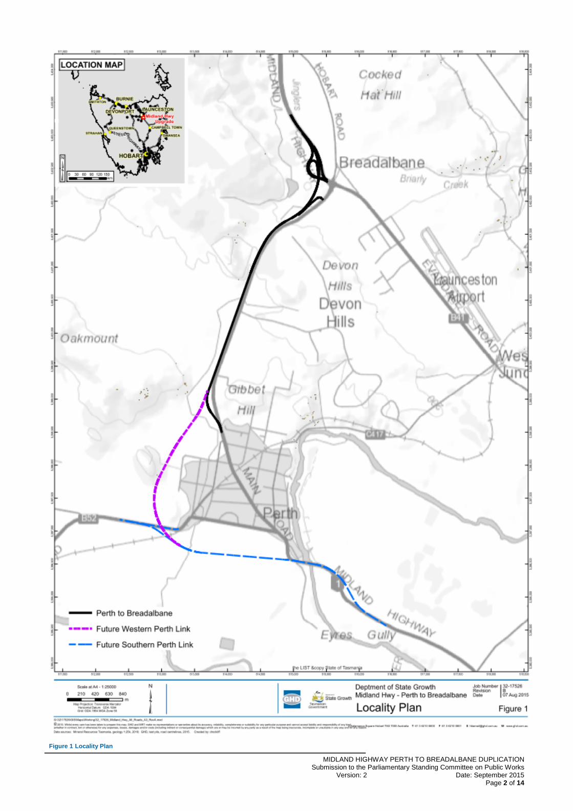
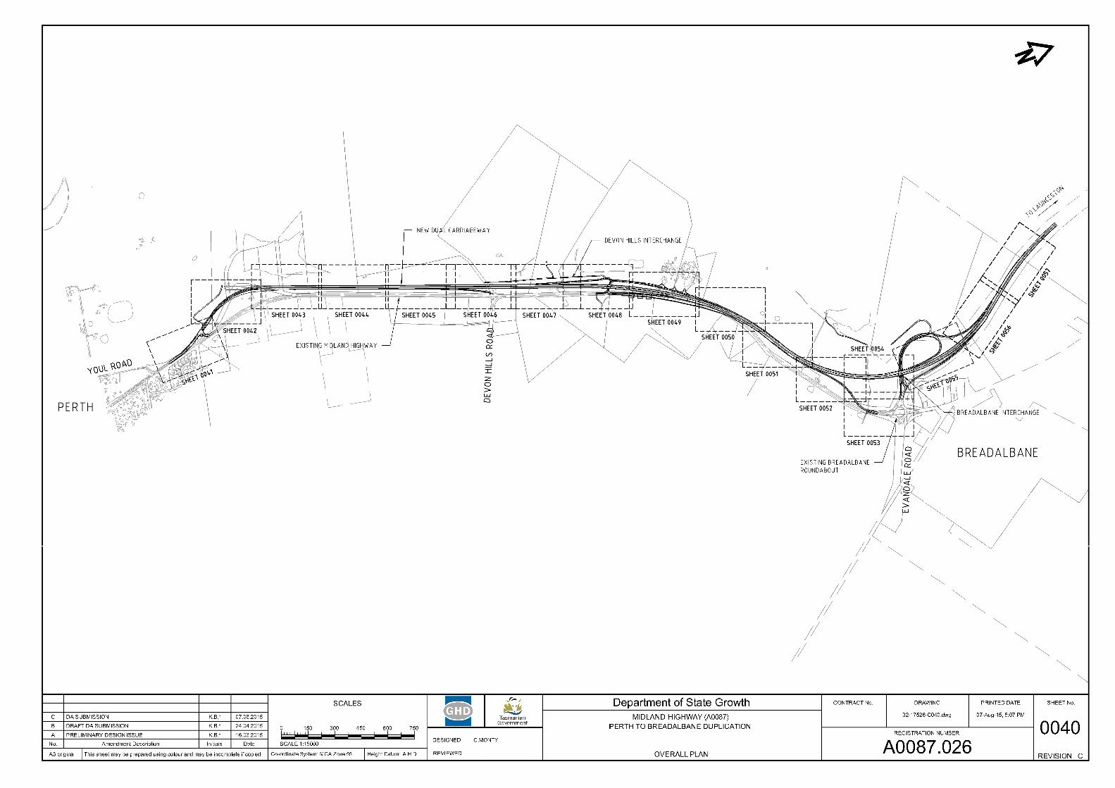
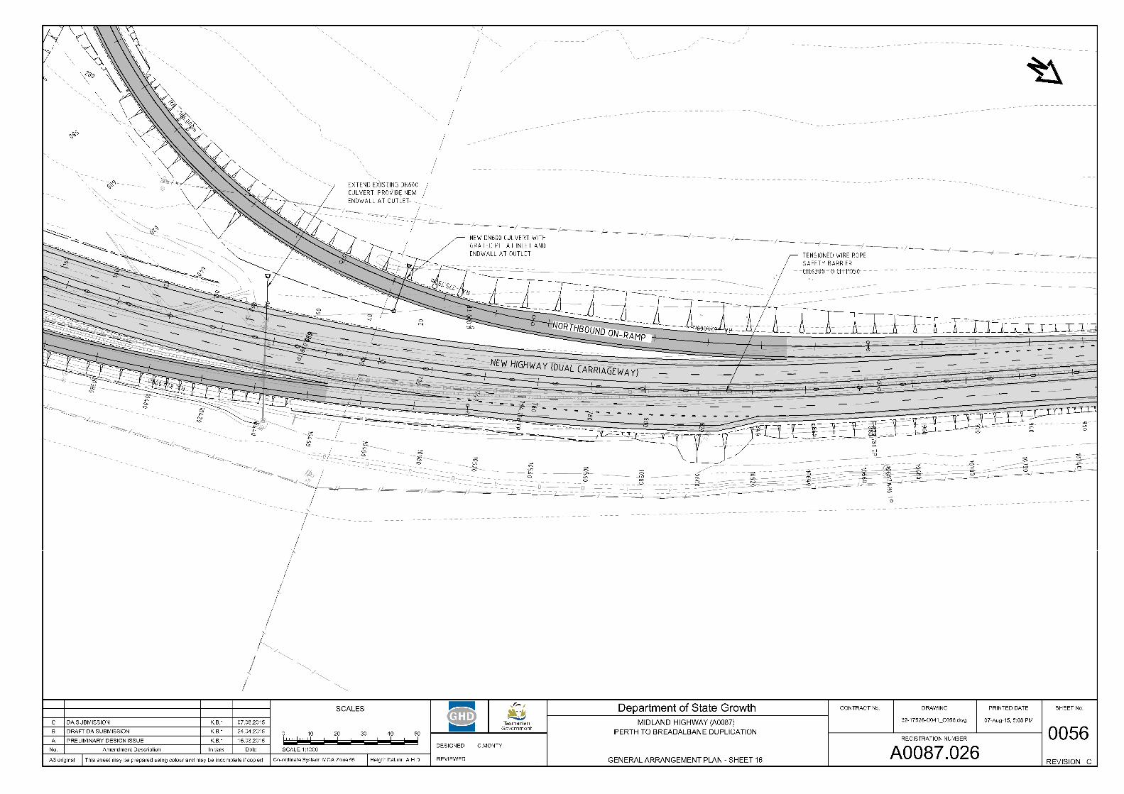
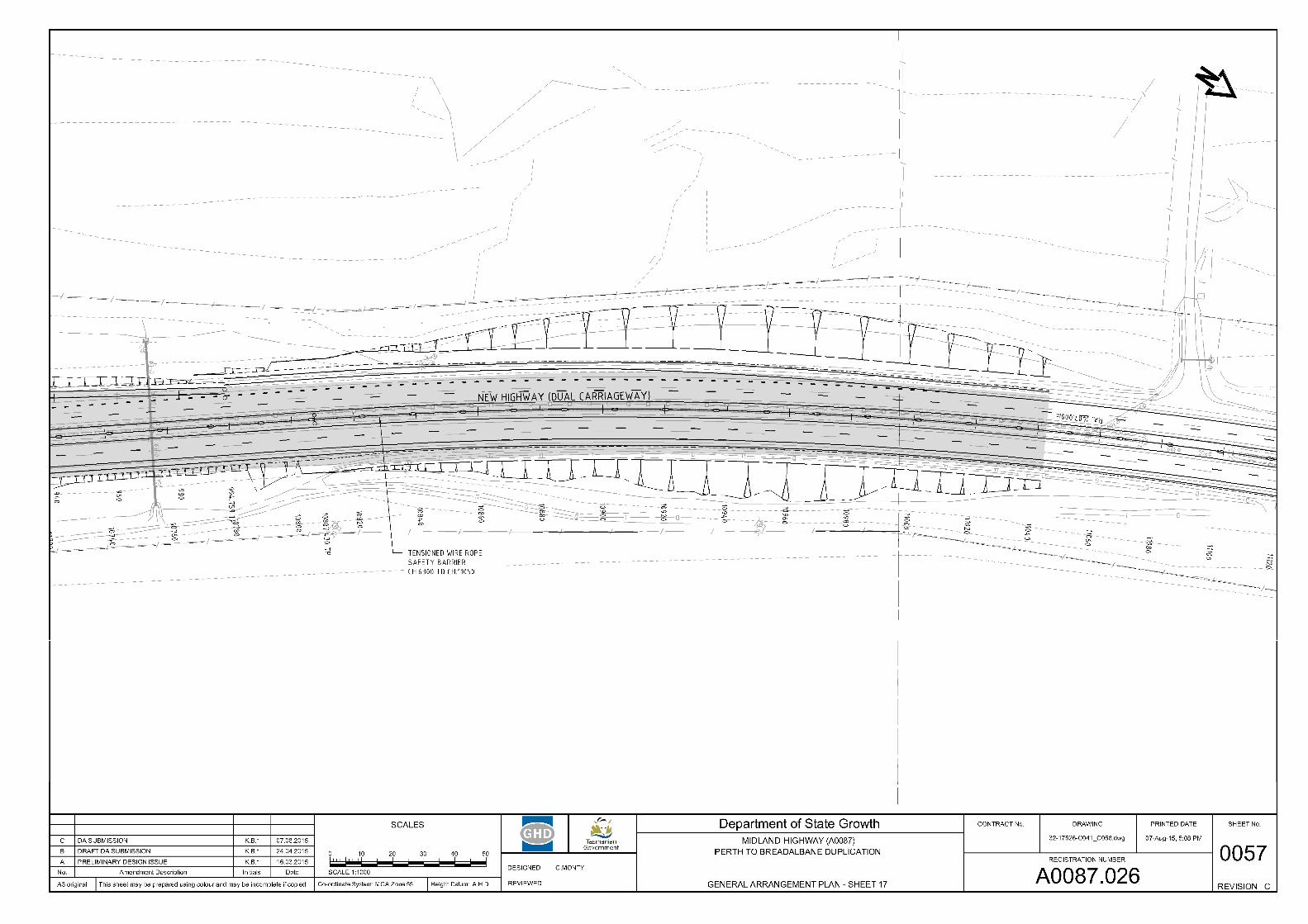
Project Location 1.3The general location and extent of the project is outlined in Figure 1 below.
MIDLAND HIGHWAY PERTH TO BREADALBANE DUPLICATION Submission to the Parliamentary Standing Committee on Public Works
Version: 2 Date: September 2015 Page 2 of 14
Figure 1 Locality Plan
MIDLAND HIGHWAY PERTH TO BREADALBANE DUPLICATION Submission to the Parliamentary Standing Committee on Public Works
Version: 2 Date: September 2015 Page 3 of 14
Strategic Context of the Project 1.4
1.4.1 Alignment with Approved Strategies The Perth-Breadalbane section of the Midland Highway carries high freight volumes and high traffic volumes relative to other sections of the Midland Highway. Continued growth in volumes through Tasmania’s three northern ports, supported by a changed direction of trade from the southern region, will impact on the land transport system. Over the past two decades, freight throughput at Hobart port has declined significantly and the southern region is now reliant on the northern ports for exports/imports.
The section of the highway between Perth and Breadalbane carried 1.3 million tonnes in 2013 and is forecast to grow to 2.3 million tonnes by 2030, to remain a high tonnage section of the north-south freight supply chain. This will see increased numbers of freight vehicles on an already constrained section of road.
Upgrading of the Midland Highway was identified as a priority by all levels of government. The project is a key component of the Midland Highway Upgrade Program 2014 and Tasmanian Infrastructure Strategy and is identified as a priority project in the Northern Integrated Transport Plan 2013 and the Midland Highway Partnership Agreement 2009.
1.4.2 Alignment with Planning Policies and Themes
The AusRAP Star Rating Australia’s National Network of Highways 2013 report found that the majority of the Midland Highway rated either only 1 or 2-star, in its 5-star safety rating scale. Specifically, the section from Perth to Breadalbane was mostly rated as 1-star.
The Midland Highway upgrade projects will use the ‘Safe System’ approach, which has been adopted by all Australian state and territory road authorities to achieve the minimum 3 star AusRAP rating. The approach recognises that people will make mistakes which result in crashes and road infrastructure needs to be designed to take account of these errors.
A number of safety treatments will be applied consistently along the Midland Highway. For the Perth to Breadalbane section, these will include:
Lane separation with flexible safety barriers, which can achieve a 90% reduction in serious road trauma caused by head-on and run-off road crashes.
Audible edge lines (rumble strips) alert drivers when they wander towards the edge of the road and provide time to recover.
Extended sealed shoulders prevent loss of control when a vehicle crosses the edge line.
Clearing roadside hazards or providing roadside barriers where hazards can’t be removed.
Improving skid resistance of road surfaces.
Limited access to new highway, except at designated interchange locations.
Grade separation at designated interchange locations.
MIDLAND HIGHWAY PERTH TO BREADALBANE DUPLICATION Submission to the Parliamentary Standing Committee on Public Works
Version: 2 Date: September 2015 Page 4 of 14
Project Details 2
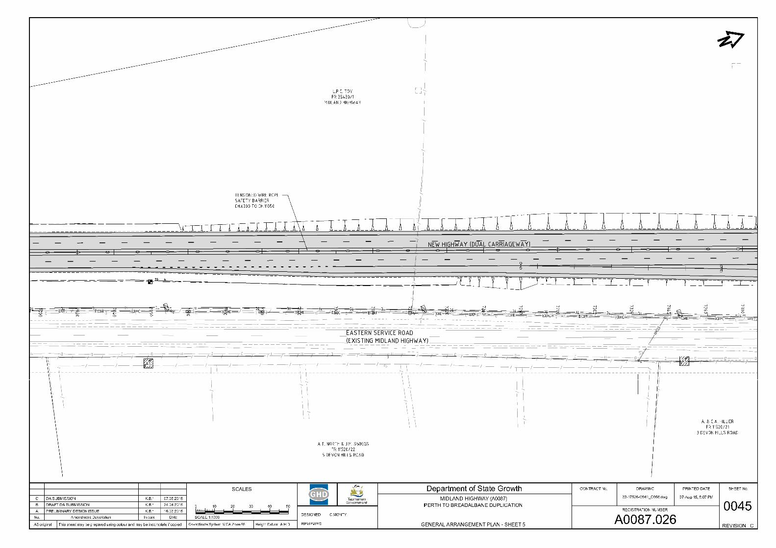
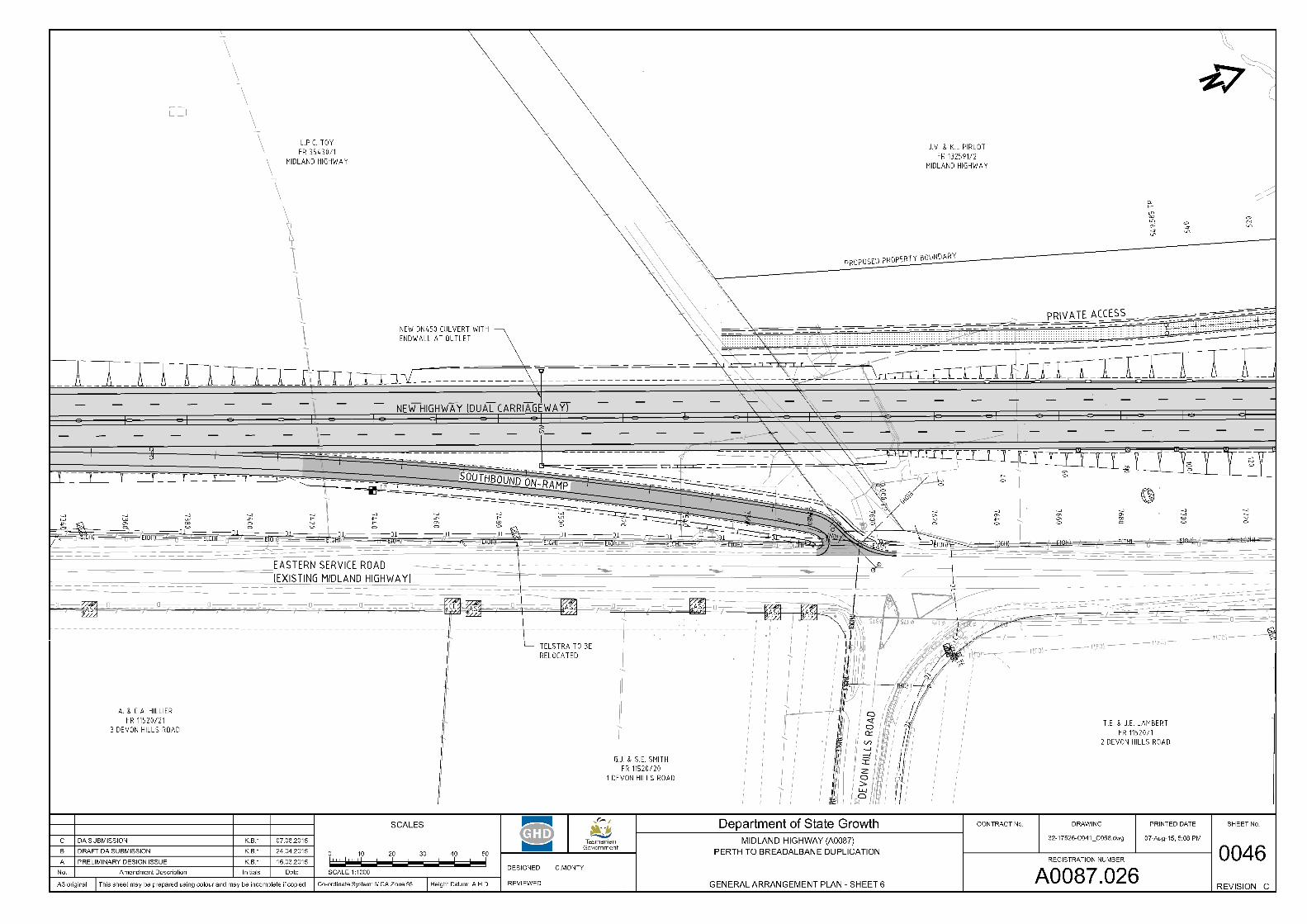
Proposed Works 2.1The project involves duplication of the existing Midland Highway between Youl Road and the Breadalbane Roundabout, and incorporates three new intersections along the new Highway.
Key features of the project include:
Two traffic lanes each way from Perth to interface with existing highway north of Breadalbane;
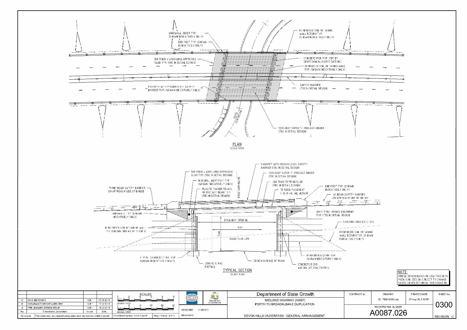
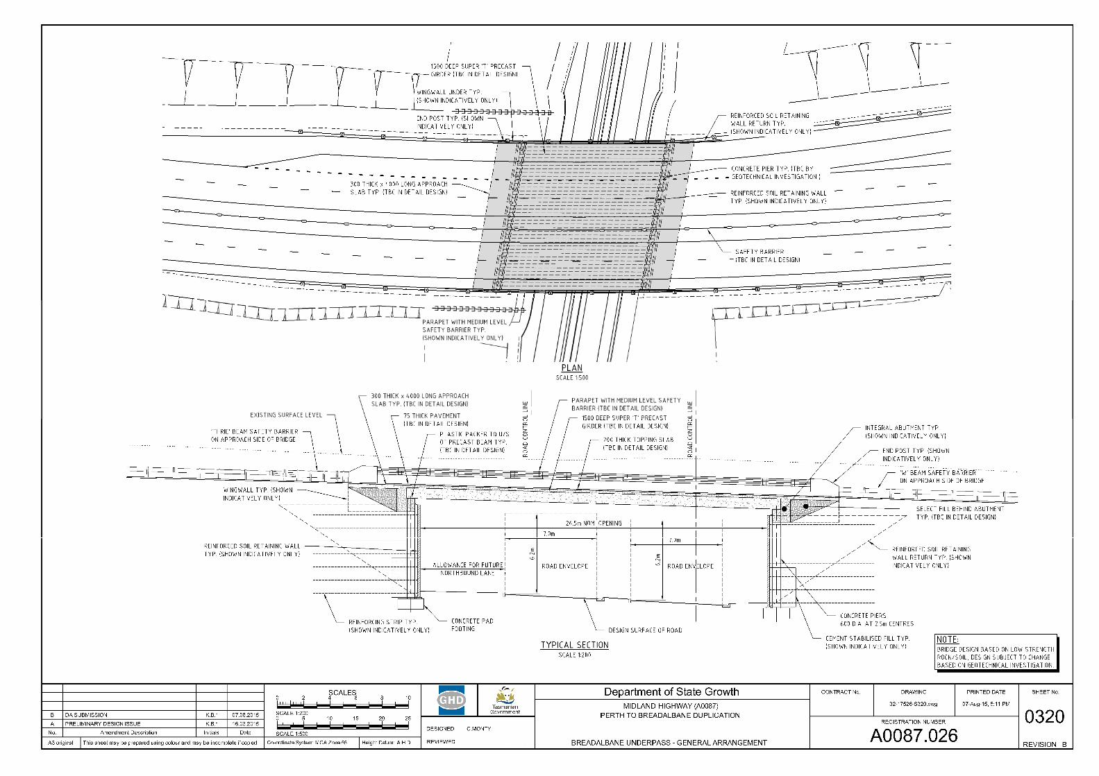
Grade-separated interchanges with Evandale Main Road and Devon Hills Road; Access to adjacent private properties along the existing Midland Highway maintained
or reconfigured; Existing highway to be converted to a new service road to facilitate local traffic
movements, property accesses, and pedestrian and cyclist movements; Total length of new road construction equivalent to approx. 24 lane-kms. Provision for extension of the highway to join with the future Perth Western Link; Acquisition of private properties (or part thereof) to facilitate the proposed
construction works; Accommodation works proposed to commence late in 2015 with significant
construction planned to commence early 2016, with a 2 year construction period expected.
Design Speed 2.2The design speed adopted for the project is 110km/h, consistent with the adjacent sections of the National Land Transport Network. It is anticipated that the posted speed will be 110km/h.
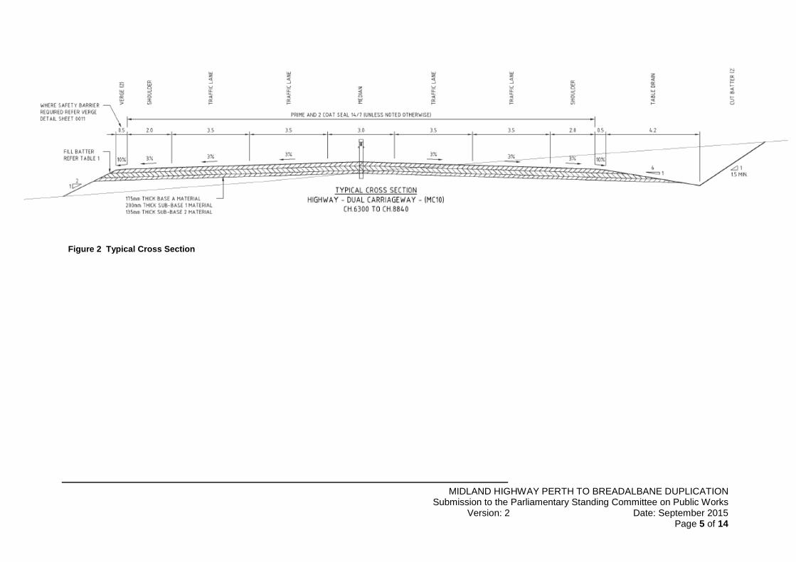
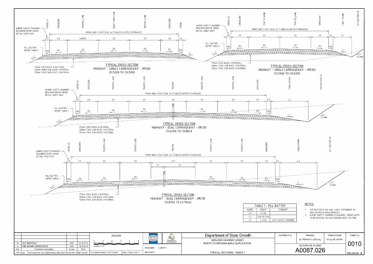
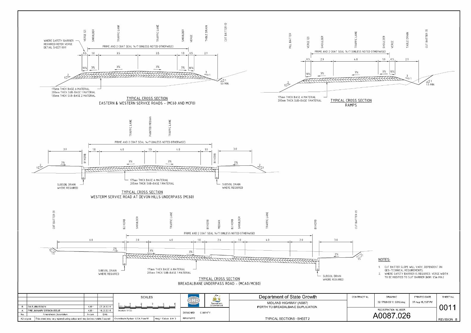
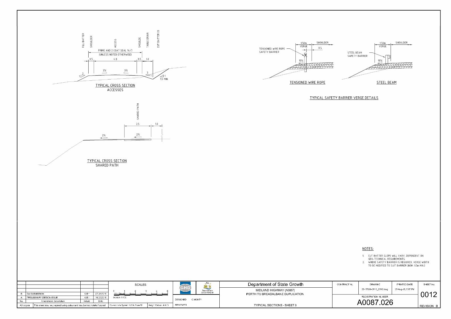
Road Cross Section 2.3The road cross section will vary between different sections of the project, such as the main highway, ramps, and service roads. The typical cross section for the main highway is indicated in Figure 2 below.
MIDLAND HIGHWAY PERTH TO BREADALBANE DUPLICATION Submission to the Parliamentary Standing Committee on Public Works
Version: 2 Date: September 2015 Page 5 of 14
Figure 2 Typical Cross Section
MIDLAND HIGHWAY PERTH TO BREADALBANE DUPLICATION Submission to the Parliamentary Standing Committee on Public Works
Version: 2 Date: September 2015 Page 6 of 14
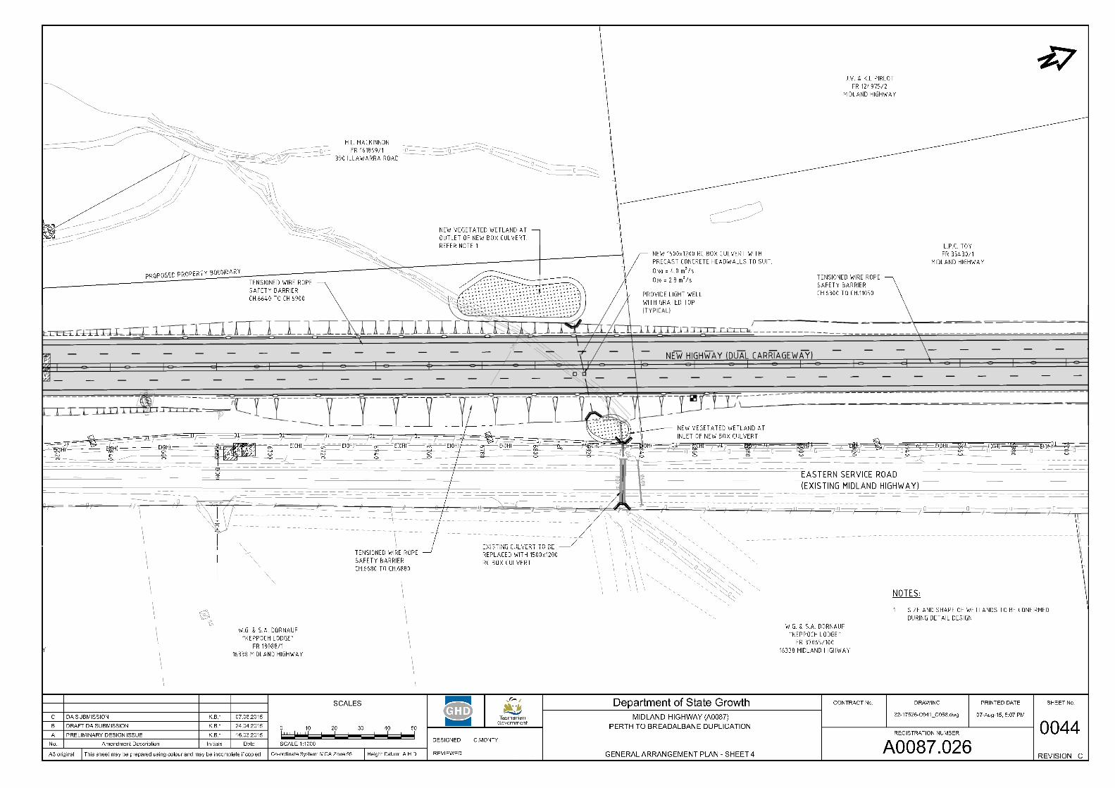
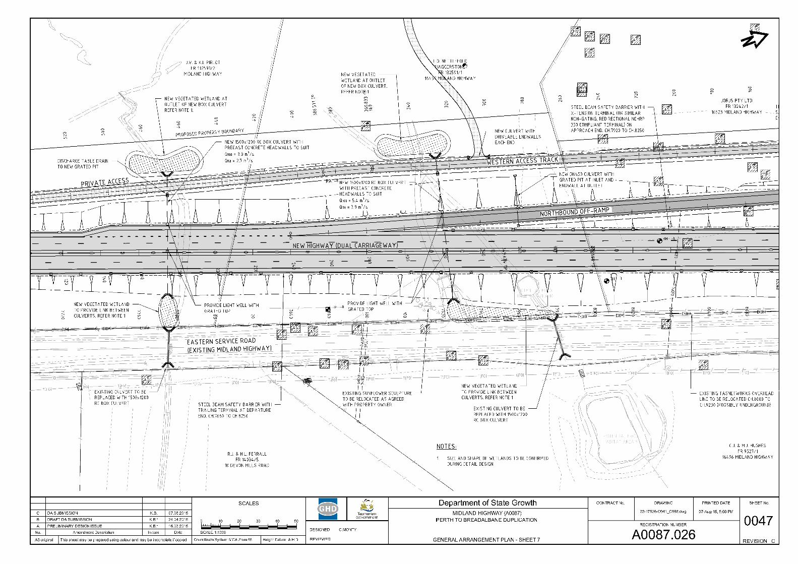
Drainage 2.4The existing highway crosses existing waterways in a number of places across the project. Stormwater drainage culverts will be installed across the highway in 5 separate locations to maintain the flow of water through these waterways. Generally, these will be located in the current waterway location or relocated in a slightly adjusted location with localised diversion of the waterway if necessary.
Where applicable, stormwater drainage from the new pavements will be directed through new culverts or more typically along the new table drains constructed at the base of the new road embankments. The stormwater drains will eventually discharge into the existing waterways.
As the new highway will intersect the existing drainage paths across the area, this had potential to affect the habitat of a nationally-listed threatened fauna species, the Green and Gold Frog (Litoria raniformis). No significant impact is expected on this species provided the new stormwater drainage culverts are designed to facilitate and where possible encourage the frogs to travel along the culverts and open drains as part of their migratory paths. Therefore, the new drainage culverts will be constructed 1200mm high x 1500mm wide, with constructed wetlands at entry and exit points to provide safe habitat for the frogs and potentially other fauna species. The Department of State Growth has issued Draft “Green and Gold Frog Management Guidelines” to outline the requirements for the design, construction, operations and maintenance phases.
Utilities 2.5
2.5.1 Overhead Power The existing overhead power lines and some support poles will need to be relocated to enable the construction to proceed. Some sections will be replaced with underground conduits due to local site conditions and constraints. The Department of State Growth is engaging with TasNetworks with regards to relocation of these services. A separate application has been submitted for the design and installation of new street lighting by TasNetworks at appropriate locations across the project.
2.5.2 Telecommunications Cables There are existing Telstra cables (including fibre-optic cable) that will be affected by the proposed highway, although a majority of the existing lines are located in private property to the east of the existing highway and as such will not be affected by the proposed highway works. Telstra cables will be relocated in conjunction with the construction contractor during the works.
2.5.3 Sewer and Water TasWater has confirmed that it has no known water and sewer assets located in the area that will be affected by the roadworks.
MIDLAND HIGHWAY PERTH TO BREADALBANE DUPLICATION Submission to the Parliamentary Standing Committee on Public Works
Version: 2 Date: September 2015 Page 7 of 14
Social, Environmental Impacts and Stakeholder 3Engagement
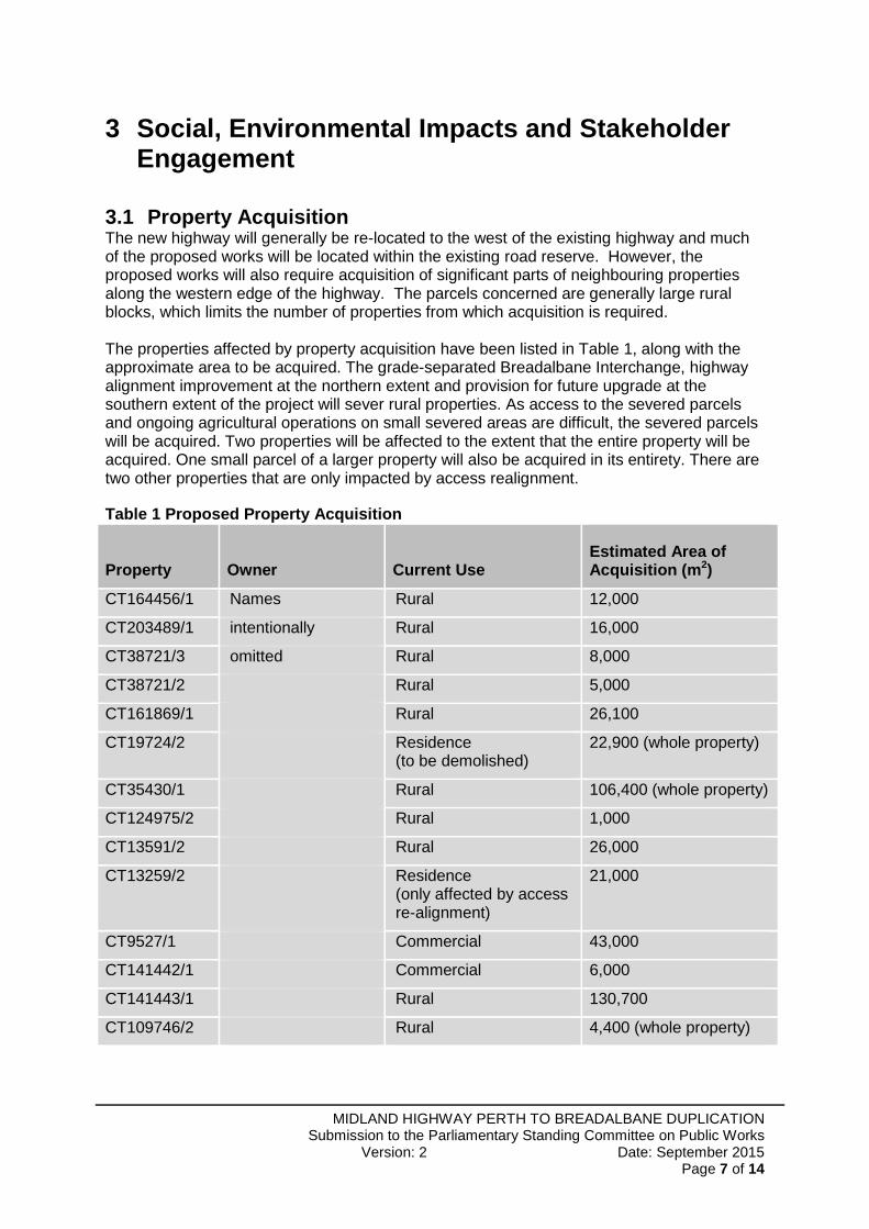
Property Acquisition 3.1The new highway will generally be re-located to the west of the existing highway and much of the proposed works will be located within the existing road reserve. However, the proposed works will also require acquisition of significant parts of neighbouring properties along the western edge of the highway. The parcels concerned are generally large rural blocks, which limits the number of properties from which acquisition is required. The properties affected by property acquisition have been listed in Table 1, along with the approximate area to be acquired. The grade-separated Breadalbane Interchange, highway alignment improvement at the northern extent and provision for future upgrade at the southern extent of the project will sever rural properties. As access to the severed parcels and ongoing agricultural operations on small severed areas are difficult, the severed parcels will be acquired. Two properties will be affected to the extent that the entire property will be acquired. One small parcel of a larger property will also be acquired in its entirety. There are two other properties that are only impacted by access realignment.
Table 1 Proposed Property Acquisition
Property Owner Current Use Estimated Area of Acquisition (m2)
CT164456/1 Names Rural 12,000
CT203489/1 intentionally Rural 16,000
CT38721/3 omitted Rural 8,000
CT38721/2 Rural 5,000
CT161869/1 Rural 26,100
CT19724/2 Residence (to be demolished)
22,900 (whole property)
CT35430/1 Rural 106,400 (whole property)
CT124975/2 Rural 1,000
CT13591/2 Rural 26,000
CT13259/2 Residence (only affected by access re-alignment)
21,000
CT9527/1 Commercial 43,000
CT141442/1 Commercial 6,000
CT141443/1 Rural 130,700
CT109746/2 Rural 4,400 (whole property)
MIDLAND HIGHWAY PERTH TO BREADALBANE DUPLICATION Submission to the Parliamentary Standing Committee on Public Works
Version: 2 Date: September 2015 Page 8 of 14
Noise 3.2Noise modelling and proposed mitigation has been performed in accordance with State Growth Traffic Noise Management guidelines. The assessment consisted of noise monitoring at selected sites throughout the area to measure existing noise levels and calibrate a model of the predicted traffic noise. The predicted noise levels were calculated for the future traffic flows and the proposed road design and assessed against the acceptable limits outlined in the guidelines.
An outcome of this modelling was that only a small number of properties were found to satisfy the threshold at which noise mitigation would be considered. Another was that the most appropriate and cost-effective solution for these properties would be individual residence improvements, such as glazing treatments, negotiated directly with the landowners.
It is also worth noting that many properties in the area will experience a reduction in existing noise levels due to relocation of the highway further to the west away from neighbouring residential properties. For the few houses that require mitigation for increased traffic noise levels, these elevated levels are likely to reduce significantly once the Perth Western Link project is constructed.
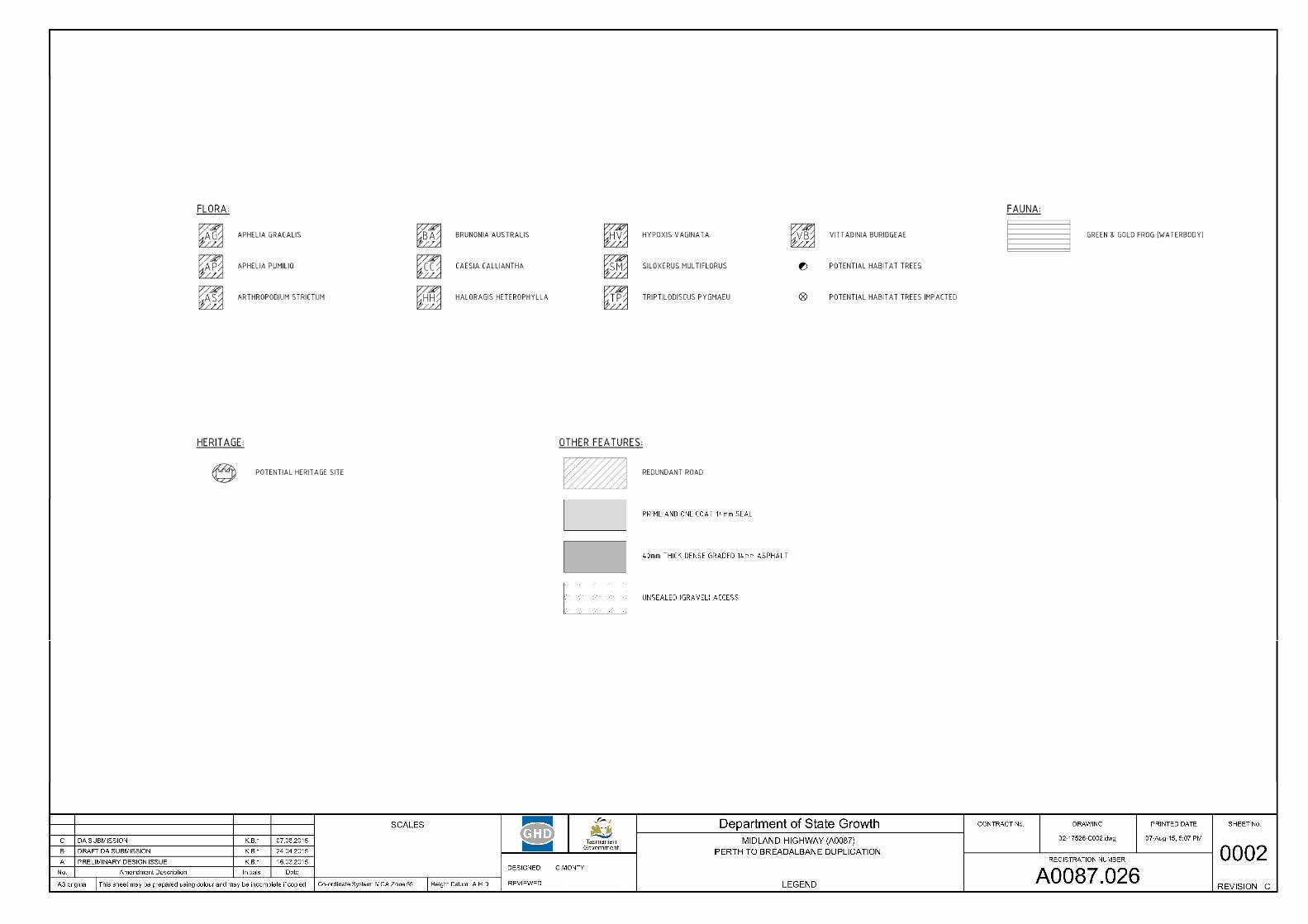
Flora 3.3Eleven state listed threatened vegetation species have been identified within the study area. The location of the species has been overlaid on the design to determine the impact prior to any submission. An Application for a Permit to Take Threatened Flora has been submitted to DPIPWE where State-listed threatened flora species are affected.
No significant potential impacts to Commonwealth listed flora species were identified.
Fauna 3.4The site includes a number of significant Eucalyptus trees, including some that are considered to be potential habitat for the Tasmanian Masked Owl (Tyto novaehollandiae castanops), which is a Commonwealth-listed threatened species. A thorough survey of existing trees that would be suitable as potential Masked Owl habitat has been completed. Where possible, the design has avoided the identified habitat trees to minimise the potential impact. Where potential habitat trees cannot be avoided, additional field surveys have been conducted to ascertain whether the tree is indeed providing habitat for any Masked Owls. This will allow the project team to take the necessary actions to minimise future potential impact of the highway construction.
As the route of the highway is within an identified Green and Gold Frog (Litoria raniformis) habitat zone, the project will apply the Department of State Growth’s Green and Gold Frog Management Guidelines. Adherence to these Guidelines means that the design, construction and subsequent maintenance activities will be performed to best practice standards to ensure the minimum disruption to the frogs and limit any potential impacts. The Guidelines require large stormwater culverts to be constructed along existing waterways, as these are generally the frog migratory pathways. The culverts will have constructed wetlands at each end and shafts will be constructed to allow natural ventilation and lighting to enter the culvert. These steps will encourage the migration of the frogs along their existing routes rather than venturing over the pavement when crossing the highway.
The stormwater culverts will have both a wet section and a dry section that will also allow other fauna to utilise the crossing if desired.
MIDLAND HIGHWAY PERTH TO BREADALBANE DUPLICATION Submission to the Parliamentary Standing Committee on Public Works
Version: 2 Date: September 2015 Page 9 of 14
Aboriginal Heritage 3.5An Aboriginal Heritage Survey of the study area was undertaken by Cultural Heritage Management Australia (CHMA) in December 2013. One Aboriginal heritage site, listed on the TASI register, was identified during the field assessment. This site is classified as an isolated artefact, situated on an existing graded vehicle track. In addition to the known site, one Potential Archaeological Deposit (PAD) was identified from predictive modelling of the study area.
While the proposed highway footprint does cross the PAD area, the registered TASI site will not be impacted upon by the proposed works. Permits will not be required under the Aboriginal Relics Act 1975.
Notwithstanding this, all Aboriginal heritage is protected under the Aboriginal Relics Act 1975, and therefore an Unanticipated Discovery Plan will be developed and implemented in the works process to assist in meeting the requirements under the Act should Aboriginal heritage be uncovered.
Historic Heritage Assessment 3.6The 2014 heritage assessment identified two properties in the area, Haggerston and Rathmolyn, which are listed on the Tasmanian Heritage Register. The assessment also identified 5 other historic sites comprising 3 possible building foundations likely to be part of a single site complex, an old track and a planting of Macrocarpa trees with associated buildings.
The proposed works will have no impact on the Rathmolyn property.
The proposed works will impact only on the eastern boundary of the Haggerston property and do not impact on the items of heritage significance within this property. Works will involve replacing fencing, gates and access tracks, which are not considered to be of heritage value. Approval from Heritage Tasmania is not required, but Northern Midlands Council may apply conditions in relation to historic heritage in the project Development Permit.
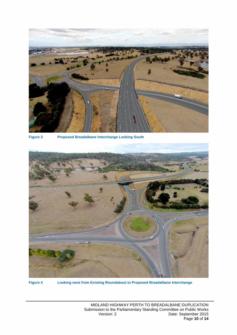
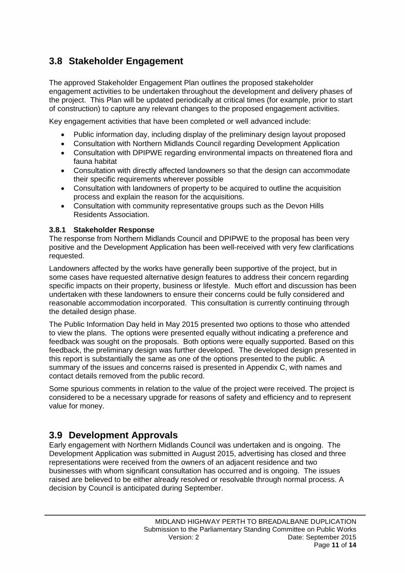
Landscape and Visual Impacts 3.7As the alignment is close to the original highway and the landscape is generally flat terrain with rolling hills with some trees and shrubs, the overall visual impact on the landscape will be limited. Parts of the alignment will have a relatively large amount of fill material to be placed to raise the existing ground level to the finished road surface level. The visual impact of high embankments was considered throughout the design and minimised wherever possible. Specific consultation with stakeholders who are adversely affected by the visual impacts of the altered landscape are part of ongoing discussions.
To improve effective and accurate presentation of the proposed design, a series of photo-realistic images were created from still photos of the site at critical locations combined with the design road model at that time. These photos were presented at the public information day and then included in the Development Application report.
Examples of these images are provided below:
MIDLAND HIGHWAY PERTH TO BREADALBANE DUPLICATION Submission to the Parliamentary Standing Committee on Public Works
Version: 2 Date: September 2015 Page 10 of 14
Figure 3 Proposed Breadalbane Interchange Looking South
Figure 4 Looking west from Existing Roundabout to Proposed Breadalbane Interchange
MIDLAND HIGHWAY PERTH TO BREADALBANE DUPLICATION Submission to the Parliamentary Standing Committee on Public Works
Version: 2 Date: September 2015 Page 11 of 14
Stakeholder Engagement 3.8
The approved Stakeholder Engagement Plan outlines the proposed stakeholder engagement activities to be undertaken throughout the development and delivery phases of the project. This Plan will be updated periodically at critical times (for example, prior to start of construction) to capture any relevant changes to the proposed engagement activities.
Key engagement activities that have been completed or well advanced include:
Public information day, including display of the preliminary design layout proposed Consultation with Northern Midlands Council regarding Development Application Consultation with DPIPWE regarding environmental impacts on threatened flora and
fauna habitat Consultation with directly affected landowners so that the design can accommodate
their specific requirements wherever possible Consultation with landowners of property to be acquired to outline the acquisition
process and explain the reason for the acquisitions. Consultation with community representative groups such as the Devon Hills
Residents Association.
3.8.1 Stakeholder Response The response from Northern Midlands Council and DPIPWE to the proposal has been very positive and the Development Application has been well-received with very few clarifications requested.
Landowners affected by the works have generally been supportive of the project, but in some cases have requested alternative design features to address their concern regarding specific impacts on their property, business or lifestyle. Much effort and discussion has been undertaken with these landowners to ensure their concerns could be fully considered and reasonable accommodation incorporated. This consultation is currently continuing through the detailed design phase.
The Public Information Day held in May 2015 presented two options to those who attended to view the plans. The options were presented equally without indicating a preference and feedback was sought on the proposals. Both options were equally supported. Based on this feedback, the preliminary design was further developed. The developed design presented in this report is substantially the same as one of the options presented to the public. A summary of the issues and concerns raised is presented in Appendix C, with names and contact details removed from the public record.
Some spurious comments in relation to the value of the project were received. The project is considered to be a necessary upgrade for reasons of safety and efficiency and to represent value for money.
Development Approvals 3.9Early engagement with Northern Midlands Council was undertaken and is ongoing. The Development Application was submitted in August 2015, advertising has closed and three representations were received from the owners of an adjacent residence and two businesses with whom significant consultation has occurred and is ongoing. The issues raised are believed to be either already resolved or resolvable through normal process. A decision by Council is anticipated during September.
MIDLAND HIGHWAY PERTH TO BREADALBANE DUPLICATION Submission to the Parliamentary Standing Committee on Public Works
Version: 2 Date: September 2015 Page 12 of 14
Project Program and Costs 4
Project Program 4.1The current delivery program for the project is based on achievement of the following key milestones:
Table 2 Expected Delivery Program Milestones
Milestone Completion Date Critical Path or Potentially Critical
Preliminary Design Approval July 2015
(achieved) Yes
Parliamentary Standing Committee on Public Works
September 2015 Potential
Local Government Development Application Approval
October 2015 Potential
Detail Design Approval October 2015 Yes
Tender Advertised October 2015 Yes
Contract Awarded December 2015 Yes
Practical Completion (subject to contractor’s proposed construction program)
March 2018 No
Costs 4.2
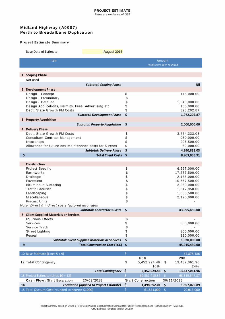
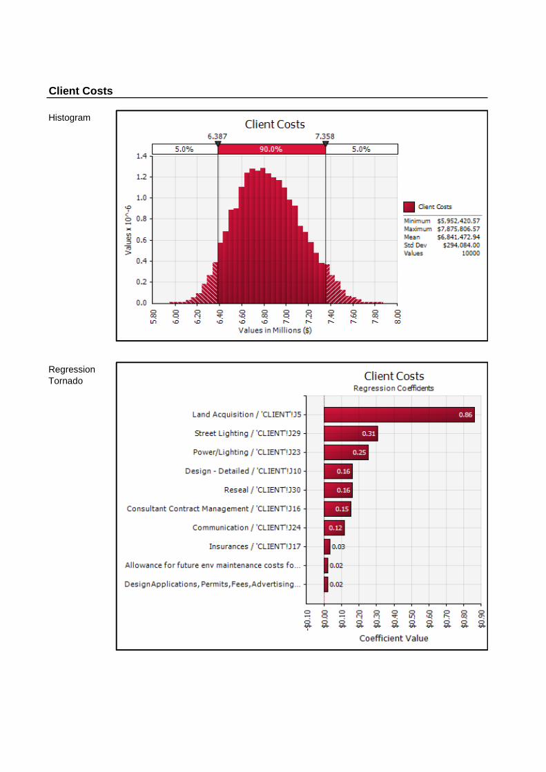
A detailed estimate of the expected out-turn costs has been produced for the project, including probabilistic methods using a Monte Carlo analysis of inherent and contingent risk factors that have been identified by the wider project team, as outlined in the Best Practice Cost Estimation Guidelines (State Growth, 2013).
A high level summary of the cost estimate is outlined in Table 3 below and additional information is provided in Appendix B.
MIDLAND HIGHWAY PERTH TO BREADALBANE DUPLICATION Submission to the Parliamentary Standing Committee on Public Works
Version: 2 Date: September 2015 Page 13 of 14
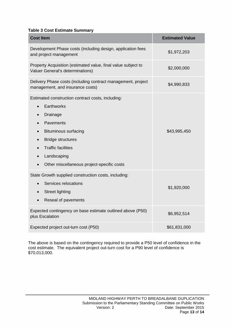
Table 3 Cost Estimate Summary
Cost Item Estimated Value
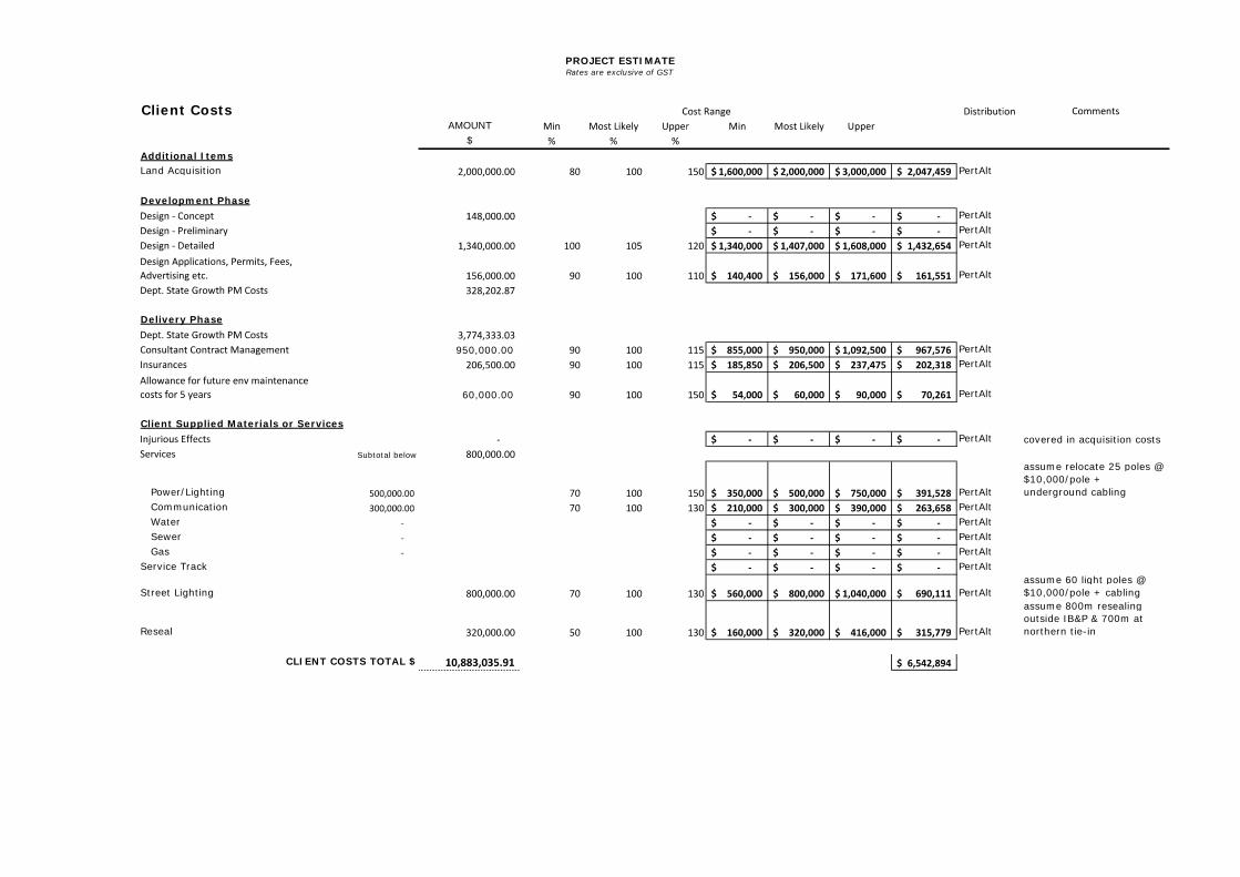
Development Phase costs (including design, application fees and project management
$1,972,203
Property Acquisition (estimated value, final value subject to Valuer General’s determinations)
$2,000,000
Delivery Phase costs (including contract management, project management, and insurance costs)
$4,990,833
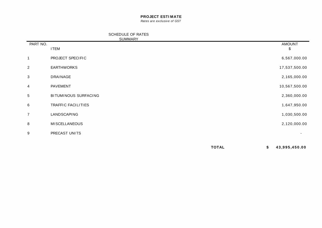
Estimated construction contract costs, including:
Earthworks
Drainage
Pavements
Bituminous surfacing
Bridge structures
Traffic facilities
Landscaping
Other miscellaneous project-specific costs
$43,995,450
State Growth supplied construction costs, including:
Services relocations
Street lighting
Reseal of pavements
$1,920,000
Expected contingency on base estimate outlined above (P50) plus Escalation
$6,952,514
Expected project out-turn cost (P50) $61,831,000
The above is based on the contingency required to provide a P50 level of confidence in the cost estimate. The equivalent project out-turn cost for a P90 level of confidence is $70,013,000.
MIDLAND HIGHWAY PERTH TO BREADALBANE DUPLICATION Submission to the Parliamentary Standing Committee on Public Works
Version: 2 Date: September 2015 Page 14 of 14
Conclusion 5
The design for the proposed reconstruction of the section of the Midland Highway between Perth and Breadalbane has been carried out in accordance with the appropriate design standards and guidelines and in consultation with relevant stakeholders. The input and requests of adjoining landowners, Northern Midlands Council and public utility owners have been fully considered and reasonable accommodation incorporated where practicable.
Once complete, the works will provide improved safety by providing;
A consistent high speed dual lane road environment from Launceston to Perth with 2 lanes in each direction with wider pavements and sealed shoulders;
The elimination of head on collisions through the use of a central flexible safety barrier;
Provision of new dedicated interchanges that allow for the removal of all accesses from the highway and eliminate dangerous ‘at grade’ turning movements;
Audible edge lines; Improved sight distances.
The completed works will support transport efficiency and safety objectives on the National Land Transport Network by providing additional traffic lanes and better connections with adjacent roads and properties.
It is recommended the project be approved.
Submission to the ParliamentaryStanding Committee on Public Works
Appendix A. Drawings
Submission to the ParliamentaryStanding Committee on Public Works
Appendix B. P50 / P 90 Cost Estimates
PROJECT ESTIMATERates are exclusive of GST
OPTION 1B
Project Estimate Summary
Design - ConceptDesign - PreliminaryDesign - DetailedDesign Applications, Permits, Fees, Advertising etc.Dept. State Growth PM Costs
Dept. State Growth PM CostsConsultant Contract ManagementInsurancesAllowance for future env maintenance costs for 5 years
Project SpecificEarthworksDrainagePavementBituminous SurfacingTraffic FacilitiesLandscapingMiscellaneousPrecast Units
Note: Direct & indirect costs factored into rates
Injurious EffectsServicesService TrackStreet LightingReseal
P50 P9012 Total Contingency 5,452,924.46$ 13,437,061.96$
10% 24%
Cash Flow: Start Escalation 20/03/2015 Start Construction 30/11/2015
Midland Highway (A0087)Perth to Breadalbane Duplication
148,000.00$
328,202.87$
-$ 1,340,000.00$
156,000.00$
6,567,000.00$
3,774,333.03$ 950,000.00$ 206,500.00$
2,120,000.00$ -$
60,000.00$
17,537,500.00$ 2,165,000.00$
10,567,500.00$ 2,360,000.00$ 1,647,950.00$ 1,030,500.00$
800,000.00$ -$
-$
320,000.00$ 800,000.00$
Project Summary based on Evans & Peck 'Best Practice Cost Estimation Standard for Publicly Funded Road and Rail Construction' - May 2011GHD Estimate Template Version 2012.04
PROJECT ESTIMATERates are exclusive of GST
SCHEDULE OF RATESSUMMARY
PART NO. AMOUNTITEM $
1 6,567,000.00
2 17,537,500.00
3 2,165,000.00
4 10,567,500.00
5 2,360,000.00
6 1,647,950.00
7 1,030,500.00
8 2,120,000.00
9 -
TOTAL $ 43,995,450.00
PRECAST UNITS
PROJECT SPECIFIC
EARTHWORKS
DRAINAGE
PAVEMENT
BITUMINOUS SURFACING
TRAFFIC FACILITIES
LANDSCAPING
MISCELLANEOUS
PROJECT ESTIMATERates are exclusive of GST
Client CostsAMOUNT
$Additional ItemsLand Acquisition PertAlt
Development PhasePertAltPertAltPertAlt
PertAlt
Delivery Phase
950,000.00 PertAltPertAlt
60,000.00 PertAlt
- PertAlt covered in acquisition costsSubtotal below
Power/Lighting PertAlt
assume relocate 25 poles @ $10,000/pole + underground cabling
Communication PertAlt Water PertAlt Sewer PertAlt Gas PertAltService Track PertAlt
Street Lighting PertAltassume 60 light poles @ $10,000/pole + cabling
Reseal PertAlt
assume 800m resealing outside IB&P & 700m at northern tie-in
CLIENT COSTS TOTAL $
Client Supplied Materials or Services

Contingent RiskSeverity of Occurance
Distribution
$ Description $ Description $ Description
Representations against the Development Application delay commencement of construction 10% 1 920,000 2,300,000 4,600,000 LogNormalAltPotential for trigger to EPBC referral, thereby delaying the commencement of construction 5% 1 920,000 2,300,000 4,600,000 LogNormalAlt
Discovery of heritage items during construction 5% 1 230,000 2,300,000 4,600,000 LogNormalAlt
Stakeholders change scope 5% 1 210,000 420,000 840,000 LogNormalAltConstruction staging has not been developed and may impact on cost estimate 5% 1 210,000 420,000 840,000 LogNormalAltInclement weather greater than envisaged delays delivery of project (prolongation of project) 10% 1 230,000 460,000 920,000 LogNormalAlt
Discovery of additional services not shown 10% 1 460,000 920,000 2,300,000 LogNormalAltShortage of key components due to lack of local manufacture (steel, bitumen etc) 5% 1 230,000 920,000 2,300,000 LogNormalAltUnexpected geotechnical conditions encountered during construction 10% 1 2,300,000 4,600,000 9,200,000 LogNormalAlt
A safety incident disrupts the program 5% 1 460,000 1,380,000 2,300,000 PertAlt
Public utility owners cause delays during construction 15% 1 460,000 1,380,000 2,300,000 PertAlt
Construction industry capacity impacts on project costs 15% 1 840,000 2,100,000 4,200,000 LogNormalAlt
Construction impacts on adjacent businesses (IBP/Digga) 10% 1 400,000 1,000,000 2,000,000 LogNormalAltCondensed timeframe for design leads to omissions and extra costs / delays 20% 1 230,000 460,000 920,000 LogNormalAltLump Sum contract increases costs compared to historical SOR costs 20% 1 460,000 920,000 2,300,000 LogNormalAltProperty Acquisition compensation costs continue beyond construction period and exceed estimates 10% 1 200,000 500,000 1,000,000 LogNormalAlt
Unidentified RisksAccommodation of smaller risks not specifically identified in the risk register 100,000 200,000 300,000 PertAlt
Optimistic Most Likely Pessimistic
Description
Average Frequency of Occurrence
(%)
Estimated No. Occurances Comment
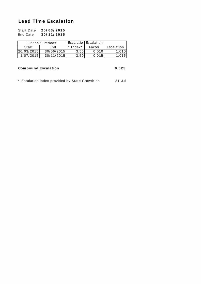
Start Date 20/03/2015End Date 30/11/2015
Start End20/03/2015 30/06/2015 3.50 0.010 1.0101/07/2015 30/11/2015 3.50 0.015 1.015
0.025
31-Jul
Lead Time Escalation
* Escalation index provided by State Growth on
Compound Escalation
EscalationFinancial Periods Escalatio
n Index*Escalation
Factor
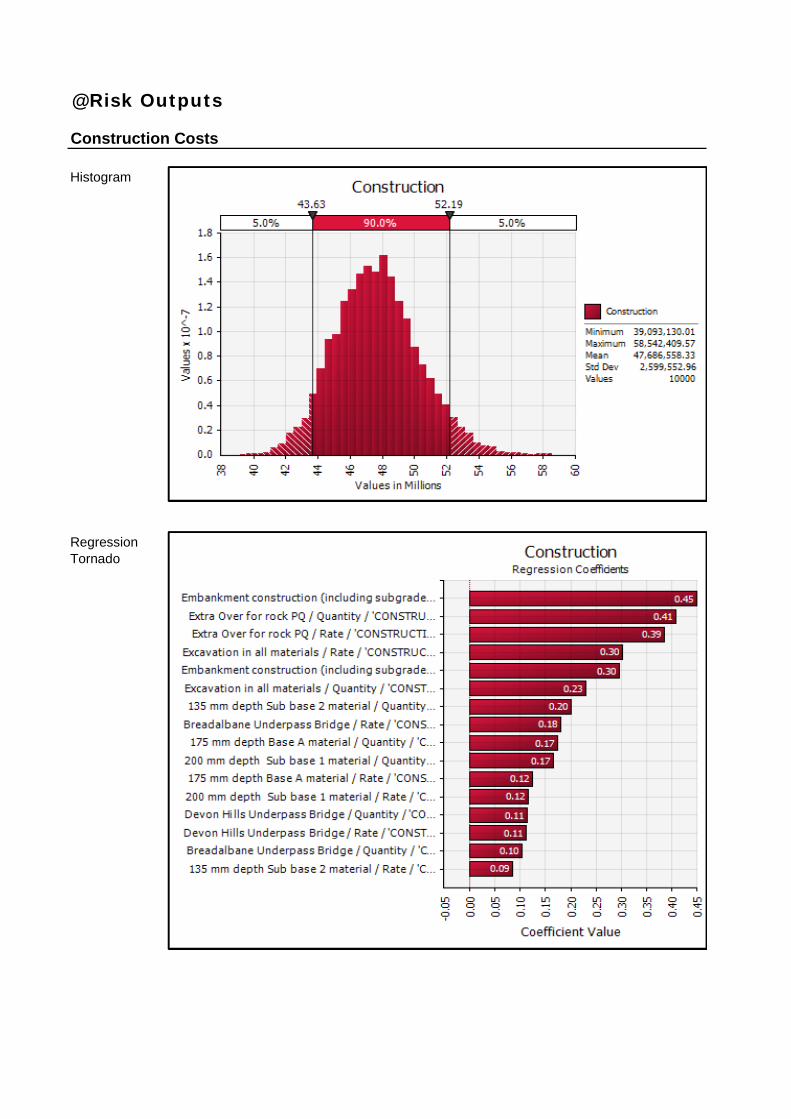
Histogram
@Risk Outputs
Construction Costs
Regression Tornado
Histogram
Client Costs
Regression Tornado
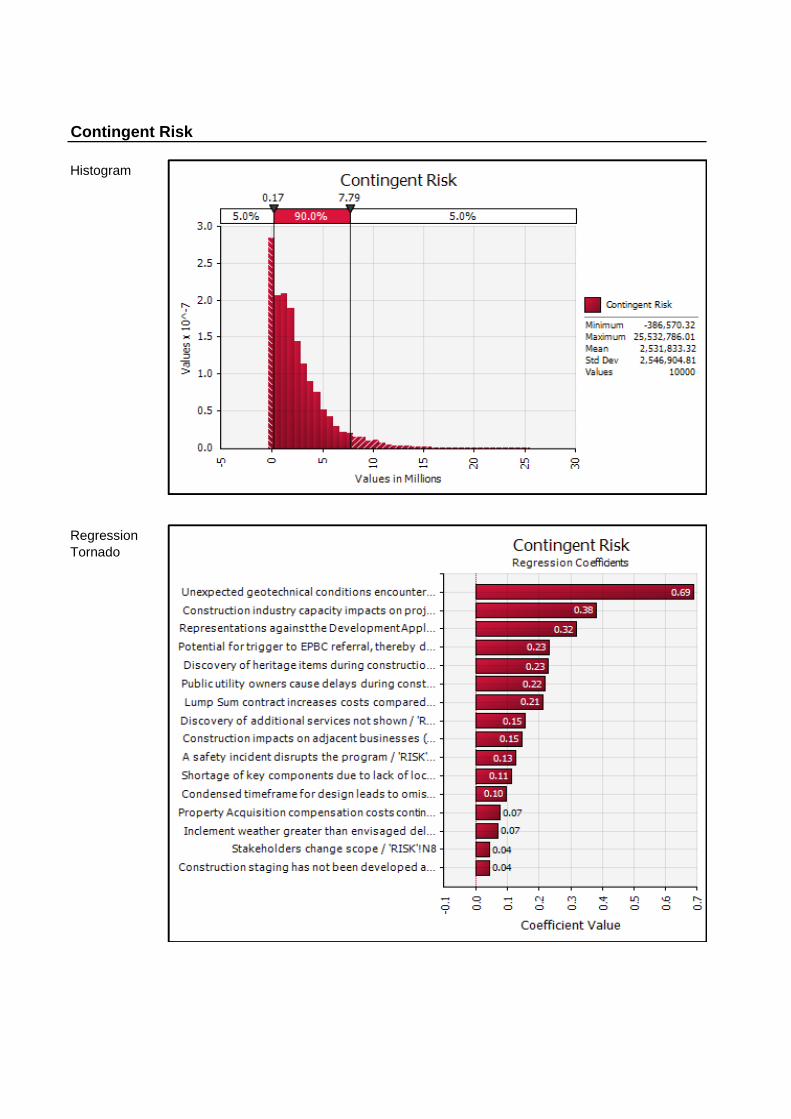
Histogram
Contingent Risk
Regression Tornado
Submission to the ParliamentaryStanding Committee on Public Works
Appendix C. Stakeholder Concerns
1
REPORT ON RESPONSES – PUBLIC DISPLAY
Midland Highway – Perth to Breadalbane Duplication
Friday 1 May and Saturday 2 May 2015
Public Display Details
The proposed options for the Midland Highway – Perth to Breadalbane Duplication were put on display on Friday 1 May 2015 (6.45pm to 7.45pm) at Devon Hills Fire Station and Saturday 2 May 2015 (10am to 2pm) at the Perth Community Hall.
The options put on display were as follows:
Option 1: Underpass to western side and shared path from Devon Hills to Breadalbane roundabout.
Option 2: Retain existing highway as local road adjacent to the highway for the full extent - Perth to Breadalbane with and overpass at Island Block and Paving (and Digga Constructions) to provide access to the western side.
The Devon Hills session was conducted based on an invitation by NMC Councillor Janet Lambert on behalf of the Devon Hill Community Association.
A presentation was delivered by Damion Beety and Graeme Nibbs at the Devon Hills Fire Station session and a number of questions answered.
The Friday session was attended by Damion Beety (Project Manager), Graeme Nibbs (Stakeholder Engagement Unit (SEU) Manager), Amanda Keygan (Project Office SEU) and Vili Siale (Project Management Support).
The Saturday session was attended by Damion Beety (Project Manager), Graeme Nibbs (SEU Manager), Amanda Keygan (Project Office SEU) and Graeme Edwards (Senior Engineer GHD)
Response boxes were provided at both sessions and feedback encouraged by Friday 8 May 2015.
The display has also been put on Display at the Northern Midlands Council for a period of one month from 4 May 2015 to the end of May. The contact information will not be included in this informational display to avoid confusion with the Development Application process which is likely to run during this period.
The sessions were widely advertised including:
Letter to adjacent residents advising of the display;
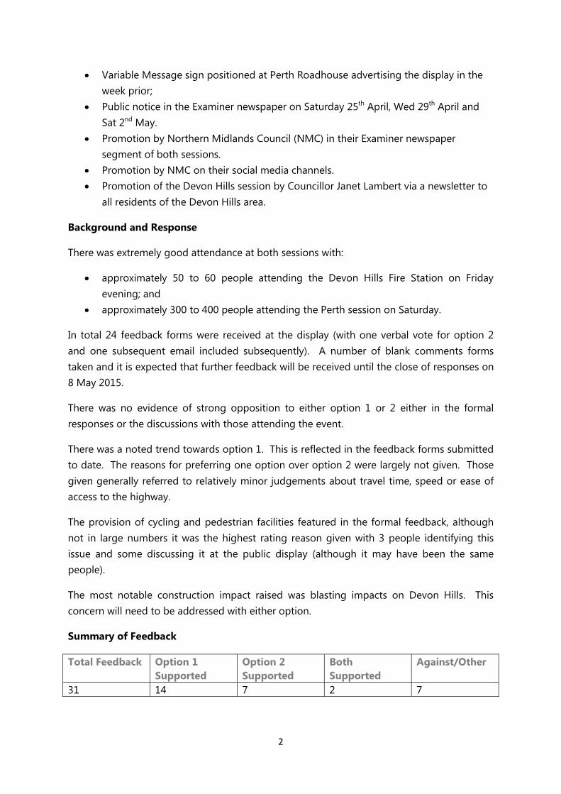
2
Variable Message sign positioned at Perth Roadhouse advertising the display in the week prior;
Public notice in the Examiner newspaper on Saturday 25th April, Wed 29th April and Sat 2nd May.
Promotion by Northern Midlands Council (NMC) in their Examiner newspaper segment of both sessions.
Promotion by NMC on their social media channels. Promotion of the Devon Hills session by Councillor Janet Lambert via a newsletter to
all residents of the Devon Hills area.
Background and Response
There was extremely good attendance at both sessions with:
approximately 50 to 60 people attending the Devon Hills Fire Station on Friday evening; and
approximately 300 to 400 people attending the Perth session on Saturday.
In total 24 feedback forms were received at the display (with one verbal vote for option 2 and one subsequent email included subsequently). A number of blank comments forms taken and it is expected that further feedback will be received until the close of responses on 8 May 2015.
There was no evidence of strong opposition to either option 1 or 2 either in the formal responses or the discussions with those attending the event.
There was a noted trend towards option 1. This is reflected in the feedback forms submitted to date. The reasons for preferring one option over option 2 were largely not given. Those given generally referred to relatively minor judgements about travel time, speed or ease of access to the highway.
The provision of cycling and pedestrian facilities featured in the formal feedback, although not in large numbers it was the highest rating reason given with 3 people identifying this issue and some discussing it at the public display (although it may have been the same people).
The most notable construction impact raised was blasting impacts on Devon Hills. This concern will need to be addressed with either option.
Summary of Feedback
Total Feedback Option 1 Supported
Option 2 Supported
Both Supported
Against/Other
31 14 7 2 7
3
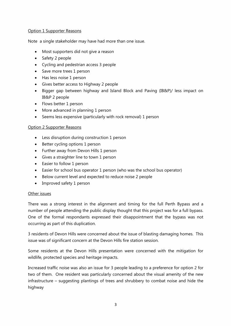
Option 1 Supporter Reasons
Note a single stakeholder may have had more than one issue.
Most supporters did not give a reason Safety 2 people Cycling and pedestrian access 3 people Save more trees 1 person Has less noise 1 person Gives better access to Highway 2 people Bigger gap between highway and Island Block and Paving (IB&P)/ less impact on
IB&P 2 people Flows better 1 person More advanced in planning 1 person Seems less expensive (particularly with rock removal) 1 person
Option 2 Supporter Reasons
Less disruption during construction 1 person Better cycling options 1 person Further away from Devon Hills 1 person Gives a straighter line to town 1 person Easier to follow 1 person Easier for school bus operator 1 person (who was the school bus operator) Below current level and expected to reduce noise 2 people Improved safety 1 person
Other issues
There was a strong interest in the alignment and timing for the full Perth Bypass and a number of people attending the public display thought that this project was for a full bypass. One of the formal respondants expressed their disappointment that the bypass was not occurring as part of this duplication.
3 residents of Devon Hills were concerned about the issue of blasting damaging homes. This issue was of significant concern at the Devon Hills fire station session.
Some residents at the Devon Hills presentation were concerned with the mitigation for wildlife, protected species and heritage impacts.
Increased traffic noise was also an issue for 3 people leading to a preference for option 2 for two of them. One resident was particularly concerned about the visual amenity of the new infrastructure – suggesting plantings of trees and shrubbery to combat noise and hide the highway
4
The period for response submission ends on Friday 8 May but this was extended to 15 May to ensure all feedback was considered and 5 extra comments were received (4 by post, 1 by email and 1 by phone).
A summary of feedback is included at Appendix A.
Stakeholder Engagement Unit
15 May 2015
5
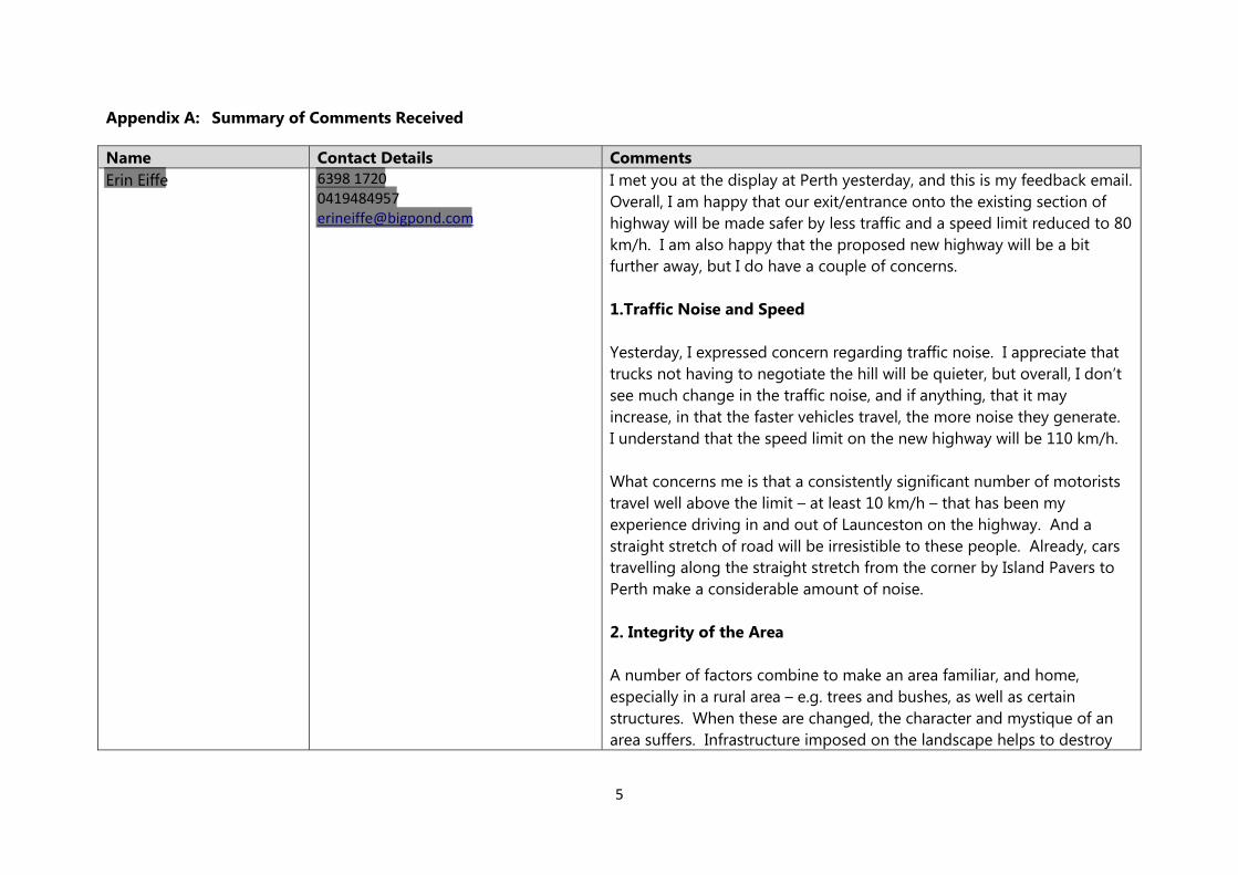
Appendix A: Summary of Comments Received
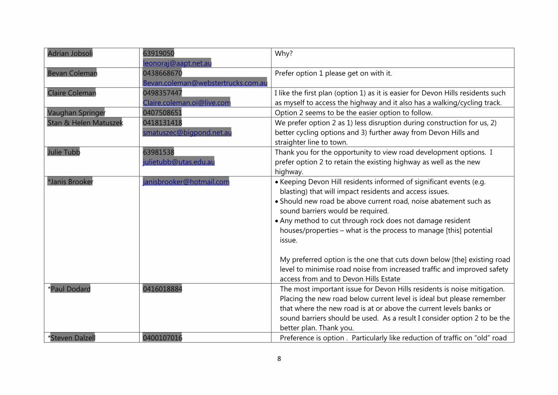
Name Contact Details Comments Erin Eiffe 6398 1720
0419484957 [email protected]
I met you at the display at Perth yesterday, and this is my feedback email. Overall, I am happy that our exit/entrance onto the existing section of highway will be made safer by less traffic and a speed limit reduced to 80 km/h. I am also happy that the proposed new highway will be a bit further away, but I do have a couple of concerns. 1.Traffic Noise and Speed Yesterday, I expressed concern regarding traffic noise. I appreciate that trucks not having to negotiate the hill will be quieter, but overall, I don’t see much change in the traffic noise, and if anything, that it may increase, in that the faster vehicles travel, the more noise they generate. I understand that the speed limit on the new highway will be 110 km/h. What concerns me is that a consistently significant number of motorists travel well above the limit – at least 10 km/h – that has been my experience driving in and out of Launceston on the highway. And a straight stretch of road will be irresistible to these people. Already, cars travelling along the straight stretch from the corner by Island Pavers to Perth make a considerable amount of noise. 2. Integrity of the Area A number of factors combine to make an area familiar, and home, especially in a rural area – e.g. trees and bushes, as well as certain structures. When these are changed, the character and mystique of an area suffers. Infrastructure imposed on the landscape helps to destroy
6
the familiarity and feel of a place. And in most cases, infrastructure is ugly. I am exceedingly disappointed that apparently, there is not the money to consider these important issues. They may not matter to those who do not call this place home, but I feel we should be considered on this point. Ideally, I would like to see a planting of appropriate trees/shrubbery between the existing highway and the proposed new highway. It would go a long way to help dispel noise, and hide the new infrastructure. I was given to understand yesterday that there were not the resources to maintain such a planting, but I wonder if a judicial choice of plants would minimise maintenance of the plantings.
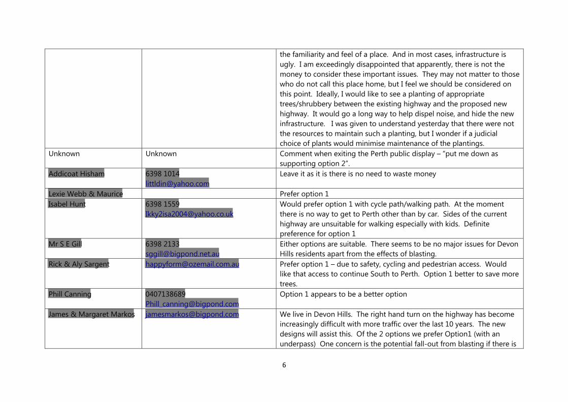
Unknown Unknown Comment when exiting the Perth public display – “put me down as supporting option 2”.
Addicoat Hisham 6398 [email protected]
Leave it as it is there is no need to waste money
Lexie Webb & Maurice Prefer option 1 Isabel Hunt 6398 1559
[email protected] Would prefer option 1 with cycle path/walking path. At the moment there is no way to get to Perth other than by car. Sides of the current highway are unsuitable for walking especially with kids. Definite preference for option 1
Mr S E Gill 6398 [email protected]
Either options are suitable. There seems to be no major issues for Devon Hills residents apart from the effects of blasting.
Rick & Aly Sargent [email protected] Prefer option 1 – due to safety, cycling and pedestrian access. Would like that access to continue South to Perth. Option 1 better to save more trees.
Phill Canning [email protected]
Option 1 appears to be a better option
James & Margaret Markos [email protected] We live in Devon Hills. The right hand turn on the highway has become increasingly difficult with more traffic over the last 10 years. The new designs will assist this. Of the 2 options we prefer Option1 (with an underpass) One concern is the potential fall-out from blasting if there is
7
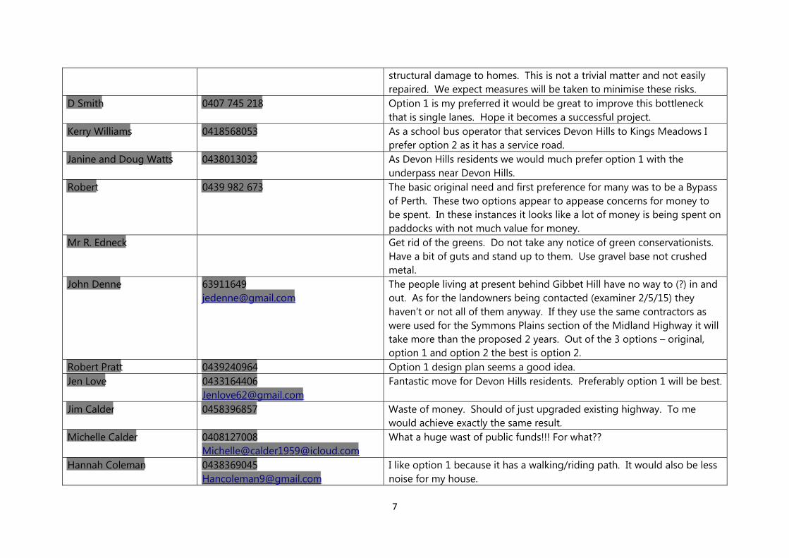
structural damage to homes. This is not a trivial matter and not easily repaired. We expect measures will be taken to minimise these risks.
D Smith 0407 745 218 Option 1 is my preferred it would be great to improve this bottleneck that is single lanes. Hope it becomes a successful project.
Kerry Williams 0418568053 As a school bus operator that services Devon Hills to Kings Meadows I prefer option 2 as it has a service road.
Janine and Doug Watts 0438013032 As Devon Hills residents we would much prefer option 1 with the underpass near Devon Hills.
Robert 0439 982 673 The basic original need and first preference for many was to be a Bypass of Perth. These two options appear to appease concerns for money to be spent. In these instances it looks like a lot of money is being spent on paddocks with not much value for money.
Mr R. Edneck Get rid of the greens. Do not take any notice of green conservationists. Have a bit of guts and stand up to them. Use gravel base not crushed metal.
John Denne [email protected]
The people living at present behind Gibbet Hill have no way to (?) in and out. As for the landowners being contacted (examiner 2/5/15) they haven’t or not all of them anyway. If they use the same contractors as were used for the Symmons Plains section of the Midland Highway it will take more than the proposed 2 years. Out of the 3 options – original, option 1 and option 2 the best is option 2.
Robert Pratt 0439240964 Option 1 design plan seems a good idea.Jen Love 0433164406
[email protected] Fantastic move for Devon Hills residents. Preferably option 1 will be best.
Jim Calder 0458396857 Waste of money. Should of just upgraded existing highway. To me would achieve exactly the same result.
Michelle Calder 0408127008Michelle@[email protected]
What a huge wast of public funds!!! For what??
Hannah Coleman [email protected]
I like option 1 because it has a walking/riding path. It would also be less noise for my house.
8
Adrian Jobsoli [email protected]
Why?
Bevan Coleman [email protected]
Prefer option 1 please get on with it.
Claire Coleman [email protected]
I like the first plan (option 1) as it is easier for Devon Hills residents such as myself to access the highway and it also has a walking/cycling track.
Vaughan Springer 0407508651 Option 2 seems to be the easier option to follow.Stan & Helen Matuszek 0418131418
[email protected] We prefer option 2 as 1) less disruption during construction for us, 2) better cycling options and 3) further away from Devon Hills and straighter line to town.
Julie Tubb [email protected]
Thank you for the opportunity to view road development options. I prefer option 2 to retain the existing highway as well as the new highway.
*Janis Brooker [email protected] Keeping Devon Hill residents informed of significant events (e.g. blasting) that will impact residents and access issues.
Should new road be above current road, noise abatement such as sound barriers would be required.
Any method to cut through rock does not damage resident houses/properties – what is the process to manage [this] potential issue. My preferred option is the one that cuts down below [the] existing road level to minimise road noise from increased traffic and improved safety access from and to Devon Hills Estate
*Paul Dodard 0416018884 The most important issue for Devon Hills residents is noise mitigation. Placing the new road below current level is ideal but please remember that where the new road is at or above the current levels banks or sound barriers should be used. As a result I consider option 2 to be the better plan. Thank you.
*Steven Dalzell 0400107016 Preference is option . Particularly like reduction of traffic on “old” road
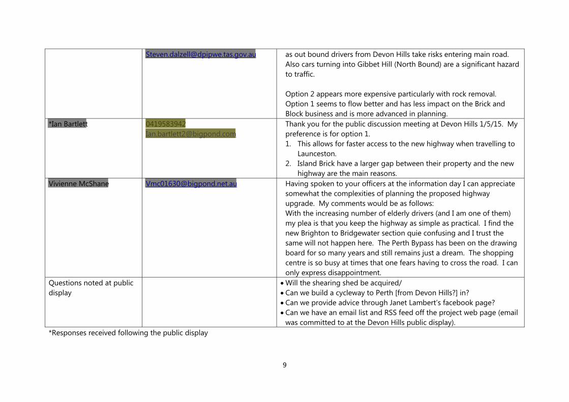
9
[email protected] as out bound drivers from Devon Hills take risks entering main road. Also cars turning into Gibbet Hill (North Bound) are a significant hazard to traffic. Option 2 appears more expensive particularly with rock removal. Option 1 seems to flow better and has less impact on the Brick and Block business and is more advanced in planning.
*Ian Bartlett [email protected]
Thank you for the public discussion meeting at Devon Hills 1/5/15. My preference is for option 1. 1. This allows for faster access to the new highway when travelling to
Launceston. 2. Island Brick have a larger gap between their property and the new
highway are the main reasons. Vivienne McShane [email protected] Having spoken to your officers at the information day I can appreciate
somewhat the complexities of planning the proposed highway upgrade. My comments would be as follows: With the increasing number of elderly drivers (and I am one of them) my plea is that you keep the highway as simple as practical. I find the new Brighton to Bridgewater section quie confusing and I trust the same will not happen here. The Perth Bypass has been on the drawing board for so many years and still remains just a dream. The shopping centre is so busy at times that one fears having to cross the road. I can only express disappointment.
Questions noted at public display
Will the shearing shed be acquired/ Can we build a cycleway to Perth [from Devon Hills?] in? Can we provide advice through Janet Lambert’s facebook page? Can we have an email list and RSS feed off the project web page (email
was committed to at the Devon Hills public display). *Responses received following the public display