Embed Size (px)
Citation preview

MicroSurvey CAD 2018 Features and Benefits
MicroSurvey CAD 2018 includes support for AutoCAD® 2018 .dwg files, Esri® Shapefiles,
Trimble® JobXML files, and important bug fixes that continue to make MicroSurvey CAD the
absolute best choice for land surveying and civil engineering professionals worldwide.
11/3/2017

MicroSurvey Software Inc. October 27, 2017
P:\My Documents\2017\mscad2018-features-benefits.docx Page 1 of 5
Table of Contents MicroSurvey CAD 2018 ................................................................................................................................. 2
New: IntelliCAD 8.4 .................................................................................................................................. 2
New: Esri Shapefile Import ...................................................................................................................... 3
New: Trimble JobXML Import .................................................................................................................. 3
New: 3D Point Labels ............................................................................................................................... 5

MicroSurvey Software Inc. October 27, 2017
P:\My Documents\2017\mscad2018-features-benefits.docx Page 2 of 5
MicroSurvey CAD 2018 Release Date: November 3, 2017
New: IntelliCAD 8.4 Upgrade Tour Movie: click here
Feature Benefit
Open AutoCAD 2018 .dwg files
Open AutoCAD 2018 format .dwg files, via automatic conversion to the 2013 format. A backup copy of the 2018 format is kept.
Performance Enhancements
Improved entity snap performance in drawings with underlays. Improved redraw performance when creating/updating entities in large drawings.
User Interface Improvements
Use the new Drawing Tabs to switch between multiple open drawings. Running on a 4K monitor and switching between high-res monitors is greatly improved. A new Customize dialog allows for easier customization of the user interface.
Express Tools and other new commands
Create entities with the new Multileader, Quick Leader, and Break Line commands. Add styles using the new Multileader Styles Manager and Multiline Style commands. Select entities using the new Select Similar and Get Selection commands. Explode entities with more precision according to entity type using the new Explode Text and Explode Attributes commands. Add more formatting to text using the in-place Multiline Editor and line spacing, lists, and paragraph justification. Add automatic numbering to text, multiline text, multileaders, or block attributes using the new Auto Number command. Get more information about your drawings using the new Drawing Properties command. Create gradient hatch patterns with the revised Boundary Hatch command. Major LISP upgrade with VL*, VLA*, VLAX* functions.
1180+ Bug Fixes IntelliCAD 8.4 includes over 1180+ bug fixes since IntelliCAD 8.2a which powered MicroSurvey CAD 2017, and includes the latest ODA Teigha 4.2.0
MicroSurvey Software Inc. October 27, 2017
P:\My Documents\2017\mscad2018-features-benefits.docx Page 3 of 5
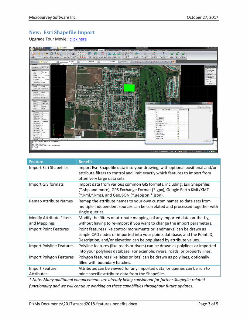
New: Esri Shapefile Import Upgrade Tour Movie: click here
Feature Benefit
Import Esri Shapefiles Import Esri Shapefile data into your drawing, with optional positional and/or attribute filters to control and limit exactly which features to import from often very large data sets.
Import GIS formats Import data from various common GIS formats, including: Esri Shapefiles (*.shp and more), GPS Exchange Format (*.gpx), Google Earth KML/KMZ (*.kml,*.kmz), and GeoJSON (*.geojson,*.json).
Remap Attribute Names Remap the attribute names to your own custom names so data sets from multiple independent sources can be correlated and processed together with single queries.
Modify Attribute Filters and Mappings
Modify the filters or attribute mappings of any imported data on-the-fly, without having to re-import if you want to change the import parameters.
Import Point Features Point features (like control monuments or landmarks) can be drawn as simple CAD nodes or imported into your points database, and the Point ID, Description, and/or elevation can be populated by attribute values.
Import Polyline Features Polyline features (like roads or rivers) can be drawn as polylines or imported into your polylines database. For example: rivers, roads, or property lines.
Import Polygon Features Polygon features (like lakes or lots) can be drawn as polylines, optionally filled with boundary hatches.
Import Feature Attributes
Attributes can be viewed for any imported data, or queries can be run to mine specific attribute data from the Shapefiles.
* Note: Many additional enhancements are already being considered for further Shapefile-related
functionality and we will continue working on these capabilities throughout future updates.

MicroSurvey Software Inc. October 27, 2017
P:\My Documents\2017\mscad2018-features-benefits.docx Page 4 of 5
New: Trimble JobXML Import Upgrade Tour Movie: click here
Feature Benefit
Import raw data from Trimble and Spectra Precision products
The JobXML (*.jxl) format is Trimble’s recommended file format for data exchange between Trimble or Spectra Precision software, such as Survey Pro or Trimble Business Centre, and non-Trimble products like MicroSurvey CAD.
Import Point Coordinates Reduced point coordinates are imported directly from the JobXML file into the MicroSurvey coordinate database.
Import Total Station Data Reduced total station observations are imported directly from the JobXML file into the MicroSurvey coordinate database as OC (Occupied Station) and SS (Sideshot) records, so field errors can be located and corrected, and new coordinates can be re-calculated from the modified data.
Import GPS Coordinates Reduced GPS observations are imported directly from the JobXML file into the MicroSurvey traverse database as GS (GPS Store Point) records.

MicroSurvey Software Inc. October 27, 2017
P:\My Documents\2017\mscad2018-features-benefits.docx Page 5 of 5
New: 3D Point Labels Upgrade Tour Movie: click here
Feature Benefit
3D Point Labels A new System Toggle “3D Point Labels” causes the point labels (including AutoMAP symbols) to be drawn at the same elevation as the point nodes, instead of always being drawn at z=0.
2D Point Nodes The previous “2D Draw Mode” system toggle has been renamed to “2D Point Nodes” to clarify the difference and reduce potential confusion between these two options. Aside from the name change, this option works the same as previous versions: it causes the point nodes to be drawn at z=0, while maintaining the true point elevation in the coordinate database.


![NEW FEATURES - MicroSurveys3.microsurvey.com/fieldgenius/FieldGenius9/9.0/ReleaseNotes.pdf · This is similar to the “Helmerts” functionality in MicroSurvey CAD. [F3051] Menu](https://img.pdfslide.us/doc/110x75/5bc715df09d3f22f508d406d/new-features-this-is-similar-to-the-helmerts-functionality-in-microsurvey.jpg)