Embed Size (px)
Citation preview
Team # _______ Team/School Name ______________________________________
Geologic Mapping – EXAM
2019 UMD InvitationalTeam Number (on your wristband): _____
Team/School Name: __________________________________ No abbreviations / PRINT LEGIBLY
Student Names (First & Last): PRINT LEGIBLY
1. ____________________________________________
2. ____________________________________________
Total Points Possible (written test): 70
Total Points Earned: __________
1. This test is based on the 2019 Division C Rules Manual. 2. You will have 50 minutes for this test. 3. This test is out of 70 points. Each question’s value will be indicated at the end of the
question in parenthesis. 4. Tiebreaker questions are, in this order, 16, 31, 14, 10, 26, 18. 5. The space provided for each question is sufficient for a response earning full points
(although in most cases, there is more space available than necessary. 6. For calculation or measurement questions, answers in an acceptable range will earn full
points. Don’t worry about significant figures.
Team # _______ Team/School Name ______________________________________
7. For both questions and answers, strike convention in this test will be 180-degree true north azimuth form, and dip convention will be in degrees from horizontal with a directional indicator. When paired, strike is listed first.
8. All maps have been sourced from USGS website.
Good Luck!
1. What principle involves the use of fossil records to correlate rock age? (2)
a. Superposition b. Original horizontality c. Faunal succession d. Carbon dating
2. A ______ intrusion is when tabular bodies of igneous rock are spread out as essentially thin,
horizontal sheets between beds or layers of rock. (2) a. Sill b. Laccolith c. Lopolith
3. Mountains formed in the Himalayans, the range separating India and Asia, were a result of
what kind of plate boundary? (2) a. Transform boundary b. Divergent boundary c. Convergent boundary
4. What is the age order of sea floor types from youngest to oldest? (2)
a. Mid-ocean ridge, abyssal plains, abyssal hills, continental shelf b. Mid-ocean ridge, abyssal hills, abyssal plains, continental shelf c. Abyssal plains, abyssal hills, mid-ocean ridge, continental shelf d. Abyssal hills, continental shelf, abyssal plains, mid-ocean ridge
5. What does plate tectonic theory predict about the distribution of volcanoes? (2)
a. They should only occur along continental margins b. They should occur primarily along plate boundaries c. They should occur primarily on continents d. They should be evenly distributed
6. The ________ ________ process is what allows oceanic crust to be forced back into the
earth’s mantle because it is colder and therefore denser. (2) a. Heat dissipation b. Magmic cooling c. Deepwater cooling
Team # _______ Team/School Name ______________________________________
d. Slab pull
7. If a dike protrudes through several layers of rock, what does that tell us? (2) a. A volcano is located nearby b. The rock layers formed before the dike c. The dike formed before the rock layers d. The rocks are igneous
8. What type of fault results from compression between two tectonic plates? (2)
a. Reverse fault b. Strike-slip fault c. Normal fault
9. What is an unconformity? (2)
10. What is the difference between a concordant and discordant intrusion? (2)
11. How do sedimentary rocks form? (2)
12. What was the last supercontinent that combined all present-day continents? (2)
Team # _______ Team/School Name ______________________________________
13. Approximately how long has it been since the last ice age ended? (2)
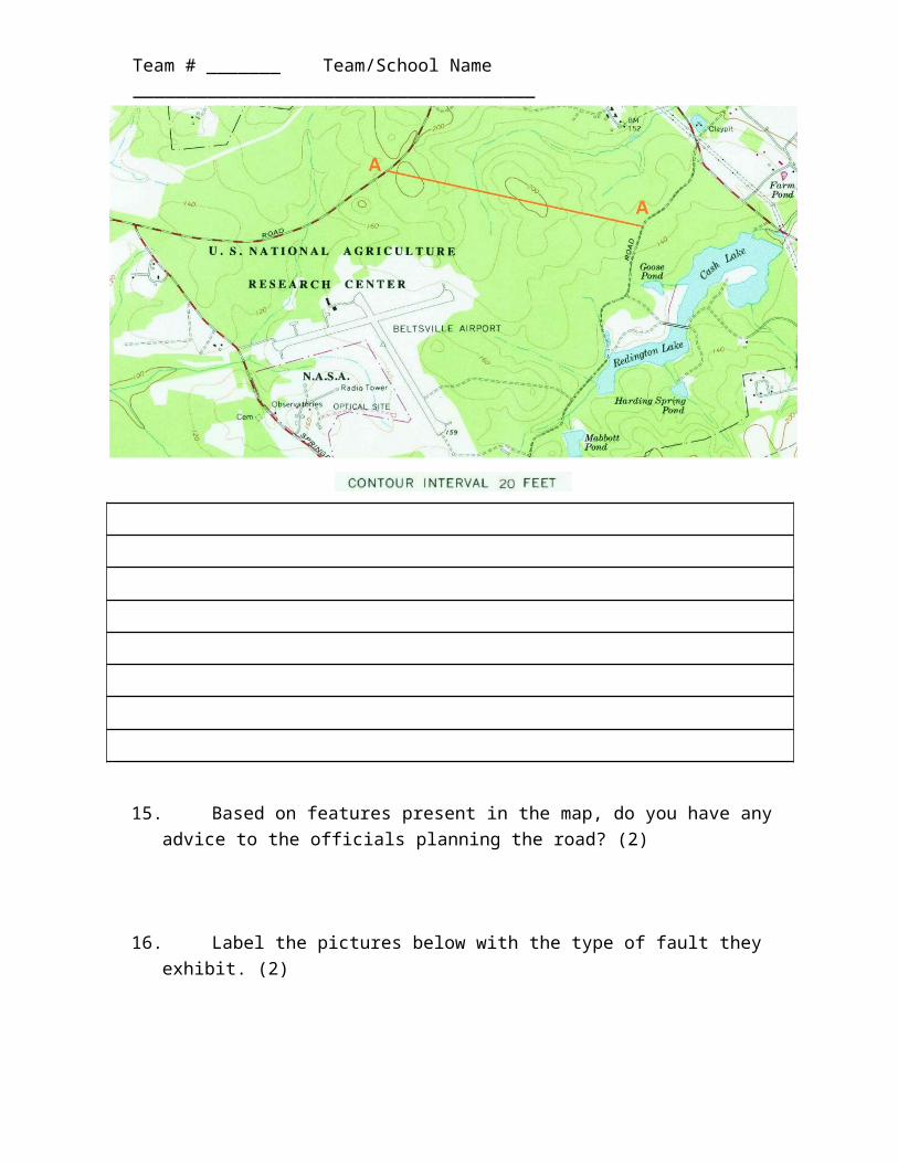
14. A new road has been proposed at the U.S. National Agriculture Research Center, but
official are worried about road incline. You are tasked with drawing a topographical profile for the proposed road, shown as A-A above in orange. Draw this on the template below. Make sure to define the vertical axis. (4)
15. Based on features present in the map, do you have any advice to the officials planning the road? (2)
Team # _______ Team/School Name ______________________________________
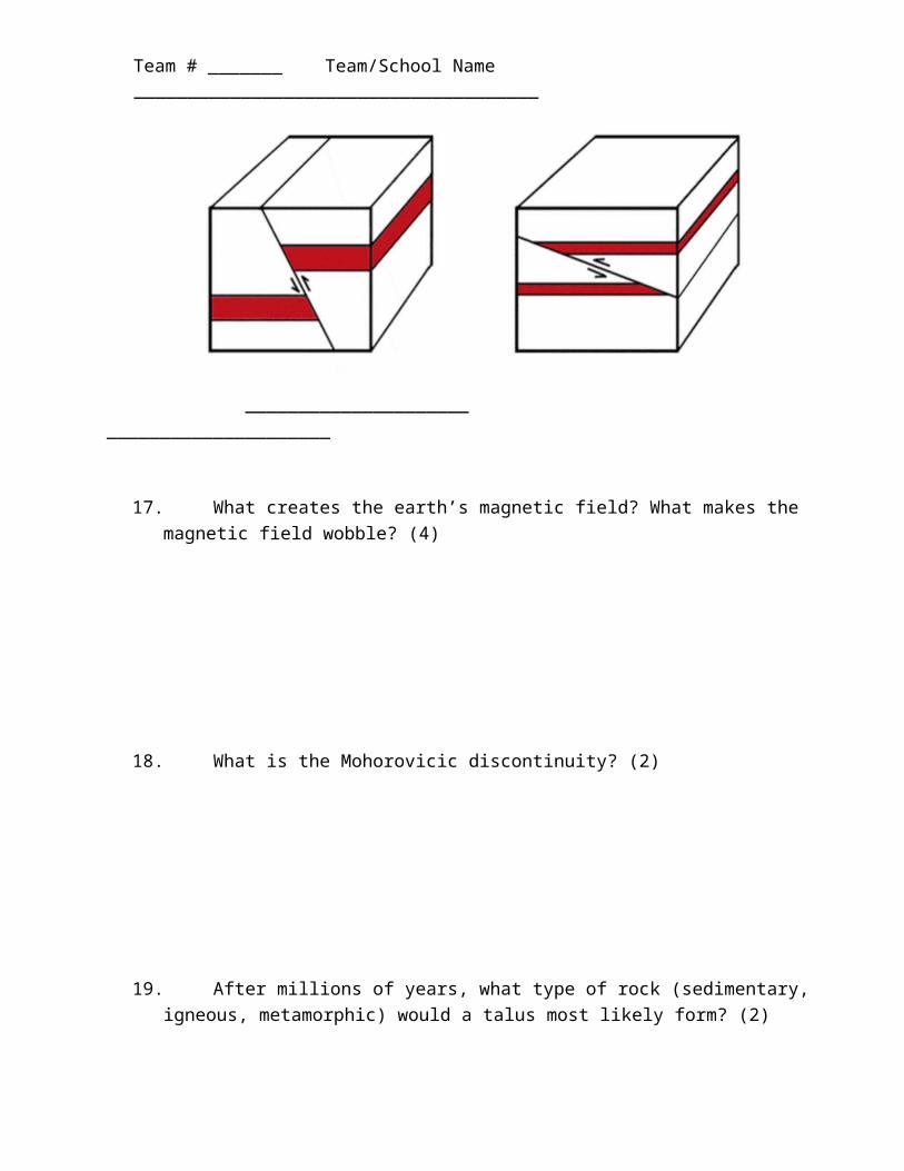
16. Label the pictures below with the type of fault they exhibit. (2)
_____________________ _____________________
17. What creates the earth’s magnetic field? What makes the magnetic field wobble? (4)
18. What is the Mohorovicic discontinuity? (2)
19. After millions of years, what type of rock (sedimentary, igneous, metamorphic) would a talus most likely form? (2)
Team # _______ Team/School Name ______________________________________
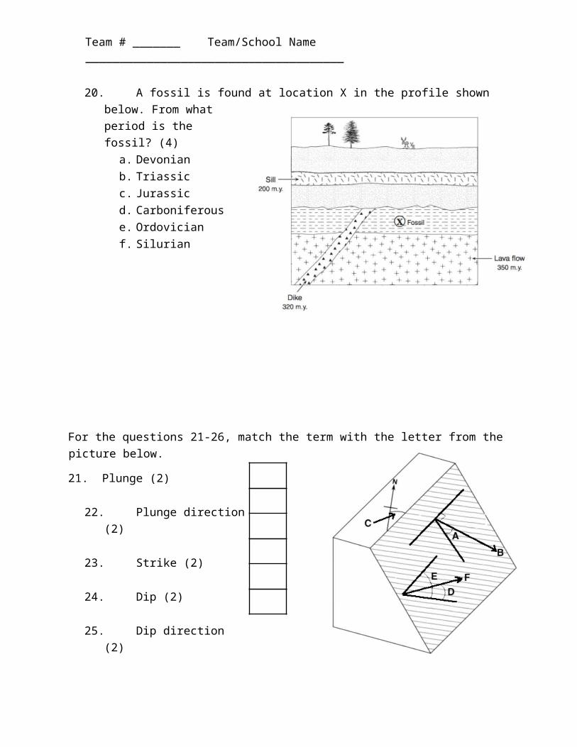
20. A fossil is found at location X in the profile shown below. From what period is the fossil? (4)
a. Devonian b. Triassic c. Jurassic d. Carboniferous e. Ordovician f. Silurian
For the questions 21-26, match the term with the letter from the picture below.
21. Plunge (2)
22. Plunge direction (2)
23. Strike (2)
24. Dip (2)
25. Dip direction (2)
26. Rake (2)
All the remaining questions reference the Mt. Cardigan map provided at the end of this test packet.
27. What is the scale of this map? (1)
Team # _______ Team/School Name ______________________________________
28. What is the highest possible elevation for point X? (2)
29. What is the highest elevation at any point on this map? (2)
30. What is the gradient across segment AB? (3) a. 900ft/mile b. 1000ft/mile c. 800ft/mile d. 400ft/mile
31. What is the dip across segment CD? You can assume the endpoints are at the absolute peaks. (4)
Team # _______ Team/School Name ______________________________________


![[PPT]PowerPoint Presentation - California State University ... · Web viewGeologic Time Physical Geology Chapter 8 Tim Horner, CSUS Geology Department Dating rocks: Relative dating:](https://img.pdfslide.us/doc/110x75/5ab80ecc7f8b9ac1058c3b1a/pptpowerpoint-presentation-california-state-university-viewgeologic-time.jpg)