Embed Size (px)
Citation preview
City of IndependenceTotal Maximum Daily Load (TMDL) Implementation Plan
October 2008
Prepared by David Evans and Associates, Inc.

City of Independence
Total Maximum Daily Load (TMDL)
Implementation PlanOctober
2008
Prepared by David Evans and Associates, Inc.
2100 SW River ParkwayPortland, OR 97201
DEA Project No. INDP0000-00030

Table of Contents
SECTION 1 INTRODUCTION ................................................................................................. 1SECTION 2 BACKGROUND................................................................................................... 2
2.1 Overview of TMDL Requirements ...............................................................................................22.2 TMDL Parameters .......................................................................................................................32.3 Temperature .............................................................................................................................. ..32.4 Bacteria.............................................................................................................................. ..........42.5 Mercury .............................................................................................................................. ..........52.6 Middle Willamette Subbasin ........................................................................................................62.7 Rickreall Creek Subbasin and Ash Creek Watershed.................................................................82.8 City of Independence.................................................................................................................. .9
SECTION 3 WATER QUALITY ASSETS AND GAPS............................................................ 93.1 Water Quality Assets ...................................................................................................................93.2 Gaps .............................................................................................................................. ............10
SECTION 4 COMPONENTS OF IMPLEMENTATION PLAN ............................................... 104.1 Riparian Protection and Restoration..........................................................................................114.2 Animal Waste Management ......................................................................................................114.3 Stormwater Planning and Management ....................................................................................124.4 Erosion Control ......................................................................................................................... .124.5 Illegal Discharge ....................................................................................................................... .124.6 Wastewater Treatment Plant .....................................................................................................134.7 Education/ Training................................................................................................................... .13
SECTION 5 PLAN IMPLEMENTATION AND REPORTING REQUIREMENTS................... 135.1 Implementation Tracking Matrix ............................................................................................... .135.2 Plan Review, Revision, and Reporting Requirements...............................................................135.3 Evidence of Compliance with Land Use Requirements ............................................................145.4 Program Funding ...................................................................................................................... .145.5 Public Involvement Plan for Strategy Implementation...............................................................14
SECTION 6 REFERENCES .................................................................................................. 14
TablesTable 1 - City of Independence Existing Water Quality Related Program and Policy Inventory .................. 9Table 2 - Pollutant Reduction Focus Areas for the City of Independence .................................................. 10
MapsMap 1 – The Willamette Subbasin ............................................................................................................... 7Map 2 – Luckiamute/Ash Creek/American Bottom Watershed Map............................................................ 8
AppendixAppendix A – TMDL Implementation Tracking Matrix: Independence, Oregon

October 2008 City of IndependenceTMDL Implementation Plan
Page 1
SECTION 1 INTRODUCTION
The Willamette River and numerous tributaries do not currently meet several water quality standards including bacteria, mercury and temperature established by the federal Clean Water Act. These standards assure that beneficial uses of the river and tributaries, such as swimming, fish consumption and fish rearing, are protected. When water quality standards are not met, a Total Daily Maximum Load (TMDL) Implementation Plan is required to be established. A TMDL determines how much pollution can be added to the river without exceeding water quality standards.
This document is the Total Maximum Daily Load (TMDL) Implementation Plan for the City of Independence. This Plan describes the strategies that the City will implement to reduce temperature, bacteria, and mercury pollution in the Middle Willamette River Subbasin. Implementation Plans from Designated Management Agencies, such as the City of Independence, are required to comply with the Willamette Basin TMDL order and to help meet pollutant load allocations for the Middle Willamette Subbasin as approved by the US Environmental Protection Agency (EPA) in September2006.
This plan is organized into six sections. This first section introduces the Plan, the second section gives a brief overview of the TMDL program, describes each of the three major pollutants addressed in the Willamette Basin TMDL (Temperature, Bacteria, and Mercury), and explains the region’s water resources, land use, and important issues related to water quality. This section also includes an overview of the Middle Willamette Basin and the City of Independence. Section three explains what the City of Independence is currently doing to address water quality issues, and points out where gaps exist in addressing TMDL parameters. The fourth section is the “core” of this Implementation Plan and portrays what the City plans to do to address TMDL issues. Section 5 outlines how strategies will be implemented and also identifies how effective implementation will be measured and how the strategies will be funded. Section 5 is supplemented by Appendix A: TMDL Implementation Tracking Matrix: Independence, Oregon. Section 6 lists the references used while writing this plan.
The overarching goal of this Implementation Plan is to limit or, wherever possible, reduce heat, bacteria, and mercury contributions to surface waters within the jurisdictional control of the City of Independence. Through a multi-faceted approach of land use ordinances, public operations, partnerships, projects, and education this plan targets specific sources of contamination within the City’s jurisdiction.

October 2008 City of IndependenceTMDL Implementation Plan
Page 2
SECTION 2 BACKGROUND
The Willamette River is a very important commercial, municipal, cultural, recreational, ecological, and aesthetic asset. Working to preserve and maintain water quality will ensure prosperity, productivity, and quality of life for the entire Willamette region now and in the future. Water quality in all the regions is vital in maintaining the functionality of this river system.
In the southernmost part of the Willamette Basin, upland forest streams begin as mere spring-fed rivulets, snowmelt drainages, or small mountain lakes. These watercourses join with other small streams and flow into major tributaries; the Mohawk, McKenzie, Middle Fork Willamette, Row, Coast Fork Willamette, Santiam, and Long Tom Rivers. By the time the Willamette River passes the City of Independence it is about 60 feet wide and flowing on average at 6,700 cubic feet per second (cfs). The City of Independence lies on the west bank of the Willamette River at river mile 95.8.
On its way to the Columbia River, the Willamette passes the state’s three largest cities and nearly two million people. In the next 45 years, an additional 1.7 million people are expected to be living on the land adjacent to the Willamette River and its tributaries. Current and future generations of Oregonians depend on the Willamette and its tributaries to provide water for drinking, industrial uses, sanitary functions, recreation, aesthetic enjoyment, fish and wildlife habitat, and many other purposes.
Functional water resources are essential to protecting the future health and prosperity of the Willamette Valley. The Oregon Department of Environmental Quality (DEQ) has set water quality standards for the waterways in the region to protect beneficial uses such as drinking, fishing, swimming, fish spawning, and irrigation. Streams, lakes, and rivers that do not meet these standards are included in the statewide 303(d) list of impaired waterbodies.
2.1 Overview of TMDL RequirementsThe Clean Water Act of 1977 authorizes the U.S. Environmental Protection Agency (EPA) to restore and maintain the physical, chemical, and biological integrity of all waters of the nation. In response to the Clean Water Act, the EPA designated state agencies to develop water quality standards, perform water quality monitoring to understand current conditions, determine sources of pollution, and develop TMDLs as a tool to improve water quality. As a component of the overall effort to protect and restore the beneficial uses of Oregon’s waterbodies, the DEQ issued TMDLs for 10 of the12 subbasins of the Willamette River in September 2006.
The TMDL process begins when a stream, lake, or river does not meet water quality standards and is classified as water quality-limited on the state’s 303(d) list. TMDLs identify the maximum amount of a specific pollutant that can be present in a water body without violating water quality standards. This is known as the loading capacity. After extensive water quality monitoring and modeling efforts, TMDLs establish the difference between the loading capacity and the current pollutant load. TMDLs are expressed as numeric standards or percent pollutant reductions that need to be met to bring water bodies into compliance with water quality standards. The difference between the current load and the loading capacity is known as excess load.

October 2008 City of IndependenceTMDL Implementation Plan
Page 3
The excess load is split up between the different sources of pollution according to their contribution to the overall pollution load. Any difference between the waterway’s loading capacity and the current pollutant load must be mitigated by pollution reduction activities. The DEQ develops wasteload allocations for point sources such as wastewater treatment plants and industrial discharges. They develop load allocations for non-point pollution from agricultural, urban, and forestry lands such as erosion, animal wastes, and stormwater.
The Oregon Administrative Rule (OAR 340-042-0080) that addresses TMDLs requires local governments and other agencies to develop TMDL Implementation Plans. Responsible parties that are able to implement pollution reduction strategies are classified as Designated Management Agencies (DMAs). In the Willamette Basin, DMAs include federal agencies such as the Bureau of Land Management, state agencies such as the Department of Forestry and the Department of Agriculture, counties, cities, and others. According to the OARs, TMDL Implementation Plans must include the following five elements:
1 Management strategies that will be used to achieve load allocations2 A timeline and schedule to achieve measurable milestones3 A plan for periodic review and revision of the implementation plan4 Evidence of compliance with applicable statewide land use requirements
Any other analyses or information as specified in the Water Quality Management Plan
The Oregon Department of Agriculture (ODA) is working with farmers to address contributions from farmland, the Oregon Department of Forestry is addressing contributions from forestland, and federal land management agencies are implementing TMDLs according to their internal procedures. Point sources, such as wastewater treatment facilities will be addressed through their individual permitting processes. Cities and counties must address contributions through the development of Implementation Plans.
2.2 TMDL ParametersTemperature, bacteria, and mercury are the three parameters that have been included in all of the Willamette Basin TMDLs. Although other parameters are included in subbasin TMDLs, these three pollutants are the major concerns throughout the entire Willamette Basin. Following are brief summaries of these three TMDL parameters, but more in-depth information on these parameters and the processes used to develop the TMDLs can be found in Chapters 2, 3, and 4 of the Willamette Basin TMDL. The summaries below include basic information about the characteristics of the parameter, the potential sources of each pollutant, waterways in the region not meeting water quality standards, and a brief list of potential strategies to address each parameter.
2.3 TemperatureAt times, the Willamette River and its tributaries are too warm to support healthy salmon and trout. Some of these cold water fish including lower Columbia Coho, Spring Chinook, Winter Steelhead, and Bull Trout are threatened with extinction and elevated stream temperatures have contributed to their decline. Warm water interferes with adult salmon and trout migration and spawning. Warm water also decreases chances of juvenile survival, affects egg and embryo development, alters juvenile fish growth rates, and decreases their ability to compete with temperature-tolerant fish species for habitat and food. Salmon and trout are also more susceptible to disease when water

October 2008 City of IndependenceTMDL Implementation Plan
Page 4
temperatures are warmest. In December 2003, the Environmental Quality Commission adopted a new temperature for salmon and trout rearing and migration of 64.4 degrees Fahrenheit (18.0°C).
The increase in the river water temperature is known as thermal pollution. Removal or disturbance of streamside vegetation is the primary activity that negatively impacts stream temperature due to the loss of shade cover, but water temperature is also affected by erosion, loss of channel complexity, low streamflows, dams, and heated discharges from industrial or municipal operations.
The major sources of thermal pollution that the DEQ evaluated for the Willamette Basin temperature TMDLs are wastewater treatment facilities, dam and reservoir operations, and the loss of streamside vegetation. Point sources will continue to be regulated through the existing National Pollution Discharge Elimination System (NPDES) permit methods. Sewage treatment plants, as well as large industrial permitted discharges, will be allocated heat loads during the next renewal of their NPDES permits. As part of the TMDL requirements OAR 340 restricts all NPDES point sources and nonpoint sources to a cumulative increase of no greater than 0.3 degrees Celsius.
The focus of the non-point source temperature TMDL is to mitigate the removal or disturbance of streamside vegetation. The most effective way to minimize thermal pollution is by reducing the amount of solar radiation that reaches the water. This is accomplished by protecting and reestablishing vegetation along waterways to provide shade cover. Temperature benefits can also be realized through stream restoration projects including streambank stabilization, increasing stream flows, decreasing channel width, and restoring channel complexity.
The major implication of the temperature TMDLs is the protection and restoration of streamside vegetation. Examples of options to address thermal pollution include mechanisms such as:
• Develop materials that explain why landowners should preserve natural streamside vegetation
• Implement demonstration projects on public land to illustrate potential riparian management techniques
• Institute a riparian ordinance that prohibits the removal of native streamside vegetation• Acquire critical streamside property• Become involved in a water quality trading program• Actively restore riparian areas on public land and help private property owners restore
riparian areas on private land
2.4 BacteriaPeople can be affected by bacteria present in water when enjoying water activities such as swimming, wading, wind surfing, water skiing, boating, or fishing. Ingestion or contact with water contaminated with bacteria can cause skin and respiratory ailments, gastroenteritis and other illnesses in humans.
DEQ has set planning targets for DMAs in order to prevent the degradation of water quality. Chapter Two of the Willamette Basin TMDL, states that in subbasins with no listings, generalized reductions will be used as planning targets by designated management agencies. The bacteria targets are generalized into percent reduction ranges that are applied in all the subbasins of the Willamette Basin. These planning targets have been allocated among the two major land uses that contribute bacteria to waterways; agricultural and urban. The Willamette Basin Bacteria TMDL states that

October 2008 City of IndependenceTMDL Implementation Plan
Page 5
urban areas must reduce their bacteria contributions by 75% in the fall, winter, and spring and 88% in the summer and agriculture areas by 61% year round to meet water quality standards for the general Middle Willamette Basin area.
Bacteria violations of water quality standards are most common in creeks and streams that drain urban and agricultural land. The mainstem Willamette River is water quality limited for bacteria during the high flows of the fall-winter-spring months, but is in compliance during summer low flows when there is the least amount of runoff. Above Willamette Falls, violations in the bacteria standards are usually single sample events that are related to high levels of precipitation and the resulting runoff.
The major sources of bacteria in the urban and rural residential areas are stormwater runoff, erosion, domestic and wild animal waste, failing septic systems, and municipal sewer overflows. Other sources of bacteria include livestock, irrigation runoff, and streambank erosion.
Local jurisdictions can focus on urban issues to ensure that the quality of water does not degrade due to current land use, population growth, and land use changes. Strategy options to address bacteria in the urban area include:
• Preventing erosion and controlling sediment from new construction• Detaining and treating stormwater prior to discharge into waterways• Keeping stormwater conveyance channels clear of organic matter• Controlling animal waste• Maintaining and restoring riparian buffers• Encouraging better site design to decrease runoff• Preventing non-stormwater and illegal discharges• Developing stewardship and educational programs to prevent pollution• Street sweeping
2.5 MercuryThe accumulation of mercury in fish is a well recognized environmental problem throughout the United States. Mercury is a potent toxin that can cause damage to the brain and nervous system. Small children and the developing fetus are most sensitive to mercury’s toxic effects. The primary way that humans are exposed to mercury is through the consumption of fish or seafood containing elevated levels of mercury.
Mercury is a very complex pollutant. The way it acts in nature and the different forms it takes make it difficult to understand and accurately monitor. With no regard to local, state, or even international boundaries, mercury can be transported in the air after soil disturbance, automobile emissions, and industrial emissions across many miles and deposited by rainfall. Air deposition from emissions is one of many ways that mercury moves through the environment. Some point sources, including timber processing plants and mills, discharge low levels of mercury in their wastewater effluent.
Stormwater runoff suspends mercury molecules and carries them to waterways.
Mercury is naturally occurring at low levels, but when native soil erodes at an accelerated rate those molecules are released in abnormal amounts. Mercury is also set in motion when sediment that has been deposited long ago is re-suspended due to high flows or a significant disturbance.

October 2008 City of IndependenceTMDL Implementation Plan
Page 6
High mercury levels in the Willamette Basin have resulted in fish consumption advisories. To protect public health, especially that of pregnant women and young children, the Department of Human Services (DHS) has issued advisories recommending that people limit the amount of fish they consume from certain waterways. The DHS specifically advises against consuming large amounts of fish from the Willamette River and other tributaries due to the high levels of mercury. The Willamette Basin TMDL specifies a 26.4% reduction needed (128.5 kg/year). Sources of mercury for the Willamette Basin and estimated percentage contribution include:
• Erosion of native soil (47.8%)• Atmospheric deposition and runoff, including stormwater (47.7%)• Point sources (3.9%)• Legacy mines (0.6%)• Low levels are naturally occurring
Despite the uncertainty and complex nature of mercury, there are steps that can be taken to minimize the amount of mercury that is deposited in waterways and accumulated in the tissues of fish, wildlife, and humans. The goal of the mercury TMDL is to reduce mercury levels in the basin to a point where fish are no longer unsafe to eat.
To begin addressing the mercury problem in the Willamette Basin, the DEQ has developed interim allocations for point sources and non-point sources while they conduct more in-depth research. Instead of specific allocations, the DEQ calculates the interim mercury TMDLs based on two categories: non-point and point sectors. The DEQ expects all non-point sources to begin implementing mercury reduction management strategies and policies. The TMDL will be revised in the future to be more specific according to the results of further research.
Implementation plans must include a mercury reduction strategy that includes feasible measures to minimize mercury runoff. DMAs have an array of options to reduce mercury pollution. Many of the management strategies that address mercury pollution also address bacteria and temperature. Potential management strategies include:
• Working with dentist offices to properly dispose of mercury wastes• Establishing a stormwater plan with water quality protection components• Stormwater detention and treatment prior to discharge into waterways• Establishing an erosion prevention and sediment control program• Regular street sweeping and stormwater system maintenance• Limiting land disturbance whenever possible
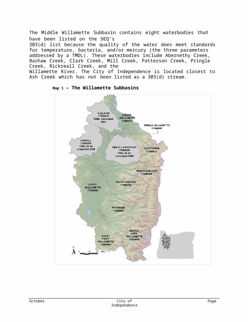
2.6 Middle Willamette SubbasinThe Middle Willamette (shown on Map 1) Subbasin includes the cities of Stayton, Turner, Oregon City, Wilsonville, Newberg, Canby, Dundee, Donald, Saint Paul, Keizer, Salem, Dallas, Independence, Monmouth, Aumsville, Sublimity, and a portion of West Linn. Most of the 698 square miles is privately-owned. Land uses are primarily agriculture, forestry, and urban. However there are small, scattered areas of public land managed by the Bureau of Land Management (BLM) and the State of Oregon

October 2008 City of IndependenceTMDL Implementation Plan
Page 7
The Middle Willamette Subbasin contains eight waterbodies that have been listed on the DEQ’s303(d) list because the quality of the water does meet standards for temperature, bacteria, and/or mercury (the three parameters addressed by a TMDL). These waterbodies include Abernethy Creek,Bashaw Creek, Clark Creek, Mill Creek, Patterson Creek, Pringle Creek, Rickreall Creek, and theWillamette River. The City of Independence is located closest to Ash Creek which has not been listed as a 303(d) stream.
Map 1 – The Willamette Subbasins
October 2008 City of IndependenceTMDL Implementation Plan
Page 8
2.7 Rickreall Creek Subbasin and Ash Creek WatershedThe Rickreall Creek Watershed drains a 183 square mile (117,119 acres) area of the Middle Willamette Subbasin. The watershed has four major tributaries that contribute to the Willamette River flow; Rickreall Creek, Ash Creek, Luckiamute River, and Bashaw Creek. Agriculture accounts for approximately 61% of land use in the watershed, with forestry land use accounting for 33% of use, and 6% for rural residential use. There are four individual NPDES permits in the watershed, one of them the City of Independence and Monmouth, which discharges directly to the Willamette River.
The City of Independence is located at the confluence of Ash Creek with the Willamette River and as a result has water quality impacts on the creek. Although Ash Creek is not on the 303 (d) list, the City is still responsible for creating targets for the reduction of temperature, bacteria, and mercury contributions according to the Middle Willamette TMDL order. The Ash Creek study area/watershed (see Map 2 below) is managed by the Luckiamute Watershed Council (LWC). The LWC is a group of volunteers from neighboring communities that work together to protect and enhance the area’s natural resources. They work with local agencies, schools, landowners, industries, and businesses to restore habitat for fish and wildlife. They also provide students with educational experiences in the natural sciences.
Map 2 – Luckiamute/Ash Creek/American Bottom Watershed Map
October 2008 City of IndependenceTMDL Implementation Plan
Page 9
2.8 City of IndependenceIn 2006, the City of Independence’s population was estimated at 7,715. Current zoning indicates that51 percent of land in the Independence urban growth boundary will be used for residential purposes,5 percent for commercial, 19 percent for industrial, 6 percent for agriculture, and the remaining18 percent for parks or public facilities. Situated 10 miles southwest of Salem, City of Independence has seen, and is expecting, steady, constant growth in the years to come. Independence was founded in 1885 by pioneers who migrated from Independence, Missouri. The City remains a vibrant, historic, riverfront, full-service community with a small town feel.
According to preliminary estimates, Independence’s population is expected to double over the next20 years to over 14,500 residents. To accommodate this growth the existing urban growth boundary may be expanded by 364 acres by 2029, the majority of the industrial growth occurring in the northwest part of the City and the majority of the residential growth occurring southwest (neither area is in close proximity to Ash Creek or the Willamette River and are outside of 100-year floodplain).
Consequently, adverse impacts to water quality as a result of this development may include increased impervious surface areas that may contribute more pollutants through the associated increase in runoff and loss of infiltration capacity. By implementing the strategies contained in this plan, the City will greatly reduce adverse impacts to water quality within its jurisdiction. This plan will be reviewed periodically to ensure that the protective mechanisms suggested are indeed addressing the growth issues in Independence.
SECTION 3 WATER QUALITY ASSETS AND GAPS
Although the City of Independence is not located in the headwaters of the Willamette Basin, it is located upstream of several major cities along the Willamette. Minimizing the pollution here is critical to the maintenance and restoration of clean water downstream in the Willamette Basin. The City is already doing many things to protect and restore water quality. Additional actions are identified in this Implementation Plan that will continue to protect waterways and prevent further water quality degradation.
3.1 Water Quality AssetsThere are currently many water quality efforts underway in the City of Independence. Independence’s Development Code includes erosion control standards for new development and an ordinance encouraging the retention of natural vegetation on construction sites and has prohibited any development within 25 feet of Ash Creek. Table 1 displays an inventory of water quality related measures and documents already in place within the City.
Table 1 - City of Independence Existing Water Quality Related Program and Policy Inventory
Existing Programs, Ordinances, and Practices Existing DocumentsPet waste pick-up Comprehensive PlanLeaf pick-up program Parks and Open Space Master PlanLandscaping standards Development codeAsh Creek development setback Stormwater Master Plan
Source Water Assessment

October 2008 City of IndependenceTMDL Implementation Plan
Page 10
3.2 GapsAs a result of existing water quality programs and activities, many water quality protection improvements have been made. Specific water quality gaps have been identified through the review of related water quality materials including the Willamette Basin TMDLs. Analysis of existing policies and programs indicates that Independence should focus on protecting and restoring streamside vegetation, strengthening the mechanisms designed to minimize erosion, and reducing stormwater runoff. Some aspects of these efforts can be integrated into stormwater planning as well as other existing plans and programs.
The level of priority for actions was determined by comparing the inventory of existing water quality-related programs and policies to the strategies identified in the DEQ’s Water Quality Management Plan. Priority rating also considers the fact that temperature, bacteria, and mercury are equally widespread pollutant in the Middle Willamette Subbasin. Table 2 below outlines the focus areas that are of special concern for the City of Independence. The table assigns a high, medium, or lower priority to seven major focus areas using the methodology described above.
Table 2 - Pollutant Reduction Focus Areas for the City of Independence
Strategy Category PriorityRating
Riparian Protection and Restoration HighWastewater Treatment HighStormwater Planning, Management HighErosion Control HighAnimal Waste Management MediumEducation/Training MediumIllegal Discharge Low
SECTION 4 COMPONENTS OF IMPLEMENTATION PLAN
With City of Independence’s proximity to the Willamette River and its 303(d) listing for temperature, bacteria, and mercury Independence has selected a package of strategies to meet the following objectives:
• reduce heat loads to less than 0.3 degrees C,• meet a planning target of 75 % reduction in bacteria loading during fall, winter, and spring,
and 88% during summer and• minimize mercury contributions.
The City of Independence compared the results of the gaps analysis with potential actions to minimize pollutants of concern. To reduce contributions of heat, bacteria, and mercury, the City will pursue 24 water quality protection actions. These water quality protection actions fulfill the six control measures for mercury and bacteria reductions as stipulated by the Willamette Basin Water Quality Management Plan (WQMP) for populations less than 10K. These six control measures include:
1) Pollution prevention in municipal operations2) Public education and outreach on stormwater impacts

October 2008 City of IndependenceTMDL Implementation Plan
Page 11
3) Public involvement/participation4) Illicit discharge detection and elimination5) Construction site storm water runoff control6) Post-construction stormwater management in new development and redevelopment.
Following is an overview of the actions categorized by focus areas.
4.1 Riparian Protection and RestorationWhen the TMDL process was initiated, the City of Independence already had riparian protection mechanisms in place. Subchapter 54 of the City Code lays out the requirements for landscaping, irrigation, and screening for new developments. Subchapter 54 also established a 25-foot greenway along the banks of Ash Creek and states that these activities are not allowed: “construct or alter a structure, to erect a fence, to conduct a mining operation, to conduct filling, grading, paving, excavation or drilling operations, to make physical change in the use of land.” The ordinance limits the disturbance of soil and creation of new runoff near the creek. Planting, replanting, and removing invasive species activities do no fall under the setback requirements. .
In the past, community groups have come forward with funds wishing to do a riparian/restoration project and asked the City where the funds could best be used. The City will continue to support such efforts and provided formal support and recommendations in the future.
The City is in the process of planning Ash Creek Trail Park. The park will create open space and restoration opportunities and will offer residents and visitors a non-motorized alternative between Independence and Monmouth. There are several restorations opportunities associated with the project. One method of restoring some of areas along the stream is re-establishing native vegetation and provided bank stabilizing, stream shading to improve water quality and, riparian habit for wildlife. Potential restoration sites that have been identified are: “Gulch” in the City of Independence, east of Gun Club Road, Wildfang Park, Riverview Park, and Monmouth wastewater treatment facilities. Information kiosks at the trailheads will provide trail users with information about the ecology of Ash Creek and its watershed.
In the past, the City has also partnered with the LWC for watershed restoration projects. No specific projects are currently identified for the City to partner with LWC. The City will contact the LWC and discuss possible projects to meet the goal of completing at least one riparian tree planting projects every two years. In addition, the City will provide the formal support and resources (as available) for the projects.
The City will also make information about shading vegetation and water temperature available at theCity Hall front counter and on the City’s website.
4.2 Animal Waste ManagementThe City of Independence will bolster the existing pet waste pick-up ordinance by making pet waste stations readily available for use. The City will install and maintain at least ten pet waste pick-up stations in public areas. The stations will include signs and be stocked with bags. News releases will accompany the installation of the new stations to encourage citizens to use them. Following installation of these stations, the City will increase their efforts to enforce the existing ordinance.
October 2008 City of IndependenceTMDL Implementation Plan
Page 12
4.3 Stormwater Planning and ManagementStormwater planning and management is key to the City’s TMDL efforts. The City recognizes that actions taken to manage stormwater will reduce pollutants such as dissolved oxygen, dieldrin, copper, lead, and zinc that are not regulated by the current Willamette Basin TMDL. Subchapter 55 of Independence’s City Code addresses stormwater water quality. Any development resulting in the exposure of more than 60,000 square feet of soil at a time or for 10,000 square feet of impervious surface is required to submit a stormwater management plan. The City is also planning to update their existing stormwater master plan. The updated plan will include specifics on water quality consideration and priorities. This will ensure that future stormwater system expansions and upgrades are designed and constructed to properly treat stormwater. This plan will also include a map of the stormwater system that will aid decision-making about where to focus water quality protection activities.
The City of Independence is pursing several Low Impact Development (LID) projects. Two current developments include Independence Station (a three story multi-use structure, LEED platinum), and the new City Hall building. These LID projects will use sustainable practices to reduce and treat stormwater runoff. The City has also contracted with SERA Architects of Portland to provide urban design consulting services on the twelve month “INDY 20/20 Vision” project. A major portion of this work involves a development code audit and updated development standards which will provide sustainable land use and development practices.
4.4 Erosion ControlCurrent City Code requires prevention of adverse downstream water quality impacts which would include erosion control. Stormwater management plans submitted by the developer must show that existing trees are being retained where possible and other information about methods used to limit runoff from the site. An update to the existing development code will contain specific provisions for erosion control mechanisms in new developments less than one acre. For development activities that disturb one acre or more, the City will make sure that these developments have submitted necessary documentation to DEQ to comply with 1200-C requirements.
Activities to protect and restore riparian areas along with stormwater management strategies described in other sections will lessen the amount of land vulnerable to excessive erosion while also reducing the erosive action of runoff and the amount of sediment being transported.
The City will also make information about stormwater and erosion requirements and reduction strategies available at the planning counter and on the City’s website.
4.5 Illegal DischargeTo address illegal discharges of wastes the City of Independence will seek to partner with Brandt’s Sanitary Service and DEQ to hold an annual hazardous waste event in Independence. This event will incorporate educational materials on proper hazardous waste disposal. The City will explore ways to encourage voluntary reporting of hazardous waste violations. The City will also make information about illegal discharge available at the planning counter and on the City’s website.
To help prevent illegal discharge into inlets, storm drains will be labeled. The label will inform potential dumpers of stream or creek discharge point of drain and the harmful effects dumping illegal substances into the drain will cause to their environment.

October 2008 City of IndependenceTMDL Implementation Plan
Page 13
The City will also make information about hazardous waste available at the City Hall front counter and on the City’s website.
4.6 Wastewater Treatment PlantDischarge from the wastewater treatment plant currently meets the requirements of the NPDES permit for temperature, bacteria, and mercury. Wastewater effluent samples will continue to taken to ensure compliance as part of the NPDES permit. Progress will only be reported under this plan.
4.7 Education/ TrainingThere are a couple of education and outreach strategies that the City will pursue to promote proper understanding of water quality issues and encourage correct behavior. The City will use existing outlets to distribute information to targeted audiences. These outlets include the City’s website and the planning counter. Continuing a partnership with the LWC will ensure that information reaches a broad audience. As funding allows, outreach and education will be incorporated into planned restoration activities.
SECTION 5 PLAN IMPLEMENTATION AND REPORTING REQUIREMENTS
5.1 Implementation Tracking MatrixThe Implementation Tracking Matrix details the strategies that will be implemented within the next five years (See Appendix A). The strategies that require grants and donations will be pursued when funding allows. The strategies that are related to community projects will occur when and where there is community interest, involvement, and funds. The matrix displays the pollutant being addressed, the strategy to address it, when that strategy will be implemented, and how to measure progress and successful implementation. This matrix will also serve as a tracking tool for annual reporting to the DEQ.
5.2 Plan Review, Revision, and Reporting RequirementsThe ultimate success of TMDL implementation activities will be measured by reaching the reduction levels goals. Whether or not the goals are meet will be supported by water quality monitoring data at key points throughout the Basin. Sampling activities are best conducted by entities with broad oversight and/or involvement rather than by individual jurisdictions like the City of Independence. However, if an organization, such as the DEQ or the LWC determines that a sampling site within the City of Independence is important to an overall sampling program the City will support them in their efforts to establish a consistent sampling location.
For some strategies, such as planting trees along waterways, it may take years to reap the heat load reduction benefits sought. For others, such as strengthening the erosion and sediment control ordinance, the City will see fairly immediate benefits in preventing further water quality degradation. Independence recognizes that progress towards lowering pollutant loads will be best measured by tracking accomplishments towards implementing the strategies identified in this Implementation Plan. Target dates for having implementation completed are identified for each strategy in the Independence TMDL Implementation Tracking Matrix.
The City of Independence will annually review the Implementation Plan and implementation progress. The Plan will be adapted as necessary. Every year, the City will provide the DEQ with a report documenting and tracking implementation activities. The report will contain a summary of

October 2008 City of IndependenceTMDL Implementation Plan
Page 14
accomplishments and any changes within the city that may influence how water quality management should be addressed. The report will contain a copy of the Implementation Matrix and indicate the status of the implementation strategies in the matrix and interim steps taken. If there are strategies in the matrix that have not been completed within the targeted time frame, the City will provide an explanation as why the strategy was not completed and an estimation of when the strategy will be completed or removed from the list of implementation measures.
Every five years, a more comprehensive review will take place and the Plan will be adapted if necessary, based on DEQ’s re-evaluation of the TMDL Plan. The City will conduct an evaluation of the success of the Plan including an assessment of progress made. A review of existing water quality data and other information will be used to assess the effectiveness of the Plan relative to pollution reduction goals. The results of the evaluation will be incorporated into a joint report describing what information was used in the evaluation, the findings of the evaluation, and the basis of decisions related to the evaluation. If the evaluation indicates that the Plan is not likely to be adequate to meet pollution reduction targets, the DEQ will work with the City to adapt the Plan to meet these targets and a timeline for accomplishing new actions.
5.3 Evidence of Compliance with Land Use RequirementsAll of the strategies outlined here and listed in the matrix are consistent with the City of Independence’s land use plans. The City will evaluate and maintain consistency with local and statewide land use laws in any future actions related to TMDL implementation.
5.4 Program FundingThe City will finance the most of the TMDL plan using existing funds and staff time. Exceptions are: riparian projects partnered with LWC and those initiated by community groups and donations made for the pet waste station program. More specific program funding information for each strategy can be found on the Implantation Tracking Matrix (Appendix A).
5.5 Public Involvement Plan for Strategy ImplementationThe public will have the opportunity to comment on this TMDL plan when it is presented at the City Council meeting. Agendas for the City Council meetings are distributed to residents and posted on their website. The public has had prior opportunities to comment on the plan when the status of its preparation was presented at council meetings. Once the TMDL plan is accepted by DEQ, the City Council will vote to adopt the plan.
SECTION 6 REFERENCES
City of Creswell Total Maximum Daily Load (TMDL) Implementation Plan. City of Creswell, 2008.
Sinclair, M. Willamette River Basin – Challenge of Change. The Willamette Partnership, 2005.
TMDL Implementation Plan Guidance – for State and Local Government Designated ManagementAgencies. State of Oregon Department of Environmental Quality, 2007.
Willamette Basin TMDL. State of Oregon Department of Environmental Quality, 2006.
APPENDIX ATMDL Implementation Tracking Matrix:
Independence, Oregon

APPENDIX A--TMDL Implementation Tracking Matrix: Independence, OregonIndependence has legal authority over land use on 1,344 acres within the City’s limits. The Willamette River runs 3.6 miles through length of the City.
POLLUTANTWhat pollutants does the TMDL address?
SOURCEWhat sources of this pollutant are under your jurisdiction?
STRATEGYWhat is being done, or what will you do, to reduce and/or control pollution from this source?
HOWSpecifically, how will this be done?
FISCAL ANALYSISWhat is the expected resource need? Are there existing resources budgeted? If not, where will the resources come from?
MEASUREHow will you demonstrate successful implementation or completion of this strategy?
TIMELINEWhen do you expect the strategy to be completed?
MILESTONEWhat intermediate goals do you expect to achieve, and by when, to know progress is being made?
STATUSInclude summary and date.
Temperature
1. Solar radiation input
a. Protect and enhance existing shading vegetation
Development code (Subchapter 54) contains riparian setback requirements
Private Development FundsEnforce code requirementsTrack the number of violations
On-goingCompare aerial photographs at five-year intervals to determine the current state of and changes to riparian areas
Provide formal support and recommendations for community riparian tree planting projects
Staff time/minimal resources neededTrack number of community riparian tree planting projects
On-goingFormal support provided for community riparian tree planting projects
Add information on shading vegetation and water temperature on City website and City Hall front counter
Staff timeAt least one web page with information and one fact sheet at front counter
November, 2010Materials have been reviewed and selected. Printing has been approved.
Continue to enhance riparian corridor along proposed Ash Creek Trail
Stormwater Utility Funds/grant Trees procured and planting areas designated November, 2010 Planting complete
b. Work with Luckiamute WatershedCouncil to initiate riparian tree plantings
Contact Luckiamute WCand discuss options
Staff time/minimal resources neededMeet with Luckiamute WC and come up with list of possible projects
November, 2009At least one riparian tree planting project completed every two years
Provide formal support (and resources as available) for watershed council projects Staff time/minimal resources needed
Track the number of watershed council projects on which the City is a partner.
On-goingFormal support provided for watershed council projects
2. Wastewater treatment plant discharge
No discharge between June 1st and October31st. Maintain effluent low temperatures(monitoring indicates compliance)
Maintain compliance with NPDES permit requirements
Sewer Operations and Maintenance Funds
Monitor effluent and river temperatures as a conditionof the DEQ discharge permit which requires twice weekly grab sample.
On-going Effluent affects to Willamette River limited
Bacteria
1. Pet and animal wasteReduce amount of pet waste that is not properly disposed of
Install pet waste stations including bags, education signs, and other information Park Funds/donations
At least ten pet waste stations installed, and information posted on City's website November, 2011
Determine locations and prepare news release to inform residents about new stations
2. Bacteria carried to waterways in storm runoff
a. Treat new development stormwater before discharge
Stormwater Management Plan (City Code Subchapter 55) requires prevention to adverse downstream water quality impacts
Storm Utility Funds/minimal staff timeEnforce code requirementsTrack the number of violations
On-goingReview ordinance and coordinate withStormwater Management Plan Update
b. Reduce stormwater runoff from new development
Development code (Subchapter 54) contains landscaping requirements.
Staff time/minimal resources neededEnforce code requirementsTrack the number of violations
On-goingReview ordinance with code enforcement officials
c. Update Stormwater Management Plan with specifics on water quality considerations and priorities
Update existing Stormwater Management Plan (City Code Subchapter 55) with pollution reduction strategies
Storm Utility Funds/staff timeCity Council adopts updated Stormwater Management Plan that includes water quality protection mechanisms
November, 2010Work plan developed for update process. Research water quality consideration and ways to incorporate into plan
Create stormwater system map and identify areas where water quality project actions would have the greatest benefit
Storm Utility Funds/staff timeMap produced and incorporated into future planning efforts November, 2010
Mapping complete. High priority areas identified. Plan and map adopted.
d. Prevent dumping into storm drain Mark storm drains Storm Utility Funds/staff time Number of markers installed On-going Design of markers selected
3. Wastewater treatment plant discharge Maintain low bacteria levels in WWTPeffluent.
Treatment and chlorination in compliance with NPDES permit requirements.
Sewer Operations and Maintenance FundsMonitor E. coli bacteria levels as condition ofNPDES permit. Weekly grab sample.
On-going Effluent affects to Willamette River limited
POLLUTANTWhat pollutants does the TMDL address?
SOURCEWhat sources of this pollutant are under your jurisdiction?
STRATEGYWhat is being done, or what will you do, to reduce and/or control pollution from this source?
HOWSpecifically, how will this be done?
FISCAL ANALYSISWhat is the expected resource need? Are there existing resources budgeted? If not, where will the resources come from?
MEASUREHow will you demonstrate successful implementation or completion of this strategy?
TIMELINEWhen do you expect the strategy to be completed?
MILESTONEWhat intermediate goals do you expect to achieve, and by when, to know progress is being made?
STATUSInclude summary and date.
Mercury
1. Natural background in soil and rock Reduce soil erosion
Development code (Subchapter 54)restricts any development within 25 feet of Ash Creek
Staff timeBuilding inspector will monitor compliance with development code requirements
On-goingOne hundred percent compliance with code requirements
Inform developers aboutand monitor 1200-C permits for new developments
Staff timeDemonstrate that 100% of new developments over one acre obtain 1200-C permits
On-goingObtain materials explaining 1200-C requirements and make available with development applications
2. General public nonpoint sourcePrevent soil and stormwater runoff contamination from household hazardous waste
Add information on hazardous waste on City website City Hall front counter Staff time
At least one web page with information and one fact sheet at front counter November, 2010
Materials have been reviewed and selected. Printing has been approved.
Collect household hazardous waste Staff time Amount of hazardous waste collected On-going (annual spring event)Coordinate with DEQ and plan and conduct collection events
3. Erosion and sedimentation related to development projects
a. Treat new development stormwater before discharge
Stormwater Management Plan (City Code Subchapter 55) requires prevention to adverse downstream water quality impacts
Storm Utility Funds/minimal staff timeEnforce code requirementsTrack the number of violations
On-goingReview ordinance and coordinate withStormwater Management Plan Update
b. Reduce stormwater runoff from new development
Development code (Subchapter 54) contains landscaping requirements.
Staff time/minimal resources neededEnforce code requirementsTrack the number of violations
On-goingReview ordinance with code enforcement officials
c. Reduce soil erosion
Add information on stormwater and erosionto the City website and City Hall front counter
Staff timeInformation provide on website and at least two fact sheets provide at front counter
November, 2010Materials reviewed and selected. Review and update annually
Inform developers aboutand monitor 1200-C permits for new developments
Staff timeDemonstrate that 100% of new developments over one acre obtain 1200-C permits
On-goingObtain materials explaining 1200-C requirements and make available with development applications
Ammend City Code with specific erosion control requirements (e.g. silt fences, mulching, seeding, avoid excavation during wet times) for all new construction/reconstruction in place
Storm Utility and Planning Funds/staff time/consultant time
Once adopted, building inspector and planning department will monitor compliance with Land Development code requirements with site visits
November, 2010Erosion Control requirements adopted by theCity
4. Wastewater treatment plant discharge Maintain low mercury levels in WWTPeffluent.
Enforce sewer use ordinance prohibiting mercury discharge. Treatment and monitoring in compliance with NPDES permit requirements.
Sewer Operations and Maintenance FundsMonitor mercury levels as condition of NPDES permit. Annual (January) grab sample.
On-going Effluent affects to Willamette River limited