Embed Size (px)
Citation preview
International Journal of Basic & Applied Sciences IJBAS-IJENS Vol:17 No:05 7
174405-2323- IJBAS-IJENS @ October 2017 IJENS I J E N S
Micro-Zonation of Landslide Hazards Between
Aizawl City and Lengpui Airport, Mizoram, India,
Using Geoinformatics Ch.Udaya Bhaskara Rao1 and Rahul Verma2
1Department of Geography and Resource Management, Mizoram University, Aizawl-796004, 2 Department of Geology, Pachhunga University College, Aizawl-796001, Mizoram.
Corresponding Author: [email protected]
Abstract-- Mizoram has highly undulating terrain with steep
slopes and deep valleys in its topographical set-up. As the terrain
is of rugged nature composed of several unconsolidated
sedimentary formations, it is prone to frequent slope failures
causing massive landslides thereby disruption to traffic, damage
to property and loss of lives occurred at many sections in and
around Aizawl city. An attempt has been made in this study to
identify the areas of slope failure causing high magnitude
landslides between Aizawl city and Lengpui airport by numerical
rating scheme of landslide hazard evaluation factors (LHEF)
with the help of the advanced tools of ArcGIS software. Five
zones of landslide hazards such as very high, high, moderate, low
and very low have been identified along this road section.
INTRODUCTION
About 25% of the total geographical area of India is
in mountainous terrain prone to landslides mostly triggered by
earthquakes and rainfall (Manik Das et al., 2011). A majority
of landslides that occur in India particularly in the Himalayan
region are natural and catastrophic. Sometimes reservoirs also
induce landslides with high magnitude (Singh et al., 2012).
Mizoram is also one of such highly undulating mountainous
terrains in the northeast India with steep slopes mostly linear,
narrow and deep valleys. As the terrain is fragile, it is
subjected to frequent slope failures and subsequent
topographic changes (Udayabhaskararao, 2014) causing
massive destruction to property and sometimes led to loss of
lives as happened several times in the past. Verma (2013) has
outlined the prime causes of landslide in Aizawl township, in
the light of aggravating factors. The human intervention in the
form of deforestation along with inappropriate land use
practices is also one the major causes for the frequent
occurrence of landslides in this mountainous region. A few
studies of the road sections along north Tawipui –Thingfal,
Hnathial-Hrangchalk, Hrangchalkawn-Rotlang and Roltlang-
Tuichang in Lunglei district of Mizoram have been carried
out by Tiwari et al. (1996, 1998 & 2001) based on facet wise
validation of landslide hazard evaluation factors (LHEF)
rating scheme for computation of total estimated hazards
(TEHD). Similarly, a few detailed site specific studies have
been carried out by Tiwari et al. (1996) and Tiwari and Kumar
(1997) at South Hlimen and Bawngkawn landslides in Aizawl
district, Mizoram and suggested remedial measures to
minimize the adverse effects of slope failure. Verma (2014)
has studied the ‘Ngaizel landslide’ and revealed that the
wedge failure is the prime cause of this slide. Massive
“Laipuitlang Slide” is a great example of human induced
factor (Verma, 2014). Still the area is lacking proper
comprehensive studies at micro-level to understand the main
cause in order to reduce the risk of this particular hazard at
places. GIS based landslide susceptibility mapping by
heuristic and bivariate methods is useful to identify the areas
prone to landslides more precisely (Prabhin Kayastha et al.,
2013). Spatial probabilistic modeling for generation of slope
failure probability hazard map using geographical information
systems is much useful to identify the areas of slope failure at
large scale (Zhou et al., 2003). The present study is an attempt
in this part to prepare a micro hazard zonation map at large
scale as per Bureau of Indian Standard, (1998) based on
multi-criteria evaluation of the significant landslide causative
factors using GIS techniques.
Study Area
It is a 35 km long the road section between Aizawl
city and Lengpui airport. Topographically, it is a highly
undulating terrain from the Aizawl city to Lengpui airport.
The relative relief of the area along the road ranges between
85 and 866 m. The maximum relief of 866 m is found towards
Hunthar Veng in the city and gradually decreases to 85 m
towards Sairang village, and again rises up to 409 m towards
Lengpui airport (Figure1).
Geology and Structure
The area is composed of sedimentary rocks such as
sandstones, siltstones and shales in alternate successions
belonging to Surma Group of Tertiary period (Ganju, 1975) in
its geological set-up. Most of the area except a few kilometers
towards Lengpui airport is dominated by sandstone–
siltstone/shale intercalation and prominently jointed in sets.
The regional dip is west ward with some local variations. The
beds dip from moderate gradients of about 27o up to steep
gradients of 56o. The joints are mostly high dipping varying
from more than 50o to almost sub vertical trends. A majority
of the joints are dip type (Figure 2).
Climate
The area receives an average annual rainfall of about
2500mm. Most of the precipitation is received during
southwest monsoon period between the months of May and
September. Temperature ranges between 20oC and 32oC. The
area experiences humid sub-tropical climate. The entire area
is covered by tropical semi-ever green forest with a wide

International Journal of Basic & Applied Sciences IJBAS-IJENS Vol:17 No:05 8
174405-2323- IJBAS-IJENS @ October 2017 IJENS I J E N S
variety of plant species.
Fig. 1. Location Map of the study area.

International Journal of Basic & Applied Sciences IJBAS-IJENS Vol:17 No:05 9
174405-2323- IJBAS-IJENS @ October 2017 IJENS I J E N S
Fig. 2. Lithology and Structures in the study area.
MATERIALS AND METHODS
Study area boundary, drainage network and pertinent
topographic information have been obtained from the Survey
of India topographical maps at 1:50,000 scale. Satellite
imagery of IRS P6, LISS IV, MX at 5.8 x 5.8 m resolution of
the year 2017 has been used to identify the prominent
geomorphic features and to map major land use/land cover
units in the study area. Rainfall data for about 20 years (1997-
2017) from the two rain gauge stations located in Aizawl city
and at Lengpui Airport has been collected to prepare rainfall
distribution map. Detailed field mapping has been carried out
to map all litho-units and the structural features in and around

International Journal of Basic & Applied Sciences IJBAS-IJENS Vol:17 No:05 10
174405-2323- IJBAS-IJENS @ October 2017 IJENS I J E N S
the area. Slope map has been prepared from digital elevation
model of Cartosat-1 with 30 x 30 m pixel size (Resolution)
using the Spatial Analyst module tools of ArcGIS software.
Drainage density map has been prepared from the drainage
network of the area. ArcGIS software has been used to digitize
the thematic layers. The thematic layers have been edited to
remove common errors then cleaned and built for polygon
topology for final data integration. The thematic layers have
been projected to polyconic coordinate systems then rasterized
for validation in order to generate landslide hazard zonation
map. Due weightages are assigned to each unit in the thematic
layers as per Bureau of Indian Standards (1998). All the
thematic layers have been multiplied with the corresponding
predetermined thematic weights for their integration with the
help of raster calculator in ArcGIS Spatial Analyst module to
generate a micro landslide hazard zonation map of the road
section between Aizawl city and Lengpui airport.
Thematic Data Generation
Seven thematic layers such as relative relief, slope,
geotectonic features like faults and fractures, drainage density,
lithology, rainfall distribution and land use/ land cover have
been used for generation of the micro-hazard zonation map of
the area. As drainage triggers landslides in this area due to
sedimentary nature of the terrain, drainage density was given
equal weightage along with the other factors considered for
validation.
Relief and Slope
Relief and slope are the most significant factors
which determine the degree and intensity of slope failure. As
the area is of highly rugged nature, relief varies greatly even in
a small area over a short distance. Relief in the area ranges
between 85 and 866 m (Figure 3). The maximum relief of
about 866 m is observed in the city towards Hunthar Veng
up to Rangvamual and gradually decreases to about 85 m
towards Sairang village and again it rises up to about 409 m at
Lengpui village further north of the study area.
Similarly, the area exhibits a variety of slope classes ranging
from gentle to steep and very steep up to 90o. This layer has
been classified into 5 major classes such as (i) less than 15o,
(ii) 15o-30o, (iii) 30o-45 o, (iv) 45o- 60o and (v) more than 60 o
(Figure 3). Most of the area exhibits slope between 15o to 45o.
A few areas in the northern and southern parts particularly
near Sairang and Lengpui villages are gently sloping. Some
plain land is also seen in these areas. The road section from
Rangvamual to Sihhmui villages over a length of about 20 km
exhibits steep to very steep slope ranging from 45o even up to
90o. Similarly, some parts bordering Aizawl city, north of
Hunthar and south of Lengpui are also steep to very steep.
Fig. 3. Topgraphic Relief and Slope in the study area.

International Journal of Basic & Applied Sciences IJBAS-IJENS Vol:17 No:05 11
174405-2323- IJBAS-IJENS @ October 2017 IJENS I J E N S
Drainage Density
Tlawng is the only main river along with its
tributaries flowing towards north in the area. A majority of the
1st and 2nd order streams occupy higher elevations ranging
from 600 to 800 meters. A few 3rd order streams are found
particularly at lower elevations mostly flowing along the
structural valleys. The main course of Tlawng river is
structurally controlled by active faults at several parts in the
area. The drainage density of the area has been divided into
five major classes such as very low, low, moderate, high and
very high based on the network of the channels (Figure 4).
Faults and Fractures (Geotectonic features)
Faults and fractures are considered to be one of the
most significant geotectonic factors which have strong control
on slope failure. The degree and extent of slope failure is
mainly based on the presence of active faults and fractures. As
the area is tectonically active, quite a good number of faults
and fractures are seen in this part cutting across several rock
formations even at higher elevations. In addition, weak and
weathered bedding planes also play a vital role in slope failure
as seen at many parts along the road section. A majority of
the streams which flow at higher elevations are controlled by
fractures as seen on the satellite image. The faults and
fractures identified in the area are oriented in almost all
directions. In fact, the main course of the river Tlawng is
guided by several active faults in this area.
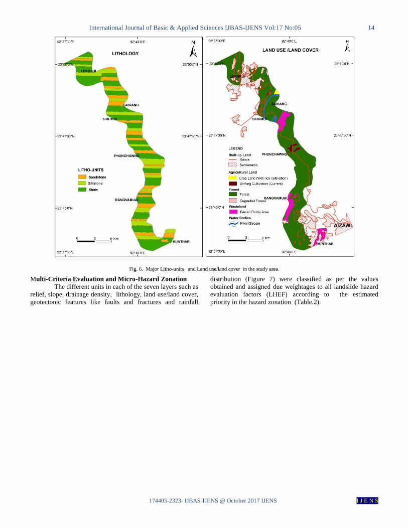
Lithology
The area is composed of sedimentary rocks of sandstones,
siltstones and shales in alternate successions in its regional
geological set-up. The thickness of these units, vary at places
from a few centimeters to several meters (Table.1 and Plate 1).
Most of area along this road except the southern parts of
Lengpui airport is dominated by sandstone–siltstone/shale
intercalation which is prominently jointed in sets which shows
different patterns of lithology and structures. The thickness of
rock exposures at Hunthar Veng is 24 m which decreases up
to 5 m at nearly 11 km from station 1 (Table 1). The
thickness of the exposure is about 93 m at Phunchawng (8.1
km from station 1). At several places along this 45 km long
road section the rock exposures of about 60 to 100 m thick
are found. After the Phunchawng locality (12 km from
station 1), the thickness of exposures range from 5 m to a
maximun of 24 m (at 8.3 m from station 1),where massive
sandstones with huge joints are exposed. The dominent
lithology of sandstone, shale and siltstone intercalation all
along the road section shows varying dips with the minimum
of 27o is recorded at Shihmui (22.4 km) and the maximun of
56o at Phunchawng localitiy (12 km from Station.1). The
strata at many locations is intersected by cross-cut high angle
and sub vertical joints with joint angles varying from 57o to
85o. Some joints with lower angle are found ranging between
18o and 42o. A majority of the joints are dip type. Many parts
of the road sections have mild to intense shears. The regional
dip is westward with some local variations (Figure 2). The
beds dip from moderate to quite steeper gradients (27 o - 56o).
The joints are mostly high dipping varying from more than 50o
and exhibit almost sub vertical trends.

International Journal of Basic & Applied Sciences IJBAS-IJENS Vol:17 No:05 12
174405-2323- IJBAS-IJENS @ October 2017 IJENS I J E N S
Source: Field Survey (2016-2017)
Rainfall
The area receives an average annual rainfall of about
2500 mm. The area towards the Aizawl city receives more
than 2500 mm of rainfall and the area beyond Sihhmui and
Sairang up to Lengpui airport receives less than 2500 mm
of rainfall (Figure 5). As a whole, rainfall decreases towards
the plain area where Lengpui airport is located.
Land Use/ Land Cover
Land use and land cover is also one of the
determining factors in landslide evaluation. Built-up areas
with settlements are most distressed by landslides as they are
compact. Most of the area is covered by dense forest except a
few patches of degraded forest particularly at Lengpui
airport. Settlements are located along the road in a linear
form except the major settlements like Aizawl city and
Lengpui airport which are compact (Figure 6). Except
Lengpui all other settlements are located over steep slopes
Table I Field Data Sheet of the Study Section (Hunthar-Lengpui Road).

International Journal of Basic & Applied Sciences IJBAS-IJENS Vol:17 No:05 13
174405-2323- IJBAS-IJENS @ October 2017 IJENS I J E N S
exceeding more than 45o. Wet-rice cultivation is practiced
only in medium extent of 1 km2 only in and around Sairang
village mostly along the left bank of the river Tlawng
whereas a small extent of 0.30km2 area of shifting cultivation
is found at Phunchawng village. Exposed barren rocky areas
are seen all along the entire 45 km long road section.
Fig. 4. Drainage density and Geotectonic features in the study area.
Fig. 5. Rainfall Distribution in the study area.
International Journal of Basic & Applied Sciences IJBAS-IJENS Vol:17 No:05 14
174405-2323- IJBAS-IJENS @ October 2017 IJENS I J E N S
Fig. 6. Major Litho-units and Land use/land cover in the study area.
Multi-Criteria Evaluation and Micro-Hazard Zonation
The different units in each of the seven layers such as
relief, slope, drainage density, lithology, land use/land cover,
geotectonic features like faults and fractures and rainfall
distribution (Figure 7) were classified as per the values
obtained and assigned due weightages to all landslide hazard
evaluation factors (LHEF) according to the estimated
priority in the hazard zonation (Table.2).

International Journal of Basic & Applied Sciences IJBAS-IJENS Vol:17 No:05 15
174405-2323- IJBAS-IJENS @ October 2017 IJENS I J E N S
Table II
Weightages of Landslide Hazard Factors.

International Journal of Basic & Applied Sciences IJBAS-IJENS Vol:17 No:05 16
174405-2323- IJBAS-IJENS @ October 2017 IJENS I J E N S
Fig. 7. Micro Landslide Hazard Zonation Map of the study area.
The thematic layers, thus generated have been
rasterized for validation using raster calculator. All the raster
layers have been reclassified and assigned thematic weights
as fixed with the help of 3D analyst module to generate final
landslide hazard zonation map. The thematic layers have been
multiplied with the corresponding predetermined thematic
weights for their integration as shown here.
([Relief*0.15] + [Slope*0.20] + [Geotectonic features*0.10]
+ [Drainage density*0.15] + [Lithology*0.15] + [Land use
*0.15] = [Rainfall*0.10])
Based on the multi-criteria analyses of various
causative factors, the micro-landslide hazard zonation map of
the area has been prepared. The map shows five distinct
classes of intensity of landslide hazards such as very high,
high, moderate, low and very low along the study section
(Figure 7). The road section from Hunthar Veng to
Rangvamual and Phunchawng falls under ‘very high to
moderate hazard zone’.
The severity in this section reflects the adverse
impact of dense urbanization on the waning slopes due to
improper sewerage and practically uncontrolled and
unmonitored constructions. Similarly, the section between
Phunchawng to Sairang is relatively less hazardous which
reflects the reduced load of urbanization as this part has less
density of human settlements. The remaining part of the road
section of Sairang-Sihhmui-Lengpui is relatively safer as the
zone is falling in ‘very low-low-moderate hazard’. However,
the section around locally known as ‘elephant rock’ (Plate 2)
is a very high hazard zone due to presence of huge jointed
blocks of massive sandstones with the overlying shales. As a
whole there are 9 prominent landslide hazard zones of various
intensities have been identified along the study section
(Plate 3).

International Journal of Basic & Applied Sciences IJBAS-IJENS Vol:17 No:05 17
174405-2323- IJBAS-IJENS @ October 2017 IJENS I J E N S
CONCLUSION
The study is first of its kind to generate large scale
micro-hazard zonation map of the road section between
Aizawl city and Lengpui airport. The map shows five distinct
classless of landslide hazard zones. The road section from
Hunthar Veng to Rangvamual and Phunchawng falls under
very high-high-moderate hazard zones mostly due to dense
urbanization on the waning slopes as there is no proper
sewerage and no monitor of heavily loaded constructions. The
road section between Phunchawng to Sairang is relatively less
hazardous as there is relatively less urbanization. Similarly,
the road section of Sairang-Sihhmui-Lengpui is relatively
safer as the zone is falling in ‘very low-low-moderate hazard’
due to less topographic elevation. The area needs proper
monitoring for construction of heavily loaded structures over
precipitous slopes to mitigate the intensity of landslides
thereby to reduce the risk of damage.
ACKNOWLEDGEMENTS
The authors are thankful to Department of Science
and Technology, Govt. of India, New Delhi for providing
financial assistance by granting a major research project to
conduct the present study. The second author is thankful to the
Principal, Pachhunga University College, Aizawl, for
providing necessary facilities to carry out this work.
REFERENCES [1] Acho-Chi. (1998), Human interference and environmental
instability: addressing the environmental consequences of rapid
urban growth in Bamenda, Cameroon. Environment and Urbanization, 10 (2), pp 161-174.
[2] Bureau of Indian Standard (1998), Indian standard: preparation of
landslide hazard zonation maps in mountainous terrain; Guidelines Part.2: Micro Zonation, 17 p.
[3] Ganju, J.L. (1975), Evolution of orogenic belts of India.
Geological Mineralogical Meteorological Society of India, 4, pp 17-26.
[4] Manik Das, A., Sankar Kumar, N. and Soumay Kanti, M. (2011),
Landslide hazard and risk analysis in India at a regional scale. Disaster Advances, 4 (2), pp 26-39.
[5] Prabhin Kayastha, Megh Raj Dhital, and Flormond De Smedt.
(2013), Evaluation and comparison of GIS based landslide
susceptibility mapping procedures in Kulekhani water shed, Nepal.
Journal of Geological Society of India, 8, pp 219-231.
[6] Singh, Y., Bhat, G.M., Vinay Sharma, Pandita, S.K and Thakur,
K.K. (2012), Reservoir induced landslide at Assar, Jammu and
Kashmir: A Case Study. Journal of Geological Society of India, 80, pp 435-439.
[7] Tiwari, R.P., Sharma, B.L. and Singh, B. (1996), Geotechnical
appraisal of Bawngkawn landslide, Aizawl, Mizoram, Proceedings of International Conference on Disaster Mitigation, Madras
1(A):A4, pp 125-131.
[8] Tiwari, R.P., Lanuntluanga,F., Kachhara, R.P. and Singh, B.(1996), Landslide hazard zonation along Hrangchalkawn-
Roltlang road section, Lunglei, Mizoram, Journal of Engineering
Geology, XXV(1-4), pp 257-269. [9] Tiwari, R.P. and Kumar, S. (1997), South Hlimen landslide in
Mizoram-A pointer, Envis Bulletin Himalayan Ecology &
Development, 5(2), pp 12-13. [10] Tiwari, R.P., Lannuntluanga, F. and Kachhara, R.P. (1998),
Landslide hazard zonation- A case study along Hnathial-
Hrangchalkawn road section, Proceedings of International Conference on Disaster Management, Tejpur, pp 461-478.
[11] Tiwari, R.P., Lannuntluanga,F. and Kachhara, R.P (2001),
Landslide hazard zonation along north Tawipui-Thingfal road section, Lunglei district, Mizoram, Pre-Seminar volume of
National Seminar on Geotechnical & Geological Hazards in the
Indian Context. Jour. Geological Survey of India, Shillong, pp 231-226.
[12] Udayabhaskararao, Ch. (2014), Topographic changes in Aizawl city and its surroundings during 1973-2013: A digital terrain
analysis through remote sensing and GIS techniques. Geographic,
9, pp 19-26. [13] Verma, R. (2013). Landslide hazard in Aizawl Township,
Mizoram" in Edited Vol. Landslides and Environmental
Degradation in Hilly Terrains. Editor. R.A.Singh, ISBN. No. 81085097-90-9 Gyanodaya Publication, Nanital, Uttarakhand, pp
11-21.
[14] Verma, R. (2014). Ngaizel Landslide, Aizawl, Mizoram, India: A Case of Wedge Failure; Asian Academic Research Journal, Vol.1,
Issue.22, June 2014, ISSN.2319-2801, pp. 422-429.
[15] Verma, R. (2014). Landslide Hazard in Mizoram: Case Study of Laipuitlang Landslide, Aizawl. International Journal of Science
and Research (IJSR), ISSN (Online): 2319-7064, Impact Factor
(2012): 3.358; June 2014. [16] Zhou, G., Esaki, T., Mithani., Y., Xie, M. and Mori, J. (2003),
Spatial probabilistic modeling of slope failure using an integrated
GIS Monte Carlo simulation approach. Engineering Geology, 68, pp 373-386.

International Journal of Basic & Applied Sciences IJBAS-IJENS Vol:17 No:05 18
174405-2323- IJBAS-IJENS @ October 2017 IJENS I J E N S
PLATE-1
PLATE-2
About 11 metres thick huge jointed blocks of massive sandstone with overlying shales around locally called
‘elephant rock’ at about 24 km from Aziawl city.
Sandstone–shale intercalations at bottom and massive
sandstone at top within the 11 metres thick sandstone
unit at about 24.2 km from Aizawl city
Sub-vertical joints within the 6 metres thick
sandstone at 12.3 km from Aizawl city.

International Journal of Basic & Applied Sciences IJBAS-IJENS Vol:17 No:05 19
174405-2323- IJBAS-IJENS @ October 2017 IJENS I J E N S
PLATE-3
The prominent Landslides between Aizawl city and Lengpui Airport.