Embed Size (px)
Citation preview

Manual Prepared by:
The Center for Technology & Training (CTT)
Michigan Technological University
Revised: February 2014

i
Table of Contents
Introduction ........................................................................................................................................................ 1
Michigan’s Regional Planning Organizations .......................................................................................... 2
Michigan’s Metropolitan Planning Organizations .................................................................................... 3
New Midland Area Transportation Study (MATS) Boundary ................................................................. 4
Section 1: Data Collection Requirements .......................................................................................................... 5
PASER data collection regulations ............................................................................................................... 5
Roads that must be rated .......................................................................................................................... 5
Definition of “Federal-aid eligible” .......................................................................................................... 5
Collection timeline ................................................................................................................................... 6
Rating teams ............................................................................................................................................. 6
Required training sessions ........................................................................................................................ 6
Reimbursement ......................................................................................................................................... 6
Quality control .......................................................................................................................................... 7
Rating roads effectively ................................................................................................................................ 7
Rating speed ............................................................................................................................................. 7
Rate distress, not ride quality ................................................................................................................... 7
Measuring rutting ..................................................................................................................................... 7
Group dynamics ....................................................................................................................................... 7
Lighting conditions................................................................................................................................... 7
Inclement weather .................................................................................................................................... 8
Boundary segments .................................................................................................................................. 8
Basic pavement information ..................................................................................................................... 8
Selecting the lane to rate .......................................................................................................................... 9
Road use or importance does not influence rating .................................................................................... 9
Dealing with road construction projects ................................................................................................... 9
Rate what you see ..................................................................................................................................... 9
Light-colored pavement ........................................................................................................................... 9
Paved shoulders ........................................................................................................................................ 9
Data management .......................................................................................................................................... 9
Working with smaller cities and villages ................................................................................................. 9
Splitting segments .................................................................................................................................. 10
Errors in the framework map .................................................................................................................. 10
Safety concerns ........................................................................................................................................... 10
General safety ......................................................................................................................................... 10
Seating within the vehicle ...................................................................................................................... 11
Replacement vehicles ............................................................................................................................. 11
Computer hardware ................................................................................................................................ 11
Section 2: Data Collection Procedure .............................................................................................................. 12

ii
Step 1: Identify your TAMC network for data collection ........................................................................... 13
Step 2: Export the TAMC network for use with the LD ............................................................................. 14
Step 3: Send a copy of the TAMC network to the CSS .............................................................................. 15
Step 4: Import the network into the LDC .................................................................................................... 16
Step 5: Connect the GPS to your laptop and begin collecting data ............................................................. 17
Connect the GPS .................................................................................................................................... 17
Collect data ............................................................................................................................................. 17
Scenario A: Agencies that must define their Federal-Aid Network Unpaved Road Network inventory 18
Scenario B: Agencies that have already defined their Unpaved Road Network inventory .................... 19
Step 6: Export collected data from the LDC ............................................................................................... 22
Step 7: Import the collected data to Roadsoft ............................................................................................. 23
Step 8: Export Roadsoft asset management data for the regional version of Roadsoft ............................... 24
Step 9: Import Roadsoft asset management data from the local agency into the regional version of
Roadsoft ...................................................................................................................................................... 25
Step 10: Export shape file and submit to the TAMC .................................................................................. 26
Section 3: Sealcoat Road Rating Guide ........................................................................................................... 28
Using the “Percentage” approach ................................................................................................................ 28
Michigan PASER Sealcoat Rating Guide Table ......................................................................................... 29
Section 4: Splitting Segments .......................................................................................................................... 30
Guiding principles for splitting segments ................................................................................................... 30
Good reasons for splitting segments ........................................................................................................... 30
Bad reasons for splitting segments .............................................................................................................. 30
Section 5: PASER Data Quality Control Guide ............................................................................................... 32
Step 1: Determine the total length of your network .................................................................................... 32
Step 2: Determine the total length of paved segments in your network ...................................................... 32
Step 3: Verify that your agency’s TAMC data are accurate ....................................................................... 33
Table of quality control queries .................................................................................................................. 33
Appendix A – PASER Certification/Training Requirement policy ................................................................. 34
Appendix B – Data Collection Timesheet ....................................................................................................... 37
Appendix C – Framework Error Form ............................................................................................................. 38

1
The Pavement Surface Evaluation and Rating (PASER) system is a visual survey method for
evaluating the condition of roads. The method was developed by the University of Wisconsin
Transportation Information Center to provide a simple, efficient, and consistent method for
evaluating road condition. Michigan’s Transportation Asset Management Council (TAMC) has
adopted the PASER system for measuring statewide pavement conditions in Michigan.
Part of the TAMC’s mission is to obtain accurate PASER ratings that provide a clear view of the
condition of the road network in Michigan. The TAMC uses these ratings to communicate the
condition of Michigan roads to the Michigan Legislature. At the local level, this data serves as
the foundation on which to build cost-effective pavement maintenance strategies.
The TAMC chose Roadsoft—a roadway management system for collecting, storing and
analyzing data—for use in developing its statewide pavement rating collection strategy. Roadsoft
is funded through the Michigan Department of Transportation (MDOT) and developed,
supported, and distributed by Michigan Technological University’s Center for Technology &
Training (CTT).
The TAMC also works in conjunction with Michigan’s Regional/Metropolitan Planning
Organizations (RPO/MPO) to collect PASER data. Although these regional organizations
operate under many different names and serve a variety of different areas, they all participate in
coordinating and performing PASER data collection.
This manual describes the requirements and processes involved in collecting PASER data for the
TAMC in conjunction with the RPO/MPOs. It also includes information on how to split
segments, rate sealcoats, and double-check collected PASER ratings in Roadsoft.

2
Michigan’s Regional Planning Organizations

3
Michigan’s Metropolitan Planning Organizations

4
New Midland Area Transportation Study (MATS) Boundary

5
PASER data collection regulations
According to Act 51 (P.A. 499 2002, P.A. 199 2007) each local road agency shall annually
report the mileage and condition of the road and bridge system under their jurisdiction to the
TAMC. To fulfill the requirement of this Act each year the TAMC sets requirements for road
condition data collection and submission by road-owning agencies in Michigan.
Road condition rating is eligible for reimbursement from the TAMC if the required training is
attended and proper documentation is submitted at the end of the collection process.
Roads that must be rated
At least 50% of Federal-aid eligible, paved roads must be rated. There are three categories of
data required for each rated road with a paved surface:
1. Surface Type
2. PASER Rating
3. Number of Lanes
Unpaved road inventory (surface type only) should be collected for unpaved roads in the
Federal-aid eligible system. Unpaved inventory collection on the non-federal aid system will not
be reimbursed at this time. Collection teams will collect all information on unpaved road types
(unimproved earth and gravel to be classified at the local agency’s discrepancy) within their 50%
of the Federal-aid eligible network for collection each year. Based on current estimates, unpaved
roads should be approximately 4% of the Federal-aid system.
Definition of “Federal-aid eligible”
For the TAMC PASER data collection there has been a change in what constitutes a “Federal-aid
eligible” road. This change excludes some Rural Minor Collectors that that were rated during
previous years.
According to 23 USC § 101, “Federal-aid eligible” roads are “highways on the Federal-aid
highway systems and all other public roads not classified as local roads or rural minor
collectors.” This definition can be stated in terms of NFC class, where NFC = 1, 2, 3, 4, 5, and 6
where one or both sides of the road on or in an urban boundary (RU_L > 1 or RU_R > 1). NFC
codes are defined as follows:
1 – Interstates
2 – Other Freeways
3 – Other Principal Arterials
4 – Minor Arterials
5 – Major Collectors
6 – Minor Collectors
7 – Local
0 or uncoded – not a certified public road
RU_L | 1 Rural/Urban designation left

6
RU_R | 1 Rural/Urban designation right
1 – Rural area
2 – Small urban area (5,000 to 49,000)
3 – Small urbanized area (50,000 to 199,999)
4 – Large urbanized area (200,000 or more
For paved Federal-aid data collection the council collects PASER data based on the above
definition of “Federal-aid eligible”, so you will not be collecting PASER data on Rural Minor
Collectors. Using the current Roadsoft query of “Federal Aid = True” will take this change into
account and give you the correct network conforming to the new definition.
Collection timeline
Data collection begins: April 1, 2014
Data collection completed by: November 28, 2014
Data submitted to the Center for Shared Solutions (CSS) by: December 6, 2014
Rating teams
Teams should be comprised of one member from MDOT, one member from the Act-51
jurisdiction’s RPO/MPO and one member from the jurisdiction being rated (County, City, or
Village).
To schedule your PASER data collection, contact your RPO or MPO. See the maps on pages
two, three, and four to determine the regional planning office that your jurisdiction falls under.
See http://miregions.com/michigan-planning-regions/ if you need contact information for an
RPO or MPO.
Required training sessions
Anyone who participates in the annual PASER condition data collection of the federal-aid
system and influences the rating activity must attend on site PASER training in the same year the
data collection occurs. New raters and seasoned raters who did not attend PASER training the
year prior must attend one supplemental PASER webinar session in addition to attending one on-
site session.
The TAMC has instituted a testing and certification program for PASER data collectors who
attended TAMC PASER training and collected PASER data for multiple years. The certification
allows experienced raters to opt out of training in future years. The full certification/training
requirement policy is attached as Appendix A of this document.
Reimbursement
Data collection for federal aid is reimbursable for qualified individuals. Non-Federal-aid
collection reimbursement can be given if previously approved by the TAMC coordinator.
Requests for approval to collect non-Federal-aid data for reimbursement and invoices for rating
efforts (see Appendix B) should be submitted through your RPO/ MPO to:
Brian Sanada
Michigan Department of Transportation

7
PO Box 30050
425 W. Ottawa St.
Lansing, MI 48909
Quality control
The RPO or MPO coordinating PASER collection must review the collected data before sending
it to the CSS. This quality control procedure is described in detail in Section 5.
Rating roads effectively
Rating speed
Rating roads at high speeds can cause inaccuracy. Reviews conducted by the CTT’s PASER
trainers have shown that teams that view roadways at lower speeds are much more likely to rate
them accurately. Rating roads at high speed can cause distresses to be missed and result in higher
than appropriate ratings.
Rate distress, not ride quality
Just because a road rides well doesn’t mean that it doesn’t have distress in need of Capital
Preventative Maintenance (CPM) or Structural Improvement (SI). This is especially true on a
road with rutting and cracking in the wheel path, both of which can cause rapid deterioration.
Conversely, an asphalt surface in relatively good condition, with sealed longitudinal cracks,
often makes quite a bit of noise as tires pass over the expanded crack seal. More noise does not
always mean severe distress. Don’t let ride quality distort your ratings.
Measuring rutting
It can be difficult to detect rutting when moving at high speeds on a sunny day. To help avoid
incorrect rutting assessments, each regional office is provided with a 6-foot aluminum T-bar. By
using the bar in conjunction with a tape measure, teams can quickly get a tangible assessment of
the extent of rutting on a road where it is practical and safe to do so. It’s the rating team’s
decision to choose whether or not to physically measure rutting.
Group dynamics
Teams need to be aware of group dynamics in their vehicles. Condition rating is supposed to be a
group process. However, the process also needs to conform to PASER procedure. Teams should
read the PASER descriptions closely and refer to the laminated reference sheets for clarification.
Lighting conditions
Changes in lighting conditions and the time of day can influence how some distresses are
perceived. Bright sunlight directly overhead may make surface texture defects or fine cracking
hard to discern. Rating early in the morning or late in the afternoon on a sunny day while driving
into the sun may also make it difficult to rate roads effectively. If lighting conditions are poor,
slow down or stop to make sure that you are not overlooking any visual cues.

8
Trees cause many shadows that can appear to be road distresses. Tree shadows on the road make
for very difficult rating conditions. Options are to return to the location at a different time or
drive at lower speeds.
Inclement weather
PASER is a visual assessment system. Trying to rate pavement in the rain is ineffective. Road
surfaces look different when they are wet—cracks look larger, puddles can hide distresses, etc.
Teams should not rate roads when they are wet.
Boundary segments
Boundary roads (roads that fall between jurisdictions) often have non-standard characteristics
and splits on the Roadsoft map. As a result, it may be unclear which jurisdiction is responsible
for rating a boundary road.
To eliminate potential data collection issues when rating boundary roads, follow these two rules:
Rule 1: Follow the Collection Procedure (Section 2) carefully
The steps for collecting and submitting TAMC data are laid out in a specific order to prevent
rated roads from being overwritten by unrated roads. If you deviate from the documented
procedure, some of your rating data may be overwritten by unrated roads.
Rule 2: Rate all boundary roads in your network
Rating teams should rate all boundary roads in their data collection networks, regardless of
ownership or maintenance responsibilities.
Basic pavement information
The three main PASER manuals used by Michigan are for asphalt, concrete, and sealcoat. The
PASER manual for brick is also used, as brick is reported but not widely taught. Hot mix asphalt
is a structural pavement type. Generally a structural hot mix asphalt layer has a thickness of 1.5”
or more.
A composite pavement is an old concrete pavement that has asphalt overlay. Composite
pavements should be rated with the asphalt rating system, but be inventoried as a composite
pavement.
A chip seal or a sealcoat on top of an asphalt pavement is not considered a sealcoat pavement
because the asphalt below is considered the structural layer. This pavement should be rated with
the asphalt rating system.
A sealcoat pavement is an unpaved road with a sealcoat (chip seal) surface treatment. There is no
full-width structural layer of asphalt in a sealcoat pavement. This pavement should be rated with
the modified Michigan sealcoat rating system, which uses a 1-10 scale.
The rating scale in the Brick & Block PASER manual is 1, 2, 3, 4. To be consistent with other
pavement rating scales the brick and block scale must be doubled resulting in 2, 4, 6, 8 ratings
while maintaining the original definitions from the manual. A rating of 10 would be reserved for
brick and block pavements that are in a very good condition and less than one year old.

9
Selecting the lane to rate
If there is a difference in quality, rate the worst lane.
Road use or importance does not influence rating
Don’t rate an ‘important’ road less than the actual PASER rating. This is confusing a
management decision with rating. Road ownership/use or “importance” does not change its
distress rating.
Dealing with road construction projects
For rating an under construction road If the old pavement is gone, the road should be rated as if
the construction were complete. If the existing pavement is still there, rate what you see.
Rate what you see
Don’t anticipate the next PASER rating based previous PASER data. Rate what you see. The
value of the existing data is that there is a usable record of road improvements and ratings, costs,
and extended life.
Light-colored pavement
Oxidized pavements can be very light and often look gray or off-white, which causes distresses
to be less visible. Flat lighting on an oxidized pavement can also hinder visibility of distresses.
Paved shoulders
For paved shoulders, rate the pavement from edge line to edge line and omit the shoulder
condition. Shoulders are not rated because they are constructed differently than the traveled way;
there is not typically a structural layer in a shoulder so deterioration is different.
Data management
The data collection process needs to start with the local agency’s Roadsoft data set, not with an
RPO or MPO’s version of Roadsoft. Collection teams should use local data – not regional data –
as a starting point. For 2014 PASER collection you will need to update to Roadsoft and LDC
versions 7.7 or newer (available by April 1).
Note that changes to data will only be sent to TAMC if they were collected in the LDC or hand
entered in the region version of Roadsoft. Rating and changes in ratings should be initially
entered in the LDC (not in Roadsoft) or data will not be reported.
Working with smaller cities and villages
Smaller cities and villages are often enthusiastic about the data collection process. However, it
can be time-consuming to visit smaller communities (10 or 20 miles of Federal-aid eligible
roads) in order to set up a Roadsoft network. If an agency has a limited number of miles in their
jurisdiction there are a few options for including them in the data collection process.
In version 7.7 or later of Roadsoft and the LDC, data collection exports from the LDC can be
provided to small agencies as a means for transferring recently collected PASER data that was
collected using an export from the county version of Roadsoft. This option should only be used

10
for small cities and villages with their permission, because the historical road splits and historical
data present in the small local agencies’ Roadsoft database will not be available to assist in
collection activities. Medium to larger cities and villages that use Roadsoft should be collected
using an export from the agency’s version of Roadsoft as you would with a county.
Another option for dealing with very small agencies it to provide them with a report (PASER
rating by PR segment) and have them manually enter data in their version of Roadsoft.
Both of these options allow data collectors to use the collection networks they build at their road
commission without having to stop and upload data for these small agencies. Data collection
should be dealt with on a case-by-case basis.
Splitting segments
If a team encounters an undocumented change in the surface type or layout of a road (such as
number of lanes) they should create a split in the Roadsoft map to reflect the change. Detailed
guidelines for creating splits can be found in Section 4.
Errors in the framework map
If a team suspects that they have discovered an error in their jurisdiction’s map, they should first
place a short notation in the Laptop Data Collector (LDC) memo field for that segment.
Consistent use of a tag such as “error” can simplify creating a Roadsoft report containing these
errors and the segments that they are located on. This information can be passed on to the CSS
for correction.
Next, a team should fill out the Asset Management Change Request for Michigan Geographic
Framework (Appendix B) and submit it to:
Joshua L. Ross
Michigan Center for Shared Solutions
Romney Building, 10th Floor
111 S. Capital Ave.
Lansing, MI 48033
You can also request changes by contacting Mr. Ross at (517) 373-7910.
Safety concerns
General safety
During data collection, you will be merging in and out of traffic, slowing down, pulling off to the
shoulder for team discussions, etc.—always take safety precautions. Driving the team vehicle is
not something to be taken lightly. All the vehicles must be equipped with a warning light bar.
Warning garments should be worn by raters that get out of the vehicle to better view distress or
measure rutting. Above all, be sure to comply with your employer’s warning garment
requirements.

11
Seating within the vehicle
The best configuration for a 3-person team is the driver and rater in the front seats, and the data
entry person in the back seat. If the data entry person sits in the front seat with a laptop, they
could be injured by an airbag discharge.
Replacement vehicles
If you need another vehicle, either use one from the county road commission or rent one. If you
need to rent a vehicle, the MDOT rater should sign the rental agreement and purchase the extra
insurance.
Computer hardware
Data collection teams are provided a laptop computer and a GPS by their RPO/MPO, but it is
best to have a second laptop in the vehicle just in case something goes wrong. Many county road
commissions and cities now have laptop computers; consider using them as backup.

12
Before you begin collecting road data for the TAMC, ensure you are using Roadsoft and Laptop
Data Collector Version 7.7 for the 2014 data collection season (released by April 2014).
Visit www.roadsoft.org/Downloads for Roadsoft updates.
If you have any questions or concerns, please call Roadsoft support at 906-487-2102.

13
Step 1: Identify your TAMC network for data collection
Make sure you are using the local agency’s copy of Roadsoft at the road commission, city, or
village for which you will be collecting data. The decision of how to develop a TAMC network
is being left up to agencies and Regional Coordinators. Remember that networks must include at
least 50% of paved Federal-aid eligible roads that were not collected in the previous year, as well
as 50% of your unpaved Federal-aid roads.
Your 2014 TAMC network1 will be based on the network that you rated in 2012, but include
unpaved Federal-aid roads (gravel, earth and undefined).
To begin, add a map filter to show only Federal-aid roads.
1. Under Map Layers, make sure the Road layer is selected. Right-click the map and select
Network/Filter Builder.
2. Add a criterion of Federal Aid as the Field, Equals as the Operator, and True as the
Value.
3. Save this network, and then click Apply as Map Filter.
Next, apply your 2012 TAMC network as a selection.
4. Reopen the Network Filter Builder. Click the Open button, select your saved TAMC
network from 2012, and click the OK button.
5. Click Apply as Selection.
6. By examining your 2012 TAMC network, determine a rough polygon of the area that you
rated in 2012.
7. Make sure that your Selection Mode is in “Select by Framework Segment”. Using
shift+left-click, drag your mouse over the unselected roads in the polygonal area so that
they are added to the selection.
Note: Add multiple road segments to your selection by dragging shift+left-click or ctrl+left-
click. Multiple selections can be removed by dragging alt+left-click.
1 If you are collecting data for a non-Federal-aid project that TAMC has approved for reimbursement, use the
approved network for Step 1. The rest of the steps for data collection (2-10) will follow the same procedure.

14
Step 2: Export the TAMC network for use with the LDC
1. Open the TAMC menu from the Roadsoft menu bar. Select 1 - (County/City Does This)
Export Data for LDC.
2. Click Choose Network, and then click Edit. Select your TAMC network from the drop
down list. The network you want is the one you saved at the end of your appropriate
scenario in Step 1.
3. Define an Export Path; this is the location on your hard drive where you want to save the
export file.
4. Save the export file to the location you specified by clicking the Export button.
5. Click OK to close the window confirming a successful export.
6. Roadsoft creates two files in the location you specified:
RStoLDC_[jurisdiction]_[date]_[time].ldcz
RStoLDC_[jurisdiction]_[date]_[time].zip
For the purposes of 50% network reporting, you will be sending the .zip file to TAMC
7. Copy the .ldcz file to a CD, flash drive, or other portable storage device so you can
transfer it onto the laptop that has the LDC installed on it.

15
Step 3: Send a copy of the TAMC network to the CSS
Your agency should submit a copy of the exported TAMC network to the CSS before beginning
data collection.
1. Open your web browser and go to:
http://www.mcgi.state.mi.us/mitrp/Council/Default_Council.aspx
2. Click the Investment Reporting tab at the top of the page and select Data.
3. Log in using your user ID and password.
4. Select the Send Data sub-tab.
5. Choose the Other File button
6. Select your jurisdiction from the dropdown menu.
7. Click the Choose file button to attach the .zip file you created in Step 2.
8. Click the Upload button to submit the data to the TAMC.

16
Step 4: Import the network into the LDC
1. Insert the portable storage device that contains the export file from the local agency.
2. Start the LDC. You will be prompted to select a database (DB) and Crew name (the name
of the person(s) rating.
3. Click the button to locate the export file on the portable storage device.
NOTE: If you want to change your database while inside the LDC, select the File menu, then
click Change DB (Import Data from Roadsoft).
Tim Colling

17
Step 5: Connect the GPS to your laptop and begin collecting data
Connect the GPS
1. Start the LDC.
2. With your GPS device turned off, connect it to your laptop using the Serial or USB
connection.
NOTE: If your GPS is on before connecting it, your mouse pointer may jump around erratically.
If this happens, turn off your GPS, leave it connected, and restart windows and the LDC.
3. Turn on your GPS and wait for it to acquire a position (this could take a couple of
minutes).
4. From the LDC main menu open the GPS menu and select Connect to establish
communication between the GPS and the LDC. Wait a few minutes for the software to
snap to the GPS position on the GIS map. If your GPS fails to connect, wait several
minutes and try to connect again, or contact Roadsoft support.
NOTE: If you’re not on or near a road segment that is part of the network that you imported into
the LDC, the LDC will not snap to a segment on the map. Drive your vehicle toward a road that
is part of the network so that the vehicle marker can snap to it. If this does not happen, restart
the LDC or call Roadsoft support.
Collect data
Use the following shortcut keys to enter data into the LDC:
Ctrl + S Surface Type
Ctrl + 0–9 PASER Rating
Shift + Ctrl + 0–9 Number of Lanes
Ctrl + Enter Submit (save) Data
Ctrl + +/- Zoom In/Out
Ctrl + Arrow Keys Pan the GIS Map
Ctrl + Space Bar Hold/Release Segment
For a complete list of shortcut keys, open the Help menu and select Shortcut Keys.
IMPORTANT: While collecting data, back up every hour or as often as conveniently possible.
From the main LDC menu select the File menu, then Backup Database to back up your data. If
data collection spans multiple days, export the data every day and save a copy of the data file
(LDCtoRS_ [date]_[time].ldc2rs) to a CD, jump drive, or floppy disk.
TIP: The History tab provides a history of PASER ratings for the current segment. Viewing past
PASER ratings before rating a segment can influence the rating. To avoid possibly influencing
the current rating based on past ratings, this grid will not be visible until you submit a rating for
the segment.

18
5. To complete the data collection process, verify that there are no unrated roads in your
TAMC network: To do so: click the File menu.
6. Select Current DB Statistics and verify that the Total Miles Not Yet Rated field displays
0. If the field is zero, skip step 7.
7. In the File menu, select Check for Unrated Segments to open the Unrated Segments
form. Highlight a row in the grid to select the segment on the map. Enter a rating for the
segment, then move to the next row in the grid. Continue entering ratings for each
segment until reaching the bottom of the grid. Click the Refresh to update the form.
When there are no more records in the grid, all segments have been rated.
8. Proceed to Step 6 once all the roads in your TAMC network are rated.
Scenario A: Agencies that must define their Federal-Aid Network Unpaved Road Network inventory
Teams must drive the non-paved roads segments on the Federal-aid system and verify the
pavement type on the road segment, if they have not done this already. Road segments that have
a surface type currently set as “Undefined” must be validated by changing the surface subtype to
the appropriate subtype. Then, click the Validate Surface Type button to save the data.

19
If the inventory data (start and end point of the segment) for the unpaved road segment are
already current, teams can click each individual unpaved segment (which will be colored orange)
in the LDC and click Validate Surface Type without having to drive the entire segment.
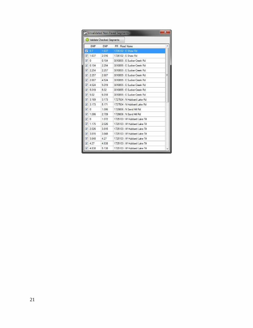
Scenario B: Agencies that have already defined their Unpaved Road Network inventory
If the inventory data (start and end point of the segment) for unpaved road segments are already
current and accurate, a tool to mass-validate these segments can be found in the File menu of the
LDC. Click the File menu and choose Check for Unvalidated Non-Paved Segment from the
drop-down menu.

20
Place a check next to each segment that will be validated using this tool. After checking all or
some segments, click the Validate Checked Segments button to submit an inventory validation
for the checked segments. All orange segments that are checked with this tool should now be
colored green on the map to indicate that they have been validated.
Please Note: Only agencies that have accurate unpaved-road inventories for the Federal-aid
system should use this tool.
21
22
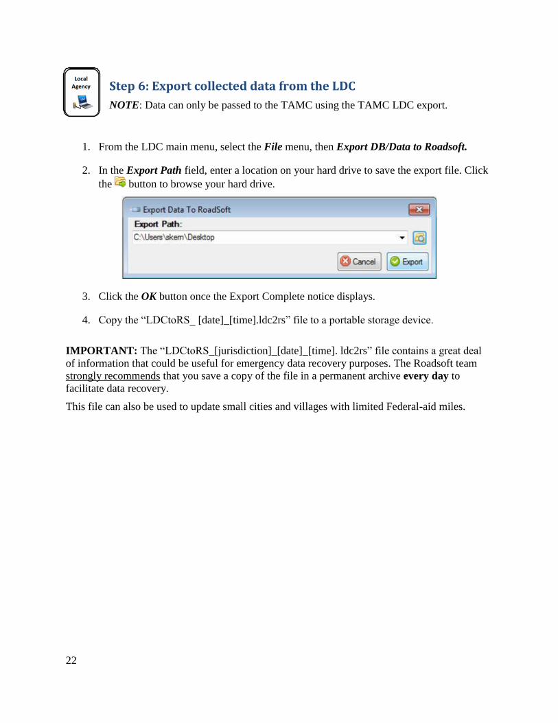
Step 6: Export collected data from the LDC
NOTE: Data can only be passed to the TAMC using the TAMC LDC export.
1. From the LDC main menu, select the File menu, then Export DB/Data to Roadsoft.
2. In the Export Path field, enter a location on your hard drive to save the export file. Click
the button to browse your hard drive.
3. Click the OK button once the Export Complete notice displays.
4. Copy the “LDCtoRS_ [date]_[time].ldc2rs” file to a portable storage device.
IMPORTANT: The “LDCtoRS_[jurisdiction]_[date]_[time]. ldc2rs” file contains a great deal
of information that could be useful for emergency data recovery purposes. The Roadsoft team
strongly recommends that you save a copy of the file in a permanent archive every day to
facilitate data recovery.
This file can also be used to update small cities and villages with limited Federal-aid miles.

23
Step 7: Import the collected data to Roadsoft
IMPORTANT: Before you import new data into Roadsoft, backup your existing Roadsoft
database. To do so, select the Tools menu, then Run Database Manager from the Roadsoft main
menu. Roadsoft has to shut down to run the Database Manager. You can restart Roadsoft after
backing up the data.
1. In the main Roadsoft window, open the TAMC menu and select 2 - (County/City Does
This) Import TAMC PASER Data from LDC.
2. If you haven’t already backed up your Roadsoft data, click the Yes button to open the
Roadsoft Database Manager and create a backup, then proceed with importing your
collected data. If you already backed up your data, click the No button to continue with
the import.
3. In the Import Data from LDC window, click the Browse for LDC Export button, and
then locate the “LDCtoRS_ [date].ldc2rs” file. When the import process is completed,
Roadsoft will automatically restart.

24
Step 8: Export Roadsoft asset management data for the regional version of Roadsoft
1. In the main Roadsoft window, open the TAMC menu and select 3 - (County/City Does
This) Export TAMC PASER Data to Region.
2. In the Export Path field, enter a location on your hard drive to save the export file. Click
the button to browse your hard drive.
3. Click OK when your export has been completed successfully.
4. Roadsoft creates a file named “TAMC_[jurisdiction]_[date]_[time].tamz” in the location
you specified. Copy this file to a portable storage device for import into the Region’s
version of Roadsoft.

25
Step 9: Import Roadsoft asset management data from the local agency into the regional version of Roadsoft
NOTE: This step is not performed in the field; it should be performed at the regional office to
import inspection data from individual agencies.
IMPORTANT: Before you import new data into Roadsoft, backup your existing Roadsoft
database. To do so, open the Tools menu and select Run Database Manager from the Roadsoft
main menu. Roadsoft has to shut down to run the database manager. You can restart Roadsoft
after backing up the data.
1. In the main Roadsoft window, open the TAMC menu and select 4 - (Region Does This)
Import TAMC PASER from County/City.
2. If you haven’t already backed up your Roadsoft data, click the Yes button to open the
Roadsoft Database Manager and create a backup, then proceed with importing your
collected data. If you already backed up your data, click the No button to continue with
the import.
3. In the Import Data from LDC window, click the Browse For File to Import button, and
then locate the “TAMC_[Jurisdiction]_[date].tamz” file. When the import process is
completed, Roadsoft will automatically restart.
NOTE: The Import Roadsoft Data screen lists the last four folders that you imported from. If
this is the first time you’re importing data, the screen will appear blank as above.

26
Step 10: Export shape file and submit to the TAMC
NOTE: Once your regional data are complete, export the regional shape file to the CSS.
1. To verify your regional data before proceeding, follow the steps in Section 3. 2. In the main Roadsoft window, open the TAMC menu and select 5 - (Region Does This)
Export TAMC Shape File to Council (Individual County Files).
NOTE: Do not use the standard Roadsoft Shapefile Export, as it is different than the TAMC
export.
3. Select the County you wish to export using the drop-down menu in the Export County
field.
4. In the Save Export Data to field, enter the name of the county you are exporting.

27
5. In the Shapefile Name field, enter the name of the county you are exporting local road
data for.
6. Click the Export button to export the data to a location on your hard drive.
7. Follow the guidelines in Step 3 to upload the exported file to TAMC through the CSS
Investment Reporting Tool (IRT). However, for this step you must choose the PASER
Data button rather than Other File button in Step 3-g.

28
The PASER rating system rates a sealcoat road (sealcoat over a gravel base) on a scale of 1 to 5.
However, the TAMC has decided to adopt a modified version of this rating system based on a 1
to 10 scale. This standardizes ratings so that all surface types in your TAMC network are rated
on the same scale. The Michigan PASER sealcoat scale is based on the relative percent of
distress observed in the pavement.
Using the “Percentage” approach
The sealcoat PASER system is based on the percentage of distress over a cross section of the
total length of the segment under consideration.
The distresses are:
edge distress
lane distress (including rutting)
raveling
These percentages are not cumulative.
Consider a cross section of the roadway segment; it can be 50 ft. long or 1 mile long. If neither of
the surface distress percentages outlined in the sealcoat rating chart exceed the upper limit of a
rating description, then that rating is your selection.
As another example: a sealcoat with a PASER of 5 allows up to 20% raveling, 20% edge distress
or 20% lane distress. If your assessment yields 10% raveling, 5% edge distress and 20% lane
distress, the PASER rating is 5 because neither of the distresses exceeds 20%. It is not a PASER
rating of 6 because lane distress exceeds the 10% criteria, and it is not a PASER rating of 4
regardless that the cumulative total distress equals 30%.
Consult the table on the following page for specific rating criteria.

29
Michigan PASER Sealcoat Rating Guide Table
PASER
Description Condition / defects Remedy / action
Typical
age in
years *
10 Excellent New construction None < 1 year
9 Excellent Like new None 1 to 3
8 Very good First signs of distress
Limited edge distress
Routine maintenance
Minor edge seal 3 to 5
7 Good
Minor distress
Edge distress with limited lane
distress <5%
Raveling < 5%
Minor asphalt or spray-injection
patching
Possible single application sealcoat
4 to 6
6 Good
Moderate distress
Edge distress up to 10%
Lane distress up to 10%
Raveling up to 10%
Moderate asphalt or spray-injection
patching
Single application sealcoat
5 to 7
5 Fair
Distressed
Edge distress up to 20%
Lane distress up to 20%
Raveling up to 20%
Moderate asphalt or spray-injection
patching
Single application sealcoat
With up to 50% double application
sealcoat
6 to 8
4 Fair
Edge distress up to 30%
Lane distress up to 30%
Rutting of ½” to 1”
Asphalt or spray-injection patching
and double application sealcoat 7 to 9
3 Poor
Edge distress up to 50%
Lane distress up to 50%
Rutting of 1” to 2”
Wedge and /or asphalt or spray-
injection patching and double or triple
application sealcoat
May be necessary to crush and
reshape prior to new sealcoat surface
8 to 10
2 Very poor
Edge distress > 50%
Lane distress > 50%
Rutting greater than 2”
Reconstruct by crush and shape prior
to new sealcoat surface, possible
return to gravel
> 9
1 Failed Extensive distress
> 50% of surface area
Reconstruct by crush and shape prior
to new sealcoat surface, or return to
gravel
>10
0 Not rated

30
The Roadsoft map initially splits all street and road segments on an intersection-to-intersection
basis (node to node) or by using Act 51 boundaries (township/city/county). Users can add road
segment splits to denote changes in surface types or conditions.
Rating teams should respect segment splits previously created by local agencies within Roadsoft.
The following sub-sections on splitting segments will help you decide if introducing new splits is
warranted, and how to introduce those new splits if necessary while collecting TAMC data.
Guiding principles for splitting segments
If the area in question has received rehabilitation or reconstruction separate from the
Framework segment from which it came, then the segment in question should be split
from the framework segment into its own designated rating segment.
Avoid splitting segments into lengths of less than ¼ mile.
Good reasons for splitting segments
Change in Surface Type
If the road surface changes from asphalt to gravel, asphalt to chip seal, chip seal to gravel, etc.,
then splitting a segment to reflect that change in surface type can ensure that the inventory
collected is representative of the actual road conditions.
Number of Lanes
Commercial or development activity may require the addition of through lanes or continuous left
turn lanes within a given framework segment. Splitting a segment to reflect this change will
ensure that Roadsoft’s lane mileage inventory reflects the true mileage accurately.
Intersection as a Unique Facility
Many intersections within a county/city system are extensions of segments, meaning their
design, surface type, service life, and number of lanes is no different than the segment they stem
from. However, some intersections have significant changes in surface type and/or geometry. In
these cases, it may be best to designate the intersection as a unique facility by making it a distinct
segment.
Environmental Factors
Environmental factors can have a significant impact on a segment of road. For example, regular
flooding or exceptional frost heave can cause severe damage to the roadway. Although this type
of deterioration is rare, if they are longer than a ¼ of a mile they should be designated as their
own segment so as to isolate the area needing rehabilitation or reconstruction.
Bad reasons for splitting segments
The following cases do not affect the network as a whole, and therefore do not warrant segment
splitting:

31
Change in PASER rating over a short stretch (Example 50 feet)
Short right or left turn bay
School zone
Traffic count segments

32
It is important to ensure that your PASER data are accurate and comprehensive. It is easiest to
check for errors in data at the local and regional levels before submitting data to the TAMC. Data
quality control can be performed by entering a series of queries into the Network/Filter Builder
in Roadsoft. The following steps will guide you through this process and ensure that your agency
has a complete set of PASER data.
Note that changes to data will only be sent to TAMC if they were collected in the LDC or hand-
entered in the region version of Roadsoft. Rating and changes in ratings should be initially
entered in the LDC (not in Roadsoft) or data will not be reported. Data entered into Roadsoft
rather than being collected in the field will result in missing data when the final collection file is
sent to the TAMC.
Step 1: Determine the total length of your network
a. Open the Network/Filter Builder either by right-clicking on the map and selecting
Network/Filter Builder, or by clicking on the map toolbar’s Filter button and selecting
Network/Filter Builder
b. In the Network/Filter Builder window, click the Open button to open the Select Network/Filter window.
c. Select your saved TAMC network for the current collection year and click the OK
button.
d. Look at the bottom left of the Network/Filter Builder window. Record the number of
Total Miles. You will use this number, along with
additional criteria, to verify that your regional PASER data
are correct.
Step 2: Determine the total length of paved segments in your network
a. Open the Network/Filter Builder either by right-clicking on the map and selecting
Network/Filter Builder, or by clicking on the map toolbar’s Filter button and selecting
Network/Filter Builder
b. In the Network/Filter Builder window, click the Open button to open the Select Network/Filter window.
c. Select your saved TAMC network for the current collection year and click the OK
button.
d. Add Criteria of Surface Type = Asphalt, Concrete, Seal Coat, Brick. Look at the bottom
left of the Network/Filter Builder window. Record the
number of Paved Miles. You will use this number, along
with additional criteria, to verify that your regional PASER
data are correct.
33
Step 3: Verify that your agency’s TAMC data are accurate
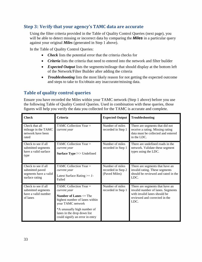
Using the filter criteria provided in the Table of Quality Control Queries (next page), you
will be able to detect missing or incorrect data by comparing the Miles in a particular query
against your original Miles (generated in Step 1 above).
In the Table of Quality Control Queries:
Check lists the potential error that the criteria checks for
Criteria lists the criteria that need to entered into the network and filter builder
Expected Output lists the segments/mileage that should display at the bottom left
of the Network/Filter Builder after adding the criteria
Troubleshooting lists the most likely reason for not getting the expected outcome
and steps to take to fix/obtain any inaccurate/missing data.
Table of quality control queries
Ensure you have recorded the Miles within your TAMC network (Step 1 above) before you use
the following Table of Quality Control Queries. Used in combination with these queries, those
figures will help you verify the data you collected for the TAMC is accurate and complete.
Check Criteria Expected Output Troubleshooting
Check that all
mileage in the TAMC
network have been
rated
TAMC Collection Year =
current year
Number of miles
recorded in Step 1
There are segments that did not
receive a rating. Missing rating
data must be collected and entered
in the LDC.
Check to see if all
submitted segments
have a valid surface
type
TAMC Collection Year =
current year
Surface Type !<> Undefined
Number of miles
recorded in Step 1
There are undefined roads in the
network. Validate these segment
types using the LDC.
Check to see if all
submitted paved
segments have a valid
surface rating
TAMC Collection Year =
current year
Latest Surface Rating >= 1-
Failed
Number of miles
recorded in Step 2
(Paved Miles)
There are segments that have an
invalid rating. These segments
should be reviewed and rated in the
LDC.
Check to see if all
submitted segments
have a valid number
of lanes
TAMC Collection Year =
current year
Number of Lanes <= The
highest number of lanes within
your TAMC network
*A unusually high number of
lanes in the drop down list
could signify an error in entry
Number of miles
recorded in Step 1
There are segments that have an
invalid number of lanes. Segments
with invalid lanes should be
reviewed and corrected in the
LDC.

34
The Transportation Asset Management Council adopted this policy on February 6, 2014
Introduction:
The Transportation Asset Management Council (TAMC) was established to expand the practice of asset
management statewide to enhance the productivity of investing in Michigan’s roads and bridges. Part of
the TAMC’s mission is to collect physical inventory and condition data on all roads and bridges in
Michigan. This document describes the policy and procedures for collecting the physical inventory and
condition data on the federal-aid eligible roads & streets of the State.
Requirements:
According to Act 51 (P.A. 499 2002, P.A. 199 2007); each Local Road Agency and the Department of
Transportation shall annually report to the TAMC the mileage and condition of the road and bridge
system under their jurisdiction.
Rating Teams:
Shall be comprised of one (1) member from the Michigan Department of Transportation
(MDOT), one (1) member from the Regional / Metropolitan Planning Organization (RPO/MPO)
and one (1) member from the Act-51 jurisdiction being rated (County, City/Village).
Training:
Anyone who participates in the annual PASER condition data collection of the federal-aid system
and influences the rating activity MUST attend on site PASER training in the same year the data
collection occurs. This does not discourage observers from riding in the data collection vehicles
for information purposes.
New raters (never attended PASER training before) and seasoned raters (who did not attend
PASER training the year prior) MUST attend one (1) supplemental PASER webinar training
session in addition to attending one (1) on site session.
Individuals that are PASER Certified Raters are exempted from on-site training as defined in
PASER Certification Eligibility Requirements section of this policy.
RPO and MPO coordinators are required to attend onsite training events every year regardless of
their experience or certification. RPO and MPO representatives are critical to the success of
TAMC PASER data collection, so it is important for them to continue to promote and support the
program by attending on site events.

35
PASER Certification Eligibility Requirements
To be considered a candidate to take the PASER certification exam the individual must meet the
following criteria:
1) All candidates: Six or more years (not including 2014) of attendance of TAMC PASER onsite
training as verified through the Center for Technology & Training (CTT) records.
2) Candidates that are civil engineers: five or more years (not including 2014) of attendance of TAMC
PASER onsite training as verified through the Center for Technology & Training (CTT) records.
3) Rated a portion of their road network during TAMC collection for the same number of years trained
(not including 2014). This will be verified by a signed letter from the individual stating their rating
experience.
4) Attend the 2014 TAMC PASER onsite training portion of the workshop as well as the examination
administration portion of the workshop.
Certification Exam
1) The written certification exam will be administered at the onsite sessions of TAMC PASER training
to eligible candidates.
2) Candidates must pass the written certification exam during the onsite training sessions. The passing
score is 70% correct or will be adjusted using the normal distribution (bell curve) of the scores
depending on the difficulty of the exam questions at the discretion of CTT staff.
3) Candidates who do not pass the certification exam will be able to attend another onsite PASER
session during the same year and retake the exam as space and administration allows. Individuals may
repeat examination sessions as many times in one year as space and administration allows.
4) The TAMC will hold exam results and exam questions as documents that are not open to the public
without a freedom of information act request to prohibit development of files of exam questions that
can be used to memorize facts rather than learning concepts.
Certification Benefits and Responsibilities
1) Certified raters are required to attend onsite TAMC PASER training every other year; i.e. a two year
cycle to recertify by taking the certification exam. For example:
a. 2013: Candidate is required to attend the 2013 TAMC PASER onsite training portion of the
workshop as well as the exam administration portion. If the candidate passes the certification
exam he/she is certified.
b. 2014: The certified individual is not required to attend the 2014 TAMC PASER onsite
training portion of the workshop or the exam administration portion. Certified individuals
must attend an organizational webinar.
c. 2015: Recertification - the certified individual is required to attend the 2015 TAMC PASER
onsite training portion of the workshop as well as the exam administration portion to take the
exam for recertification.
As data is collected and QA/QC verifies that quality data is being produced, the TAMC may consider
decreasing the required training certification frequency to once every three years for certified individuals.
2) Certified individuals are required to attend an organizational webinar for updates to business rules
and changes to the data collection process. This webinar is required to keep certified raters informed
of new guidance in the program and provides raters with an opportunity to interact with TAMC
members.

36
Data Collection:
The TAMC will annually budget for data collection on 50% of the federal-aid network.
Data collection must be consistent with the PASER collection business rules.
The use of the Roadsoft Laptop Data Collector (LDC) is required.
The first day for field data collection shall be April 1st of each year.
The last day for field data collection shall be the last Friday in November of each year.
Data Submission:
The RPO/MPO Coordinator is responsible for submitting the completed PASER Data export to
the Michigan Center for Shared Solutions (CSS).
The deadline for the RPO/MPO to upload data to CSS is the first Friday in December.
Data Standards:
The export file from Roadsoft will be in a Shapefile format. It is the user's responsibility to ensure
that the correct file type is submitted. Exports containing text files are not accepted.
Instructions on how to prepare the federal-aid road network for the LDC and how to submit the
collected data can be downloaded at the following web site:
*See the current year’s PASER Training Manual under the PASER Training page: at http:// http://www.michiganltap.org/workshops/2014-paser-training
Quality Control:
The Regional/Metropolitan Planning Coordinator MUST review the collected data before sending
it to the Center for Shared Solutions (CSS) looking for missing entries (zeros), valid surface type,
missing surface type, valid number of lanes, missing lane information and large jumps in PASER
rating (up/down) in areas where treatments were not done.
Reimbursement:
Each rating team must complete a Time Expense Log in order to be reimbursed by the TAMC. These are
provided and submitted by the Regional / Metropolitan Planning Organization Coordinator to the TAMC
Asset Management Coordinator.
The team member representing the Act-51 jurisdiction being rated (County, City/Village) will be
reimbursed for relevant expenses related to the data collection effort (time, travel, meals) via
annual RPO/MPO project authorization with the TAMC.
The team member representing MDOT will be reimbursed by the TAMC via annual approved
budget for PASER review.
The team member representing the RPO/MPO will be reimbursed via annual project authorization
with the TAMC.
If you have any questions relating to reimbursement and/or this policy as a whole, please contact:
Brian Sanada – TAMC Asset Management Coordinator
Michigan Department of Transportation
P.O. Box 30050
425 W. Ottawa St.
Lansing, MI 48909
517.373.2220

37
This form is an example. Please obtain appropriate Time Expense Logs from your RPO/MPO.

38