Embed Size (px)
Citation preview
Biological Resources Assessment Faria South Property
Contra Costa County, California
Prepared by:
Michael Brandman Associates 220 Commerce, Suite 200
Irvine, CA 92602 714.508.4100
Contact: Michael Brandman, Ph.D.
December 1, 2005
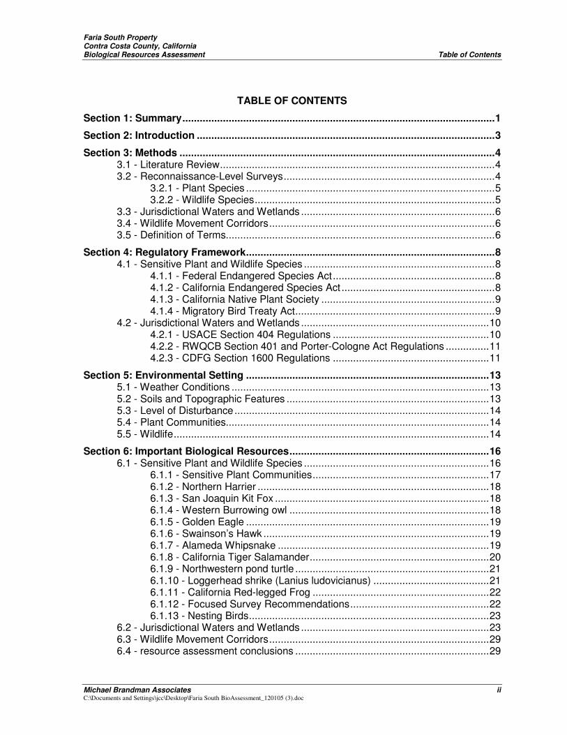
Faria South Property Contra Costa County, California Biological Resources Assessment Table of Contents
Michael Brandman Associates ii C:\Documents and Settings\jcc\Desktop\Faria South BioAssessment_120105 (3).doc
TABLE OF CONTENTS
Section 1: Summary............................................................................................................1
Section 2: Introduction .......................................................................................................3
Section 3: Methods .............................................................................................................4 3.1 - Literature Review...............................................................................................4 3.2 - Reconnaissance-Level Surveys.........................................................................4
3.2.1 - Plant Species ......................................................................................5 3.2.2 - Wildlife Species...................................................................................5
3.3 - Jurisdictional Waters and Wetlands ...................................................................6 3.4 - Wildlife Movement Corridors..............................................................................6 3.5 - Definition of Terms.............................................................................................6
Section 4: Regulatory Framework......................................................................................8 4.1 - Sensitive Plant and Wildlife Species ..................................................................8
4.1.1 - Federal Endangered Species Act........................................................8 4.1.2 - California Endangered Species Act .....................................................8 4.1.3 - California Native Plant Society ............................................................9 4.1.4 - Migratory Bird Treaty Act.....................................................................9
4.2 - Jurisdictional Waters and Wetlands .................................................................10 4.2.1 - USACE Section 404 Regulations ......................................................10 4.2.2 - RWQCB Section 401 and Porter-Cologne Act Regulations ...............11 4.2.3 - CDFG Section 1600 Regulations ......................................................11
Section 5: Environmental Setting ....................................................................................13 5.1 - Weather Conditions .........................................................................................13 5.2 - Soils and Topographic Features ......................................................................13 5.3 - Level of Disturbance........................................................................................14 5.4 - Plant Communities...........................................................................................14 5.5 - Wildlife.............................................................................................................14
Section 6: Important Biological Resources.....................................................................16 6.1 - Sensitive Plant and Wildlife Species ................................................................16
6.1.1 - Sensitive Plant Communities.............................................................17 6.1.2 - Northern Harrier ................................................................................18 6.1.3 - San Joaquin Kit Fox ..........................................................................18 6.1.4 - Western Burrowing owl .....................................................................18 6.1.5 - Golden Eagle ....................................................................................19 6.1.6 - Swainson’s Hawk ..............................................................................19 6.1.7 - Alameda Whipsnake .........................................................................19 6.1.8 - California Tiger Salamander..............................................................20 6.1.9 - Northwestern pond turtle ...................................................................21 6.1.10 - Loggerhead shrike (Lanius ludovicianus) ........................................21 6.1.11 - California Red-legged Frog .............................................................22 6.1.12 - Focused Survey Recommendations................................................22 6.1.13 - Nesting Birds...................................................................................23
6.2 - Jurisdictional Waters and Wetlands .................................................................23 6.3 - Wildlife Movement Corridors............................................................................29 6.4 - resource assessment conclusions ...................................................................29
Faria South Property Contra Costa County, California Biological Resources Assessment Table of Contents
Michael Brandman Associates iii C:\Documents and Settings\jcc\Desktop\Faria South BioAssessment_120105 (3).doc
Section 7: Biological Analysis of Faria South Property in Relation to the Proposed East Contra Costa County Habitat Conservation Plan and Natural Community Conservation Plan .................................................................33
7.1 - Introduction......................................................................................................33 7.1.1 - Location ............................................................................................33 7.1.2 - General Plan Land Use Designations................................................33 7.1.3 - Pittsburg Urban Limit Line .................................................................33
7.2 - Proposed HCP/NCCP Acquisition Areas .........................................................34 7.2.1 - Zone 1 Acquisition Areas ..................................................................34 7.2.2 - Preserve Acquisition Criteria .............................................................35 7.2.3 - Acquisition Requirements for Zone 1.................................................35
7.3 - summary of Biological features on the Faria South Property............................36 7.4 - Conclusions REgarding subZone 1a high priority acquisition designation........39
Section 8: References.......................................................................................................41
Section 9: Project Responsibility.....................................................................................44
Appendix A: Floral Compendium
List of Exhibits:
Exhibit 1: Regional Local Map
Exhibit 2: Local Vicinity Map
Exhibit 3: Local Vicinity USGS Map
Exhibit 4: Site Arial Map
Exhibit 5: CNDDB Map
Exhibit 6: Regional Watersheds
Exhibit 7: Site Sub-Watershed Map
Exhibit 8: HCP Fig. 5-2 - Acquisition Areas within Pittsburg Planning Area
LIST OF TABLES
Table 1: Special Status Plant Species.................................................................................24
Table 2: Special Status Wildlife Species..............................................................................27
Faria South Property Contra Costa County, California Biological Resources Assessment Summary
Michael Brandman Associates 1 C:\Documents and Settings\jcc\Desktop\Faria South BioAssessment_120105 (3).doc
SECTION 1: SUMMARY
Michael Brandman Associates (MBA) conducted a habitat assessment of Faria South property (approximately 370 acres) adjacent to the City of Pittsburg Urban Limit Line, Contra Costa County, California. The property, hereinafter referred to as the Project Site or Site, is designated for development under the City of Pittsburg General Plan, and lies within the City of Pittsburg Urban Limit Line. The majority of the Site is within an area proposed for high priority acquisition by the draft East Contra Costa County Habitat Conservation Plan and Natural Community Conservation Plan.
The Site is located on hilly terrain south and west of an area of expanding suburban development. It is dominated by a cover of grazed non-native grassland, consisting of common introduced grasses and forbs. Two small seasonal wetlands that were constructed for mitigation of filled wetlands at another property are located near the northwest border of the Site. Ephemeral unnamed drainage features heavily damaged by cattle ranching activities lay predominantly in the northern and eastern portions of the site.
The Project Site may provide suitable habitat for special status species of plants and animals. Special status species are native species that have been accorded special legal or management protection because of concern for their continued existence. There are several categories of protection at both federal and state levels, depending on the magnitude of threat to continued existence and existing knowledge of population levels. (See Section 4.0 and Section 5.0)
Fourteen sensitive plant species, known from grassland habitats in the vicinity of the Site, are not expected to occur. Focuses surveys during the blooming period of these plants will be conducted to better determine their presence or absence.
Portions of the Site contain known habitat for two sensitive wildlife species, the Northern Harrier and loggerhead shrike, which were observed during field surveys. Portions of the Site also contain potentially suitable habitat for five additional sensitive wildlife species: federally endangered San Joaquin kit fox, federally threatened California red-legged frog, federally threatened California tiger salamander (CTS), Golden eagles, and Western burrowing owl. The federally threatened California red-legged frog is known to utilize nearby ponds adjacent to the Project Site. Because they are known to travel over land, they may have potential to be found within grasslands on the site in
Faria South Property Contra Costa County, California Biological Resources Assessment Summary
Michael Brandman Associates 2 C:\Documents and Settings\jcc\Desktop\Faria South BioAssessment_120105 (3).doc
proximity to the ponds. The CTS is known to occur on Concord NWS to the west and to the north of the Site. In addition, they could possibly breed within the small man-made mitigation features located on northern perimeter of the Site. The CTS spend most of the year within underground refuges, especially those excavated by gophers and ground squirrels, both of which are present on the Project Site. Golden eagles were observed two miles southeast of the Project Site in similar grazed annual grasslands. This species is known to nest at the Concord Naval Weapons Station (NWS) on land immediately adjacent to the west and would be likely to forage for prey within the Project Site. However, there is not suitable nesting habitat on the Site. The Western burrowing owl has been documented in habitats similar to those on the Project Site on lands immediately adjacent to the west and to the southeast, although none were observed during the site surveys. The San Joaquin kit fox is known from historic records to have occurred on lands 5 miles east of the Project Site. There are no known occurrences of the kit fox in recent times within the site or in the general vicinity of the Site, and therefore there is a very low expectation that the species is currently present, in addition to the fact the there is a relatively large population of known predators (Golden Eagle and Coyotes).
The Project Site contains ephemeral drainages with relatively small tributary areas that flow into several different surface waters. One ephemeral drainage with a relatively small tributary area drains to the west into the Clayton Canal, and eventually into Mt. Diablo Creek within Concord NWS. The other ephemeral unnamed drainages flow to the north, including one unnamed drainage that flows to the north through existing development, and another unnamed drainage that flows to the north to several other unnamed drainages, and eventually into Willow Creek north east of the Site.
Two small ponds (approximately 2.3 acres), constructed as mitigation for wetlands losses at the Oak Hill development, contain seasonal wetlands. One pond is located on the San Marco Meadows property upstream of the other pond which is located on the Project Site. They are both located in the proposed ECCC HCP Subzone 1a High Acquisition Priority (HAP). These ponds and potentially lower reaches of the drainage feature may fall under the jurisdiction of the United States Army Corps of Engineers (USACE), Regional Water Quality Control Board (RWQCB), and California Department of Fish and Game (CDFG).
The Project Site lies between undeveloped lands to the west (comprising Concord NWS) and to the southeast that may allow movements of relatively mobile species across the Site from east to west. However, the lands north, northeast and southeast of the Site are developed or under development.
Faria South Property Contra Costa County, California Biological Resources Assessment Introduction
Michael Brandman Associates 3 C:\Documents and Settings\jcc\Desktop\Faria South BioAssessment_120105 (3).doc
SECTION 2: INTRODUCTION
The information contained herein is intended to provide baseline information about the existing and potential biological resources on the Site. Further analysis in this report focuses on determining the biological sensitivity of the majority of the Site within the proposed East Contra Costa County Draft Habitat Conservation Plan and Natural Community Conservation Plan (HCP/NCCP) area.
The Project Site is in unincorporated Contra Costa County, adjacent to the City of Pittsburg. The Site is designated for residential development under the City of Pittsburg General Plan, and lies within the City of Pittsburg Urban Limit Line and is zoned for residential development. See Exhibit 8. The property is shaped in a series of northwest-to-southeast trending triangles, with the bulk of the land area concentrated in the southeastern portion of the property. The Site is bounded by Concord NWS (west and south), the San Marco Meadows property and the existing San Marco development in the City of Pittsburg (north), and the proposed Bailey Estates property (south). The Site consists of topographic terrain ranging in elevation from approximately 450 to 850 feet above mean sea level.
Faria South Property Contra Costa County, California Biological Resources Assessment Methods
Michael Brandman Associates 4 C:\Documents and Settings\jcc\Desktop\Faria South BioAssessment_120105 (3).doc
SECTION 3: METHODS
Analysis of the biological resources associated with the Project Site began with a review of relevant literature followed by a reconnaissance-level field surveys. The primary objective of the surveys were to document existing site conditions with emphasis on the potential presence of special status species or their habitat, and to determine the relationship of resources on the Site to HCP/NCCP conservation strategy goals. During the survey, MBA’s biologist also evaluated the site for potentially jurisdictional drainage features, but a formal jurisdictional delineation was not conducted
3.1 - LITERATURE REVIEW
The literature review provides a baseline from which to evaluate the biological resources potentially occurring on the Project Site, as well as the surrounding area. A compilation of sensitive plant and wildlife species recorded within 10-mile radius of the Site was derived from the CDFG’s California Natural Diversity Database (CNDDB), a sensitive species and plant community account database. Additional recorded occurrences of plant species found on or near the Site were obtained in the California Native Plant Society’s (CNPS) Electronic Inventory of Rare and Endangered Vascular Plants of California database. The CNDDB and CNPS search was based on the Vine Hill, Honker Bay, Antioch North, Walnut Creek, Clayton and Antioch South USGS 7.5-minute topographic quadrangles.
Federal register listings, protocols, and species data provided by the U.S. Fish and Wildlife Service (USFWS) and CDFG were reviewed in conjunction with anticipated federal and state listed species potentially occurring within the 10-mile radius of the Site. The HCP/NCCP was reviewed and analyzed. These and other references are listed in Section 8, References.
3.2 - RECONNAISSANCE-LEVEL SURVEYS
Dr. Michael Brandman conducted a preliminary survey of the Project Site on October 27, 2005. MBA biologist Michael Marangio conducted a reconnaissance-level survey of the Site on foot on November 1, 2 and 3, 2005. Special attention was paid to sensitive habitats or those areas potentially supporting sensitive flora and fauna species. The reconnaissance-level survey focused on special status species assessment.
Plant communities within the Project Site were classified at a general level of detail using the widely accepted descriptions provided in Holland’s Preliminary Descriptions of the Terrestrial Natural
Faria South Property Contra Costa County, California Biological Resources Assessment Methods
Michael Brandman Associates 5 C:\Documents and Settings\jcc\Desktop\Faria South BioAssessment_120105 (3).doc
Communities of California (1986 and 1992 update). Survey results for plant and wildlife species are described in Section 4.
The survey was conducted in late autumn. Overall wildlife species’ activity can be considered moderate as resident wildlife species were likely to be present although migratory avian species had begun to depart on their fall migrations.
Many amphibians, reptiles, and mammals are secretive by nature and some are only nocturnally active, making diurnal observations problematic. Observations of diagnostic signs may provide evidence of occurrence of these species. Otherwise, conclusions regarding potential occurrence are based on consideration of habitat suitability factors.
3.2.1 - Plant Species
Common plant species observed during the field surveys were identified by visual characteristics and morphology in the field and recorded in a field notebook. Uncommon and less familiar plants were identified offsite using taxonomical guides. A list of all species observed on the Project Site was compiled from the survey data, shown in Appendix A. Taxonomic nomenclature used in this study follows Hickman (1993). In this report, scientific names are provided immediately following common names of plant species (first reference only).
3.2.2 - Wildlife Species
Wildlife species detected during the field survey by sight, calls, tracks, scat, or other signs were recorded in a field notebook. Notations were made regarding general habitats for sensitive species potentially occurring on the Project Site based on our preliminary assessment of the cited literature. Field guides were used to assist with identification of species during surveys and included Stebbins (2003) for amphibians and reptiles, National Geographic Society (1987) for birds, and Burt and Grossenheider (1980) for mammals. Common names of wildlife species are standard; however, scientific names are provided immediately following common names (first reference only). Appendix A lists all vertebrate wildlife species observed or detected on the Project Site during the survey.
The general wildlife survey was conducted on foot during daylight hours. The object of this survey was to ascertain general biological conditions and identify habitat areas that could be suitable for various sensitive plant and wildlife species. Sensitive species are generally considered potentially present on the Project Site if suitable habitat is present, the area lies within a species’ geographic range, and the species has been recorded to occur within the reasonable vicinity of the Project Site.
Faria South Property Contra Costa County, California Biological Resources Assessment Methods
Michael Brandman Associates 6 C:\Documents and Settings\jcc\Desktop\Faria South BioAssessment_120105 (3).doc
MBA’s biologist inspected habitats for diagnostic wildlife signs such as nests, burrows, tracks, vocalizations, and noted all direct observations. The biologist also inspected stones and boards to look for secretive reptiles and amphibians.
Surveys for raptors (birds of prey) were conducted simultaneously with the field surveys. Efforts included direct and incidental observation of raptor foraging areas, nests, owl pellets, and the identification of soaring or perched raptor species.
3.3 - JURISDICTIONAL WATERS AND WETLANDS
Prior to conducting the reconnaissance-level survey, MBA’s biologist reviewed USGS topographic maps and aerial photography to identify any potential natural drainage features and water bodies that may fall within the jurisdiction of the USACE, RWQCB, and/or CDFG. In general, all surface drainage features indicated as blue-line streams on USGS maps and linear patches of vegetation expected to exhibit evidence of flows are considered potentially subject to state and federal regulatory authority as “waters of the U.S. and/or State.” Further discussion of jurisdictional areas can be found in Section 4.2.
The Project Site was preliminarily evaluated for jurisdictional drainage features and wetland areas during the reconnaissance-level survey. The survey assessed the Site’s current existing conditions; however, a formal jurisdictional delineation was not conducted.
3.4 - WILDLIFE MOVEMENT CORRIDORS
Information compiled from the literature review, including the NCCP/HCP, and direct observations made during the field survey provided the basis for an assessment of the Project Site as a wildlife movement corridor.
3.5 - DEFINITION OF TERMS
Blue-Line Drainage: A drainage feature indicated by a blue line on USGS 7.5-minute topographic maps.
Drainage Feature: A topographic low area that channels run-off from storm events. Drainage features are often considered streams, rivers, creeks, and brooks, but may also include upland drainages that are dry during most of the year. Drainage features typically have a definable bed and bank feature caused by erosion from moving water.
Faria South Property Contra Costa County, California Biological Resources Assessment Methods
Michael Brandman Associates 7 C:\Documents and Settings\jcc\Desktop\Faria South BioAssessment_120105 (3).doc
Focused Survey: A survey for a specific species that has been designated by the CDFG or USFWS as sensitive and has a written protocol approved by the USFWS.
Plant Communities: A classification of a natural or human influenced assemblage of plants that have common characteristics and can be easily identified by key plant species.
Reconnaissance-Level Survey: A field investigation of common plant and wildlife species observed within a project site that is often limited to a single point in time during the year. The survey is conducted to obtain a general understanding of the habitats within the property and not to systematically survey the entire property for every plant and wildlife species present.
Taxonomic Nomenclature: A system of labeling an individual species with a Latin-based scientific name.
Faria South Property Contra Costa County, California Biological Resources Assessment Regulatory Framework
Michael Brandman Associates 8 C:\Documents and Settings\jcc\Desktop\Faria South BioAssessment_120105 (3).doc
SECTION 4: REGULATORY FRAMEWORK
4.1 - SENSITIVE PLANT AND WILDLIFE SPECIES
Sensitive species are native species that have been accorded special legal or management protection because of concern for their continued existence. There are several categories of protection at both federal and state levels, depending on the magnitude of threat to continued existence and existing knowledge of population levels.
4.1.1 - Federal Endangered Species Act
The U.S. Fish and Wildlife Service (USFWS) administers the Federal Endangered Species Act (FESA). The FESA provides a process for listing species as either threatened or endangered, and methods of protecting listed species. The FESA defines as “endangered” any plant or animal species that is in danger of extinction throughout all or a significant portion of its range. A “threatened” species is a species that is likely to become endangered in the foreseeable future. A “proposed” species is one that has been officially proposed by the USFWS for addition to the federal threatened and endangered species list.
Section 9 of the FESA prohibits “take” of threatened or endangered species. The term “take” means to harass, harm, pursue, hunt, shoot, wound, kill, trap, capture, or collect, or to attempt to engage in such conduct. Take can include disturbance to habitats used by a threatened or endangered species during any portion of its life history. The presence of any federally threatened or endangered species that is in a project area generally imposes severe constraints on development, particularly if development would result in “take” of the species or its habitat. Under the regulations of the FESA, the USFWS may authorize “take” when it is incidental to, but not the purpose of, an otherwise lawful act. The purpose of the HCP/NCCP is to set forth preservation, conservation and mitigation measures that will provide the basis for issuance of take authorization for a number of “Covered Species,” that are or may become listed as threatened or endangered under the FESA.
4.1.2 - California Endangered Species Act
The California Department of Fish and Game administers the California Endangered Species Act (CESA). The State of California considers an “endangered” species one whose prospects of survival and reproduction are in immediate jeopardy. A “threatened” species is one present in such small numbers throughout its range that it is likely to become an endangered species in the near future in the absence of special protection or management. A “candidate” species is one which is proposed for
Faria South Property Contra Costa County, California Biological Resources Assessment Regulatory Framework
Michael Brandman Associates 9 C:\Documents and Settings\jcc\Desktop\Faria South BioAssessment_120105 (3).doc
listing. A “rare” species is one present in such small numbers throughout its range that it may become endangered if its present environment worsens. The rare species is a more informal designation applies to California native plants. State threatened and endangered species are also protected against “take” under the California Endangered Species Act, which is defined ad. Similar to FESA, CESA contains provisions permitting the incidental take of species in conjunction with development. The purpose of the HCP/NCCP is to set forth preservation, conservation and mitigation measures that will provide the basis for issuance of take authorization for a number of “Covered Species,” that are or may become listed as threatened or endangered under the FESA. The term “species of special concern” is an informal designation used by CDFG for some declining wildlife species that are not state candidates for listing. This designation does not provide legal protection, but signifies that these species are recognized as sensitive by CDFG.
4.1.3 - California Native Plant Society
The California Native Plant Society (CNPS) is a California resource conservation organization that has developed an inventory of California’s sensitive plant species (Tibor 2001). This inventory summarizes information on the distribution, rarity, and endangerment of California’s vascular plants. The inventory is divided into four lists based on the rarity of the species. In addition, the CNPS provides an inventory of plant communities that are considered sensitive by the state and federal resource agencies, academic institutions, and various conservation groups. Determination of the level of sensitivity is based on the number and size of remaining occurrences as well as recognized threats.
4.1.4 - Migratory Bird Treaty Act
The Migratory Bird Treaty Act (MBTA) protects all common wild birds found in the United States except the house sparrow, starling, feral pigeon, and resident game birds such as pheasant, grouse, quail, and wild turkey. Resident game birds are managed separately by each state. The MBTA makes it unlawful for anyone to kill, capture, collect, possess, buy, sell, trade, ship, import, or export any migratory bird including feathers, parts, nests, or eggs.
CDFG code 3503 makes it illegal to destroy any birds’ nest or any birds’ eggs that are protected under the MBTA. Code 3503.5 further protects all birds in the orders Falconiformes and Strigiformes (birds of prey, such as hawks and owls) and their eggs and nests from any form of take.
Faria South Property Contra Costa County, California Biological Resources Assessment Regulatory Framework
Michael Brandman Associates 10 C:\Documents and Settings\jcc\Desktop\Faria South BioAssessment_120105 (3).doc
4.2 - JURISDICTIONAL WATERS AND WETLANDS
Impacts to natural drainage features and wetland areas are regulated by the U.S. Army Corps of Engineers (USACE), the Regional Water Quality Control Board (RWQCB), and CDFG based upon the policies discussed below.
4.2.1 - USACE Section 404 Regulations
The discharge of dredged or fill material (temporarily or permanently) into areas delineated as waters of the United States, including wetlands, typically requires prior authorization from the USACE, pursuant to Section 404 of the Clean Water Act.
Waters of the United States
Waters of the United States, as defined in the Code of Federal Regulations (CFR) 328.3, include all waters or tributaries to waters such as lakes, rivers, ephemeral, intermittent and perennial streams, mudflats, sand-flats, natural ponds, wetlands, wet meadows, and other aquatic habitats. Frequently, waters of the United States (with at least intermittently flowing water or tidal influences) are demarcated by an ordinary high water mark (OHWM). The OHWM is defined in CFR 328.3(e) as the line on the shore established by the fluctuations of water and indicated by physical characteristics such as a clear, natural line impressed on the bank shelving, changes in the character of soil, destruction of terrestrial vegetation, the presence of litter and debris, or other appropriate means that consider the characteristics of the surrounding areas. In this region, the OHWM is typically indicated by the presence of an incised streambed with defined bank shelving.
Wetlands
Wetlands are one type of jurisdictional Water of the United States. According to the Federal Manual for Identifying and Delineating Jurisdictional Wetlands (1987), three criteria must be satisfied to classify an area as a jurisdictional wetland: (1) a predominance of plant life that is adapted to life in wet conditions (hydrophytic vegetation); (2) soils that saturate, flood, or pond long enough during the growing season to develop anaerobic conditions in the upper part (hydric soils); and (3) permanent or periodic inundation or soils saturation, at least seasonally (wetland hydrology). Wetland vegetation is characterized by vegetation in which more than 50 percent of the composition of dominant plant species are obligate wetland, facultative wetland, and/or facultative species that occur in wetlands. As a result of the 2001 Solid Waste Agency of North Cook County (SWANCC) case, a wetland must show connectivity to a jurisdictional Water of the United States in order for such a feature to be considered jurisdictional. Although wetland criteria was used to identify if areas were considered
Faria South Property Contra Costa County, California Biological Resources Assessment Regulatory Framework
Michael Brandman Associates 11 C:\Documents and Settings\jcc\Desktop\Faria South BioAssessment_120105 (3).doc
wetlands, the exact limits of jurisdiction were not measured based on the standard wetland delineation protocol as described in the 1987 USACE manual.
USACE Regulated Activities
The USACE regulates the discharge of dredged or fill material including, but not limited to, grading, placing of rip-rap for erosion control, pouring concrete, laying sod, and stockpiling excavated material. Activities that generally do not involve a regulated discharge (if performed specifically in a manner to avoid discharges) include driving pilings, drainage channel maintenance, maintenance of farm/forest roads, and excavating without incidental fill or stockpiling.
4.2.2 - RWQCB Section 401 and Porter-Cologne Act Regulations
Section 401 of the Clean Water Act
Section 401 of the Clean Water Act (CWA) requires that “any applicant for a Federal permit for activities that involve a discharge to waters of the State, shall provide the Federal permitting agency a certification from the State in which the discharge is proposed that states that the discharge will comply with the applicable water quality provisions under the Federal Clean Water Act.” Therefore, before the USACE will issue a Section 404 permit, applicants must apply for and receive a Section 401 water quality certification from the RWQCB.
Porter-Cologne Act
The RWQCB regulates actions that would involve “discharging waste, or proposing to discharge waste, within any region that could affect the water of the state” (water code 13260(a)), pursuant to provisions of the State Porter-Cologne Water Quality Act. “Waters of the State” are defined as “any surface water or groundwater, including saline waters, within the boundaries of the state” (water code 13050 (e)).
RWQCB Regulated Activities
Under Section 401 of the CWA, the RWQCB regulates all activities that are regulated by the USACE. Additionally, under the Porter-Cologne Act, the RWQCB has jurisdiction over all activities involving discharge of waste into waters of the state that are not regulated by the USACE due to a lack of connectivity with a navigable water body and/or lack of an OHWM.
4.2.3 - CDFG Section 1600 Regulations
The Fish and Game Code of California mandates that “it is unlawful for any person to substantially divert or obstruct the natural flow or substantially change the bed, channel, or bank of any river,
Faria South Property Contra Costa County, California Biological Resources Assessment Regulatory Framework
Michael Brandman Associates 12 C:\Documents and Settings\jcc\Desktop\Faria South BioAssessment_120105 (3).doc
stream, or lake designated by the department, or use any material from the streambeds, without first notifying the department of such activity.” CDFG jurisdiction includes ephemeral, intermittent and perennial watercourses (including dry washes) characterized by (1) the presence of hydrophytic vegetation; (2) the location of definable bed and banks; and (3) the presence of existing fish or wildlife resources.
Furthermore, CDFG jurisdiction is often extended to habitats adjacent to watercourses, such as oak woodlands in canyon bottoms or willow woodlands that function as part of the riparian system. Historic court cases have further extended CDFG jurisdiction to include watercourses that seemingly disappear, but re-emerge elsewhere. Under the CDFG definition, a watercourse need not exhibit evidence of an OHWM to be claimed as jurisdiction. However, CDFG does not regulate isolated wetlands; that is, those that are not associated with a river, stream, or lake.
CDFG Regulated Activities
The CDFG regulates activities that involve diversions, obstruction, or changes to the natural flow or bed, channel, or bank of any river, stream, or lake that supports fish or wildlife resources.
Faria South Property Contra Costa County, California Biological Resources Assessment Environmental Setting
Michael Brandman Associates 13 C:\Documents and Settings\jcc\Desktop\Faria South BioAssessment_120105 (3).doc
SECTION 5: ENVIRONMENTAL SETTING
5.1 - WEATHER CONDITIONS
During the field surveys, weather conditions included average temperatures of 68° to 73° Fahrenheit and a range of clear and cloudy skies. Light winds to strong gusty winds were encountered over the 3 days of field surveys, especially near hilltops.
5.2 - SOILS AND TOPOGRAPHIC FEATURES
The Project Site contains several soil series. A soil series is a group of soils with similar profiles. These profiles include major horizons with similar thickness, arrangement, and other important characteristics. Most of the soils are Diablo Series on the steeper hills and Capay Series on the lowlands or less steep slopes. (United States Department of Agriculture (USDA) Soil Survey, Contra Costa County 1975).
The Project Site is generally located within an area of topographic terrain. Elevations on the Site range from about 450 to 850 feet above mean sea level.
A small portion of the Project Site is tributary to unnamed drainages that flow to the main channel of Willow Creek. The area of the Site tributary to Willow Creek totals approximately 99 acres (or 0.9%) within the approximately 11,370 acres of the Willow Creek subbasin.
Willow Creek subbasin, as described in the draft ECCC HCP (JSA, 2005). This subbasin contains many small drainage features, the largest of which is Willow Creek’s, located just south and east of the Site. All drainages in this subbasin are ephemeral and have been substantially modified by years of heavy grazing by cattle, due to a typically long dry season. Most of this subbasin is characterized by urban development, with the majority of downstream reaches of the drainages redirected through underground culverts. Most of the unnamed drainages within this subbasin west of Willow Creek have been altered by existing developments. See Exhibits 6 and 7. Willow Creek eventually flows north into Suisin Bay at the northern edge of Contra Costa County.
A very small portion of the northwestern edge of the Project Site, which also contains the two man-made mitigation features, drains to the west toward Concord NWS and into the Clayton Canal. This
Faria South Property Contra Costa County, California Biological Resources Assessment Environmental Setting
Michael Brandman Associates 14 C:\Documents and Settings\jcc\Desktop\Faria South BioAssessment_120105 (3).doc
66-acre (or 0.8%)portion of the Site including approximately 32 acres of the San Marco Meadows property is a part of the 8,235-acre upper Mt. Diablo Creek subbasin.
The northern and eastern portions of the site drain toward the north as unnamed tributaries. These unnamed drainages flow north into Suisin Bay at the northern edge of Contra Costa County.
5.3 - LEVEL OF DISTURBANCE
The Project Site is heavily disturbed as a result of many years of cattle grazing and ranching. The properties are fenced into smaller areas. Grazing animals are moved from area to area throughout the year. Drainages are typically used as cattle paths with ground cover of non-native grasses undifferentiated from surrounding slopes.
5.4 - PLANT COMMUNITIES
Most of the area consists of grazed California Annual (non-native) Grassland Series (Sawyer and Keeler-Wolf, 1995). Dominant species include wild-oat (Avena fatua), Italian ryegrass (Lolium multiflorum), yellow star-thistle (Centaurea solsitialis), with scattered yarrow (Achillea millefolium), bull thistle (Cirsium vulgare), bristly ox-tongue (Picris echiodes), milk thistle (Silybum marianum), and curly dock (Rumex crispus).
A small area set aside as a man-made wetland mitigation is located near the northwest edge of the Project Site. The sites were constructed by development of berms and excavations to help trap water within a small drainage. The ponded areas would be considered seasonal wetland. Water was not present during the November 1-3, 2005 field surveys. Plantings of willow (Salix sp.), Fremont cottonwood (Populus fremontii), and patches of cattail (Typha sp.), smartweed (Polygonum sp.), and bullrush (Scirpus acutus) were identified at these wetland sites.
5.5 - WILDLIFE
The Project Site provides habitat for common wildlife species that occur in annual grasslands. Common wildlife species (non-sensitive species) observed on or in the vicinity of the Site include coyote (Canis latrans), black-tailed hare (Lepus californicus), California ground squirrel (Spermophilus beecheyi), California vole (Microtus californicus), Botta’s pocket gopher (Thomomys bottae), red tailed hawk (Buteo jamaicensis), American kestrel (Falco sparverius), Northern harrier (Circus cyaneus) western meadowlark (Sturnella neglecta), Brewer’s blackbird (Euphagus cyanocephalus), European starling (Sturnus vulgaris), savannah sparrow (Passerculus sandwichensi),
Faria South Property Contra Costa County, California Biological Resources Assessment Environmental Setting
Michael Brandman Associates 15 C:\Documents and Settings\jcc\Desktop\Faria South BioAssessment_120105 (3).doc
mourning dove (Zenaida macroura), rock dove (Columbia livia), western kingbird (Tyrannus verticalis), loggerhead shrike (Lanius ludovicianus), and western fence lizard (Sceloporus occidentalis).(
Faria South Property Contra Costa County, California Biological Resources Assessment Important Biological Resources
Michael Brandman Associates 16 C:\Documents and Settings\jcc\Desktop\Faria South BioAssessment_120105 (3).doc
SECTION 6: IMPORTANT BIOLOGICAL RESOURCES
6.1 - SENSITIVE PLANT AND WILDLIFE SPECIES
On the basis of a review of several references, including the HCP/NCCP, and CNDDB and CNPS sensitive species lists for Vine Hill, Honker Bay, Antioch North, Walnut Creek, Clayton and Antioch South USGS 7.5-minute topographic quadrangles, MBA determined that within a 10 miles radius of the site 47 sensitive plant species and 32 sensitive wildlife species have been recorded to occur within the six USGS quad sheet maps that cover the vicinity of the Project Site. A listing of all known potential sensitive plant and wildlife is presented in Table 1 and Table 2. These tables identify each sensitive plant and wildlife species, their federal and state status, required habitat, and potential to occur within the Project Site.
A sensitive species is considered a potential inhabitant if its known geographical distribution encompasses part of the Site, or if its recorded occurrence was in the vicinity and its general habitat requirements are present.
A sensitive plant or wildlife species’ could potentially occur on the Project Site is based upon the following criteria:
Not Likely to Occur - There are no present or historical records of the species occurring on or in the immediate vicinity (within 3 miles) of the Project Site and the diagnostic habitats strongly associated with species do not occur on or in the immediate vicinity of the Site.
Low Potential to Occur - There is a historical record of the species in the vicinity of the Project Site and potentially suitable habitat on Site, but existing conditions (e.g., density of cover, prevalence of non-native species, evidence of disturbance, limited habitat area, isolation) substantially reduce the possibility that the species may occur. The Site is above or below the recognized elevation limits for this species.
Moderate Potential to Occur - The diagnostic habitats associated with the species occur on or in the immediate vicinity of the Project Site, but there is not a recorded occurrence of the species within the immediate vicinity (within three miles). Some species that contain extremely limited distributions may be considered moderate, even if there is a recorded occurrence within the vicinity.
Faria South Property Contra Costa County, California Biological Resources Assessment Important Biological Resources
Michael Brandman Associates 17 C:\Documents and Settings\jcc\Desktop\Faria South BioAssessment_120105 (3).doc
High Potential to Occur - There is both a historical record of the species in the immediate vicinity of the Project Site and the diagnostic habitats strongly associated with the species occur on or in the immediate vicinity.
Species Present - The species was observed on the Project Site at the time of the field survey or during a survey in the recent past. 6.1.1 - Sensitive Plant Communities
Based on MBA’s literature and Site review, the only sensitive plant community known to occur on the Project Site is seasonal wetlands constructed as part of a mitigation plan for loss of jurisdictional wetlands. These areas are fenced and posted as protected sites and are managed for maintenance of wetland vegetation and habitat (James Coniglio, Discovery Homes, personal communication 2005).
Sensitive Plant Species
Within a 10-mile radius of the site, MBA determined that forty-seven sensitive plant species are known to occur. Of these 47 species within the general area of the Project Site, 34 were eliminated on the basis of lack of suitable habitat. Fourteen were chosen for further evaluation regarding their potential presence. All 14 were determined to have a low potential to be present because the area is heavily grazed. A list of sensitive native plant species recognized as potentially present by the CNDDB, CNPS, and MBA is presented in Table 1.
Sensitive Wildlife Species
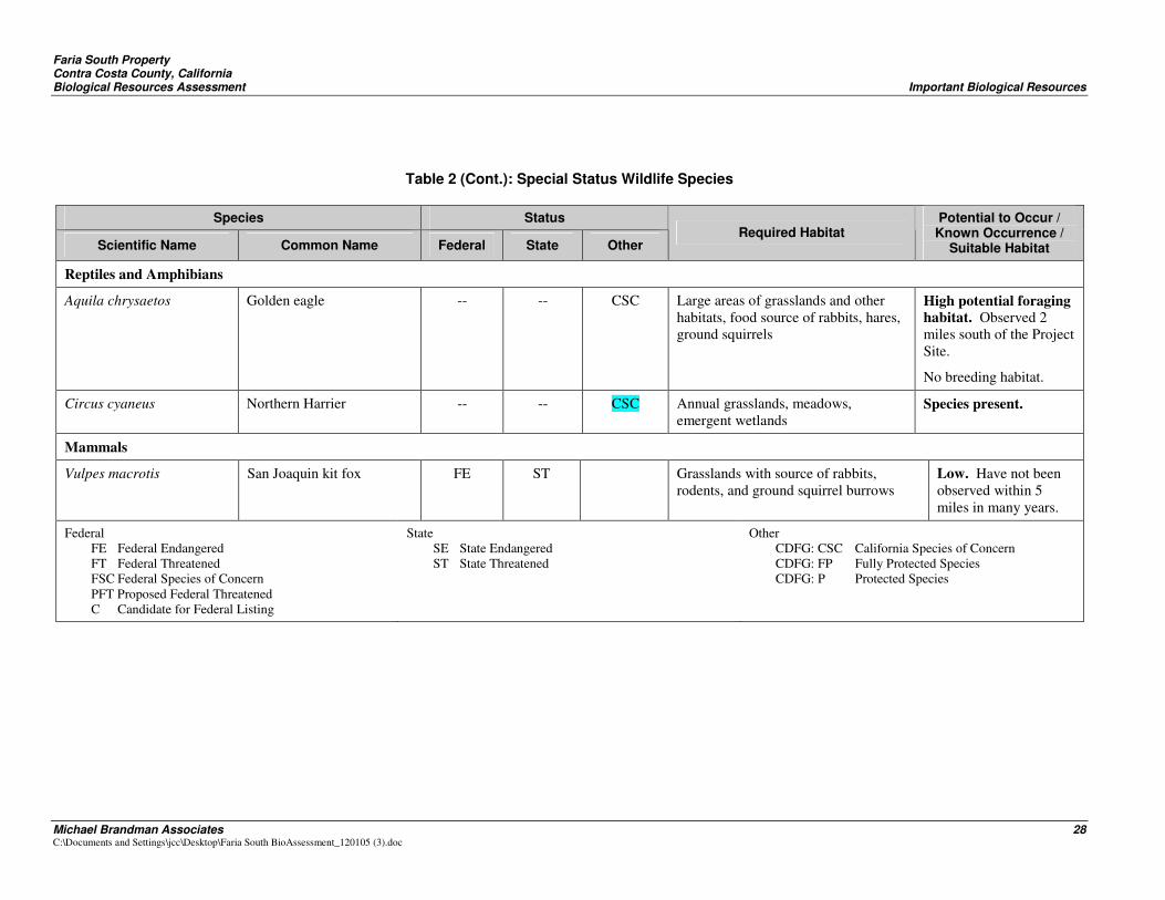
Of the thirty-five sensitive wildlife species known to be present within a 10-mile radius of the Project Site, 9 were chosen for further evaluation after eliminating those that have habitat requirements not available on the Project Site. Of these, two sensitive wildlife species, loggerhead shrike (Lanius ludovicianus) and Northern harrier (Circus cyaneus) were observed on the Project Site. A discussion of each sensitive wildlife species recognized from the literature and MBA’s assessment as potentially present on the Site is presented in Table 2.
A number of sensitive wildlife species are known to occur within a 10-mile radius around the Project Site, and MBA considers it important to evaluate the potential for occurrence of species on the site based on Site conditions. These include San Joaquin Kit Fox, Western Burrowing Owl, Golden Eagle, Swainson’s Hawk, Alameda Whipsnake, California Tiger salamander, and California red-legged frog. Further discussion of these species follows in order to evaluate their potential for presence on the property.
Faria South Property Contra Costa County, California Biological Resources Assessment Important Biological Resources
Michael Brandman Associates 18 C:\Documents and Settings\jcc\Desktop\Faria South BioAssessment_120105 (3).doc
6.1.2 - Northern Harrier
(Circus cyaneus) is a State Species of Concern. It is a bird of prey that feeds mainly upon voles and other small mammals, birds, frogs, and crustaceans. It nests on the ground in shrubby vegetation, usually at a marsh edge. It breeds from April to September, with peak nesting activity June through July. Several were observed foraging within the Project Site during field visits to the site.
6.1.3 - San Joaquin Kit Fox
This species is designated as federally endangered and state threatened. Kit fox are usually associated with a cover of annual grassland that is present over most of the Project Site. Kit fox prey species such as California ground squirrel and Botta’s gopher were also present. A recent survey of Contra Costa County and Alameda Counties within the known range of the San Joaquin kit fox found no evidence of recent occupancy. These results suggest that kit fox density is low or their population fluctuates in the inventory area (Clark et al. 2003).
The closest known sighting is at Black Diamond Mines Regional Park, which is approximately five miles east of the project site. Kit fox have at most a very low potential to occur on the site. CDFG concluded in that the Vista Del Mar Project immediately adjacent and east of the property “is outside of CDFG’s recognized kit fox range”. (Cited in City of Pittsburg 2004). San Joaquin Kit Fox is unlikely to be present on the site in addition to the fact that there is a relatively large population of known predators (Golden Eagles and Coyotes).
6.1.4 - Western Burrowing owl
The Western Burrowing Owl is a California species of concern that is protected by the Migratory Bird Treaty Act (MBTA) and CDFG Code. It is distributed over most of California. Burrowing owls require habitat with open, well-drained terrain, short, sparse vegetation, and underground burrows (Klute et al. 2003). Burrowing owls are found in grasslands, deserts, sagebrush scrub, agricultural areas (including pastures and untilled margins of cropland), earthen levees, coastal uplands, and urban vacant lots, as well as the margins of airports, golf courses, and roads.
The most important habitat consideration for the western burrowing owl is the availability of underground burrows, especially California ground squirrel holes. Food sources consist of arthropods, small mammals, birds, amphibians, and reptiles.
The Project Site consists of grassland and contains many areas with California ground squirrels. Burrowing owls have been observed on property immediately adjacent to the southeast portion of the Project Site (CNDDB 2005), and are known from Concord NWS property immediately west of the
Faria South Property Contra Costa County, California Biological Resources Assessment Important Biological Resources
Michael Brandman Associates 19 C:\Documents and Settings\jcc\Desktop\Faria South BioAssessment_120105 (3).doc
Project Site (Tetra Tech 2002). Although no burrowing owls were observed during field surveys, habitat conditions are suitable for this species and therefore they have a moderate potential for being present, although none were observed during the surveys.
6.1.5 - Golden Eagle
Golden eagles forage within many types of terrestrial habitats. Within the Project Site, golden eagles favor open grasslands. Secluded cliffs with overhanging ledges and large trees are used for nesting and cover but do not occur on the Project Site. Territory size averages 124 square kilometers (sq km) in northern California, but can vary with habitat conditions. Therefore, the Project Site represents a very small portion of their territory. Golden eagles prey mostly on rabbits, California ground squirrels, black-tailed hares, and rodents, but also take other mammals, birds, and reptiles. California ground squirrels and black-tailed jackrabbits are the 2 most important prey species for the golden eagle, which are present on the Site. They are likely to forage for prey on the Project Site, but no suitable nesting habitat is present.
Golden eagles nest periodically at Concord NWS, along the ridge tops (Tetra Tech 2002). They were observed on grazed annual grassland about 2 miles southeast on November 16, 2005 by MBA biologist.
6.1.6 - Swainson’s Hawk
Historically, the Swainson’s hawk probably foraged in upland and seasonally flooded perennial grasslands of California. Currently, Swainson’s hawks forage in low-growing crops and are more abundant in areas of moderate cultivation than in either grassland areas or areas of intensive cultivation. This species preys on small mammals, birds, toads, crayfish, and insects. Swainson’s hawks are strongly associated with riparian forests. Presence of suitable nest trees combined with proximity to high-quality foraging habitat is necessary for reproduction.
No riparian forest or low-growing crops are present on the surveyed site. For this reason, Swainson’s hawk would not be expected to be present there.
6.1.7 - Alameda Whipsnake
The federally threatened Alameda whipsnake occurs primarily in coastal scrub and chaparral communities, but also is found in a variety of other communities in the inner Coast Range, including grasslands and open woodlands (Swaim 1994). Rock outcrops with deep crevices or abundant rodent burrows are important habitat components for overnight dens, refuges from predators, and foraging
Faria South Property Contra Costa County, California Biological Resources Assessment Important Biological Resources
Michael Brandman Associates 20 C:\Documents and Settings\jcc\Desktop\Faria South BioAssessment_120105 (3).doc
(Swaim 1994). According to USFWS (2000), suitable habitat includes communities of mixed chaparral, coastal scrub, and annual grassland and oak woodlands that are adjacent to scrub habitats.
Grassland areas that are linked to scrub by rock outcrops or river corridors are also considered essential habitat elements (U.S. Fish and Wildlife Service 2000). Alameda whipsnake especially prefers lizard prey, especially the western fence lizard.
The Project Site contains insignificant rock outcrops. No chaparral or coastal scrub plant communities are present. Although the main food item of the Alameda Whipsnake, the western fence lizard, is present, the snake is unlikely to utilize the site because of the lack of chaparral and coastal scrub plant communities on or adjacent to the site.
6.1.8 - California Tiger Salamander
The federally threatened California tiger salamander occurs within the Central Valley and Sierra Nevada Foothills, from Yolo County south to Tulare County, and in the coastal valleys and foothills from Sonoma County south to Santa Barbara County. It is listed as federally threatened, and is protected under the Endangered Species Act.
This species requires two important habitat components: (1) aquatic breeding sites and (2) terrestrial estivation or refuge sites. California tiger salamanders typically inhabit valley and foothill grasslands and the grassy understory of open woodlands, usually within 1 mile of water (Jennings and Hayes 1994). This amphibian is terrestrial as an adult, spending most of its time underground in subterranean retreats usually consisting of ground-squirrel burrows and Botta pocket gopher holes. During the winter adults emerge from underground to migrate to ponds to breed.
CTS populations are known to use four primary breeding ponds in Concord NWS to the west of the Project Site: two cattle ponds in the upper hills adjacent to the Project Site and two ponds in the lower area. (Tetra Tech 2002). Adult salamanders may be utilizing upland terrestrial habitat area on the Faria South property since it lies within 1 mile of two of the Concord NWS ponds.
California tiger salamanders were observed from the southern end and in the central portion of the Vista Del Mar project site (City of Pittsburg, Vista Del Mar Draft EIR, 2004). This property lies adjacent to the eastern borders of the Faria South property. California tiger salamanders breeding ponds no longer exist on the Vista Del Mar site but new man-made mitigation features are proposed
Faria South Property Contra Costa County, California Biological Resources Assessment Important Biological Resources
Michael Brandman Associates 21 C:\Documents and Settings\jcc\Desktop\Faria South BioAssessment_120105 (3).doc
to be constructed within the southern portion of this property near its border with the Project Site. The ultimate success of these ponds is unknown.
Potential CTS breeding habitat is mapped in Exhibit 11c of Appendix D of the ECCC HCP/NCCP (Jones and Stokes 2005) at the northeast corner of the Bailey Estates property to the south and east of the Project Site. A trapping array was observed on the Bailey Estates property along the southeastern border of the Project Site during field surveys on November 1-3, 2005.
In addition, two ponds, with signs designating them as “Mitigation Areas,” were observed within a small area of the Project Site within the northwestern edge of the property adjacent to Concord NWS. These are man-made ponds planted with willow, cottonwood, and aquatic herbaceous plants. Windmill water pumps provide a source of water. These ponds were constructed as mitigation for wetlands fill for the Oak Hill development (James S. Coniglio, Discovery Homes, personal communication 2005). They may provide potential breeding habitat for CTS.
While there are no known occurrences of CTS on the Site, some of the Site contains potential upland habitat for California tiger salamanders as a result of the presence of grasslands, rodent burrows, and potential breeding ponds on adjacent properties to the west, northeast, and southeast. Currently the Site does not contain any CTS breeding habitat. However, the man-made mitigation features may have the potential to become on-Site breeding habitat for the CTS.
6.1.9 - Northwestern pond turtle
This federal species of special concern and California special concern species is associated with permanent or nearly permanent water in a wide variety of habitats. It requires rocks, logs, or exposed soil for basking sites and may nest up to 0.3-mile (0.5-km) away from water. No suitable aquatic habitat is present on the site or on adjacent properties and they are therefore unlikely to inhabit the survey site.
6.1.10 - Loggerhead shrike (Lanius ludovicianus)
A federal species of special concern and a California special concern species, the loggerhead shrike is a common resident and winter visitor in lowlands and foothills throughout California. Habitat includes open areas with scattered shrubs, trees, posts, fences, utility lines, or other perches. It has been observed in the grasslands at Concord NWS (Tetra Tech 2002), and was seen on the Project Site during field surveys November 1-3, 2005.
Faria South Property Contra Costa County, California Biological Resources Assessment Important Biological Resources
Michael Brandman Associates 22 C:\Documents and Settings\jcc\Desktop\Faria South BioAssessment_120105 (3).doc
6.1.11 - California Red-legged Frog
The federally threatened California Red-legged frog is a highly aquatic species, usually associated with ponds and streams with permanent pools over 2 feet deep. Although they are sometimes found in temporary ponds and streams, they are generally closely connected to a water source. The California red-legged frog is found at a perennial pond known as Cistern Pond which is sited in Concord NWS. They are also present at other ponds on Concord NWS. It was introduced there in a cooperative effort between the Navy and the USFWS in the early 1980s (Tetra Tech 2002).
According to recent studies (Bulger et al 2003), they are typically found within 15 feet from aquatic habitats during the summer season, moving out to 50 – 75 feet during the winter. Migrating individuals were documented to move between 0.36 – 2.2 miles. In this study, obvious migration corridors in the form of watercourses or riparian corridors were not used preferentially over overland routes. Except for vertical rock faces, no topographic restraints to migration were noted (Bulger et al 2003.
Two seasonal ponds were observed near the western edge of the site. These ponds were built as wetlands mitigation for other construction projects. They consist of small areas dammed within a drainage channel. Windmill water pumps at these ponds are available to supplement local runoff. During observation in November, no water was present. These ponds did not appear to be suitable for breeding of CRLF because they appeared not to retain water long enough for transformation of tadpoles (into August). No other suitable ponds, streams, or standing water are present on the Project Site. However, California red-legged frogs may move onto the site from known adjacent breeding ponds to the west during rainy periods of winter.
6.1.12 - Focused Survey Recommendations
Sensitive Plant Species
Focused surveys are recommended to determine the presence of sensitive plant species listed in Table 1 that are considered of special concern and are potentially on the Project Site.
Sensitive Wildlife Species
Focused protocol surveys are recommended for California Tiger Salamander, Red-legged Frog, and Burrowing Owl.
Faria South Property Contra Costa County, California Biological Resources Assessment Important Biological Resources
Michael Brandman Associates 23 C:\Documents and Settings\jcc\Desktop\Faria South BioAssessment_120105 (3).doc
6.1.13 - Nesting Birds
The Project Site contains non-native grassland that could provide suitable nesting habitat for certain avian species during the nesting season.
6.2 - JURISDICTIONAL WATERS AND WETLANDS
The Project Site contains small, unnamed drainage features and two man-made mitigation features. These features appeared to be jurisdictional waters on the basis of the presence of indicator species such as cattail and bullrush, as well as willows and cottonwood trees. These features were constructed as mitigation for the Oak Hill development (James Coniglio, personal communication, 2005). Windmill water pumps at these sites function to provide supplemental water to maintain these ephemeral ponds.
A preliminary wetlands analysis of the vegetation of the many drainage features on the site revealed few differences between the vegetation of the drainages from the adjacent annual grassland habitat. However, plant identification was extremely difficult because these areas have been substantially modified by grazing, leaving few remnants of plants that were useful in their identification. A few patches of an unidentified rush (Juncus sp.) within several drainages indicates some potential very limited areas of jurisdictional wetlands or at least jurisdictional waters. However, no formal jurisdictional delineation was conducted and it is therefore unknown at this time the existence or amount of jurisdictional waters on the Project Site.
Faria South Property Contra Costa County, California Biological Resources Assessment Important Biological Resources
Michael Brandman Associates 24 C:\Documents and Settings\jcc\Desktop\Faria South BioAssessment_120105 (3).doc
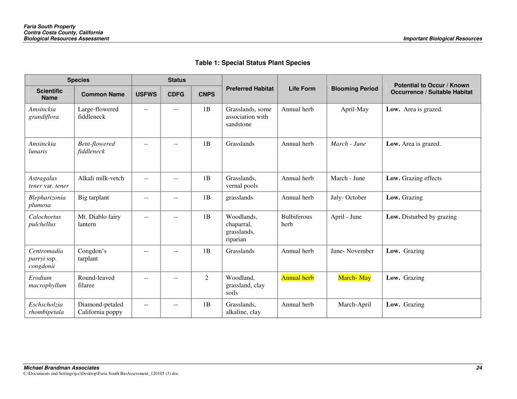
Table 1: Special Status Plant Species
Species Status
Scientific Name Common Name USFWS CDFG CNPS
Preferred Habitat Life Form Blooming Period Potential to Occur / Known Occurrence / Suitable Habitat
Amsinckia grandiflora
Large-flowered fiddleneck
-- -- 1B Grasslands, some association with sandstone
Annual herb April-May Low. Area is grazed.
Amsinckia lunaris
Bent-flowered fiddleneck
-- -- 1B Grasslands Annual herb March - June Low. Area is grazed.
Astragalus tener var. tener
Alkali milk-vetch -- -- 1B Grasslands, vernal pools
Annual herb March - June Low. Grazing effects
Blepharizonia plumosa
Big tarplant -- -- 1B grasslands Annual herb July- October Low. Grazing
Calochortus pulchellus
Mt. Diablo fairy lantern
-- -- 1B Woodlands, chaparral, grasslands, riparian
Bulbiferous herb
April - June Low. Disturbed by grazing
Centromadia parryi ssp. congdonii
Congdon’s tarplant
-- -- 1B Grasslands Annual herb June- November Low. Grazing
Erodium macrophyllum
Round-leaved filaree
-- -- 2 Woodland, grassland, clay soils
Annual herb March- May Low. Grazing
Eschscholzia rhombipetala
Diamond-petaled California poppy
-- -- 1B Grasslands, alkaline, clay
Annual herb March-April Low. Grazing
Fari
a S
outh
Pro
pert
y C
ontr
a C
osta
Cou
nty,
Cal
iforn
ia
Bio
logi
cal R
esou
rces
Ass
essm
ent
Impo
rtan
t Bio
logi
cal R
esou
rces
Mic
hael
Bra
ndm
an A
ssoc
iate
s 25
C
:\Doc
umen
ts a
nd S
ettin
gs\jc
c\D
eskt
op\F
aria
Sou
th B
ioA
sses
smen
t_12
0105
(3).d
oc
Tabl
e 1
(Con
t.): S
peci
al S
tatu
s P
lant
Spe
cies
Spe
cies
S
tatu
s
Sci
entif
ic
Nam
e C
omm
on N
ame
US
FWS
C
DFG
C
NP
S
Pre
ferr
ed H
abita
t Li
fe F
orm
B
loom
ing
Per
iod
Pot
entia
l to
Occ
ur /
Kno
wn
Occ
urre
nce
/ Sui
tabl
e H
abita
t
Fri
tilla
ria
lilia
cea
Frag
rant
friti
llary
--
--
1B
W
oodl
and,
co
asta
l scr
ub,
gras
slan
ds
Pere
nnia
l her
b (b
ulbi
fero
us)
Feb-
Apr
il L
ow.
Gra
zing
Hel
iant
hella
ca
stan
ea
Dia
blo
helia
nthe
lla
--
--
1B
Fore
st, c
hapa
rral
, co
asta
l scr
ub,
gras
slan
ds
Pere
nnia
l her
b A
pril
- Jun
e L
ow.
Gra
zing
Mad
ia r
adia
ta
Show
y m
adia
--
--
1B
W
oodl
and,
gr
assl
ands
A
nnua
l her
b M
arch
– M
ay
Low
. G
razi
ng
Mic
ropu
s am
phib
olus
M
t. D
iabl
o co
ttonw
eed
--
--
3 U
plan
d fo
rest
, w
oodl
and,
gr
assl
and
Ann
ual h
erb
Mar
ch –
May
L
ow.
Gra
zing
Sani
cula
sa
xatil
is
Roc
k sa
nicl
e --
C
R
1B
Upl
and
fore
st,
chap
arra
l, gr
assl
ands
Pere
nnia
l her
b A
pril
– M
ay
Low
. G
razi
ng
Trop
idoc
arpu
m
capp
arid
eum
C
aper
-fru
ited
trop
idoc
arpu
m
--
--
1A
gras
slan
d A
nnua
l her
b M
arch
- Apr
il L
ow.
Gra
zing
. Mau
y be
ext
inct
U.S
. Fis
h an
d W
ildlif
e Se
rvic
e
FE
Fede
ral E
ndan
gere
d FT
Fe
dera
l Thr
eate
ned
PE
Prop
osed
End
ange
red
PT
Prop
osed
Thr
eate
ned
FC
Fede
ral C
andi
date
FS
C
Spec
ies
of C
once
rn*
*No
long
er re
cogn
ized
as
a fe
dera
l des
igna
tion.
Cal
iforn
ia D
epar
tmen
t of F
ish
and
Gam
e
CE
C
alifo
rnia
End
ange
red
CT
C
alifo
rnia
Thr
eate
ned
CR
C
alifo
rnia
Rar
e
Cal
iforn
ia N
ativ
e Pl
ant S
ocie
ty
1A
Plan
ts p
resu
med
ext
inct
in C
alifo
rnia
. 1B
Pl
ants
rare
, thr
eate
ned,
or e
ndan
gere
d in
C
alifo
rnia
and
els
ewhe
re.
2 Pl
ants
rare
, thr
eate
ned,
or e
ndan
gere
d in
C
alifo
rnia
, but
mor
e co
mm
on e
lsew
here
. 3
Plan
ts a
bout
whi
ch w
e ne
ed m
ore
info
rmat
ion.
4
Plan
ts o
f lim
ited
dist
ribut
ion.
Faria South Property Contra Costa County, California Biological Resources Assessment Important Biological Resources
Michael Brandman Associates 26 C:\Documents and Settings\jcc\Desktop\Faria South BioAssessment_120105 (3).doc
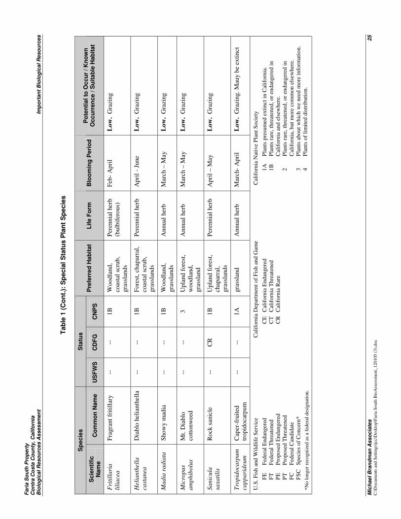
Table 1 (Cont.): Special Status Plant Species
Species Status
Scientific Name Common Name USFWS CDFG CNPS
Preferred Habitat Life Form Blooming Period Potential to Occur / Known Occurrence / Suitable Habitat
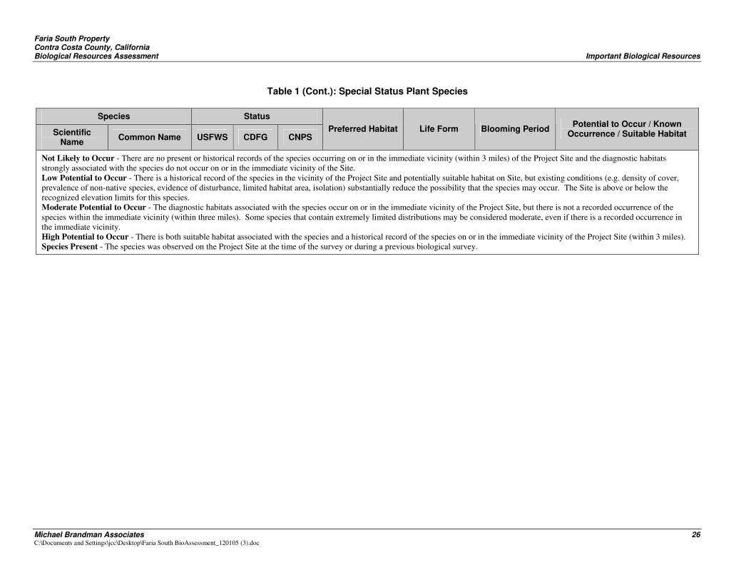
Not Likely to Occur - There are no present or historical records of the species occurring on or in the immediate vicinity (within 3 miles) of the Project Site and the diagnostic habitats strongly associated with the species do not occur on or in the immediate vicinity of the Site. Low Potential to Occur - There is a historical record of the species in the vicinity of the Project Site and potentially suitable habitat on Site, but existing conditions (e.g. density of cover, prevalence of non-native species, evidence of disturbance, limited habitat area, isolation) substantially reduce the possibility that the species may occur. The Site is above or below the recognized elevation limits for this species. Moderate Potential to Occur - The diagnostic habitats associated with the species occur on or in the immediate vicinity of the Project Site, but there is not a recorded occurrence of the species within the immediate vicinity (within three miles). Some species that contain extremely limited distributions may be considered moderate, even if there is a recorded occurrence in the immediate vicinity. High Potential to Occur - There is both suitable habitat associated with the species and a historical record of the species on or in the immediate vicinity of the Project Site (within 3 miles). Species Present - The species was observed on the Project Site at the time of the survey or during a previous biological survey.
Faria South Property Contra Costa County, California Biological Resources Assessment Important Biological Resources
Michael Brandman Associates 27 C:\Documents and Settings\jcc\Desktop\Faria South BioAssessment_120105 (3).doc
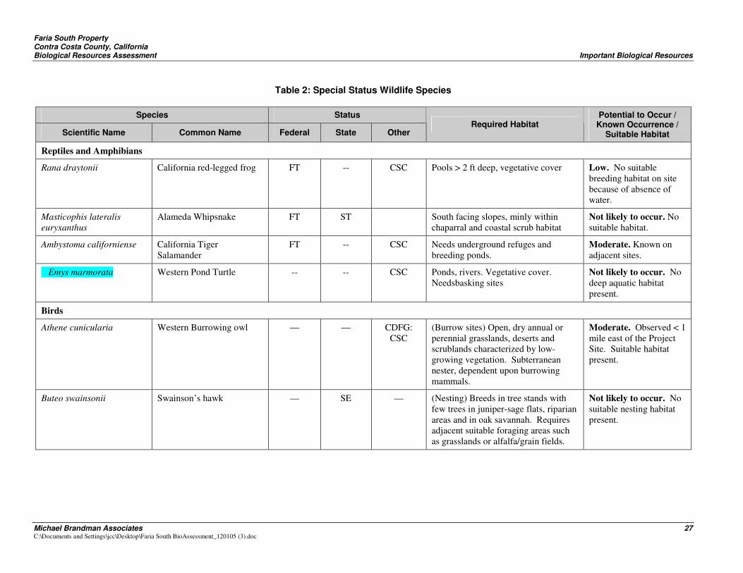
Table 2: Special Status Wildlife Species
Species Status
Scientific Name Common Name Federal State Other Required Habitat
Potential to Occur / Known Occurrence /
Suitable Habitat
Reptiles and Amphibians
Rana draytonii California red-legged frog FT -- CSC Pools > 2 ft deep, vegetative cover Low. No suitable breeding habitat on site because of absence of water.
Masticophis lateralis euryxanthus
Alameda Whipsnake FT ST South facing slopes, minly within chaparral and coastal scrub habitat
Not likely to occur. No suitable habitat.
Ambystoma californiense California Tiger Salamander
FT -- CSC Needs underground refuges and breeding ponds.
Moderate. Known on adjacent sites.
Emys marmorata Western Pond Turtle -- -- CSC Ponds, rivers. Vegetative cover. Needsbasking sites
Not likely to occur. No deep aquatic habitat present.
Birds
Athene cunicularia Western Burrowing owl — — CDFG: CSC
(Burrow sites) Open, dry annual or perennial grasslands, deserts and scrublands characterized by low-growing vegetation. Subterranean nester, dependent upon burrowing mammals.
Moderate. Observed < 1 mile east of the Project Site. Suitable habitat present.
Buteo swainsonii Swainson’s hawk — SE — (Nesting) Breeds in tree stands with few trees in juniper-sage flats, riparian areas and in oak savannah. Requires adjacent suitable foraging areas such as grasslands or alfalfa/grain fields.
Not likely to occur. No suitable nesting habitat present.
Faria South Property Contra Costa County, California Biological Resources Assessment Important Biological Resources
Michael Brandman Associates 28 C:\Documents and Settings\jcc\Desktop\Faria South BioAssessment_120105 (3).doc
Table 2 (Cont.): Special Status Wildlife Species
Species Status
Scientific Name Common Name Federal State Other Required Habitat
Potential to Occur / Known Occurrence /
Suitable Habitat
Reptiles and Amphibians
Aquila chrysaetos Golden eagle -- -- CSC Large areas of grasslands and other habitats, food source of rabbits, hares, ground squirrels
High potential foraging habitat. Observed 2 miles south of the Project Site.
No breeding habitat.
Circus cyaneus Northern Harrier -- -- CSC Annual grasslands, meadows, emergent wetlands
Species present.
Mammals
Vulpes macrotis San Joaquin kit fox FE ST Grasslands with source of rabbits, rodents, and ground squirrel burrows
Low. Have not been observed within 5 miles in many years.
Federal FE Federal Endangered FT Federal Threatened FSC Federal Species of Concern PFT Proposed Federal Threatened C Candidate for Federal Listing
State SE State Endangered ST State Threatened
Other CDFG: CSC California Species of Concern CDFG: FP Fully Protected Species CDFG: P Protected Species
Faria South Property Contra Costa County, California Biological Resources Assessment Important Biological Resources
Michael Brandman Associates 29 C:\Documents and Settings\jcc\Desktop\Faria South BioAssessment_120105 (3).doc
6.3 - WILDLIFE MOVEMENT CORRIDORS
Wildlife movement corridors link areas of suitable wildlife habitat that are otherwise separated by rugged terrain, changes in vegetation, or human disturbance. The fragmentation of open space areas by urbanization creates isolated “islands” of wildlife habitat, separating different populations of a single species. Corridors effectively act as links between these populations. Currently animals can use the Site for localized movement, including movement to and from Concord NWS to the west and to the Keller Landfill and ranching properties to the east and southeast across Bailey Road.
Residential development occurs to the north, northeast and southwest of the Project Site, with limited open space, naval base, and ranching areas occurring on adjacent lands to the west, southeast, and east. Currently many open space properties within the Urban Limit Line are designated for residential development by the City of Pittsburg General Plan, including Bailey Estates along Bailey Road to the east of the Site. This development and the existing heavily used road represent a barrier to movement from the Keller Canyon Landfill open space. The Vista Del Mar and San Marco residential projects, including the future extension of San Marco Boulevard currently under construction represent a barrier to movement to the north, which is predominately urbanized to and beyond State Route 4 freeway. Ultimately, City of Concord development hinders movement to the southwest.
New research on the movements of California red-legged frogs indicates that drainage ways are not necessary to guide movements of migrating frogs of this species. CTS breeding in ponds on Concord NWS may migrate within one mile into the Project Site and may use the two man-made mitigation features noted above.
The movement of wildlife species is limited to localized movement in the immediate vicinity, but not regional of the Project Site. This is due to existing and probable future barriers (urban development and highway improvements) in the City of Pittsburg and ultimately in the City of Concord with base realignment and redevelopment.
6.4 - RESOURCE ASSESSMENT CONCLUSIONS
This biological resource assessment provides baseline information about the existing and potential biological resources on the Site. Further, this analysis also focused on determining the biological sensitivity of the majority of the Site within the proposed East Contra Costa County Draft Habitat Conservation Plan and Natural Community Conservation Plan (HCP/NCCP) area.
Faria South Property Contra Costa County, California Biological Resources Assessment Important Biological Resources
Michael Brandman Associates 30 C:\Documents and Settings\jcc\Desktop\Faria South BioAssessment_120105 (3).doc
Overall, the Project Site is heavily disturbed as a result of many years of cattle grazing and ranching. The Site is located on topographic terrain south and west of an area of expanding suburban development. It is dominated by a cover of grazed non-native grassland, consisting of common introduced grasses and forbs. Two small man –made mitigation features that were constructed for mitigation of filled wetlands at another property are located near the northwest border of the Site. Ephemeral unnamed drainage features heavily damaged by cattle ranching activities are predominantly in the northern and eastern portions of the site. These are typically used as cattle paths with ground cover of non-native grasses undifferentiated from surrounding slopes.
The Project Site provides suitable habitat for several special status species of plants and animals. The only sensitive plant community known to occur on the Project Site is the man-made mitigation features constructed as part of a mitigation plan for loss of jurisdictional wetlands. These areas are fenced and posted as protected sites and are managed for maintenance of wetland vegetation and habitat (James Coniglio, Discovery Homes, personal communication 2005).
Fourteen sensitive plant species, known from grassland habitats within a 10-mile radius of the Site, are not expected to occur. Focused surveys during the blooming period of these plants will be conducted to better determine their presence or absence.
Of the thirty-five sensitive wildlife species known to be present within a 10-mile radius of the Project Site, nine were chosen for further evaluation after eliminating those that have habitat requirements not available on the Project Site. Of these, two common sensitive wildlife species, loggerhead shrike (Lanius ludovicianus) and Northern harrier (Circus cyaneus) were observed on the Project Site. A discussion of each sensitive wildlife species recognized from the literature and MBA’s assessment as potentially present on the Site is presented in Table 2.
Portions of the Site contain known habitat for two sensitive wildlife species, the Northern Harrier and loggerhead shrike, which were observed during field surveys. Portions of the Site also contain potentially suitable habitat for five additional sensitive wildlife species: federally endangered San Joaquin kit fox, federally threatened California red-legged frog, federally threatened California tiger salamander (CTS), Golden eagles, and Western burrowing owl. The federally threatened California red-legged frog is known to utilize nearby ponds adjacent to the Project Site. Because they are known to travel over land, they may have potential to be found within grasslands on the site in proximity to the ponds. The CTS is known to occur on Concord NWS to the west and to the north of the Site. In addition, they could possibly breed within the small man-made mitigation features located on northern perimeter of the Site. The CTS spend most of the year within underground refuges, especially those excavated by gophers and ground squirrels, both of which are present on the
Faria South Property Contra Costa County, California Biological Resources Assessment Important Biological Resources
Michael Brandman Associates 31 C:\Documents and Settings\jcc\Desktop\Faria South BioAssessment_120105 (3).doc
Project Site. Golden eagles were observed two miles southeast of the Project Site in similar grazed annual grasslands. This species is known to nest at the Concord Naval Weapons Station (NWS) on land immediately adjacent to the west and would be likely to forage for prey within the Project Site. However, there is not suitable nesting habitat on the Site. The Western burrowing owl has been documented in habitats similar to those on the Project Site on lands immediately adjacent to the west and to the southeast, although none were observed during the site surveys. The San Joaquin kit fox is known from historic records to have occurred on lands 5 miles east of the Project Site. There are no known occurrences of the kit fox in recent times within the site or in the general vicinity of the Site, and therefore there is a very low expectation that the species is currently present, in addition to the fact the there is a relatively large population of known predators (Golden Eagle and Coyotes).
The Project Site contains ephemeral drainages with relatively small tributary areas that flow into several different surface waters. One ephemeral drainage with a relatively small tributary area drains to the west into the Clayton Canal, and eventually into Mt. Diablo Creek within Concord NWS. The other ephemeral unnamed drainages flow to the north, including one unnamed drainage that flows to the north through existing development, and another unnamed drainage that flows to the north to several other unnamed drainages, and eventually into Willow Creek north east of the Site.
Two small man-made mitigation features (approximately 2.3 acres), constructed as mitigation for wetlands losses at the Oak Hill development, contain seasonal wetlands. One feature is located on the San Marco Meadows property upstream of the other feature which is located on the Project Site. They are both located in the proposed ECCC HCP Subzone 1a High Acquisition Priority (HAP). These features and potentially lower reaches of the drainage feature may fall under the jurisdiction of the United States Army Corps of Engineers (USACE), Regional Water Quality Control Board (RWQCB), and California Department of Fish and Game (CDFG).
The Project Site lies between undeveloped lands to the west (comprising Concord NWS) and to the southeast that may allow movements of relatively mobile species across the Site from east to west. However, the lands north, northeast and southeast of the Site are developed or under development.
Residential development occurs to the north, northeast and southwest of the Project Site, with limited open space, naval base, and ranching areas occurring on adjacent lands to the west, southeast, and east. Currently many open space properties within the Urban Limit Line are designated for residential development by the City of Pittsburg General Plan, including Bailey Estates along Bailey Road to the east of the Site. This development and the existing heavily used road represent a barrier to movement from the Keller Canyon Landfill open space. The Vista Del Mar and San Marco residential projects
Faria South Property Contra Costa County, California Biological Resources Assessment Important Biological Resources
Michael Brandman Associates 32 C:\Documents and Settings\jcc\Desktop\Faria South BioAssessment_120105 (3).doc
currently under construction represent a barrier to movement to the north, which is predominately urbanized to and beyond State Route 4 freeway. Ultimately, City of Concord development hinders movement to the southwest.
The movement of wildlife species is limited to localized movement in the immediate vicinity of the Project Site. This is due to existing and probable future barriers (urban development and highway improvements) in the City of Pittsburg and ultimately in the City of Concord with base realignment and redevelopment.
Focused surveys are recommended to determine the presence of sensitive plant species listed in Table 1 that are considered of special concern and are potentially on the Project Site. Focused protocol surveys are recommended for California Tiger Salamander, Red-legged Frog, and Burrowing Owl.
Faria South Property Contra Costa County, California Biological Resources Assessment Biological Analysis of Faria South Property
Michael Brandman Associates 33 C:\Documents and Settings\jcc\Desktop\Faria South BioAssessment_120105 (3).doc
SECTION 7: BIOLOGICAL ANALYSIS OF FARIA SOUTH PROPERTY IN RELATION TO THE
PROPOSED EAST CONTRA COSTA COUNTY HABITAT CONSERVATION PLAN AND NATURAL COMMUNITY CONSERVATION PLAN
7.1 - INTRODUCTION
This analysis focuses on assessing the biological sensitivity of the Faria South property within the proposed East Contra Costa County Habitat Conservation Plan and Natural Community Conservation Plan (HCP/NCCP) High Priority Acquisition Area.
7.1.1 - Location
The Project Site is in unincorporated Contra Costa County, adjacent to the City of Pittsburg. The property is shaped in a series of northwest-to-southeast trending triangles, with the bulk of the land area concentrated in the southeastern portion of the property. The Site is bounded by Seal Beach Naval Weapons Station, Concord Navel Weapons Station (NWS) (west and south), the existing San Marco development in the City of Pittsburg (north), and the proposed Bailey Estates property (south).
7.1.2 - General Plan Land Use Designations
The Project Site is within unincorporated Contra Costa County and within the Planning Area of the City of Pittsburg. The property is pre-zoned for development, and within the City of Pittsburg Urban Limit Line. The Contra Costa County General Plan land use designation for the Site is agriculture. The City of Pittsburg General Plan land use designation for the property is low-density residential and low-density hillside residential. The City of Pittsburg General Plan will govern the land uses of the subject property upon annexation.
7.1.3 - Pittsburg Urban Limit Line
As stipulated in the requirements of Measure J, which was approved by more than 70% of Contra Costa County voters in November 2004, each city in the eastern portion of the County must adopt and maintain an Urban Limit Line. New urban development is effectively precluded outside of the Urban Limit Line. In November 2005, Pittsburg voters approved Measure P, which adjusted the Pittsburg Urban Limit Line to bring the Faria South property within the City’s Urban Limit Line.
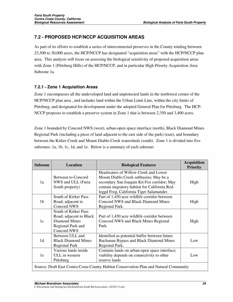
Faria South Property Contra Costa County, California Biological Resources Assessment Biological Analysis of Faria South Property
Michael Brandman Associates 34 C:\Documents and Settings\jcc\Desktop\Faria South BioAssessment_120105 (3).doc
7.2 - PROPOSED HCP/NCCP ACQUISITION AREAS
As part of its efforts to establish a series of interconnected preserves in the County totaling between 23,500 to 30,000 acres, the HCP/NCCP has designated “acquisition areas” with the HCP/NCCP plan area. This analysis will focus on assessing the biological sensitivity of proposed acquisition areas with Zone 1 (Pittsburg Hills) of the HCP/NCCP, and in particular High Priority Acquisition Area Subzone 1a.
7.2.1 - Zone 1 Acquisition Areas
Zone 1 encompasses all the undeveloped land and unprotected lands in the northwest corner of the HCP/NCCP plan area , and includes land within the Urban Limit Line, within the city limits of Pittsburg, and designated for development under the adopted General Plan for Pittsburg. The HCP-NCCP proposes to establish a preserve system in Zone 1 that is between 2,350 and 3,400 acres.
Zone 1 bounded by Concord NWS (west), urban-open space interface (north), Black Diamond Mines Regional Park (including a piece of land adjacent to the east side of the park) (east), and boundary between the Kirker Creek and Mount Diablo Creek watersheds (south). Zone 1 is divided into five subzones: 1a, 1b, 1c, 1d, and 1e. Below is a summary of each subzone:
Subzone Location Biological Features Acquisition Priority
1a Between to Concord NWS and ULL (Faria South property)
Headwaters of Willow Creek and Lower Mount Diablo Creek subbasins; May be a secondary San Joaquin Kit Fox corridor; May contain migratory habitat for California Red-leggd Frog, California Tiger Salamander.
High
1b South of Kirker Pass Road; adjacent to Concord NWS
Part of 1,450 acre wildlife corridor between Concord NWS and Black Diamond Mines Regional Park.
High
1c
South of Kirker Pass Road; adjacent to Black Diamond Mines Regional Park and Concord NWS
Part of 1,450 acre wildlife corridor between Concord NWS and Black Mines Regional Park.
High
1d Between ULL and Black Diamond Mines Regional Park
Identified as potential buffer between future Buchanan Bypass and Black Diamond Mines Regional Park.
Low
1e Various lands inside ULL in western Pittsburg
Contains lands on urban-open space interface; viability depends on connectivity to other reserve lands
Low
Source: Draft East Contra Costa County Habitat Conservation Plan and Natural Community
Faria South Property Contra Costa County, California Biological Resources Assessment Biological Analysis of Faria South Property
Michael Brandman Associates 35 C:\Documents and Settings\jcc\Desktop\Faria South BioAssessment_120105 (3).doc
Conservation Plan. 2005.
7.2.2 - Preserve Acquisition Criteria
All of the undeveloped land inside the plan area is given an acquisition priority: high, medium, or low. Below is a description of how the acquisition priorities were determined, as excerpted from Page 5-19 of the HCP/NCCP:
Preserve Acquisition Priorities Acquisition priorities within each zone were based on the ecological and conservation opportunities with each zone for achieving the biological goals and objectives for covered species and natural communities. Factor that affect conservation opportunities include land cover type, extent, and distribution; existing land use patterns, and planned future land use activities. Land was given a higher priority for acquisition if it met more of the preserve design criteria, provided or could provide through restoration the habitat requirements for one or more covered species, and provided the needs of one of the key covered species.
Pre-Acquisition Surveys
The Implementing Entity will conduct pre-acquisition surveys on potential preserve lands to evaluate whether these lands will meet the requirements of the HCP/NCCP. Once the Implementing Entity has entered into an agreement with a landowner interested in selling land for the Preserve System, qualified biologists will conduct a pre-acquisition survey to determine the suitability of the site for the Preserve System. Types of information collected during these surveys will include an assessment of location, quantity, quality, and type of covered species, habitat, and natural communities present on the surveyed lands, as well as other site conditions and infrastructure that would benefit or conflict with the preserve’s biological goals and objectives. This information will help the Implementing Entity prioritize acquisition of preserve lands based on their relative contribution toward meeting the biological goals and objectives.
7.2.3 - Acquisition Requirements for Zone 1
The proposed HCP/NCCP sets forth the following acquisition requirements for Zone 1:
� Acquire at least 300 acres of annual grassland in Subzone 1a to protect ridgelines and the upper watershed of Willow Creek and Lower Mount Diablo Creek subbasins.
� Acquire at least 1,450 acres in Subzones 1b and 1c to connect Black Diamond Mines Regional Park with Concord NWS and preserve habitat for the California Red-legged Frog, California Tiger Salamander, western pond turtle, and other covered species.
Faria South Property Contra Costa County, California Biological Resources Assessment Biological Analysis of Faria South Property
Michael Brandman Associates 36 C:\Documents and Settings\jcc\Desktop\Faria South BioAssessment_120105 (3).doc
� Acquire at least 25% of Subzone 1d to compliment the corridor between Black Diamond Mines Regional Park with Concord NWS.
� Land outside Concord NWS blast easements should be acquired before land inside blast easements because it is already protected from development.
� There is no land acquisition requirement for Subzone 1e because of planned urban uses; however, if land is acquired, it must be contiguous with other preserve lands or Concord NWS.
7.3 - SUMMARY OF BIOLOGICAL FEATURES ON THE FARIA SOUTH PROPERTY
Michael Brandman Associates (MBA) prepared a biological resources assessment of the Site as described above in Section 1 through 6 above.
From this assessment, the following biological findings were made:
1. The Project Site vegetation is comprised entirely of heavily grazed (non-native) grassland Series consisting primarily of non-native species with the exception of two man-made mitigation features established as mitigation in the far northwestern corner of the Site.
2. All the drainages onsite are ephemeral and have been heavily impacted by cattle grazing. They show very little evidence of any riparian vegetation, let alone well define bed and bank.
3. All drainages flowing toward the north and east are converted to man-made and existing storm drain facilities culverts through existing residential developments in the City of Pittsburg.
4. The Site represents a very small portion 0.9% of the Willow Creek subbasin and 0.8% of the upper Mt. Diablo Creek subbasin.
5. A small drainage within the Mt. Diablo watershed ultimately drains into the Clayton Canal, a man-made and improved feature in Concord NWS.
Faria South Property Contra Costa County, California Biological Resources Assessment Biological Analysis of Faria South Property
Michael Brandman Associates 37 C:\Documents and Settings\jcc\Desktop\Faria South BioAssessment_120105 (3).doc
6. There are no wildlife corridor for any covered species, including the San Joaquin Kit Fox, on the Project Site. The Site may currently be used for localized movement, but will be constrained by the development of Bailey Estates.
7. There are potential localized, habitat connections between proposed CTS ponds in the Vista Del Mar (Alves) open space north of the site to existing cattle ponds potentially containing CTS west of the Site on Concord NWS, although the extension of San Marco Blvd. will be a barrier to this connection,
8. Existing and proposed residential development and infrastructure (including the extension of San Marco Blvd.) to the north, east, and south of the Site represent major barriers to movement of covered species from other existing or potential preserve areas.
9. The Site contains potential upland habitat that might be used by CTS from neighboring areas.
10. The Site may provide movement opportunity for red legged frog, which has recently been found to use upland areas for movement, but does not contain suitable breeding habitat.
11. The Site contains potential burrowing owl habitat.
Based on a comparison of the conclusions of the biological assessment to the HCP/NCCP conservation strategy objectives underlying the designation of high priority acquisition areas, the Project Site does not meet the following HCP/NCCPconservation strategy objectives (Page 5-3 of the draft HCP/NCCP):
a. Conserves, restores, and provides for the management of representative natural and semi-natural landscapes: The site represents a homogeneous non-native annual grassland surrounded by existing or planned urban development on three sides. The Site does not exhibit unique resources value in that thousands of acres of similar habitat and terrain are in existing open space and/or identified as High Priority Acquisition areas in Zone 1b, 1c, 2a, and 2b.
Faria South Property Contra Costa County, California Biological Resources Assessment Biological Analysis of Faria South Property
Michael Brandman Associates 38 C:\Documents and Settings\jcc\Desktop\Faria South BioAssessment_120105 (3).doc
b. Establishes preserves that provide conservation of covered species within the inventory area and linkages to adjacent outside the inventory area: The Site does not support known or breeding habitat for populations of covered species, in particular CTS, CRLF, and San Joaquin Kit Fox. The Site may support localized movement of CTS and CRLF now, or when future mitigation sites are created, but this is not a unique resources value in light of the fact that these species will generally use non-native grassland for movement, which is prevalent in existing open space and/or other High Priority Acquisition areas, including Zone 1b,1c, 2a, and 2b. Further, the Site is separated from other proposed preserve areas. While the Site is adjacent to the Concord NWS to the west, which is currently characterized by open space, the base closure and local land use planning process currently indicates that future development will occur in this area.
c. Protects and maintains habitat that are large enough to support sustainable populations of covered species. There is no known evidence that the Site currently supports sustainable populations of covered species, nor is large enough to support populations if they did exist. With respect to listed covered species, the site does not currently support breeding habitat for red-legged frog, kit fox, or other species, and the potential breeding habitat for CTS is limited to the man-made mitigation features.
d. Incorporates a range of environmental gradients and high habitat diversity to provide for shifting species distributions due to changing circumstances: The site is homogenous non-native annual grassland and does not contain any of these characteristics.
e. Sustains the effective movement and interchange of organisms between habitat areas in a manner that maintains the ecological integrity of the Preserve System. Based on the vegetation, habitat, drainage characteristics, and given that the Site is surrounded on three sides by existing and future planned and approved development, the Site cannot meet this objective, and at best provides for localized movement only.
The Project Site does not meet the following principles of conservation biology to guide the design criteria for the Preserve System (pages 5-10 through 5-12 of the draft ECCC HCP):
a. Maximum Size
Faria South Property Contra Costa County, California Biological Resources Assessment Biological Analysis of Faria South Property
Michael Brandman Associates 39 C:\Documents and Settings\jcc\Desktop\Faria South BioAssessment_120105 (3).doc
b. Preserve the Highest-Quality Communities
c. Link Preserves
d. Buffer Urban Impacts
e. Minimize Edge
f. Fully Represent Environmental gradients
g. Consider watersheds
h. Consider full ecological diversity within communities
i. Consider Management needs
7.4 - CONCLUSIONS REGARDING SUBZONE 1A HIGH PRIORITY ACQUISITION DESIGNATION
As described above in Section 3, there is scientific evidence refutes some of the key and biological assumptions made in the HCP/NCCP, particularly as they relate to the proposed designation of Zone 1a as a higher priority acquisition area exhibiting high resource value.
The HCP/NCCP designates the Faria South property as a high priority acquisition area because of the possible presence of a San Joaquin Kit Fox corridor and migratory habitat for the California Red-legged Frog and the California Tiger Salamander. The HCP/NCCP acknowledges the uncertainty of the presence of these biological features with the words “may be” or “may contain” before each item. Since the HCP/NCPP is prepared based upon literature review and landscape level assessment of habitat resources, the site specific biological assessment conducted for this acquisition areas provides more reliable site specific information regarding the biological resources of Faria South property. The Site specific biological assessment demonstrates that the HCP/NCCP’s assumptions made about the biological significance of Subzone 1a do not accurately portray the resource value of the Site, or the contribution that the Site will make to the HCP/NCCP.
Faria South Property Contra Costa County, California Biological Resources Assessment Biological Analysis of Faria South Property
Michael Brandman Associates 40 C:\Documents and Settings\jcc\Desktop\Faria South BioAssessment_120105 (3).doc

Faria South Property Contra Costa County, California Biological Resources Assessment References
Michael Brandman Associates 41 C:\Documents and Settings\jcc\Desktop\Faria South BioAssessment_120105 (3).doc
SECTION 8: REFERENCES
American Ornithologists’ Union. 1983 (and supplements 1985, 1987, 1989, 1991, 1993, and 1995). The A.O.U. Check-List of North American Birds. 6th ed. Allen Press. Lawrence, Kansas.
Bulger, J.B., N.J. Scott, and R.B. Seymour. 2003. Terrestrial activity and conservation of adult California red-legged frogs Rana ayrora draytonii in coastal forests and grasslands. Biol. Cons. 110: 85-95.
Burt, W. H., and Grossenheider, R. P., 1980. Peterson Field Guides, Mammals. Houghton Mifflin Company. New York, New York.
California Department of Fish and Game (CDFG), 2004 (July). State and Federally Listed Endangered, Threatened, and Rare Plants of California. The Resources Agency State of California, Department of Fish and Game, Natural Heritage Division, Natural Diversity Data Base. Sacramento, California.
California Department of Fish and Game (CDFG), 2004 (August). Special Animals. The Resources Agency State of California, Department of Fish and Game, Natural Heritage Division, Natural Diversity Data Base. Sacramento, California.
California Department of Fish and Game (CDFG). 2004 (July). Natural Communities. California Department of Fish and Game, Natural Diversity Data Base. The Resources Agency of California. Sacramento, California. 119 pp.
California Department of Fish and Game (CDFG). 2004 (July). Special Plants List. California Department of Fish and Game, Natural Diversity Data Base. The Resources Agency of California. Sacramento, California. 119 pp.
California Department of Fish and Game. 1988a. California’s Wildlife. Volume I: Amphibians and Reptiles. State of California Resources Agency. Sacramento, California.
California Department of Fish and Game. 1988b. California’s Wildlife. Volume II: Birds. State of California Resources Agency. Sacramento, California.
California Department of Fish and Game. 1988c. California’s Wildlife. Volume III: Mammals. State of California Resources Agency. Sacramento, California.
California Native Plant Society. 2005. California Native Plant Society’s Electronic Inventory of Rare and Endangered Vascular Plants of California. Retrieved from http://www.northcoast.com/~cnps/cgi-bin/cnps/sensinv.cgi.
California, State of. 1989. Fish And Game Code.
City of Pittsburg, 2004. Environmental Impact Report for the Vista Del Mar Project (Alves Ranch).
Faria South Property Contra Costa County, California Biological Resources Assessment References
Michael Brandman Associates 42 C:\Documents and Settings\jcc\Desktop\Faria South BioAssessment_120105 (3).doc
Clark, Jr., H. O., D. A. Smith, B. L. Cypher, and P. A. Kelly. 2003. Detection dog surveys for San Joaquin kit foxes in the northern range. Prepared for Pacific Gas & Electric Company Technical and Ecological Services, San Ramon, CA.
Department of Army. 1986 (Nov 13). 33 CFR Parts 320 Through 330, Regulatory Programs of the Corps of Engineers; Final Rule. Federal Register. 51(219): 41206-260.
Department of Army. 2000 (Mar 9). 33 CFR Parts 320 Through 330, Regulatory Programs of the Corps of Engineers; Final Rule. Federal Register. Vol. 65 No. 47: 12818-899.
Department of Army. 2002 (Jan 15). 33 CFR Parts 320 Through 330, Regulatory Programs of the Corps of Engineers; Final Rule. Federal Register. Vol. 67 No. 10: 2020-2095.
Hickman, J. C. 1993. The Jepson Manual: Higher Plants of California. University of California Press. Berkeley, California.
Holland, R.F. 1986. Preliminary Descriptions of the Terrestrial Natural Communities of California. Non-game Heritage Program. California Department of Fish and Game. Sacramento, California.
Jones and Stokes. 2005. East Contra Costa County Habitat Conservation Plan and Natural Community Conservation Plan. Draft. June. (J&S 01478.01) San Jose, CA.
Klute, D. S., L. W. Ayers, M. T. Green, W. H. Howe, S. L. Jones, J. A. Shaffer, S. R. Sheffield, and T. S. Zimmerman. 2003. Status assessment and conservation plan for the western burrowing owl in the United States. U.S. Department of Interior, Fish and Wildlife Service, Biological Technical Publication FWS/BTP-R6001-2003, Washington, D.C.
National Geographic Society. 1987. National Geographic Society Field Guide to the Birds of North America. 2nd Edition. National Geographic Society, Washington D.C.
Reed, P.B. 1988. National List of Plant Species That Occur in Wetlands: California (Region 0). National Wetlands Inventory, U.S. Fish and Wildlife Service Biological Report 88 (26.9).
Sawyer, J.O. and T. Keeler-Wolf. 1995. A Manual of California Vegetation. California Native Plant Society. Sacramento, California.
Stebbins, R. C. 2003. A Field Guide to Western Reptiles and Amphibians. 2nd. Ed. Houghton-Mifflin Company. Boston, Massachusetts.
Swaim K. E. 1994. Aspects of the ecology of the Alameda whipsnake. (Masticophis lateralis euryxanthus). Masters Thesis, California State University, Hayward, CA. 140 pp.
Tetra Tech, Inc. 2002. Final Integrated Natural Resources Management Plan for the Naval Weapons Station Seal Beach Concord NWS. March 2002
Tibor, D. P. 2001. California Native Plant Society’s Inventory of Rare and Endangered Plants of California. California Native Plant Society. Special Publication, No. 1, 6th ed.
Faria South Property Contra Costa County, California Biological Resources Assessment References
Michael Brandman Associates 43 C:\Documents and Settings\jcc\Desktop\Faria South BioAssessment_120105 (3).doc
Udvardy, M.D. 1994. National Audubon Society Field Guide to North American Birds. Alfred A. Knopf, Inc. New York, New York.
U.S. Department of Agriculture. 1970. Soil Survey ofContra Costa County, California. Department of the Interior. U.S. Government Printing Office. Washington, D.C.
U.S. Fish and Wildlife Service (USFWS). 1993 (Sep 30). Plant Taxa for Listing as Endangered or Threatened Species; Notice of Review. Federal Register 50 CFR Part 17. U.S. Department of the Interior. Washington, DC.
U.S. Fish and Wildlife Service. 1994 (Nov 15). Endangered and Threatened Wildlife and Plants; Animal Candidate Review for Listing as Endangered or Threatened Species. Federal Register 50 CFR Part 17. U.S. Department of the Interior. Washington, DC.
U.S. Fish and Wildlife Service. 1997c (Oct. 31). Endangered and Threatened Wildlife and Plants. Federal Register 50 CFR Part 17.11 and 17.12. U.S. Department of the Interior. Washington, DC.
United States Army Corps of Engineers, 1987. Wetlands Delineation Manual, Technical Report Y-87-1, U.S. Army Engineer waterways Experiment Station Vicksburg, Miss.
Faria South Property Contra Costa County, California Biological Resources Assessment Project Responsibility
Michael Brandman Associates 44 C:\Documents and Settings\jcc\Desktop\Faria South BioAssessment_120105 (3).doc
SECTION 9: PROJECT RESPONSIBILITY
Principal-In-Charge ........................................................................................ Michael Brandman, Ph.D. Biological Resources Assessment Report: Primary Author ........................................Michael Marangio Technical Review of Biological Resources Assessment ........................................... Tom McGill, Ph.D.
Faria South Property Contra Costa County, California Biological Resources Assessment Appendix A
Michael Brandman Associates A-1 C:\Documents and Settings\jcc\Desktop\Faria South BioAssessment_120105 (3).doc
Appendix A: Floral Compendium
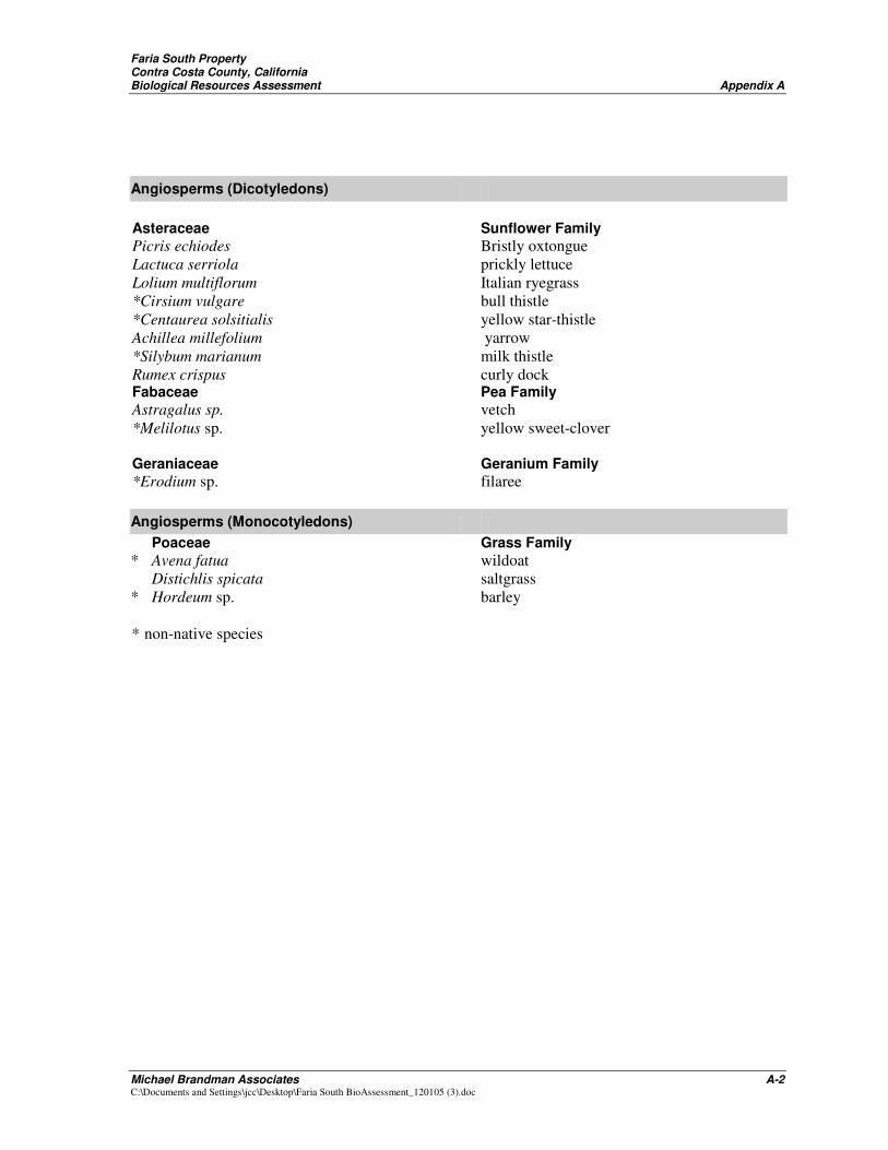
Faria South Property Contra Costa County, California Biological Resources Assessment Appendix A
Michael Brandman Associates A-2 C:\Documents and Settings\jcc\Desktop\Faria South BioAssessment_120105 (3).doc
Angiosperms (Dicotyledons) Asteraceae Sunflower Family *Picris echiodes Bristly oxtongue *Lactuca serriola prickly lettuce Lolium multiflorum Italian ryegrass *Cirsium vulgare bull thistle *Centaurea solsitialis yellow star-thistle Achillea millefolium yarrow *Silybum marianum milk thistle Rumex crispus curly dock Fabaceae Pea Family Astragalus sp. vetch **Melilotus sp. yellow sweet-clover Geraniaceae Geranium Family **Erodium sp. filaree Angiosperms (Monocotyledons) Poaceae Grass Family * Avena fatua wildoat Distichlis spicata saltgrass * Hordeum sp. barley * non-native species