Embed Size (px)
Citation preview
Dinesh Manandhar, CSIS, The University of Tokyo, [email protected] : 1
MGA Webinar Series : 8GNSS Raw Data Measurement from Android Device
Dinesh ManandharCenter for Spatial Information Science
The University of Tokyo
Contact Information: [email protected]
6th Dec 2018
Dinesh Manandhar, CSIS, The University of Tokyo, [email protected] : 2
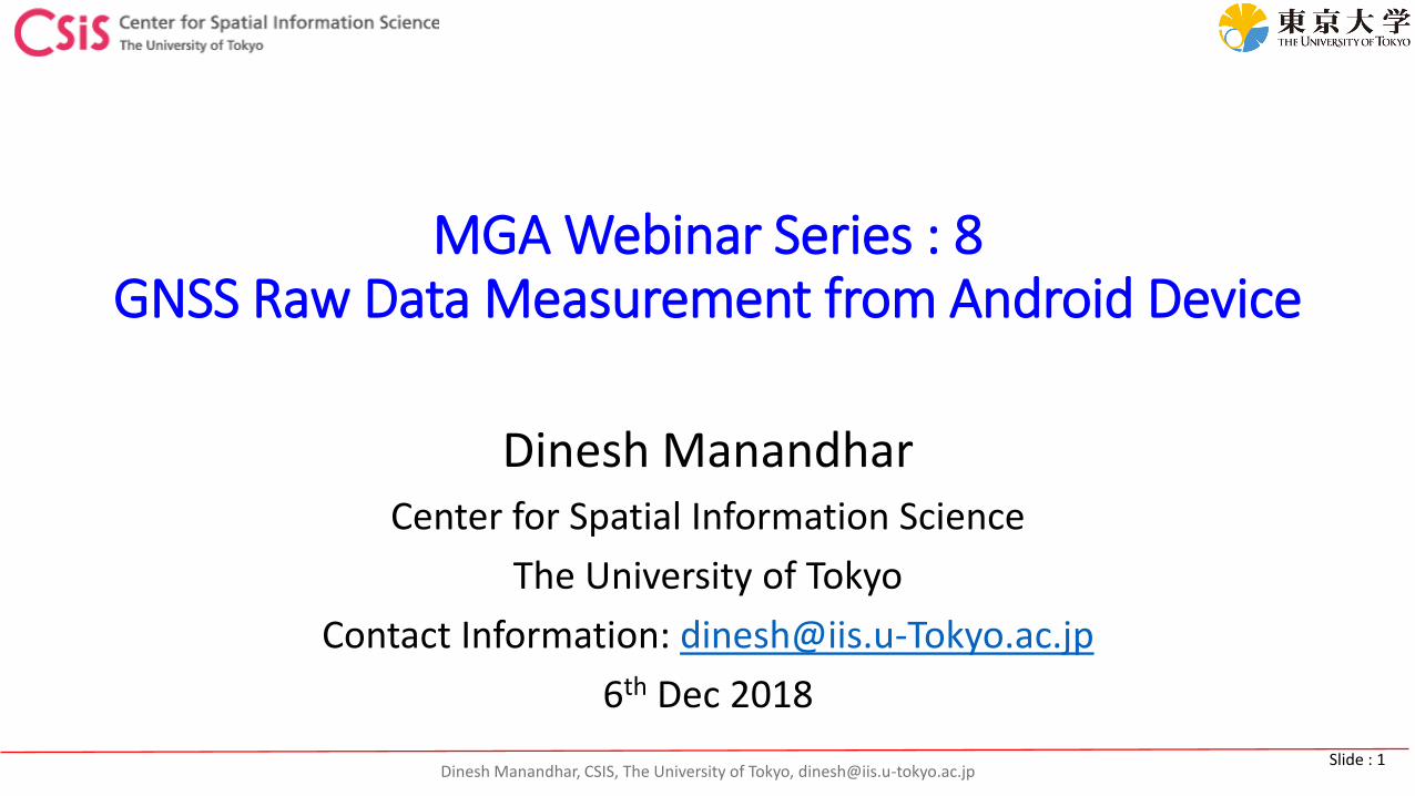
Android Raw Data Logging APPs
• GNSS Logger• Logs Raw Data• Some devices also output AGC and Navigation Bit Data• Multi Band Compatible
• Geo++ RINEX Logger• APP to generate RINEX Observation File
• https://play.google.com/store/apps/details?id=de.geopp.rinexlogger&hl=en_US• Dual Frequency Compatible
• GNSS Compare• Compares position accuracy from each type of GPS and GALILEO Signal
• https://play.google.com/store/apps/details?id=com.galfins.gnss_compare&hl=en_US

Dinesh Manandhar, CSIS, The University of Tokyo, [email protected] : 3
Android Raw Data Logging APP: GnssLogger
Dinesh Manandhar, CSIS, The University of Tokyo, [email protected] : 4
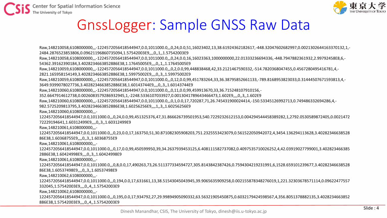
GnssLogger: Sample GNSS Raw DataRaw,148210058,6108000000,,,-1224572056418544947,0.0,1011000.0,,,0,24,0.0,51,16023402,13,38.61924362182617,-448.32047602682997,0.0021302644163370132,1,-2484.2876523853806,0.09621196860735094,1.57542003E9,,,,0,,1,,1.57542003E9Raw,148210058,6108000000,,,-1224572056418544947,0.0,1011000.0,,,0,24,0.0,16,16023363,1000000000,22.01333236694336,-448.7947882361932,2.99792458E8,6,-54362.39162390184,3.4028234663852886E38,1.17645005E9,,,,0,,1,,1.17645005E9Raw,148210059,6108000000,,,-1224572056418544947,0.0,1011000.0,,,0,2,0.0,99,448838468,42,33.2121467590332,-514.7820368047455,0.4567280495416781,4,-2821.165958154149,3.4028234663852886E38,1.59975002E9,,,,0,,3,,1.59975002E9Raw,148210059,6108000000,,,-1224572056418544947,0.0,1011000.0,,,0,12,0.0,99,451783264,33,36.38795852661133,-789.8168953823033,0.31444507671593813,4,-3649.9399078027736,3.4028234663852886E38,1.60143744E9,,,,0,,3,,1.60143744E9Raw,148210060,6108000000,,,-1224572056418544947,0.0,1011000.0,,,0,11,0.0,99,459913670,33,36.715248107910156,-352.6647914612738,0.0026083579286932945,1,-2248.5336107033927,0.0013041789643466473,1.602E9,,,,0,,3,,1.602E9Raw,148210060,6108000000,,,-1224572056418544947,0.0,1011000.0,,,0,1,0.0,17,720287,71,26.745431900024414,-150.53345126992713,0.749486332694286,4,-982.5725209813795,3.4028234663852886E38,1.60256256E9,,,,1,,3,,1.60256256E9Raw,148210060,6108000000,,,-1224572056418544947,0.0,1011000.0,,,0,24,0.0,99,451325376,47,31.866626739501953,540.7229232612153,0.004294544458389282,1,2792.0530589872405,0.002147272229194641,1.60312499E9,,,,0,,3,,1.60312499E9Raw,148210061,6108000000,,,-1224572056418544947,0.0,1011000.0,,,0,23,0.0,17,163750,51,30.871082305908203,751.2325553423079,0.561522050942072,4,3454.136294113628,3.4028234663852886E38,1.60368755E9,,,,0,,3,,1.60368755E9Raw,148210061,6108000000,,,-1224572056418544947,0.0,1011000.0,,,0,17,0.0,99,450599950,39,34.2637939453125,6.408111582737082,0.4097535710026252,4,42.03919027799001,3.4028234663852886E38,1.60424998E9,,,,0,,3,,1.60424998E9Raw,148210061,6108000000,,,-1224572056418544947,0.0,1011000.0,,,0,8,0.0,17,490263,73,26.511377334594727,305.8143842387426,0.7594304219231991,6,1528.659101239677,3.4028234663852886E38,1.60537498E9,,,,0,,3,,1.60537498E9Raw,148210062,6108000000,,,-1224572056418544947,0.0,1011000.0,,,0,194,0.0,17,631661,13,38.51543045043945,39.9065635909258,0.002155878348276019,1,221.32303678571114,0.09622477557332045,1.57542003E9,,,,0,,4,,1.57542003E9Raw,148210062,6108000000,,,-1224572056418544947,0.0,1011000.0,,,0,195,0.0,17,934792,27,29.99894905090332,63.56321905450875,0.6032179424598567,4,356.8051378882135,3.4028234663852886E38,1.57542003E9,,,,0,,4,,1.57542003E9
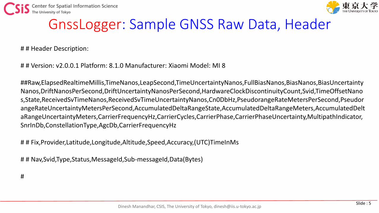
Dinesh Manandhar, CSIS, The University of Tokyo, [email protected] : 5
GnssLogger: Sample GNSS Raw Data, Header
# # Header Description:
# # Version: v2.0.0.1 Platform: 8.1.0 Manufacturer: Xiaomi Model: MI 8
##Raw,ElapsedRealtimeMillis,TimeNanos,LeapSecond,TimeUncertaintyNanos,FullBiasNanos,BiasNanos,BiasUncertaintyNanos,DriftNanosPerSecond,DriftUncertaintyNanosPerSecond,HardwareClockDiscontinuityCount,Svid,TimeOffsetNanos,State,ReceivedSvTimeNanos,ReceivedSvTimeUncertaintyNanos,Cn0DbHz,PseudorangeRateMetersPerSecond,PseudorangeRateUncertaintyMetersPerSecond,AccumulatedDeltaRangeState,AccumulatedDeltaRangeMeters,AccumulatedDeltaRangeUncertaintyMeters,CarrierFrequencyHz,CarrierCycles,CarrierPhase,CarrierPhaseUncertainty,MultipathIndicator,SnrInDb,ConstellationType,AgcDb,CarrierFrequencyHz
# # Fix,Provider,Latitude,Longitude,Altitude,Speed,Accuracy,(UTC)TimeInMs
# # Nav,Svid,Type,Status,MessageId,Sub-messageId,Data(Bytes)
#
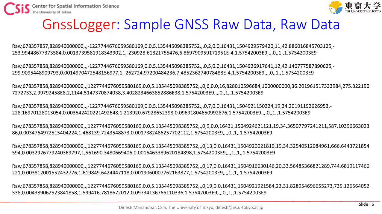
Dinesh Manandhar, CSIS, The University of Tokyo, [email protected] : 6
GnssLogger: Sample GNSS Raw Data, Raw DataRaw,678357857,828940000000,,,-1227744676059580169,0.0,5.135445098385752,,,0,2,0.0,16431,1504929579420,11,42.886016845703125,-253.99448677373584,0.0013739581918343902,1,-230928.61821755476,6.869790959171951E-4,1.57542003E9,,,,0,,1,,1.57542003E9
Raw,678357858,828940000000,,,-1227744676059580169,0.0,5.135445098385752,,,0,5,0.0,16431,1504926917641,12,42.140777587890625,-299.9095448909793,0.0014970472548156977,1,-262724.97200484236,7.485236274078488E-4,1.57542003E9,,,,0,,1,,1.57542003E9
Raw,678357858,828940000000,,,1227744676059580169,0.0,5.135445098385752,,,0,6,0.0,16,828010596684,1000000000,36.201961517333984,275.3221907272733,2.99792458E8,2,1144.5147370874038,3.4028234663852886E38,1.57542003E9,,,,0,,1,,1.57542003E9
Raw,678357858,828940000000,,,-1227744676059580169,0.0,5.135445098385752,,,0,7,0.0,16431,1504921150324,19,34.20191192626953,-228.16970128013054,0.003542420221492648,1,213920.67928652398,0.09691804650992876,1.57542003E9,,,,0,,1,,1.57542003E9
Raw,678357858,828940000000,,,1227744676059580169,0.0,5.135445098385752,,,0,9,0.0,16431,1504924621121,19,34.36507797241211,587.1039666302386,0.0034764972515404224,1,468139.7243548873,0.0017382486257702112,1.57542003E9,,,,0,,1,,1.57542003E9
Raw,678357858,828940000000,,,1227744676059580169,0.0,5.135445098385752,,,0,13,0.0,16431,1504920021810,19,34.32540512084961,666.6443721854594,0.0032926779240369797,1,561690.3480669406,0.0016463389620184898,1.57542003E9,,,,1,,1,,1.57542003E9
Raw,678357858,828940000000,,,1227744676059580169,0.0,5.135445098385752,,,0,17,0.0,16431,1504916630146,20,33.56485366821289,744.6819117466221,0.003812001552432776,1,619849.6424447118,0.0019060007762163877,1.57542003E9,,,,1,,1,,1.57542003E9
Raw,678357858,828940000000,,,1227744676059580169,0.0,5.135445098385752,,,0,19,0.0,16431,1504921921584,23,31.828954696655273,735.126564052538,0.004389062523841858,1,599416.7818672012,0.09734136766110336,1.57542003E9,,,,0,,1,,1.57542003E9
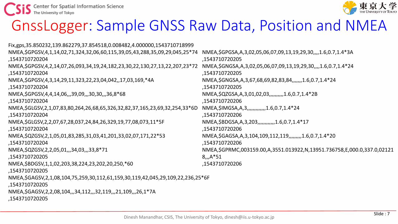
Dinesh Manandhar, CSIS, The University of Tokyo, [email protected] : 7
GnssLogger: Sample GNSS Raw Data, Position and NMEAFix,gps,35.850232,139.862279,37.854518,0.008482,4.000000,1543710718999NMEA,$GPGSV,4,1,14,02,71,324,32,06,60,115,39,05,43,288,35,09,29,045,25*74,1543710720204NMEA,$GPGSV,4,2,14,07,26,093,34,19,24,182,23,30,22,130,27,13,22,207,23*72,1543710720204NMEA,$GPGSV,4,3,14,29,11,323,22,23,04,042,,17,03,169,*4A,1543710720204NMEA,$GPGSV,4,4,14,06,,,39,09,,,30,30,,,36,8*68,1543710720204NMEA,$GLGSV,2,1,07,83,80,264,26,68,65,326,32,82,37,165,23,69,32,254,33*6D,1543710720204NMEA,$GLGSV,2,2,07,67,28,037,24,84,26,329,19,77,08,073,11*5F,1543710720204NMEA,$QZGSV,2,1,05,01,83,285,31,03,41,201,33,02,07,171,22*53,1543710720204NMEA,$QZGSV,2,2,05,01,,,34,03,,,33,8*71,1543710720205NMEA,$BDGSV,1,1,02,203,38,224,23,202,20,250,*60,1543710720205NMEA,$GAGSV,2,1,08,104,75,259,30,112,61,159,30,119,42,045,29,109,22,236,25*6F,1543710720205NMEA,$GAGSV,2,2,08,104,,,34,112,,,32,119,,,21,109,,,26,1*7A,1543710720205
NMEA,$GPGSA,A,3,02,05,06,07,09,13,19,29,30,,,,1.6,0.7,1.4*3A,1543710720205NMEA,$GNGSA,A,3,02,05,06,07,09,13,19,29,30,,,,1.6,0.7,1.4*24,1543710720205NMEA,$GNGSA,A,3,67,68,69,82,83,84,,,,,,,1.6,0.7,1.4*24,1543710720205NMEA,$QZGSA,A,3,01,02,03,,,,,,,,,,1.6,0.7,1.4*2B,1543710720206NMEA,$IMGSA,A,3,,,,,,,,,,,,,1.6,0.7,1.4*24,1543710720206NMEA,$BDGSA,A,3,203,,,,,,,,,,,,1.6,0.7,1.4*17,1543710720206NMEA,$GAGSA,A,3,104,109,112,119,,,,,,,,,1.6,0.7,1.4*20,1543710720206NMEA,$GPRMC,003159.00,A,3551.013922,N,13951.736758,E,000.0,337.0,021218,,,A*51,1543710720206
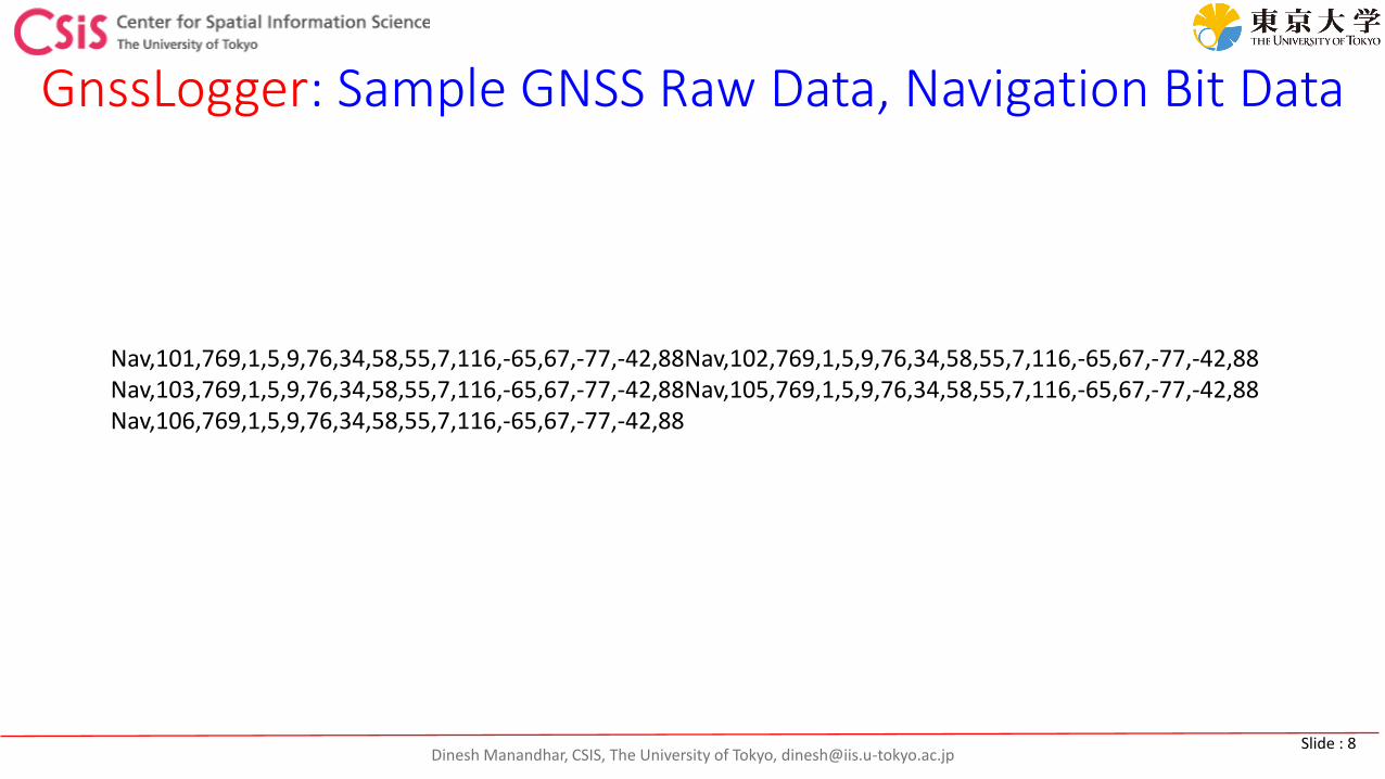
Dinesh Manandhar, CSIS, The University of Tokyo, [email protected] : 8
GnssLogger: Sample GNSS Raw Data, Navigation Bit Data
Nav,101,769,1,5,9,76,34,58,55,7,116,-65,67,-77,-42,88Nav,102,769,1,5,9,76,34,58,55,7,116,-65,67,-77,-42,88Nav,103,769,1,5,9,76,34,58,55,7,116,-65,67,-77,-42,88Nav,105,769,1,5,9,76,34,58,55,7,116,-65,67,-77,-42,88Nav,106,769,1,5,9,76,34,58,55,7,116,-65,67,-77,-42,88

Dinesh Manandhar, CSIS, The University of Tokyo, [email protected] : 9
Android Raw Data Logging APP Geo++ RINEX Logger
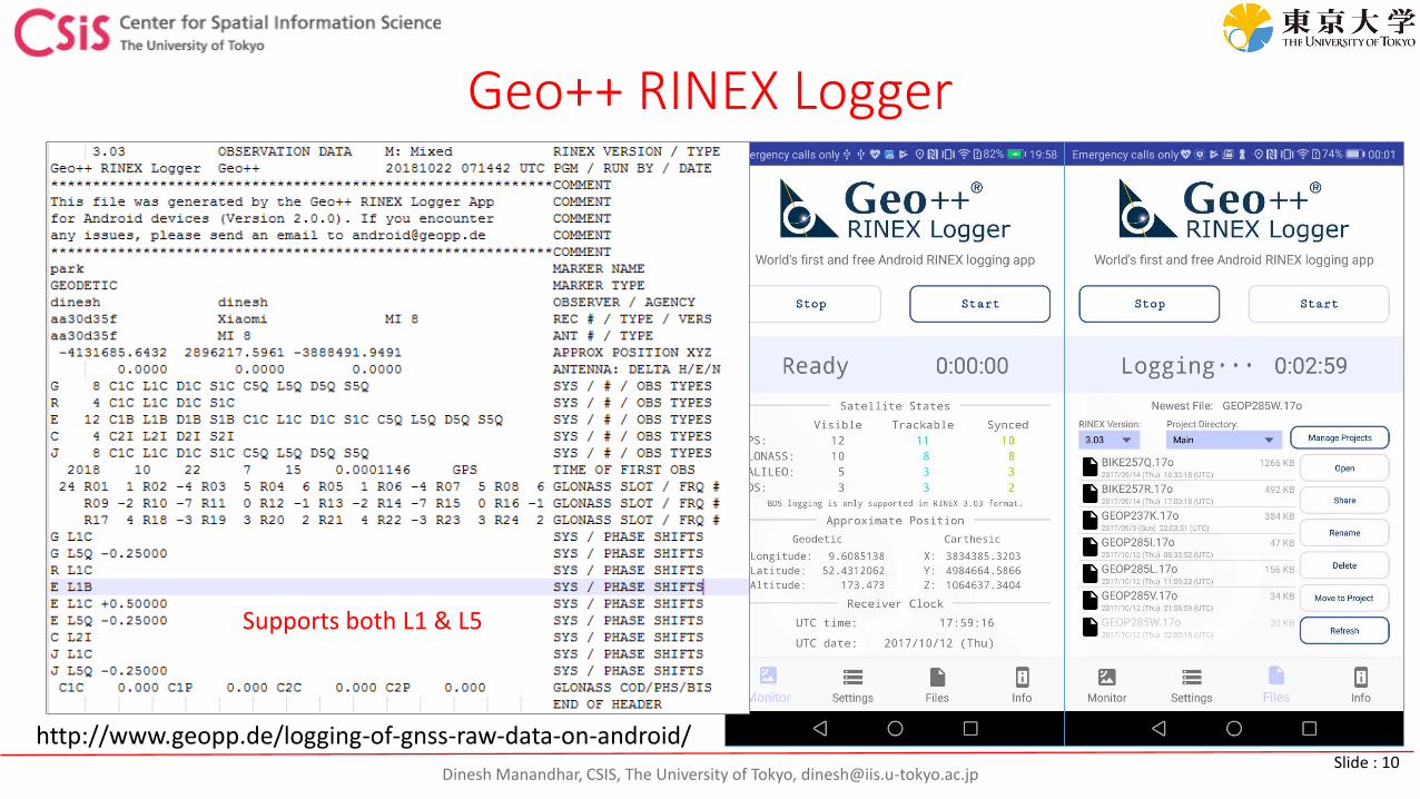
Dinesh Manandhar, CSIS, The University of Tokyo, [email protected] : 10
Geo++ RINEX Logger
http://www.geopp.de/logging-of-gnss-raw-data-on-android/
Supports both L1 & L5
Dinesh Manandhar, CSIS, The University of Tokyo, [email protected] : 11
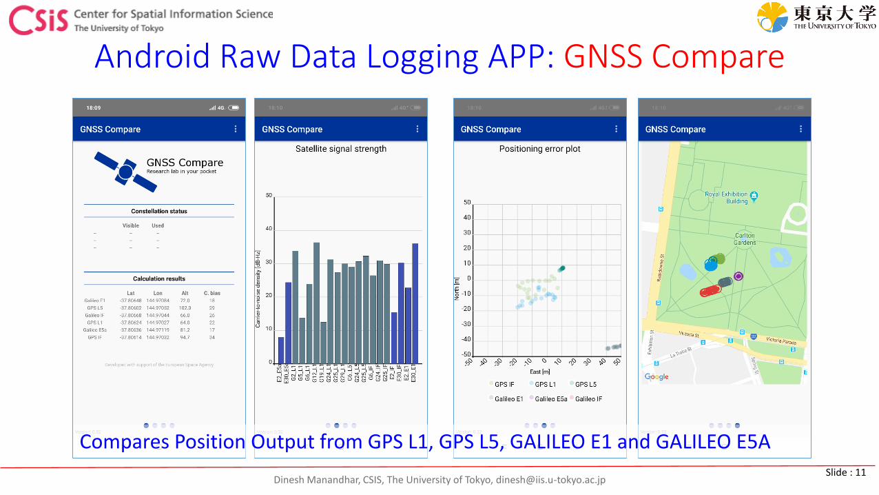
Android Raw Data Logging APP: GNSS Compare
Compares Position Output from GPS L1, GPS L5, GALILEO E1 and GALILEO E5A
Dinesh Manandhar, CSIS, The University of Tokyo, [email protected] : 12
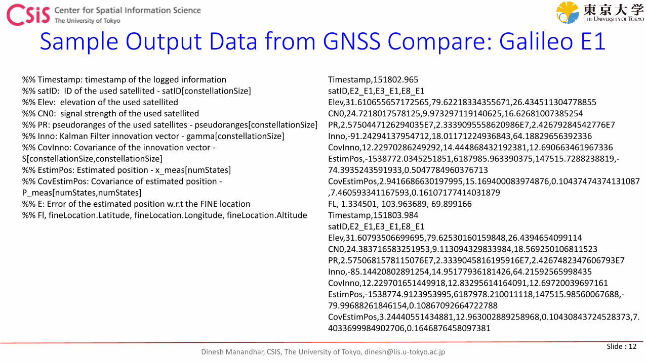
Sample Output Data from GNSS Compare: Galileo E1%% Timestamp: timestamp of the logged information %% satID: ID of the used satellited - satID[constellationSize] %% Elev: elevation of the used satellited %% CN0: signal strength of the used satellited %% PR: pseudoranges of the used satellites - pseudoranges[constellationSize] %% Inno: Kalman Filter innovation vector - gamma[constellationSize] %% CovInno: Covariance of the innovation vector -S[constellationSize,constellationSize] %% EstimPos: Estimated position - x_meas[numStates] %% CovEstimPos: Covariance of estimated position -P_meas[numStates,numStates] %% E: Error of the estimated position w.r.t the FINE location %% Fl, fineLocation.Latitude, fineLocation.Longitude, fineLocation.Altitude
Timestamp,151802.965satID,E2_E1,E3_E1,E8_E1Elev,31.610655657172565,79.62218334355671,26.434511304778855CN0,24.7218017578125,9.973297119140625,16.62681007385254PR,2.5750447126294035E7,2.3339095558620986E7,2.42679284542776E7Inno,-91.24294137954712,18.01171224936843,64.18829656392336CovInno,12.22970286249292,14.444868432192381,12.690663461967336EstimPos,-1538772.0345251851,6187985.963390375,147515.7288238819,-74.3935243591933,0.5047784960376713CovEstimPos,2.9416686630197995,15.169400083974876,0.10437474374131087,7.460593341167593,0.16107177414031879FL, 1.334501, 103.963689, 69.899166Timestamp,151803.984satID,E2_E1,E3_E1,E8_E1Elev,31.60793506699695,79.62530160159848,26.4394654099114CN0,24.383716583251953,9.113094329833984,18.569250106811523PR,2.5750681578115076E7,2.3339045816195916E7,2.4267482347606793E7Inno,-85.14420802891254,14.95177936181426,64.21592565998435CovInno,12.229701651449918,12.83295614164091,12.69720039697161EstimPos,-1538774.9123953995,6187978.210011118,147515.98560067688,-79.99688261846154,0.10867092664722788CovEstimPos,3.24440551434881,12.963002889258968,0.10430843724528373,7.4033699984902706,0.1646876458097381
Dinesh Manandhar, CSIS, The University of Tokyo, [email protected] : 13
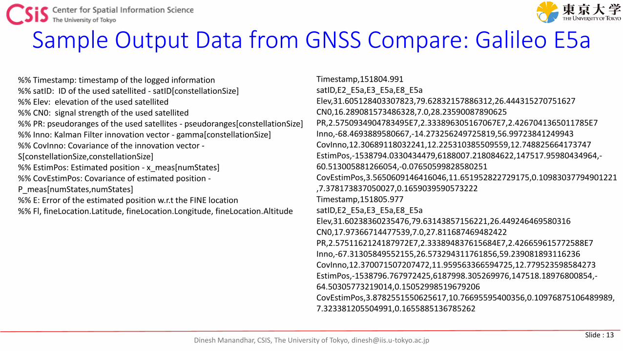
Sample Output Data from GNSS Compare: Galileo E5a
%% Timestamp: timestamp of the logged information %% satID: ID of the used satellited - satID[constellationSize] %% Elev: elevation of the used satellited %% CN0: signal strength of the used satellited %% PR: pseudoranges of the used satellites - pseudoranges[constellationSize] %% Inno: Kalman Filter innovation vector - gamma[constellationSize] %% CovInno: Covariance of the innovation vector -S[constellationSize,constellationSize] %% EstimPos: Estimated position - x_meas[numStates] %% CovEstimPos: Covariance of estimated position -P_meas[numStates,numStates] %% E: Error of the estimated position w.r.t the FINE location %% Fl, fineLocation.Latitude, fineLocation.Longitude, fineLocation.Altitude
Timestamp,151804.991satID,E2_E5a,E3_E5a,E8_E5aElev,31.605128403307823,79.62832157886312,26.444315270751627CN0,16.289081573486328,7.0,28.23590087890625PR,2.5750934904783495E7,2.333896305167067E7,2.4267041365011785E7Inno,-68.4693889580667,-14.273256249725819,56.99723841249943CovInno,12.30689118032241,12.225310385509559,12.748825664173747EstimPos,-1538794.0330434479,6188007.218084622,147517.95980434964,-60.513005881266054,-0.07650599828580251CovEstimPos,3.5650609146416046,11.651952822729175,0.10983037794901221,7.378173837050027,0.1659039590573222Timestamp,151805.977satID,E2_E5a,E3_E5a,E8_E5aElev,31.60238360235476,79.63143857156221,26.449246469580316CN0,17.97366714477539,7.0,27.811687469482422PR,2.5751162124187972E7,2.333894837615684E7,2.426659615772588E7Inno,-67.31305849552155,26.573294311761856,59.239081893116236CovInno,12.370071507207472,11.959563366594725,12.779523598584273EstimPos,-1538796.767972425,6187998.305269976,147518.18976800854,-64.50305773219014,0.15052998519679206CovEstimPos,3.8782551550625617,10.76695595400356,0.10976875106489989,7.323381205504991,0.1655885136785262
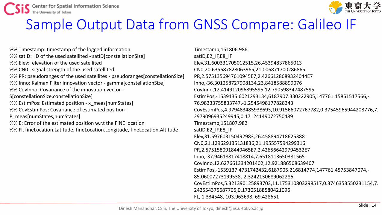
Dinesh Manandhar, CSIS, The University of Tokyo, [email protected] : 14
Sample Output Data from GNSS Compare: Galileo IF
%% Timestamp: timestamp of the logged information %% satID: ID of the used satellited - satID[constellationSize] %% Elev: elevation of the used satellited %% CN0: signal strength of the used satellited %% PR: pseudoranges of the used satellites - pseudoranges[constellationSize] %% Inno: Kalman Filter innovation vector - gamma[constellationSize] %% CovInno: Covariance of the innovation vector -S[constellationSize,constellationSize] %% EstimPos: Estimated position - x_meas[numStates] %% CovEstimPos: Covariance of estimated position -P_meas[numStates,numStates] %% E: Error of the estimated position w.r.t the FINE location %% Fl, fineLocation.Latitude, fineLocation.Longitude, fineLocation.Altitude
Timestamp,151806.986satID,E2_IF,E8_IFElev,31.600331705012515,26.45394837865013CN0,20.635687828063965,21.006871700286865PR,2.5751356947610945E7,2.4266128689324044E7Inno,-36.301258727908134,23.8418588899076CovInno,12.414912096895595,12.790598347487595EstimPos,-1539135.6021293134,6187907.330222905,147761.15851517566,-76.98333755833747,-1.2545498177828343CovEstimPos,4.979483485938693,10.91566072767782,0.37545965944208776,7.2979096935249945,0.17124149072750489Timestamp,151807.982satID,E2_IF,E8_IFElev,31.597603150492983,26.458894718625388CN0,21.129629135131836,21.195557594299316PR,2.5751580918449465E7,2.426566429794532E7Inno,-37.94618817418814,7.6518113650381565CovInno,12.627661334201402,12.921886508639407EstimPos,-1539137.4731742432,6187905.216814774,147761.45753847074,-85.06007273199538,-2.3242130689062286CovEstimPos,5.321390125893703,11.175310803298517,0.3746353550231154,7.242554375687705,0.17305188580421096FL, 1.334548, 103.963698, 69.428651
Dinesh Manandhar, CSIS, The University of Tokyo, [email protected] : 15
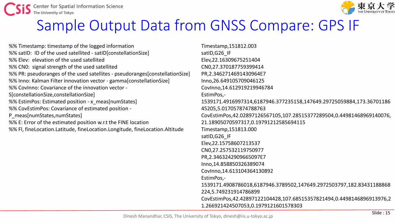
Sample Output Data from GNSS Compare: GPS IF%% Timestamp: timestamp of the logged information %% satID: ID of the used satellited - satID[constellationSize] %% Elev: elevation of the used satellited %% CN0: signal strength of the used satellited %% PR: pseudoranges of the used satellites - pseudoranges[constellationSize] %% Inno: Kalman Filter innovation vector - gamma[constellationSize] %% CovInno: Covariance of the innovation vector -S[constellationSize,constellationSize] %% EstimPos: Estimated position - x_meas[numStates] %% CovEstimPos: Covariance of estimated position -P_meas[numStates,numStates] %% E: Error of the estimated position w.r.t the FINE location %% Fl, fineLocation.Latitude, fineLocation.Longitude, fineLocation.Altitude
Timestamp,151812.003satID,G26_IFElev,22.16309675251404CN0,27.370187759399414PR,2.3462714691430964E7Inno,26.649105709046125CovInno,14.612919219946784EstimPos,-1539171.4916997314,6187946.377235158,147649.29725059884,173.3670118645205,5.017057874788763CovEstimPos,42.02897126567105,107.28515377289504,0.44981468969140076,21.18905070597317,0.19791212585694115Timestamp,151813.000satID,G26_IFElev,22.15758607213537CN0,27.257532119750977PR,2.3463242909665097E7Inno,14.858850326389074CovInno,14.613104364130892EstimPos,-1539171.4908786018,6187946.3789502,147649.2972503797,182.83431188868224,5.749231914786899CovEstimPos,42.42897122104428,107.68515357821494,0.4498146896913976,21.266921424507053,0.1979121601578303
Dinesh Manandhar, CSIS, The University of Tokyo, [email protected] : 16
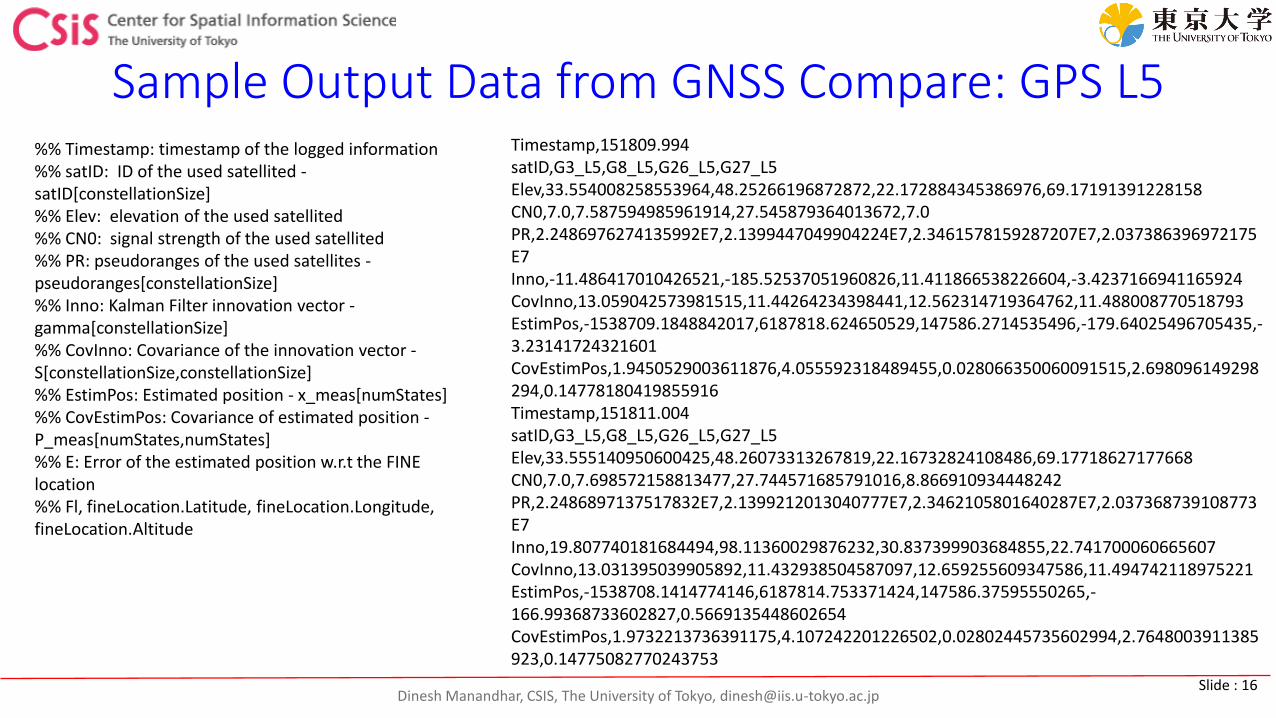
Sample Output Data from GNSS Compare: GPS L5Timestamp,151809.994satID,G3_L5,G8_L5,G26_L5,G27_L5Elev,33.554008258553964,48.25266196872872,22.172884345386976,69.17191391228158CN0,7.0,7.587594985961914,27.545879364013672,7.0PR,2.2486976274135992E7,2.1399447049904224E7,2.3461578159287207E7,2.037386396972175E7Inno,-11.486417010426521,-185.52537051960826,11.411866538226604,-3.4237166941165924CovInno,13.059042573981515,11.44264234398441,12.562314719364762,11.488008770518793EstimPos,-1538709.1848842017,6187818.624650529,147586.2714535496,-179.64025496705435,-3.23141724321601CovEstimPos,1.9450529003611876,4.055592318489455,0.028066350060091515,2.698096149298294,0.14778180419855916Timestamp,151811.004satID,G3_L5,G8_L5,G26_L5,G27_L5Elev,33.555140950600425,48.26073313267819,22.16732824108486,69.17718627177668CN0,7.0,7.698572158813477,27.744571685791016,8.866910934448242PR,2.2486897137517832E7,2.1399212013040777E7,2.3462105801640287E7,2.037368739108773E7Inno,19.807740181684494,98.11360029876232,30.837399903684855,22.741700060665607CovInno,13.031395039905892,11.432938504587097,12.659255609347586,11.494742118975221EstimPos,-1538708.1414774146,6187814.753371424,147586.37595550265,-166.99368733602827,0.5669135448602654CovEstimPos,1.9732213736391175,4.107242201226502,0.02802445735602994,2.7648003911385923,0.14775082770243753
%% Timestamp: timestamp of the logged information %% satID: ID of the used satellited -satID[constellationSize] %% Elev: elevation of the used satellited %% CN0: signal strength of the used satellited %% PR: pseudoranges of the used satellites -pseudoranges[constellationSize] %% Inno: Kalman Filter innovation vector -gamma[constellationSize] %% CovInno: Covariance of the innovation vector -S[constellationSize,constellationSize] %% EstimPos: Estimated position - x_meas[numStates] %% CovEstimPos: Covariance of estimated position -P_meas[numStates,numStates] %% E: Error of the estimated position w.r.t the FINE location %% Fl, fineLocation.Latitude, fineLocation.Longitude, fineLocation.Altitude
Dinesh Manandhar, CSIS, The University of Tokyo, [email protected] : 17
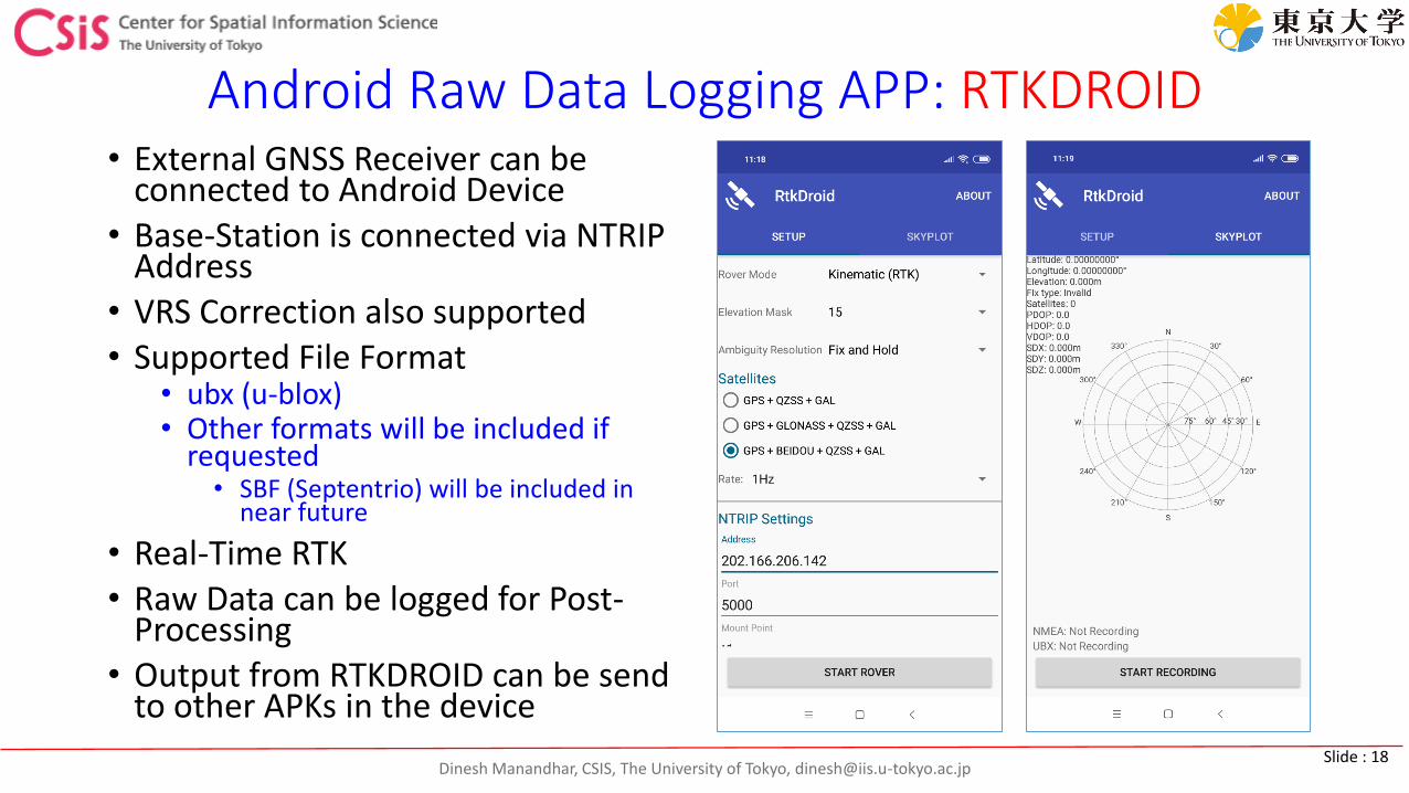
Dinesh Manandhar, CSIS, The University of Tokyo, [email protected] : 18
Android Raw Data Logging APP: RTKDROID• External GNSS Receiver can be
connected to Android Device• Base-Station is connected via NTRIP
Address• VRS Correction also supported • Supported File Format
• ubx (u-blox)• Other formats will be included if
requested• SBF (Septentrio) will be included in
near future
• Real-Time RTK• Raw Data can be logged for Post-
Processing• Output from RTKDROID can be send
to other APKs in the device
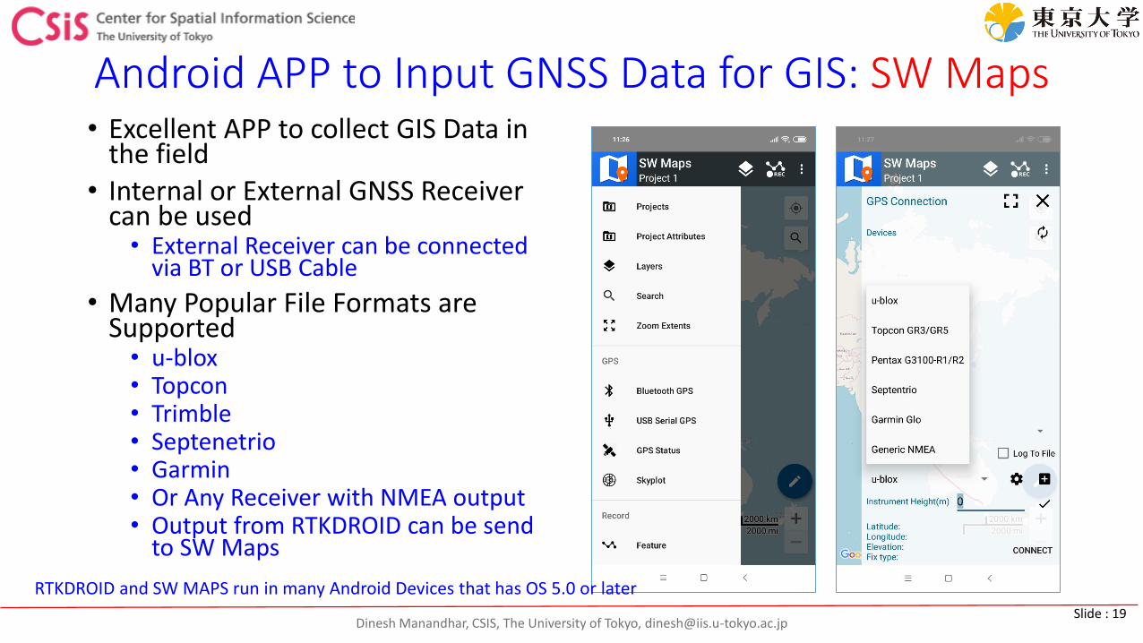
Dinesh Manandhar, CSIS, The University of Tokyo, [email protected] : 19
Android APP to Input GNSS Data for GIS: SW Maps• Excellent APP to collect GIS Data in
the field• Internal or External GNSS Receiver
can be used• External Receiver can be connected
via BT or USB Cable
• Many Popular File Formats are Supported• u-blox• Topcon• Trimble• Septenetrio• Garmin• Or Any Receiver with NMEA output• Output from RTKDROID can be send
to SW Maps
RTKDROID and SW MAPS run in many Android Devices that has OS 5.0 or later
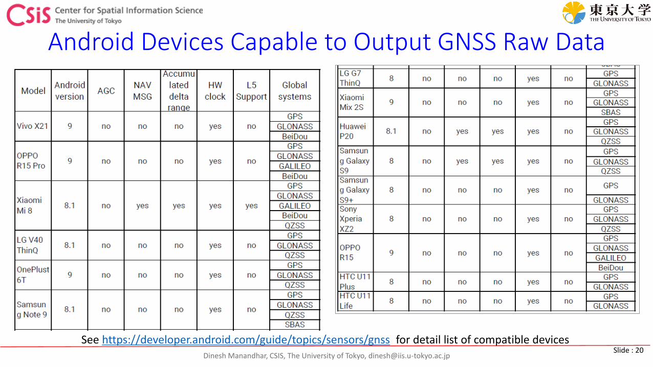
Dinesh Manandhar, CSIS, The University of Tokyo, [email protected] : 20
Android Devices Capable to Output GNSS Raw Data
See https://developer.android.com/guide/topics/sensors/gnss for detail list of compatible devices
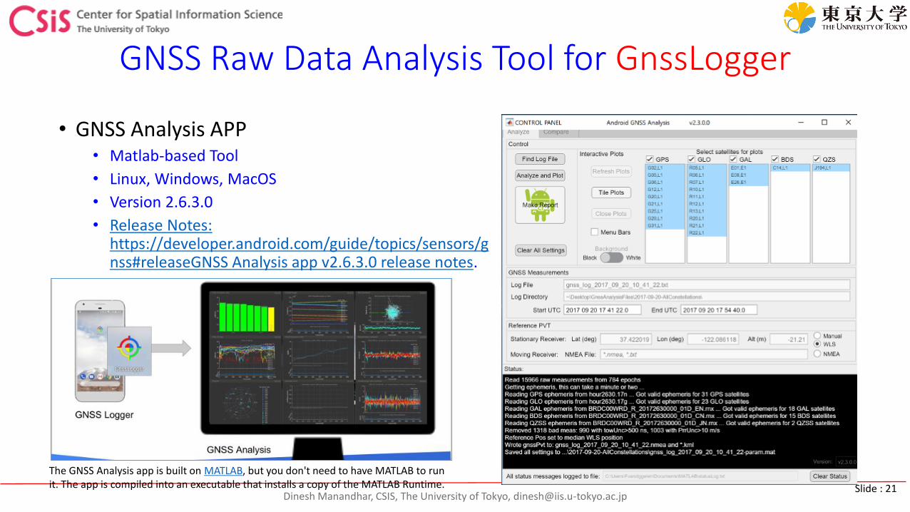
Dinesh Manandhar, CSIS, The University of Tokyo, [email protected] : 21
GNSS Raw Data Analysis Tool for GnssLogger
• GNSS Analysis APP • Matlab-based Tool
• Linux, Windows, MacOS
• Version 2.6.3.0
• Release Notes: https://developer.android.com/guide/topics/sensors/gnss#releaseGNSS Analysis app v2.6.3.0 release notes.
The GNSS Analysis app is built on MATLAB, but you don't need to have MATLAB to run it. The app is compiled into an executable that installs a copy of the MATLAB Runtime.
Dinesh Manandhar, CSIS, The University of Tokyo, [email protected] : 22
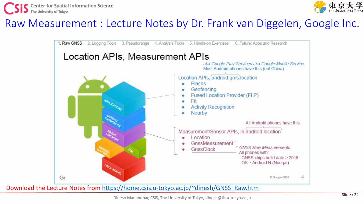
Raw Measurement : Lecture Notes by Dr. Frank van Diggelen, Google Inc.
Download the Lecture Notes from https://home.csis.u-tokyo.ac.jp/~dinesh/GNSS_Raw.htm

Dinesh Manandhar, CSIS, The University of Tokyo, [email protected] : 23
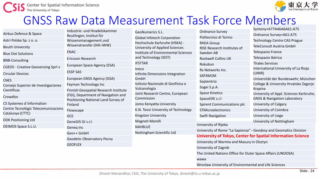
GNSS Raw Data Measurement Task Force Members
https://www.gsa.europa.eu/gnss-raw-measurements-task-force
CSIS, The University of Tokyo is also a Member of the Task Force
Dinesh Manandhar, CSIS, The University of Tokyo, [email protected] : 24
University of Rijeka
University of Rome "La Sapienza" - Geodesy and Geomatics Division
University of Tokyo, Center for Spatial Information Science
University of Warmia and Mazury in Olsztyn
University of Zagreb
The United Nations Office for Outer Space Affairs (UNOOSA)
wawa
Wrocław University of Environmental and Life Sciences
Syntony+A77A46A6A61:A75
Ordnance Survey+A61:A75
Technology Centre CAS Prague
TeleConsult Austria GmbH
Telespazio France
Telespazio Ibérica
Thales Services
International University of La Rioja (UNIR)
Universität der Bundeswehr, München
College & University Hrvatsko Zagorje Krapina
University of Appl. Sciences Karlsruhe, GNSS & Navigation Laboratory
University of Calgary
University of Coimbra
University of Liege
University of Nottingham
GNSS Raw Data Measurement Task Force MembersAirbus Defence & Space
Astri Polska Sp. z o. o.
Beuth University
Blue Dot Solutions
BNB-Consulting
CGEOS - Creative Geosensing Sprl-s
Circular Devices
CNES
Consejo Superior de Investigaciones Científicas
Crowdloc
CS Systemes d`Information
Centre Tecnològic TelecomunicacionsCatalunya (CTTC)
DDK Positioning Ltd
DEIMOS Space S.L.U.
Industrie- und Hnadelskammer Reutlingen, Institut für Wissensmanagement und Wissenstransfer (IHK-IWW)
ENAC
Ericsson Research
European Space Agency (ESA)
ESSP SAS
European GNSS Agency (GSA)
Feyman Technology Inc
Finnish Geospatial Research Institute (FGI), Department of Navigation and Positioning National Land Survey of Finland
Flowscape
GCE
GeneGIS GI s.r.l.
Geneq Inc
Geo++ GmbH
Geodetic Observatory Pecny
GEOFLEX
GeoNumerics S.L.
Global Infotech Corporation
Hochschule Karlsruhe (HSKA) -University of Applied Sciences
Institute of Environmental Sciences and Technology (IEST)
IFSTTAR
Ineco
Infinite Dimensions Integration GmbH
Istituto Nazionale di Geofisica e Vulcanologia
Joint Research Centre, European Commission
Jomo Kenyatta University
K.N. Toosi University of Technology
Kingston University
Magneti Marelli
NAVBLUE
Nottingham Scientific Ltd
Ordnance Survey
Politecnico di Torino
RHEA Group
RISE Research Institutes of Sweden AB
Rockwell Collins UK
Rokubun
Rx Networks Inc.
SAT4M2M
Septentrio
Sogei S.p.A.
Space Kinetics
SpaceEXE s.r.l
Spirent Communications plc
STMicroelectronics
Swift Navigation
Dinesh Manandhar, CSIS, The University of Tokyo, [email protected] : 25
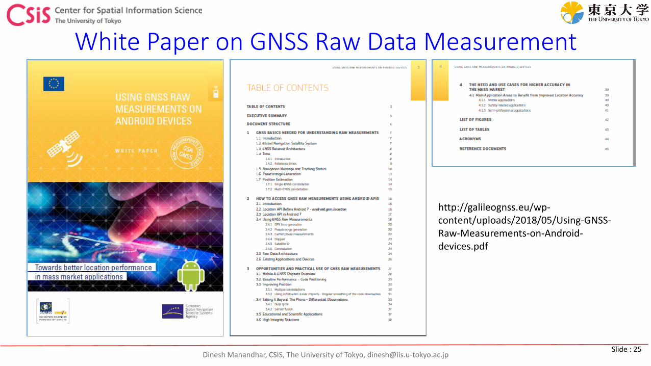
White Paper on GNSS Raw Data Measurement
http://galileognss.eu/wp-content/uploads/2018/05/Using-GNSS-Raw-Measurements-on-Android-devices.pdf
Dinesh Manandhar, CSIS, The University of Tokyo, [email protected] : 26
GNSS Raw Data Measurement from Android Devices
Tutorial Note by Dr. Frank, Google Inc.
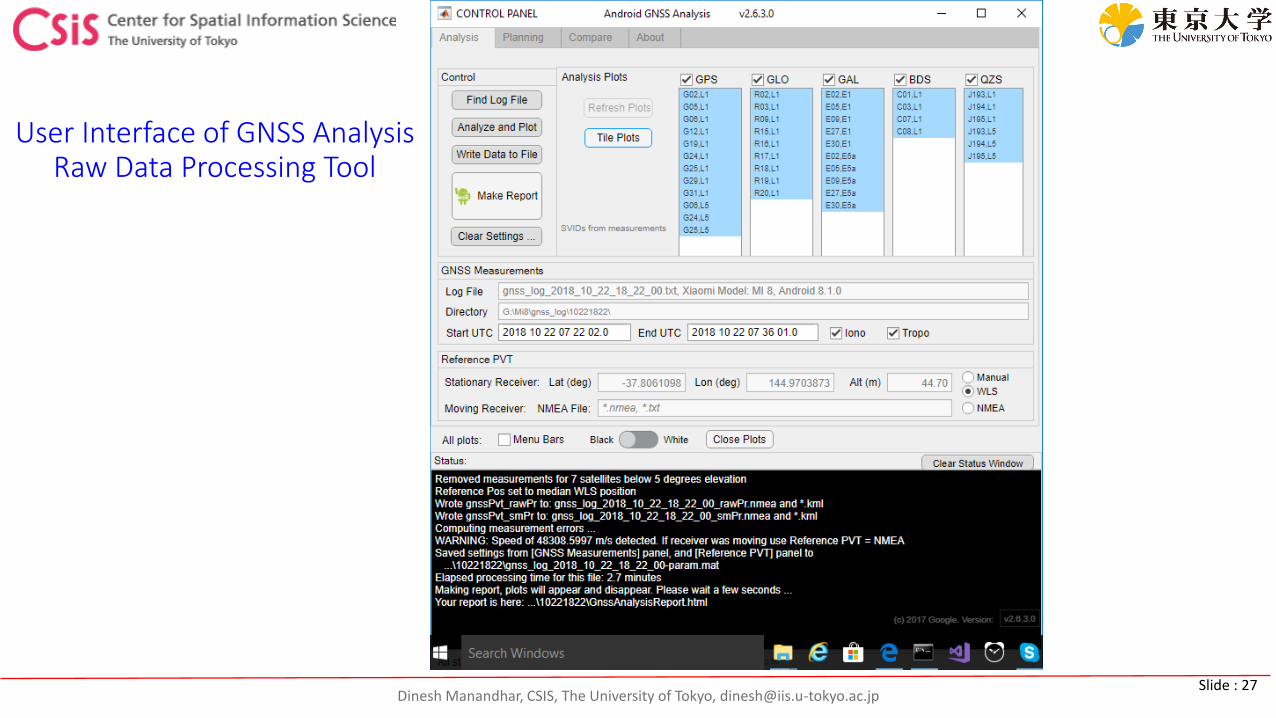
Dinesh Manandhar, CSIS, The University of Tokyo, [email protected] : 27
User Interface of GNSS Analysis Raw Data Processing Tool
Dinesh Manandhar, CSIS, The University of Tokyo, [email protected] : 28
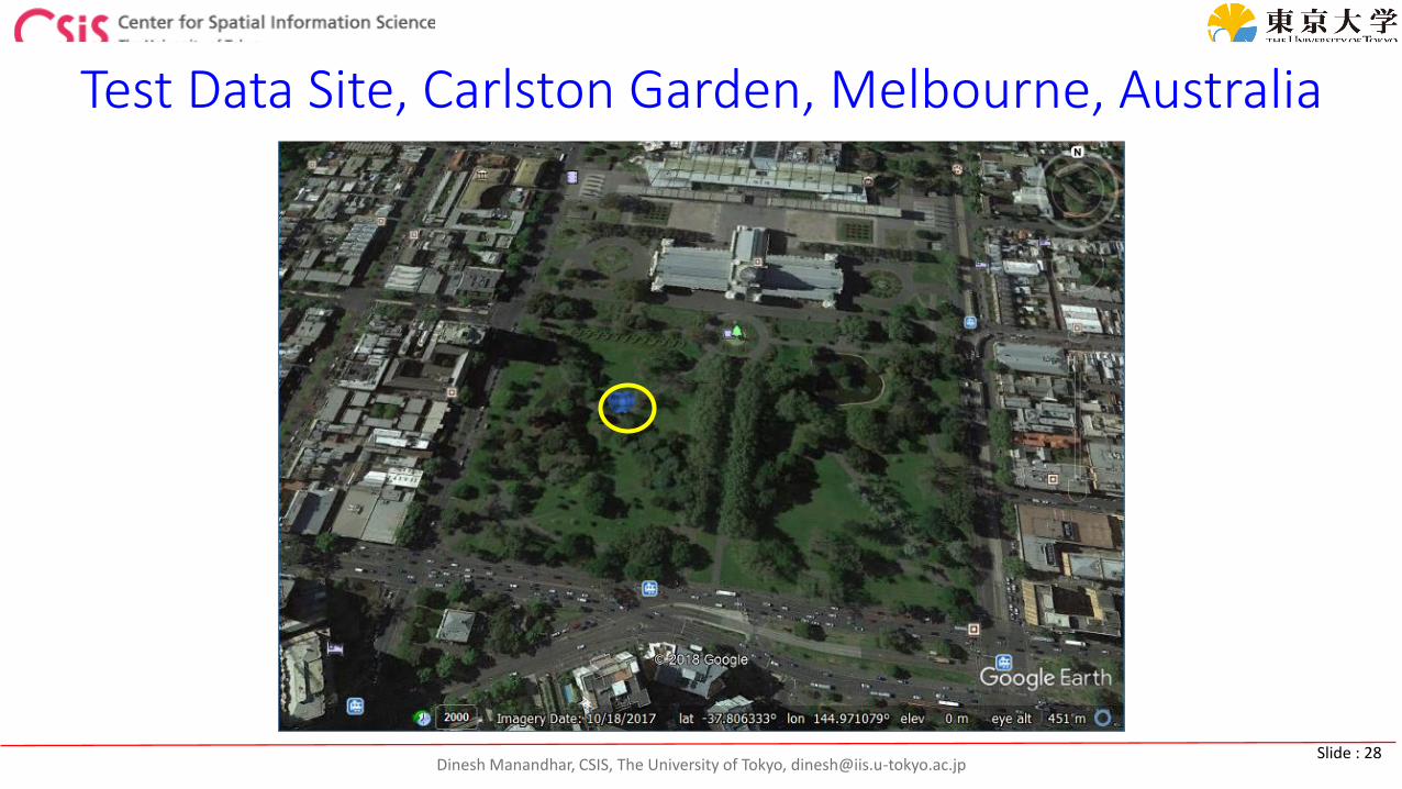
Test Data Site, Carlston Garden, Melbourne, Australia
Dinesh Manandhar, CSIS, The University of Tokyo, [email protected] : 29
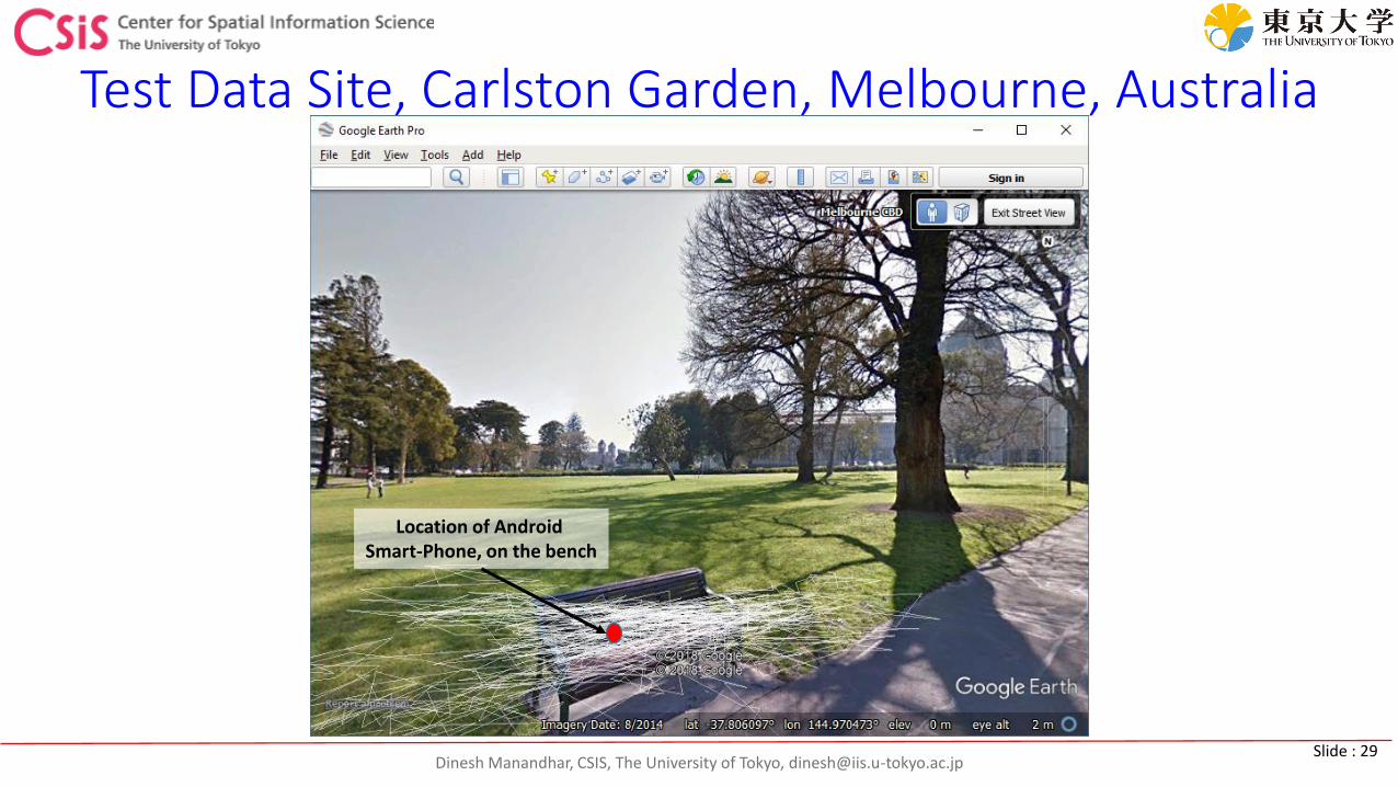
Test Data Site, Carlston Garden, Melbourne, Australia
Location of Android Smart-Phone, on the bench
Dinesh Manandhar, CSIS, The University of Tokyo, [email protected] : 30