Embed Size (px)
Citation preview
REGIONAL TOWN CENTRE
Community Plan Information
MetrotownGeneral Land Use Map
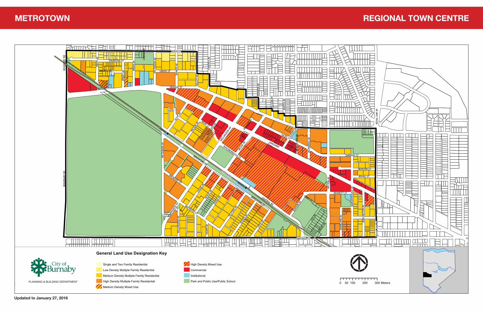
GENERAL LAND USE MAP – Updated to January 27, 2016
The general land use designations depicted on this map are based on the Metrotown Community Plan including all plan amendments and rezoning approvals adopted by Council. Site specific land uses, development guidelines, desired assemblies and road dedications are further defined by the Community Plan, Burnaby Zoning Bylaw, Comprehensive Development Plans and other City plans, policies, guidelines and bylaws.
DISCLAIMER OF USE:
City of Burnaby Community Plans and general land use maps are provided as a public service. Community Plans are adopted by Council as a policy guideline for consideration of specific rezoning development applications. Community Plans and general land use designations are subject to change and amendment by Council.
Users of this information should verify all property and zoning information with written confirmation from the Burnaby Planning and Building Department. The City of Burnaby does not warrant the accuracy of information shown in this General Land Use Map and accepts no responsibility for any damages suffered by any person as a result of decisions made, or actions based on informational content.
For more Community Plan Information or site specific zoning information, please contact us:
City of BurnabyPlanning and Building Department4949 Canada Way Burnaby, BC V5G 1M2
Telephone: 604-294-7400Fax: 604-294-7220Email: [email protected]
Or visit the Community Plan section on our website: www.burnaby.ca
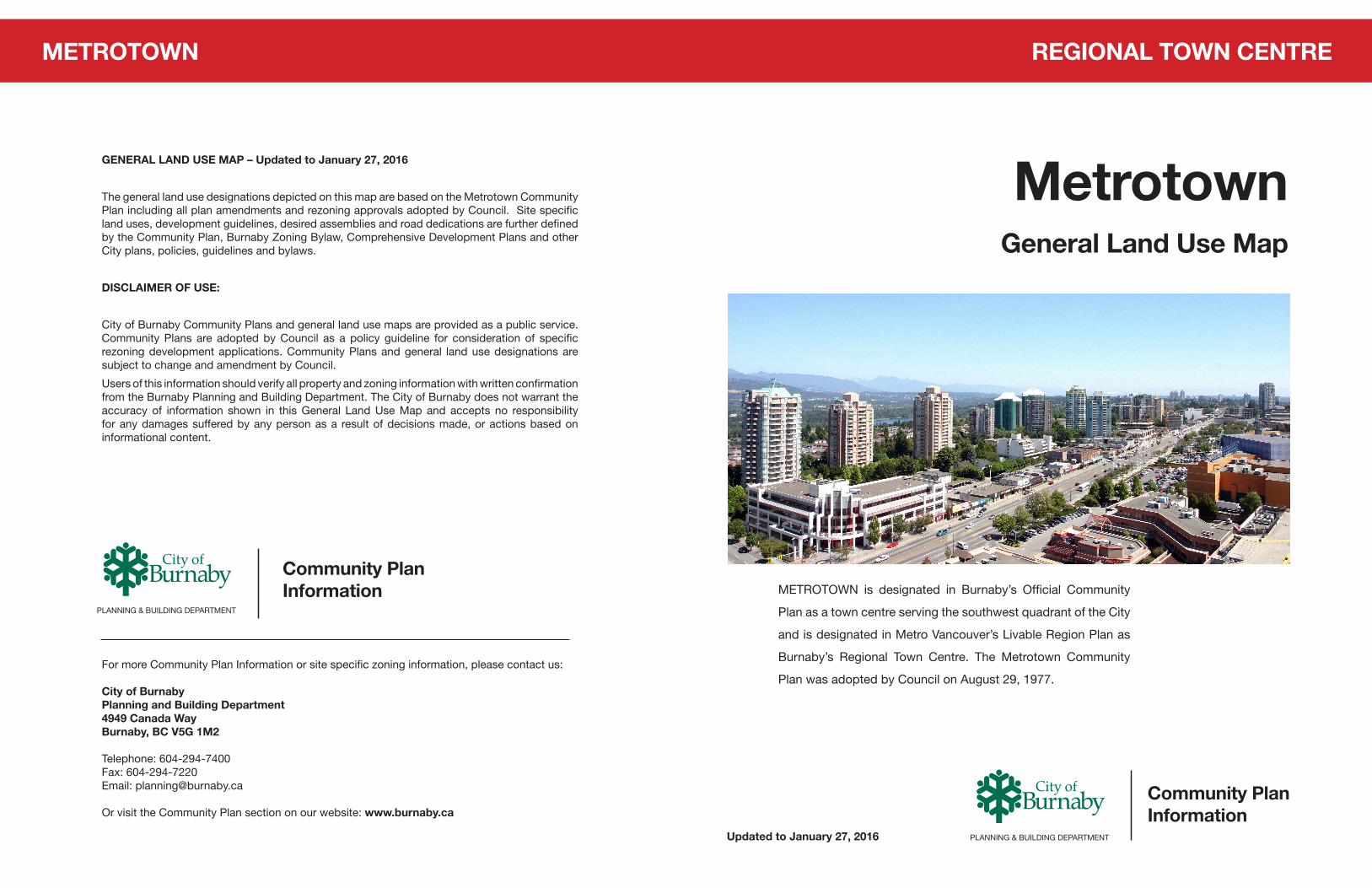
METROTOWN is designated in Burnaby’s Official Community
Plan as a town centre serving the southwest quadrant of the City
and is designated in Metro Vancouver’s Livable Region Plan as
Burnaby’s Regional Town Centre. The Metrotown Community
Plan was adopted by Council on August 29, 1977.
Community Plan Information
PLANNING & BUILDING DEPARTMENT
PLANNING & BUILDING DEPARTMENTUpdated to January 27, 2016
METROTOWN
KINGSWAY
CENTRAL BV
GRANGE ST
BOND ST
NELS
ON
AV
PATT
ERSO
N A
V
HAZEL ST
WIL
SON
AV
MCKA
Y AV
IMPERIAL ST
BERESFORD ST
SMIT
H A
V
MAYWOOD ST
THURSTON ST
SILV
ER A
V
BARK
ER A
V
CASS
IE AV
INM
AN A
V
SUSS
EX A
V
MAR
LBO
ROU
GH
AV
DOW
AV
SARDIS ST
HAL
LEY
AV
OLIV
E AV
NEWTON ST
LILY
AV
SANDERS ST
BENNETT ST
TELF
ORD
AV
KEMP ST
BURL
ING
TON
AV
JERS
EY A
V
BOU
NDA
RY R
D
WIL
LING
DON
EX
BOO
TH A
V
MCM
URR
AY A
V
IRVING STMAYBERRY ST
BONS
OR A
V
JUBI
LEE
AV
SANDELL ST
DUN
BLAN
E AV
KATH
LEEN
AV
ELSO
M A
V
WIL
LIN
GDO
N A
V
CHAF
FEY
AV
MCK
ERCH
ER A
V
KINGSBOROUGH ST
ROYA
L O
AK A
V
BRIEF ST
PIO
NEE
R AV
GRA
Y AV
LIN
DSA
Y AV
BOU
NDA
RY R
D
WIL
LING
DON
AV
PATT
ERSO
N A
V
SUSS
EX A
V
BERESFORD ST
MCKA
Y AV
SILV
ER A
V
ROYA
L O
AK A
V
PION
EER
AV
EXPO LINE
´
Metrotown Plan
0 100 200 30050 Meters
1:9,500
General Land Use Designation Key
Single and Two Family Residential
Low Density Multiple Family Residential (RM1)
Medium Density Multiple Family Residential (RM2/RM3)
High Density Multiple Family Residential (RM4/RM5)
Medium Density Mixed Use (C9 or RM3/C2)
High Density Mixed Use (RM5/C3 or RM5/C2)
Commercial (C2/C3)
Institutional (P1/P2/P5)
Park and Public Use/Public School (P3)
Patterson
Metrotown
T:\GIS\projects\development plans\maps\Metrotown.pdf - Updated to January 27, 2016
PLANNING & BUILDING DEPARTMENT
REGIONAL TOWN CENTREMETROTOWN
Updated to January 27, 2016
PLANNING & BUILDING DEPARTMENT