Embed Size (px)
Citation preview

Metro East Joint Development Assessment Panel Agenda
Meeting Date and Time: 11 September 2018; 10am Meeting Number: MEJDAP/171 Meeting Venue: Shire of Serpentine Jarrahdale 6 Paterson Street Mundijong Attendance
DAP Members Mr Ian Birch (Presiding Member) Ms Kym Petani (Deputy Presiding Member) Mr Peter McNab (Specialist Member) Cr Michelle Rich (Local Government Member, Shire of Serpentine Jarrahdale) Cr Keira McConkey (Local Government Member, Shire of Serpentine Jarrahdale) Officers in attendance Mr Ashwin Nair (Shire of Serpentine Jarrahdale) Minute Secretary Ms Wendy Joy (Shire of Serpentine Jarrahdale) Applicants and Submitters Mr Alessandro Stagno (Planning Solutions) Mr Ben Doyle (Planning Solutions) Mr Vladimir Baltic (Transore) Mr Dennis Delaney (Caltex) Ms Linda Rowley (Rowley Legal) Mr Sam Laybutt (Cardno) Mr George Hajigabriel (Rowe Group) Members of the Public / Media Nil 1. Declaration of Opening
The Presiding Member declares the meeting open and acknowledges the past and present traditional owners and custodians of the land on which the meeting is being held.
2. Apologies
Nil
Version: 6 Page 1

3. Members on Leave of Absence
Nil.
4. Noting of Minutes
Signed minutes of previous meetings are available on the DAP website.
5. Declarations of Due Consideration
Any member who is not familiar with the substance of any report or other information provided for consideration at the DAP meeting must declare that fact before the meeting considers the matter.
6. Disclosure of Interests
Member Item Nature of Interest Ms Kym Petani 8.1 Impartiality Interest –
Ms Petani is an employee and shareholder of GHD. GHD are currently engaged by the Shire of Serpentine Jarrahdale to undertake an intersection design for Abernethy and San Simeon Roads and a roundabout design for Kargotic and Abernethy Roads. GHD have also previously been engaged by DPLH to undertake a road planning design for Rowley and Anketell/Thomas Roads to provide road reserve definitions between Tonkin Highway and Kwinana Freeway.
7. Deputations and Presentations
7.1 Mr George Hajigabriel (Rowe Group) presenting against the application
at Item 8.1. The presentation will address the planning objections in relation to the access arrangements to Thomas Road.
7.2 Mr Sam Laybutt (Cardno on behalf of Humich Nominees Pty Ltd)
presenting against the application at Item 8.1. The presentation will address the proposed access arrangements to Thomas Road.
7.3 Ms Linda Rowley (Rowley Legal) presenting against the application at
Item 8.1. The presentation will address orderly and proper planning principles in respect of the access proposed to Thomas Road from this development.
7.4 Mr Alessandro Stagno (Planning Solutions) presenting in support of the
application at Item 8.1. The presentation will support the RAR recommendation but request a number of modifications to the conditions.
7.5 Mr Vladimir Baltic (Transcore) presenting in support of the application at
Item 8.1. The presentation will support the RAR and will address the proposed access arrangements.
Version: 6 Page 2

7.6 Mr Ben Doyle (Planning Solutions) presenting in support of the application at Item 8.1. The presentation will support the proposed development and the Shires recommendation for approval.
The Shire of Serpentine Jarrahdale may be provided with the opportunity to respond to questions of the panel, as invited by the Presiding Member.
8. Form 1 – Responsible Authority Reports – DAP Applications
8.1 Property Location: Lot 12, 1537 Thomas Road and Lot 50
Nicholson Road, Oakford Development Description: ‘Service Station’ Applicant: Planning Solutions Owner: SL McMullen and DA Riley (Lot 12)
S and J Piipponen (Lot 50) Responsible Authority: Shire of Serpentine Jarrahdale DAP File No: DAP/18/01394
9. Form 2 – Responsible Authority Reports – Amending or cancelling DAP
development approval
Nil
10. Appeals to the State Administrative Tribunal
Current Applications LG Name Property Location Application Description City of Swan Lot 357 (227) Morrison
Road, Midvale Neighbourhood Centre (Shop, Consulting Rooms, Recreation – Private, Fast Food Outlet, Convenience Store)
City of Swan Lot 42 Old West Road, Bullsbrook
Proposed Roadhouse
Shire of Serpentine Jarrahdale
Lots 30 (801) and 31 (803) South Western Highway, Byford
Service Centre and Associated Food and Beverage and Commercial Tenancies
City of Gosnells
7 (Lot 10) Kelvin Road, 1910 (Lot 6) & 1914 (Lot 12) Albany Highway Maddington
Motor Vehicle Sales and Motor Vehicle Repair
City of Kalamunda
Lot 7 (24) Valencia Road, Carmel
Expansion of Valencia Nursing Home with Additional Beds and Associated Facilities
City of Swan Lot 100 (3301) West Swan Road, Caversham
Proposed Roadhouse, Restaurant/Tavern and Tourist Facilities (short stay accommodation)
City of Swan Lots 11 (6791) and 22 (6841) West Swan Road, West Swan
Proposed Restaurant Development
Version: 6 Page 3

Current Applications LG Name Property Location Application Description City of Swan Lots 76 and 202 (398)
Bushmead Road, Lot 4 (286) Stirling Crescent and Lot 800 (107) Lakes Road,
Industry Additions (Asphalt Plants)
11. General Business / Meeting Closure
In accordance with Section 7.3 of the DAP Standing Orders 2017 only the Presiding Member may publicly comment on the operations or determinations of a DAP and other DAP members should not be approached to make comment.
Version: 6 Page 4

Form 1 - Responsible Authority Report (Regulation 12)
Property Location: Lot 12, 1537 Thomas Road and Lot 50 Nicholson Road, Oakford
Development Description: ‘Service Station’ DAP Name: Metro East Joint Development Assessment
Panel Applicant: Planning Solutions Owner: SL McMullen and DA Riley (Lot 12)
S and J Piipponen (Lot 50) Value of Development: $3 Million LG Reference: PA18/193 Responsible Authority: Shire of Serpentine Jarrahdale Authorising Officer: Ashwin Nair – Manager Statutory Planning
and Compliance DAP File No: DAP/18/01394 Report Due Date: 20 June 2018 Application Received Date: 28 March 2018 Application Process Days: 90 Days Attachment(s): 1. Application details
2. Summary of Submissions 3. Photomontages 4. Council Minutes
Officer Recommendation: That the Metro East JDAP resolves to: Approve DAP Application reference DAP/18/01394 and accompanying plans (Attachment 1) in accordance with Clause 68 of the Planning and Development (Local Planning Schemes) Regulations 2015 and the provisions of the Shire of Serpentine Jarrahdale Town Planning Scheme No. 2 subject to the following conditions:- 1. The development is to be carried out in compliance with the plans and
documentation listed below and endorsed with the Shire of Serpentine Jarrahdale stamp, except where amended by other conditions of this consent.
Plans and Specifications P1 – P22 received at the Shire Offices on
28 March 2018 and 24 July 2018 and Bushfire Management Plan and Risk Management Plans dated 19 March 2018
2. Prior to commencement of works, a landscaping/revegetation plan shall be
submitted to and approved by the Shire of Serpentine Jarrahdale. Within 60 days of commencement, the approved landscaping/revegetation plan shall be implemented and maintained thereafter.
Page 1

3. Prior to commencement of works, a detailed Stormwater Plan shall be submitted to and approved by the Shire of Serpentine Jarrahdale. The approved Stormwater Plan shall be implemented and maintained thereafter.
4. Prior to the commencement of works, a Construction Management Plan shall be
submitted to and approved by the Shire of Serpentine Jarrahdale. The Construction Management Plan shall include but not be limited to the following information:-
• Dust management • Traffic management
These approved plans shall be implemented and maintained throughout the construction of the development.
5. Prior to occupation, a lighting plan shall be submitted to and approved by the
Shire of Serpentine Jarrahdale. The approved lighting plan shall be implemented and maintained thereafter.
6. Prior to occupation, an agreed monetary contribution shall be paid to the
Shire of Serpentine Jarrahdale for the establishment of public art in accordance with Council's Local Planning Policy 1.6 - Public Art to the satisfaction of the Shire of Serpentine Jarrahdale.
7. The pylon sign shall be no higher than 7m unless otherwise approved by the
Shire of Serpentine Jarrahdale.
8. Prior to Commencement of works, a Noise Assessment and Management Plan shall be submitted to and approved by the Shire of Serpentine Jarrahdale. Once approved, the plans shall be implemented and maintained thereafter.
9. The service station is not to be operational before the Main Roads Roundabout is constructed.
Main Roads Nicholson Road Access 10. One 11 metre wide crossover located within Lot 50 and positioned where
possible near the northernmost cadastral boundary of Lot 50. This requirement is to protect the functional area of this intersection in accordance with Austroads 2017 Guide to Road Design Part 4 Intersections and Crossings General, section 7 .2 Property Access. This access shall operate as left in/left out turning movements for light vehicles and left out only turning movements for heavy vehicles and shall have suitable signage advising motorists of these restricted movements. The developer shall be responsible for all costs involved in the land acquisition, design and construction of the left turning pocket and solid median to prevent right out turning movements onto Nicholson Road. This includes signing, road markings, relocation of services, street lighting and
Page 2

Main Roads costs involved in the checking of the design and construction drawings and any site inspections Thomas Road
11. One 11 metre wide crossover located within Lot 12 and positioned where
possible near the easternmost cadastral boundary of Lot 12. This requirement is to protect the functional area of this intersection in accordance with Austroads 2017 Guide to Road Design Part 4 Intersections and Crossings General, section 7.2 Property Access.
This access shall operate as left in/left out turning movements for light vehicles and left in only turning movements for heavy vehicles and shall have suitable signage advising motorists of these restricted movements.
The developer shall be responsible for all costs involved in the land acquisition, design and construction of the left turning pocket and solid median to prevent right out movements onto Thomas Road. This includes signing, road markings, relocation of services, street lighting and Main Roads costs involved in the checking of the design and construction drawings and any site inspections
12. Any services, infrastructure or roadside furniture that requires relocation as a
result of the applicant's works will be at the applicant's cost.
13. Lot 50 is affected by land reserved in the Metropolitan Region Scheme for "Other Regional Road" and no development will be permitted within this land required for road purposes at some time in the future. The applicant is advised to contact the Department Planning, Lands & Heritage - Infrastructure Land Use Co-Ordinating Branch (ILUC) for further details in this regard.
14. No earthworks shall encroach onto the Nicholson and Thomas Road road reserve.
14. No stormwater drainage shall be discharged onto the Nicholson and Thomas Road road reserve.
15. The applicant shall make good any damage to the existing verge vegetation
within the Nicholson and Thomas Road road reserve. 16 The applicant must obtain approval from Main Roads before all works are
undertaken within the Thomas Road reserve. The applicant seeking access to the Main Roads network will be required to submit an Application as outlined in the "Application Kit and Guidelines" for State Roads.
Application Kits can be found on the Main Roads website >"Our Roads" >"Conducting Works on Roads >"Applications to Undertake Works on State Roads" >Application Kit and Guidelines for Complex Works OR Application Form for Low Complexity Works.
Page 3

Advertising Signage 17. The type of sign, size, content and location must comply with all relevant by-
laws and planning schemes made by Council. 18. The sign and sign structure is to be placed on private property and shall not
over hang or encroach upon the road reserve. 19. As the signage is illuminated, it must be of a low-level not exceeding
300cdi"'2, not flash, pulsate or chase 20. The device shall not contain fluorescent, reflective or retro reflective colours
or materials. 21. No other unauthorized signing is to be displayed 22. Main Roads agreement is to be obtained prior to any future modifications. 23. Vegetation within the state road reserve shall not be removed or trimmed to
improve the visibility of the proposed advertising sign. Advice Notes
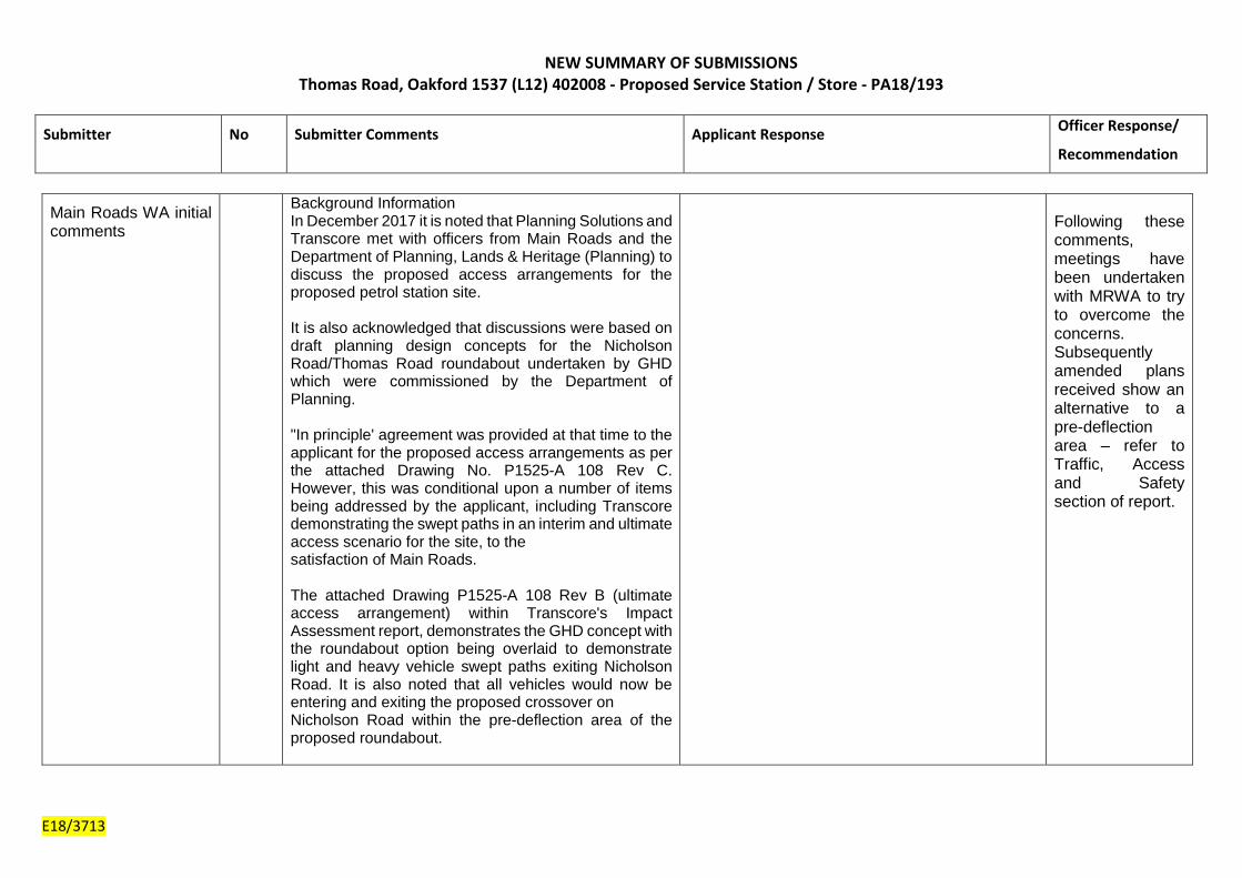
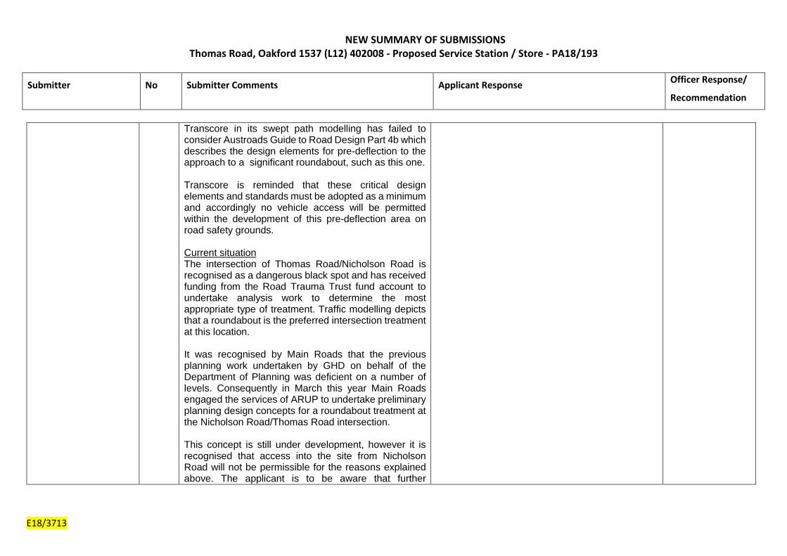
1. As you are aware, this intersection is recognised as a dangerous black spot and has received funding from the Road Trauma Fund account to undertake preliminary planning design concepts. At this point in time, the traffic modelling depicts that the preferred intersection treatment at this location is a roundabout treatment, for both interim and ultimate stage.
The applicant is reminded that upon the roundabout being constructed to its ultimate configuration, the existing access on Nicholson Road will be removed and all access into the petrol station development will be achieved via a dedicated service road accessed from the north of Lot 50.
Please be aware that the timing of the construction of the roundabout {both interim and ultimate stages) including the preferred type of intersection treatment for this intersection is subject to change and that Main Roads assumes no liability whatsoever for the information provided.
2. An internal 15% design review has been undertaken for the submitted
drawings for this development proposal. The attached design review comments are not to be considered a comprehensive design verification and may not pick-up all the issues. Therefore it is not an approval of the presented design.
Page 4

Details: outline of development application Insert Zoning MRS: ‘Rural’ TPS: ‘Rural’ Insert Use Class: ‘Service Station’ Insert Strategy Policy: Rural Strategy Review 2013 Insert Development Scheme: Shire of Serpentine Jarrahdale Town Planning
Scheme No.2 Insert Lot Size: Lot 12 – 1.36ha, Lot 50 – 1.4ha Insert Existing Land Use: Dog Training Facility (‘Use Not Listed’) The application seeks approval for a ‘Service Station’ that would operate 24 hours a day, 7 days a week. Full details of the proposal are contained within Attachment 1. The proposal comprises of the following:-
• Retail building 220m2; • Four light vehicle fuel bowsers with eight refuelling bays; • Three heavy vehicle fuel bowsers with two refuelling bays; • An enclosed plant yard; • One left in/left out crossover to Thomas Road; • One left in/left out crossover to Nicolson Road; • Eleven standard car parking bays; • Three caravan parking bays; • Three truck parking bays; • Landscaping; and • Signage.
Due to the future upgrading of Thomas Road and the provision of a roundabout at the intersection, the applicant has provided interim and ultimate access arrangements. The ultimate access arrangements provide concept plans taking into account the future works to the roads and intersection. Although the final design drawings have not yet been finalised, it is known that a roundabout is to be provided at the intersection and therefore the applicant has demonstrated how the proposal would potentially work once this has occurred. The proposal is considered a ‘Service Station’ land use, defined under the Shire’s Town Planning Scheme No. 2 (TPS2) as:-
“land and buildings used for the supply of petroleum products and motor vehicle accessories and for carrying out greasing, tyre repairs and minor mechanical repairs and may include a cafeteria, restaurant or shop incidental to the primary use; but does not include transport depot, panel beating, spray painting, major repairs or wrecking”;
The subject site is zoned ‘Rural’ under TPS2 where a ‘Service Station’ is an ‘SA’ land use which means that “the Council may, at its discretion, permit the use after notice of the application has been given in accordance with Clause 64 of the Deemed Provisions”. The report recommends that the application is approved subject to conditions from both Shire Officers and Main Roads Western Australia (MRWA).
Page 5
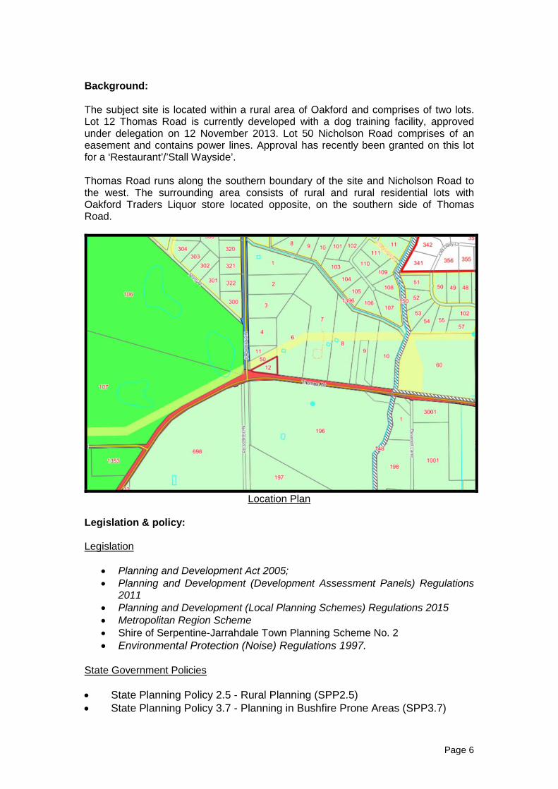
Background: The subject site is located within a rural area of Oakford and comprises of two lots. Lot 12 Thomas Road is currently developed with a dog training facility, approved under delegation on 12 November 2013. Lot 50 Nicholson Road comprises of an easement and contains power lines. Approval has recently been granted on this lot for a ‘Restaurant’/’Stall Wayside’. Thomas Road runs along the southern boundary of the site and Nicholson Road to the west. The surrounding area consists of rural and rural residential lots with Oakford Traders Liquor store located opposite, on the southern side of Thomas Road.
Location Plan
Legislation & policy: Legislation
• Planning and Development Act 2005; • Planning and Development (Development Assessment Panels) Regulations
2011 • Planning and Development (Local Planning Schemes) Regulations 2015 • Metropolitan Region Scheme • Shire of Serpentine-Jarrahdale Town Planning Scheme No. 2 • Environmental Protection (Noise) Regulations 1997.
State Government Policies • State Planning Policy 2.5 - Rural Planning (SPP2.5) • State Planning Policy 3.7 - Planning in Bushfire Prone Areas (SPP3.7)
Page 6

• Environmental Protection Authority Guidance for the Assessment of Environmental Factors Separation Distances between Industrial and Sensitive Land Uses (2005)
Local Policies • Shire of Serpentine Jarrahdale Rural Strategy Review 2013 • Local Planning Policy 4.11 - Advertising (LPP4.11) • Local Planning Policy 1.6 - Public Art (LPP1.6) • Local Planning Policy - Landscape and Vegetation (LPP67) Consultation: Public Consultation Advertising has been undertaken to adjoining landowners for a period of 21 days between 5 April 2018 and 26 April 2018. During this period a total of nine submissions were received from nearby landowners. Seven submissions raised concerns in relation to the proposal and two provided support. The concerns raised are outlined and addressed in the table below. A full summery of the submissions and the applicants response can be viewed as Attachment 2. Issue Raised Officer’s comments Increase in Traffic Safety of intersection Noise Light Spill
Noted – Refer to Traffic section of report Noted – Refer to Traffic section of report Noted. It is considered that the majority of customers to the proposal would be generated from existing passing by traffic. It is acknowledged that the proposal would result in some additional traffic however Thomas Road is a primary regional road. The applicant has commented that Main Roads are to upgrade the road from a RAV4 to a RAV6. This will result in additional heavy vehicles. It is considered that due to the nature of the road network in this area, the proposal would not result in an undue level of traffic noise. With regard to other noise types from the proposal refer to Amenity section of report. A lighting plan has not been submitted as part of the application. This will be recommended as a condition, if approved, to ensure compliance with the
Page 7

Impact on access for Oakford Liquor Store
Australian Standard. The Shire’s Infrastructure Services do not consider there to be a conflict between the approved crossover for the lot opposite and the proposal. It will be for Main Roads to determine if they are satisfied with the access and egress on Thomas Road. MRWA have provided support for the proposal subject to conditions.
Consultation with other Agencies or Consultants Main Roads WA The application was referred to MRWA. Initially objections were raised in relation to the ultimate access arrangements, as the crossover on Nicolson Road would have been located within the pre-deflection area of the future roundabout. Following this submission, negotiations have taken place between the applicant and MRWA to try to amend to the proposal taking into account these comments. The applicant has submitted amended plans incorporating diagonal pavement markings to the road shoulders of Nicholson Road to give the impression of a narrowing carriageway, encouraging drivers to slow down. This mechanism would replace the requirement for a pre-defection area. MRWA have advised that the amendments are to their satisfaction and have provided support for the proposal subject to conditions. Department of Planning Lands and Heritage The Department of Planning, Lands and Heritage advised they have no objections to the proposed access arrangements, subject to adequate separation being achieved between the Thomas Road access point and the service road. However, final endorsement regarding access should be sought from Main Roads. Western Power Western Power have advised that as the proposal is located near to energised electrical installations and powerlines, the person in control of the work site must ensure that no person, plant or material enters the “Danger Zone” of an overhead powerline or other electrical network assets. These comments have been referred to the applicant for information purposes.
Page 8
Planning assessment: Local Planning Scheme Land Use: In considering the land use of the proposal, Officers have considered the land uses of ‘Service Station’ and ‘Convenience Store’ defined under TPS2 as follows”- ‘Service Station’ “means land and buildings used for the supply of petroleum products and motor vehicle accessories and for carrying out greasing, tyre repairs and minor mechanical repairs and may include a cafeteria, restaurant or shop incidental to the primary use; but does not include transport depot, panel beating, spray painting, major repairs or wrecking”. The proposal seeks approval for the sale of petroleum products and includes a shop. The proposal could therefore reasonably be considered to fall within the land use of ‘Service Station’ however, it does not include the carrying out of greasing, tyre repairs or minor mechanical repairs. ‘Convenience Store’ “means land and buildings used for the retail sale of convenience goods being those goods commonly sold in supermarkets, delicatessens and newsagents but including the sale of petrol and operated during hours which include but which may extend beyond normal trading hours and providing associated parking. The buildings associated with a convenience store shall not exceed 300 square metres gross leasable area”. The proposal could also reasonably fall within the definition of ‘Convenience Store’ as it includes the retail sale of convenience goods and petrol. This definition also includes operating hours outside of normal trading hours. ‘Building’ is defined under TPS2 as having “the same meaning as is given to it in and for the purposes of the Residential Planning Codes’ which includes any structure. Therefore, as the buildings associated with the use, including the areas under the canopies, exceed 300 square metres gross leasable area, it is considered that the proposal is excluded from this definition and therefore best fits within the land use of ‘Service Station’ There are no development standards and requirements in the ‘Rural’ zone under TPS2. Clause 5.10.1 of TPS2 states “the purpose and intent of the Rural Zone is to allocate land to accommodate the full range of rural pursuits and associated activities conducted in the Scheme Area”. Although the proposal does not specifically fall within a ‘rural pursuit’, the proposed land use is one which can be considered in the ‘Rural’ zone under the zoning table. It is considered that the proposal would provide a service for passing traffic and local residents and would not adversely impact on the TPS2 objective.
Page 9
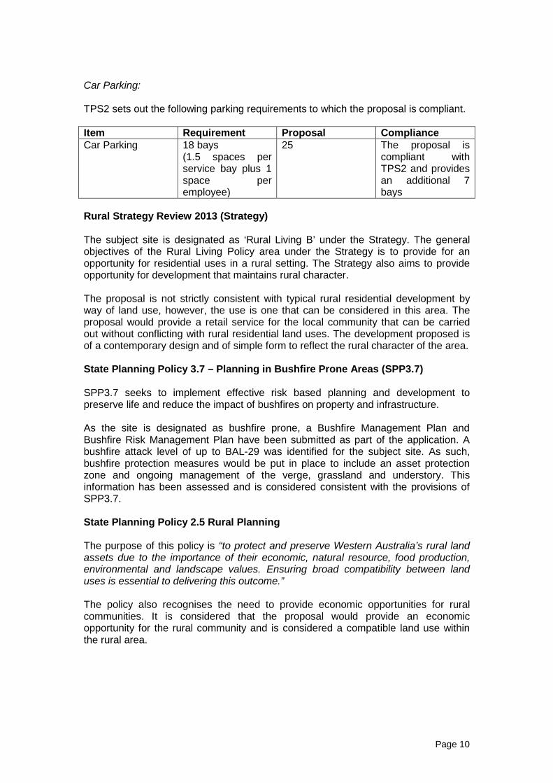
Car Parking: TPS2 sets out the following parking requirements to which the proposal is compliant. Item Requirement Proposal Compliance Car Parking 18 bays
(1.5 spaces per service bay plus 1 space per employee)
25 The proposal is compliant with TPS2 and provides an additional 7 bays
Rural Strategy Review 2013 (Strategy) The subject site is designated as ‘Rural Living B’ under the Strategy. The general objectives of the Rural Living Policy area under the Strategy is to provide for an opportunity for residential uses in a rural setting. The Strategy also aims to provide opportunity for development that maintains rural character. The proposal is not strictly consistent with typical rural residential development by way of land use, however, the use is one that can be considered in this area. The proposal would provide a retail service for the local community that can be carried out without conflicting with rural residential land uses. The development proposed is of a contemporary design and of simple form to reflect the rural character of the area. State Planning Policy 3.7 – Planning in Bushfire Prone Areas (SPP3.7) SPP3.7 seeks to implement effective risk based planning and development to preserve life and reduce the impact of bushfires on property and infrastructure. As the site is designated as bushfire prone, a Bushfire Management Plan and Bushfire Risk Management Plan have been submitted as part of the application. A bushfire attack level of up to BAL-29 was identified for the subject site. As such, bushfire protection measures would be put in place to include an asset protection zone and ongoing management of the verge, grassland and understory. This information has been assessed and is considered consistent with the provisions of SPP3.7. State Planning Policy 2.5 Rural Planning The purpose of this policy is “to protect and preserve Western Australia’s rural land assets due to the importance of their economic, natural resource, food production, environmental and landscape values. Ensuring broad compatibility between land uses is essential to delivering this outcome.” The policy also recognises the need to provide economic opportunities for rural communities. It is considered that the proposal would provide an economic opportunity for the rural community and is considered a compatible land use within the rural area.
Page 10

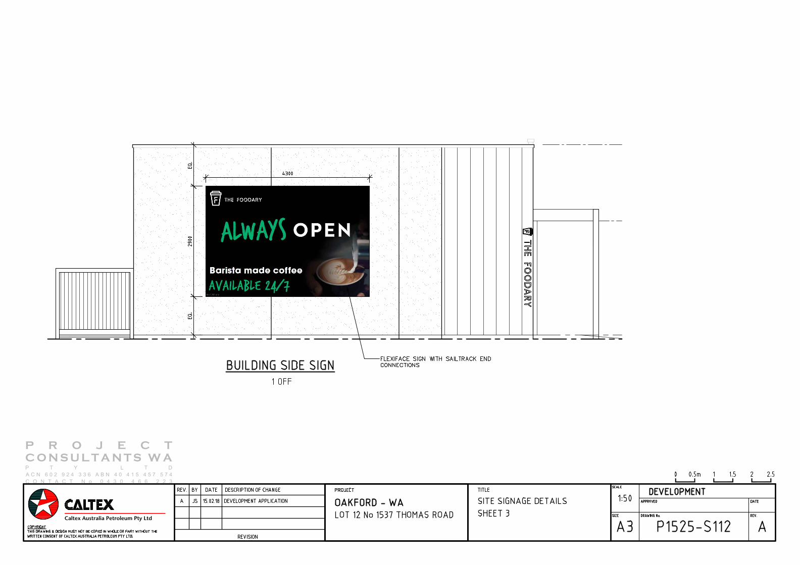
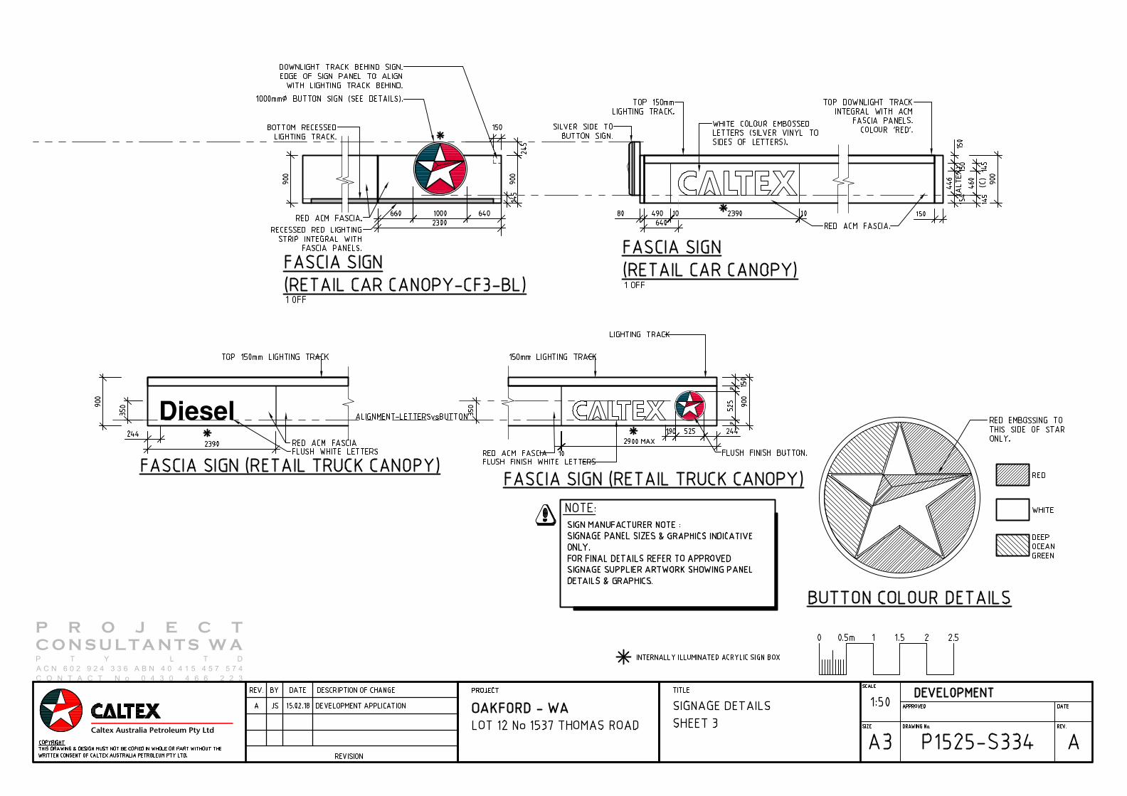
Form of Development The retail building is proposed to be located centrally to the site and orientated with the entrance and primary frontage to Thomas Road. The materials are of earthy tones with the use of cladding and face brick panelling. It is considered that the use of colours and materials reflects the rural character of the area. The light vehicle bowsers are located to the south of the building fronting Thomas road with the heavy vehicle bowsers towards the rear of the lot. The plant and service yards are located behind the building, which does not adversely affect the rural character of the streetscape. The proposal includes landscaping along the boundaries of the subject site and retail building. The landscaping is focussed within Lot 12 where the buildings and structures are proposed. Comments were received from the Shire’s Environmental Officers who raised concerns in relation to the adequacy of the landscaping and that it does not fully replace the trees that would be lost as part of the development. Officers consider that a condition requiring an amended landscaping plan would allow further landscaping measures to address these concerns. Signage: The proposal also includes the following signage as follows:-
• One 5.5m x 1.25m “The Foodary’ fascia sign to the southern elevation of the convenience store;
• One 4.3m x 2.9m on building sign to the eastern elevation of the convenience store;
• One 2.39 x 0.9m and one 2.3m x 0.9m ‘Caltex’ fascia canopy signs located on the south and west facades of the light vehicle fuel canopy;
• One 2.9m x 0.9m and one 2.93m x 0.9m ‘Caltex’ canopy fascia signs located on the heavy vehicle canopy;
• One 20m high internally illuminated pylon sign fronting Thomas Road. This sign would incorporate panels for ‘Caltex’ and ‘The Foodary’ as well as advertising panels and digital displays detailed the fuel offerings;
• One 2.3m high internally illuminated promotion sign fronting Thomas Road adjacent to the crossover point.
Local Planning Policy LPP 4.11 – Advertising sets out development standards and requirements for advertisements. The objectives of this policy are to ensure that signage does not detract from the character of the area and makes a positive contribution to the streetscape. It also aims to ensure that the scale of signage is appropriate to the size of the façade of buildings on which it is displayed. The table below shows the proposed signage addressed against the policy requirements. Any variations are discussed further in the report and assessed against the objectives of the policy. Signage Signage
type Requirement Compliant Variation
Service Station Canopy Signs
Canopy Signs
• Is a single faced sign.
• Must be compatible with the canopy and building on
Yes Yes Yes
N/A N/A N/A
Page 11

which it is displayed. • Must
not be illuminated unless the nature of the illumination and/or materials is such as to prevent combustion.
• Must have a minimum clearance of 2.75m to any rigid part of the canopy, and 2.4m to any flexible part of the canopy, and a footpath pavement, where pedestrian access is to be maintained.
Yes
N/A
‘The Foodary’ Sign
Roof Sign • A maximum area of 20% of the area of the roof panel on which it is located or 4m2 whichever is the lesser.
• A maximum width of 2/3 of the width of the roof.
• Does not protrude above the roof ridge line.
• Does not project more than 300mm from the portion of the building to which it is attached.
No Yes Yes
6.9m2 N/A N/A
On Building Sign
Wall Sign • A wall sign is to only to display the name, logo or slogan of the business premises to which the sign is applied.
• The maximum single face area is 10m2, and must not extend beyond 12.0m above the ground even if the wall is higher than this.
• Must not project more than 300mm from the wall and/or fascia to which it is affixed.
• Must not project beyond the edges of a wall and/or fascia.
• A wall sign, which extends above a wall, may be considered as a roof sign.
Yes No Yes Yes Yes
N/A 12.5m2
N/A
N/A N/A
Pylon Sign Pylon • The maximum sign face area is 10m2 per face, for a maximum of two faces.
• The maximum height above the ground is to be 6.5m or the height of a building in close proximity, whichever is the greater, but is not to exceed 10m. The height of a building is defined as the height of the uppermost part of the building above ground level.
• Must be mounted as a free-standing structure.
• Must not be located less than 1.5m from the front property boundary (including the primary and secondary street frontages of a corner lot), and must not project beyond the alignment of any property boundary.
• Must
No No Yes Yes Yes
Exceeds 10m2
20m high 90.2m2
N/A N/A N/A
Page 12

not face adjoining premises unless the sign is a minimum of 3.0m from the property boundary of that premises, or unless the landowner of the adjoining premises consents to the sign being a lesser distance from the boundary.
• Must not expose an unsightly back view of the sign to a road or other public place. Must not to be located on a street frontage of a premises along which is located another pylon sign, billboard sign or pole sign.
Yes
N/A
Variations: The Foodary Sign This sign is proposed to have an area of 6.9m2 in lieu of the policy requirement of 4m2. The applicant has provided a justification to the variation and stated that this sign functions as a point of identification for the entrance. It is the only sign on the front of the building and proportionally reflects the scale of the building and the architectural design. Officers consider that as the signage comprises of white coloured individual letters, it would not appear intrusive or excessive. It is considered that in this instance the sign would not dominate the elevation of the building due to its scale or have an adverse impact on the character of the area. As such, the proposed sign is considered consistent with the objectives of the policy and the variation is supported by Officers. On Building Sign The on building sign is proposed to be 12.5m2 in lieu of 10m2 as per the policy requirement. As with the ‘Foodary’ sign, Officers consider that the scale of the sign is consistent with the scale of the building and as such would not appear intrusive or excessive. Officers consider this signage is consistent with objectives of the policy and would not adversely impact on the character of the area. Pylon Sign The application seeks approval for a 20m high pylon sign, each face of the sign exceeding 10m2 in area. This is significantly higher than what is allowed under LPP 4.11. The applicant has provided a justification that the sign is required to provide early identification of the site and that existing vegetation would impact its visibility if it were smaller. The applicant also notes that the proposal does not impact on sightlines from the intersection or the crossovers. Additional information has been provided to further justify their position in the form of photomontages, contained within attachment 3. Officers acknowledge that Thomas Road is a busy road and not a typical country road, however the streetscape maintains the areas rural character. The addition of signage of such a significant scale is considered to be an incongruous addition to the rural streetscape. Officers consider that the scale of the pylon sign would adversely impact on the rural character and amenity of the area. It is acknowledged that early identification is
Page 13
considered important however, 20m is considered a significant variation that is not supported by Officers. LPP4.11 allows for 6.5m high pylon signs or the same height as a building in close proximity. It is considered that the justification requiring early identification does not outweigh the need to maintain the rural character of the area. A 20m high pylon sign would be 13.5m higher than the canopy for the truck fuelling. It is considered that the height of this sign would appear at odds with the scale of the development on the site and the surrounding area. Due to the location of the sign, it would appear visually intrusive within the streetscape and adversely impact on the rural character of the area. Officers propose a condition to ensure that the pylon sign is reduced significantly in height. Traffic, Access and Safety Thomas Road is identified as a Primary Regional Road and designated freight route. Nicholson Road is identified as an Other Regional Road. Both of these classes of roads are designed to carry larger volumes of traffic. Access and egress to the site is proposed to be taken from both Thomas Road and Nicolson Road. Access from Thomas Road is to be left-in for both light and heavy vehicles and left out for light vehicles only. All heavy vehicles would be required to ingress via Thomas Road. The access from Nicholson Road will be left-in for light vehicles only and left-out for light and heavy vehicles. The applicant states that the site has been designed to accommodate access and parking for heavy vehicles up to 36.5m B-double standard. Concerns were raised during the advertising period relating to the potential safety and access issues resulting from the potential increased traffic on Thomas Road and the capability of the existing network infrastructure to accommodate increased traffic volumes. A Transport Impact Assessment has been submitted as part of the application. This shows that the majority of trade would be from existing passing traffic through Thomas and Nicholson Road. The assessment findings conclude that the proposal is estimated to result in an additional 16 and 22 trips during the AM and PM peak periods respectively. It is noted that currently the intersection suffers from capacity shortages during peak periods, however once upgraded as proposed, there will be adequate capacity. The applicant has acknowledged that the Thomas Road and Nicolson Road intersection is subject to a future upgrade. Consultation has been undertaken with MRWA to ensure the upgrades would not prevent or prejudice the access arrangements for the proposal. The proposal has been designed to accommodate the future upgrades to the Thomas Road and Nicholson Road intersection and a concept plan has been provided for what potentially will be the ultimate access arrangements and for the interim arrangements. Although the future plans are not yet in place it is envisaged that a two lane roundabout will be constructed at the intersection. Initially, concerns were raised by MRWA in relation to the ultimate access arrangements due to the crossover on Nicolson Road being located within the pre-deflection area of the future roundabout. Subsequently, further discussions have been undertaken with MRWA and the access arrangements have been amended
Page 14

accordingly, to the satisfaction of MRWA. The access arrangements are proposed to be over three phases. Phase 1 is based on the current configuration prior to any road upgrades. It involves provision of a left-in slip lane for the Nicholson Road access and a left-in slip lane for the access on Thomas Road to ensure all vehicles are able to safely manoeuvre into the subject site without impacting the movements of traffic along Thomas and Nicolson Road. Median islands are also included opposite both crossovers to prevent right-turn traffic movements. There would be small paved islands in the centre of both crossovers to delineate the flow of traffic. In addition, a signage strategy and road markings are proposed to ensure safe and correct movement of all vehicles. Phase 2 consists of an interim roundabout estimated to be completed by MRWA within 12-18 months. To maintain a safe approach to the intersection following construction of the roundabout, Nicholson Road would incorporate diagonal pavement markings to the road shoulders to give the impression of a narrowing carriageway, encouraging drivers to slow down. This is the proposed alternative to a pre-deflection area as was initially opposed by MRWA. Phase 2 is provided as a concept only to demonstrate that safe access to the subject site can be maintained following road upgrades. The detailed design and construction of the roundabouts will be the responsibility of MRWA. Modifications to the access and egress of the proposal are not required to facilitate the Phase 2 interim roundabout upgrades. Phase 3 provides an ultimate arrangement for the long term plans for the road network. This is anticipated to be carried out during the next 15 to 20 years. This ultimate scenario is therefore a long term consideration which is understood to still be undergoing design and funding arrangements. It is considered that the applicant has demonstrated the proposal would not adversely impact on traffic safety and MRWA have confirmed that their initial concerns have been addressed. Amenity The proposal would operate 24 hours per day, seven days a week. Due to the existing traffic volumes on both Nicolson and Thomas Road, it is considered that the proposal would not adversely impact on adjoining landowners by way of traffic noise due to the additional traffic numbers provided within the Transport Assessment. It is acknowledged that additional noise would be resultant from the operations of the facility. The EPA Guidelines require a separation distance of 100m between service stations and sensitive receptors. In this case, the proposal is compliant with this requirement. Furthermore, the EPA Guidelines set this standard for service stations that include vehicle cleaning/detailing which are not proposed as part of this application and are considered to result in more noise than what is being applied for in this case. This 100m separation distance is also required for freeway service centres which also operate 24hrs. To satisfy any noise sources from the running of the business and to mitigate the impact on adjoining residents, Officers recommended a condition requiring a Noise
Page 15

Assessment/Management Plan to identify any additional sources of noise and provide details of how these would be managed. One of the concerns raised during the advertising period related to light spill. A lighting plan would also be required as a condition to ensure any lighting would not adversely impact on the amenity of neighbouring properties. Landscaping is a significant contribution towards the amenity of rural areas. LPP67 sets out requirements for landscaping and vegetation and its objective is to “Contribute towards achievement of vegetation and landscape outcomes that meet the expectations of stakeholders and contribute towards the achievement of biodiversity and water use targets and the creation of vibrant places for our communities”. The applicant has provided information that landscaping will be undertaken to offset the loss of trees from the site. A condition will require for an amended detailed landscaping plan to be prepared and approved by the Shire prior to commencement of works. The landscaping plan will be required to be in accordance with LPP67 and further compensate for the vegetation that would be lost as part of the development. Other Considerations Local Planning Policy 1.6 - Public Art (LPP1.6) The objectives of LPP1.6 is to facilitate public art to enhance public enjoyment, engagement and understanding of places through the integration of public art. The policy sets out the requirements for physical and financial contributions for public art for any development valued at $1 million or greater. A condition would require the applicant to contribute towards public art in accordance with the policy. Council Recommendation: Approve subject to conditions. Conclusion: The application seeks approval for a ‘Service Station’. The proposal would be located on the corner of a Primary Regional Road and an Other Regional Road providing goods and petroleum for passing traffic. The proposal would also provide for a retail service for residents of the local area. The application is considered consistent with the planning framework and the principles of orderly and proper planning. The applicant has demonstrated that the future access arrangements will not prejudice the future planned road upgrades. The proposal is therefore supported by Officers.
Page 16
DRAWINGS LISTGENERAL
SITE WORKS
SHOP
SIGNAGE
LANDSCAPING
RETAIL CAR CANOPY
RETAIL TRUCK CANOPY
TRAFFIC MANGEMENT
Caltex Australia Petroleum Pty Ltd
P R O J E C T
C O N S U L T A N T S W AP T Y L T D
A C N 6 0 2 9 2 4 3 3 6 A B N 4 0 4 1 5 4 5 7 5 7 4
C O N T A C T N o 0 4 3 0 4 6 6 2 2 3
B1
BA
B2B3
B4B5
B6B7
BB
BC
BD
P R O J E C T
C O N S U L T A N T S W AP T Y L T D
A C N 6 0 2 9 2 4 3 3 6 A B N 4 0 4 1 5 4 5 7 5 7 4
C O N T A C T N o 0 4 3 0 4 6 6 2 2 3
P R O J E C T
C O N S U L T A N T S W AP T Y L T D
A C N 6 0 2 9 2 4 3 3 6 A B N 4 0 4 1 5 4 5 7 5 7 4
C O N T A C T N o 0 4 3 0 4 6 6 2 2 3

P R O J E C T
C O N S U L T A N T S W AP T Y L T D
A C N 6 0 2 9 2 4 3 3 6 A B N 4 0 4 1 5 4 5 7 5 7 4
C O N T A C T N o 0 4 3 0 4 6 6 2 2 3

P R O J E C T
C O N S U L T A N T S W AP T Y L T D
A C N 6 0 2 9 2 4 3 3 6 A B N 4 0 4 1 5 4 5 7 5 7 4
C O N T A C T N o 0 4 3 0 4 6 6 2 2 3

B1
BA
B2B3
B4B5
B6B7
BB
BC
BD
·
·
·
·
·
P R O J E C T
C O N S U L T A N T S W AP T Y L T D
A C N 6 0 2 9 2 4 3 3 6 A B N 4 0 4 1 5 4 5 7 5 7 4
C O N T A C T N o 0 4 3 0 4 6 6 2 2 3
B1
BA
B2B3
B4B5
B6B7
BB
BC
BD
P R O J E C T
C O N S U L T A N T S W AP T Y L T D
A C N 6 0 2 9 2 4 3 3 6 A B N 4 0 4 1 5 4 5 7 5 7 4
C O N T A C T N o 0 4 3 0 4 6 6 2 2 3

APPENDIX 3
Proposed development plans – Phase 2

P R O J E C T
C O N S U L T A N T S W AP T Y L T D
A C N 6 0 2 9 2 4 3 3 6 A B N 4 0 4 1 5 4 5 7 5 7 4
C O N T A C T N o 0 4 3 0 4 6 6 2 2 3

2
4
.
3
3
2
4
.
1
5
2
3
.
6
2
2
3
.
6
7
2
3
.
9
5
2
3
.
7
7
2
4
.
0
2
2
3
.
9
6
2
3
.
7
8
2
4
.
0
3
2
4
.
0
5
2
4
.
0
7
2
3
.
7
7
2
3
.
7
7
2
3
.
7
7
2
4
.
1
82
4
.
1
4
2
4
.
0
7
2
4
.
0
6
2
3
.
9
4
2
3
.
9
4
2
3
.
9
6
2
3
.
8
3
2
4
.
2
9
2
4
.
2
8
2
4
.
2
7
2
4
.
2
2
2
4
.
0
8
2
4
.
0
1
2
4
.
1
3
2
4
.
2
0
2
4
.
2
2
2
4
.
2
22
4
.
2
0
2
4
.
2
1
2
3
.
9
9
2
4
.
0
52
4
.
1
5
2
4
.
3
7
2
4
.
2
5
2
4
.
2
5
2
4
.
3
0
2
4
.
1
4
2
4
.
1
2
2
3
.
9
8
2
3
.
9
3
2
3
.
9
2
2
3
.
9
4
2
3
.
9
9
2
4
.
0
6
2
4
.
0
6
2
4
.
0
0
2
4
.
1
8
2
4
.
1
1
2
4
.
1
0
2
4
.
1
8
2
3
.
9
0
2
3
.
7
7
2
3
.
8
0
2
3
.
8
2
2
3
.
8
5
2
3
.
8
8
2
3
.
8
5
2
3
.
8
4
2
3
.
8
1
2
3
.
7
7
2
3
.
8
5
2
3
.
9
7
2
4
.
0
3
2
3
.
4
2
2
3
.
8
1
2
3
.
7
7
2
3
.
7
2
2
3
.
5
5
2
3
.
6
3
2
3
.
6
5
2
3
.
7
0
2
3
.
6
5
2
3
.
8
0
2
3
.
7
7
2
4
.
3
1
2
4
.
2
7
2
4
.
2
4
2
4
.
2
3
2
4
.
1
1
2
4
.
2
2
2
4
.
2
6
2
4
.
2
5
2
4
.
2
7
2
4
.
2
7
2
4
.
2
7
2
4
.
0
2
2
4
.
2
4
2
4
.
2
9
2
4
.
3
5
2
4
.
3
4
2
4
.
1
8
2
3
.
9
8
2
3
.
9
0
2
3
.
8
9
2
3
.
8
9
2
3
.
8
8
2
3
.
8
8
2
3
.
8
7
2
3
.
8
8
2
3
.
9
8
2
4
.
0
0
2
4
.
3
3
2
3
.
8
3
2
3
.
8
0
2
3
.
9
3
2
3
.
8
1
2
3
.
7
4
2
3
.
7
2
2
3
.
7
0
2
3
.
7
2
2
3
.
6
4
2
3
.
7
02
3
.
7
8
2
3
.
8
6
2
3
.
8
8
2
3
.
8
5
2
2
.
8
0
2
3
.
7
4
2
4
.
3
3
2
4
.
1
5
2
3
.
6
2
2
3
.
6
7
2
3
.
9
5
2
3
.
7
7
2
3
.
5
5
2
3
.
5
7
2
3
.
8
7
2
3
.
9
0
2
3
.
5
0
2
3
.
7
0
2
3
.
7
4
2
3
.
5
5
2
3
.
5
1
2
2
.
2
0
2
2
.
3
3
2
2
.
0
6
2
2
.
0
4
2
2
.
5
5
2
2
.
3
6
2
3
.
5
4
2
3
.
3
1
2
3
.
2
5
2
3
.
1
6
2
3
.
1
4
2
3
.
0
7
2
2
.
9
6
2
2
.
7
0
2
2
.
6
9
2
2
.
6
7
2
3
.
2
0
2
3
.
0
4
2
2
.
7
8
2
2
.
8
2
2
2
.
8
4
2
3
.
5
2
2
3
.
3
4
2
3
.
3
4
2
3
.
2
5
2
3
.
1
9
2
3
.
0
5
2
3
.
1
8
2
3
.
1
8
2
2
.
9
8
2
2
.
9
7
2
2
.
9
4
2
3
.
0
3
2
3
.
1
9
2
3
.
2
0
2
3
.
2
1
2
3
.
3
0
2
3
.
4
5
2
3
.
6
4
2
3
.
4
6
2
3
.
3
9
2
3
.
7
0
2
3
.
6
6
2
3
.
5
1
2
3
.
6
1
2
3
.
5
3
2
3
.
9
7
2
3
.
9
2
2
3
.
0
6
2
2
.
9
9
2
3
.
0
2
2
3
.
4
9
2
3
.
7
0
2
3
.
6
5
2
3
.
7
2
2
3
.
6
3
2
2
.
3
0
2
2
.
4
8
2
2
.
4
8
2
2
.
4
5
2
2
.
2
9
2
2
.
5
5
2
2
.
8
7
2
3
.
4
0
2
3
.
3
5
2
3
.
2
5
2
3
.
1
2
2
3
.
6
02
3
.
8
7
2
3
.
7
4
2
3
.
9
7
2
4
.
0
6
2
4
.
0
7
2
3
.
9
0
2
3
.
9
3
2
4
.
0
7
2
4
.
0
3
2
4
.
0
5
2
4
.
0
0
2
3
.
8
9
2
4
.
1
3
2
3
.
4
5
2
3
.
5
7
2
3
.
3
0
2
3
.
2
8
2
3
.
5
6
2
3
.
5
4
2
3
.
5
5
2
3
.
5
9
2
3
.
6
8
2
3
.
5
9
2
3
.
6
1
2
3
.
7
6
2
3
.
7
5
2
3
.
7
6
2
3
.
8
0
2
3
.
9
5
2
3
.
8
6 2
3
.
6
7
2
3
.
5
6
2
3
.
8
2
2
3
.
2
9
2
3
.
3
0
2
3
.
3
9
2
3
.
4
8
2
4
.
2
1
2
4
.
2
2
2
4
.
0
1
2
3
.
5
6
2
3
.
8
2
2
3
.
3
0
2
3
.
3
7
2
4
.
0
5
2
4
.
2
5
2
4
.
0
9
2
3
.
7
9
2
3
.
6
8
2
3
.
7
0
2
3
.
8
8
2
3
.
7
1
2
2
.
8
8
2
4
.
0
2
2
3
.
9
6
2
3
.
7
8
2
4
.
0
3
2
4
.
0
5
2
4
.
0
7
2
3
.
7
7
2
3
.
7
7
2
3
.
7
7
2
4
.
1
82
4
.
1
4
2
4
.
0
7
2
4
.
0
6
2
3
.
9
4
2
3
.
9
4
2
3
.
9
6
2
3
.
8
3
2
4
.
2
9
2
4
.
2
8
2
4
.
2
7
2
4
.
2
2
2
4
.
0
8
2
4
.
0
1
2
4
.
1
3
2
4
.
2
0
2
4
.
2
2
2
4
.
2
22
4
.
2
0
2
4
.
2
1
2
4
.
1
9
2
3
.
9
9
2
4
.
0
52
4
.
1
5
2
4
.
3
7
2
4
.
2
5
2
4
.
2
5
2
4
.
3
0
2
4
.
1
4
2
4
.
1
2
2
3
.
9
8
2
3
.
9
3
2
3
.
9
2
2
3
.
9
4
2
3
.
9
9
2
4
.
0
6
2
4
.
0
6
2
4
.
0
0
2
4
.
1
8
2
4
.
1
5
2
4
.
1
1
2
4
.
1
0
2
4
.
1
8
2
3
.
9
0
2
3
.
7
7
2
3
.
8
0
2
3
.
8
2
2
3
.
8
5
2
3
.
8
8
2
3
.
8
5
2
3
.
8
4
2
3
.
8
1
2
3
.
7
7
2
3
.
8
5
2
3
.
9
7
2
4
.
0
3
2
3
.
8
1
2
3
.
7
7
2
3
.
7
2
2
3
.
5
5
2
3
.
6
3
2
3
.
6
5
2
3
.
7
0
2
3
.
6
5
2
3
.
8
0
2
3
.
7
7
2
4
.
3
1
2
4
.
2
7
2
4
.
2
4
2
4
.
2
3
2
4
.
2
3
2
4
.
1
1
2
4
.
2
2
2
4
.
2
6
2
4
.
2
5
2
4
.
2
7
2
4
.
2
7
2
4
.
2
7
2
4
.
0
2
2
4
.
2
4
2
4
.
2
9
2
4
.
3
5
2
4
.
3
4
2
4
.
1
8
2
3
.
9
8
2
3
.
9
0
2
3
.
8
9
2
3
.
8
9
2
3
.
8
8
2
3
.
8
8
2
3
.
8
7
2
3
.
8
8
2
3
.
9
8
2
4
.
0
0
2
4
.
3
3
2
3
.
8
3
2
3
.
8
0
2
3
.
8
0
2
3
.
9
3
2
3
.
8
1
2
3
.
7
4
2
3
.
7
2
2
3
.
7
0
2
3
.
7
2
2
3
.
6
4
2
3
.
7
02
3
.
7
8
2
3
.
8
6
2
3
.
8
8
2
3
.
8
5
2
3
.
8
4
2
3
.
3
4
2
3
.
5
8
2
3
.
7
7
2
3
.
9
3
2
3
.
9
5
2
3
.
4
7
2
3
.
5
1
2
2
.
4
7
2
3
.
2
5
2
3
.
8
3
2
3
.
5
4
2
3
.
3
9
2
3
.
1
4
2
2
.
9
1
2
2
.
8
8
2
2
.
2
9
2
2
.
4
4
2
2
.
5
5
2
3
.
1
8
2
3
.
9
5
2
3
.
8
02
3
.
8
2
2
3
.
9
9
2
3
.
7
7
2
3
.
7
4
2
3
.
9
3
2
4
.
0
2
2
3
.
9
4
2
3
.
9
5
2
3
.
7
8
2
3
.
6
8
2
3
.
5
8
2
3
.
5
4
2
3
.
6
5
2
3
.
8
3
2
3
.
9
1
2
3
.
7
7
2
3
.
6
4
2
3
.
5
4
2
3
.
5
3
2
3
.
7
5
2
3
.
6
7
2
2
.
7
6
2
2
.
9
5
2
2
.
6
1
2
2
.
7
1
2
2
.
6
4
2
2
.
6
8
2
2
.
9
0
2
2
.
9
4
2
2
.
7
7
2
2
.
8
9
2
3
.
8
2
2
3
.
6
3
2
3
.
4
8
2
3
.
6
5
2
3
.
6
7
2
3
.
5
7
2
3
.
4
3
2
2
.
8
0
2
3
.
9
8
2
2
.
6
2
2
4
.
2
7
2
3
.
9
6
2
2
.
3
8
2
3
.
6
6
2
2
.
7
1
2
2
.
5
7
2
3
.
8
4
2
3
.
8
0
2
4
.
1
0
2
3
.
0
6
2
3
.
3
3
2
3
.
3
8
2
3
.
3
6
2
3
.
8
9
2
3
.
6
6
2
2
.
9
5
2
3
.
1
2
2
3
.
4
2
2
3
.
4
3
2
3
.
3
4
2
3
.
3
4
2
3
.
3
1
2
3
.
2
0
2
3
.
3
8
2
3
.
6
4
2
3
.
4
1
2
3
.
4
1
2
3
.
1
6
2
3
.
5
2
2
3
.
5
2
2
3
.
5
1
2
3
.
0
9
2
3
.
2
3
2
3
.
1
1
2
3
.
3
1
2
3
.
1
9
2
3
.
5
6
2
3
.
2
3
2
3
.
6
1
2
3
.
2
2
2
3
.
2
1
2
3
.
2
1
2
3
.
1
8
2
2
.
9
2
2
2
.
5
0
2
3
.
0
4
2
3
.
1
7
2
3
.
0
1
2
3
.
2
8
2
3
.
2
9
2
3
.
2
9
2
3
.
4
0
2
3
.
5
2
2
3
.
5
5
2
3
.
8
9
2
3
.
8
7
2
3
.
9
7
2
3
.
8
2
2
3
.
7
2
2
3
.
8
6
2
4
.
0
3
2
3
.
9
9
2
3
.
9
7
2
3
.
9
2
2
3
.
8
1
2
3
.
8
6
2
3
.
7
8
2
3
.
2
72
3
.
1
8
2
3
.
6
1
2
3
.
5
8
2
3
.
6
4
2
3
.
3
72
3
.
4
6
2
3
.
9
0
48.599
2
4
.
7
6
9
2
0
.
6
0
6
173.196
2
1
6
.
3
8
4
1
33
.6
80
2
2
.0
0
2
2
.0
0
22.00
22.0
0
22.0
0
22.00
2
3
.
0
0
23.00
23.00
23.0
0
23.00
23.00
23.0
0
2
3
.0
0
2
3
.
0
0
2
3
.
0
0
2
3
.0
0
23.0
0
2
3
.0
0
2
4
.
0
0
2
4
.
0
0
2
4
.
0
0
2
4
.
0
0
2
4
.0
0
2
4
.
0
0
24.00
D900
D1200
D
1
2
0
0
D700
O
PE
N D
RA
IN
O
PE
N D
RA
IN
O
PE
N D
RA
IN
O
P
E
N
D
R
A
I
N
I
.
L
.
N
O
T
S
H
O
W
N
O
PE
N D
RA
IN
O
VE
RG
RO
W
N
SU
M
P/R
ET
EN
TIO
N
PO
ND
CABLE
MARKER
LIGHT
POLE
LIGHT
POLE
LIGHT
POLE
LIGHT
POLE
LIGHT
POLE
LIGHT
POLE
POLE
POWER
POLE
POWER
POLE
POWER
POLE
POWER
POLE
POWER
POLE
POWER
POLE
POWER
POLE
POWER
POLE
POWER
POLE
POWER
POLE
POWER
STAY
WIRE
STAY
WIRE
LIM
ES
TO
NE
TR
AC
K
L
I
M
E
S
T
O
N
E
T
R
A
C
K
N
GHD STANDARD A1 ATTRIBUTE BLOCK CAD File No.: GHD_G_0045_T Updated: 08-07-03 Version: 1.1GHD STANDARD A1 SHEET CAD File No.: GHD_G_0045 Updated: 08-07-03 Version: 1.1
DateDrawnRevisionNo
SURVEYOR:
DRAWN:
CHECKED:
JOB No.
DATUM: DATE:
CCAD FILE:
SITE:
TITLE:
DWG NO.
SCALE
GRID:
1:500 (AT A1 SIZE)
CLIENT:
LOT 12 THOMAS RD
OAKFORD
FEATURE SURVEY
Elton Swartz
17-12
AHD
PCG 94
SB
3/5/17
NP
SB
17-12-FS-01
THOMAS RD R1
NOTES:
1. BOUNDARIES ARE INDICATIVE ONLY & ARE SUBJECT TO SURVEY.
2. LOCATIONS OF SEWER MAINS ARE FOR ILLUSTRATION PURPOSES ONLY, AND
SHOULD ONLY BE USED FOR AN APPROXIMATE LOCATION.
3. REFER TO CERTIFICATE OF TITLE FOR EASEMENTS AND OTHER INTERESTS /
ENCUMBRANCES.
4. AHD HEIGHTS DERIVED FROM STATE SURVEY MARK.
5. LOCATIONS OF POWER LINES ARE FOR ILLUSTRATION PURPOSES ONLY, AND
SHOULD BE CONFIRMED
R 2
7/5/17SB
ADDED PIPE DIA, ADDED POWER POLE,ADDED TEXT,
2
ADDED APPROX BLD OUTLINE, NOTE AMMENED

6g CSK 38" inch
total joined lead weight 92x36approx 31.4 kg/m
10g CSK 1 inch
10g CSK 1 inch
EP15841EP15841EP15841EP15841
6g CSK 38" inch
total joined lead weight 92x36
approx 31.4 kg/m
10g CSK 1 inch
10g CSK 1 inch
6g CSK 38" inch
total joined lead weight 92x36approx 31.4 kg/m
10g CSK 1 inch
10g CSK 1 inch
6g CSK 38" inch
total joined lead weight 92x36approx 31.4 kg/m
10g CSK 1 inch
10g CSK 1 inch
6g CSK 38" inch
total joined lead weight 92x36approx 31.4 kg/m
10g CSK 1 inch
10g CSK 1 inch
6g CSK 38" inch
total joined lead weight 92x36approx 31.4 kg/m
10g CSK 1 inch
10g CSK 1 inch
EP15841EP15841
6g CSK 38" inch
total joined lead weight 92x36
approx 31.4 kg/m
10g CSK 1 inch
10g CSK 1 inch
6g CSK 38" inch
total joined lead weight 92x36approx 31.4 kg/m
10g CSK 1 inch
10g CSK 1 inch
6g CSK 38" inch
total joined lead weight 92x36
approx 31.4 kg/m
10g CSK 1 inch
10g CSK 1 inch
6g CSK 38" inch
total joined lead weight 92x36approx 31.4 kg/m
10g CSK 1 inch
10g CSK 1 inch
P R O J E C T
C O N S U L T A N T S W AP T Y L T D
A C N 6 0 2 9 2 4 3 3 6 A B N 4 0 4 1 5 4 5 7 5 7 4
C O N T A C T N o 0 4 3 0 4 6 6 2 2 3
HAZMAT
ALL FUELEMERGENCY
STOPPUSH BUTTON
NightCounter
Caltex Australia Petroleum Pty Ltd
P R O J E C T
C O N S U L T A N T S W AP T Y L T D
A C N 6 0 2 9 2 4 3 3 6 A B N 4 0 4 1 5 4 5 7 5 7 4
C O N T A C T N o 0 4 3 0 4 6 6 2 2 3

Caltex Australia Petroleum Pty Ltd
P R O J E C T
C O N S U L T A N T S W AP T Y L T D
A C N 6 0 2 9 2 4 3 3 6 A B N 4 0 4 1 5 4 5 7 5 7 4
C O N T A C T N o 0 4 3 0 4 6 6 2 2 3

*
*
*
*
*
P R O J E C T
C O N S U L T A N T S W AP T Y L T D
A C N 6 0 2 9 2 4 3 3 6 A B N 4 0 4 1 5 4 5 7 5 7 4
C O N T A C T N o 0 4 3 0 4 6 6 2 2 3
Caltex Australia Petroleum Pty Ltd
*
***
$
Litres
*
**
***
****
***
*
*** ***
P R O J E C T
C O N S U L T A N T S W AP T Y L T D
A C N 6 0 2 9 2 4 3 3 6 A B N 4 0 4 1 5 4 5 7 5 7 4
C O N T A C T N o 0 4 3 0 4 6 6 2 2 3
Caltex Australia Petroleum Pty Ltd

Litres
$
*
****
*
**
***
****
*
********
CANOPY - FINISHES SCHEDULE
P R O J E C T
C O N S U L T A N T S W AP T Y L T D
A C N 6 0 2 9 2 4 3 3 6 A B N 4 0 4 1 5 4 5 7 5 7 4
C O N T A C T N o 0 4 3 0 4 6 6 2 2 3
Caltex Australia Petroleum Pty Ltd
P R O J E C T
C O N S U L T A N T S W AP T Y L T D
A C N 6 0 2 9 2 4 3 3 6 A B N 4 0 4 1 5 4 5 7 5 7 4
C O N T A C T N o 0 4 3 0 4 6 6 2 2 3
Caltex Australia Petroleum Pty Ltd

Clearance 5.5mDiesel
24 hr Card
P R O J E C T
C O N S U L T A N T S W AP T Y L T D
A C N 6 0 2 9 2 4 3 3 6 A B N 4 0 4 1 5 4 5 7 5 7 4
C O N T A C T N o 0 4 3 0 4 6 6 2 2 3
Caltex Australia Petroleum Pty Ltd

P R O J E C T
C O N S U L T A N T S W AP T Y L T D
A C N 6 0 2 9 2 4 3 3 6 A B N 4 0 4 1 5 4 5 7 5 7 4
C O N T A C T N o 0 4 3 0 4 6 6 2 2 3
Caltex Australia Petroleum Pty Ltd
P R O J E C T
C O N S U L T A N T S W AP T Y L T D
A C N 6 0 2 9 2 4 3 3 6 A B N 4 0 4 1 5 4 5 7 5 7 4
C O N T A C T N o 0 4 3 0 4 6 6 2 2 3
Caltex Australia Petroleum Pty Ltd
P R O J E C T
C O N S U L T A N T S W AP T Y L T D
A C N 6 0 2 9 2 4 3 3 6 A B N 4 0 4 1 5 4 5 7 5 7 4
C O N T A C T N o 0 4 3 0 4 6 6 2 2 3
Diesel
P R O J E C T
C O N S U L T A N T S W AP T Y L T D
A C N 6 0 2 9 2 4 3 3 6 A B N 4 0 4 1 5 4 5 7 5 7 4
C O N T A C T N o 0 4 3 0 4 6 6 2 2 3
Caltex Australia Petroleum Pty Ltd

ULP
VortexDiesel
LPG
V95
AdBlue
P R O J E C T
C O N S U L T A N T S W AP T Y L T D
A C N 6 0 2 9 2 4 3 3 6 A B N 4 0 4 1 5 4 5 7 5 7 4
C O N T A C T N o 0 4 3 0 4 6 6 2 2 3
Caltex Australia Petroleum Pty Ltd

Water
Air
P R O J E C T
C O N S U L T A N T S W AP T Y L T D
A C N 6 0 2 9 2 4 3 3 6 A B N 4 0 4 1 5 4 5 7 5 7 4
C O N T A C T N o 0 4 3 0 4 6 6 2 2 3
Caltex Australia Petroleum Pty Ltd
NEW SUMMARY OF SUBMISSIONS Thomas Road, Oakford 1537 (L12) 402008 - Proposed Service Station / Store - PA18/193
Submitter No Submitter Comments Applicant Response Officer Response/
Recommendation
E18/3713
Main Roads WA initial comments
Background Information In December 2017 it is noted that Planning Solutions and Transcore met with officers from Main Roads and the Department of Planning, Lands & Heritage (Planning) to discuss the proposed access arrangements for the proposed petrol station site. It is also acknowledged that discussions were based on draft planning design concepts for the Nicholson Road/Thomas Road roundabout undertaken by GHD which were commissioned by the Department of Planning. "In principle' agreement was provided at that time to the applicant for the proposed access arrangements as per the attached Drawing No. P1525-A 108 Rev C. However, this was conditional upon a number of items being addressed by the applicant, including Transcore demonstrating the swept paths in an interim and ultimate access scenario for the site, to the satisfaction of Main Roads. The attached Drawing P1525-A 108 Rev B (ultimate access arrangement) within Transcore's Impact Assessment report, demonstrates the GHD concept with the roundabout option being overlaid to demonstrate light and heavy vehicle swept paths exiting Nicholson Road. It is also noted that all vehicles would now be entering and exiting the proposed crossover on Nicholson Road within the pre-deflection area of the proposed roundabout.
Following these comments, meetings have been undertaken with MRWA to try to overcome the concerns. Subsequently amended plans received show an alternative to a pre-deflection area – refer to Traffic, Access and Safety section of report.
NEW SUMMARY OF SUBMISSIONS Thomas Road, Oakford 1537 (L12) 402008 - Proposed Service Station / Store - PA18/193
Submitter No Submitter Comments Applicant Response Officer Response/
Recommendation
E18/3713
Transcore in its swept path modelling has failed to consider Austroads Guide to Road Design Part 4b which describes the design elements for pre-deflection to the approach to a significant roundabout, such as this one. Transcore is reminded that these critical design elements and standards must be adopted as a minimum and accordingly no vehicle access will be permitted within the development of this pre-deflection area on road safety grounds. Current situation The intersection of Thomas Road/Nicholson Road is recognised as a dangerous black spot and has received funding from the Road Trauma Trust fund account to undertake analysis work to determine the most appropriate type of treatment. Traffic modelling depicts that a roundabout is the preferred intersection treatment at this location. It was recognised by Main Roads that the previous planning work undertaken by GHD on behalf of the Department of Planning was deficient on a number of levels. Consequently in March this year Main Roads engaged the services of ARUP to undertake preliminary planning design concepts for a roundabout treatment at the Nicholson Road/Thomas Road intersection. This concept is still under development, however it is recognised that access into the site from Nicholson Road will not be permissible for the reasons explained above. The applicant is to be aware that further
NEW SUMMARY OF SUBMISSIONS Thomas Road, Oakford 1537 (L12) 402008 - Proposed Service Station / Store - PA18/193
Submitter No Submitter Comments Applicant Response Officer Response/
Recommendation
E18/3713
refinements required to this concept may result in further land implications for Lot 12. It is highly likely that the only access permissible to this site will be left in/left out from Thomas Road with the requirement of a left turning pocket for safe entry of all vehicles into the site. As you are aware, this precinct (including the subject site) presents considerable challenges and design constraints with major trunk water mains, large drainage infrastructure and 132kv high voltage power lines. Furthermore, with the revised planning design concept it is proposed to develop and construct the second carriageway on the northern side of Thomas Road. The major services as indicated above, including vertical clearances required for 132kv high voltage power lines in respect to high wide loads may not have been taken into consideration as part of this development application. The applicant and/or its representative consultants and the Local Government are reminded that the approval of Main Roads is a separate and distinct requirement from a planning approval issued by a Local Government Authority or within the JDAP process. Any advice from Main Roads which protects strategic transport corridors should be viewed in the highest regard to effect orderly and proper transport and town planning principles.

NEW SUMMARY OF SUBMISSIONS Thomas Road, Oakford 1537 (L12) 402008 - Proposed Service Station / Store - PA18/193
Submitter No Submitter Comments Applicant Response Officer Response/
Recommendation
E18/3713
Accordingly, until a final concept design has been established and agreed upon by all stakeholders, Main Roads strongly recommends that this JDAP application be deferred for a minimum of two months from the date of this letter. In this regard, Main Roads will be arranging a meeting in late May/early June with the applicant, its representatives, the Department of Planning and Shire of Serpentine Jarrahdale to provide a briefing of the project's current scope, status and implications for the site operating as a petrol station.
Main Roads Final Comments
Support proposal refer to Attachment
Western Power As your proposed work is near energised electrical installations and powerlines, the person in control of the work site must ensure that no person, plant or material enters the “Danger Zone” of an overhead powerline or other electrical network assets. The “Danger Zone” is set out in Western Australian Occupational Safety and Health Regulation 1996 – Specifically Reg 3.64 Any information provided to you by Western Power should not be used in isolation and we recommend that you refer to the Occupational Safety and Health Act 1984 and Occupational Safety and Health Regulations 1996. These documents outline WorkSafe WA requirements for working near electricity.
Proximity to energised electrical installations and power lines. Noted. Planning Solutions and Western Power held a meeting on the 7 March 2018, where it was confirmed that a Western Power ‘clearance assessment’ is required to confirm the proposed development will not impact upon transmission lines. This assessment will be undertaken post development approval
No further action
NEW SUMMARY OF SUBMISSIONS Thomas Road, Oakford 1537 (L12) 402008 - Proposed Service Station / Store - PA18/193
Submitter No Submitter Comments Applicant Response Officer Response/
Recommendation
E18/3713
Department of Planning, Lands and Heritage
Land Requirements The site abuts Thomas-Road which is reserved as a Primary Regional Road in the Metropolitan Region Scheme. Lot 2 also abuts Nicholson Road which is reserved as an Other Regional Road and Category 3 per WAPC ·Plan No. SP 694/4. The site is affected by the Other Regional Road reservation for Nicholson Road and Thomas Road. To the south of Lot 2, Nicholson Road is identified within the Perth and [email protected] million framework as a proposed integrator arterial extending to Mundijong Road.
Rowley and Anketell/Thomas Roads study GHD has recently finalised a road planning study for Rowley and Anketell/Thomas Roads for the Department of Planning, Lands and Heritage. The purpose of the study is to provide road reserve definitions between Tonkin Highway and the Kwinana Freeway. As part of this project, land protection plans have been prepared (refer to attached plan 1.7490). No permanent structures are supported within this road I intersection widening area.
Thomas Road has been designed to a 4 lane standard with a 9 metre median reflecting an overall cross section of 70m to accommodate 36.5m heavy vehicles. Shire officers have attended all project reference group meetings since 2015 and have reviewed the concept plans in conjunction with other stakeholders including Main Roads WA. GHD's traffic modelling shows 35,500 vehicles per day for Thomas
No permanent structures are supported within the Thomas Road road / intersection widening area. All development and structures are located outside of the current MRS
Primary Regional Road reservation area. Further, the development has been designed to locate all buildings and major structures within the eastern portion of the subject site, to provide greater separation from the Nicholson Road / Thomas Road intersection.
The proposed development also accommodates the required 100m crossover clearance from the intersection, based on the most up to date concept of the intersection upgrades. The future intersection design and associated widening area has guided the access for this development.
SIDRA analysis shows extensive delays for southbound movements from Nicholson Road, both pre- and post-development, however when the intersection is modelled as a 2 lane roundabout, level of service (LOS) shows a marked improvement in performance. Noted. The acknowledgement that congestion for southbound movements on Nicholson Road is an existing condition, resolved through the
No further action refer to Traffic, Access and Safety section of report.

NEW SUMMARY OF SUBMISSIONS Thomas Road, Oakford 1537 (L12) 402008 - Proposed Service Station / Store - PA18/193
Submitter No Submitter Comments Applicant Response Officer Response/
Recommendation
E18/3713
Road east of the subject location and Nicholson Road will accommodate 27,400 vehicles per day by 2031 (refer to attached Figure 2 Schematic Plan with traffic volumes).
Transport Impact Assessment The above report, prepared by Transcore dated February 2018, states that Thomas Road currently accommodates 18,800 vehicles per day and Nicholson Road accommodates 9000 vehicles per day in the subject location. The existing staggered T intersections for Nicholson Road will be replaced by a four-way, dual lane roundabout intersection.
A passing trade component of 80% has been assumed for the site due to its relatively isolated location. The proposal is anticipated to generate 1412 total daily trips with 90 and 117 trips for AM and PM peak hours respectively. Both crossovers to the site will operate with left in/ left out movements. SIDRA analysis shows extensive delays for southbound movements from Nicholson Road, both pre- and post development, however when the intersection is modelled as a 2 lane roundabout, level of service (LOS) shows a marked improvement in performance.
Recommendation A number of discussions and meetings have been held between Main Roads WA, the Department of Planning, lands and Heritage and the proponent regarding interim and ultimate access arrangements for the service station. The Department of Planning,
construction of the future two lane roundabout is agreed. No objection to the proposed access arrangements subject to adequate separation being achieved.
Both the interim and ultimate access / egress arrangements will provide the required 100m clearance from the Thomas / Nicholson Road intersection.
The support of DPLH is noted on this basis.
NEW SUMMARY OF SUBMISSIONS Thomas Road, Oakford 1537 (L12) 402008 - Proposed Service Station / Store - PA18/193
Submitter No Submitter Comments Applicant Response Officer Response/
Recommendation
E18/3713
lands and Heritage has no objection to the proposed access arrangements subject to adequate separation being achieved between the Thomas Road access point and the service road, however final endorsement regarding access should be sought from Main Roads WA.
D & L Triplett 900 Nicholson Road Oakford WA 6121 A277418
We fully support this proposal.
We have no fuel stations within 10kms or shop outlet with extended hours for local convenience.
Brilliant initiative.
No further action
P & L Johnston 50 Pony Place Oakford WA 6121 A278012
We oppose this submission due to it will increase traffic congestion at the intersection (already bad) and will impede on the current business on the opposite side of the road
Refer to Traffic, Access and Safety section of report.
R Cumming 6 Vortilla Court Oakford WA 6021 A234711
This area is already a traffic nightmare which needs addressing before adding to the problem with the proposed development (Service Station)
Refer to Traffic, Access and Safety section of report.
J Mercer 21 Vortilla Court Oakford WA 6121 A234702
I am not opposed in principal, but that is possibly the most dangerous intersection in the Shire of Serpentine Jarrahdale.
They are spending $140 million on Armadale Road and Nicholson Road.
The plan you included does not allow sufficient room for a large roundabout that is most preferable.
Refer to Traffic, Access and Safety section of report.
NEW SUMMARY OF SUBMISSIONS Thomas Road, Oakford 1537 (L12) 402008 - Proposed Service Station / Store - PA18/193
Submitter No Submitter Comments Applicant Response Officer Response/
Recommendation
E18/3713
R Moyle 10 Pony Place Oakford WA 6121 A278010
Please accept this email to be considered as comments re the proposed development application Lot 12,1537 Thomas Rd Oakford
Our main concern is the increase of heavy trucks on Thomas and Nicholson roads.
The intersection of Thomas & Nicholson is already under stress as the wider community grows and traffic volumes increase.
We are very concerned that heavy trucks could also have a noise implication, the properties have been purchased by people seeking a rural lifestyle and we feel this is constantly being threatened by proposals for truck stands and now a development of a substantial service station operating 24/7 7 days a week Trucks that are currently using Nicholson Road are noisy so we wouldn’t be happy with increase to noise levels especially on a 24/7 7 days a week operation. I don’t feel this is unreasonable as I am sure that Councillors wouldn’t be impressed with the impact on their homes either.
Putting extra cars let alone increasing the number of heavy duty trucks on Nicholson Road is a huge concern for us, there have been quite a few accidents on Nicholson Rd between Rowley Rd and the Thomas Rd intersection, this stretch of road doesn’t need to have any further stress put on it.
Refer to Traffic, Access and Safety section of report.
Refer to Amenity section of Report.

NEW SUMMARY OF SUBMISSIONS Thomas Road, Oakford 1537 (L12) 402008 - Proposed Service Station / Store - PA18/193
Submitter No Submitter Comments Applicant Response Officer Response/
Recommendation
E18/3713
As a comment about this stretch of road, the recent roadworks undertaken to improve the Rowley Rd intersection have done little to improve the road, in fact it is worse the workmanship leaves a lot to be desired.
The comment in the proposal about there being an inherent undersupply of heavy vehicle and light vehicle fuel retailing services on Thomas Rd is noted but surely a better site could be found to establish this proposed service station. Why can’t this be located further South where the access and exits would be less invasive to existing traffic or even take it further away and perhaps use South West Highway.
We would think that this would have a major impact on the surrounding properties that border this proposed site.
We see that with this proposal there is to be consideration re installing a roundabout at Thomas and Nicholson Rd, this is well overdue and should have been considered and implemented a long time ago to help with the traffic issues out there, it’s sad that it’s only when Caltex wish to build a major construction that something is going to be done.
We pay a substantial amount for rates to live in Serpentine Shire and feel that we don’t get a lot back for our rates. To think that this is may go ahead and have a big impact on ratepayers is a grave concern.

NEW SUMMARY OF SUBMISSIONS Thomas Road, Oakford 1537 (L12) 402008 - Proposed Service Station / Store - PA18/193
Submitter No Submitter Comments Applicant Response Officer Response/
Recommendation
E18/3713
L & P Masson 96 Pony Place Oakford WA 6121 A277405
With regards to the above application, we have the following comments and concerns;
a) The intersection of Thomas Rd and Nicholson Rd is already a very busy and dangerous junction. There is a high volume of traffic, including heavy vehicles, moving onto and off each of these roads, and added to this is traffic from the existing liquor/convenience store. There are numerous accidents and 'near misses' (statistics of near misses obviously aren't recorded) at that intersection already on a regular basis, and we are concerned that traffic entering and exiting the proposed service station will make this area even more dangerous. On Friday afternoons - from around 4.lSpm, traffic on Nicholson Road is usually banked back past Pony Place, and it's often impossible to turn south onto Nicholson Road. The Development Application section 2.1 details that "the Thomas Road/ Nicholson Road intersection is likely to be upgraded in the coming years"; however we feel very strongly that this upgrade is required without any further delay. The traffic assessment report included in the proposal documents states that "The traffic assessment undertaken in this report indicates that Thomas Road and its intersection with Nicholson Road operate at capacity and the planned upgrade to the intersection and Thomas Road will ideally need to be implemented within the next 5 years to address traffic operational issues and requirements. " A number of drivers currently avoid turning right onto Thomas Rd during peak times by turning left off
Refer to Traffic, Access and Safety section of report.

NEW SUMMARY OF SUBMISSIONS Thomas Road, Oakford 1537 (L12) 402008 - Proposed Service Station / Store - PA18/193
Submitter No Submitter Comments Applicant Response Officer Response/
Recommendation
E18/3713
Nicholson Rd, and they then immediately turn right and use the truck lay-by at the liquor store to u turn back onto Thomas to head west. If the intersection isn't upgraded at the same time as the installation of the service station, then we object to the construction of the service station on the grounds that the additional movement of traffic into and out of it will make Thomas & Nicholson Roads even more dangerous in that area.
b) We are concerned that not enough planning has gone into the direction of traffic exiting and entering the service station. Our understanding of the proposal plan is that traffic will only be able to exit the service station by turning left onto Thomas Rd, or left onto Nicholson Rd. There doesn't appear to have been any provision made for vehicles to continue their journey by heading north on Nicholson Rd, and this is going to create the issue that cars need to turn around somewhere along Thomas Rd (in 90 kmh zone) to double back to Nicholson Rd. There are also going to be instances where drivers who are initially heading west on Thomas Rd will see the service station and turn north onto Nicholson Rd to access it (as they can't turn right from Thomas Rd). These drivers will only then be able to gain access via au-turn on Nicholson Rd (90 kmh zone), or by utilizing Pony Place or Peters Way as a turn point.
The construction of a roundabout at the Thomas/Nicholson Rd intersection now, rather than in the future, will address these issues and prevent

NEW SUMMARY OF SUBMISSIONS Thomas Road, Oakford 1537 (L12) 402008 - Proposed Service Station / Store - PA18/193
Submitter No Submitter Comments Applicant Response Officer Response/
Recommendation
E18/3713
accidents. We object to the proposed installation of a service station: unless the exit direction issue is addressed satisfactorily to allow for vehicles to continue their journey north along Nicholson Road.
S & C Watkins 1009 Nicholson Road Oakford WA 6121 A277500
Our only concern with this being a 24 hour service station is we are concerned of the light wash so we would require vegetation to grow as high as 2.5 meters as highlighted on the plans received.
Also we would prefer the big rubbish bins not be placed near our boundary.
Refer to Amenity section of Report.
Rowley Legal on behalf of Humich Nominees Pty Ltd A202405
Objection to Development Application Lot 12, 1537 Thomas Road Oakford-
We are solicitors to Humich Nominees Pty Ltd the owners of lot 196 on the south east corner of Thomas/Nicholson Road immediately opposite to the land the subject of the above described proposal.
On 9 January 2018, as the Shire is aware, JDAP renewed our client's approval for a liquor store, convenience store and fuel station on lot 196 including a full movement access almost directly located opposite to the access to Thomas Road indicated on the plans for the above proposal. Our client is currently progressing this application .
Pertinent and relevant background information is set out in our client's attached objection and this document should be read in conjunction with that objection to avoid unnecessary duplication.

NEW SUMMARY OF SUBMISSIONS Thomas Road, Oakford 1537 (L12) 402008 - Proposed Service Station / Store - PA18/193
Submitter No Submitter Comments Applicant Response Officer Response/
Recommendation
E18/3713
It is indisputable that the indicated siting of the access to Thomas Road in respect of the proposal is in direct conflict to the junction spacing requirements set out in Table 5 of Liveable Neighbourhoods (June 2009), a policy routinely applied by Main Roads WA in respect of urban and commercial development.
However most importantly, the plans for the proposal on lot 12 indicate an intention to extend the median strip substantially across the new proposed access way on our client's land in a way which will remove the full movement function of that access. That is an intolerable interference with a plan already approved by JDAP and an unacceptable conflict with that approval granted only a few short months ago.
Removal of right-in / right out access for Lot 196:
The construction of the median island adjacent to the proposed crossover to Thomas Road was a requirement of Main Roads, outlined during preliminary concept design meetings. This island is required to ensure vehicle access to the proposed Caltex Development is physically limited to left-in / left-out movements only. As the median island is located within Main Roads controlled land, the median island will also ultimately require approval by Main Roads.
During the preliminary consultation with Main Road, it was clearly articulated that right turn access across Thomas Road would not be supported. The JDAP development approval alone does not grant the landowner of Lot 196 the right to indefinite full movement access, or the right to preserve the existing road alignments.Instead, the access and design of Thomas Road will be dictated by Main Roads, based on contemporary road design standards.
Subject to MRWA approval. Refer to Traffic, Access and Safety section of report.

NEW SUMMARY OF SUBMISSIONS Thomas Road, Oakford 1537 (L12) 402008 - Proposed Service Station / Store - PA18/193
Submitter No Submitter Comments Applicant Response Officer Response/
Recommendation
E18/3713
In addition, Thomas Road is currently a major traffic generator with those numbers set to substantially increase in the future particularly with regard to heavy haulage. Main Roads WA regularly and repeatedly opposes multiple access points for such roads as contrary to its Main Roads Driveways Policy. It is therefore difficult to see why Main Roads would support this proposal entailing a second access point in such close proximity to that approved on lot 196. Vitally an approval of such an arrangement would be
The approval of the full access crossover to Lot 196 was granted based on the road design at the time of approval. In this respect, it is noted that the initial approval was initially granted in 2013, and subject to a significantly different road network and future intersection upgrade scenario. Full access was also granted on the basis that the future intersection would comprise a traffic light installation upgrade, rather than roundabout upgrade.
It is also relevant to note that the upgrades of the Nicholson / Thomas Road intersection will result in the construction of a solid median island adjacent to the approved crossover. The loss of this right-in / right-out movement is therefore an inevitable outcome, and will occur regardless of the proposed Caltex development. The proposed crossovers have been designed to achieve a 100m separation from the Nicholson/Thomas Rd intersection, both under the interim and ultimate scenario. This separation is required by Main Roads. Further with the installation of the median island, the proposed crossovers to the subject site will present no conflict with the approved crossovers to Lot 196.

NEW SUMMARY OF SUBMISSIONS Thomas Road, Oakford 1537 (L12) 402008 - Proposed Service Station / Store - PA18/193
Submitter No Submitter Comments Applicant Response Officer Response/
Recommendation
E18/3713
entirely contrary to orderly and proper planning principles.
In particular, in dealing with a development application, the Shire is obliged by its scheme to have consideration to the following requirements:
5.1.l The power conferred by this Clause, and Clause 67 of the Deemed Provisions, may only be exercised if the Council is satisfied that:
ci) approval of the proposed development would be consistent with the orderly and proper planning of the locality and the preservation of the amenity of the locality;
b) the non-compliance will not have any adverse effect upon the occupiers or users of the development or the inhabitants of the locality or upon the likely future development of the locality; and
c) the spirit and purpose of the requirement or standard will not be unreasonably departed from thereby
Further, while understanding that the proposed application will be determined by JDAP, it is implicit that the Shire's RAR and the resulting decision of JDAP must have due regard for clause 67 of the Deemed Provisions which relevantly requires consideration of:
(a) the aims and provisions of this Scheme and any other local planning scheme operating within the Scheme area;
Refer to Clause 67 Checklist and relevant sections of report.

NEW SUMMARY OF SUBMISSIONS Thomas Road, Oakford 1537 (L12) 402008 - Proposed Service Station / Store - PA18/193
Submitter No Submitter Comments Applicant Response Officer Response/
Recommendation
E18/3713
(e) any policy of the Commission;
(f) any policy of the State;
(m) the compatibility of the development with its setting including the relationship of the development to development on adjoining land or on other land in the locality including, but not limited to, the likely effect of the height, bulk, scale, orientation and appearance of the development;
(n) the amenity of the locality including the following -
(i) environmental impacts of the development;
(ii) the character of the locality;
(iii) social impacts of the development;
(o) the likely effect of the development on the natural environment or water resources and any means
(r) the suitability of the land for the development taking into account the possible risk to human health or safety;
(s) the adequacy of -
(i) the proposed means of access to and egress from the site ; and
(ii) arrangements for the loading, unloading, manoeuvring and parking of vehicles;
(t) the amount of traffic likely to be generated by the development, particularly in relation to the capacity of
NEW SUMMARY OF SUBMISSIONS Thomas Road, Oakford 1537 (L12) 402008 - Proposed Service Station / Store - PA18/193
Submitter No Submitter Comments Applicant Response Officer Response/
Recommendation
E18/3713
the road system in the locality and the probable effect on traffic flow and safety
On a State level a number of policies have general application such as clause 4.1 of DC 1.2, and the objectives of DC 5.1 which are:
• to outline planning principles to be applied in the determination of proposals for vehicle access to regional roads.
• to ensure that vehicle access to regional roads and the type of abutting developments is controlled and conforms with sound town panning principles
• to improve traffic flow and safety on all regional roads, either new or existing, by minimising the number of junctions or driveways .
And clause 3.1.3 of DC 5.1 which describes how:
Turning traffic (both leaving and entering the road) causes conflict and is thereby a contributory cause of accidents. Research shows that the majority of accidents happen adjacent to junctions and driveways where most turning movements occur. Accident rates are consistently higher on roads where access is permitted than on roads with full or partial access control. Furthermore, the accident rate increases as the number of access points along the road increases
And clause 3.3.l
In considering applications for access on regional roads, the effects of the proposals on traffic flow and

NEW SUMMARY OF SUBMISSIONS Thomas Road, Oakford 1537 (L12) 402008 - Proposed Service Station / Store - PA18/193
Submitter No Submitter Comments Applicant Response Officer Response/
Recommendation
E18/3713
road safety will be the primary consideration. The more important the regional road, the greater the importance attached to these factors. In general, the Commission will seek to minimise the creation of new driveways on regional roads and rationalise existing access arrangements. In conclusion, in planning terms, it is difficult to see why, after approval of our client's proposed service station and that at Kargotich Road, a third service station should be considered appropriate in the immediate locality. Economic considerations have their place in planning evaluation where amenity of the locality is threatened.
Taken together, these policies, considerations and requirements add to substantial reasons why the proposal should be refused.
1. Introduction This submission has been prepared by Humich Nominees, owners of the land on the south side of Thomas Road, opposite the proposed development site. Humich Nominees are quite aware of the standards applied to other services station proposals along Thomas Road, and also aware of the wider regional transport infrastructure needs and issues associated with Thomas Road. Having reviewed the details of the above mentioned application, Humich Nominees offers the following comments for consideration by the Shire and by JDAP.
2. Future Planning - Thomas Road
Future road network / intersection design uncertainty:

NEW SUMMARY OF SUBMISSIONS Thomas Road, Oakford 1537 (L12) 402008 - Proposed Service Station / Store - PA18/193
Submitter No Submitter Comments Applicant Response Officer Response/
Recommendation
E18/3713
The Shire of Serpentine-Jarrahdale Priority Project Report (2015) states that Thomas Road forms a critical link in the transport infrastructure for WA, it links the Kwinana industrial strip to the north of the state and also forms part of the "high wide load corridor". This important east-west transport/freight link is currently part of a holistic review, with options that include a realignment (straightening) of the curve in Thomas Road near Nicholson Road, and a possible more direct route linking Thomas Road into Anketell Road.
The subject site of this service station application is a relatively small and irregular shaped site that is tightly wedged between the existing Nicholson Road and Thomas Road alignments and the high voltage powerlines easement), with no practical space to adjust the plans or designs in response to the regional roads and intersection decisions that will inevitably be required in the short to medium term . The final designs for the Thomas Road alignment and a possible future intersection upgrade (roundabout) have not yet been prepared, and it is therefore premature to allow such a relatively small but high impact development to be constraining and/or determining the future design parameters of such an important regional road link for the future.
3. Prerequisite for intersection upgrade (roundabout) The Shire of Serpentine-Jarrahdale Priority Projects Report (2015) states that the intersection of Thomas
The ‘interim’ and ‘ultimate’ development scenarios have been clearly articulated to both Main Roads and the DPLH, and has received in-principle support. The ‘interim’ scenario has been formulated with Main Roads agreement, and to Main Roads requirements. The extensive pre-lodgement engagement with Main Roads was undertaken to establish this position, and to confirm that the Caltex development can operate under current arrangements, and future roundabout design.
Main Roads has been consulted comprehensively, and have recommended the access arrangements for this site. As it has been demonstrated that the proposed development can operate under pre- and post-development arrangements, there are no grounds to place the development on-hold pending the intersection upgrades.
Pre-requisite for intersection upgrade based on the approval granted for Lot 801 Thomas Road (corner Kargotich Road):

NEW SUMMARY OF SUBMISSIONS Thomas Road, Oakford 1537 (L12) 402008 - Proposed Service Station / Store - PA18/193
Submitter No Submitter Comments Applicant Response Officer Response/
Recommendation
E18/3713
Road and Nicholson Road-has the greatest number of crashes within the Shire (56 crashes -over 3 years). -The Kargotich Road-= Thomas Road intersection statistics quoted in that same report were 23 crashes over 3 years.
What is highlighted here is an unbelievable discrepancy that is apparent in the different standards applied to service station applications at both of the above mentioned intersections. It would appear that the most dangerous intersection is being allowed to have a service station without the major intersection upgrade as a prerequisite. In contrast, the service station approved at Kargotich Road - Thomas Road intersection (with fewer number of crashes) has only been allowed on the basis of the substantial intersection upgrades (roundabout) being installed.
4. Apparent inconsistency with other Thomas Road intersection service station development application There is inconsistency in the manner in which planning authorities have responded to this
The submission argues precedent to require completion of the intersection upgrades prior to commencement of the development was established for the development application approved for Lot 801 Thomas Road, which required completion of the Kargotich / Thomas Road intersection upgrades prior to occupation of the development. The intersection upgrades at Thomas and Nicholson Roads are being progressed by Main Roads, and are required due to regional traffic growth and the upgrade of the road network to RAV6 standard. Importantly, as the Caltex development is not the trigger to the requirement to upgrade the intersection, there are no reasonable grounds to require contribution or construction of the intersection. Further, any condition requiring completion of the intersection upgrades prior to commencement of the development would not be a valid planning condition, as it requires reliance on a third party’s action (Main Roads). The precedent established under Lot 801 should therefore not be applied to this application. Traffic Matters Increased traffic congestion at the intersection. Traffic congestion surrounding the Thomas and Nicholson Road intersection is an existing condition, and is acknowledged by both the
NEW SUMMARY OF SUBMISSIONS Thomas Road, Oakford 1537 (L12) 402008 - Proposed Service Station / Store - PA18/193
Submitter No Submitter Comments Applicant Response Officer Response/
Recommendation
E18/3713
application (in its phase of consultation) and the approval granted to the service station proposal at Lot 801 Thomas Road - corner of Kargotich Road, namely:
• That approval was only given on the condition that the intersection upgrade (roundabout) be completed simultaneously or prior to the development;
• That approval was forbidden to have any access or egress (even a left out only) to Thomas Road; and
• That approval insisted upon the only entry to the service station being on Kargotich Road, with a 160 metre separation from the Thomas Road intersection.
Both the Nicholson Road and Kargotich Road intersections with Thomas Road are considered problematic and in need of upgrade to improve traffic ability and safety, (Nicholson Road even more so as identified above). The Kargotich Road service station approval required the intersection upgrade to be in place (ie roundabout), and prohibited any access to Thomas Road. This was insisted upon by Main Roads and by the local authority as the only safe solution, and was accepted by the developer. It is inconceivable that Main Roads and the planning authorities would adopt a different stance for this Nicholson Road intersection, and potentially undermine the traffic ability and safety of this already problematic intersection.
5. Impact on Thomas Road accessibility
DPLH and Main Roads. This existing traffic congestion has warranted detailed studies on the intersection, and concept designs proposing Thomas Road / Nicholson Road to be upgraded to a two lane roundabout. The upgrade of the intersection to a two lane roundabout will resolve many of the intersection congestion issues. This is demonstrated within the SIDRA analysis prepared by Transcore, that accompanied the TIA. However, in the interim the traffic congestion remains, and was addressed in detail within the TIA. The findings of the TIA are summarised as follows: • The Caltex service station is conservatively assumed to comprise 80% passing trade for light vehicles and 90% of passing trade for heavy vehicles, estimated approximately 16 and 22 additional trips during the AM and PM peak period respectively. • This level of traffic represents approximately 1% of additional traffic on Nicholson Road and Thomas Road. • The Thomas Road / Nicholson Road intersection currently suffers from capacity shortages during peak period, with the proposed solution being the upgrade of the intersection to a two lane roundabout as proposed by Main Roads WA and the DPLH. • Following construction of the Thomas Road / Nicholson Road intersection upgrades, the 10-year post development horizon demonstrated

NEW SUMMARY OF SUBMISSIONS Thomas Road, Oakford 1537 (L12) 402008 - Proposed Service Station / Store - PA18/193
Submitter No Submitter Comments Applicant Response Officer Response/
Recommendation
E18/3713
In addition to our assertion that Main Roads and the Planning Authorities need to be consistent in prohibiting new commercial crossovers to Thomas Road, we also note the following impacts on Thomas Road:
a) The current access from the subject land to Thomas Road is for residential purposes only. Changing this access point to a driveway for a service station is a far more intensive use. For the application to suggest that this proposal will only increase the traffic flow by 16 and 22 trips during peak hour is misleading.
b) The current planning approval for the Oakford Traders site opposite permits a full movement intersection until such a time as Thomas Road is duplicated. This application will remove this right from the owner as the intersection will be reduced to a left in left out only.
adequate capacity and exceptional level of service Congestion on Nicholson Road The traffic delays on Nicholson Road for southbound movements for both pre- and post-development have been noted within the DPLH referral comments. Within this referral response, it was also acknowledged that the modelling of the two-lane roundabout substantially improved the level of service for these traffic movements, and the proposal was supported on this basis Plan does not allow sufficient room for a large roundabout The ultimate design and land requirement will ultimately be determined by Main Roads, and the amount of land required will be addressed once Main Roads complete detailed design of the intersection. The ultimate design concept has been designed with the input from Main Roads, based on the latest information available on the roundabout design. It is understood Main Roads is presently progressing detailed design of the roundabout, and any required modifications may be considered when further information is provided. Restriction of access to left-in/left out.

NEW SUMMARY OF SUBMISSIONS Thomas Road, Oakford 1537 (L12) 402008 - Proposed Service Station / Store - PA18/193
Submitter No Submitter Comments Applicant Response Officer Response/
Recommendation
E18/3713
6. Compromising rural living amenity context Whilst the application promotes the discretion that exists under the rural zoning of the local Town Planning Scheme, the application fails to evaluate the planning context of the subject site, namely:
a) The land lies within the rural living policy area under the adopted local rural strategy, where the objectives are to accommodate residential uses in a rural setting, restrict rural land uses that are not compatible with maintaining residential amenity, and provide for low key tourism such as bed and breakfast accommodation;
b) The land lies within the rural living zone proposed under the Shire of Serpentine-Jarrahdale's draft Town Planning Scheme No.4, which has been adopted for advertising purposes at its December 2017 meeting, and within that zone a service station is not permitted; and
c) In terms of land use and settlement pattern, the land lies within a rural residential area where amenity expectations are essentially residential amenity in a rural setting.
The rural residential properties that immediately adjoin this subject site will suffer significant change to
The restriction of access to left-in / left- out movement from both Thomas and Nicholson Roads was a requirement of Main Roads Amenity Increase in heavy trucks on Thomas and Nicholson Roads, and associated noise implications The increase in heavy vehicle traffic will occur as a result of the future freight connection to the outer harbour, and Main Roads upgrading Thomas Road from a RAV4 to RAV6 status. The increase in heavy vehicles will therefore occur independent of the proposed Caltex development. Appropriateness of 24hr trading. The hours of operation are an appropriate and expected operation for a service station fronting major arterial road networks, being Thomas Road and Nicholson Road. Night time activity for the locality is established through the subject site’s proximity to Thomas Road, which carries substantial road traffic at all hours of the day. The Thomas Road traffic volumes are also predicted to increase due to the planned future connection to the outer harbour. This further establishes the role of Thomas Road as a major transport route. It is appropriate for a car-orientated business fronting a regional road to operate 24 hours.
NEW SUMMARY OF SUBMISSIONS Thomas Road, Oakford 1537 (L12) 402008 - Proposed Service Station / Store - PA18/193
Submitter No Submitter Comments Applicant Response Officer Response/
Recommendation
E18/3713
their rural lifestyle amenity, especially with a 24hour service station facility that accommodates light and heavy vehicles with fuel, food and convenience retail options. The retail activity of people and their light and heavy vehicles at all hours of the day and night, along with the associated direct noise and lighting impacts will not be able to be confined within !he boundaries of this relatively constrained site and will therefore invariably impact on the immediately adjoining rural residential properties.
In contrast, the other two approved service stations along Thomas Road are on the south side of the road, located in the broad acre rural area, with Thomas Road as a buffer and separation distance.
Caltex patronage is expected to be predominately passing trade, with 90% of heavy vehicle and 80% light vehicle patronage comprising vehicles already travelling on the road network. Caltex operating hours will therefore not cause additional noise amenity impacts, but rather just service the existing level of traffic. Impact on rural lifestyle and amenity. The established existing level of amenity is characterised by the proximity to the two major road networks of Thomas and Nicholson Roads, and the existing and proposed commercial development fronting the intersection (including the development approved at Lot 196 immediately south of the subject site). The Caltex development predominately capitalises on passing trade, and in itself is not expected to generate a substantial amount of traffic. Amenity impacts beyond those already attributed to the major road networks are therefore expected to be minimal. Light wash and installation of additional vegetation. The installation of additional 2.5 – 3m trees adjacent to the shared Lot 12 / Lot 50 boundary is agreed by the proponent. A mark up of the additional tree planting areas is provided at Appendix 3 of this report.

NEW SUMMARY OF SUBMISSIONS Thomas Road, Oakford 1537 (L12) 402008 - Proposed Service Station / Store - PA18/193
Submitter No Submitter Comments Applicant Response Officer Response/
Recommendation
E18/3713
7. Conclusion In view of the above submission and discussion, Humich Nominees hereby respectfully requests that the Shire of Serpentine Jarrahdale recommend refusal of the application and the Joint Development Assessment Panel in turn agrees with that recommendation and refuses the proposed development application for the service station at Lot 12 (No.1537) Thomas Road, Oakford, on the grounds that;
This is proposed to be addressed as a condition of planning approval requiring the lodgement of a revised landscaping plan. Other Matters Impede in the current business on the opposite site of the road. Commercial competition is not a valid planning consideration. Better sites elsewhere the consideration of an alternative proposal is not a valid planning consideration. Regardless, the development application report has established that the subject site is an entirely appropriate located for the proposed Caltex development.

NEW SUMMARY OF SUBMISSIONS Thomas Road, Oakford 1537 (L12) 402008 - Proposed Service Station / Store - PA18/193
Submitter No Submitter Comments Applicant Response Officer Response/
Recommendation
E18/3713
1. The proposal on this particular site is premature given the future plans and designs for the upgrading of both Thomas Road and the Nicholson Road intersection, and it is not appropriate for such future plans or designs to be constrained or impacted upon by this proposed development;
2. The Thomas Road and Nicholson Road intersection has the greatest number of crashes within the Shire and accordingly the significant upgrade to that intersection should occur, or be designed with a commitment and timeframe, prior to considering the granting of approval for such a land use activity to be located virtually on this particular intersection;
3. The requirements by Main Roads on a service station development approval issued at the Thomas Road and Kargotich Road intersection, particularly in relation to the prohibition on Thomas Road access and the separation distance required for the secondary road entry point, ought to be equally applied to this particular proposal; and
4. The application is inconsistent with the objectives of the Rural Living Zone proposed under the Shire of Serpentine Jarrahdale's draft Town Planning Scheme No. 4 advertised December 2017
5. The rural residential properties that immediately adjoin the subject land will suffer significant change to their rural lifestyle amenity, especially given the 24hr activity.

NEW SUMMARY OF SUBMISSIONS Thomas Road, Oakford 1537 (L12) 402008 - Proposed Service Station / Store - PA18/193
Submitter No Submitter Comments Applicant Response Officer Response/
Recommendation
E18/3713
6. If this application is approved there will be 3 service station sites approved in very close proximity
7. If this application is approved the land owner at Lot 196 Thomas Road Oakford will lose their full movement intersection currently permitted under their existing JDAP approval recently extended in January 2018.
We trust that the above submission will be considered seriously by the Shire and by the JDAP, and we would be more than willing to discuss our abovementioned concerns with the assessing officers and decision makers directly. In the meantime, should you require any further information or advice on any aspect within this submission, please do not hesitate to contact the undersigned.
M & E O’Callaghan 45 Vortilla Court Oakford WA 6121 A234705
I object to the 24 hour operation as it will only create noise and additional traffic at a time when we need peace and quietness
Refer to Amenity section of report – condition required to address noise management.


Reference: E18/9552 Page 66 of
151 © Shire of Serpentine Jarrahdale 2018
Ordinary Council Meeting Minutes Monday 27 August 2018
Councillor Atwell declared a Financial Interest in OCM082/08/18 and left the Chambers at 8.03pm prior to this item being discussed. OCM082/08/18 – Proposed Service Station at Lot 12, 1537 Thomas Road and Lot 50 Nicholson Road, Oakford (PA18/193) Author: Manager Statutory Planning and Compliance
Senior Officer/s: Acting Director Development Services
Date of Report: 20 July 2018
Disclosure of Officers Interest:
No officer involved in the preparation of this report has an interest to declare in accordance with the provisions of the Local Government Act 1995.
Proponent: Planning Solutions
Owner: S L McMullen and D A Riley (Lot 12) S and J Piipponen (Lot 50)
Date of Receipt: 28 March 2018 Lot Area: Lot 12 – 1.36ha, Lot 50 – 1.4ha Town Planning Scheme No 2 Zoning: ‘Rural’
Metropolitan Region Scheme Zoning: ‘Rural’
Introduction The purpose of the report is for Council to consider a Responsible Authority Report (RAR) prepared for a development application for a proposed ‘Service Station’ at Lot 12, 1537 Thomas Road and Lot 50 Nicholson Road, Oakford. The application was submitted to the Shire on 28 March 2018 as a Development Assessment Panel (DAP) application. The DAP will replace Council as the decision making authority for the application in accordance with the Planning and Development (Development Assessment Panels) Regulations 2011. The proposal is presented to Council as Officers do not have delegated authority to provide a recommendation to the DAP. The attached RAR (OCM082.1/08/18) prepared by Officers recommends that the application be approved subject to conditions recommended by both Officers and Main Roads Western Australia (MRWA). Relevant Previous Decisions of Council There is no previous Council decision relating to this application. Background Existing Development The subject site is located within a rural area of Oakford and comprises of two lots. Lot 12 Thomas Road is currently developed with a dog training facility, approved under delegation on 12 November 2013. Lot 50 Nicholson Road comprises of an easement and contains power lines. Approval has recently been granted on this lot for a ‘Restaurant’/’Stall Wayside’.

Reference: E18/9552 Page 67 of
151 © Shire of Serpentine Jarrahdale 2018
Ordinary Council Meeting Minutes Monday 27 August 2018
Thomas Road runs along the southern boundary of the site and Nicholson Road to the west. The surrounding area consists of rural and rural residential lots with Oakford Traders Liquor Store located opposite, on the southern side of Thomas Road.
Proposed Development The application seeks approval for a ‘Service Station’ that would operate 24 hours a day, 7 days a week. Full details of the initial proposal are contained within attachment OCM082.2/08/18. The proposal comprises of the following:-
• Retail building 220m²;
• Four light vehicle fuel bowsers with eight refuelling bays;
• Three heavy vehicle fuel bowsers with two refuelling bays;
• An enclosed plant yard;
• One left in/left out crossover to Thomas Road;
• One left in/left out crossover to Nicolson Road;
• Eleven standard car parking bays;
• Three caravan parking bays;
• Three truck parking bays;
• Landscaping; and
• Signage.

Reference: E18/9552 Page 68 of
151 © Shire of Serpentine Jarrahdale 2018
Ordinary Council Meeting Minutes Monday 27 August 2018
Community / Stakeholder Consultation Advertising was undertaken to adjoining landowners for a period of 21 days between 5 April 2018 and 26 April 2018. During this period a total of nine submissions were received from nearby landowners. Seven submissions raised concerns in relation to the proposal and two provided in principle support. The concerns raised are outlined and addressed in the table below. A full summary of the submissions can be viewed as attachment OCM082.3/08/18.
Issue Raised Officer’s comments Increase in Traffic Safety of intersection Noise From Traffic Light Spill Impact on access for Oakford Liquor Store
Noted – Refer to Traffic section of report Noted – Refer to Traffic section of report Noted. It is considered that the majority of customers to the proposal would be generated from existing passing by traffic. It is acknowledged that the proposal would result in some additional traffic however Thomas Road is a primary regional road. The applicant has commented that Main Roads are to upgrade the road from a RAV4 to a RAV6. However, Shire Officers have not yet been made aware of this by MRWA. This upgrade would result in additional heavy vehicles. It is considered that due to the nature of the road network in this area, the proposal would not result in an undue level of traffic noise. With regard to other noise types from the proposal refer to Amenity section of report. A lighting plan has not been submitted as part of the application. This will be recommended as a condition to ensure compliance with the Australian Standard. The Shire’s Infrastructure Services do not consider there to be a conflict between the approved crossover for the lot opposite and the proposal. It will be for Main Roads to determine if they are satisfied with the access and egress on Thomas Road. MRWA have provided support for the proposal subject to conditions.
Consultation with other Agencies Main Roads WA (MRWA) The application was referred to MRWA. Initially, objections were raised in relation to the ultimate access arrangements as the crossover on Nicolson Road would have been located within the pre-deflection area of the future roundabout.
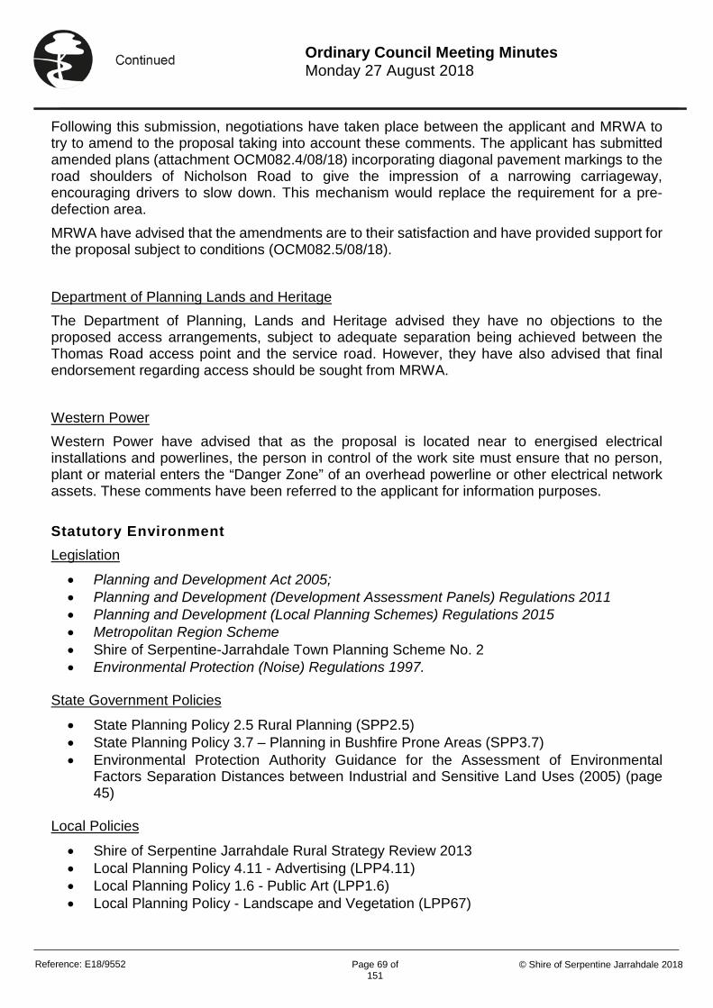
Reference: E18/9552 Page 69 of
151 © Shire of Serpentine Jarrahdale 2018
Ordinary Council Meeting Minutes Monday 27 August 2018
Following this submission, negotiations have taken place between the applicant and MRWA to try to amend to the proposal taking into account these comments. The applicant has submitted amended plans (attachment OCM082.4/08/18) incorporating diagonal pavement markings to the road shoulders of Nicholson Road to give the impression of a narrowing carriageway, encouraging drivers to slow down. This mechanism would replace the requirement for a pre-defection area. MRWA have advised that the amendments are to their satisfaction and have provided support for the proposal subject to conditions (OCM082.5/08/18). Department of Planning Lands and Heritage The Department of Planning, Lands and Heritage advised they have no objections to the proposed access arrangements, subject to adequate separation being achieved between the Thomas Road access point and the service road. However, they have also advised that final endorsement regarding access should be sought from MRWA. Western Power Western Power have advised that as the proposal is located near to energised electrical installations and powerlines, the person in control of the work site must ensure that no person, plant or material enters the “Danger Zone” of an overhead powerline or other electrical network assets. These comments have been referred to the applicant for information purposes. Statutory Environment Legislation
• Planning and Development Act 2005; • Planning and Development (Development Assessment Panels) Regulations 2011 • Planning and Development (Local Planning Schemes) Regulations 2015 • Metropolitan Region Scheme • Shire of Serpentine-Jarrahdale Town Planning Scheme No. 2 • Environmental Protection (Noise) Regulations 1997.
State Government Policies
• State Planning Policy 2.5 Rural Planning (SPP2.5) • State Planning Policy 3.7 – Planning in Bushfire Prone Areas (SPP3.7) • Environmental Protection Authority Guidance for the Assessment of Environmental
Factors Separation Distances between Industrial and Sensitive Land Uses (2005) (page 45)
Local Policies
• Shire of Serpentine Jarrahdale Rural Strategy Review 2013 • Local Planning Policy 4.11 - Advertising (LPP4.11) • Local Planning Policy 1.6 - Public Art (LPP1.6) • Local Planning Policy - Landscape and Vegetation (LPP67)

Reference: E18/9552 Page 70 of
151 © Shire of Serpentine Jarrahdale 2018
Ordinary Council Meeting Minutes Monday 27 August 2018
Planning Assessment A full assessment has been carried out against the current planning framework as part of the RAR which can be viewed in attachment OCM082.1/08/18 and the Clause 67 Checklist (attachment OCM082.6/08/18). For the purposes of this report, matters of concern or where variations are sought will be discussed. Land Use:
In considering the land use of the proposal, Officers have considered the land uses of ‘Service Station’ and ‘Convenience Store’ defined under TPS2 as follows”- ‘Service Station’ “means land and buildings used for the supply of petroleum products and motor vehicle accessories and for carrying out greasing, tyre repairs and minor mechanical repairs and may include a cafeteria, restaurant or shop incidental to the primary use; but does not include transport depot, panel beating, spray painting, major repairs or wrecking”.
The proposal seeks approval for the sale of petroleum products and includes a shop. The proposal could therefore reasonably be considered to fall within the land use of ‘Service Station’ although it does not include the carrying out of greasing, tyre repairs or minor mechanical repairs. ‘Convenience Store’ “means land and buildings used for the retail sale of convenience goods being those goods commonly sold in supermarkets, delicatessens and newsagents but including the sale of petrol and operated during hours which include but which may extend beyond normal trading hours and providing associated parking. The buildings associated with a convenience store shall not exceed 300 square metres gross leasable area”.
The proposal could also reasonably fall within the definition of ‘Convenience Store’ as it includes the retail sale of convenience goods and petrol. This definition also includes operating hours outside of normal trading hours. ‘Building’ is defined under TPS2 as having “the same meaning as is given to it in and for the purposes of the Residential Planning Codes’ which includes any structure. Therefore, as the buildings associated with the use, including the areas under the canopies, exceed 300 square metres gross leasable area, it is considered that the proposal is excluded from this definition and therefore best fits within the land use of ‘Service Station’. Form of Development The proposed retail building is located centrally to the site and orientated with the entrance and primary frontage to Thomas Road. The materials are of earthy tones with the use of cladding and face brick panelling. It is considered that the use of colours and materials reflect the rural character of the area. The light vehicle bowsers are located to the south of the retail building fronting Thomas Road with the heavy vehicle bowsers towards the rear of the lot. The plant and service yards are located behind the buildings, which does not adversely impact on the rural character of the streetscape. The proposal includes landscaping along the boundaries of the subject site and building. The landscaping is focussed within Lot 12 where the buildings and structures are proposed. Comments were received from the Shire’s Environmental Officers who raised concerns in relation to the adequacy of the landscaping and that it does not fully replace the trees that would be lost as part of the development. Officers consider that a condition requiring an amended landscaping plan would allow further landscaping measures to address these concerns.
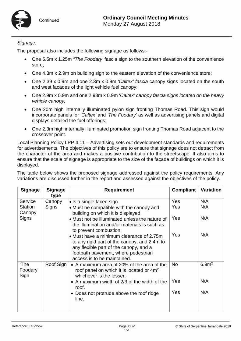
Reference: E18/9552 Page 71 of
151 © Shire of Serpentine Jarrahdale 2018
Ordinary Council Meeting Minutes Monday 27 August 2018
Signage:
The proposal also includes the following signage as follows:-
• One 5.5m x 1.25m “The Foodary’ fascia sign to the southern elevation of the convenience store;
• One 4.3m x 2.9m on building sign to the eastern elevation of the convenience store;
• One 2.39 x 0.9m and one 2.3m x 0.9m ‘Caltex’ fascia canopy signs located on the south and west facades of the light vehicle fuel canopy;
• One 2.9m x 0.9m and one 2.93m x 0.9m ‘Caltex’ canopy fascia signs located on the heavy vehicle canopy;
• One 20m high internally illuminated pylon sign fronting Thomas Road. This sign would incorporate panels for ‘Caltex’ and ‘The Foodary’ as well as advertising panels and digital displays detailed the fuel offerings;
• One 2.3m high internally illuminated promotion sign fronting Thomas Road adjacent to the crossover point.
Local Planning Policy LPP 4.11 – Advertising sets out development standards and requirements for advertisements. The objectives of this policy are to ensure that signage does not detract from the character of the area and makes a positive contribution to the streetscape. It also aims to ensure that the scale of signage is appropriate to the size of the façade of buildings on which it is displayed. The table below shows the proposed signage addressed against the policy requirements. Any variations are discussed further in the report and assessed against the objectives of the policy.
Signage Signage type
Requirement Compliant Variation
Service Station Canopy Signs
Canopy Signs
• Is a single faced sign. • Must be compatible with the canopy and
building on which it is displayed. • Must not be illuminated unless the nature of
the illumination and/or materials is such as to prevent combustion.
• Must have a minimum clearance of 2.75m to any rigid part of the canopy, and 2.4m to any flexible part of the canopy, and a footpath pavement, where pedestrian access is to be maintained.
Yes Yes Yes Yes
N/A N/A N/A N/A
‘The Foodary’ Sign
Roof Sign • A maximum area of 20% of the area of the roof panel on which it is located or 4m2 whichever is the lesser.
• A maximum width of 2/3 of the width of the roof.
• Does not protrude above the roof ridge line.
No Yes Yes
6.9m2 N/A N/A
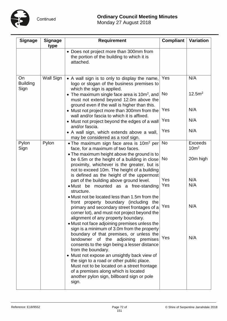
Reference: E18/9552 Page 72 of
151 © Shire of Serpentine Jarrahdale 2018
Ordinary Council Meeting Minutes Monday 27 August 2018
Signage Signage type
Requirement Compliant Variation
• Does not project more than 300mm from the portion of the building to which it is attached.
On Building Sign
Wall Sign • A wall sign is to only to display the name, logo or slogan of the business premises to which the sign is applied.
• The maximum single face area is 10m2, and must not extend beyond 12.0m above the ground even if the wall is higher than this.
• Must not project more than 300mm from the wall and/or fascia to which it is affixed.
• Must not project beyond the edges of a wall and/or fascia.
• A wall sign, which extends above a wall, may be considered as a roof sign.
Yes No Yes Yes Yes
N/A 12.5m2
N/A
N/A N/A
Pylon Sign
Pylon • The maximum sign face area is 10m2 per face, for a maximum of two faces.
• The maximum height above the ground is to be 6.5m or the height of a building in close proximity, whichever is the greater, but is not to exceed 10m. The height of a building is defined as the height of the uppermost part of the building above ground level.
• Must be mounted as a free-standing structure.
• Must not be located less than 1.5m from the front property boundary (including the primary and secondary street frontages of a corner lot), and must not project beyond the alignment of any property boundary.
• Must not face adjoining premises unless the sign is a minimum of 3.0m from the property boundary of that premises, or unless the landowner of the adjoining premises consents to the sign being a lesser distance from the boundary.
• Must not expose an unsightly back view of the sign to a road or other public place. Must not to be located on a street frontage of a premises along which is located another pylon sign, billboard sign or pole sign.
No No Yes Yes Yes Yes
Exceeds 10m2
20m high
N/A N/A N/A N/A

Reference: E18/9552 Page 73 of
151 © Shire of Serpentine Jarrahdale 2018
Ordinary Council Meeting Minutes Monday 27 August 2018
Variations:
The Foodary Sign This sign is proposed to have an area of 6.9m2 in lieu of the policy requirement of 4m2. The applicant has provided a justification to the variation and stated that this sign functions as a point of identification for the entrance. It is the only sign on the front of the building and proportionally reflects the scale of the building and the architectural design. Officers consider that as the signage comprises of white coloured individual letters, it would not appear intrusive or excessive. It is considered that in this instance the sign would not dominate the elevation of the building due to its scale or have an adverse impact on the character of the area. As such, the proposed sign is considered consistent with the objectives of the policy and the variation is supported by Officers. On Building Sign The on building sign is proposed to be 12.5m2 in lieu of 10m2 as per the policy requirement. As with the ‘Foodary’ sign, Officers consider that the scale of the sign is consistent with the scale of the building and as such would not appear intrusive or excessive. Officers consider this signage is consistent with objectives of the policy and would not adversely impact on the character of the area. Pylon Sign The application seeks approval for a 20m high pylon sign, each face of the sign exceeding 10m2
in area. This is significantly higher than what is acceptable under LPP 4.11. The applicant has provided justification that the sign is required to provide early identification of the site and that existing vegetation would impact its visibility if it were smaller. The applicant also notes that the proposal does not impact on sightlines from the intersection or the crossovers. Additional information has been provided to further justify their position in the form of photomontages, contained within attachment OCM082.7/08/18. Officers acknowledge that Thomas Road is a Primary Regional road, however the streetscape maintains the areas rural character. The addition of signage of such a significant scale is considered to be an incongruous addition to the rural streetscape. Officers consider that the scale of the pylon sign would adversely impact on the rural character and amenity of the area. It is acknowledged that early identification is considered important however, 20m is a significant variation that is not supported by Officers. LPP4.11 allows for 6.5m high pylon signs or the same height as a building in close proximity. It is considered that the justification requiring early identification does not outweigh the need to maintain the rural character of the area. A 20m high pylon sign would be 13.5m higher than the canopy for the truck fuelling. It is considered that the height of this sign would appear inconsistent with the scale of the development on the site and the surrounding area. Due to the location of the sign, it would appear visually intrusive within the streetscape and adversely impact on the rural character of the area. Officers propose a condition to ensure that the pylon sign is reduced significantly in height.

Reference: E18/9552 Page 74 of
151 © Shire of Serpentine Jarrahdale 2018
Ordinary Council Meeting Minutes Monday 27 August 2018
Traffic, Access and Safety Thomas Road is identified as a Primary Regional Road and designated freight route. Nicholson Road is identified as an Other Regional Road. Both of these classes of roads are designed to carry larger volumes of traffic. Access and egress to the site is proposed to be taken from both Thomas Road and Nicolson Road. Access from Thomas Road is to be left in for both light and heavy vehicles and left out for light vehicles only. All heavy vehicles would be required to ingress via Thomas Road. The access from Nicholson Road will be left-in for light vehicles only and left-out for light and heavy vehicles. The applicant states that the site has been designed to accommodate access and parking for heavy vehicles up to 36.5m B-double standard. Concerns were raised during the advertising period relating to the potential safety and access issues resulting from the potential increased traffic on Thomas Road and the capability of the existing network infrastructure to accommodate increased traffic volumes. A Transport Impact Assessment has been submitted as part of the application. This shows that the majority of trade would be from existing passing traffic through Thomas and Nicholson Road. The assessment findings conclude that the proposal is estimated to result in an additional 16 and 22 trips during the AM and PM peak periods respectively. It is noted that currently the intersection suffers from capacity shortages during peak periods, however once upgraded as proposed, there will be adequate capacity. The applicant has acknowledged that the Thomas Road and Nicolson Road intersection is subject to a future upgrade. Consultation has been undertaken with MRWA to ensure the upgrades would not prevent or prejudice the access arrangements for the proposal. The proposal has been designed to accommodate the future upgrades to the Thomas Road and Nicholson Road intersection and a concept plan has been provided for what potentially will be the ultimate access arrangements and for the interim arrangements. Although the future plans are not yet in place it is envisaged that a two lane roundabout will be constructed at the intersection. Initially, concerns were raised by MRWA in relation to the ultimate access arrangements due to the crossover on Nicolson Road located within the pre-deflection area of the future roundabout. Subsequently, further discussions have been undertaken with MRWA and the access arrangements have been amended accordingly, to the satisfaction of MRWA. The access arrangements are proposed to be over three phases (attachment OCM082.4/08/18). Phase 1 is based on the current configuration prior to any road upgrades. It involves provision of a left-in slip lane for the Nicholson Road access and a left-in slip lane for the access on Thomas Road to ensure all vehicles are able to safely manoeuvre into the subject site without impacting the movements of traffic along Thomas and Nicolson Road. Median islands are also included opposite both crossovers to prevent right-turn traffic movements. There would be small paved islands in the centre of both crossovers to delineate the flow of traffic. In addition, a signage strategy and road markings are proposed to ensure safe and correct movement of all vehicles. Phase 2 consists of an interim roundabout estimated to be completed by MRWA within 12-18 months. To maintain a safe approach to the intersection following construction of the roundabout, Nicholson Road would incorporate diagonal pavement markings to the road shoulders to give the impression of a narrowing carriageway, encouraging drivers to slow down. This is the proposed alternative to a pre-deflection area satisfying the initial concerns of MRWA. Phase 2 is provided as a concept only to demonstrate that safe access to the subject site can be maintained following road upgrades. The detailed design and construction of the roundabouts will

Reference: E18/9552 Page 75 of
151 © Shire of Serpentine Jarrahdale 2018
Ordinary Council Meeting Minutes Monday 27 August 2018
be the responsibility of MRWA. Modifications to the access and egress of the proposal are not required to facilitate the Phase 2 interim roundabout upgrades. Phase 3 provides an ultimate arrangement for the long term plans for the road network. This is anticipated to be carried out during the next 15 to 20 years. This ultimate scenario is therefore a long term consideration which is understood to still be undergoing design and funding arrangements. It is considered that the applicant has demonstrated the proposal would not adversely impact on traffic safety and MRWA have confirmed that their initial concerns have been addressed. Amenity The proposal would operate 24 hours per day, seven days a week. Due to the existing traffic volumes on both Nicolson and Thomas Road, it is considered that the proposal would not adversely impact on adjoining landowners by way of traffic noise due to the additional traffic numbers provided within the Transport Assessment. It is acknowledged that additional noise would be resultant from the operations of the facility. The EPA Guidelines require a separation distance of 100m between service stations and sensitive receptors. In this case, the proposal is compliant with this requirement. Furthermore, the EPA Guidelines set this standard for service stations that include vehicle cleaning/detailing which are not proposed as part of this application and are considered to result in more noise than what is being applied for in this case. This 100m separation distance is also required for freeway service centres which also operate 24hrs. To satisfy any noise sources from the running of the business and to mitigate the impact on adjoining residents, Officers recommended a condition requiring a Noise Assessment/Management Plan to identify any additional sources of noise and provide details of how these would be managed. This goes further to ensure that an acceptable level of residential amenity is maintained. One of the concerns raised during the advertising period related to light spill. A lighting plan would also be required as a condition to ensure any lighting would not adversely impact on the amenity of neighbouring properties. Landscaping is a significant contribution towards the amenity of rural areas. LPP67 sets out requirements for landscaping and vegetation and its objective is to “Contribute towards achievement of vegetation and landscape outcomes that meet the expectations of stakeholders and contribute towards the achievement of biodiversity and water use targets and the creation of vibrant places for our communities”. The applicant has provided information that landscaping will be undertaken to offset the loss of trees from the site. A condition is be recommended to require an amended detailed landscaping plan to be prepared and approved by the Shire prior to commencement of works. The landscaping plan will be required to be in accordance with LPP67 and further compensate for the vegetation that would be lost as part of the development.

Reference: E18/9552 Page 76 of
151 © Shire of Serpentine Jarrahdale 2018
Ordinary Council Meeting Minutes Monday 27 August 2018
Options and Implications Option 1: That Council endorse the Responsible Authority Report contained within the attachments, which recommends that the Metropolitan East Joint Assessment Panel approve the application for proposed ‘Service Station’ at Lot 12, 1537 Thomas Road and Lot 50 Nicholson Road, Oakford. Option 2: That Council does not endorse the Responsible Authority Report contained within the attachments, which recommends that the Metropolitan East Joint Assessment Panel approve the application for ‘Service Station’ at Lot 12, 1537 Thomas Road and Lot 50 Nicholson Road, Oakford. Option 1 is recommended. Conclusion The application seeks approval for a ‘Service Station’. The proposal would be located on the corner of a Primary Regional Road and an Other Regional Road providing goods and petroleum for passing traffic. The proposal would also provide for a retail service for residents of the local area. The application is considered consistent with the planning framework and the principles of orderly and proper planning. The applicant has demonstrated that the future access arrangements will not prejudice the future planned road upgrades. The proposal is therefore recommended for approval by Officers. Attachments
• OCM082.1/08/18 – Responsible Authority Report (E18/8772) • OCM082.2/08/18 – Initial Application Details (E18/8084) • OCM082.3/08/18 – Summary of Submissions (E18/3713) • OCM082.4/08/18 – Amended Access Arrangements (E18/8099) • OCM082.5/08/18 – MRWA Letter of Support (E18/8805) • OCM082.6/08/18 – Clause 67 Checklist (E18/7964) • OCM082.7/08/18 - Photomontages (E18/8083) • OCM082.8/08/18 – Application Details for Approval (E18/8146)
Alignment with our Strategic Community Plan
Outcome 3.1 A commercially diverse and prosperous economy Strategy 3.1.1 Actively support new and existing local business within the district.
Financial Implications Nil

Reference: E18/9552 Page 77 of
151 © Shire of Serpentine Jarrahdale 2018
Ordinary Council Meeting Minutes Monday 27 August 2018
Risk Implications Risk has been assessed on the basis of the Officer’s Recommendation.
Risk
Risk Likelihood (based on history and with existing controls)
Risk Impact / Consequence
Risk Rating (Prior to Treatment or Control)
Principal Risk Theme
Risk Action Plan (Controls or Treatment proposed)
Council not endorsing the RAR
Possible (3) Moderate (3) Moderate (5-9)
Financial Impact - 1 Insignificant - Less than $50,000
Accept Officer Recommendation
Risk Matrix
A risk is often specified in terms of an event or circumstance and the consequences that may flow from it. An effect may be positive, negative or a deviation from the expected and may be related to the following objectives; occupational health and safety, financial, service interruption, compliance, reputation and environment. A risk matrix has been prepared and a risk rating of 9 has been determined for this item. Any items with a risk rating over 10 (considered to be high or extreme risk) will be added to the Risk Register, and any item with a risk rating over 17 will require a specific risk treatment plan to be developed.
Reference: E18/9552 Page 78 of
151 © Shire of Serpentine Jarrahdale 2018
Ordinary Council Meeting Minutes Monday 27 August 2018
Voting Requirements: Simple Majority OCM082/08/18 Officer Recommendation: 1. That Council endorses the Responsible Authority Report contained within attachment
OCM082.1/08/18 which recommends that the Metropolitan East Joint Development Assessment Panel approve the ‘Service Station’ Lot 12, 1537 Thomas Road and Lot 50 Nicholson Road, Oakford as contained within attachment OCM082.8/08/18 subject to the following conditions:-
a. The development is to be carried out in compliance with the plans and documentation listed below and endorsed with the Shire of Serpentine Jarrahdale stamp, except where amended by other conditions of this consent.
• Plans and Specifications
• P1 – P22 received at the Shire Offices on 28 March 2018 and 24 July 2018 and Bushfire Management Plan and Risk Management Plans dated 19 March 2018
b. Prior to commencement of works, a landscaping/revegetation plan shall be submitted to and approved by the Shire of Serpentine Jarrahdale. Within 60 days of commencement, the approved landscaping/revegetation plan shall be implemented and maintained thereafter.
c. Prior to commencement of works, a detailed Stormwater Plan shall be submitted to and approved by the Shire of Serpentine Jarrahdale. The approved Stormwater Plan shall be implemented and maintained thereafter.
d. Prior to the commencement of works, a Construction Management Plan shall be submitted to and approved by the Shire of Serpentine Jarrahdale. The Construction Management Plan shall include but not be limited to the following information:- i) Dust management ii) Traffic management These approved plans shall be implemented and maintained throughout the construction of the development.
e. Prior to occupation, a lighting plan shall be submitted to and approved by the Shire of Serpentine Jarrahdale. The approved lighting plan shall be implemented and maintained thereafter.
f. Prior to occupation, an agreed monetary contribution shall be paid to the Shire of Serpentine Jarrahdale for the establishment of public art in accordance with Council's Local Planning Policy 1.6 - Public Art to the satisfaction of the Shire of Serpentine Jarrahdale.
g. The pylon sign shall be no higher than 7m unless otherwise approved by the Shire of Serpentine Jarrahdale.
h. Prior to Commencement of works, a Noise Assessment and Management Plan shall be submitted to and approved by the Shire of Serpentine Jarrahdale. Once approved, the plans shall be implemented and maintained thereafter.

Reference: E18/9552 Page 79 of
151 © Shire of Serpentine Jarrahdale 2018
Ordinary Council Meeting Minutes Monday 27 August 2018
i. One 11 metre wide crossover located within Lot 50, Nicholson Road, Oakford and positioned where possible near the northern most cadastral boundary of Lot 50. This requirement is to protect the functional area of this intersection in accordance with Austroads 2017 Guide to Road Design Part 4 Intersections and Crossings General, section 7 .2 Property Access. This access shall operate as left in/left out turning movements for light vehicles and left out only turning movements for heavy vehicles and shall have suitable signage advising motorists of these restricted movements. The developer shall be responsible for all costs involved in the land acquisition, design and construction of the left turning pocket and solid median to prevent right out turning movements onto Nicholson Road. This includes signing, road markings, relocation of services, street lighting and Main Roads costs involved in the checking of the design and construction drawings and any site inspections Thomas Road
j. One 11 metre wide crossover located within Lot 12 Thomas Road, Oakford and positioned where possible near the easternmost cadastral boundary of Lot 12. This requirement is to protect the functional area of this intersection in accordance with Austroads 2017 Guide to Road Design Part 4 Intersections and Crossings General, section 7.2 Property Access. This access shall operate as left in/left out turning movements for light vehicles and left in only turning movements for heavy vehicles and shall have suitable signage advising motorists of these restricted movements. The developer shall be responsible for all costs involved in the land acquisition, design and construction of the left turning pocket and solid median to prevent right out movements onto Thomas Road. This includes signing, road markings, relocation of services, street lighting and Main Roads costs involved in the checking of the design and construction drawings and any site inspections
k. Any services, infrastructure or roadside furniture that requires relocation as a result of the applicant's works will be at the applicant's cost.
l. Lot 50 is affected by land reserved in the Metropolitan Region Scheme for "Other Regional Road" and no development will be permitted within this land required for road purposes at some time in the future. The applicant is advised to contact the Department Planning, Lands & Heritage - Infrastructure Land Use Co-Ordinating Branch (ILUC) for further details in this regard.
m. No earthworks shall encroach onto the Nicholson and Thomas Road road reserve. n. No stormwater drainage shall be discharged onto the Nicholson and Thomas Road
road reserve. o. The applicant shall make good any damage to the existing verge vegetation within the
Nicholson and Thomas Road road reserve. p. The applicant must obtain approval from Main Roads before all works are undertaken
within the Thomas Road reserve. The applicant seeking access to the Main Roads network will be required to submit an Application as outlined in the "Application Kit and Guidelines" for State Roads.

Reference: E18/9552 Page 80 of
151 © Shire of Serpentine Jarrahdale 2018
Ordinary Council Meeting Minutes Monday 27 August 2018
Application Kits can be found on the Main Roads website >"Our Roads" >"Conducting Works on Roads >"Applications to Undertake Works on State Roads" >Application Kit and Guidelines for Complex Works OR Application Form for Low Complexity Works.
q. The type of sign, size, content and location must comply with all relevant by-laws and planning schemes made by Council.
r. The sign and sign structure is to be placed on private property and shall not over hang or encroach upon the road reserve.
s. As the signage is illuminated, it must be of a low-level not exceeding 300cdi"'2, not flash, pulsate or chase
t. The device shall not contain fluorescent, reflective or retro reflective colours or materials.
u. No other unauthorized signing is to be displayed v. Main Roads agreement is to be obtained prior to any future modifications. w. Vegetation within the state road reserve shall not be removed or trimmed to improve
the visibility of the proposed advertising sign. Advice Notes 1. As you are aware, this intersection is recognised as a dangerous black spot and has received
funding from the Road Trauma Fund account to undertake preliminary planning design concepts. At this point in time, the traffic modelling depicts that the preferred intersection treatment at this location is a roundabout treatment, for both interim and ultimate stage. The applicant is reminded that upon the roundabout being constructed to its ultimate configuration, the existing access on Nicholson Road will be removed and all access into the petrol station development will be achieved via a dedicated service road accessed from the north of Lot 50. Please be aware that the timing of the construction of the roundabout {both interim and ultimate stages) including the preferred type of intersection treatment for this intersection is subject to change and that Main Roads assumes no liability whatsoever for the information provided.
2. An internal 15% design review has been undertaken for the submitted drawings for this development proposal. The attached design review comments are not to be considered a comprehensive design verification and may not pick-up all the issues. Therefore it is not an approval of the presented design.
Reference: E18/9552 Page 81 of
151 © Shire of Serpentine Jarrahdale 2018
Ordinary Council Meeting Minutes Monday 27 August 2018
OCM082/08/18 COUNCIL RESOLUTION Moved Cr Byas, seconded Cr Denholm 1. That Council endorses the Responsible Authority Report contained within attachment
OCM082.1/08/18 which recommends that the Metropolitan East Joint Development Assessment Panel approve the ‘Service Station’ Lot 12, 1537 Thomas Road and Lot 50 Nicholson Road, Oakford as contained within attachment OCM082.8/08/18 subject to the following conditions:-
a. The development is to be carried out in compliance with the plans and
documentation listed below and endorsed with the Shire of Serpentine Jarrahdale stamp, except where amended by other conditions of this consent.
• Plans and Specifications • P1 – P22 received at the Shire Offices on 28 March
2018 and 24 July 2018 and Bushfire Management Plan and Risk Management Plans dated 19 March 2018
b. Prior to commencement of works, a landscaping/revegetation plan shall be
submitted to and approved by the Shire of Serpentine Jarrahdale. Within 60 days of commencement, the approved landscaping/revegetation plan shall be implemented and maintained thereafter.
c. Prior to commencement of works, a detailed Stormwater Plan shall be submitted
to and approved by the Shire of Serpentine Jarrahdale. The approved Stormwater Plan shall be implemented and maintained thereafter.
d. Prior to the commencement of works, a Construction Management Plan shall be
submitted to and approved by the Shire of Serpentine Jarrahdale. The Construction Management Plan shall include but not be limited to the following information:- i) Dust management ii) Traffic management
These approved plans shall be implemented and maintained throughout the construction of the development.
e. Prior to occupation, a lighting plan shall be submitted to and approved by the
Shire of Serpentine Jarrahdale. The approved lighting plan shall be implemented and maintained thereafter.
f. Prior to occupation, an agreed monetary contribution shall be paid to the Shire
of Serpentine Jarrahdale for the establishment of public art in accordance with Council's Local Planning Policy 1.6 - Public Art to the satisfaction of the Shire of Serpentine Jarrahdale.
g. The pylon sign shall be no higher than 7m unless otherwise approved by the
Shire of Serpentine Jarrahdale.

Reference: E18/9552 Page 82 of
151 © Shire of Serpentine Jarrahdale 2018
Ordinary Council Meeting Minutes Monday 27 August 2018
h. Prior to Commencement of works, a Noise Assessment and Management Plan
shall be submitted to and approved by the Shire of Serpentine Jarrahdale. Once approved, the plans shall be implemented and maintained thereafter.
i. One 11 metre wide crossover located within Lot 50, Nicholson Road, Oakford
and positioned where possible near the northern most cadastral boundary of Lot 50. This requirement is to protect the functional area of this intersection in accordance with Austroads 2017 Guide to Road Design Part 4 Intersections and Crossings General, section 7 .2 Property Access.
This access shall operate as left in/left out turning movements for light vehicles and left out only turning movements for heavy vehicles and shall have suitable signage advising motorists of these restricted movements. The developer shall be responsible for all costs involved in the land acquisition, design and construction of the left turning pocket and solid median to prevent right out turning movements onto Nicholson Road. This includes signing, road markings, relocation of services, street lighting and Main Roads costs involved in the checking of the design and construction drawings and any site inspections Thomas Road
j. One 11 metre wide crossover located within Lot 12 Thomas Road, Oakford and
positioned where possible near the easternmost cadastral boundary of Lot 12. This requirement is to protect the functional area of this intersection in accordance with Austroads 2017 Guide to Road Design Part 4 Intersections and Crossings General, section 7.2 Property Access.
This access shall operate as left in/left out turning movements for light vehicles and left in only turning movements for heavy vehicles and shall have suitable signage advising motorists of these restricted movements. The developer shall be responsible for all costs involved in the land acquisition, design and construction of the left turning pocket and solid median to prevent right out movements onto Thomas Road. This includes signing, road markings, relocation of services, street lighting and Main Roads costs involved in the checking of the design and construction drawings and any site inspections
k. Any services, infrastructure or roadside furniture that requires relocation as a
result of the applicant's works will be at the applicant's cost. l. Lot 50 is affected by land reserved in the Metropolitan Region Scheme for "Other
Regional Road" and no development will be permitted within this land required for road purposes at some time in the future.
The applicant is advised to contact the Department Planning, Lands & Heritage - Infrastructure Land Use Co-Ordinating Branch (ILUC) for further details in this regard.

Reference: E18/9552 Page 83 of
151 © Shire of Serpentine Jarrahdale 2018
Ordinary Council Meeting Minutes Monday 27 August 2018
m. No earthworks shall encroach onto the Nicholson and Thomas Road road reserve.
n. No stormwater drainage shall be discharged onto the Nicholson and Thomas
Road road reserve. o. The applicant shall make good any damage to the existing verge vegetation
within the Nicholson and Thomas Road road reserve. p. The applicant must obtain approval from Main Roads before all works are
undertaken within the Thomas Road reserve. The applicant seeking access to the Main Roads network will be required to submit an Application as outlined in the "Application Kit and Guidelines" for State Roads.
Application Kits can be found on the Main Roads website >"Our Roads" >"Conducting Works on Roads >"Applications to Undertake Works on State Roads" >Application Kit and Guidelines for Complex Works OR Application Form for Low Complexity Works.
q. The type of sign, size, content and location must comply with all relevant by-
laws and planning schemes made by Council. r. The sign and sign structure is to be placed on private property and shall not over
hang or encroach upon the road reserve. s. As the signage is illuminated, it must be of a low-level not exceeding 300cdi"'2,
not flash, pulsate or chase t. The device shall not contain fluorescent, reflective or retro reflective colours or
materials. u. No other unauthorized signing is to be displayed v. Main Roads agreement is to be obtained prior to any future modifications. w. Vegetation within the state road reserve shall not be removed or trimmed to
improve the visibility of the proposed advertising sign. x. The service station is not to be operational before the Main Roads Roundabout is
constructed. Advice Notes 1. As you are aware, this intersection is recognised as a dangerous black spot and has
received funding from the Road Trauma Fund account to undertake preliminary planning design concepts. At this point in time, the traffic modelling depicts that the preferred intersection treatment at this location is a roundabout treatment, for both interim and ultimate stage.
Reference: E18/9552 Page 84 of
151 © Shire of Serpentine Jarrahdale 2018
Ordinary Council Meeting Minutes Monday 27 August 2018
The applicant is reminded that upon the roundabout being constructed to its ultimate configuration, the existing access on Nicholson Road will be removed and all access into the petrol station development will be achieved via a dedicated service road accessed from the north of Lot 50. Please be aware that the timing of the construction of the roundabout {both interim and ultimate stages) including the preferred type of intersection treatment for this intersection is subject to change and that Main Roads assumes no liability whatsoever for the information provided.
2. An internal 15% design review has been undertaken for the submitted drawings for this development proposal. The attached design review comments are not to be considered a comprehensive design verification and may not pick-up all the issues. Therefore it is not an approval of the presented design.
CARRIED 5/1 Councillor Byas, in accordance with Section 5.21(4)(b), Local Government Act 1995
requested the votes be recorded. Councillors Byas, Denholm, McConkey, Rich and See voted FOR the motion.
Councillor Coales voted AGAINST the motion. Reason for difference to Officers Recommendation Condition x. was added to ensure JDAP considers the safety of the intersection.


![The Doors - Roadhouse Blues [Piano Sheet Music]](https://img.pdfslide.us/doc/110x75/55cf94a7550346f57ba3803a/the-doors-roadhouse-blues-piano-sheet-music-561aaebaa5b32.jpg)