Embed Size (px)
Citation preview
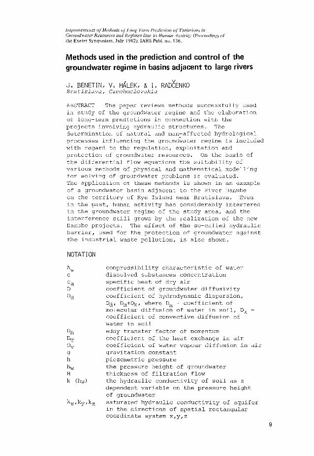
Improvements of Methods of Long Term Prediction of Variations in Groundwater Resources and Regimes Due to Human Activity (Proceedings of the Exeter Symposium, July 1982). IAHS Publ. no. 136.
Methods used in the prediction and control of the groundwater regime in basins adjacent to large rivers
J, BENETIN/ V, HALEK, & I, RADCENKO Bratislava, Czechoslovakia
ABSTRACT The paper reviews methods successfully used in study of the groundwater regime and the elaboration of long-term predictions in connection with the projects involving hydraulic structures. The determination of natural and man-affected hydrological processes influencing the groundwater regime is included with regard to the regulation, exploitation and protection of groundwater resources. On the basis of the differential flow equations the suitability of various methods of physical and mathematical modelling for solving of groundwater problems is evaluated. The application of these methods is shown in an example of a groundwater basin adjacent to the River Danube on the territory of Rye Island near Bratislava. Even in the past, human activity has considerably interfered in the groundwater regime of the study area, and the interference still grows by the realization of the new Danube projects. The effect of the so-called hydraulic barrier, used for the protection of groundwater against the industrial waste pollution, is also shown.
NOTATION
^w c ca D Dd
D T
Dv
g h h w
H k (hw)
kx'ky'kz
9
compressibility characteristic of water dissolved substances concentration specific heat of dry air coefficient of groundwater diffusivity coefficient of hydrodynamic dispersion, Dd' Dm + Dk' where Dm - coefficient of molecular diffusion of water in soil, D̂ . -coefficient of convective diffusion of water in soil eddy transfer factor of momentum coefficient of the heat exchange in air coefficient of water vapour diffusion in air gravitation constant piezometric pressure the pressure height of groundwater thickness of filtration flow the hydraulic conductivity of soil as a dependent variable on the pressure height of groundwater saturated hydraulic conductivity of aquifer in the directions of spatial rectangular coordinate system x,y,z

10 J.Benetin et al.
N the substances exchanged between the solid and liquid phase of soil or aquifer
qe water vapour flow from the evaporating surface
s course of movement t time u v wind velocity uv,x, uv,y, u v, z - components
of wind velocity in the direction x,y,z T air temperature near to the evaporating
surface vQ infiltration velocity (+) or the velocity
evaporation (respectively the velocity of capillary rise from the groundwater)
ve£ evapo-transpiration velocity vx,vy,vz the motion velocity of water in soil or in
aquifer in the directions of spatial rectangular coordinate system
z height above the soil surface soil moisture in volume parts specific yield, free porosity in the volume parts of aquifer compressibility characteristic of aquifer density of air density of water vapour in atmospheric air transfer of momentum in the flowing air Laplacian
INTRODUCTION
The large groundwater basins adjacent to rivers are regions of special interests in the national economy and other human activities, for in them are found the main chemical, engineering and food industries, agriculture, urbanization, transport and other activities. Thirty-five or more years ago the demands for exploitation of alluvial basins adjacent to rivers for water supply as against the problems of groundwater resources protection were not as much in conflict as they are today. Hence interest in groundwater was directed mainly to the reclamation of agriculturally exploitable soils and the regulation of the water table in urban areas. There was no need to use strict measures for protection of the groundwater resources, and different kinds of industrial, agricultural and human pollution escaped attention.
This situation has changed considerably over the past three decades. Development of the national economy and urbanization resulted in high demands for water supply from the alluvial basins, and groundwater became one of the basic sources. The most important problems facing hydrogeologists are those requiring detailed knowledge of the groundwater regime, the influence of human activity on this source of water, and its protection against pollution. Step by step a groundwater observation network was established: the hydrometeorlogical services were supplemented by the observation of all quantitative and qualitative

Groundwater in basins adjacent to large rivers
characteristics with the aim of analysing the dépendance of the groundwater regime on climatic factors and changes of the hydrological conditions (e.g. river discharge, reclaiming activity, etc.). Subsequent research was concentrated on hydrological and hydrogeological methods of analysis of the groundwater regime and methods of determining hydro-physical chacteristics of the aquifers including simulation methods (Hâlek, 1961). For studies of groundwater regime dynamics and its prediction, the mathematical theory of hydromechanics of flow through porous media was applied together with the utilization of efficient computing techniques. Different methods for physical and mathematical modelling were developed to solve the actual problems in complex natural conditions. It may be stated that the theoretical basis and applied methods of groundwater research are up to the present standards of scientific and technological development. Nevertheless, we are facing still more complicated problems as also is the case with surface water research. These problems usually originate more in the determination of the basic dynamic aquifer characteristics for the whole groundwater basin and the description of real natural conditions in mathematical terms, than in the limited possiblities of fully reliable physical and mathematical modelling of the groundwater regime under the influence of hydraulic and other structures. Keeping in mind the above-mentioned limitations, the usual way to produce a reliable prediction of the modified groundwater regime requires a combination of several methods as described in this paper.
THEORETICAL PRINCIPLES
Figure 1 shows a scheme of hydrological modelling of an area adjacent to the river under conditions of percolation or periodic percolation through the soil where the shallow groundwater in dry periods can take part in the evaporation from the soil surface or via evapo-transpiration by means of the capillary rise of water to the root zone. The direct evaporation of groundwater occurs only exceptionally in those cases when the water table rises to the soil surface. In the groundwater basins the depth of alluvial deposits varies from several metres up to several hundreds of metres. The depth of the impermeable subsoils also varies to a considerable extent so that in the large terrain depressions deep groundwater levels are found.
When carrying out an investigiation of the groundwater regime in the alluvial basins and predicting the artificial modifications it is very important to separate shallow from the deeper groundwater. The shallow groundwaters play a relatively active part in the natural water circulation for their dynamic storage increases by infiltration of rainwater through the soil, by inflow of water from higher-lying areas, and by percolation of the river water. The dynamic storage decreases by the outflow to rivers (or to other recipients of surface water) and by capillary rise to the soil surface. The effect of these factors on the deep groundwaters is considerably less. The separation of the shallow and deep ground-

12 J.Benetin e t al.
t EVAPOTRANSPIRATI E T
*Jr®
0 N \ / PRECIPITATION \
"IL J I N T E R C E P T I O N
I ' „„
SURFACE WATER SW 1
TER OFSOIL ROOT Z O N E ~ | _ WSRZ |
WATER OF PERCOLATIVE ZON WPZ
|SHALLOW GROUNDWATER SH 6W
I PC I
DEEP GROUNDWATER D6W
< ^ ^ p - I N P U T
( / C — ouTpu
r—-1 o
A C C U M U L A T I O N S - C A P A C I T I E S
H Y D R O L O G I C A L T R A N S P O R T PROCESSES
FIG.l Scheme of the hydrological model of the saturated and unsaturated zones.
waters is one of the serious problems in analysis and prediction of the groundwater regime because it defines the main feature of the groundwater boundary. The upper boundary of the deep groundwater should be placed where the horizontal part of the flow velocity begins to be considerably dominant. It is difficult to determine this boundary because the velocity of deep groundwater movement is slow and the methods of groundwater tracing are therefore influenced by diffusion phenomena.
Another difficult problem is the determination of representative values for the hydro-physical characteristics of the aquifer. These are mainly saturated and unsaturated hydraulic conductivities,
Groundwater in basins adjacent to large rivers 13
drainable porosity and transmissivity. In the study of chemical matter dissolved in groundwater the former characteristics have to be complemented by the determination of representative values for the hydrodynamic dispersion coefficient. In the case of unsteady conditions the calculation or model simulation of groundwater flow over large areas is complicated by variation in some of the hydro-physical characteristics. Those mainly affected are unsaturated conductivity and transmissivity, and often it is drainable porosity. The replacement of these characteristics by mean values reduces the accuracy and reliability of the results, but good results are given by the simulation method if it is applicable.
One problem in long-term prediction of the groundwater regime in areas adjacent to large rivers is in suitably recording the boundary conditions in time and over a sufficient number of years. As practically independent boundary condition we may consider the surface-water regime. The next condition is the percolation of rainwater through the soil profile alternating with the capillary rise of groundwater to the root zone of the soil as a dependent boundary condition. This is part of the solution of groundwater prediction. The complicated cases of independent boundary conditions can be modelled by the following methods: hydraulic analogy models, e.g. space ballotin models (Halek-Nedoma, 1965), horizontal Hele-Shaw models; and mathematical models based on the solution of differential flow equations by the differential method, by the method of finite elements or probability method (Halek, 1965). The time variation of the dependent boundary conditions (percolation and capillary rise) can be described by mathematical modelling using a submodel of the soil/water regime which includes also the influence of such atmospheric elements as precipitation and evaporation.
The theoretical basis of all computations and models of groundwater regime prediction is the set of basic non-linear, differential flow equations describing the saturated and unsaturated zones and, in the cases when the influence of the atmosphere is included, the equations for the flow of water vapour from the soil surface and vegetation cover into the atmosphere. When the groundwater regime prediction includes aspects of water quality, then it is necessary to include the differential equation expressing the process of hydrodynamic dispersion of dissolved substances into the porous medium.
The Equation (1) shows that general differential equation for groundwater flow expressed in the rectangular coordinate system:
where H and h are functions of variables x,y,z and t. By the preservation of the Dupuit-Forcheimer assumption (k„->- œ or
dh/dz-^0), equation (1) turns into the well-known Boussinesq equation. For cases of groundwater flow in areas with a horizontal non-
permeable stratum then h = H, and equation (1) becomes an equation of the Fourier type. For cases of steady flow it can be transformed,
14 J .Benet in et al.
according to the partials of anizotropy, into a Poisson- or Laplace-type equation.
When describing large aquifers sometimes it is suitable to use the extended Darcy's law in the form of equation (2) (Halek & Svec, 1979):
I as AW at l as '\ where the second member on the right side expresses the retardation component of movement.
The unsteady flow of groundwater without leakage effect in stratified aquifers can be solved using Girinskij potential (Girinskij, 1965). This case for several strata with hydraulic conductivities kj , k^-.-.k. +^, with a free surface in the n+1 stratum so that the stratum marked n is absolutely below the water table, was expressed by Halek (1965) as follows:
^^>-hfe+^+è^/-^Vf)>y^+f-/l2+2"^7/2^'-^'^} (3)
Equation (3) can also be written in the form: n
M-_- kn+/lh^Ti(krki+ dt ^ id xz dy
, 4. , 4-,2 ,1„2
v0(x,y>t)
The non-linear differential equations of general type are the basic theoretical starting point for the solution of water movement through the unsaturated zone of the soil profile:
9.9. _ / k(hw) ,, ) , dk(hw) dt { 9 w dz ei
M ^(JÇMgrrtJtWw) A ^ 3V dt v ' g * ' " " ' V - ~dhw "ai vet (6)
Qf-V(Dgrad*)±— ~-vet (7)
Groundwater in basins adjacent to large rivers 15
Equation (6) shows the potential form and equation (7) the diffusion form of the equation for water flow in the unsatuated zone (Childs, 1969; Benetin, 1970). A partial simplification for the solution of equation (5) is made possible by use of the Wenceslaus potential (Halek & Svec, 1979).
When in the framework of groundwater regime prediction the question of the transport of dissolved substances has to be studied, then the given differential equations for water flow in saturated and unsaturated zones are supplemented by the equation of hydrodynamic dispersion of substances in porous media. Its general form is expressed by equation (8) as follows:
In connection with groundwater regime prediction, the movement of gaseous water depends on evaporation and évapotranspiration (Fig.l).
The theoretical basis of many computation methods for the modelling of evaporation is firstly the equation of water vapour diffusion from the evaporating surface (Fick's law) as in equation (9):
^--fo^Kf, (9)
next, equation (10) for heat transmission:
QT=-/°a cQDTgrads Tv (10)
and the mementum equation:
n I a n dz d u
Equations (9) and (11) combined with the continuity equation for unsteady flow give the next formula as follows:
dt ' dz[ v dzJ ndx V s y U*z dz ' "»

16 J.Benetin et al.
The proper analytical solutions of the given equations are suitable only for the plane-defined flow of specific cases with simple initial and boundary conditions. More possibilities are introduced by the methods already given. The application of these methods for the long-term prediction of groundwater in large regions depends to a great extent on the capacity of the computers used. In this case a substantial improvement is promised by development of the matrix digital computers with the help of which it may be possible to simulate the time development of the elements of the hydrological system for the homogenous discrete areas of a basin together with their mutual interaction.
As regards the basic physical image of groundwater flow under conditions of a modified groundwater regime, most known results are provided by the spatial physical modelling based on hydraulic analogy. Commonly, space ballotin models, though heavy in construction, provide trustworthy results. Such results can be used as basic information for detailed study by electrodynamic analogy with continuous and discrete media, and/or for utilization of the network analyser or even the hybrid computer (Hâlek, 1964).
For mathematical modelling of the modified groundwater regime, it is advantageous to use the model of water regime of the soils as a submodel of the system (Benetin et al, 1975; Eagleson, 1978; Benetin, 1979; Benetin, 1981). The outputs obtained from that submodel (percolation and capillary rise) can be used as the inputs to the complex mathematical model of modified groundwater flow.
RESULTS OF PREDICTION AND CONTROL OF THE GROUNDWATER REGIME IN THE RYE ISLAND BASIN
One of the largest and, from the point view of water economics, most important water basins in Czechoslovakia is Rye Island. Its boundary is formed by the main channel of the Danube as well as by its tributary, the Little Danube. The area of the "island" is about 1620 km and it is mainly of lowland character. Near Bratislava, the Danube flows through a tectonically subsided area (the Danube lowland) which has the character of a fault trough which is now filled up with Neogene and Quaternary sediments. The thickness of the Tertiary sediments is about 5000 m and the Quaternary gravel and sand deposits in the centre of the "island" have a thickness ranging from 350 to 400 metres. Along this "island" the Danube river flows practically on the top of the gravel and sand deposits. From the hydraulic point of view the deposits are very permeable; their hydraulic conductivity being about 0.001 m s and in the most permeable layers can reach as much as 0.008 m s~ . The groundwater of the "island" is mainly recharged from the water of the Danube, though in the middle and lower part of the "island" it is also recharged from precipitation. The groundwater levels in the upper part of Rye Island are about 6 to 10 m below the land surface, while in the middle part of the "island" levels are closer to the surface and in the depressions the reach the surface. The dynamic storage provided by the groundwater in these Quaternary sediments of the "island" is a perfect source of high-quality drinking water.
Groundwater in basins adjacent to large rivers 17
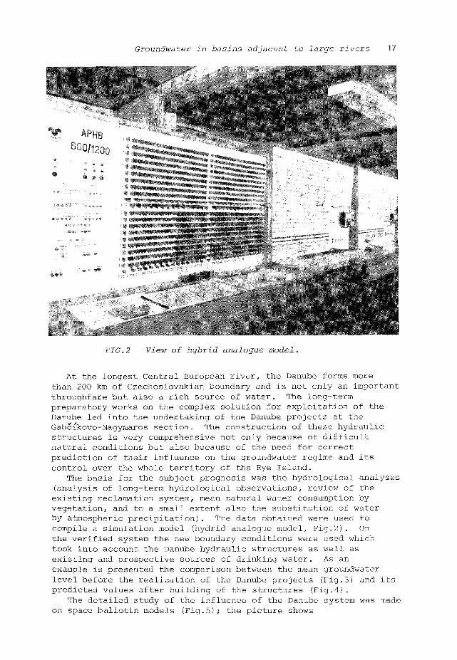
FIG.2 View of hybrid analogue model.
At the longest Central European river, the Danube forms more than 200 km of Czechoslovakian boundary and is not only an important throughfare but also a rich source of water. The long-term preparatory works on the complex solution for exploitation of the Danube led into the undertaking of the Danube projects at the Gabcfkovo-Nagymaros section. The construction of these hydraulic structures is very comprehensive not only because of difficult natural conditions but also because of the need for correct prediction of their influence on the groundwater regime and its control over the whole territory of the Rye Island.
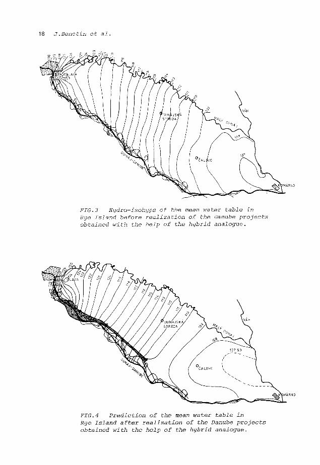
The basis for the subject prognosis was the hydrological analyses (analysis of long-term hydrological observations, review of the existing reclamation system, mean natural water consumption by vegetation, and to a small extent also the substitution of water by atmospheric precipitation). The data obtained were used to compile a on model (hydrid analogue model, Fig.2). On the verified system the new boundary conditions were used which took into account the Danube hydraulic structures as well as existing and prospective sources of drinking water. As an example is presented the comparison between the mean groundwater level before the realization of the Danube projects (Fig.3) and its predicted values after building of the structures (Fig.4).
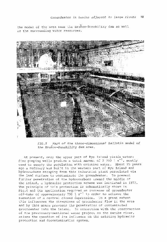
The detailed study of the influence of the Danube system was made on space ballotin models (Fig.5); the picture shows
18 J .Benet in et al.
FIG.3 Kydro-isohyps of the mean water table in Rye Island before realization of the Danube projects obtained with the help of the hybrid analogue.
FIG.4 Prediction of the mean water table in Rye Island after realization of the Danube projects obtained with the help of the hybrid analogue.
Groundwater in basins adjacent to large rivers 19
the model of the area near the Hrusov-Dunakility dam as well as the surrounding water resources.
-îBS*1*"' "V. •
f " "
* . " - • • *
. *j f '1*
V
FIG.5 Part of the three-dimensional ballotin model of the Hrusov-Dunakility dam area.
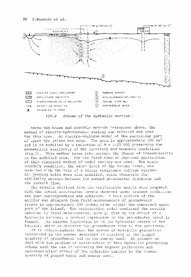
At present, only the upper part of Rye Island yields water: five pumping wells produce a total amount of 2 700 1 s~ , mostly used to supply the population with drinking water. About 25 years ago a refinery was built in the western part of Rye Island and hydrocarbons escaping from this industrial plant percolated via the land surface to contaminate the groundwater. To prevent further penetration of the hydrocarbons toward the middle of the island, a hydraulic protection scheme was initiated in 1972. The principle of this protection is schematically shown in Fig.6 and its application required an increase of groundwater off-take of approximately 750 1 s-1 in order to achieve the formation of a central closed depression. To a great extent this influences the directions of groundwater flow in the area and by this means prevents the penetration of contaminated groundwater into the island. In connection with the construction of the previously-mentioned water project on the Danube river, arises the question of its influence on the existing hydraulic protection and decontamination system.
20 J.Benetin et al.
R E F I N E R Y , ( J )
4iUiiUflHnu^lH—Il— t^
• Q=700-750 I s 1 • 8 = 380-400 Is
lïïiïffll COVERING SANDY LOAM LAYERS
g 5 3 GRAVEL-SAND SEDIMENTS
Fi^V] HYDROCARBONS WATER POLLUTION
«~ WATER FLOW DIRECTION
j L GROUND WATER TABLE
0 0 © ©
TERRAIN SURFACE
HYDROCARBONS I N F I L T R A T I O N
DANUBE RIVER BED
IMPERMEABLE LAYER
FIG.6 Scheme of the hydraulic barrier.
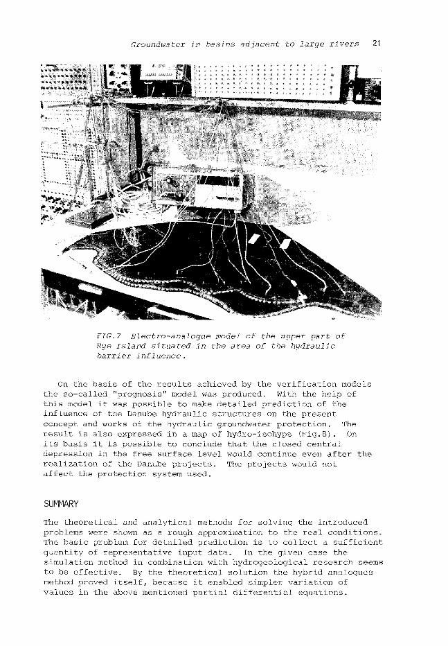
Among the known and possible methods introduced above, the method of electro-hydrodynamic analogy was selected and used for this task. An electro-analogue model of the particular part of upper Rye Island was made. The area is approximately 200 km2
and it is modelled by a reduction of M = 1:25 000 preserving the geometrical similarity of the territory and boundary conditions (Fig.7). This method takes into account the change of transmissivity in the modelled area. For the first time an improved application of this classical method of model analogy was used. The basic boundary condition, the water level of the Danube river, was modelled with the help of a linear resistance voltage divider. All pumping wells were also modelled, while observing the similarity measure between the pumped groundwater discharge and the current flow.
The results obtained from two verification models were compared with the actual groundwater levels observed under present conditions and good correspondence was achieved. A real picture of the aquifer was obtained from field measurements of groundwater levels in approximately 300 probes sited within the concerned upper part of Rye Island. The verification model confirmed the results obtained by field measurements, namely, that by the effect of a hydraulic barrier, a central depression in the groundwater level is formed. Its maximum depression is in the hydraulic centre of the barrier, which is decisive for, groundwater flow in the territory.
It is understandable that the system of hydraulic protection introduced in the manner described is exacting on the pumped quantity of groundwater and on the energy used. At present we deal with the problem of optimization of this hydraulic protection scheme with the aim of achieving the highest protective and decontamination effect of the hydraulic barrier by the lowest quantity of pumped water and energy used.
Groundwater in basins adjacent to large rivers 21
FIG.7 Electro-analogue model of the upper part of Rye Island situated in the area of the hydraulic barrier influence.
On the basis of the results achieved by the verification models the so-called "prognosis" model was produced. With the help of this model it was possible to make detailed prediction of the influence of the Danube hydraulic structures on the present concept and works of the hydraulic groundwater protection. The result is also expressed in a map of hydro-isohyps (Fig.8). On its basis it is possible to conclude that the closed central depression in the free surface level would continue even after the realization of the Danube projects. The projects would not affect the protection system used.
SUMMARY
The theoretical and analytical methods for solving the introduced problems were shown as a rough approximation to the real conditions. The basic problem for detailed prediction is to collect a sufficient quantity of representative input data. In the given case the simulation method in combination with hydrogeological research seems to be effective. By the theoretical solution the hybrid analogues method proved itself, because it enabled simpler variation of values in the above mentioned partial differential equations.

22 J.Benetrn et al.
FIG.8 Hydro-isohyps of the water table in the area protected by the hydraulic barrier before and after the realization of the Danube project obtained by the electro-hydrodynamic analogy.
For the solution of groundwater regime prediction it is possible to use several methods of physical and mathematical modelling depending on the character of the problem and the extent of the territory. The study of the correlation between aquifers and aeration zone of the soil profile is possible by means of the submodels of the water regime. They enable a better outline of the singularity influence by which they provide a more reliable and better modified picture of the condition and the changes within the filtration flow field.
Groundwater in basins adjacent to large rivers 23
REFERENCES
Benetin, J.: Soil Water Dynamics (in Slovak), VSAV, Bratislava, 1970, 268 pp.
Benetin, J., Okenka, I., Huska, D.: Calculation of the Necessary Irrigation Doses (in Slovak), Acta Fytotechnica, UA Nitra, 1978, p.190-210.
Benetin, J., et al.: Irrigation (in Czech), Priroda, Bratislava 1979, 543 pp.
Benetin, J., et al.: Determination of the Quantitative Statistical Characteristc of the Soil Water Balance Components (in Slovak), Vodohospodarsky casopis SAV, R.29, No.3, Bratislava, 1981, p. 241-255.
Childs, E.C.: The Physical Basis of Soil Water Phenomena, J. Wiley and Sons Ltd., London, 1969.
Halek, V.: La simulation des processus naturels et leur utilisation dans la solution des regimes des courants d'eaux sauterrains dans des regions étendues, AIRH-Neuviême Assemble General, Rapp. 11/34, Belgrade, 1961.
Halek, V.: Hydrotechnical Research 3, Analogy Methods in Hydraulic (in Czech), SNTL, Praha, 1965.
Halek, V., Nedoma, J.: Application of a Digital Computer to the Solution of Groundwater Montion in a Plane Flow Region (in Czech), Vodohospodarsky casopis SAV, No.l, Bratislava, 1965.
Halek, V., Novak, M.: Problems concerning Solution of Steady and Unsteady Groundwater Flow by Statistical Methods. IAHR Symp. Fundamentals of Transport Phenomena in Porous Media, Haifa, 1969.
Halek, V. & Svec, J.J.: Groundwater Hydraulics, (in Czech), ACADEMIA, Praha, 1973.
Radcenko, I.: Flow Field Aritificially Influenced by the Elements of Hydraulic Barrier (in Slovak), Technical Report IHH SAS, Britislava, 1979.


![Sustainable groundwater management of the …hydrologie.org/hsj/450/hysj_45_01_0147.pdfllydrological Sciences-Journal-des Sciences Hydrologiques, 45(1) February 2000 ]_47 Sustainable](https://img.pdfslide.us/doc/110x75/5e93ef74e367df5e4c585e5c/sustainable-groundwater-management-of-the-llydrological-sciences-journal-des-sciences.jpg)