Embed Size (px)
Citation preview

European Union Water Initiative Plus for the
Eastern Partnership Countries (EUWI+)
Result 2
METHODOLOGY FOR THE ASSESSMENT
OF GROUNDWATER STATUS IN THE
REPUBLIC OF BELARUS
Final report, December 2020

Methodology of groundwater status assessment
2
Beneficiaries
Ministry of Natural Resources and Environmental Protection of the Republic of Belarus
Responsible EU member state consortium EUWI+ project leader
Mr Alexander Zinke, Umweltbundesamt GmbH (AT)
EUWI+ country representative in Belarus
Mr Alexandr Stankevich
Responsible international thematic lead expert
Mr Andreas Scheidleder, Umweltbundesamt (AT)
Responsible national thematic lead expert
Ms Olga Vasneva, “Institute of Geology” branch of the Republican Unitary Enterprise "Research and Pro-
duction Center for Geology
Authors
Ms Olga Vasneva, Ms Olga Berezko, Ms Elena Cherevach, Ms Olga Buynevich, Ms Tatyana Kononova,
all “Institute of Geology” branch of the Republican Unitary Enterprise "Research and Production Center for
Geology”
Disclaimer:
The EU-funded program European Union Water Initiative Plus for Eastern Partnership Countries (EUWI+) is im-
plemented by the United Nations Economic Commission for Europe (UNECE), the Organisation for Economic
Co-operation and Development (OECD), both responsible for the implementation of Result 1, and an EU Mem-
ber States Consortium comprising the Environment Agency Austria (UBA, Austria), the lead coordinator, and the
International Office for Water (IOW, France), both responsible for the implementation of Results 2 and 3. The
program is co-funded by Austria and France through the Austrian Development Agency and the French Artois-
Picardie Water Agency.
This document was produced with the financial assistance of the European Union. The views expressed
herein can in no way be taken to reflect the official opinion of the European Union or of the governments of
the Eastern Partnership Countries.
This document and any map included herein are without prejudice to the status of, or sovereignty over, any
territory, to the delimitation of international frontiers and boundaries, and to the name of any territory, city or
area.
Imprint
Owner and Editor: EU Member State Consortium
Umweltbundesamt GmbH
Spittelauer Lände 5
1090 Vienna, Austria
Office International de l’Eau (IOW)
21/23 rue de Madrid
75008 Paris, France
Responsible IOW Communication officer:
Ms Chloé Déchelette [email protected]
December 2020

Methodology of groundwater status assessment
CONTENTS
1 Executive summary ............................................................................................................................ 8
2 Introduction ......................................................................................................................................... 9
3 Legal provisions and applied methodologies for assessing the status of groundwater quantity
and quality ........................................................................................................................................ 10
3.1 Summary of legal provisions .................................................................................................... 10
3.1.1 Legislation regarding GW monitoring in natural (low-disturbed) conditions ................... 10
3.1.2 Legislation regarding GW monitoring in disturbed conditions ........................................ 11
3.2 Summary of currently used methods for assessing the status of hydrodynamic and
hydro-geochemical regimes of groundwater in the Republic of Belarus .................................. 12
3.2.1 Sampling for hydro-geochemical regime assessment and level measurements for
hydrodynamic regime assessment ................................................................................. 12
3.2.2 Collecting, processing and transfer of primary information to the Information and
Analytical Center for Groundwater Monitoring for its subsequent adding to the
database "Groundwater of the Republic of Belarus" ...................................................... 14
4 Considered methods of status assessment and summary of the test results .................................. 15
4.1 Brief description of the considered methods of status assessment in accordance with
the principles of the WFD ......................................................................................................... 15
4.2 Summary of the results of the test condition assessment of groundwater status using
available monitoring data .......................................................................................................... 20
5 Proposed methodologies for the groundwater quantity and quality status assessment.
Summary of requirements and restrictions. ..................................................................................... 23
5.1 Assessment of the quantitative and qualitative groundwater bodies status in the context
of the Pripyat river basin ........................................................................................................... 25
5.1.1 Criteria for assessing the quantity status of a GWB ....................................................... 25
5.1.2 Criteria for assessing the quality status of a GWB ......................................................... 27
5.1.3 Criteria for assessing the quality risk of a GWB ............................................................. 28
5.2 Summary of method requirements and restrictions .................................................................. 29
6 Testing of the proposed methodologies (at 2 groundwater bodies in the Pripyat River Basin) ....... 30
6.1 GWB quality status assessment ............................................................................................... 30
6.2 GWB quantity status assessment ............................................................................................. 32
6.3 Summary of groundwater status assessments and conclusions.............................................. 35
7 Summary of open issues and missing data ..................................................................................... 37
7.1 Development of a regime network of observational wells in the Pripyat river basin: ............... 37
7.2 Transboundary groundwater monitoring of the Republic of Belarus and Ukraine.................... 39
7.3 Scientific aspects ...................................................................................................................... 40
7.4 Regulatory legal objectives ....................................................................................................... 40
8 Conclusions and results ................................................................................................................... 41
9 References ....................................................................................................................................... 42

Methodology of groundwater status assessment
4
List of Tables
Table 1: Maximum decrease in GW levels in the operated aquifer at the Ostrovy water intake ..... 24
Table 2: Background concentrations of NO3- component in GWBs BYPRGW0002 and
BYPRGW0006 .......................................................................................................................... 31
Table 3: The number of observation wells in which the nitrate content is above the
background and MPC in the GWBs BYPRGW0002 and BYPRGW0006 ................................ 32
Table 4: Determination of the qualitative status of the GWB BYPRGW0002 and
BYPRGW0006 .......................................................................................................................... 32
Table 5: The number of observation wells for which the hydrodynamic information
processing was performed according to the GWBs BYPRGW0002 and BYPRGW0006 ........ 33
Table 6: Maximum level decrease in exploited aquifers at operating water intakes over a 10-
year observation period ............................................................................................................ 34
Table 7: Number of observational wells and site density of the GWBs of the Pripyat river
basin ......................................................................................................................................... 38
Table 8: Suggestions for inclusion of existing observation points of the groundwater
monitoring network in the Pripyat river basin............................................................................ 38
Table 9: Suggestions for improvement and equipment of new observation points of the
groundwater monitoring network in the Pripyat river basin ...................................................... 39

Methodology of groundwater status assessment
Abbreviations
ADA ...................... Austrian Development Agency
DoA ....................... Description of Action
DG NEAR ............. Directorate-General for Neighbourhood and Enlargement Negotiations
of the European Commission
EaP ....................... Eastern Partnership
EC ......................... European Commission
EECCA ................. Eastern Europe, the Caucasus and Central Asia
EMBLAS ............... Environmental Monitoring in the Black Sea
EPIRB ................... Environmental Protection of International River Basins
ESCS .................... Ecological Status Classification Systems
EU ......................... European Union
EU-MS .................. EU-Member States
EUWI+ .................. European Union Water Initiative Plus
FD ......................... Floods Directive
GEF ...................... Global Environmental Fund
ICPDR ................... International Commission for the Protection of the Danube River
INBO ..................... International Network of Basin Organisations
IOWater/OIEau .... International Office for Water, France
IWRM .................... Integrated Water Resources Management
MSFD .................... Marine Strategy Framework Directive
NESB .................... National Executive Steering Board
NFP ....................... National Focal Point
NGOs .................... Non-Governmental Organisations
NPD ...................... National Policy Dialogue
OECD ................... Organisation for Economic Cooperation and Development
RBC ...................... River Basin Council
RBD ...................... River Basin District
RBMP ................... River Basin Management Plan
RBO ...................... River Basin Organisation
ROM ..................... Result Oriented Monitoring
SCM ...................... Steering Committee Meeting (of the EU Action EUWI+)
SEIS ..................... Shared environmental information system
TA ......................... Technical Assistance
ToR ....................... Terms of References
UBA ...................... Umweltbundesamt GmbH, Environment Agency Austria
UNDP .................... United Nations Development Programme
UNECE ................. United Nations Economic Commission for Europe
WISE ..................... Water Information System for Europe
WFD ...................... Water Framework Directive
Methodology of groundwater status assessment
6
Country Specific Abbreviations Belarus
BIEE .............................. Branch «Belarussian integrated exploration expedition» of the State Enter-
prise „RPCG“
ChNPP .......................... Chernobyl Nuclear Power Plant
Council of Ministers ...... Council of Ministers of the Republic of Belarus
GIS ................................ Geo-information system
GWB ............................. Groundwater body
IAC GM ......................... Informational and Analytical Center for Groundwater Monitoring of the Branch
„Institute of Geology“
Institute of Geology ....... Branch "Institute of Geology" of the Republican Unitary Enterprise "Research
and Production Center for Geology"
Ministry of Natural Resources ..... Ministry of Natural Resources and Environmental Protection of the
Republic of Belarus
MPC .............................. Maximum Permissible Concentration
NEMS ........................... National Environmental Monitoring System
RCAC ............................ State Enterprise „Republican Center of Analytical Control in the field of envi-
ronmental protection“ of the Ministry of Natural Resources of the Republic of
Belarus.
RUE «BelNITS ECOLOGIYA» .... Republican Research Unitary Enterprise „BelNITS „Ecologiya““
SE „RPCG“ ................... State Enterprise „RPCG“ ("Research and Production Center for Geology")
SWC ............................. State Water Cadastre
TCP ............................... Technical Code of Practice
Terms and Definitions
Hydrogeological post: consists of several observation wells, which are equipped for different aquifers
and are located in natural conditions.
Water intake (water intake facility): hydraulic structures designed for the intake of water from water
bodies (reservoir, watercourse, groundwater source).
Groundwater regime: changes in time and space of levels (pressure), temperature, chemical and
microbiological composition and other groundwater characteristics.
Monitoring observations: a system of regular observations of the groundwater state in terms of hy-
drogeological, hydrochemical and other indicators, assessment and forecast of its
change in conditions disturbed by operation.
Regime network: a set of observation points for the groundwater state and its pollution.
Groundwater observation points: observation well, the equipment of which allows for instrumental
observations of the groundwater state.
Natural conditions, groundwater is characterized by an undisturbed (natural) regime, which is
developed mainly under the impact of meteorological, hydrological, and geological
factors.
Disturbed (artificial) regime is a regime that is developed under the impact of new factors caused by
human activity. Groundwater regime can be violated by human disturbance in the
natural environment in connection with irrigation of fields; drainage of wetlands;
groundwater withdrawal for drinking, industrial and agricultural water supply; engi-
neering construction, including hydraulic, structures (water intakes); drainage of the
territory when exploiting minerals using mines or quarries.

Methodology of groundwater status assessment
Natural groundwater reserves: the volume of gravitational water contained in pores, cracks in water-
bearing rocks in its natural conditions.
Natural groundwater resources: amount of aquifer recharge in natural hydrogeological conditions.
Groundwater reserves: the amount of groundwater that can be extracted at a deposit (deposit site,
subsoil site) by geologically-technically justified water intake structures under a
given operating mode and conditions, as well as water quality that meets the re-
quirements of its intended use during the estimated service life from taking into ac-
count environmental and sanitary requirements and restrictions, as well as the
economic feasibility of their use.
Approved groundwater reserves: reserves that underwent the state examination and were approved
in accordance with the established procedure for their intended purpose, quantity
and categories of knowledge for entering on the state balance.
Permissible decrease: the value of the permissible decrease in the water level in the water intake is
determined based on the aquifer thickness, the value of the groundwater pressure,
technical capabilities upon condition that the damage to the environment is pre-
vented or minimized associated with the groundwater withdrawal. If the maximum
decrease in the water level is exceeded, formation drainage, failure of pumping
equipment and other may occur.
SanPiN 10-124 RB 99: Sanitary rules and regulations “Drinking water and water supply of populated
areas. Drinking water. Hygienic requirements for water quality of centralized drink-
ing water supply systems. Quality control. Sanitary rules and norms SanPiN 10-124
RB 99", approved by the resolution of the Chief State Sanitary Doctor of the Re-
public of Belarus as of October 19, 1999 No. 46, with the changes approved by the
Resolution of the Chief State Sanitary Doctor of the Republic of Belarus as of
March 26, 2002 No. 16 (hereinafter - SanPiN 10-124 RB 99).
Maximum permissible concentration (MPC): the maximum concentration when substances do not
have a direct or indirect impact on human health (when exposed to the body
throughout life) and do not worsen the hygienic conditions of water consumption.
Background concentrations: the average concentration of the target component of the studied ob-
ject.
Groundwater monitoring: a type of monitoring of the National Environmental Monitoring System in
the Republic of Belarus. Groundwater monitoring is carried out with the aim of ob-
serving hydrogeological, hydrochemical and other indicators of the groundwater
state, identifying negative processes, assessing and predicting their changes, pre-
venting their harmful consequences and determining the effectiveness of measures
aimed at rational use and groundwater protection.

Methodology of groundwater status assessment
8
1 EXECUTIVE SUMMARY
The “European Union Water Initiative Plus for Eastern Partnership (EaP) Countries (EUWI+)” in-
volves six eastern neighbours of the EU: Armenia, Azerbaijan, Belarus, Georgia, Moldova and
Ukraine. The EUWI+ project addresses existing challenges in both development and implementation
of efficient management of water resources and in particular the water monitoring capacities. It spe-
cifically supports the EaP countries to move towards the approximation to EU acquits in the field of
water management as identified by the EU Water Framework Directive
The assessment of the groundwater quantity and quality status is a very important milestone within
the implementation of the Water Framework Directive (WFD). It is the main tool for proving whether
the environmental objectives of the WFD have been met and whether the Programme of Measures is
effective in achieving the objectives.
A workshop in December 2019 in Minsk initiated the discussion about the development of national
methods for assessing groundwater quantitative and qualitative status by discussing the aims and
the requirements given in the WFD and by discussing different options and experiences from EU
Member States in establishing appropriate and tailored methods.
This workshop was the starting point for the present study which proposes national methods for
groundwater status assessment (both quality and quantity) by:
1. summarising the current state of legal requirements in which new methodologies need to fit in;
2. discussing the WFD requirements in the light of the legal provisions in the Republic of Belarus;
3. proposing methodologies for assessing groundwater qualitative and quantitative status;
4. testing the proposed methods by monitoring data of two groundwater bodies in the Pripyat river
basin; and
5. summarizing the identified gaps and open issues and proposing steps forward.

Methodology of groundwater status assessment
2 INTRODUCTION
Since 2018, EUWI+ supported significantly the elaboration of a number of pilot projects, aiming at
implementing the main groundwater monitoring related provisions of the WFD in a stepwise approach.
The implementation started with the identification (delineation) of groundwater bodies, their characteri-
zation, the assessment and enhancement of the groundwater monitoring networks and the perfor-
mance of several groundwater surveys to gather necessary data for the assessment of risk and
groundwater status. In parallel, also significant progress was made in terms of transboundary coopera-
tion with Ukraine in the identification of the transboundary parts of the neighboring groundwater bodies
and the proposal of a transboundary groundwater monitoring network.
The logical next step in the implementation of the WFD is the assessment of the groundwater quantita-
tive and qualitative status which indicates whether the environmental objectives of the WFD regarding
groundwater are met. Accordingly, countries need to establish appropriate and tailored methodologies
in assessing the status, by considering the variety of natural conditions, the uses and receptors of
groundwater and the availability of monitoring data gathered from the national monitoring networks.
Hence, the developed methodologies vary from country to country and are only comparable to a cer-
tain extent.
According to the WFD, an integrated approach is applied for assessing the status of groundwater bod-
ies. This approach consists in a comprehensive analysis and assessment of hydrodynamic and hydro-
geochemical data obtained by the monitoring of groundwater, together with a list of calculated indica-
tors (for example: the value of the permissible decrease, background concentration, etc.).
It is well recognised, that also the health of aquatic and terrestrial ecosystems, which are dependent to
groundwater, as well as saline and other intrusion have to be considered in the comprehensive status
assessment according to the WFD. Nevertheless, it was decided to focus first at the legitimate uses of
groundwater by the assessment of the groundwater body as a whole as groundwater abstraction for
drinking water purpose is of highest importance in the Republic of Belarus
Based on the existing regulatory and legal acts of the Republic of Belarus, as well as taking into ac-
count the requirements of the WFD, a methodological approach is proposed that includes criteria for
assessing the status of groundwater bodies. The development of methodological approaches and the
assessment of the status of groundwater bodies (“good”, “under risk”, “poor”) is being carried out for
the first time in the territory of the Republic of Belarus. This first attempt will be further evaluated and
enhanced in future, once first experiences could be gained in the application of the methods.

Methodology of groundwater status assessment
10
3 LEGAL PROVISIONS AND APPLIED
METHODOLOGIES FOR ASSESSING THE
STATUS OF GROUNDWATER QUANTITY
AND QUALITY
3.1 Summary of legal provisions
The water legislation of the Republic of Belarus is based on the norms of the Constitution of the Re-
public of Belarus. On the basis of the Constitution of the Republic of Belarus, a number of laws and
codes in the field of environmental protection have been adopted, which include: Law of the Republic
of Belarus dated November 26, 1992 No. 1982-XII "About environmental protection"; Code of the Re-
public of Belarus dated April 30, 2014 No. 149-З "Water Code of the Republic of Belarus"; Code of the
Republic of Belarus "About Subsoil" dated 14.07.2008 No. 406-З and others.
In accordance with the Water Code of the Republic of Belarus, the Water Strategy of the Republic of
Belarus has been developed, which determines the main areas of activity for protection and use of
water resources in the Republic of Belarus, ensuring a guaranteed supply of people with high-quality
drinking water, sustainable rational water use in industry and agriculture, protection of water bodies
and groundwater from pollution and excessive water withdrawal, protection of the population and terri-
tories from the negative impact of water, as well as a significant expansion of use of unique water
bodies for recreation and ecotourism by the population of the country, reduction of non-productive
costs in water management and increasing the return from water resource potential to the country's
economy. The strategy establishes the basic principles of state policy in the field of use and protection
of water resources, provides making and implementation of management decisions on preservation of
aquatic ecosystems, that provide the greatest social and economic effect, and creation of conditions
for effective interaction between participants in water relations [5, 6].
In order to protect and control groundwater usage in the territory of the Republic of Belarus, groundwa-
ter monitoring is carried out in natural (low-disturbed) and disturbed by operation (water intakes) condi-
tions, as well as in the area where local sources of pollution are located (municipal sources of pollu-
tion, filtration fields, etc.). Groundwater monitoring in the area of local sources of groundwater pollution
is not in the competence of the Information and Analytical Center for Groundwater Monitoring, which is
based in the Institute of Geology, a branch of the State Enterprise "Scientific Research Center for Ge-
ology" of the Ministry of Natural Resources of the Republic of Belarus [2].
3.1.1 Legislation regarding GW monitoring in natural (low-disturbed)
conditions
On the basis of the Resolution of the Council of Ministers of the Republic of Belarus of April 28, 2004
N 482 "On approval of provisions on the procedure for monitoring surface water, groundwater, atmos-
pheric air, local environmental monitoring and use of these data as part of the National Environmental
Monitoring System in the Republic of Belarus" the following provisions were approved: the procedure
for conducting groundwater monitoring within the NEMS and using its data; on the Information and
Analytical Center for Groundwater Monitoring of the National Environmental Monitoring System in the
Republic of Belarus.
On the basis of the Order of the Ministry of Natural Resources of the Republic of Belarus dated
07.19.2019 No. 180-OD, the Instruction on the technology of work on the organization and conduct of

Methodology of groundwater status assessment
groundwater monitoring was approved. The same Order defines the number and location of observa-
tion points of the state network for observing the groundwater state, a list of parameters, frequency of
observations and a list of organizations that monitor groundwater through the state regime well net-
work.
According to the order of the Ministry of Natural Resources and Environmental Protection of the Re-
public of Belarus dated July 19, 2019 No. 180-OD, the frequency of monitoring groundwater level re-
gime is carried out once every 10 days, and the quality (macro components and organoleptic indica-
tors – once a year, micro components – once per five years). The list of micro- and macro components
is the following: pH, total hardness, total mineralization (dry residue), permanganate oxidizability, chlo-
rides, sulfates, carbonates, hydrocarbonate ion, nitrates (by NO3-), sodium, potassium, calcium, mag-
nesium, ammonia (by nitrogen), free carbon dioxide, iron (in total), activated silicic acid (by Si), nitrite
ion, fluorides, manganese (in total), boron (B), polyphosphates (by PO4), lead (in total), copper (in
total), zinc, cadmium (in total).
The groundwater quality is assessed in accordance with the requirements of SanPiN 10-124 RB 99
"Potable water and water supply of residential areas. Hygienic requirements and quality control of
potable water quality in centralized potable water supply systems".
3.1.2 Legislation regarding GW monitoring in disturbed conditions
Based on the Water Code of the Republic of Belarus (Article 12, paragraph 1.8), the Ministry of Natu-
ral Resources of the Republic of Belarus, together with the Ministry of Health of the Republic of Bela-
rus, is responsible for maintaining the State Water Cadastre; Resolution of the Council of Ministers
"Regulations on the procedure for maintaining the State Water Cadastre" dated March 12, 2010 No.
345 approves the procedure for maintaining the SWC, which is systematized data on quantity and
quality of water, as well as its use; The RB Water Code (Article 30) defines the procedure for issuing
permits for special water use (water intake from water resources or its reduction, etc.); The Subsoil
Code (Article 33) defines the procedure for granting a mining allotment (a subsoil plot provided to a
subsoil user for mining, etc.).
In accordance with the Code about Subsoil of the Republic of Belarus, an assessment of operational
reserves and state examination should be carried out for all subsoil plots provided for groundwater
extraction, in accordance with the requirements of the Technical Code of Practice "Rules for the as-
sessment of operational reserves of drinking and technical groundwater for subsoil areas operated by
single water intakes”.
Requirements for organization of sanitary protection zones and their observance are complied with
SanPiN No. 142 of 30.12.2016.
Geological norms and rules "Requirements for observing the groundwater regime" have been devel-
oped, but have not yet come into force.
Currently, in the Republic of Belarus there are no methodologies approved in the established manner
for assessing the state of quantity and quality of groundwater, along with this, the basic principles and
approaches to groundwater monitoring have been determined: the frequency of sampling; sampling
process; analysis of the data obtained, etc., which are based on the Methodological Recommenda-
tions "Organization and production of observations on the pressure and flow rate regime" developed in
1983 by the All-Union Hydrogeological and Engineering-Geological Institute (VSEGINGEO), Moscow.
These Guidelines set out the requirements for composition and location of the network of observation
points, equipment and design of observational wells, operation network monitoring, etc. [7].

Methodology of groundwater status assessment
12
3.2 Summary of currently used methods for assessing the
status of hydrodynamic and hydro-geochemical regimes of
groundwater in the Republic of Belarus
To assess the state of level regime and quality of groundwater in the territory of the Republic of Bela-
rus, in general, and in the Pripyat river basin, in particular, an algorithm of sequential actions has been
developed, which includes:
sampling for determining the hydro-geochemical composition and level measurement for deter-
mining the hydrodynamic regime of groundwater;
collecting, processing and transfer of primary information to the IAC GM for its subsequent add-
ing to the database "Groundwater of the Republic of Belarus";
processing, analysis and evaluation of hydrodynamic and hydro-geochemical data;
conclusions, annual reports and publications, provision of received information to the Ministry of
Natural Resources of the Republic of Belarus and interested parties for making management
decisions.
3.2.1 Sampling for hydro-geochemical regime assessment and level
measurements for hydrodynamic regime assessment
Conducting field research with hydro-geochemical sampling of groundwater is a rather serious stage
and, to some extent, laborious work that requires an understanding (intuition) of the hydrodynamics
and hydrochemistry of the research area by a hydrogeologist.
Nevertheless, like any other work, the work on sampling groundwater is quite consistent, staged and
includes:
1 stage – Preparation / planning of sampling;
2 stage – Survey / inspection of well(s);
3 stage – Pumping of well(s);
4 stage – Sampling;
5 stage – Transporting and storage of samples.
At the first stage (even before visiting the well), the scheme of its location is considered, the route to
it is specified, its passport data, including information about geological and hydrogeological conditions,
primary information about the chemical state of groundwater, static and dynamic levels, etc. At this
stage, an idea is formed about the hydrodynamic and hydro-geochemical state of groundwater in the
study area. It is necessary to clearly present the list of chemical components and become familiar with
sampling techniques / features. This is necessary in order to have certain chemical reagents (buffers)
with you for preservation of groundwater samples, to know the volume of containers for sampling.
It is important to check and prepare all the necessary equipment for determining the coordinates of the
well (GPS), sampling, conservation, transporting samples to the laboratory, etc. For all wells on which
samples will be taken, field protocols, acts, labels are prepared to record the results of field studies,
etc.
It should be noted that a well-planned first stage saves time and minimizes the problems that often
arise during field work.
The first stage results are:

Methodology of groundwater status assessment
1. Description of general information about the study area, including geological, hydrogeological,
hydro-geochemical characteristics, anthropogenic load, etc.;
2. Preparation of the necessary equipment, namely: sampler, level gauge, pH, Eh-meters, con-
tainers for sampling, gloves, tape, buckets, cellophane (for covering equipment from rain /
snow), chemicals for preserving samples, field journals, acts, labels, containers for storing
samples at low temperatures, rope, laptop with software for documenting groundwater moni-
toring results, keys to wells, pump, battery, sampler.
At the second stage, the technical condition of the well is checked (coloring of the head, the pres-
ence of the well number on the head, measuring the depth, assessing the state of the water intake
part, silting, the presence and operation of the level gauge).
To ensure high quality of regime observations, a control inspection of wells of the regime network is
periodically carried out. The inspector, in the presence of an observer, conducts measurements of
water level and temperature, depth of each well, minor repairs of wells, inspection of the area around
observation points within a radius of 0.5-1.0 km.
The result of the second stage is: assessment of the well condition, preparation for pumping and sam-
pling.
At the third stage, before pumping the well, the water level is measured. Next, the well is pumped,
which provides a change of at least four to five volumes of water in the wellbore (the volume is calcu-
lated by the formula taking into account the radius of a well pipe and the height of water column inside
it) with manual or electromechanical pumps. After pumping, before sampling, pH, electrical conductivi-
ty, dissolved oxygen, and groundwater salinity are measured. All information received is recorded in
field logs.
The result of the third stage is an inflow of groundwater from the reservoir for subsequent sampling,
obtaining primary data.
At the fourth stage, once a year, if possible, during the summer-autumn dry season, groundwater
samples are taken. Water samples are taken from operational wells after preliminary pumping with 3-
time replacement of the water column. Water sampling is carried out with a sampler in a container
made of glass or chemically resistant polymer materials. The volume and preservation of samples are
determined by the type of analysis and must be sufficient for the method used. Each container with a
water sample must be labeled immediately after sampling.
The result of the fourth stage is obtaining and preparation for transportation of containers with water
samples.
The fifth stage is also a quite responsible part of the entire process listed above. During transporta-
tion, containers with samples (water) are placed inside a container (container, box, etc.), which pre-
vents contamination and damage of containers with samples.
Samples for immediate examination are grouped separately and sent to the laboratory.
In the Republic of Belarus, when monitoring the groundwater state by hydro-chemical indicators, se-
lection, storage and transportation of water samples are carried out in accordance with the require-
ments of STB GOST R 51592-2001 “Water. General requirements for sampling" (hereafter referred to
as STB GOST R 51592-2001); STB ISO 5667-14-2002 “Water quality. Sampling. Part 14. Guideline
on ensuring of quality during water sampling and handling with sample tests (hereinafter referred to as
STB ISO 5667-14-2002); Order No. 180-OD dated 07.19.2019.
The result of the fifth stage is the delivery of water samples to the laboratory, with registration in the
journal of incoming documents with the assignment of a laboratory identification number.

Methodology of groundwater status assessment
14
3.2.2 Collecting, processing and transfer of primary information to the
Information and Analytical Center for Groundwater Monitoring for its
subsequent adding to the database "Groundwater of the Republic of
Belarus"
The obtained primary hydro-geochemical and hydrodynamic data are sent to the BIEE branch from the
"Central Laboratory" of the State Enterprise "Scientific Research Center for Geology" (hydro-
geochemistry), observers and level gauges (hydrodynamics) in the form of protocols and electronic
files.
Further, at the primary level, the processing of the received data is carried out, which consists in
checking the correct filling in the field logs, plotting annual chronological graphs, identifying and de-
termining errors in measurements, comparing the data with data on precipitation, air temperature, etc.
The chronological graph is updated immediately after the field books are received by the BIEE.
Identification and elimination of errors, as well as restoration of missed measurements is carried out by
visual assessment of the chronological graph. Chronological annual graphs are plotted using data
from all observational wells for all years of observation.
The obtained hydro-geochemical data is compared with SanPiN 10-124 RB 99 [4]. Usually, if the ana-
lyzed value is within the limits of the detection limit, then the sign less is written with the value of the
lower detection limit in the analytical protocols (for example: <0.5 mg/dm3).
The verified and processed primary data is entered into specially developed formats for transfer to the
IAC GM with the aim of their subsequent adding to the database "Groundwater of the Republic of Bel-
arus".
In the IAC GM primary data is added to the database "Groundwater of the Republic of Belarus" and
are summarized in the form of tables, graphs, cartographic material, etc. Assessment of level regime
state and groundwater quality in the Republic of Belarus is carried out both in natural (low-disturbed)
and disturbed conditions, conclusions are made. For example: when identifying high concentrations of
a nitrogen-containing group in groundwater, the influence of natural and anthropogenic factors is taken
into account; high contents of iron and manganese are due to the influence of natural factors, etc.
Changes in hydrodynamic conditions are also analyzed and evaluated. For each deviation / decrease,
the reasons are defined if possible.
Based on the collected, processed, evaluated data, reports, annual publications, conclusions, etc. are
made. All information is transferred to the Ministry of Natural Resources of the Republic of Belarus and
people interested in making management decisions.

Methodology of groundwater status assessment
4 CONSIDERED METHODS OF STATUS
ASSESSMENT AND SUMMARY OF THE
TEST RESULTS
In the period from 2018 to 2020, under the EUWI+ project and with the joint participation of Belarusian,
Ukrainian and Austrian hydrogeologists, a number of pilot projects were carried out aimed at further
developing the RBMP, development of national groundwater monitoring and transboundary coopera-
tion with Ukraine, with the aim of rational groundwater management.
The implementation of these projects made it possible to gain experience in terms of groundwater
monitoring in the European Union, get acquainted with a number of regulatory legal acts and guidance
documents developed in the EU and borrow some aspects (without violating the legislation of the Re-
public of Belarus) with the aim of further development and improvement of groundwater monitoring in
territory of the Republic of Belarus.
4.1 Brief description of the considered methods of status
assessment in accordance with the principles of the WFD
As a result of studying the EU regulatory documents (approaches, methods) in terms of groundwater
monitoring, some important components for the Republic of Belarus have been noted / highlighted,
which, in our opinion, will allow a more comprehensive approach to assessing the state of not only
groundwater in the Republic of Belarus (their status assessment), but also all ecosystems that depend
on the quantity and quality of groundwater (surface water, wetlands, forests, etc.).
For this, RBMPs are being developed in the EU, in accordance with the requirements and principles of
the WFD. The RBMP prescribes and compiles programs for each of the types of monitoring (observa-
tional, operational), prescribes frequency of sampling, level recordings, determines the status of the
GWB, etc.
With regard to determination of the GWB status, according to the provisions of the WFD, “good sta-
tus” of groundwater has a comprehensive understanding and combines “good chemical status” and
“good quantitative status” of groundwater.
According to the Groundwater Directive, a status assessment should only be carried out for GWBs
that are identified as being at risk [1]. Groundwater bodies not at risk are automatically classified as
being of good status. Nevertheless, the risk assessment requires also the validation of the risk as-
sessment by monitoring data. This means that all groundwater bodies are subject to an assessment
by using monitoring data.
The status assessment is carried out using the available groundwater monitoring data collected during
the RBMP period (from surveillance and operational monitoring) and is carried out at the end of the
RBMP (every 6 years) to reflect the effectiveness of programs of measures that were previously identi-
fied. In addition to assessing the status, the results of risk assessment are also taken into account (the
status assessment is about the effectiveness of the measures, the risk assessment looks into the fu-
ture). At the beginning of each RBMP cycle, a risk assessment takes into account pressures and im-
pacts and gives an estimate of the state of groundwater at the end of the cycle, and the risk assess-
ment is validated by using the data from surveillance monitoring.

Methodology of groundwater status assessment
16
The WFD aims at achieving “good chemical status” of groundwater bodies, considering: there is no
salt or any other intrusion; the relevant EU standards and groundwater threshold values have not been
exceeded; there is no negative impact on groundwater associated surface water ecosystems and
groundwater dependent terrestrial ecosystems (e.g., wetlands) and the drinking water treatment efforts
shall not increase due to changes in groundwater quality.
For the assessment of groundwater chemical status, the WFD requires that “…in assessing status, the
results of individual monitoring points within a groundwater body shall be aggregated for the body as a
whole….:
the mean value of the results of monitoring at each point in the groundwater body or group of
bodies shall be calculated, and
in … these mean values shall be used to demonstrate compliance with good groundwater
chemical status.
“Good quantitative status” means that the available groundwater resource is in the long term not ex-
ceeded by groundwater withdrawal and that there is sufficient groundwater flow to support the ecologi-
cal functions of associated aquatic and terrestrial ecosystems. Furthermore, the groundwater level is
not altered such as it would cause any saline or other intrusion and any damage to groundwater asso-
ciated surface water ecosystems and groundwater dependent terrestrial ecosystems (e.g., wetlands).
In the territory of the Republic of Belarus in the Water legislation there are no such concepts as “good
quantitative” or “good quality” status of groundwater. We speak of a good condition of groundwater in
general if: the fluctuation of groundwater level regime changes within climatic values and depends on
natural and geological-hydrogeological conditions; the permissible decrease, calculated when as-
sessing the exploitation of reserves at the water intake, significantly exceeds the actual one; there are
no tendencies (no dynamics) to an increase in the content of chemical components in the GWB (fluc-
tuations of hydro-geochemical components are within the background values); the quality of ground-
water meets the requirements of SanPiN 10-124 RB 99.
In terms of frequency of hydro-geochemical and hydrodynamic data obtaining, in stable groundwater
systems the monitoring program may be limited to two samples per year, while in more dynamic sys-
tems (e.g., karst aquifers), quarterly and more frequent sampling may be required.
It is recommended that groundwater samples from monitoring wells and/or springs are taken at refer-
ence points at least four times per year in order to determine seasonal fluctuations in the chemical
composition of groundwater. The sampling frequency may be reduced later, but it is recommended
that at least two sampling campaigns are carried out per year.
The frequency of monitoring is determined by the amount of data that is needed to determine the risk
and status and, if necessary, to assist in the design and evaluation of the program of measures. If
during the RBMP specialists see that there is not enough data to investigate and obtain the required
result, the frequency of sampling and level measurements may increase.
In the Republic of Belarus, observations on the groundwater hydrodynamic state in natural conditions
(at observation points of the state observation network within the NEMS) is carried out once every 10
days; on the hydro-geochemical state: macro components and organoleptic indicators once a year,
micro components once every 3 years at observation points of transboundary category, 1 time per 5
years at observation points of background category and observation points without category (accord-
ing to the Order of the Ministry of Natural Resources and Environmental Protection of the Republic of
Belarus No. 180-OD dated July 19, 2019 "On monitoring surface and groundwater at observation
points of the National Environmental Monitoring System in the Republic"). Observations on groundwa-
ter state in areas, where local sources of groundwater pollution are located, are carried out once a
year during the recession of the spring flood (the list of components to be determined and the fre-
quency of sampling are defined by the Resolution of the Ministry of Natural Resources of 11.01.2017
No. 5 (as amended by the Resolution of the Ministry of Natural Resources dated 22.07.2020 No. 15)).

Methodology of groundwater status assessment
The groundwater quantitative monitoring network in Austria (area 83,879 km2) consists of about 3000
monitoring sites (this includes observational wells, wells for drinking water supply (water intake wells),
wells for industrial water supply, and also wells used for other purposes). While, for example, the basin
area of the Pripyat river is 114,300 km2,the number of operating observational wells of the state net-
work located in this territory and intended for monitoring the groundwater state is 75 (106 – together
with the abandoned ones).
It is important to consider, that the EU WFD groundwater status assessment (both quantity and quali-
ty) is based on a combination of individual, relevant tests both on the level of the entire groundwater
body as a whole and tests which consider the location of exceedances, in particular when assessing
saline or other intrusion and when assessing the impacts on aquatic and terrestrial ecosystems. Data
aggregation of individual monitoring results is always needed. For this, geographic information sys-
tems are widely used and mathematical modeling is applied where the situation is critical as the efforts
of modelling are quite demanding and high.
Both Austrian and Belarusian experts attach great importance to quality assured sampling techniques
and laboratory performance. Having international experience in the EUWI+ project, Belarusian special-
ists have shown excellent results in this direction. In the Republic of Belarus, sampling of groundwater
for hydro-geochemical indicators and their testing is carried out in accordance with the requirements of
technical regulatory legal acts STB ISO 5667-11-2011. The only difference is that in the EU, when
taking samples, field equipment for measuring pH, electrical conductivity, oxygen concentration, tem-
perature, as well as sometimes test strips for express analysis of water samples.
When taking a more detailed look at the methods related to the assessment of the quantity and quality
of groundwater, then for the quantitative assessment of groundwater, the WFD requires the measuring
of the level of groundwater in wells and the related guidance document recommends also the measur-
ing of the flow rate of springs, runoff characteristics and/or levels of surface watercourses during the
dry season, water levels in wetlands and lakes, significantly dependent on groundwater, which is also
relevant for the Republic of Belarus. Also, in order to determine the overall quantitative status of the
GWB according to the requirements and objectives of the WFD, a series of tests is used that consider
the impact of changes in groundwater levels due to anthropogenic factors and/or runoff. The results of
all relevant tests together indicate whether the GWB meets the environmental objectives and the
GWB is of good quantitative status.
The series of tests includes:
1. Water balance: the long-term average annual withdrawal from the GWB should not exceed
the long-term average recharge. This test takes into account the cumulative effect on the
GWB and is a whole body test;
2. Surface water: there should be no significant deterioration in the chemical composition or
ecology of surface water;
3. Terrestrial ecosystems dependent on groundwater: there should be no significant damage
to a terrestrial ecosystem that depends on groundwater;
4. Salt (or other) inclusions: there should be no intrusion of saline solutions (or other pollu-
tants) as a result of anthropogenic impact and/or change in pressure, decrease in flow or
change in direction of flow as a result of water withdrawal
5. Drinking water protected areas: No deterioration in quality of waters intended for human
consumption. No increased water treatment due to anthropogenically induced change in
groundwater quality. [3].
When assessing the GWB quality in accordance with the requirements of the EU WFD, the mandatory
components that must be determined when carrying out a particular groundwater monitoring program
are: oxygen content; pH; conductivity; nitrates; ammonium. The list of other components is selected
depending on the characterisation of the GWB and the sources of groundwater pollution identified in

Methodology of groundwater status assessment
18
the characterisation process and the pressure and impact assessment (risk assessment). At the same
time, the sampling frequency should be linked to the regime of infiltration and recharge of aquifers and
to seasonal changes in the use of agrochemicals that cause groundwater pollution.
Assessment of groundwater quality both in the Republic of Belarus and in the European Union begins
with the fact that hydro-geochemical data is compared with existing norms, standards, threshold and
background values.
The good chemical status of groundwater in the European Union is based on: quality standards, as
well as background and threshold values for those pollutants that cause a risk that a groundwater
body is failing to achieve the good chemical status at the end of the management plan period. The
threshold values take into account both the variability of the natural quality of groundwater (natural
background levels) and the needs of the receptors (e.g. human health via drinking water, ecosystems
health, agriculture use, etc.).
The Groundwater Directive lists substances for which there are quality standards already applied
throughout the European Union. For other substances that cause risks to achieving good groundwater
quality status, countries impose threshold values themselves. The threshold value is understood as an
individual quality standard for a specific country, region, river basin or GWB. The concept of "threshold
value" was introduced because natural conditions are not homogeneous, therefore, the composition of
water in different regions / river basins, etc. will not be homogeneous [3].
The minimum list of components for which Member States have to consider the establishment of
threshold values includes: Cd, Pb, Hg, NH4, NO2, Cl, SО4, phosphorous (total/orthophosphate, trichlo-
roethylene, perchloroethylene, electrical conductivity.
Such threshold values can be set at the national level, at the level of an individual river basin, or at the
level of one groundwater body or a group of such bodies.
For transboundary groundwater bodies, threshold values are coordinated with the values adopted with
neighbouriпg countries. The Groundwater Directive recommends that countries establish their own
“thresholds” taking into account the identified risks associated with specific anthropogenic impacts.
When setting thresholds, countries need to take into account the natural background concentrations of
naturally occurring substances [8]. Compared to a quality standard, a “threshold” can be more striсt.
For example, if concentrations of components in groundwater are below quality standards, and they
lead to chemical or ecological disturbances in groundwater-related ecosystems, then more striсt val-
ues should be set, which are then called “threshold values”.
Furthermore, the establishment of “threshold values” considers the natural background values and
quality standards of the receptors of the groundwater. For example: in some EU Member States the
drinking water standard for chloride is 200 mg/dm3. If, for example, the natural background value of
chloride is already 300 mg/dm3, then a threshold value cannot be lower than 300 mg/dm
3. If the natu-
ral background level of chloride, for example, is 100 mg/dm3, then the threshold is often somewhere
between 100 and 200 mg/dm3. Austrian establishes the groundwater threshold values at 90% of the
drinking water standard (for example, for chlorides, it is 200 mg/dm3), which it results in a "threshold
value" for chloride of 180 mg/dm3.
The Groundwater Directive describes how countries determine their own “thresholds“ based on the
identified risks associated with specific anthropogenic impacts. Countries need to take into account
natural background concentrations of naturally occurring substances when setting thresholds and the
needs of the receptors of the groundwater. For more details on approaches to setting the threshold
values, see [3].
When processing data, both in the European Union and in the Republic of Belarus, special attention is
paid to the length of the time series of the data, on the basis of which the analysis and processing of
data is carried out in order to subsequently assess the status of the GWB. According to the recom-
mendations of the CIS guidance documents, the length of the time series that should be used de-

Methodology of groundwater status assessment
pends on the conceptual model of the groundwater body, the temporal evolution of concentrations and
changes in the quality of the monitored data. Too long time series can lead to biased results because
low or high values in earlier years of the time series influence the conclusions todays status [3]. For
example, in Austria for the analysis of hydro-geochemical data, the length of the series is 3 years.
Data processing consists in calculating average annual values for each substance and for each
groundwater monitoring site which is then followed by the calculation of a 3-year average value per
monitoring site. This 3-annual value is compared with the threshold value for this substance and de-
cides whether a monitoring site is called “endangered” if it exceeds the threshold value or not.
Further, for each GWB, the percentage of those groundwater monitoring sites is calculated, where the
average value over 3 years exceeds the threshold value. If this percentage exceeds a certain limit
(e.g. 20-25%) then the GWB has a “poor groundwater chemical status”.
In assessing groundwater trends, the WFD provides a concept of “starting point for a reversal of an
upward trend in concentrations” – a starting point for implementing measures to change trends. This
point is the one when concentration of a substance has reached a value when it is necessary to take
measures to reverse the upward trend (dynamics to increase) so that this trend does not exceed the
threshold value.
This point is defined as a percentage of a threshold value or quality standard. The Groundwater Di-
rective proposes to use 75% of the threshold value as a starting point for a trend reversal. This per-
centage can be determined individually for each GWB, depending on different geological and hydro-
geological conditions and characteristics of the pollutant. For example*1: Cretaceous GWBs are very
dynamic and quickly respond to changes in their hydrochemistry and hydrodynamics. This means that
any measure implemented can lead to a very rapid improvement of the GWB quality. As a result, we
can postpone the implementation of environmental protection measures and apply a higher % (for
example, 85%). On the other hand, if we consider deeper aquifers, which react to ongoing processes
very slowly, then it is advisable to start implementing measures earlier and use a lower % value (for
example, 60%), since the purpose of the research is to prevent the exceedance of the established
standard by the trend, since it may take years for such aquifers to improve their condition, although
environmental measures have long been implemented. The overall goal is that the upward trend does
not exceed any threshold value. It is also based on the experience and intuition of an expert who can
predict preliminarily / approximately how long it will take for the GWB to react to the implemented
measures (measures to prevent the spread of pollution).
As noted earlier, the concept of “good chemical status” is absent in the regulatory legislation of the
Republic of Belarus. At the same time, in the territory of both the Republic of Belarus, in general, and
of the Pripyat river basin, in particular, a good hydro-geochemical state can be asserted if the content
of the determined components meets the established requirements of SanPiN 10-124 RB 99 and the
hydro-geochemical indicators change within the background values typical for a particular territory of
the country, a particular river basin, and also if there are no trends towards an increase in the content
of one or another component. When hydro-geochemical data is compared with SanPiN, about it
means that the data are compared with maximum permissible concentrations (MPC). By MPC we
mean the maximum concentrations at which the substances do not have a direct or indirect effect on
human health (when exposed to the body throughout life) and do not make the hygienic conditions of
water consumption worse.
In the Republic of Belarus, in general, and in the Pripyat River basin, in particular, the time series of
observations are 5 years (while the frequency of groundwater sampling is 1 time per year). The data
obtained during implementation of groundwater monitoring in natural (low-disturbed) conditions and
conditions disturbed by operation are systematized in the form of graphs, diagrams, tables and then
compared with the background values. Thus, tendencies to an increase in the content of one or an-
other component and cases of exceeding the MPC are determined.
1 An example was kindly provided by the Austrian expert on groundwater

Methodology of groundwater status assessment
20
Based on the analysis of the tabular material, wells are selected in which the hydro-geochemical char-
acteristics of groundwater do not meet the established requirements. If the condition of groundwater
does not meet the defined requirements, then a kind of test approach is performed. It is clarified, which
of the factors could affect the change in the state of groundwater quality: natural or anthropogenic. If
these are natural factors, then recommendations on the possibilities of further operation of the water
intake / deposit are offered. If these are anthropogenic ones, it is assumed which of the pollution
sources could have influenced such a change in the state of groundwater. In such cases, additional
research is recommended.
Based on this approach, an idea of groundwater quality state within the hydrogeological station and
water intake is compiled. In the Republic of Belarus, observations on the groundwater hydro-
geochemical regime are carried out at local sources of groundwater pollution.
Quarterly and annual studies, conclusions on the state of groundwater for all types of groundwater
monitoring are published in reports, publications that are submitted to the Ministry of Natural Re-
sources of the Republic of Belarus.
For the further development and improvement of groundwater monitoring in the Republic of Belarus, it
is necessary to solve a number of scientific, industrial and regulatory legal tasks, which are presented
in detail in Chapter 7.
In general, comparing the methods and approaches of the EU and the Republic of Belarus, it should
be noted that the approaches used to assess the status of GWBs in the EU are quite complex. It is
important to understand that some ecosystems are dependent on groundwater and, in their turn, are
indicators of groundwater state.
In further work in terms of groundwater monitoring and assessment of the GWBs status in the Repub-
lic of Belarus, it will be useful to use such WFD concepts as: “threshold value”, “starting point for a
trend reversal”. After the completion of work on determining the coordinates of observational wells, the
development and creation of GIS for groundwater of the Republic of Belarus and taking into account
the recommendations of the WFD, it will be useful to revise the approaches to statistical processing of
hydro-geochemical and hydrodynamic data.
The set of scientific and practical measures listed in this chapter and in Chapter 7 will allow to run a
full determination of the GWBs status of the Pripyat river basin and will be an example for determining
the GWBs status for other river basins of the Republic of Belarus, which in its turn will improve the
RBMP quality.
4.2 Summary of the results of the test condition assessment of
groundwater status using available monitoring data
This chapter will present an approach to determining the quantitative and qualitative status of GWBs in
the territory of the Republic of Belarus (using the example of the Pripyat river basin). In accordance
with the requirements of the WFD and the regulatory legal acts of the Republic of Belarus, criteria are
proposed for determining the status of the GWBs of the Pripyat River basin.
To determine the quantitative and qualitative status of the GWBs in the territory of the Republic of
Belarus (using the example of the Pripyat river basin), first of all, we have a conceptual understanding
of the formation factors of groundwater hydrodynamic and hydro-chemical regime in the Pripyat river
basin. In other words, it is necessary to have an idea, which of the GWB formation factors can have /
has an impact on the status of the GWB of the Pripyat River basin, which will / does lead to a change
in the hydrodynamic or hydro-geochemical characteristics.
Methodology of groundwater status assessment
The concept is based on the knowledge that the GWBs in the Pripyat river basin are influenced by
natural and anthropogenic factors, which mainly determine their status.
Natural factors primarily include climatic factors (precipitation, temperature, etc.), geomorphological,
geological and hydrogeological features (swampiness of the territory, dynamics of groundwater, com-
position of water-bearing rocks, etc.). Anthropogenic factors are reclamation activities, mining, agricul-
tural activities, concentrated water intake, etc.
As a result of the influence of natural factors there is a high content of organic matter (up to 100–300
mg/dm3) in the GWBs of the Pripyat River basin, represented mainly by fulvic and humic acids. These
water bodies are characterized by high iron content, sometimes reaching 25–30 mg/dm3 (with an MPC
of 0.3 mg/dm3). That is why the residue of groundwater is colored from light red to brown. The maxi-
mum values of mineralization (up to 600 mg/dm3) are observed within river floodplains and the first
above-floodplain terraces, i.e. in areas of aquifer discharge. Here, a sharp increase in the content of
Cl- and Na
+ (up to 120-220 mg/dm
3) is recorded in groundwater, and the water composition becomes
hydrocarbonate-chloride calcium-sodium, etc.
As a result of the influence of anthropogenic factors, in the GWBs of the study area, there is a de-
crease in the phreatic groundwater and associated confined aquifers levels (the influence of land rec-
lamation, water intake, drainage measures, etc.), as well as an increase in the content of the nitrogen-
containing group, sometimes pesticides, etc.
Without going into detail on the conceptual understanding of the hydrodynamics and hydrochemistry
of the GWBs in the Pripyat river basin, in order to assess the hydrodynamic and hydro-geochemical
state of the GWBs in the study area of the Pripyat river basin, groundwater is monitored in natural
(low-disturbed) and by operation disturbed conditions, as well as in areas where local sources of
groundwater pollution are located.
In natural conditions, level regime and groundwater quality monitoring is carried out at 25 hydrogeo-
logical stations (76 observational wells), which are located at various GWBs and 5 water intakes.
To assess the qualitative status of the GWBs in the territory of the Republic of Belarus, in general, and
in the Pripyat river basin, in particular, the approved document SanPiN 10-124 RB 99 is used, as well
as background indicators (not approved legislatively), which are determined for each GWB in the Pri-
pyat river basin.
Hydro-geochemical status assessment of the GWBs in natural (low-disturbed) conditions consists in
the analysis of the obtained hydro-geochemical data on hydrogeological stations for the previous 5
years and the last year (plotting of graphical, tabular material, etc.). In process of analyzing hydro-
geochemical data, the status of groundwater is determined both in each well and the GWB as a whole.
Wells with a tendency of increase of one or another component, excess of the MPC are identified. If
possible, the potential source of GWB contamination is identified.
Hydrodynamic regime assessment of the GWBs of the Pripyat river basin in natural (low-disturbed)
conditions consists in processing data based on the calculation of the qualitative and quantitative
characteristics of the annual and long-term groundwater regime. Qualitative techniques include plot-
ting of histograms of timing of reaching characteristic levels. The quantitative characteristics of the
annual and long-term level regimes include the amplitudes of rise and fall for characteristic periods of
time.
The relationship between amplitudes, timing of the reaching of extreme levels, pressures, etc. with
meteorological, lithological composition of the aeration zone and water-bearing rocks, hydrogeological,
etc. factors and conditions is analyzed. A lag is determined (especially typical for deeper aquifers),
knowledge of which is an important element in making forecasts.
It has been defined that in single wells in the Pripyat river basin, the level decreases are 0.8-1 m,
which is due to the influence of the economic activity of the private sector.

Methodology of groundwater status assessment
22
State assessment of the GWBs in conditions disturbed by operation is carried out for operating and
observational wells (in the area of water intakes).
The analysis of hydro-geochemical data is carried out according to the same scheme as in natural
(low-disturbed) conditions.
Assessment of the state of hydrodynamic conditions consists in analyzing the values of groundwater
recharge from above and below, as well as from the side of the flow boundaries, determining the
boundary conditions, compiling epigenous calculations of the disturbed groundwater regime.
The qualitative characteristics include the development of histograms of the timing of the onset of spe-
cific levels. The quantitative characteristics of the annual and long-term regime of levels include the
amplitudes of rise and fall for specific periods of time.
The connection between amplitudes, timing of the onset of extreme levels, pressures, etc. is analyzed
with meteorological, lithological composition of the aeration zone and water-bearing rocks, hydrogeo-
logical, etc. factors and conditions. A time lag is established (especially typical for deeper aquifers).
This knowledge is an important element in making prognosis.
It has been established that in certain wells in the Pripyat river basin, the level decreases are 0.8-1 m,
which is due to the impact of the economic activity of the private sector.
The assessment of the GWB state under disturbed operating conditions is carried out for production
and observation wells (in the area of water intakes).
The analysis of hydrogeochemical data is carried out according to the same scheme as in natural
(slightly disturbed) conditions.
The assessment of the state of hydrodynamic conditions includes analyzing the values of groundwater
recharge from above and below, as well as from the side of the flow boundaries, identifying of bounda-
ry conditions, and compiling epigenous calculations of the disturbed groundwater regime.

Methodology of groundwater status assessment
5 PROPOSED METHODOLOGIES FOR THE
GROUNDWATER QUANTITY AND QUALITY
STATUS ASSESSMENT. SUMMARY OF
REQUIREMENTS AND RESTRICTIONS.
On the basis of the analysis and comparison of various methods and approaches to monitoring
groundwater in the European Union and the Republic of Belarus, this chapter describe the methodolo-
gies for assessing groundwater quantitative and qualitative status using the example of the Pripyat
river basin. It should be noted that on the territory of the Republic of Belarus, for a rather long period of
time, no integrated work has been carried out to assess the qualitative and quantitative groundwater
status. An integrated assessment of the groundwater body status in general and the ecosystems that
depend on them in particular is relevant for the territory of the Republic of Belarus. It would be useful
to carry out a comprehensive assessment of the GWB status and the ecosystems dependent on them
every 5 years (according to the nationally established River Basin Management planning cycle).
Before beginning the methodology development, it is necessary to emphasize once again that the
groundwater monitoring in the territory of the Republic of Belarus is carried out in natural conditions
(slightly disturbed) and in conditions disturbed by operation (at hydrogeological posts and water intake
facilities).
The goals of the natural groundwater regime include: identification and study of the factors and condi-
tions for the formation of the groundwater regime in terms of qualitative and quantitative indicators;
establishment of regional and local patterns of changes in the regime and balance of groundwater in
terms of quantitative and qualitative indicators; making forecasts of the qualitative and quantitative
groundwater state.
Under natural conditions, observations of the groundwater state are carried out at hydrogeological
posts, which consist of a number of observation wells equipped for various aquifers (complexes). Ob-
servation wells are not being operated.
The goals of the disturbed groundwater regime include: assessment/revaluation of groundwater re-
serves according to the data of regime observations in conditions of intensive exploitation; study of the
impact of intensive exploitation on surface runoff and on environmental changes; organization of ob-
servations and obtaining information in order to develop the theory of the formation of operational
groundwater reserves; preparation of regional forecasts of changes in hydrogeological conditions un-
der the influence of intensive exploitation of groundwater.
Under conditions disturbed by the operation, observation of the groundwater hydrodynamics is carried
out through observation wells. Therefore, observation wells in the area of the water intake are
equipped in such a way as to control the development of the depression funnel at the edges and in the
center of the water intake (equipped for the exploited, overlying and underlying aquifers (complexes).
For observation wells, which are equipped in the center of the water intake (for the exploited aquifer),
one determine by how much the actual decrease in the groundwater level as a result of water intake is
above or below the permissible decrease. For the rest of the observation wells, the course of ground-
water levels (increase/decrease/development of the depression funnel, etc.) is assessed under the
conditions of the water intake operation.
For the hydro-chemical state of groundwater in the area of the water intake location, observations are
carried out both for observation and production wells.

Methodology of groundwater status assessment
24
Regardless, for natural and disturbed conditions, the assessment of whether a groundwater body is “at
risk” in terms of its quantitative status is based on a decrease in groundwater levels and a comparison
of the actual decrease with the acceptable one.
The differences is contained in the fact that the determination of the decreasing of the groundwater
levels is assessed by observation wells of the natural regime and the disturbed regime (observation
wells are located at the edges of the water intake and on the overlying aquifers) regime. In turn, the
permissible decrease is determined for observation wells located in the center of the water intake to
the main exploited aquifer (it makes it possible to control water intake, assess the state of the aquifer
itself, which is being abstracted/operated).
For example: for the Ostrovy water intake (the water-bearing Dnieper-Sozh water-glacial complex is
being exploited) during operating, it is determined that the value of the permissible decrease (m) is 21
m (Table 1). According to the data of the regime observations, it was determined that the maximum
decrease in the level in the center of the water intake (according to data for 2018) was 6.0 m.
Table 1: Maximum decrease in GW levels in the operated aquifer at the Ostrovy water intake
Settlement Water intake name Aquifer index Maximum level decrease in the center, m
Estimated permissible decrease, m
Minsk Ostrovy f,lglld-sz 6,0 21
This is to say that the actual decrease in the groundwater level in the exploited aquifer does not ex-
ceed the calculated permissible decrease validated in the assessment of the exploitable groundwater
reserves, which indicates the provision of water withdrawal within the approved groundwater reserves.
If the maximum decrease in the water level is exceeded, formation drainage, failure of pumping
equipment, etc. may occur.
If the permissible decreases are calculated when the water intake is put into operation, then the de-
crease in the groundwater level, according to which the GWB will be considered “at risk”, must be
determined. For this, the following approach was applied: processing and analysis of hydrodynamic
data for a 10-year period (natural conditions). Then the result is compared with the initial year. It was
found that those observation wells that somehow fell into the zone of anthropogenic impact, the mag-
nitude of the decrease in them in comparison with the initial year was more than 1 m.
Qualitative status assessment is done by comparing the actual hydrogeochemical values with back-
ground values and maximum permissible concentrations (adopted in SanPiN 10-124 RB 99).
Taking into account the approaches of the Water Framework Directive to assessing the status of
GWBs, as well as considering the legislative requirements of the Republic of Belarus, a methodology
is proposed, which will be a first step in assessing the status of groundwater bodies for the territory of
the Republic of Belarus (for example, the Pripyat river basin).

Methodology of groundwater status assessment
5.1 Assessment of the quantitative and qualitative groundwater
bodies status in the context of the Pripyat river basin
5.1.1 Criteria for assessing the quantity status of a GWB
On the basis of the above mentioned the criteria for assessing the quantitative status of the GWB of
the Pripyat river basin are defined as follows.
Step 1а. For observation wells located in natural and disturbed conditions (observation wells are lo-
cated at the edges of the water intake and within the overlying aquifers), the main criterion for deter-
mining the quantitative status of the GWB is a decrease in the groundwater level by more than 1 m. I
this is the case, the monitoring site is called “endangered”
Step 1b. For observation wells equipped on the exploited aquifer (complex) and located in the center
of the water intake, the observation well will be "endangered" when the actual decrease in S(act) ex-
ceeds the allowable decrease in S(per), which is defined when approving groundwater reserves.
According to the WFD, where there is reliable information on the groundwater levels of the GWB, this
data can be used to detect the presence of a decrease in the water level caused by groundwater ex-
traction. If such a decrease is present, it indicates that the conditions for good status are not met and
the groundwater body is in poor status. However, water levels by themselves may not provide a relia-
ble classification, so an alternative is to estimate the water balance. Currently, such types of research
are not carried out on the territory of the Republic of Belarus. Hence, this criterion will be taken into
account in the future.
For generalization of the groundwater level observations to the level of groundwater bodies
and the assignment of a quantitative status to groundwater bodies, the percentage of observa-
tion wells that are "endangered" is compared with the total number of observation wells, This takes
into account the observation wells that are in natural and disturbed operation conditions (observation
wells are located at the edges of the water intake and within the overlying aquifers) that are equipped
for one water body, as well as the permissible decrease (calculated according to observation wells
located in the center of the water intake and equipped on the main exploited aquifer).
Step 2. Status determination. A groundwater body will have a “poor” quantity status if: more than
25% of observation wells are “endangered”. This means all observation wells in undisturbed conditions
and at the edges of water intakes that have a depression of more than 1 meter (the value of 25% is
taken on the basis of WFD recommendations); and all wells where the actual decrease of the observa-
tion wells in the center of the intake is higher than the calculated permissible (Sact.> Sper).
Figure 1 shows a scheme for the step-by-step determination of the quantity status of the GWB of the
Pripyat river basin.

Methodology of groundwater status assessment
26
Figure 1: Scheme for assessing the quantitative groundwater status
Alternative methodology for future consideration
Also, one of the proposed approaches for the determination of the quantitative status of the GWB in
the Pripyat River Basin may be as follows: The assessment of the quantitative status will be performed
using trend analysis (decrease), as well as comparing the actual decrease with the permissible;
trend analysis will be performed on the regime wells network, which is located in natural condi-
tions and observation wells located in disturbed operating conditions and equipped on the over-
lying, non-exploited aquifers. The comparison of the actual decrease with the permissible one
will be performed for observation wells equipped for the producing aquifer (complex);
in the result of the performed trend analysis and calculation of the percentage of all wells, where
the trend has negative dynamics in comparison with the total number of observation wells
equipped for that GWB, for which it is necessary to identify its quantitative status, we determine:
o if more than 25% of wells have a negative trend, the quantitative status is “poor”;
o if the actual decrease is more than the permissible - the quantitative status is “poor”.
All the proposed approaches should be tested and analyzed once again, which will make it possible to
make a final decision on which of the proposed methods has the right to exist and is more effective for
determination of the quantitative GWB status in the Pripyat River basin.
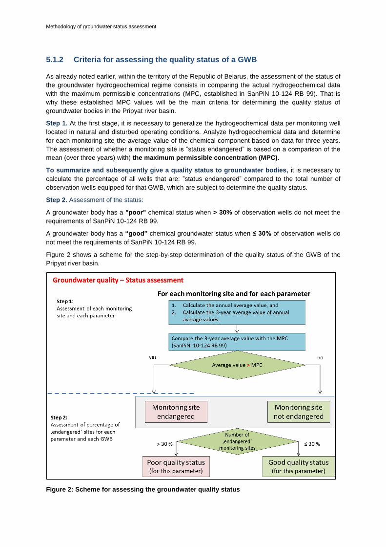
Methodology of groundwater status assessment
5.1.2 Criteria for assessing the quality status of a GWB
As already noted earlier, within the territory of the Republic of Belarus, the assessment of the status of
the groundwater hydrogeochemical regime consists in comparing the actual hydrogeochemical data
with the maximum permissible concentrations (MPC, established in SanPiN 10-124 RB 99). That is
why these established MPC values will be the main criteria for determining the quality status of
groundwater bodies in the Pripyat river basin.
Step 1. At the first stage, it is necessary to generalize the hydrogeochemical data per monitoring well
located in natural and disturbed operating conditions. Analyze hydrogeochemical data and determine
for each monitoring site the average value of the chemical component based on data for three years.
The assessment of whether a monitoring site is “status endangered” is based on a comparison of the
mean (over three years) with) the maximum permissible concentration (MPC).
To summarize and subsequently give a quality status to groundwater bodies, it is necessary to
calculate the percentage of all wells that are: ”status endangered” compared to the total number of
observation wells equipped for that GWB, which are subject to determine the quality status.
Step 2. Assessment of the status:
A groundwater body has a "poor" chemical status when > 30% of observation wells do not meet the
requirements of SanPiN 10-124 RB 99.
A groundwater body has a “good” chemical groundwater status when ≤ 30% of observation wells do
not meet the requirements of SanPiN 10-124 RB 99.
Figure 2 shows a scheme for the step-by-step determination of the quality status of the GWB of the
Pripyat river basin.
Figure 2: Scheme for assessing the groundwater quality status

Methodology of groundwater status assessment
28
5.1.3 Criteria for assessing the quality risk of a GWB
As already noted earlier, within the territory of the Republic of Belarus, the assessment of the risk of
the groundwater hydrogeochemical regime consists in comparing the actual hydrogeochemical data
with the natural background concentrations. That is why these calculated background concentrations
will be the main criteria for determining the quality risk of groundwater bodies in the Pripyat river basin.
Step 1. As for status assessment, in the first stage it is necessary to generalize the hydrogeochemical
data per monitoring well located in natural and disturbed operating conditions. Analyze hydrogeo-
chemical data and determine for each monitoring site the average value of the chemical component
based on data for three years. The assessment of whether a monitoring site is “risk endangered” is
based on a comparison of the mean (over three years) with the background value.
To summarize and subsequently give a quality risk to groundwater bodies, it is necessary to
calculate the percentage of all wells that are ”risk endangered” compared to the total number of obser-
vation wells equipped for that GWB, which are subject to determine the quality status.
Step 2. A groundwater body is “at risk” when, in > 30% of observation wells, polluting components
exceed background values and have a tendency to increase their content.
A groundwater body is “not at risk” when ≤ 30% of observation wells exceed background values.
Step 3: In the case where > 30% of observation wells are ‘risk endangered’, a trend assessment is
necessary to identify the tendency of concentrations to increase.
Figure 3 shows a scheme for the step-by-step determination of the quality risk of the GWB of the Pri-
pyat river basin.
Figure 3: Scheme for assessing the groundwater quality risk

Methodology of groundwater status assessment
5.2 Summary of method requirements and restrictions
To assess the groundwater status both in the territory of the Republic of Belarus as a whole and in the
Pripyat river basin in particular, it would be relevant to determine the “threshold value” and “initial point
for the reverse trend”.
The background of the “threshold value” and “starting point for the trend reversal” is that they can be
used to more flexible approach to groundwater quality management issues. For example [3]: nitrate
values in groundwater are below 45 mg/l (50 mg/l EU quality standard) and nitrates cause eutrophica-
tion in the relevant surface water body, which justifies setting a lower threshold for nitrates. In other
words, if, as a result of deterioration in the groundwater quality (for example: nitrate pollution), the
surface water quality has deteriorated (eutrophication), then using the “threshold value”, the require-
ments for the quality of groundwater can become stricter.
The benefits of a “starting point for trend reversal” is to take measures early enough to prevent
groundwater pollution at the initial stage of its formation.
Naturally, in order to determine the “threshold value” and “starting point for trend reversal” qualified
experts who understand the regional, local features of the geological and hydrogeological conditions
of the Republic of Belarus should be involved; processes (water-rock) occurring as a result of anthro-
pogenic loads, as well as taking into account the peculiarities of the factors of groundwater formation,
etc.

Methodology of groundwater status assessment
30
6 TESTING OF THE PROPOSED
METHODOLOGIES (AT 2 GROUNDWATER
BODIES IN THE PRIPYAT RIVER BASIN)
According to the requirements of the WFD, status assessment should only be carried out for GWBs
that are identified as being at risk. GWBs that are not at risk are automatically classified as having
good status.
In this chapter, the proposed methodology will be tested on the example of two GWBs in the Pripyat
river basin. They include GWB BYPRGW0002 (water-bearing Holocene alluvial, Poozerie alluvial,
Poozerie lacustrine-alluvial aquifer (s)) and BYPRGW0006 (water-bearing Berezina-Dnieper water-
glacial and Paleogene and Neogene complex). These GWBs were chosen because: GWB BY-
PRGW0002 is the first aquifer below the surface, thus it is more exposed to anthropogenic impact;
And GWB BYPRGW0006 is the main exploited aquifer.
6.1 GWB quality status assessment
In order to assess the chemical status of GWB BYPRGW0002 and BYPRGW0006, data obtained as a
result of monitoring observations on natural and disturbed regimes for the period from 2016 to 2018
were used. This period was chosen because it is more comprehensive. The largest number of obser-
vation wells have data for this period of time.
The compound NO3- was chosen as the experimental component (by which the GWP status was de-
termined). This is due to the fact that rather large areas of the Pripyat river basin are used as agricul-
tural land, the effect of which on groundwater can be shown in increased concentrations of NO3- com-
pound. According to the proposed methodology, the status assessment includes:
1. Compilation and generalization of hydrogeochemical data on GWBs BYPRGW0002 and
BYPRGW0006
In order to determine the chemical status of the GWB BYPRGW0002, 13 observation wells were uti-
lized (of which 7 wells in natural conditions and 6 wells in disturbed conditions).
In order to determine the chemical status of the GWB BYPRGW0006, 104 observation wells were
utilized (of which 43 wells in natural conditions and 61 wells in conditions disturbed by the operation).
As a result of aggregation of all hydrochemical data, the dataset for the GWB BYPRGW0002 and BY-
PRGW0006 were compiled.
2. Determination of "average value"
Figure 4 shows a fragment of the dataset with the calculated average values for GWB BYPRGW0006
(disturbed conditions). The same work was performed for the rest of the datasets, including the GWB
BYPRGW0002 for each observation well (natural, disturbed conditions).

Methodology of groundwater status assessment
Figure 4: Determination of the average value according to GWB BYPRGW0006 (disturbed
conditions)
3. Comparison of the “average value” with the background level and MPC
Comparison of the "average value" with background and maximum permissible concentrations was
carried out (established by SanPiN 10-124 RB 99).
The calculation of background concentrations was carried out for hydrogeological posts (natural condi-
tions) located in the territories of forest areas. Average values for each component were calculated
over a period of 5 years.
Table 2 shows the background and maximum permissible concentrations of the NO3- compound for
the GWBs BYPRGW0002 and BYPRGW0006 in the Pripyat river basin.
Table 2: Background concentrations of NO3- component in GWBs BYPRGW0002 and
BYPRGW0006
GWB name Aquifers and complexes Background levels
NO3-, mg/l
MPC NO3
-, mg/l
BYPRGW0002
aIV 1,5
45
aIIIpz 2,4
laIIIpz 1,1
BYPRGW0006
f,lgIbr-IId 2,2
P3+N 1,4
P3hr 1,2
P2kv 1,4
4. Determination of chemical status
As a result of comparing the "average value" for GWB BYPRGW0002 with background concentra-
tions, it was found that out of 7 wells (natural regime) in the 1st well, the average value of NO3- ex-

Methodology of groundwater status assessment
32
ceeds the background concentration. Out of 6 wells in the disturbed regime - in 2 wells, the nitrate
content is higher than the background (Table 3).
GWB BYPRGW0006: out of 43 wells (natural regime) in 8 wells, the average value of NO3- exceeds
the background concentration. In disturbed conditions, out of 61 wells - in 8 wells the nitrate content is
higher than the background, in one - higher than the MPC (Table 3).
Table 3: The number of observation wells in which the nitrate content is above the background
and MPC in the GWBs BYPRGW0002 and BYPRGW0006
GWB
Natural regime Disturbed regime
total wells
above background level
above MPC
total wells
above background level above MPC
BYPRGW0002 7 1 - 6 2 -
BYPRGW0006 43 8 - 61 8 1
One should calculate the percentage of all wells that are: a) above the background level (at risk) b)
above the MPC (poor status) compared to the total number of observation wells equipped for that
GWB, for which it is necessary to determine its qualitative status (Table 4).
Table 4: Determination of the qualitative status of the GWB BYPRGW0002 and BYPRGW0006
GWB name GWB area total wells
above background level
above MPC
background level percentage
MPC percentage
GWB status
BYPRGW0002 14254.25 13 3 - 23% - at risk
BYPRGW0006 39879.46 104 16 1 15.40% 0.96% good
On the basis of the results obtained and according to the presented methodology, it was determined
that the qualitative status of the GWB BYPRGW0002 is "good", since the percentage was <30%, no
excess of the MPC was identified.
Good status has been identified for GWB BYPRGW0006. Here, the percentage of background and
MPC was <30%.
In terms of GWB BYPRGW0002, such a methodological approach is likely to be premature. This is
primarily due to the fact that on the territory of 14254.25 km2 (area of the GWB BYPRGW0002), ob-
servations of the hydrogeochemical regime are carried out only in 13 wells.
It should be also taken into account that the peculiarities of geological and hydrogeological conditions
(the aquifer is poorly protected from surface pollution), anthropogenic load (large areas are occupied
by agricultural land). In the light of information, we believe that it is necessary to assign this GWB the
status "at risk", with recommendations aimed at developing the regime well network for this GWB.
6.2 GWB quantity status assessment
To assess the quantitative status of GWBs BYPRGW0002 and BYPRGW0006, data obtained as a
result of monitoring observations on natural and disturbed regimes were used. The interpretation of
the data on the hydrodynamic regime was conducted over the last 10 years of observations (com-
pared with the initial year of the analyzed 10-year period).
According to the proposed method, the assessment of the hydrodynamic status of the GWB BY-
PRGW0002 was carried out with the use of observation wells located in natural conditions and obser-

Methodology of groundwater status assessment
vation wells located at the edges of the water intake and equipped on the overlying, not exploited aqui-
fers.
According to the proposed method, the assessment of the hydrodynamic status of the GWB BY-
PRGW0006 was conducted for observation wells located in natural conditions and observation wells
equipped for the exploited aquifer (complex).
In accordance with the proposed methodology, the status assessment will include:
1. Compilation and generalization of hydrodynamic data for the GWBs BYPRGW0002 and
BYPRGW0006;
In order to determine the quantitative status of the GWB BYPRGW0002, 4 hydrogeological stations
were utilized, which include 8 observation wells (natural regime) and 2 observation wells located at the
Lesnoy water intake in Kalinkovichi (well 1 is located in the central part of the water intake, well 3 - 0.5
km from its center).
In order to determine the quantitative status of the GWB BYPRGW0006, 21 hydrogeological posts (42
observation wells of natural regime) and 23 observation wells are utilized, located on the main produc-
tion aquifer (Table 5). As a result of aggregation of all hydrodynamic data, datasets for GWBs BY-
PRGW0002 and BYPRGW0006 were compiled.
Table 5: The number of observation wells for which the hydrodynamic information processing
was performed according to the GWBs BYPRGW0002 and BYPRGW0006
GWB Number of observation wells
Natural regime Disturbed regime
BYPRGW0002 8 2
BYPRGW0006 42 23
2. Determination of “decrease”. Comparison Sact. and Sper.;
GWB BYPRGW0002. As a result of the performed data processing, it was determined that over a ten-
year period, the course of levels the GWB BYPRGW0002 in natural conditions had a negative trend,
however, the decrease in the levels (compared to the initial year of the analyzed 10-year period) cor-
responded to natural fluctuations and ranged from 0.25 to 0.64 m.
As a result of the performed data processing, it was determined that over a ten-year period of time, the
maximum decrease in the level (in comparison with the initial year of the analyzed 10-year period)
under disturbed operating conditions was 0.53 m in 2015, when the amount of water withdrawal was
maximum.
GWB BYPRGW0006. As a result of the performed data processing, it was determined that over a ten-
year period of time, the course of the levels of the GWB BYPRGW0006 in natural conditions had a
negative trend, however, the decrease in levels (compared to the initial year of the analyzed 10-year
period) corresponded to natural fluctuations and ranged from 0.08 to 1 m.
Water withdrawal from GWB BYPRGW0006 was carried out only at water intakes Lesnoy-1, Go-
rodskoy (Kalinkovichi) and Luchezhevichi (Mozyr). The observations for the groundwater levels of the
BYPRGW0006 water body at the water intakes Lesnoy-1 and Gorodskoy (Kalinkovichi) were carried
out at 11 observation wells.
The analysis of actual data and graphic material showed that at the water intakes of Lesnoy-1 and
Gorodskoy in the exploited aquifer in the central part of the water intake in well 2, the absolute marks
of groundwater levels ranged from 119.9 m in 2015 with a maximum water withdrawal of 9.3 thousand
m3/day up to 121.5 m in 2017 with a water withdrawal of 8.04 thousand m
3/day. The maximum level
decrease from the initial level in the central part was 2.45 m (well 2) and was noted in 2015.

Methodology of groundwater status assessment
34
In observation wells at the water intake Lesnoy-1, located at distances of 0.6 km (well No. 5) and 1.1
km (well No. 6) from the center, the magnitudes of decreases are 2.22 m and 0.33 m, respectively.
The wells at the Gorodskoy water intake, located outside the depression zone (at a distance of 4-8.6
km from the water intake center), the levels decreases was practically not recorded. The permissible
decrease, calculated when assessing the operational reserves at these water intakes reached 55 m. It
significantly exceeds the actual ones (Table 6).
Table 6: Maximum level decrease in exploited aquifers at operating water intakes over a 10-
year observation period
City Water intake
Well code
Exploited aquifer index
Distance from center of water intake, km
Maximum level decrease in the center S, m
year Q 1000 m
3/day
Permissible decrease, m
2 3 4 5 6 7 8 9 10
Kalinkovichi
Lesnoy-1
4 f,lgIbr-IId 0.6 1.19
2015 9.3 55.0
2 Pkn-hr center 2.45
5 Pkn-hr 0.6 2.22
6 Pkn-hr 1.1 0.33
7 Pkn-hr 2.5 +0.12
8 Pkn-hr 1.0 2.6
Gorodskoy
20 f,lgIbr-IId 2.5 1.83
1 Pkn-hr 2.0 0.63
3 Pkn-hr 4.0 0.3
6 Pkn-hr 8.6 0.19
7 Pkn-hr 6.0 +0.33
Mozyr Luchezhevichi
3701 f,lgIbr-IId 1.7 no data
2009 40.8 37.0
3702 f,lgIbr-IId 0.7 no data
3703 f,lgIbr-IId center no data
3704 f,lgIbr-IId 2.1 no data
3705 f,lgIbr-IId 2.5 no data
701 P+Q 1.7 2.08
702 P+Q 0.7 3.84
703 P+Q center 6.49
704 P+Q 2.1 0.69
705 P+Q 2.5 +0.31
2702 P2kv 0.7 no data
2703 P2kv center no data
On the basis of the analysis of groundwater level observations of the exploited aquifer system in re-
gime wells in the area of water intakes of Kalinkovichi, the radius of the depression funnel along the
isoline of a decrease of 1 m during the ten-year observation period did not exceed 2.5-3.0 km.
At the Luchezhevichi water intake, monitoring the levels of the water body BYPRGW0006 during
2009–2018 were carried out in 12 wells located at different distances from the center.
In the exploited joint water-bearing Quaternary water-glacial and Paleogene terrigenous complex, the
absolute marks of groundwater levels in the central part of the water intake in well 703 varied from
112.8 m in 2009 with the highest water withdrawal of 40.8 thousand m3/day to 114.27 m with its mini-
mum value of 21.7 thousand m3/day in 2018. The maximum groundwater level decrease in the center

Methodology of groundwater status assessment
of the water intake over the 10-year observation period was 6.49 m (well 703). Decreases in levels in
observation wells located at distances from 0.7 km (well 702) to 2.5 km (well No. 705) in the same
time period reached 3.84 and 0.31 m. In wells located near the Pripyat river (wells 705, 3705, 704 and
3704) fluctuations in the GWB BYPRGW0006 are greatly impacted by the hydrological regime of the
Pripyat river, and the impact of water withdrawal practically does not affect.
The permissible decrease, calculated when assessing the exploitation of reserves at the water intake
reached 37 m. And it significantly exceeds the actual ones.
3. Quantitative status determination.
On the basis of the generalization of hydrodynamic data on the natural and disturbed regimes, we will
determine the status of the GWB BYPRGW0002 and BYPRGW0006.
The maximum decrease of the GWB BYPRGW0002 in natural conditions reached 0.64 m and 0.53 m
under disturbed operating conditions with the maximum water withdrawal in 2015. The obtained max-
imum decrease naturally does not exceed 1 meter, thus the quantitative status of the GWB BY-
PRGW0002 is “good”.
The maximum decrease of the GWB BYPRGW0006 in natural conditions reached 1 m (in 2 wells).
Under disturbed operating conditions, the maximum actual decreases were 2.45 and 6.49 m, which
did not exceed the permissible level: 55 and 37 m, respectively (Table 6), thus the quantitative status
of the GWB BYPRGW0006 is “good”.
On the basis of the research performed, it was established that with all available calculations, the qual-
itative status of the GWB BYPRGW0002 should be kept “at risk” in order to further develop the regime
network of wells for this aquifer. The quantitative status of the GWB BYPRGW0002 is “good”.
The qualitative and quantitative statuses of the GWB BYPRGW0006 are"good".
It should be noted that the proposed methodology will be gradually improved and elaborated as the
issues concerning the development of the regime network of wells (for example: uneven distribution
and insufficient number of observation wells, lack of coordinates of observation wells, etc.); the im-
provement of the database "Groundwater in the Republic of Belarus" (for example: transfer to GIS
technology, conducting integrated groundwater monitoring); creating mathematical models, calculating
balances, etc.
Despite the existing limitations, we have performed a huge amount of work, which consisted in com-
paring the methods of groundwater monitoring in accordance with the requirements of the WFD and
the legislation of the Republic of Belarus; establishment of criteria for determining the GWB status of
the Pripyat river basin; development of methodology and its approbation on real hydrochemical and
hydrodynamic data.
6.3 Summary of groundwater status assessments and
conclusions
On the basis of the research carried out, it was established that with all available calculations, the
qualitative status of the GWB BYPRGW0002 should be kept "at risk" in order to further develop the
regime network of wells for this aquifer. The quantitative status of the GWB BYPRGW0002 is “good”.
The qualitative and quantitative status of the GWB BYPRGW0006 is “good”.
It should be noted that the proposed methodology will be gradually improved and elaborated as the
issues concerning: development of the regime network of wells (for example: uneven distribution and
insufficient number of observation wells, lack of coordinates of observation wells, etc.); improvement of
the database "Groundwater of the Republic of Belarus" (for example: transition to GIS technology,
conducting integrated monitoring of groundwater); creating mathematical models, calculating balanc-
es, etc.

Methodology of groundwater status assessment
36
Despite the existing limitations, a lot of work was done, which consisted in comparing the methods of
groundwater monitoring in accordance with the requirements of the WFD and the legislation of the
Republic of Belarus; establishment of criteria for determining the GWB status of the Pripyat river basin;
development of a methodology and its approbation on real hydrochemical and hydrodynamic data.

Methodology of groundwater status assessment
7 SUMMARY OF OPEN ISSUES AND MISSING
DATA
In the period from 2018 to 2020, under the International Program " European Union Water Initiative
plus for the Eastern Partnership countries" (EUWI+) and with the joint participation of Belarusian,
Ukrainian and Austrian experts-hydrogeologists, a number of pilot projects were carried out, the main
goal of which was to support the state management in the implementation of the principles of the Wa-
ter Framework Directive (WFD) with the subsequent development of the Pripyat River Basin Manage-
ment Plan.
In this chapter, the authors have collected and summarized all open issues and gaps that were identi-
fied during the implementation of pilot projects (from 2018 to 2020) in the Pripyat river basin. It should
be noted that most of the presented issues are relevant not only for the Pripyat river basin, but also for
the entire groundwater monitoring system of the Republic of Belarus. The gradual elimination of these
issues will allow to improve the methodological approaches and the groundwater monitoring system,
on the basis of which the assessment of the state of groundwater in the Pripyat river basin is carried
out in order to make quick and high-quality management decisions both in the country and abroad (in
terms of international relations).
For this, first of all, it is necessary to work out the issues related to the development and optimization
of the regime well network in the Pripyat river basin, including the development of transboundary
groundwater monitoring in the Republic of Belarus and Ukraine, solving problems of scientific and
regulatory legal focus. The main ones include:
7.1 Development of a regime network of observational wells in
the Pripyat river basin:
1.1 To include the regime network of observational wells developed and equipped in 2019 at the GWB
BYPRGW0001 in the list of observation points for the groundwater state of the National Groundwater
Monitoring System of the Republic of Belarus, and to continue observations on it;
1.2 To include observational wells of the Lomachi hydrogeological station and the regime well network,
equipped in the 80-90s for state monitoring of groundwater subjected to radionuclide contamination in
the National Groundwater Monitoring System of the Republic of Belarus;
1.3 To conduct additional survey (to find and survey the technical condition of single wells, perform
their testing) of those sections of the Pripyat river basin, which are not covered by observational wells
for groundwater monitoring. If they are absent, drill new ones;
1.4 To perform coordinate referencing of all wells included in the regime observational network (natu-
ral (low-disturbed), disturbed by operation conditions);
1.5 To optimize the regime network of wells in order to distribute them evenly within the boundaries of
each GWB, since (as can be seen from the Table 7) there is clearly not enough observational wells to
monitor the state of the GWB for some water bodies;
1.6 To equip with automatic level gauges the observational wells that will be included in the regime
network for groundwater monitoring in the transboundary territory of the Pripyat river basin;
1.7 It is proposed to include 22 new observation sites. Within the boundaries of distribution of the
GWBs BYPRGW0001, BYPRGW0002, BYPRGW0003, BYPRGW0004 and BYPRGW0009, we pro-
pose to drill 12 new wells (Table 8 and Table 9).

Methodology of groundwater status assessment
38
Table 7: Number of observational wells and site density of the GWBs of the Pripyat river basin
GWB code GWB area, [km
2]
Number of observational wells (both operating and abandoned)
Number of operating wells
Number of wells per 1000 km
2
Quaternary deposits
BYPRGW0001 13,431.09 15 15 1.12
BYPRGW0002 15,522.56 24 13 1.55
BYPRGW0003 13,470.77 13 4 0.97
BYPRGW0004 11,333.91 42 30 3.71
BYPRGW0005 9,821.77 13 6 1.32
Total: 107 68
Pre-Quaternary deposits
BYPRGW0006 45,678.55 148 121 3.24
BYPRGW0007 27,515.15 29 20 1.05
BYPRGW0008 2,444.55 18 17 7.36
BYPRGW0009 23,738.88 92 72 3.88
BYPRGW0010 108.52 н.с. н.с. -
BYPRGW0011 1,404.03 н.с. н.с. -
Total: 287 230 -
Total: 394 298 -
Table 8: Suggestions for inclusion of existing observation points of the groundwater
monitoring network in the Pripyat river basin
GWB code Monitoring network suggestions
BYPRGW0001 To continue monitoring at 13 wells equipped in 2019.
BYPRGW0002 To continue monitoring at 8 operating wells in natural conditions (5 hydrogeological stations) and 2 wells in the Lesnoy water intake. Also, to continue monitoring on 3 wells surveyed in 2019.
BYPRGW0003 To continue monitoring at 3 operating wells in natural conditions (3 hydrogeological stations) and 4 wells in the Ostrovy water intake. Also, to continue monitoring at 1 well surveyed in 2019.
BYPRGW0004 To continue monitoring at 3 operating wells in natural conditions (3 hydrogeological stations) and 27 wells in the Ostrovy water intake.
BYPRGW0005 To continue monitoring at 5 operating wells in natural conditions (3 hydrogeological stations) and resume monitoring at the abandoned well 706 (Luchezhevichi water intake). Also, to continue monitoring at 1 well surveyed in 2019.
BYPRGW0006 To continue monitoring at 42 operating wells in natural conditions (21 hydrogeological stations) and 79 wells at 7 water intakes. Rotation is recommended at least for 20 wells.
BYPRGW0007 To continue monitoring at 4 operating wells in natural conditions (4 hydrogeological stations) and 16 wells in water intakes.
BYPRGW0008 To continue monitoring at 2 operating wells in natural conditions (1 hydrogeological station) and 15 wells in water intakes.
BYPRGW0009 To continue monitoring at 3 operating wells in natural conditions (2 hydrogeological stations) and 67 wells in water intakes.
BYPRGW0010 No suggestions
BYPRGW0011 No suggestions

Methodology of groundwater status assessment
Table 9: Suggestions for improvement and equipment of new observation points of the
groundwater monitoring network in the Pripyat river basin
GWB code Monitoring network suggestions
BYPRGW0001 To drill 2 new observational wells in the western and eastern parts of the Pripyat river basin. To include 13 wells equipped in 2019 in the regime observation network.
BYPRGW0002 To drill 4 new observation wells in the transboundary area. To include 3 wells surveyed in 2019 in the regime observation network. To recommend 2 sites for additional survey
BYPRGW0003 To drill 2 new observation wells. To include 1 well surveyed in 2019 in the regime observation network. To recommend 3 sites for additional survey.
BYPRGW0004 To drill 2 new observation wells. To recommend 5 sites for additional survey.
BYPRGW0005 To recommend 5 sites for additional survey due to the lack of information about single wells, water intakes and wells located at local sources of groundwater pollution.
BYPRGW0006 To include in the regime network and resume observations on 2 wells of the conserved Lomachi hydrogeological station, surveyed in 2019
BYPRGW0007 To include in the regime network and resume observations on 1 well of the conserved Lomachi hydrogeological station, surveyed in 2019
BYPRGW0008 To continue groundwater monitoring on the existing regime well network
BYPRGW0009 To drill 2 new observation wells. To include 2 operating wells of Pina-2 water intake surveyed in 2019 in the annual analysis of groundwater monitoring
BYPRGW0010 No suggestions
BYPRGW0011 No suggestions
7.2 Transboundary groundwater monitoring of the Republic of
Belarus and Ukraine
2.1 To determine the list of groundwater monitoring points for water bodies within the borders of trans-
boundary corridors from the Ukrainian side;
2.2 To unify hydrogeological legends for the transboundary territories of the Republic of Belarus and
Ukraine;
2.3 To make a map with the suggested sites for groundwater monitoring for each water body from both
the Belarusian and Ukrainian sides for their subsequent inclusion in the program of transboundary
groundwater monitoring;
2.4 To develop a joint transboundary groundwater monitoring program for the territories of the Repub-
lic of Belarus and Ukraine with the purpose of integrated joint management of transboundary water
resources;
2.5 To provide implementation of pilot projects that will be aimed at obtaining additional hydrodynamic
and hydrogeochemical information, focusing on the transboundary aspect.

Methodology of groundwater status assessment
40
7.3 Scientific aspects
3.1 To determine the quantitative and qualitative status of groundwater, it is necessary to carry out a
geological and ecological assessment of state of the GWBs in the south-east of the Pripyat river basin,
namely: to build / draw up maps of natural protection of the GWBs and anthropogenic load in the
south-east of the Pripyat river basin with application of hydro-geochemical information;
3.2 To conduct a comprehensive assessment of groundwater bodies and associated surface water or
terrestrial ecosystems, which at this stage was impossible due to the lack or unavailability of infor-
mation;
3.3 For a comprehensive analysis and assessment of state of the GWBs in the Pripyat river basin, the
IAC GM shall provide access to information on pollution sources (local sources of pollution) of
groundwater;
3.4 To convert / transform step by step all geological and hydrogeological, hydrodynamic and hydro-
geochemical, coordinate, etc. information on groundwater in the territory of the Pripyat river basin to
GIS;
3.5 To improve statistical approaches to assessing monitoring information in order to obtain more de-
tailed and more demonstrative conclusions;
3.6 For the final study of the transboundary territory of the Republic of Belarus and Ukraine, it is nec-
essary to provide implementation of pilot projects in the part of the Western Bug (Zakhodni Buh) river
basin;
3.7 The issue of restoration and research work within the balance areas, which were located in the
Pripyat river basin as well, remains open and currently relevant (climate change issues);
3.8 To provide research work on determining threshold values and starting points for reverse trend.
7.4 Regulatory legal objectives
4.1 To provide possibility of developing a regulatory document that would make it possible to legisla-
tively improve the conduct of groundwater monitoring in such a way, that all organizations that have
information regarding groundwater / groundwater monitoring would transfer it in accordance with the
established procedure to the IAC GM of the State Enterprise "Scientific Research Center for Geology",
branch "Institute of Geology" for its storage in the database "Groundwater of the Republic of Belarus"
and its use in order to generalize the material and comprehensively assess state of groundwater both
in the Pripyat river basin and the entire territory of the Republic of Belarus
Solution of the above tasks will improve the methodological approaches to groundwater monitoring,
will make it possible to comprehensively assess state of the GWBs in the territory of the Republic of
Belarus, and after that it will be possible to talk about the integrated management of water resources,
decision-making in terms of preserving resources and groundwater reserves, their protection from
pollution.

Methodology of groundwater status assessment
8 CONCLUSIONS AND RESULTS
To develop a methodology for determining status of the GWBs of the Pripyat river basin the following
studies were performed:
The regulatory legal and methodological documents of the European Union and the Republic of Bela-
rus have been worked out. As a result of their analysis and comparison, the following was determined:
one of the directions of the EU groundwater monitoring concept is not only the protection of groundwa-
ter from pollution and depletion, but also the protection of ecosystems that directly or indirectly depend
on the state of groundwater. It is also important that the EU WFD groundwater monitoring system is
not based on the analysis of a single point (well), but is aimed at analyzing and understanding the
operation of the entire hydrogeological system, which is especially important for a comprehensive
assessment of the state of groundwater and its protection from pollution and depletion.
Some EU methodologies for assessing the quantity and quality of GWBs are considered, in which the
WFD recommends measuring the following to assess the quantity of groundwater: the level of
groundwater in wells or springs; flow rate of springs; runoff characteristics and/or levels of surface
watercourses during the dry season; water levels in wetlands and lakes, significantly dependent on
groundwater, which is also relevant for the Republic of Belarus. Also, in order to determine the overall
quantitative status of the GWB, a series of tests is applied to consider the impact of anthropogenic
changes on groundwater levels and/or discharge. Each test assesses whether the GWB meets envi-
ronmental objectives.
To assess the quality of the GWB, it is quite interesting to use concepts such as “threshold value” and
“starting point for the reverse trend”, which would be useful for assessing the quality of groundwater in
the Republic of Belarus.
Criteria have been determined and a methodology has been proposed for assessing the GWB status
of the Republic of Belarus, in general, and the Pripyat river basin, in particular. As a result, a prelimi-
nary assessment of the status of each GWB of the Pripyat river basin was made (according to the
principle: “good”, “under risk”, “poor”).
On the basis of the previous and present studies, proposals were given for the development of a na-
tional and transboundary regime network of observational wells in the Pripyat river basin; the tasks of
scientific and regulatory legal orientation were listed, the solution of which will make it possible to in-
troduce new approaches to groundwater monitoring and comprehensively assess the state of the
GWBs in the territory of the Republic of Belarus.

Methodology of groundwater status assessment
42
9 REFERENCES
1. Directive 2000/60/EC of the European Parliament and of the Council of October 23, 2000;
2. "INSTRUCTIONS on the local environmental monitoring procedure for legal entities carrying out
economic and other activities that have a harmful effect on the environment, including environmentally
hazardous activities." Approved by the Resolution of the Ministry of Natural Resources and Environ-
mental Protection of the Republic of Belarus No. 9 on February 01, 2007 (as amended by the Resolu-
tion of the Ministry of Natural Resources and Environmental Protection of the Republic of Belarus No.
4 on January 11, 2017);
3. Common Implementation strategy for the Water Framework Directive (2000/60/EC). Guideline No.
18 Guidelines on groundwater status and trend assessment;
4. Sanitary rules and regulations SanPiN 10-124 RB 99 2.1.4. “Potable water and water supply of resi-
dential areas. Hygienic requirements and quality control of potable water quality in centralized potable
water supply systems. Mn., 1999;
5. https://docplayer.ru/29375121-Vodnaya-strategiya-respubliki-belarus-na-period-do-2020-goda.html;
6. http://kodeksy-by.com/vodnyj_kodeks_rb.htm;
7. http://gost.gtsever.ru/Index2/1/4293828/4293828719.htm;
8. http://blacksea-riverbasins.net/ru/молдова


www.euwipluseast.eu