Embed Size (px)
Citation preview

EKOLÓGIA (BRATISLAVA) VOL. 24, SUPPLEMENT 1/2005, P.
NATURA 2000 HABITAT MAPPING IN THE CZECH REPUBLIC: METHODS AND
GENERAL RESULTS
JIŘÍ GUTH1, TOMÁŠ KUČERA2
1Ministry of Environment, Vršovická 65, 100 10 Praha 3. The Czech Republic, e-mail:
[email protected] 2Institute of Systems Biology and Ecology, Academy of Sciences CR, Na Sádkách 7, 370 05
České Budějovice. The Czech Republic, e-mail: [email protected]
Abstract
Guth J., Kučera T.: NATURA 2000 habitat mapping in the Czech Republic: methods and general results.
Ekológia (Bratislava), Vol. 24, Supplement 1/2005, p.
Natura 2000 is the most important European biotope compound network, that has been established for
comprehensive nature conservation and habitat protection. This system consist of two major streams: (i) Special
Protection Areas, SPA, cover areas according the Birds Directive, (ii) Special Areas of Conservation (SAC) cover
the land reserves according the Habitats Directive. The Habitats Directive Annex 1. habitats (Natura 2000
habitats) have been interpreted by the national system of biotopes in the Czech Republic. The most extensive field
habitat mapping covering the entire Czech Republic in the fine-scale 1:10.000 has been finished in 2004. In
Central Europe this is an absolutely unique approach, that has resulted to the largest actual database about nature.
The paper covers the methodological approach of habitat mapping, and the general results (biotope types in
601960 segments, 9383.7 km2).
Key words: Natura 2000 habitats, habitat mapping, GIS
Introduction
The most important European act for protection of endangered species and their natural
habitats is surely the Habitats Directive (92/43/EEC), enacted since 21 May 1992. The general
objective of this guideline is the establishment of Natura 2000 network of sites/reserves. The
synoptic system of natural habitats was established for the member states of the European
Community (European Commission, 1999). In Eastern Europe this system of habitats was
enlarged, and especially was focused on the local (endemic) habitats (European Commission,
2003). The classification of habitats was established on the base of CORINE-Biotopes
typology (Devillers et al., 1991), and therefore it was not originated as strictly hierarchical
classification. The national interpretation of Natura 2000 habitats for the Czech Republic has
been prepared, and the new national typology of biotopes, usually sub-types of habitats sensu
Habitats Directive, was discovered (Chytrý et al., 2001). Similar national interpretation of
habitats was prepared also in Slovakia (Stanová, Valachovič, 2002), methodology and general
results were published by Šeffer, Lesák (2004).
The major critical step was the field habitat mapping of all natural habitats into the map
with enough fine-scale resolution. It was necessary to collate large amount of field data of all
biotopes, mainly about their distribution, spatial dimensions, and qualities. This map layer
generally improve the process of preparation and building of Natura 2000 networks, esp. an
exact definition of SAC areas, directions of borders, inventory of localities, and evaluation of
their habitat quality, etc. Also the endangerment value, general statistics, and threatened plant
and animal species occuring in habitats/biotopes have been described in check list (Kučera
2005).
Some new applications have been actually finished, based on the biotopes mapping.
Detailed analysis of distribution of scree habitats in the Czech Republic was reported by
Zacharda, Boucníková, 2006. The GIS biotopes layer should be used as strong power tool for
the exact spatial specification of financial evaluation of nature, esp. in small sized areas
(Cudlín et al., 2006). The biotopes mapping can also help with the interpretation of CORINE
Land cover changes. Boucníková, Kučera, 2006 have distinguished the degradation of natural
biotopes in coincidence of land cover changes over the last 15 years. All these examples show
the high potential of biotopes/habitats mapping for nature conservation and biodiversity
oriented landscape planning.
Methodology

There are two levels of biotopes mapping. The main aim of (i) the detailed biotopes mapping
was to discover all biotopes (which means natural ones as well as so called anthropogenic
biotopes) in natural areas, and to collect all the characteristics such as representativity,
conservation status, and so on. In contrast, the general aim of (ii) the contextual biotopes
mapping was to find out occurrences and dimensions of all natural biotopes on the whole
territory of the Czech Republic, moreover to select advisable areas for detailed mapping.
Detailed biotopes mapping was made only on pre-selected areas which are supposed to
contain major or high proportion of natural and seminatural biotopes. Contextual mapping
serves to complete detailed mapping whenever there is yet any assumption of natural biotopes
occurrence. Particularly some sites were not mapped at least; such as large areas devastated by
mining, agriculture and forestry areas without any natural values, and continuously built-up
and otherwise urbanized areas, mainly inner sites of settlements, etc. (Fig. 1).
Determination of biotopes
Primary the physiognomical vegetation approach was recommended for the biotopes
determination , secondly the ecological, and at least the floristic ones were used. The highest
accent was put on the diagnostic species and later on the dominant species. Determination of
vegetation as impartible constituent of concrete biotope does not depend only on the presence
of all diagnostic species sensu Chytrý et al. (2001). Vegetation that resembles more than one
biotope was assigned to the most similar one, but the level of representativity has been lowered
(see later). For the best filing of such vegetation it was necessary to take account of habitat
characteristics and the proportion of occurred diagnostic species. If nor physiognomy neither
species diversity had indicated any natural biotope, the vegetation was classified as an
appropriate type of form group X (anthropogenic habitats). Dots and lines were mapped in
selected natural biotopes in particular. With respect to unnatural biotopes dot and line segments
are registered only in reasonable cases when it could have protecting importance for
conservation of adjacent natural biotopes.
Aggregation of dot segments or small polygons was mapped as one polygonal “mosaic”
segment. Also two parallel line biotopes, however different in their physiognomy and ecology,
were allowed to be mapped as mosaic segment. The mosaics usually consist of two or

exceptionally more components; minor components without any conservation value should be
excluded. Mosaic parts always created different biotopes, not single biotope of several
representativity classes (if there is biotope with different levels of representativity, it is
necessary to “average” the levels). Artificial borderlines should be delineated within area
overlay of two mosaic components which are adjacent in a locality.
Estimation of age structure
The quality of forest stands was evaluated by the age and/or spatial structure of tree layer: (1)
heterogeneous stands of age, where age structure is similar to natural state (P), (2)
semidifferentiated stands, where a major group of the same age (of plantation origin) is
completed by other trees of quite variant age range (Q); also even-aged stands which are little
more differentiated, low structured or composed of disconnected lower storey, (3) age
heterogeneous mosaics of several even-aged stands which are different from each other (such
as gaps, etc. – this fact should be comment in the remarks) (R), and (4) age homogeneous
stands (S).
Degree of representativity
Representativity degree gives a measure of 'how typical' is a habitat type in the segment due to
its definition in Catalogue (Chytrý et al., 2001). While assessing the representativity transition
or even prompt of transition to another mapped unit (esp. occurrence of diagnostic species of
different unit) have to be noticed. The following degrees of representativity are defined:
A –vegetation fully corresponds with the description from the viewpoint of physiognomy,
presence of diagnostic species, ecological conditions, and other characteristics
B – level of representativity is lowered by degradation or occurrence on the edge of the area of
natural distribution) or the vegetation tends to belong to another unit
C – as B in the stronger manner
D –vegetation is not typical particularly because of high degradation, moreover because of
plentiful occurrence of invasive, expansive and other non native species, and other negative
influences disturbing ecosystem structure and function.

In fact, this parameter given wider information, not only the level of anthropogenic
degradation of biotope, but also the level of depletion, which does not have to be caused by
biotope degradation (geographically distant or marginal area of natural distribution, when its
classification is evident, nevertheless, some characteristic species are absent). It can also
improve an information about the fact that the locality has converted into the different natural
biotopes under the external influences. Unusual ecological variability of ecotope can act as
another additional factor.
Estimation of conservation status
Conservation status shows qualitative value of natural biotopes from the conservation
management point of view. Reasons of lowered conservation status can be, for example, the
occurrence of invasive and expansive species, disturbance of water regime, inappropriate way
of farming, or in contrary, absence of suitable way of farming – in consequences it can be
detected by lower number of characteristic species. Each type of vegetation is influenced by
the same factors that can lower the conservation status. Deteriorating factor of one vegetation
type can be crucial for an another type. It is important to consider this particularly for
succession series.
First of all, contemporary conservation status was considered. If it is not optimal (as for
saturation level of diagnostic species and area conditions), future outlooks (for the recorded
biotope!) are valued. In case these “future outlooks” do not correspond with desired evolution
(in direction of the status described in Catalogue), possibilities and demands of contingent
restoration via directed care (conservation management) are considered. Short-term prospect is
taken in years, medium-term prospect in tens of years and long-term prospect happens in more
than a hundred of years. The statement of individual subcriteria is made in order (1) present
status, then (2) outlooks and in the end (3) restoration possibilities (Table 1). Levels of
conservation status A, B, C are resulted by combination of three subcriteria portion.
Present status: A – excellent (optimal status from nature-conservation point of view; it
corresponds with the original description while taking account of present level of
representativity), B – good (satisfactory), C – adverse (serious doubts whether to map the
segment as natural biotope at all or as an area of form group X).

Outlooks (presumptions of next development without any care or other interferences): A –
excellent (stabilization or improvement of state in short-term or medium-term prospect,
negligible risk of deterioration from outside), B – good, C – adverse (threat of state
deterioration in short-, medium- or long-term prospects; high risk of outside impacts).
Restoration possibility: A – accessible and effective (by known methods and available
means), B – objectively possible (higher effort is to be expended), C – difficult (very long-term
prospect or financially and technically exacting management).
As about meadows, ponds and other biotopes which are obviously or directly based on
continuation of human influences, it is only exceptionally possible to mark the biotope in a
“good” state as the biotope with “excellent” outlooks. Outlooks are usually said to be “good”
in situations when there is obvious continuation of contemporary state (common way of
farming) and when a wide range of outside bed influences is not considered.
Phytosociological relevés of selected area and natural biotopes were made because of two
reasons: 1) needfull documentation of biotope occurrence, 2) troubled, temporary or
insufficiently developed vegetation. The relevé had to be taken if new biotope type is
“discovered”, i.e., its occurrence was not drawn down in the concrete square of network
mapping or adjoining squares and when its occurrence is not even supposed (both red and pink
dots in Catalogue maps, respectivelly).
Data processing
Segment characteristics were processed into database (DBF format) using the input programme
NDS (Agency for Nature Conservation and Landscape Protection of the Czech Republic, 2001-
2003). Database structure is common for detailed and contextual mapping. Specification of
database fields (see Table 2) focuse the information about mapping type (detailed or context),
biotope code according Catalogue, segment order number, shape (polygon, line or dot), spatial
dimensions, homogeneity (simple structure or mosaic), age structure of forest (P, Q, R, S),
representativity of given natural biotope segment (from A to D), conservation status (from A
to C) and finally a remark (with list of dominant species, occurrence of invasive or expansive
species, vegetation classification to forms or higher phytosociological units – usually alliances,
human impacts, occurrence of threatened or especially protected or other eminent plant

species, and other information which help to describe segment such as specific physiognomy,
biotope intra-segment variability, etc.).
Report should include (a) basic identification and quantitative data, (b) enumeration and
description of mapped biotopes, and (c) landscape characteristics, such as –brief description of
relief and note on geology and other abiotic characteristics (as for climate etc.). Moreover there
should be a paragraph about potencial vegetation (Mikyška, 1968-1972 and/or Neuhäuslová,
Moravec, 1997; Neuhäuslová et al., 1998), phytogeographical classification and (d) description
of influences and activities in mapped area, and its direct surroundings – list of activities and
their codes as shown in the standard data form according to decision 97/266/ES, (e) occurrence
of important vascular plants - taxa from reduced version of Black and Red List of Vascular
Plants in the Czech Republic, (Holub, Procházka, 2000, Procházka, 2001), occurrence of alien
plants (Pyšek et al., 2002), (f) vulnerability, (g) documentation, (h) phytosociological relevés in
standard format and content e.g. according to Moravec et al., 1994.
Results
Although the comprehensive analyses should be made on the layer of biotopes mapping in GIS
consequently, we present some preliminary results that could be concluded simply from the
general statistics table (see Table 3).
The total number of described segments of all natural and seminatural biotopes was
1 143 104 that cover the area of 20 766 km2. The total database is larger than 1.8 GB. The
Natura 2000 habitats cover nearly half of all biotopes segments, that have been mapped, in
concrete 601 960 segments (52%) covering 9383.7 km2 (45%). As for the area of occurrence,
the rarest biotopes are i) still waters with Aldrovanda vesiculosa, ii) annual halophilous
grasses, iii) Prunus tenella thickets and iv) Salix lapponum subalpine scrub. On the other hand,
the largest biotopes are mesic Arrhenatherum meadows, beech forests (both herb-rich Eu-
Fagenion and acidophilous Luzulo-Fagion) and Hercynian oak-hornbeam forests. As for the
number of localities, there are very rare also i) natural lakes with Isoëtes stands (in the Šumava
Mts), ii) Cladium mariscus dominated fens and iii) cliff vegetation in the Sudeten cirques,
while to those mostly frequent ones belonging to mesophilous shrubs, streamline ash-alder
alluvial forests and wet Cirsium meadows.

Almost one third of forested area in the CR has been recorded as “natural” – in total, 781
446 ha, i.e. ca 29.,5%. Some habitats of “priority” importance for the EU could be considered
common in the CR (e.g. 6230 – Species-rich Nardus grasslands, 9180 – Tilio-Acerion forests,
and 91E0 – Ash-alder alluvial forests). Willow-poplar forests of lowland rivers seem to be
significantly more fragmented and human-influenced then the hardwood ones (average
segment area 0.8 and 2.5 ha, subsequently).
Discussion
Stands of Aldrovanda vesiculosa are considered the most rare biotope. Although the species
have become extinct in the Czech Republic many localities were reported. All the current
localities are unnatural and originate from planting specimen from eastern Poland populations
(Adamec 2005). Therefore we suppose the salt meadows, inland salt marshes, and calcareous
fens are most endangered biotopes/habitats. Halophilous grasses together with fen-sedge beds
(Cladietum marisci) are extremelly threatened by anthropogenic activities and natural
degradation, i.e. by overgrowing by expansive salt-tolerant species. The natural stands of
Prunus tenella are only in southern Moravia, in Pannonic biogeographical region, localities in
Bohemia are secondary, mostly originated by cultivation (Hejný, Slavík, 1992). Salix
lapponum occurs only in the alpine vegetation belt of the Krkonoše and Jeseníky Mts. This
biotope is formed by Salix lapponum, S. silesiaca and Betula carpatica (Chytrý et al., 2001). It
is extremelly rare, but not threatened vegetation, because it grows in glacial cirgues, where
anthropogenic impact is supressed by nature protection. The riverbanks with Myricaria
germanica are extremelly rare and threatened, because of high human impact and natural
disturbance, that are destructional factors in naturally meandering streams and wildwater
rivers.
The beech and oak-hornbeam forests are the most common forest biotopes. This result
corresponds to the potential natural vegetation (Neuhäuslová, Moravec, 1997). The highest
number of small-sized woody segments was recorded for ash and alluvial alder forests. These
fragments of low quality occur mostly along streams and small rivers, near fishponds etc., and
they mostly represent successional stages after abandoned moist tall herb and sedge meadows.

Both sedge and tall herb meadows are still relativelly common, but their quality decrease under
eutrophication, intensification or reforestation, because the management of meadows has
rapidly changed over the last 15 years (land cover/use changes are reported by Boucníková,
Kučera, 2006).
Conclusions
The Natura 2000 habitats mapping was in the Czech Republic realized by the most extensive
field mapping covering the entire area of the Czech Republic in the fine-scale 1:10.000. The
mapping consisted of two major parts: (i) detailed, and (ii) contextual resolution. The Habitats
Directive Annex 1. habitats (Natura 2000 habitats) have been interpreted by the national
system of biotopes. In central Europe this is an absolutely unique approach, that has resulted in
the largest and more accurate actual database about natural biotopes than anytime before. The
methodological approach of the habitat mapping is described, and the summary characteristics
of biotope types from 601 960 segments, covering 9383.7 km2, is reported. Based on biotopes
mapping results, the comprehensive and sophisticated monitoring scheme of habitat types in
the Czech Republic is just being designed. Nature conservation practice and the landscape and
vegetation research use both the database and the map.
Translated by authors.
Acknowledgement
Thanks belong to those who helped by advice, or inspiration such as P. Bauer, J. Bělohoubek, L. Bínová, M.
Culek, N. Gutzerová, A. Hájek, M. Hájek, A. Hoffman, J. Horník, M. Chytrý, J. Juřička, P. Karlík, K. Kočí, V.
Melichar, P. Miklová, S. Mudra, J. Němec, V. Novák, I. Paukertová, J. Pekárová, J. Pokorný, F. Pojer, V.
Petříček, P. Petřík, J. Plesník, E. Smrtová, L. Škapec, D. Vacková, J. Vojta, A. Vydrová, J. Wimmer, E.
Zelenková, V. Zýval etc. We thank Eva Boucníková for technical GIS processing. We are also obliged to an
anonymous reviewer for valuable comments. This paper was supported by the project of the Ministry of
Environment VaV 630/02/03 Red book of habitats of the Czech Republic, and the Institutional research plan of
the Institute of Systems Biology and Ecology ASCR AV0Z60870520.

References
Adamec L., 2005: Ten years after the introduction of Aldrovanda vesiculosa to the Czech Republic. Acta Botanica
Gallica 152, p. 239-245.
Boucníková E., Kučera T., 2006: How natural and cultural aspects influence land cover changes in the Czech
Republic? Ekológia (Bratislava), 24, Supplement 1/2005, p. xxx-yyy.
Cudlín P., Prokopová M., Francírková T., Burešová R., Smrž T., Boucníková E., 2006: Biotope evaluation in the
upper Stropnice watershed (South Bohemia) using modified Hessian method. Ekológia (Bratislava), 24,
Supplement 2005/1, p. xxx-yyy.
Devillers, P., Devillers-Terschur, J., Ledant, J.-P., 1991: CORINE biotopes manual. Habitats of the European
Community. Vol. 3. – ECSC-EEC-EAEC, Brussels, 300 pp.
European Commission, 1999: Interpretation manual of European Union habitats – EUR15. Ed. 2. European
Commission, Brussels, 146 pp.
European Commission, 2003: Interpretation manual of European Union habitats – EUR25. European
Commission, Brussels, 127 pp.
Chytrý, M., Kučera, T., Kočí, M. (eds), 2001: Habitat catalogue of the Czech Republic. Interpretation manual for
the European programmes Natura 2000 and Emerald (in Czech), Agency for Nature Conservation and
Landscape Protection of the Czech Republic, Praha, 304 pp.
Hejný, S., Slavík, B. (eds), 1988: Flora of the Czech Republic 1. (in Czech). Academia, Praha, 557 pp.
Hejný, S., Slavík, B. (eds.), 1990: Flora of the Czech Republic 2. (in Czech). Academia, Praha, 540 pp.
Hejný, S., Slavík, B. (eds), 1992: Flora of the Czech Republic 3. (in Czech). Academia, Praha, 542 pp.
Holub, J., Procházka, F., 2000: Red List of vascular plants of the Czech Republic. Preslia, 72, p. 187-230.
Slavík, B. (ed.), 1995: Flora of the Czech Republic 4. (in Czech). Academia, Praha, 532 pp.
Slavík, B. (ed.), 1997: Flora of the Czech Republic 5. (in Czech). Academia, Praha, 568 pp.
Slavík, B. (ed.), 2000: Flora of the Czech Republic 6. (in Czech). Academia, Praha, 770 pp.
Kubát, K. et al. (eds), 2002: Key to the flora of the Czech Republic (in Czech). Academia, Praha, 928 pp.
Kučera T. (ed.), 2005, Red book of habitats of the Czech Republic (in Czech). URL:
http://www.usbe.cas.cz/cervenakniha.
Mikyška, R. et al., 1968–1972: Geobotanical map of the Czechoslovakia. 1. Czech Republic (in Czech).
Academia, Praha, 21 maps.
Moravec, J. et al., 1994: Phytosociology. Vegetation science (in Czech). Academia, Praha, 403 pp.
Moravec, J. et al., 1995: Red list of plant communities of the Czech Republic and their endangerment. Second
edition (in Czech), Severočeská Přír., Příl., Litoměřice, p. 1-206.
Neuhäuslová, Z., Moravec, J. (eds) et al., 1997: Map of potential natural vegetation of the Czech Republic
1:500.000. Institute of Botany, Academy of Sciences of Czech Republic, Průhonice.
Neuhäuslová, Z. et al., 1998: Map of potential natural vegetation of the Czech Republic. Explanatory text (in
Czech). Academia, Praha, 341 pp.

Procházka, F. (ed.), 2001: Black and red list of vascular plants of the Czech Republic (in Czech). Příroda, Praha,
18, p. 1-166.
Pyšek, P., Sádlo, J., Mandák, B., 2002: Catalogue of alien plants of the Czech Republic. Preslia, 74, p. 97-186.
Stanová V., Valachovič M. (eds), 2002: Habitat catalogue of Slovakia. Daphne – Institute of applied ecology,
Bratislava, 225 pp.
Šeffer J., Lasák J. R. (eds), 2004: Natura 2000 in Slovakia, methodology of sites identification. Daphne – Institute
of applied ecology and State nature conservancy of the SR, Bratislava, 107 pp.
Zacharda M., Boucníková E., 2006: Screes as important landscape structures for xeric and psychrophylic biota
conservation and monitoring environmental change. Ekológia (Bratislava), 24, Supplement 2005/1, p. xxx-
yyy.
Guth J., Kučera T.: Mapování habitatů Natura 2000 v ČR: metody a hlavní výsledky.
V příspěvku je předložena zkrácená verze metodiky mapování biotopů pro soustavu Natura 2000, tak jak bylo
celostátně v ČR realizováno. Celkem bylo v měřítku 1:10.000 zpracováno celé území ČR, vymapováno a detailně
popsáno bylo 1 143 104 segmentů pokrývajících plochu 20 766 km2, databáze má velikost přes 1,8 GB.
Nejohroženější jsou vodní a mokřadní habitaty s Aldrovanda vesiculosa, slaniska a křoviny s Prunus tenella a
Salix lapponum. Nejhojnější jsou ovsíkové louky, dubohabřiny a bučiny. Z hlediska počtu lokalit jsou extrémně
vzácné porosty šídlatek (Isoëtes sp.) na Šumavě, porosty s Cladium mariscus a vegetace sudetských karů, zatímco
nejčastěji jsou zastoupeny mezofilní křoviny, aluviální lesy podél toků a mokré pcháčové louky a lada. Některé
prioritní habitaty jsou v ČR poměrně běžné (např. 6230 druhově bohaté smilkové trávníky, 9180 suťové lesy sv.
Tilio-Acerion a 91E0 pobřežní olšiny a jaseniny).
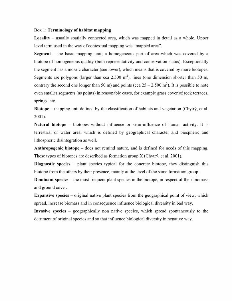
Box 1: Terminology of habitat mapping
Locality – usually spatially connected area, which was mapped in detail as a whole. Upper
level term used in the way of contextual mapping was “mapped area”.
Segment – the basic mapping unit; a homogeneous part of area which was covered by a
biotope of homogeneous quality (both representativity and conservation status). Exceptionally
the segment has a mosaic character (see lower), which means that is covered by more biotopes.
Segments are polygons (larger than cca 2.500 m2), lines (one dimension shorter than 50 m,
contrary the second one longer than 50 m) and points (cca 25 – 2.500 m2). It is possible to note
even smaller segments (as points) in reasonable cases, for example grass cover of rock terraces,
springs, etc.
Biotope – mapping unit defined by the classification of habitats and vegetation (Chytrý, et al.
2001).
Natural biotope – biotopes without influence or semi-influence of human activity. It is
terrestrial or water area, which is defined by geographical character and biospheric and
lithospheric disintegration as well.
Anthropogenic biotope – does not remind nature, and is defined for needs of this mapping.
These types of biotopes are described as formation group X (Chytrý, et al. 2001).
Diagnostic species – plant species typical for the concrete biotope, they distinguish this
biotope from the others by their presence, mainly at the level of the same formation group.
Dominant species – the most frequent plant species in the biotope, in respect of their biomass
and ground cover.
Expansive species – original native plant species from the geographical point of view, which
spread, increase biomass and in consequence influence biological diversity in bad way.
Invasive species – geographically non native species, which spread spontaneously to the
detriment of original species and so that influence biological diversity in negative way.

Box 2: Field practice
Basic (1:10.000) or forestry outlined map (1:10.000) had been used. Detailed mapping covered
entire area while by the contextual one only natural biotopes have been recorded.
Main steps of terrain mapping:
1) Determination of biotope – always the lowest hierarchical level described in the
Catalogue.
2) Demarcation of segment borders in the field and drawing them to the map. In the case
of mosaic segment estimation of percentage of single biotope types present.
3) Estimation of dimensions in case of dot and line segments and also complete all
segment characteristics (representativity), conservation status, age structure).
4) Recording eminent plant species present in the segment and other relevant notes.
5) Taking photos or making phytosociological relevés.
Nomenclature: preferently were used the names recorded in Kubát et al., 2002 resp. in Hejný,
Slavík, 1988, 1990, 1992 and Slavík, 1995, 1997, 2000. Names of syntaxa correspond to
Moravec et al., 1995 or Chytrý et al., 2001.

T a b l e 1. Conservation status (A, B, C are resultant values consequent upon all subcriteria,
for details see text)
OUTLOOKS Excellent Good Adverse
Possibility accessible objectively difficult accessible objectively difficult accessible objectively difficultof restoration and effective possible and effective possible and effective possible
STATUS EXCELLENT A A A A A A A A A
GOOD A A A B B B B B C ADVERSE B B C B C C C C C

T a b l e 2. Database structure of Natura 2000 habitat mapping ID Type: Number Format: F7 Identification number AREA Type: Number Format: F13.6 Area of segment PERIMETE Type: Number Format: F13.6 Perimeter of segment P_K Type: String Format: A1 detailed/contextual MAPA Type: String Format: A6 Code of map 1:10.000 POR_C Type: Number Format: F4 Order number STEJ Type: String Format: A2 Mosaic BIOTOP1 Type: String Format: A5 Code of biotop (up to six
biotopes in mosaic segment)
BIOTOP2 Type: String Format: A5 BIOTOP3 Type: String Format: A5 BIOTOP4 Type: String Format: A5 BIOTOP5 Type: String Format: A5 BIOTOP6 Type: String Format: A5 STEJ_PR1 Type: Number Format: F2 Proportion of biotop (up to
six biotopes in mosaic segment)
STEJ_PR2 Type: Number Format: F2 STEJ_PR3 Type: Number Format: F2 STEJ_PR4 Type: Number Format: F2 STEJ_PR5 Type: Number Format: F2 STEJ_PR6 Type: Number Format: F2 ZAKRES Type: String Format: A1 Point/line/polygon VEL_B Type: Number Format: F7.1 Size in sq-metres VEL_L Type: Number Format: F7.1 Breadth in metres VEK_S_L Type: String Format: A1 Tree layer age structure REPRE Type: String Format: A1 Representativeness ZACH Type: String Format: A1 Conservation status DATUM Type: Number Format: DATE11 Date of field mapping LOKAL Type: String Format: A25 Code of locality LOCALITYAUTOR Type: String Format: A25 AUTHOR POZN Type: String Format: A200 Notice DILO Type: String Format: A8 Code of contract

T a b l e 3. Results of habitat mapping (number of segments and area) and the national habitat interpretation by biotopes (Chytrý et al.,
2001)
HABITAT DESCRIPTION COUNT AREA_HA BIOTOP
1340 *Inland salt meadows 175 128.63 T72330 Open grassland with Corynephorus and Agrostis of
continental dunes 1126 772.14 T5.1 T5.2 T5.3
3130 Oligotrophic to mesotrophic standing waters of plains to subalpine levels of the Continental and Alpine Region and mountain areas of other regions, with vegetation belonging to Littorelletea uniflorae and/or to Isoeto-Nanojuncetea
1345 803.97 M2.1 M2.2 M2.3 M3 V6
3140 Hard oligo-mesotrophic waters with benthic vegetation of Chara formations
173 40.55 V5
3150 Natural eutrophic lakes with Magnopotamion or Hydrocharition-type vegetation
8679 6772.00 V1A V1B V1C V1D V1E V1F
3160 Natural dystrophic lakes and ponds 225 36.47 V33220 Alpine rivers and the herbaceous vegetation along their
banks 96 34.81 M4.3
3230 Alpine rivers and their ligneous vegetation with Myricaria germanica
8 3.10 M4.2
3240 Alpine rivers and their ligneous vegetation with Salix eleagnos
169 65.79 K2.2
3260 Water courses of plain to montane levels with the Ranunculion fluitantis and Callitricho-Batrachion vegetation
1224 1580.60 V4A
3270 Muddy river banks with Chenopodion rubri p.p. and Bidention p.p. vegetation
482 109.41 M6
4030 European dry heaths 5041 1997.76 T8.1B T8.2B T8.34060 Alpine and boreal heaths 461 461.49 A2.1 A2.24070 Bushes with Pinus mugo 278 1353.47 A74080 Subarctic Salix spp. scrub 37 35.72 A8.1 A8.240A0 *Subcontinental peri-Pannonic scrub 499 87.49 K4A K4B5130 Juniperus communis formations on heaths or calcareous
grasslands 578 410.40 T3.4A T3.4B T8.1A T8.2A
6110 *Rupicolous calcareous or basophilic grasslands (Alysso- 361 50.39 T6.2A T6.2B

HABITAT DESCRIPTION COUNT AREA_HA BIOTOPSedion albi)
6150 Siliceous alpine and boreal grassland 489 1128.00 A1.1 A1.2 A36190 Rupicolous pannonic grasslands (Stipo-Festucetalia
pallenstis) 1568 426.99 T3.1 T3.2
6210 Semi-natural dry grassland and scrubland facies on calcareous substrates (Festuco-Brometalia) (*important orchid sites)
20231 16676.98 T3.3C T3.3D T3.4C T3.4D T3.5A T3.5B
6230 *Species-rich Nardus grassland, on siliceous substrates in mountain areas (and submountain areas, in continental Europe)
15926 9247.84 T2.1 T2.2 T2.3A T2.3B
6240 *Sub-Pannonic steppic grasslands 635 378.43 T3.3A6250 *Pannonic loess steppic grasslands 124 95.96 T3.3B6260 *Pannonic sand steppes 57 33.85 T5.46410 Molinia meadows on calcareous, peaty or clayey-silt-laden
soils (Molinion caeruleae) 8986 8295.65 T1.9
6430 Hydrophilous tall herb fringe communities of plains and of the montane to alpine levels
1253 913.40 A4.1 A4.2 A4.3
6430 Hydrophilous tall herb fringe communities of plains and of the montane to alpine levels
31859 16436.99 M5 M7 T1.6 T1.8
6440 Alluvial meadows of river valleys of the Cnidion dubii alliance 482 1038.90 T1.76510 Extensive hay meadows of the plain to submontane levels
(Arrhenatherion, Brachypodio-Centaureion nemoralis) 126587 203802.88 T1.1
6520 Mountain hay meadows 11137 18115.54 T1.27110 *Active raised bogs 1285 826.68 R3.1 R3.37120 Degraded raised bogs (still capable of natural regeneration) 338 589.60 R3.47140 Transition mires and quaking bogs 10841 5116.41 M1.6 R2.2 R2.37150 Depressions on peat substrates 65 12.31 R2.47210 *Calcareous fens with Cladium mariscus and species of the
Caricion davallianae 6 3.97 M1.8
7220 *Petrifying springs with tufa formation 706 43.38 R1.1 R1.37230 Alkaline fens 136 48.10 R2.18110 Siliceous scree of the montane to snow levels
(Androsacetalia alpinae and Galeopsietalia ladani) 417 210.99 A6A
8220 Chasmophytic vegetation of siliceous rocky slopes 36 7.93 A5 A6B8150 Northern upland siliceous screes 361 114.51 S2B

HABITAT DESCRIPTION COUNT AREA_HA BIOTOP8160 *Calcareous scree of hill and montane levels 105 22.37 S2A8210 Chasmophytic vegetation of calcareous rocky slopes 1275 189.62 S1.18220 Chasmophytic vegetation of siliceous rocky slopes 23846 5728.55 S1.28230 Pioneer vegetation on siliceous rock surfaces (Sedo-
Scleranthion, Sedo albi-Veronicion dillenii) 1409 179.79 T6.1A T6.1B
8310 Caves not open to the public 133 3.22 S3B9110 Luzulo-Fagetum beech forests 79544 166336.74 L5.49130 Asperulo-Fagetum beech forests 50509 119696.13 L5.19140 Medio-European subalpine beech woods (with Acer and
Rumex arifolius) 2051 3232.75 L5.2
9150 Medio-European limestone beech forests (Cephalanthero-Fagion)
641 930.06 L5.3
9170 Galio-Carpinetum oak hornbeam forests 82717 145371.60 L3.1 L3.2 L3.3B L3.3C L3.3D9180 *Tilio-Acerion forests of slopes, screes and ravines 22945 25075.51 L49190 Old acidophilous oak woods with Quercus robur on sandy
plains 7118 11569.32 L7.2
91D0 *Bog woodland 7346 17961.27 L10.1 L10.2 L10.3 L10.4 L9.2A R3.291E0 *Mixed ash-alder alluvial forests of temperate and Boreal
Europe (Alno-Padion, Alnion incanae, Salicion albae) 27612 32633.67 L2.1 L2.2A L2.4
91F0 Riparian mixed forests of Quercus robur, Ulmus laevis and Ulmus minor, Fraxinus excelsior or Fraxinus angustifolia, along the great rivers of the Atlantic and Middle-European provinces (Ulmenion minoris)
9483 23796.73 L2.3A L2.3B
91G0 *Pannonic oak-hornbeam forests 2523 6801.92 L3.3A L3.491H0 *Pannonian white-oak forests 928 1217.25 L6.191I0 *Euro-Siberian steppe oak woods 4067 8758.19 L6.2 L6.3 L6.4 L6.5A91T0 Central European lichen pine forests 765 1129.70 L8.1A91U0 Sarmatic steppe pine forests (Cytiso-Pinetalia) 196 247.85 L8.29410 Acidophilous spruce forests (Vaccinio-Piceetea) 22265 69179.80 L9.1 L9.2B L9.3

Fig. 1. Distribution of both natural and seminatural biotopes counted in the Czech Republic (601 960 segments cover 9383.7 km2).