Embed Size (px)
Citation preview


2/8/2012
1
Erie County Agricultural & F l d P i PlFarmland Protection Plan
Methodology for Determining
Agricultural Soils and Natural Resource RatingsResource Ratings
This document demonstrates how the rating system methodology applies to a small area within Erie County Duearea within Erie County. Due to confidentiality of the cropland data, the area is not identified.

2/8/2012
2
The cropland shapefilesprovided by NRCS very closely follow the outlines of fields and pastures that are visible frompastures that are visible from aerial photographs.
Parcels that include less than one acre of cropland/ pasture were deleted from the Agricultural Parcels list and
This parcel contains cropland andis included in the list of Agricultural Parcels
Agricultural Parcels list and shapefile
These parcels were excludedfrom the list .
2/8/2012
3
GIS software calculated the number of acres of each agricultural soils type within the cropland in each parcel
Prime Soils
Prime Soils if Drained
Soils of Statewide Importance
Agricultural Parcels
Cropland
the cropland in each parcel
59 479
20
643
8
15 33
10
79 1010
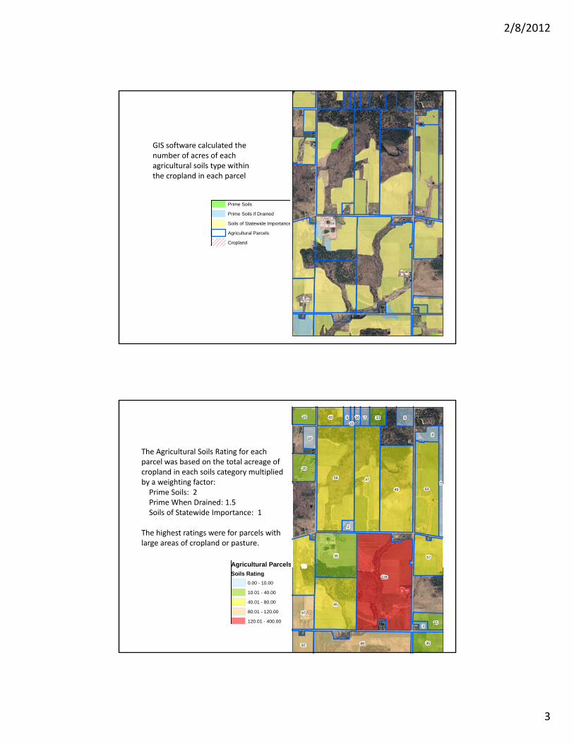
The Agricultural Soils Rating for each parcel was based on the total acreage of cropland in each soils category multiplied by a weighting factor:
Agricultural Parcels
49 64
35
75
57
9
2
by a weighting factor: Prime Soils: 2Prime When Drained: 1.5Soils of Statewide Importance: 1
The highest ratings were for parcels with large areas of cropland or pasture.
Soils Rating0.00 - 10.00
10.01 - 40.00
40.01 - 80.00
80.01 - 120.00
120.01 - 400.00
128
45
88
97
3592
153

2/8/2012
4
The Natural Resources Rating was based on the number of acres within each parcel of the following natural resource features:Within 75 feet of a mapped streamWithin 75 feet of a mapped streamFederal or State Wetland, including 100' buffer from NYS wetlandsWithin 500 feet of Lake Erie shoreline
State or Federal Wetland + 100' Buffer, within Agricultural Parcels
DEC WetlandsDEC Wetlands
Federal Wetlands
75' Stream Buffer within Agricultural Parcels
Streams
Agricultural Parcels
The sum of the acreage within each natural feature (wetlands, stream corridor, Lake Erie buffer) constitutes the Natural Resources Rating. No weighting 0
010
6
0
5
26 00
00
00 00
Need to update to includeFederal wetland info
Natural Resources Rating. No weighting factors were used.
Parcels with higher Natural Resources ratings have more land within a stream corridor or wetland. In areas outside of the one shown, highly ranked parcels are located near Lake Erie.
21
7
2
11
2
Agricultural ParcelsNatural Resources Rating
0.00 - 4.00
4.01 - 8.00
8.01 - 20.00
20.01 - 40.00
40.01 - 600.00
21
9
6
7
6
0
12
0