Embed Size (px)
Citation preview

IAIA18 Conference Proceedings | Environmental Justice in Societies in Transition 38th Annual Conference of the International Association for Impact Assessment
16-19 May 2018 | Durban Intl. Convention Center | Durban | South Africa | www.iaia.org
Ecosystem services and impacts of industrial activities in local catchment areas of the Niger Delta, Nigeria: case study of the Opolo-Gbaran area
Meshach Owho Ojile PhD.
Department of Geography & Environmental Management Niger Delta University, Wilberforce Island PMB 071, Yenagoa, Bayelsa State, Nigeria.
Email: [email protected]
Abstract The issue of ecosystem services represents a hot topic especially in connection with the values and functions, provided to human society. Land use change patterns and increased human and industrial development activities affect the flow of ecosystem services—the benefits that people get from ecosystems. These benefits include the Millennium Assessment’s provisioning services. At the local catchment area in developing countries like Nigeria, the quantification of ecosystem services i is conte andand largely unaccounted for. For example, changes in land use patterns with increased human settlements and industrial activities replacing the natural environment are observable in the Opolo-Gbaran area of Bayelsa State, Nigeria. Increased flooding, fishing,, livelihood and biodiversity impacts have been reportedimpacts have been reported. claimed effects is challenging as The determination of the contribution of industrial and development activities to claimed effects various immeasurable variables (such as climate change) and lack of existing data prevents robust analysis robust analysis. Employing the participatory rural appraisal approaches for socioeconomic data gathering, and utilizing the tools of participant/non-participant observations, key informant interviews and transect walks, this paper reports on the attempt to assess the impacts of oil/gas exploration and development activities on ecosystem services as perceived by the local population as part of a special environmental assessment study of alleged oil/gas pipeline blockage in the area. Key words: ecosystem services, industrial development activities, Opolo-Gbaran area, catchment area, perceived impacts. 1.0 INTRODUCTION One of the major oil and gas players in the Nigerian petroleum industry in the Niger Delta area received complaints from a group of communities of ‘’an alleged blockade of the water flow path across water bodies (Lakes and swamps) in their area by one of their assets, a pipeline’’. This development they alleged, had resulted in the unusual continuous flooding of their Lake even during the dry season, making fishing in the lake impossible and further affecting their means of livelihood. The persistent flooding, they claimed, also affected the biodiversity in the area leading to visible withering of economic trees, among others. Being an environmentally and socially responsible Company, it decided to consult an independent Environmental Management Firm to carry out a scientific study of the alleged impacted area to ascertain the validity and level of significance or otherwise of the claims and to proffer mitigation measures for impacts, where such exists. Pipelines are internationally recognized as the preferred alternative for transport of hydrocarbons from the point of view of safety, economy, reliability, and relative environmentally friendliness (TRB, 2004). This advantage notwithstanding, pipeline development inevitably results in economic, social and environmental change, both positive and negative. It is therefore, the responsibility of pipeline promoters (asset owners), construction contractors and government to manage such developments in a manner that ensures minimal negative impact and maximum sustainability (Swan, 2009). The key issues associated with the installation of new cross-country pipelines vary between projects but often relate to land-take, biodiversity, heritage, pollution control, disruption of livelihoods, community safety, traffic management, loss of remoteness, communicable diseases and employment and trade opportunities.
2
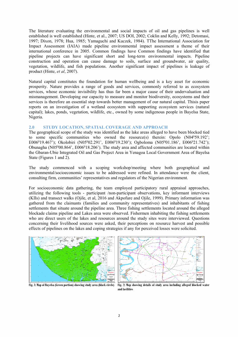
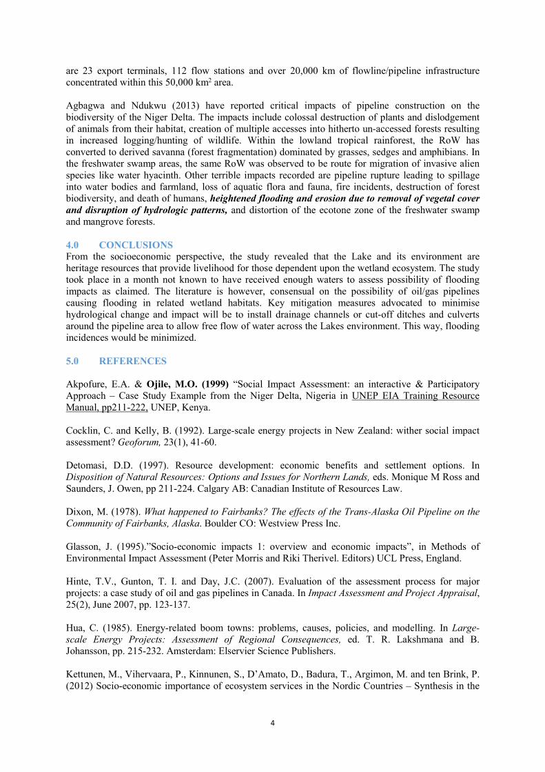
The literature evaluating the environmental and social impacts of oil and gas pipelines is well established is well established (Hinte, et al., 2007; US DOI, 2002; Coklin and Kelly, 1992; Detomasi, 1997; Dixon, 1978; Hua, 1985; Yamaguchi and Kuczek, 1984). TThe International Association for Impact Assessment (IAIA) made pipeline environmental impact assessment a theme of their international conference in 2005. Common findings have Common findings have identified that pipeline projects can have significant short and long-term environmental impacts. Pipeline construction and operation can cause damage to soils, surface and groundwater, air quality, vegetation, wildlife, and fish populations. Another significant impact of pipelines is leakage of product (Hinte, et al, 2007). Natural capital constitutes the foundation for human wellbeing and is a key asset for economic prosperity. Nature provides a range of goods and services, commonly referred to as ecosystem services, whose economic invisibility has thus far been a major cause of their undervaluation and mismanagement. Developing our capacity to measure and monitor biodiversity, ecosystems and their services is therefore an essential step towards better management of our natural capital. Thisis paper reports on an investigation of a wetland ecosystem with supporting ecosystem services (natural capital); lakes, ponds, vegetation, wildlife, etc., owned by some indigenous people in Bayelsa State, Nigeria. 2.0 STUDY LOCATION, SPATIAL COVERAGE AND APPROACH The geographical scope of the study was identified as the lake areas alleged to have been blocked tied to some specific communities who owned the resource(s) therein: Opolo (N04059.192’; E006019.467’); Okolobiri (N05002.291’, E006019.230’); Ogboloma (N05001.186’, E006021.742’); Obunagha (N05000.864’, E006018.206’). The study area and affected communities are located within the Gbaran-Ubie Integrated Oil and Gas Project Area in Yenagoa Local Government Area of Bayelsa State (Figures 1 and 2). The study commenced with a scoping workshop/meeting where both geographical and environmental/socioeconomic issues to be addressed were refined. In attendance were the client, consulting firm, communities’ representatives and regulators of the Nigerian environment. For socioeconomic data gathering, the team employed participatory rural appraisal approaches, utilizing the following tools - participant /non-participant observations, key informant interviews (KIIs) and transect walks (Ojile, et al, 2016 and Akpofure and Ojile, 1999). Primary information was gathered from the claimants (families and community representatives) and inhabitants of fishing settlements that situate around the pipeline area. Three fishing settlements located around the alleged blockade claims pipeline and Lakes area were observed. Fishermen inhabiting the fishing settlements who are direct users of the lakes and resources around the study sites were interviewed. Questions concerning their livelihood sources were asked, their perceptions on resource harvest and possible effects of pipelines on the lakes and coping strategies if any for perceived losses were solicited.
Fig. 1: Map of Bayelsa (Green portion) showing study area (black circle) Fig. 2: Map showing details of study area including alleged blocked water
and facilities

3
3.0 RESULTS AND DISCUSSION 3.1 Fishing Settlements, Fisheries and Agricultural Activities The inhabitants of the three settlements were interviewed on their understanding of the Lake and the state of the environment. Some seventeen (17) male househoold heads and nine (9) female members aged 24-50 years were interviewed across the 3 fishing/farming settlements. Households have an average of 8 members; women have an average of 6 children. Two-thirds of the inhabitants are non-indigenes from other parts of Bayelsa, Delta and Akwa Ibom/Cross River States of Nigeria. They admitted to engaging in fishing in and around the lake but stated full scale fishing starts around July and September when the lake begins to experience overflow. As a consequence, during the drier periods or before the onset of the flood seas, they engage in crop farming and wait for the onset of the flood season. The flood season is considered to be favourable and a better fishing period. Several types of traps, nets and hooks are utilized for fishing. Aquaculture is also common in the area. The Abarigene Lake and fish ponds jointly owned by the communities are used to trap fishes that come inland during the flood seasons and are harvested when the floods subside. Yields from fishing was confirmed to have dropped, due mainly to population pressure, over-fishing, effects of oil spillages and other unsustainable practices. A few of the community members from the permanent communities of Opolo-Epie and others engage in agriculture, including fishing. But, the majority of resource users in the area are temporary residents, are mostly non-indigenes and are engaged in farming and harvesting of fisheries from the water-bodies in the area, including the Abarigene and Asa Lakes. But the engagements and produce are seasonal. The principal crops planted during the farming season include cocoyam, sweet potatoes, plantain, cassava, banana, maize, pepper and vegetables. Qualitative responses from the farmers on yields affirmed some poor and reducing yields over the years due basically to ‘infertility of the soil’, ‘use of crude farming implements’, as well as the lack of capital for large scale investment in agriculture. It was observed during our site visit to the alleged Lake area that the lake has indeed been overgrown with grasses. This naturally makes free flow of water within and across the lake difficult. Both Lakes were covered with grasses and some forest swamp vegetation in some part. As a consequence, interchange and flow of water from one Lake to the other has become difficult because of the blockade by grasses. Settlers confirmed that at this time, ‘’the water level is usually low and as such it is difficult to fish and possibly catch fish in the Lake’’. The alternative pastime is to ‘’engaged more in farming’’, in the months of April to July each year. Observations of the cultivated farmlands revealed farm crops area actually planted around the Lake environment, from which they eke out a livelihood, waiting for the flood season to embark on fishing activity. Settlers thus switch over to fishing at around August/September when the Lake must have become filled up with floodwaters and overflowing. At this point, the overflow covers the entire Lake area and overgrown grasses are overtaken by floodwaters. Individual and communal ponds were claimed to exist in the Asa Lake area but these could not be identified as the whole place was covered with grasses and swamp forest. 3.2 Oil/Gas Pipeline Impacts on Flooding, Livelihood and Biodiversity The completion of every successful oil and gas exploration and production activity is to hook up the producing well to a gathering facility through a flowline. The gathering facility may be a flow station or Floating Production Storage and Offloading (FPSO) system (strictly offshore). These products are transported from the gathering facility to a refinery or outright selling point (terminals) through pipelines. In the Niger Delta, the flowlines and pipelines range from diameter of six inches (6") to thirty six inches (36") with Right of Way (RoW) of 15 m to 30 m in width. Their construction involves acquisition and clearing the RoW of all vegetation and wildlife, and excavation by the open-cut method (thrust boring at major road and river crossings). The open-cut method requires deployment of excavators and other earth-moving equipment: the depth of excavation ranging from 3 m to 15 m. Backfilling after pipe laying is mostly haphazard resulting in blockage of natural drainages and eventual flooding (Agbagwa, 2008, Agbawa and Akpokodje, 2010). At present, there
4
are 23 export terminals, 112 flow stations and over 20,000 km of flowline/pipeline infrastructure concentrated within this 50,000 km2 area. Agbagwa and Ndukwu (2013) have reported critical impacts of pipeline construction on the biodiversity of the Niger Delta. The impacts include colossal destruction of plants and dislodgement of animals from their habitat, creation of multiple accesses into hitherto un-accessed forests resulting in increased logging/hunting of wildlife. Within the lowland tropical rainforest, the RoW has converted to derived savanna (forest fragmentation) dominated by grasses, sedges and amphibians. In the freshwater swamp areas, the same RoW was observed to be route for migration of invasive alien species like water hyacinth. Other terrible impacts recorded are pipeline rupture leading to spillage into water bodies and farmland, loss of aquatic flora and fauna, fire incidents, destruction of forest biodiversity, and death of humans, heightened flooding and erosion due to removal of vegetal cover and disruption of hydrologic patterns, and distortion of the ecotone zone of the freshwater swamp and mangrove forests. 4.0 CONCLUSIONS From the socioeconomic perspective, the study revealed that the Lake and its environment are heritage resources that provide livelihood for those dependent upon the wetland ecosystem. The study took place in a month not known to have received enough waters to assess possibility of flooding impacts as claimed. The literature is however, consensual on the possibility of oil/gas pipelines causing flooding in related wetland habitats. Key mitigation measures advocated to minimise hydrological change and impact will be to install drainage channels or cut-off ditches and culverts around the pipeline area to allow free flow of water across the Lakes environment. This way, flooding incidences would be minimized. 5.0 REFERENCES Akpofure, E.A. & Ojile, M.O. (1999) “Social Impact Assessment: an interactive & Participatory Approach – Case Study Example from the Niger Delta, Nigeria in UNEP EIA Training Resource Manual, pp211-222, UNEP, Kenya. Cocklin, C. and Kelly, B. (1992). Large-scale energy projects in New Zealand: wither social impact assessment? Geoforum, 23(1), 41-60. Detomasi, D.D. (1997). Resource development: economic benefits and settlement options. In Disposition of Natural Resources: Options and Issues for Northern Lands, eds. Monique M Ross and Saunders, J. Owen, pp 211-224. Calgary AB: Canadian Institute of Resources Law. Dixon, M. (1978). What happened to Fairbanks? The effects of the Trans-Alaska Oil Pipeline on the Community of Fairbanks, Alaska. Boulder CO: Westview Press Inc. Glasson, J. (1995).”Socio-economic impacts 1: overview and economic impacts”, in Methods of Environmental Impact Assessment (Peter Morris and Riki Therivel. Editors) UCL Press, England. Hinte, T.V., Gunton, T. I. and Day, J.C. (2007). Evaluation of the assessment process for major projects: a case study of oil and gas pipelines in Canada. In Impact Assessment and Project Appraisal, 25(2), June 2007, pp. 123-137. Hua, C. (1985). Energy-related boom towns: problems, causes, policies, and modelling. In Large-scale Energy Projects: Assessment of Regional Consequences, ed. T. R. Lakshmana and B. Johansson, pp. 215-232. Amsterdam: Elservier Science Publishers. Kettunen, M., Vihervaara, P., Kinnunen, S., D’Amato, D., Badura, T., Argimon, M. and ten Brink, P. (2012) Socio-economic importance of ecosystem services in the Nordic Countries – Synthesis in the
5
context of The Economics of Ecosystems and Biodiversity (TEEB). Nordic Council of Ministers, Copenhagen. Ogon, E.K. (2006) Natural resource abundance in Nigeria: from dependence to development. Resources Policy, 33, 168-174. Ogwu, F. A. (2011). Challenges of Oil and Gas Pipeline Network and the role of Physical Planners in Nigeria. FORUM Ejournal 10 (June 2011): 41-51, Newcastle University. Ojile, M.O., Bodude, D., & Okhade, R. (2016). Community-based GIS Approach to Natural Resource Mapping and Socioeconomic Considerations in Impact Assessment: Case Study of Bayelsa Greenfield Airport Development in Niger Delta, Nigeria. Modern Environmental Science and Engineering (MESE). Vol. 2, No. 6, pp.427-433. Academic Star Publishing Company, ISSN 2333-2581, New York, USA. Ojile, M.O. (2006). Draft Report of the Baseline Socio-economic and Social Impact Assessment (SIA) Aspects for the Environmental Impact Assessment (EIA) of Gbarain Manifold/Location Project, submitted to Scientific Ideas Ltd. on behalf of the SPDC, Port Harcourt. March 2006, 31pp. Sadar, M. H. (1996). Environmental Impact Assessment, 2nd edn. Ottawa ON: Carleton University Press. SPDC (2016). General Background-Special Study: Gbaran Area/Opolo Lake Studies, Shell Petroleum Development Company of Nigeria. Swan, J. (2009). Assessing the environmental impacts of pipelines. Pipelines International, 2009. Transportation Research Board (2004). Transmission pipelines and land use: a risk-informed approach / Committee for Pipelines and Public Safety: Scoping Study on the Feasibility of Developing Risk-Informed Land Use Guidance near Existing and Future Transmission Pipelines, Transportation Research Board, Special Report 281, National Academy of Sciences. US DOI, United States Department of the Interior (2002). Final Environmental Impact Statement, Renewal of the Federal Grant for the Trans-Alaska Pipeline System Right-of-Way: Volumes 1-7. Yamaguchi, S. and E. Kuczek (1984). The social and economic impact of large-scale energy projects on the local economy. International Labour Review, 123(2), 149-165.