Embed Size (px)
Citation preview
Merthyr Mawr Dune Rejuvenation Works Topographic Survey Report
Kenneth Pye & Simon J. Blott Kenneth Pye Associates Ltd
Report No: 96
Date: March 2014

Merthyr Mawr Dune Rejuvenation Works: Topographic Survey, March 2014
www.naturalresourceswales.gov.uk Page ii
About Natural Resources Wales
Natural Resources Wales is the organisation responsible for the work carried out by the three former organisations, the Countryside Council for Wales, Environment Agency Wales and Forestry Commission Wales. It is also responsible for some functions previously undertaken by Welsh Government.
Our purpose is to ensure that the natural resources of Wales are sustainably maintained, used and enhanced, now and in the future.
We work for the communities of Wales to protect people and their homes as much as possible from environmental incidents like flooding and pollution. We provide opportunities for people to learn, use and benefit from Wales' natural resources.
We work to support Wales' economy by enabling the sustainable use of natural resources to support jobs and enterprise. We help businesses and developers to understand and consider environmental limits when they make important decisions.
We work to maintain and improve the quality of the environment for everyone and we work towards making the environment and our natural resources more resilient to climate change and other pressures.
Published by: Natural Resources Wales Maes y Ffynnon Penrhosgarnedd Bangor LL57 2DW 0300 065 3000 © Natural Resources Wales [2014] All rights reserved. This document may be reproduced with prior permission of Natural Resources Wales Further copies of this report are available from the library Email: [email protected]
Merthyr Mawr Dune Rejuvenation Works: Topographic Survey, March 2014
www.naturalresourceswales.gov.uk Page iii
Evidence at Natural Resources Wales
Natural Resources Wales is an evidence based organisation. We seek to ensure that our strategy, decisions, operations and advice to Welsh Government and others are underpinned by sound and quality-assured evidence. We recognise that it is critically important to have a good understanding of our changing environment.
We will realise this vision by:
Maintaining and developing the technical specialist skills of our staff;
Securing our data and information;
Having a well resourced proactive programme of evidence work;
Continuing to review and add to our evidence to ensure it is fit for the challenges facing us; and
Communicating our evidence in an open and transparent way.
This Evidence Report series serves as a record of work carried out or commissioned by Natural Resources Wales. It also helps us to share and promote use of our evidence by others and develop future collaborations. However, the views and recommendations presented in this report are not necessarily those of NRW and should, therefore, not be attributed to NRW.

Merthyr Mawr Dune Rejuvenation Works: Topographic Survey, March 2014
www.naturalresourceswales.gov.uk Page iv
Report series: Evidence Report
Report number: 96
Publication date: 6 May 2014
Contract number: STE0141
Contractor: Kenneth Pye Associates Ltd
Contract Manager: Dr. Emmer Litt
Title: Merthyr Mawr Dune Rejuvenation Works Topographic Survey Report
Author(s): Prof. Kenneth Pye & Dr. Simon J. Blott
Approved By: Dr. Emmer Litt
Restrictions: None
Distribution List (core)
NRW Library, Bangor
Recommended citation for this volume:
KPAL (2014b) Merthyr Mawr Dune Rejuvenation Works Topographic Survey, March 2014. NRW Evidence Report No. 96. Kenneth Pye Associates Ltd., Solihull.
Merthyr Mawr Dune Rejuvenation Works: Topographic Survey, March 2014
www.naturalresourceswales.gov.uk Page v
Contents About Natural Resources Wales ............................................................................................. ii
Evidence at Natural Resources Wales .................................................................................. iii
Contents ................................................................................................................................. v
1. Job Summary ................................................................................................................. 1
2. Error Checking ................................................................................................................ 2
3. Monitoring Results .......................................................................................................... 3
4. Field Photographs ........................................................................................................ 16
Data Archive Appendix ......................................................................................................... 25
Merthyr Mawr Dune Rejuvenation Works: Topographic Survey, March 2014
www.naturalresourceswales.gov.uk 1
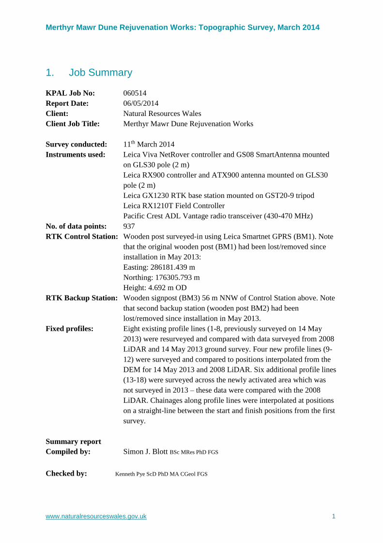
1. Job Summary
KPAL Job No: 060514
Report Date: 06/05/2014
Client: Natural Resources Wales
Client Job Title: Merthyr Mawr Dune Rejuvenation Works
Survey conducted: 11th March 2014
Instruments used: Leica Viva NetRover controller and GS08 SmartAntenna mounted
on GLS30 pole (2 m)
Leica RX900 controller and ATX900 antenna mounted on GLS30
pole (2 m)
Leica GX1230 RTK base station mounted on GST20-9 tripod
Leica RX1210T Field Controller
Pacific Crest ADL Vantage radio transceiver (430-470 MHz)
No. of data points: 937
RTK Control Station: Wooden post surveyed-in using Leica Smartnet GPRS (BM1). Note
that the original wooden post (BM1) had been lost/removed since
installation in May 2013:
Easting: 286181.439 m
Northing: 176305.793 m
Height: 4.692 m OD
RTK Backup Station: Wooden signpost (BM3) 56 m NNW of Control Station above. Note
that second backup station (wooden post BM2) had been
lost/removed since installation in May 2013.
Fixed profiles: Eight existing profile lines (1-8, previously surveyed on 14 May
2013) were resurveyed and compared with data surveyed from 2008
LiDAR and 14 May 2013 ground survey. Four new profile lines (9-
12) were surveyed and compared to positions interpolated from the
DEM for 14 May 2013 and 2008 LiDAR. Six additional profile lines
(13-18) were surveyed across the newly activated area which was
not surveyed in 2013 – these data were compared with the 2008
LiDAR. Chainages along profile lines were interpolated at positions
on a straight-line between the start and finish positions from the first
survey.
Summary report
Compiled by: Simon J. Blott BSc MRes PhD FGS
Checked by: Kenneth Pye ScD PhD MA CGeol FGS
Merthyr Mawr Dune Rejuvenation Works: Topographic Survey, March 2014
www.naturalresourceswales.gov.uk 2
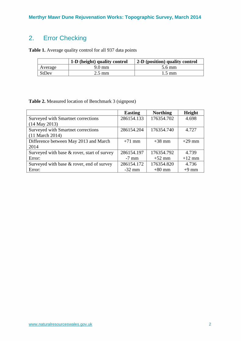
2. Error Checking
Table 1. Average quality control for all 937 data points
1-D (height) quality control 2-D (position) quality control
Average 9.0 mm 5.6 mm
StDev 2.5 mm 1.5 mm
Table 2. Measured location of Benchmark 3 (signpost)
Easting Northing Height
Surveyed with Smartnet corrections
(14 May 2013)
286154.133
176354.702
4.698
Surveyed with Smartnet corrections
(11 March 2014)
286154.204 176354.740 4.727
Difference between May 2013 and March
2014
+71 mm +38 mm +29 mm
Surveyed with base & rover, start of survey 286154.197 176354.792 4.739
Error: -7 mm +52 mm +12 mm
Surveyed with base & rover, end of survey 286154.172 176354.820 4.736
Error: -32 mm +80 mm +9 mm
Merthyr Mawr Dune Rejuvenation Works: Topographic Survey, March 2014
www.naturalresourceswales.gov.uk 3
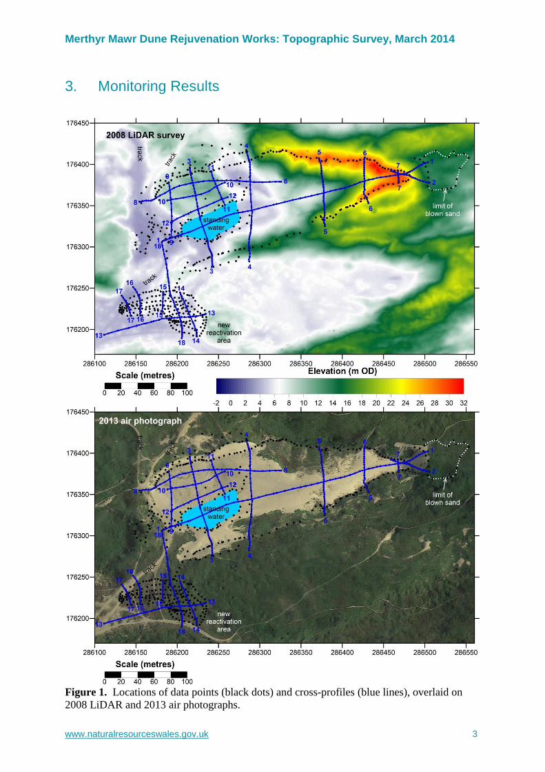
3. Monitoring Results
Figure 1. Locations of data points (black dots) and cross-profiles (blue lines), overlaid on
2008 LiDAR and 2013 air photographs.
Merthyr Mawr Dune Rejuvenation Works: Topographic Survey, March 2014
www.naturalresourceswales.gov.uk 4
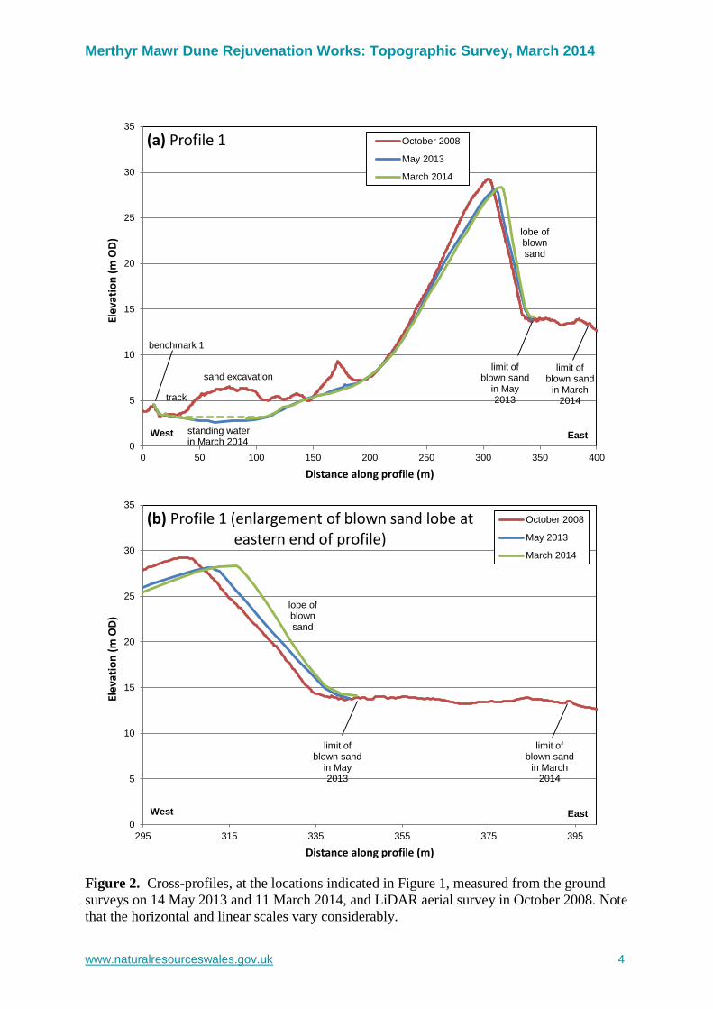
0
5
10
15
20
25
30
35
0 50 100 150 200 250 300 350 400
Ele
vati
on
(m
OD
)
Distance along profile (m)
(a) Profile 1 October 2008
May 2013
March 2014
West East
track
benchmark 1
limit of blown sand
in May 2013
sand excavation
lobe ofblown sand
limit of blown sand
in March 2014
standing water in March 2014
0
5
10
15
20
25
30
35
295 315 335 355 375 395
Ele
vati
on
(m
OD
)
Distance along profile (m)
(b) Profile 1 (enlargement of blown sand lobe ateastern end of profile)
October 2008
May 2013
March 2014
West East
lobe ofblown sand
limit of blown sand
in May 2013
limit of blown sand
in March 2014
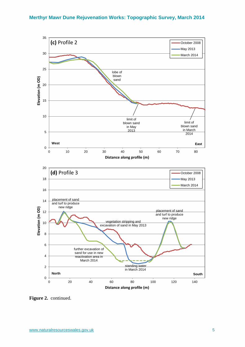
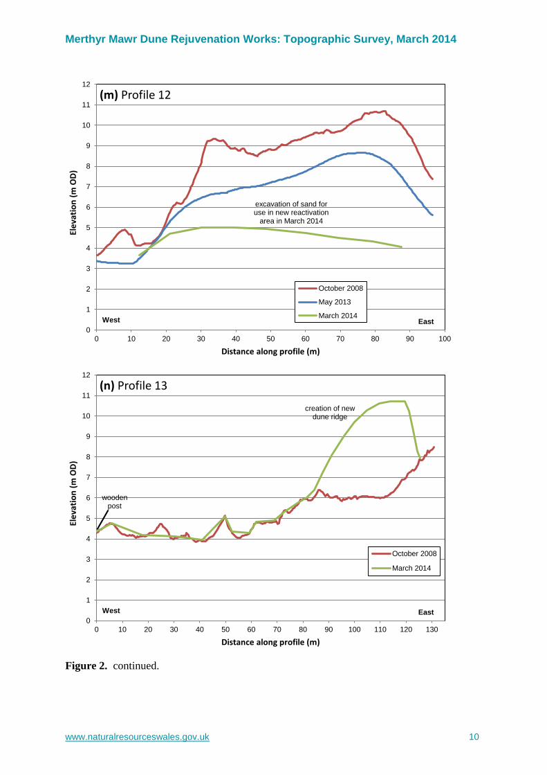
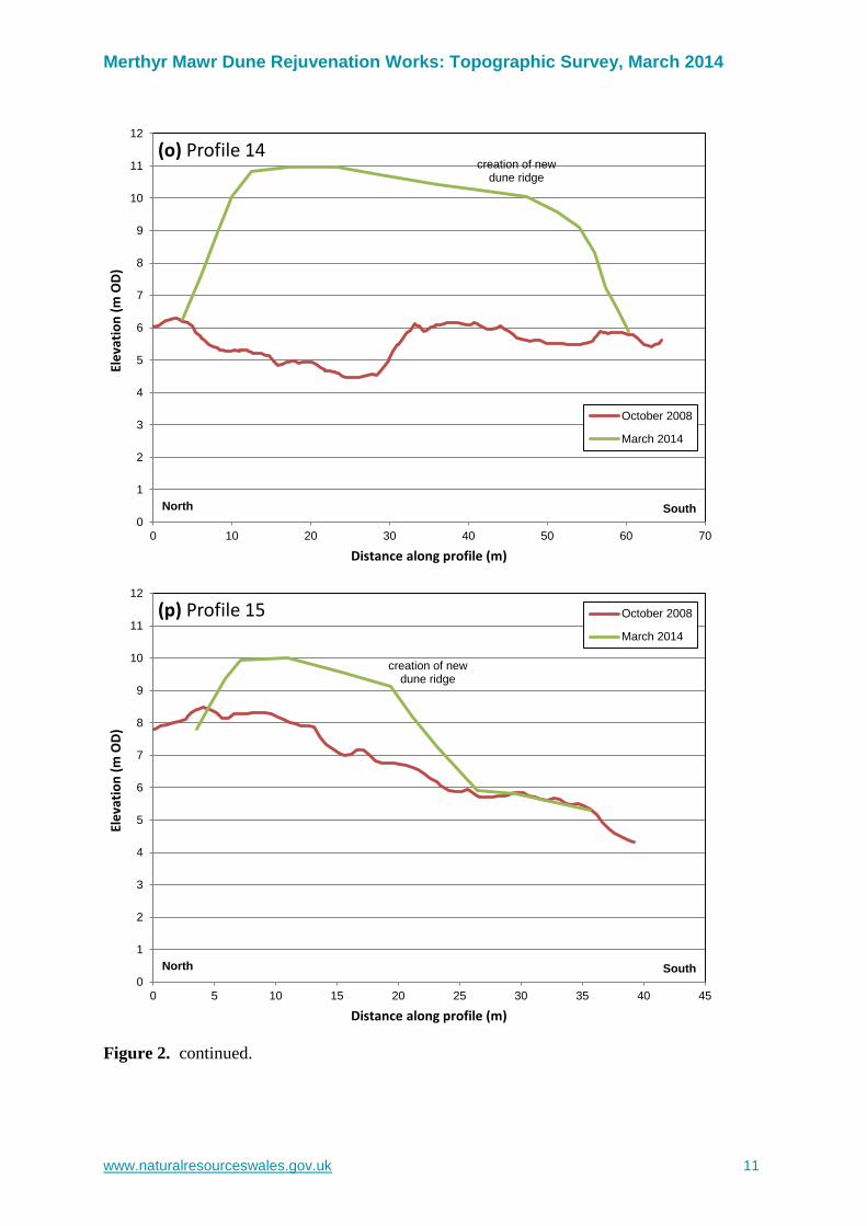
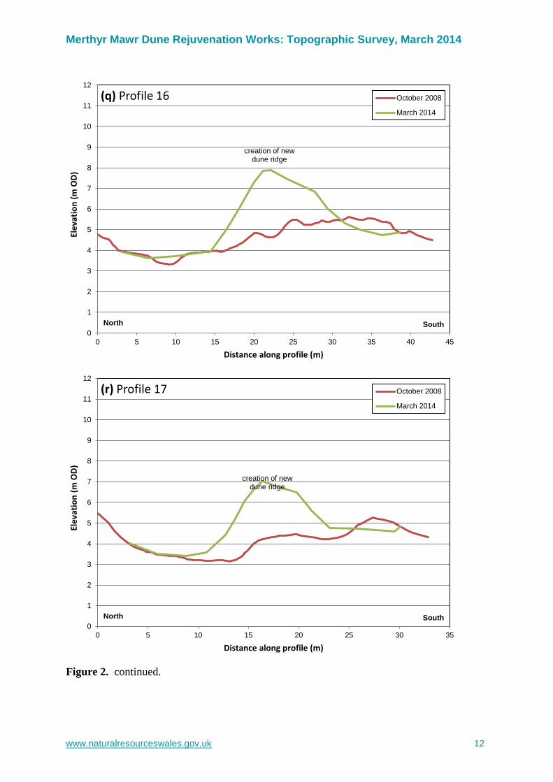
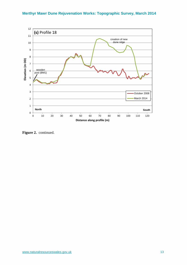
Figure 2. Cross-profiles, at the locations indicated in Figure 1, measured from the ground
surveys on 14 May 2013 and 11 March 2014, and LiDAR aerial survey in October 2008. Note
that the horizontal and linear scales vary considerably.
Merthyr Mawr Dune Rejuvenation Works: Topographic Survey, March 2014
www.naturalresourceswales.gov.uk 5
0
5
10
15
20
25
30
35
0 10 20 30 40 50 60 70 80
Ele
vati
on
(m
OD
)
Distance along profile (m)
(c) Profile 2 October 2008
May 2013
March 2014
West East
lobe ofblown sand
limit of blown sand
in May 2013
limit of blown sand
in March 2014
0
2
4
6
8
10
12
14
16
18
20
0 20 40 60 80 100 120 140
Ele
vati
on
(m
OD
)
Distance along profile (m)
(d) Profile 3 October 2008
May 2013
March 2014
North South
placement of sand and turf to produce
new ridge
placement of sand and turf to produce
new ridge
vegetation stripping and excavation of sand in May 2013
further excavation of sand for use in new reactivation area in
March 2014
standing water in March 2014
Figure 2. continued.
Merthyr Mawr Dune Rejuvenation Works: Topographic Survey, March 2014
www.naturalresourceswales.gov.uk 6
0
2
4
6
8
10
12
14
16
18
20
0 20 40 60 80 100 120 140
Ele
vati
on
(m
OD
)
Distance along profile (m)
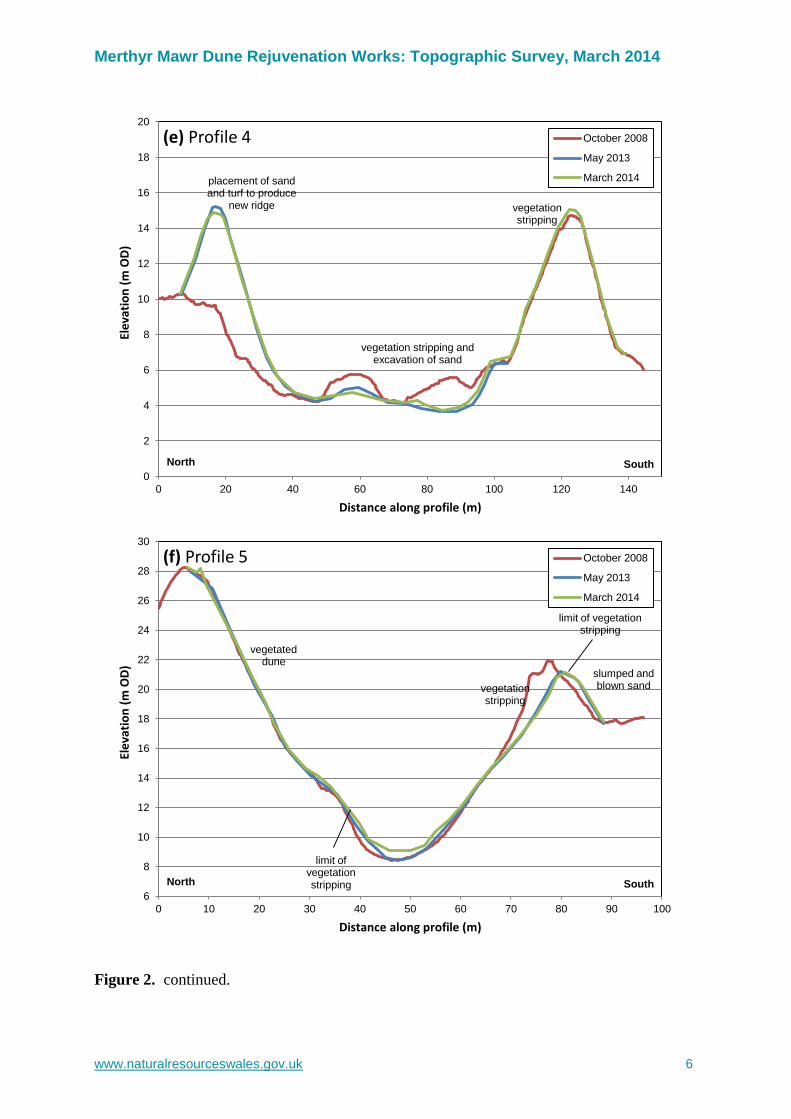
(e) Profile 4 October 2008
May 2013
March 2014
North South
vegetation stripping and excavation of sand
vegetation stripping
placement of sand and turf to produce
new ridge
6
8
10
12
14
16
18
20
22
24
26
28
30
0 10 20 30 40 50 60 70 80 90 100
Ele
vati
on
(m
OD
)
Distance along profile (m)
(f) Profile 5 October 2008
May 2013
March 2014
North South
vegetation stripping
vegetateddune
limit of vegetation stripping
limit of vegetation stripping
slumped and blown sand
Figure 2. continued.
Merthyr Mawr Dune Rejuvenation Works: Topographic Survey, March 2014
www.naturalresourceswales.gov.uk 7
10
12
14
16
18
20
22
24
26
28
30
32
34
0 10 20 30 40 50 60 70 80 90 100
Ele
vati
on
(m
OD
)
Distance along profile (m)
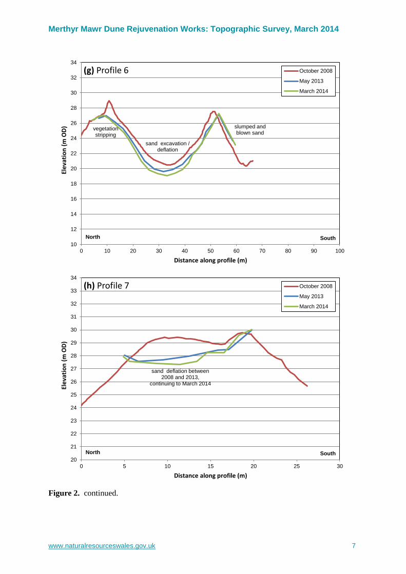
(g) Profile 6 October 2008
May 2013
March 2014
North South
sand excavation /deflation
vegetation stripping
slumped and blown sand
20
21
22
23
24
25
26
27
28
29
30
31
32
33
34
0 5 10 15 20 25 30
Ele
vati
on
(m
OD
)
Distance along profile (m)
(h) Profile 7 October 2008
May 2013
March 2014
North South
sand deflation between 2008 and 2013,
continuing to March 2014
Figure 2. continued.

Merthyr Mawr Dune Rejuvenation Works: Topographic Survey, March 2014
www.naturalresourceswales.gov.uk 8
0
1
2
3
4
5
6
7
8
9
10
11
12
13
14
0 20 40 60 80 100 120 140 160 180 200
Ele
vati
on
(m
OD
)
Distance along profile (m)
(i) Profile 8 October 2008
May 2013
March 2014
West East
vegetation stripping
limit of vegetation stripping
lobe ofblown sand
track
benchmark 3
0
1
2
3
4
5
6
7
8
9
10
11
12
0 10 20 30 40 50 60 70 80
Ele
vati
on
(m
OD
)
Distance along profile (m)
(j) Profile 9 October 2008
May 2013
March 2014
North South
excavation of sand for use in new reactivation
area in March 2014
Figure 2. continued.
Merthyr Mawr Dune Rejuvenation Works: Topographic Survey, March 2014
www.naturalresourceswales.gov.uk 9
0
1
2
3
4
5
6
7
8
9
10
11
12
0 20 40 60 80 100 120
Ele
vati
on
(m
OD
)
Distance along profile (m)
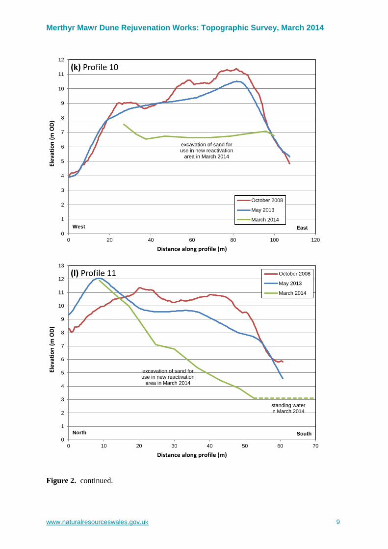
(k) Profile 10
October 2008
May 2013
March 2014
West East
excavation of sand for use in new reactivation
area in March 2014
0
1
2
3
4
5
6
7
8
9
10
11
12
13
0 10 20 30 40 50 60 70
Ele
vati
on
(m
OD
)
Distance along profile (m)
(l) Profile 11 October 2008
May 2013
March 2014
North South
excavation of sand for use in new reactivation
area in March 2014
standing water in March 2014
Figure 2. continued.
Merthyr Mawr Dune Rejuvenation Works: Topographic Survey, March 2014
www.naturalresourceswales.gov.uk 10
0
1
2
3
4
5
6
7
8
9
10
11
12
0 10 20 30 40 50 60 70 80 90 100
Ele
vati
on
(m
OD
)
Distance along profile (m)
(m) Profile 12
October 2008
May 2013
March 2014West East
excavation of sand for use in new reactivation
area in March 2014
0
1
2
3
4
5
6
7
8
9
10
11
12
0 10 20 30 40 50 60 70 80 90 100 110 120 130
Ele
vati
on
(m
OD
)
Distance along profile (m)
(n) Profile 13
October 2008
March 2014
West East
creation of new dune ridge
woodenpost
Figure 2. continued.
Merthyr Mawr Dune Rejuvenation Works: Topographic Survey, March 2014
www.naturalresourceswales.gov.uk 11
0
1
2
3
4
5
6
7
8
9
10
11
12
0 10 20 30 40 50 60 70
Ele
vati
on
(m
OD
)
Distance along profile (m)
(o) Profile 14
October 2008
March 2014
North South
creation of new dune ridge
0
1
2
3
4
5
6
7
8
9
10
11
12
0 5 10 15 20 25 30 35 40 45
Ele
vati
on
(m
OD
)
Distance along profile (m)
(p) Profile 15 October 2008
March 2014
North South
creation of new dune ridge
Figure 2. continued.
Merthyr Mawr Dune Rejuvenation Works: Topographic Survey, March 2014
www.naturalresourceswales.gov.uk 12
0
1
2
3
4
5
6
7
8
9
10
11
12
0 5 10 15 20 25 30 35 40 45
Ele
vati
on
(m
OD
)
Distance along profile (m)
(q) Profile 16 October 2008
March 2014
North South
creation of new dune ridge
0
1
2
3
4
5
6
7
8
9
10
11
12
0 5 10 15 20 25 30 35
Ele
vati
on
(m
OD
)
Distance along profile (m)
(r) Profile 17 October 2008
March 2014
North South
creation of new dune ridge
Figure 2. continued.
Merthyr Mawr Dune Rejuvenation Works: Topographic Survey, March 2014
www.naturalresourceswales.gov.uk 13
0
1
2
3
4
5
6
7
8
9
10
11
12
0 10 20 30 40 50 60 70 80 90 100 110 120
Ele
vati
on
(m
OD
)
Distance along profile (m)
(s) Profile 18
October 2008
March 2014
North South
creation of new dune ridge
woodenpost (BM1)
Figure 2. continued.

Merthyr Mawr Dune Rejuvenation Works: Topographic Survey, March 2014
www.naturalresourceswales.gov.uk 14
Figure 3. Digital elevation model of the restoration works site surveyed on 11 March 2014,
with the black line indicating the limit of the survey. The areas outside the black line are taken
from the LiDAR survey flown in October 2008.
Merthyr Mawr Dune Rejuvenation Works: Topographic Survey, March 2014
www.naturalresourceswales.gov.uk 15
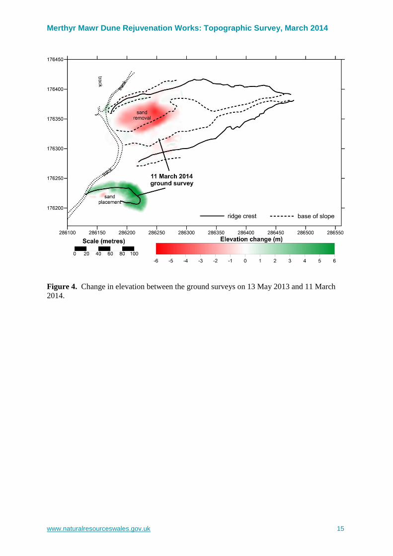
Figure 4. Change in elevation between the ground surveys on 13 May 2013 and 11 March
2014.
Merthyr Mawr Dune Rejuvenation Works: Topographic Survey, March 2014
www.naturalresourceswales.gov.uk 16
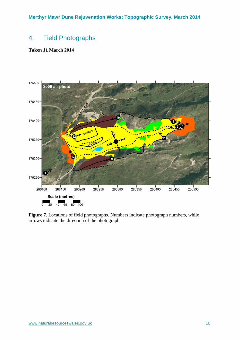
4. Field Photographs
Taken 11 March 2014
Figure 7. Locations of field photographs. Numbers indicate photograph numbers, while
arrows indicate the direction of the photograph
Merthyr Mawr Dune Rejuvenation Works: Topographic Survey, March 2014
www.naturalresourceswales.gov.uk 17
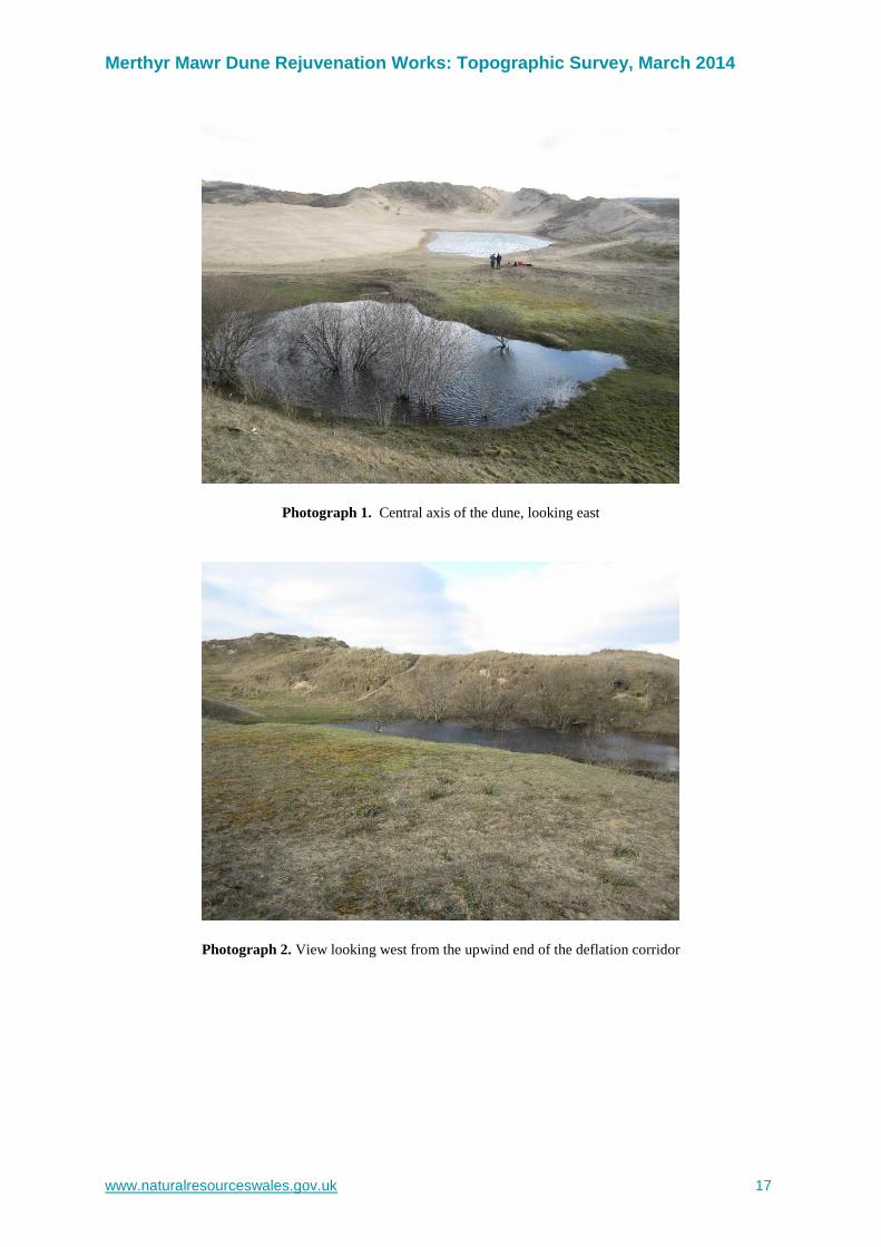
Photograph 1. Central axis of the dune, looking east
Photograph 2. View looking west from the upwind end of the deflation corridor

Merthyr Mawr Dune Rejuvenation Works: Topographic Survey, March 2014
www.naturalresourceswales.gov.uk 18
Photograph 3. The western arm of the dune, looking eastward
Photograph 4. The western arm of the dune, looking westward
Merthyr Mawr Dune Rejuvenation Works: Topographic Survey, March 2014
www.naturalresourceswales.gov.uk 19
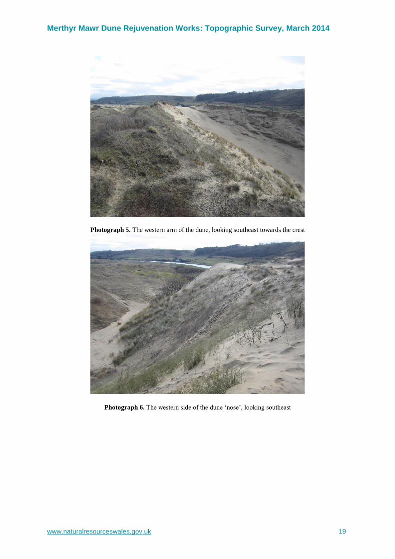
Photograph 5. The western arm of the dune, looking southeast towards the crest
Photograph 6. The western side of the dune ‘nose’, looking southeast
Merthyr Mawr Dune Rejuvenation Works: Topographic Survey, March 2014
www.naturalresourceswales.gov.uk 20
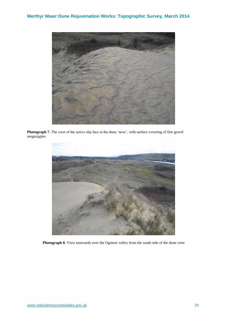
Photograph 7. The crest of the active slip face at the dune ‘nose’, with surface covering of fine gravel
megaripples
Photograph 8. View eastwards over the Ogmore valley from the south side of the dune crest

Merthyr Mawr Dune Rejuvenation Works: Topographic Survey, March 2014
www.naturalresourceswales.gov.uk 21
Photograph 9. View westwards from the dune crest along the axis of the dune
Photograph 10. View west along the western arm of the dune; second phase works visible in the left hand
distance

Merthyr Mawr Dune Rejuvenation Works: Topographic Survey, March 2014
www.naturalresourceswales.gov.uk 22
Photograph 11. The eastern arm of the dune, looking westwards; gravel surface lag evident
Photograph 12. View towards the south from the seaward end of the eastern arm; Phase II works in top right
Merthyr Mawr Dune Rejuvenation Works: Topographic Survey, March 2014
www.naturalresourceswales.gov.uk 23
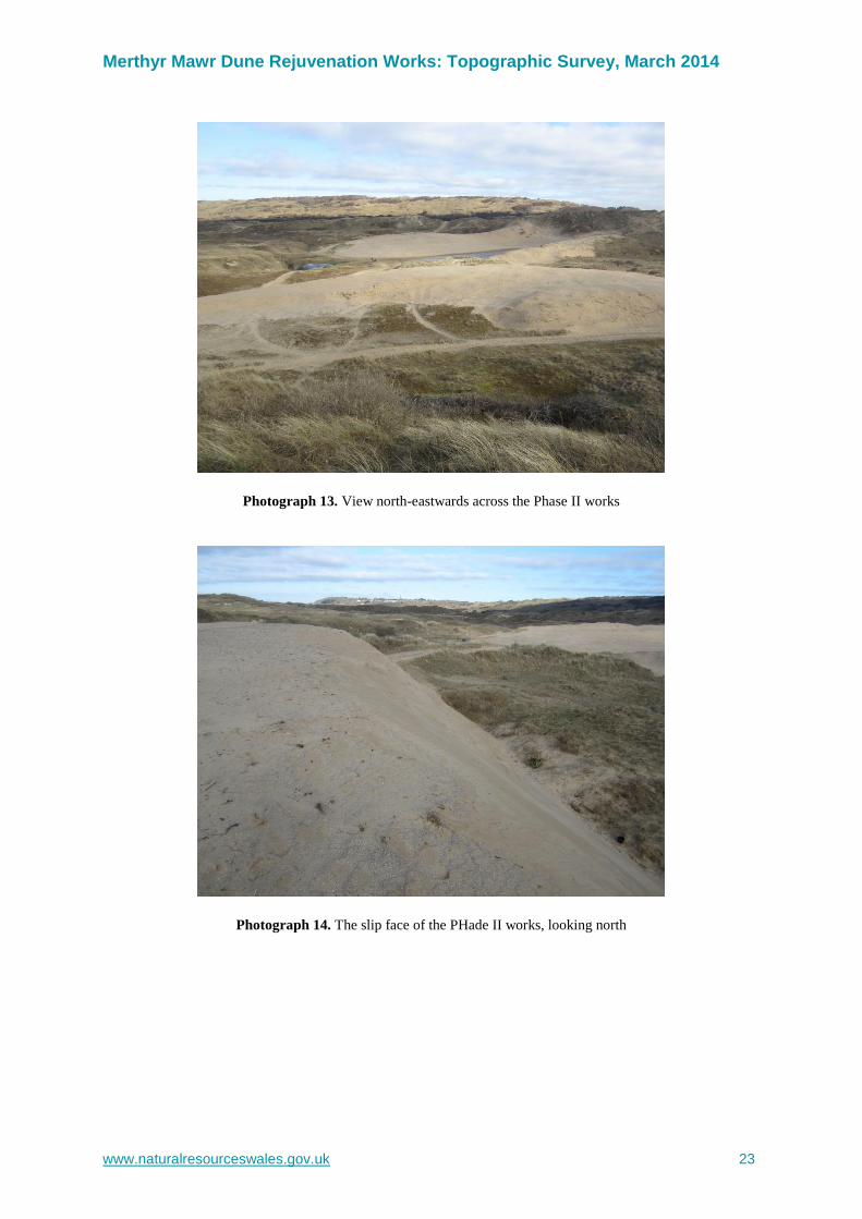
Photograph 13. View north-eastwards across the Phase II works
Photograph 14. The slip face of the PHade II works, looking north
Merthyr Mawr Dune Rejuvenation Works: Topographic Survey, March 2014
www.naturalresourceswales.gov.uk 24
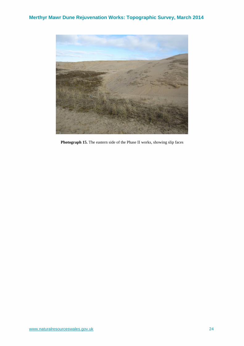
Photograph 15. The eastern side of the Phase II works, showing slip faces
Merthyr Mawr Dune Rejuvenation Works: Topographic Survey, March 2014
www.naturalresourceswales.gov.uk 25
Data Archive Appendix Data outputs associated with this project are archived at ‘Newborough Warren Dune Restoration; project 419, media 1491’ on server–based storage at Natural Resources Wales.
The data archive contains:
[A] The final report in Microsoft Word and Adobe PDF formats.
[B] An Excel file named (Merthyr Mawr Survey 11-03-2014.xls) of data points (x,y,z)
Metadata for this project is publicly accessible through Natural Resources Wales’ Library Catalogue http://libcat.naturalresources.wales/webview/ (English Version) and http://libcat.naturalresources.wales/cnc/ (Welsh Version) by searching ‘Dataset Titles’. The metadata is held as record no [115843]
DO NOT DELETE THE SECTION BREAK BELOW

Published by: Natural Resources Wales Maes y Ffynnon Penrhosgarnedd Bangor LL57 2DW 0300 065 3000 © Natural Resources Wales [2014] All rights reserved. This document may be reproduced with prior permission of Natural Resources Wales Further copies of this report are available from the library Email: [email protected]