Embed Size (px)
Citation preview
Menu of Trigger and SOP for the tropical cyclone forecast
in Bangladesh Noakhali District
Draft
October, 2016
Ahmadul Hassan, Bangladesh
Red Cross/Red Crescent Climate Centre
1
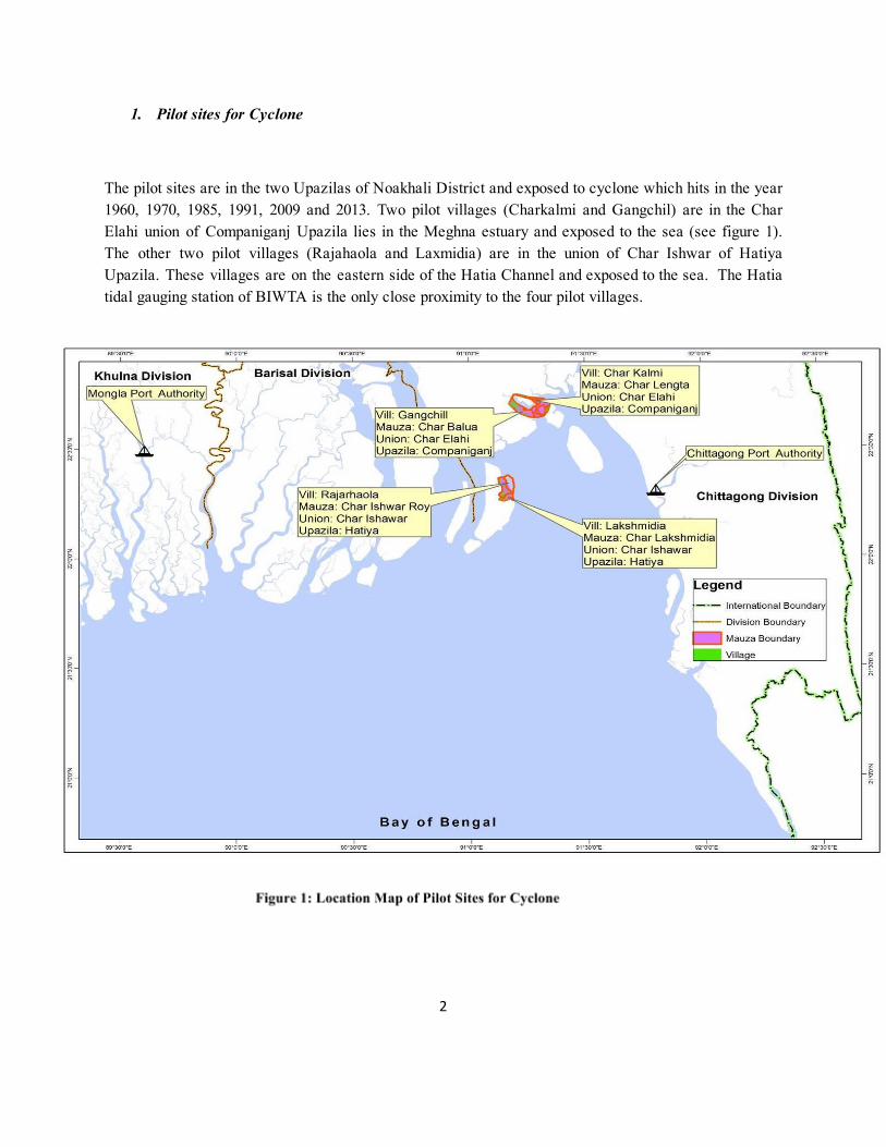
1. Pilot sites for Cyclone
The pilot sites are in the two Upazilas of Noakhali District and exposed to cyclone which hits in the year 1960, 1970, 1985, 1991, 2009 and 2013. Two pilot villages (Charkalmi and Gangchil) are in the Char Elahi union of Companiganj Upazila lies in the Meghna estuary and exposed to the sea (see figure 1). The other two pilot villages (Rajahaola and Laxmidia) are in the union of Char Ishwar of Hatiya Upazila. These villages are on the eastern side of the Hatia Channel and exposed to the sea. The Hatia tidal gauging station of BIWTA is the only close proximity to the four pilot villages.
2

3
2. Define the Danger level for the cyclone.
Damage Level is the magnitude of an extreme event that causes impact (e.g. 88 km/hr of wind speed time duration/intensity required). From which levels (different stage of wind sped/surge height) damage starts to affect the crop production, household’s assets – the livelihoods, infrastructures use at the time of extreme even such as storm surge flood – is called the Danger level (damages not only related with crossing DL). The danger level will depend on the vulnerability and exposure of a region (also timing, when it is happening), and should be updated regularly as the region changes over time. Impact level can be depending on exposed elements to the said hazard. For example, when temperature exceeds limit cause impact on human health and similarly when water reach to the road height the infrastructure will be impacted. DL can be different for agriculture than that of household impact. The danger levels for an area can be defined based on land topography, hydrology, climatology and community perception about the hazard and its impacts. Following template can be used to assess the danger level. It also important to note the availability of forecast while defining the DL.
In Bangladesh, the tropical cyclone has three elements – wind, flood and rain cause impacts to the exposed community. The damages produced by wind are extensive cover areas and occasionally greater than the heavy rainfall and storm surge. The impact of the passage of cyclone eye over the place is highly destructive and quite different from that of an area not hit directly. While storm surge impact is more destructive then the winds when the land fall time coincide with the high tide. No historical evidence that the cyclone induced heavy rainfall cause flooding in the tidal area of the Noakhali District because excellent natural drainage system.
The danger levels for the vulnerable area of the tropical cyclone when any one of the elements ( winds and storm surge) of the events reach the defined limits from which start damaging the infrastructures, assets and finally impacts the livelihoods. Following are the limits:
a. Wind speed in the range of 88117 km/hr (Bangladesh Metrological Department (BMD) signal no 5, 6 & 7 – for details see annex A) extensive damage to thatched huts, uprooting of large tree and the damage the Kutcha houses (which is 95% HH in the pilot area). Depending on the location of the landfall the velocity and impacts vary. The landfall forecast of a cyclone formed in the Bay of Bengal may have different level of impacts on the pilot sites such as low/no impact when the distance of the land fall from the pilot area over 200 km and may have very high impact when the land fall expected to be within the 50 km. It may consider when wind speed will exceed the 88 km/hr and landfall expected to be within +/100 km of the pilot sites based on the forecast.
b. Storm surge induced water level exceeds the yard level of an average households cause loss of life and damage the households assets and finally impact livelihood of the vulnerable houses in the area. There is no operational storm surge floodplain inundation model available with BMD to forecast the depth of inundation in the pilot area. Hence, a rule based approach may be consider to approximate the level of treats/flooding based on following criteria.
4

TLlf, Tide level in meter at forecasted time of landfall TWHlf, Wave height (forecasted by BMD using IITD and MRI model limited to the coast line) Danger level (storm surge) = TLlf + WHlf >= Embankment height (5m for Hatiya and 6m for companiganj)
The Danger level for cyclone for all four pilot sites in the Noakhali District were calculated based on above conditions and detail land elevation survey data on yard level of houses in Table 1. The danger levels were validated by the respective communities through consultation.
Table 1: Danger Levels for Cyclonic Hazard for pilot areas in the Noakhali District
Criteria Danger Level
Hatiya Companiganj Laxmidia Rajar Haola Ghangchil Charkalmi
Wind Landfall (based on forecast track)
+/‐ 100 km +/‐ 100 km +/‐ 100 km +/‐ 100 km
wind speed ( based on warning signal of BMD)
Winds 88‐117 km/hr (Signal
5,6,7)
Winds 88‐117 km/hr (Signal
5,6,7)
Winds 88‐117 km/hr (Signal
5,6,7)
Winds 88‐117 km/hr (Signal
5,6,7) Surge Storm surge (m MSL) exceed
the exisng embankment height
embankment 4.5–5.0 m
embankment 4.5–5.0 m
embankment 5.5–6.0 m
embankment 5.5–6.0 m
The BIWTA tide table shows 17 stations predicted high and low water table with time for the year 2016. The station Char Changa (in Hatiya) of the BWITA is the closed station to plot sites. Three tidal gauges were installed to analyze the tidal situation at the time landfall. Based on the monitoring data from the gauges, it is found that 45 mints phase difference of the tidal peak between pilot site in Hatiya and Companiganj. Tide comes early in the Companiganj than Hatiya and 1.5 meter higher amplitude.
3. Observations and Forecast of Cyclone
The cyclones cross over the Bangladesh coast and Hatiya were analyzed based on historical data of RSMC (Regional Specialized Meteorological Centre), New Delhi from 1891 to 2015. For last 124 years shows 89 cyclones (intensity: CS – Cyclonic Storm and SCS – Severe Cyclone Storm) made landfall over Bangladesh coast (fig2), out of 89 cyclones 29 (32.6%) made landfall over or near Hatiya (fig3). Out of 21 land falling cyclones over or near Hatiya 45 % are Cyclonic Storm (CS) and 55% are Severe Cyclonic Storm (SCS). CS and SCS type cyclone cross over or within 100 km the island Hatiya 2.3 nos in the period of 10 years.
5
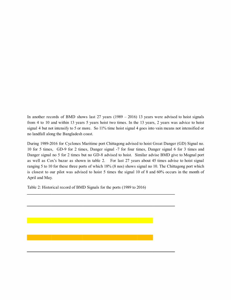
In another records of BMD shows last 27 years (1989 – 2016) 13 years were advised to hoist signals from 4 to 10 and within 13 years 5 years hoist two times. In the 13 years, 2 years was advice to hoist signal 4 but not intensify to 5 or more. So 11% time hoist signal 4 goes into vain means not intensified or no landfall along the Bangladesh coast.
During 19892016 for Cyclones Maritime port Chittagong advised to hoist Great Danger (GD) Signal no. 10 for 5 times, GD9 for 2 times, Danger signal 7 for four times, Danger signal 6 for 3 times and Danger signal no 5 for 2 times but no GD8 advised to hoist. Similar advise BMD give to Mognal port as well as Cox’s bazar as shown in table 2. For last 27 years about 45 times advise to hoist signal ranging 5 to 10 for these three ports of which 18% (8 nos) shows signal no 10. The Chittagong port which is closest to our pilot was advised to hoist 5 times the signal 10 of 8 and 60% occurs in the month of April and May.
Table 2: Historical record of BMD Signals for the ports (1989 to 2016)
Incidence of Cyclone Signals hosted in the Ports BMD Signal Chi찁agong Cox,s_Bazar Mongla Total Percent
5 2 0 5 7 16% 6 3 3 1 7 16% 7 4 5 2 11 24% 8 0 0 5 5 11% 9 2 5 0 7 16% 10 5 2 1 8 18%
Total > 16 15 14 45 100% 36% 33% 31% 100%
Date source BMD record book 1989 to 2016
6
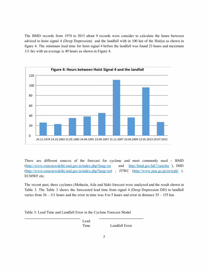
The BMD records from 1974 to 2015 about 9 records were consider to calculate the hours between advised to hoist signal 4 (Deep Depression) and the landfall with in 100 km of the Hatiya as shown in figure 4. The minimum lead time for hoist signal 4 before the landfall was found 23 hours and maximum 111 hrs with an average is 49 hours as shown in Figure 4.
There are different sources of the forecast for cyclone and most commonly used – BMD ( http://www.rsmcnewdelhi.imd.gov.in/index.php?lang=en and http://bmd.gov.bd/?/satelite ), IMD ( http://www.rsmcnewdelhi.imd.gov.in/index.php?lang=en ) , JTWC ( http://www.jma.go.jp/en/typh/ ). ECMWF etc.
The recent past, three cyclones (Mohasin, Aila and Sidr) forecast were analyzed and the result shown in Table 3. The Table 3 shows the forecasted lead time from signal 4 (Deep Depression DD) to landfall varies from 36 – 111 hours and the error in time was 4 to 5 hours and error in distance 55 – 155 km.
Table 3: Lead Time and Landfall Error in the Cyclone Forecast Model
Lead Time Landfall Error
7
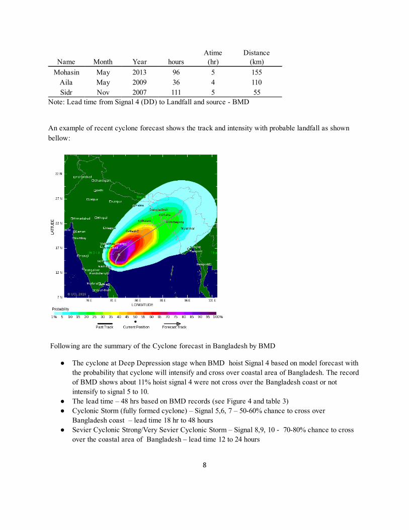
Name Month Year hours Atime (hr)
Distance (km)
Mohasin May 2013 96 5 155 Aila May 2009 36 4 110 Sidr Nov 2007 111 5 55
Note: Lead time from Signal 4 (DD) to Landfall and source BMD
An example of recent cyclone forecast shows the track and intensity with probable landfall as shown bellow:
Following are the summary of the Cyclone forecast in Bangladesh by BMD
The cyclone at Deep Depression stage when BMD hoist Signal 4 based on model forecast with the probability that cyclone will intensify and cross over coastal area of Bangladesh. The record of BMD shows about 11% hoist signal 4 were not cross over the Bangladesh coast or not intensify to signal 5 to 10.
The lead time – 48 hrs based on BMD records (see Figure 4 and table 3) Cyclonic Storm (fully formed cyclone) – Signal 5,6, 7 – 5060% chance to cross over
Bangladesh coast – lead time 18 hr to 48 hours Sevier Cyclonic Strong/Very Sevier Cyclonic Storm – Signal 8,9, 10 7080% chance to cross
over the coastal area of Bangladesh – lead time 12 to 24 hours
8
Cyclone track – error in landfall forecast in time +/ 45 hr and distance +/ 55 155 km
4. Trigger: Menu of options to activate SOP
TRIGGER: A forecast issuance is a trigger for action when the danger level is forecast at a high enough probability. The probability is agreed upon beforehand amongst all stakeholders. For example, a forecast of a 50% chance of exceeding a danger level is a trigger to disburse unconditional cash grant.
As the more lead time means more time for preparedness activity but less accuracy means more chance to “act in vain”. Hence need a menu of Triggers to provide options for the decision makers to choose. The menu of triggers have three criteria are: (a) lead time how much time will have to act on it (implement the SOP); (b) accuracy what is the probability crossing/exceeding the Danger Level (winds or surge height) and (c) frequency – how many times trigger can be happened in a given year.
Table 4: Menu of Triggers, Pilot Sites in Noakhali District
Forecast Trigger Options
Criteria 1 2 2
Warning Signals, BMD 4
(potenal to increase the intensity – DD to CS equivalent signal
7 or more)
7
(CS)
10
(SCS/VSVS)
Landfall / Track Haya Coast line: +/‐ 110 km
Haya
+/‐ 55 km
Haya
+/‐ 55 km
Storm surge TL‐lf + WH‐lf > Embankment height
TL‐lf + WH‐lf > Embankment height
TL‐lf + WH‐lf > Embankment height
Accuracy (%), as reported by BMD
11% chance not cross over Bangladesh
coast
Lead Time (hours) 48‐72 18‐36 12‐18
Frequency 7 in 10 years 1.2 in 10 years 1.2 in 10 years
The above Table 4 represents menu of triggers for the pilot sites in the Noakhali district. Three menus were developed with the variables like the warning signals, lead time, landfall time & storm surge
9
height, accuracy and frequency of the forecast to exceed the Danger level (winds or surges). Where, the danger level is different for each pilot sites as shown in Table 1.
Menu 1 has been proposed for trigger after consultation with experts from BMD, Ministry of Disaster management, BDRCS and RC/RC as trigger based early action as per SOP need at leas 48 hours.
Hence, GRC delegate will trigger the SOP when following condition (“Menu 1”) are reached:
BMD advice to hoist Signal no 4 (deep depression stage of the tropical cyclone in the Bay of Bengal)
The forecast shows (BMD/IMD/ECMWF/other) (a) track – cross over the Hatiya (center line +/100 km); (b) lead time before the landfall Min. 48 hr – enough time to act on SOP; (c) clear indication the Deep Depression (DD) will be intensified to Cyclonic Storm (CS) or more; and/or (d) at the time of the landfall the tidal level + predicted wave height over the height of the embankment (see table 1).
Based on historic record of BMD 11% of Signal 4 not intensified to higher level or not have landfall.
Note: If BMD advice to hoist signal no 4 but not have 48 hr or more lead time GRC not going to trigger the SOP as there not enough time to respond.
5. Define Act in Vain
When the trigger reached and SOP is activated (i.e. money already distributed to the beneficiaries) based on cyclone forecast but cyclone disappear or not hit the area within 200 km or wind speed less than 61 km/hr and storm surge height less than max tide level.
Condition –
No land fall; or Wind speed does not exceed 61km/hr; or Storm surge height not exceed maximum tide level.
Act in Vain
If above condition, Falls Alarm, prevail then following activity can be performed (not yet discussed in the community and BDRCS)
Each beneficiaries HH provide five person days labour for community risk reduction activity Build/repair community resource to reduce risk – e.g. Repair embankment – to protect the
community HH from tidal surge; build access road to the shelter or build or raise schools playground for livestock shelter or other demands to fulfill the common benefit to reduce risk.
10

We want to return in kind/labour day’s equivalent to 2000 taka out of 5000 taka from the beneficiaries.
11
4W (When, What, Who, Where) of Triggering SOP
Preliminary works:
When: During 1 st and 2 nd week of Previous month of the cyclone season, the beneficiaries list must be prepared.
What: Prepare the beneficiaries list with mobile phone number, address, national ID etc.
Who: The Senior Project Officer, GRC/IFRC with support from the Project Officer, BDRCS/GRC/IFRC, ULO BDRCS, Technical Officer, GRC/IFRC and volunteers will prepare the list of beneficiaries with mobile phone number, address, national ID etc.
Where: At the community level in Noakhali District. The CDMC (Community Disaster Management Committee) will provide necessary support to prepare the beneficiary list.
Preparation
When: At the onset of cyclone season (April May and Oct Nov) of any cyclone season not based on seasonal forecast.
What: Transfer the money from German Red Cross (GRC) Dhaka account to Electronic Money Service Providers account Bangladesh Post Office (BPO) at the Head Quarter (HQ) in Dhaka in the 3 rd and 4 th week of previous month of cyclone season.
Who: FBF Project delegate of GRC transfer the money to “Forecast based Financing” account at the BPO and get acknowledgement. Operation rules of the fund are specified in the Memorandum of Agreements (MoA) among BPO and GRC.
Where: Actions is implemented in Dhaka, Bangladesh.
Get Ready
When: Signal no. 4 ( at least 48 hours before the event) the Bangladesh Meteorological Department (BMD) suggests that the wind speed in the FbF Project communities may exceed the Danger Level (DL).
What: Ensure availability of the money and resource at the Booths of the Post Office and PO agent in the community level. Monitor/confirm the availability of enough preparedness materials in the shops of the community. Charge mobile phone and monitor the forecast message at the BMD website, cyclone may be coming.
12
Who: FBFProject Delegate of GRC will inform written/electronically the designated person of BPO to ensure availability of fund at the outlets (preselected agent’s Booths) in the four pilot communities).The ULO and Technical Officer of Noakhali unit office will organize meeting and distribute roles and responsibility of Unit officers and RCY and members of DMC to check the booth’s availability, inform the beneficiaries in the community to watch the mobile message. And inform the Union Disaster Management Committee (UDMC) takes preparation for evacuation and makes available clean space for shelter.
Where: This action is implemented at HQ Dhaka and Unit Office Noakhali covering four pilot sites in Hatiya and Companigonj Upazila of Noakhali District.
Note: The money will not be transferred to the beneficiaries’ mobile number until the Trigger is reached.
Trigger (menu 1): Cyclone is coming and activate SOP / 11% change to act in vain
When: BMD advice to hoist signal 4 and like to increase the intensity and expected landfall within 100 km of Hatiya island. The forecasted wind speed or tidal surge may exceed the DL. And atleast 48 hours lead time will be available to response.
What: a) FbF delegate sign on the trigger to distribute the unconditional cash grant to the
beneficiaries mobile phone account/number. b) BPO/PO agent sends money to the beneficiary’s mobile phone account/number. The
beneficiaries shall collect the money from the Agent’s Booths. For this purpose beneficiaries must come to the community level Agent’s Booths with their mobile phone (received massage from BPO) and National ID card/Birth Certificate/GRC ID and HH ID.
c) BDRCSW/GRC volunteers will check the claim against the beneficiaries list with proper IDs.
d) The Agent’s Booths of BPO will verify the PIN code and National ID Card to confirm. e) Agents of BPO will hand over the cash to the beneficiaries. f) ULO of BDRCS and TO, GRC/IFRC and volunteer will monitor the shops where the
beneficiates will purchase the goods with reasonable price. g) Upazilla Police will also provide the security while collecting money.
Who: Approximately 2,800 household beneficiaries will receive the unconditional cash grant of Taka 5000 equivalent EURO 59.
Where: The action is implemented at community level, Unit levels and Dhaka HQ.
13

14
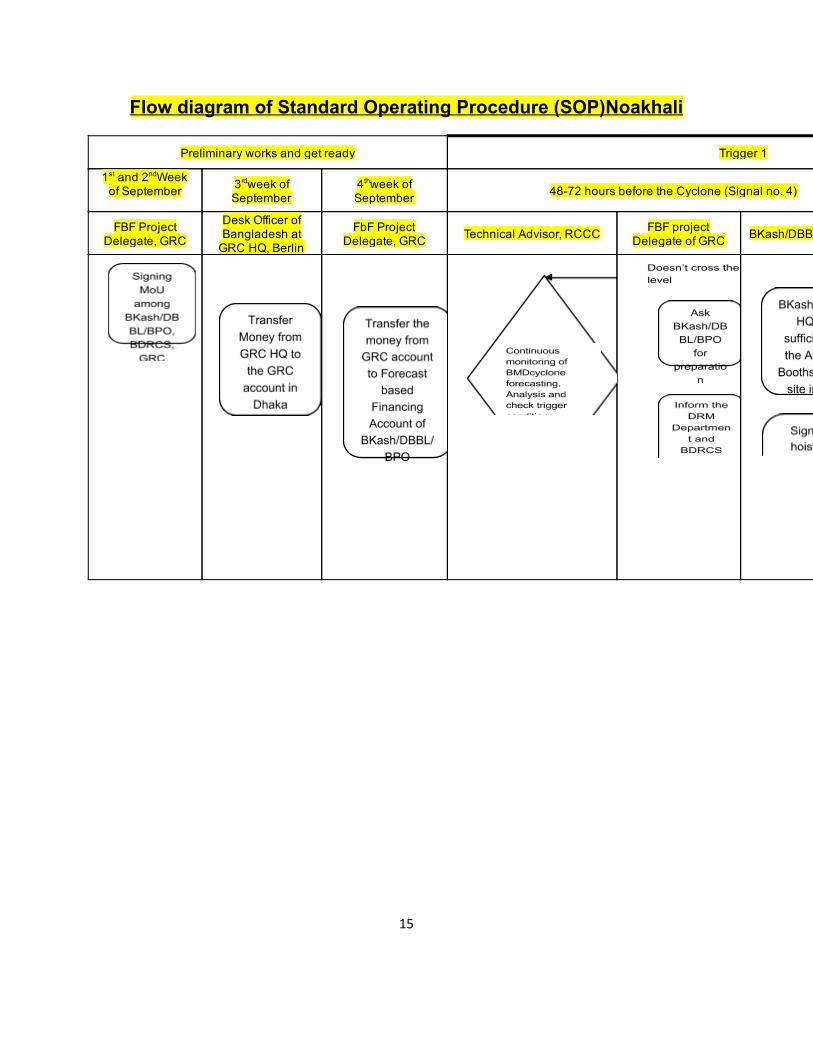
Flow diagram of Standard Operating Procedure (SOP)Noakhali
Preliminary works and get ready Trigger 1
1 st and 2 nd Week of September 3 rd week of
September 4 th week of September 4872 hours before the Cyclone (Signal no. 4)
FBF Project Delegate, GRC
Desk Officer of Bangladesh at GRC HQ, Berlin
FbF Project Delegate, GRC Technical Advisor, RCCC FBF project
Delegate of GRC BKash/DBBL/BPO HQ
15
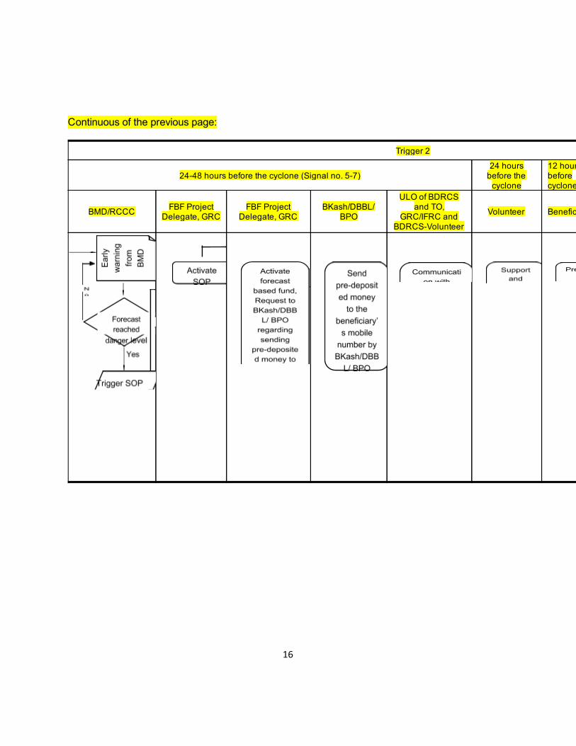
Continuous of the previous page:
Trigger 2
2448 hours before the cyclone (Signal no. 57) 24 hours before the cyclone
12 hoursbefore cyclone
BMD/RCCC FBF Project Delegate, GRC
FBF Project Delegate, GRC
BKash/DBBL/ BPO
ULO of BDRCS and TO,
GRC/IFRC and BDRCSVolunteer
Volunteer Beneficiaries
16
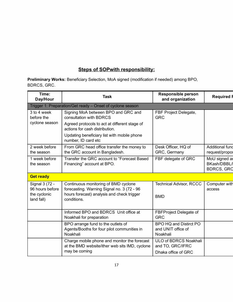
Steps of SOPwith responsibility:
Preliminary Works: Beneficiary Selection, MoA signed (modification if needed) among BPO, BDRCS, GRC.
Time: Day/Hour Task Responsible person
and organization Required Resources
Trigger 1: Preparation/Get ready – Onset of cyclone season 3 to 4 week before the cyclone season
Signing MoA between BPO and GRC and consultation with BDRCS Agreed protocols to act at different stage of actions for cash distribution. Updating beneficiary list with mobile phone number, ID card etc
FBF Project Delegate, GRC
2 week before the season
From GRC head office transfer the money to the GRC account in Bangladesh.
Desk Officer, HQ of GRC, Germany
Additional fundrequest/proposal approved
1 week before the season
Transfer the GRC account to “Forecast Based Financing” account at BPO.
FBF delegate of GRC MoU signed amongBKash/DBBL/BPO,BDRCS, GRC
Get ready Signal 3 (72 96 hours before the cyclonic land fall)
Continuous monitoring of BMD cyclone forecasting. Warning Signal no. 3 (72 96 hours forecast) analysis and check trigger conditions.
Technical Advisor, RCCC BMD
Computer with internetaccess
Informed BPO and BDRCS Unit office at Noakhali for preparation
FBFProject Delegate of GRC
BPO arrange fund to the outlets of Agents/Booths for four pilot communities in Noakhali
BPO HQ and Distirct PO and UNIT office of Noakhali
Charge mobile phone and monitor the forecast at the BMD website/ither web sits IMD, cyclone may be coming
ULO of BDRCS Noakhali and TO, GRC/IFRC Dhaka office of GRC
17
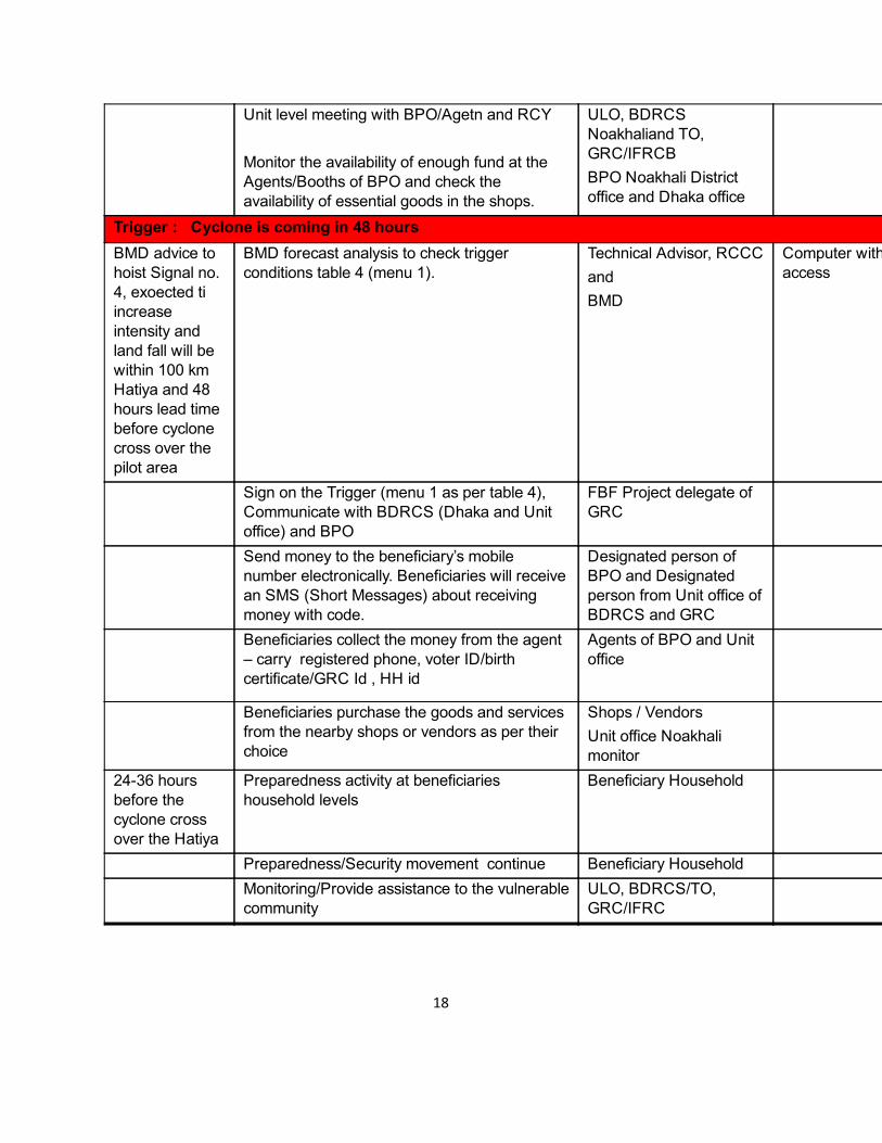
Unit level meeting with BPO/Agetn and RCY Monitor the availability of enough fund at the Agents/Booths of BPO and check the availability of essential goods in the shops.
ULO, BDRCS Noakhaliand TO, GRC/IFRCB BPO Noakhali District office and Dhaka office
Trigger : Cyclone is coming in 48 hours BMD advice to hoist Signal no. 4, exoected ti increase intensity and land fall will be within 100 km Hatiya and 48 hours lead time before cyclone cross over the pilot area
BMD forecast analysis to check trigger conditions table 4 (menu 1).
Technical Advisor, RCCC and BMD
Computer with internetaccess
Sign on the Trigger (menu 1 as per table 4), Communicate with BDRCS (Dhaka and Unit office) and BPO
FBF Project delegate of GRC
Send money to the beneficiary’s mobile number electronically. Beneficiaries will receive an SMS (Short Messages) about receiving money with code.
Designated person of BPO and Designated person from Unit office of BDRCS and GRC
Beneficiaries collect the money from the agent – carry registered phone, voter ID/birth certificate/GRC Id , HH id
Agents of BPO and Unit office
Beneficiaries purchase the goods and services from the nearby shops or vendors as per their choice
Shops / Vendors Unit office Noakhali monitor
2436 hours before the cyclone cross over the Hatiya
Preparedness activity at beneficiaries household levels
Beneficiary Household
Preparedness/Security movement continue Beneficiary Household Monitoring/Provide assistance to the vulnerable
community ULO, BDRCS/TO, GRC/IFRC
18
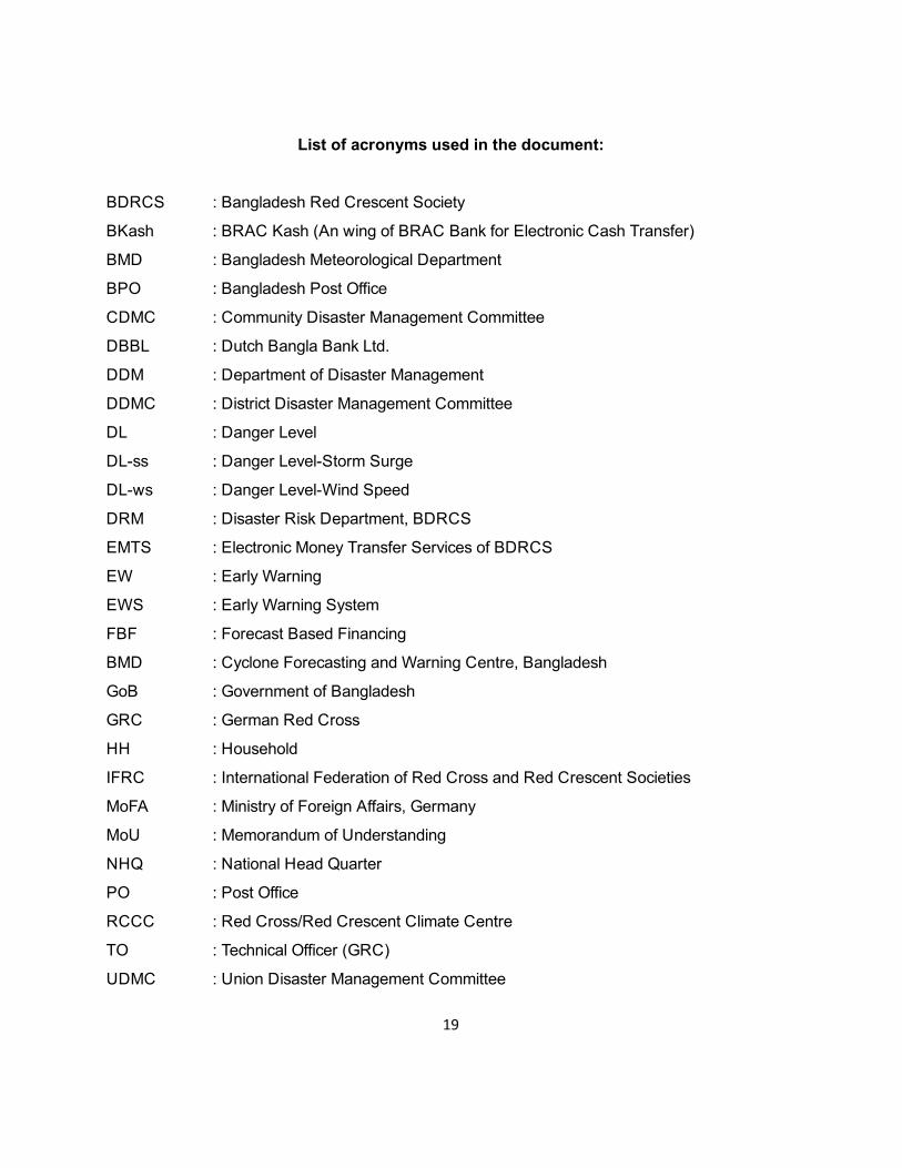
List of acronyms used in the document:
BDRCS : Bangladesh Red Crescent Society
BKash : BRAC Kash (An wing of BRAC Bank for Electronic Cash Transfer)
BMD : Bangladesh Meteorological Department
BPO : Bangladesh Post Office
CDMC : Community Disaster Management Committee
DBBL : Dutch Bangla Bank Ltd.
DDM : Department of Disaster Management
DDMC : District Disaster Management Committee
DL : Danger Level
DLss : Danger LevelStorm Surge
DLws : Danger LevelWind Speed
DRM : Disaster Risk Department, BDRCS
EMTS : Electronic Money Transfer Services of BDRCS
EW : Early Warning
EWS : Early Warning System
FBF : Forecast Based Financing
BMD : Cyclone Forecasting and Warning Centre, Bangladesh
GoB : Government of Bangladesh
GRC : German Red Cross
HH : Household
IFRC : International Federation of Red Cross and Red Crescent Societies
MoFA : Ministry of Foreign Affairs, Germany
MoU : Memorandum of Understanding
NHQ : National Head Quarter
PO : Post Office
RCCC : Red Cross/Red Crescent Climate Centre
TO : Technical Officer (GRC)
UDMC : Union Disaster Management Committee
19

ULO : Unit Level Officer
UNDP : United Nantions Development Program
UzDMC : Upazilla Disaster Management Committee
PWD : Public Works Department (of Bangladesh)
20