Embed Size (px)
Citation preview

MemphisBrooke Haugrud
Memphis is the city and capital of ancient Egypt during the Old Kingdom (c. 2925–c. 2650 BC). It is located south of the Nile River delta, on the west bank of the river, and about 15 miles (25 km) south of modern Cairo. Closely associated with the ancient city's site are the cemeteries, or necropolises, of Memphis.
History
Memphis is considered the legendary city of Menes, the King who united Upper and Lower Egypt. Menes founded the city by creating dikes to protect the area from Nile floods. Memphis was more likely a fortress from which Menes controlled the land and water routes between Upper Egypt and the Delta.
The original name of the city was the White Wall, and the term may have referred originally to the Menes’ palace, whose walls
would have been built of whitewashed brick. The color also had political significance: white was the color of the Lower Egyptian crown.
The name, Memphis, we use today derives from the Pyramid of Pepy I at Saqqara, which is Men-nefer, the name of the pyramid city of the 6th-dynasty. This relatively small and obscure pyramid thus gave its name to the entire region. At that time the influence of the centralized government at Memphis began to diminish, as is indicated by the increased fame of local cities and the number of fine tombs located away from the Memphis area. This process of decentralization ended in the First Intermediate Period, a time of internal breakdown. Manetho's 7th and 8th dynasties are both
called Memphite, but it is believed that both dynasties together comprised a very short period and that the old Memphite house lost its control over the provincial princes soon after the end of the 6th dynasty.
The importance of Memphis was based to a considerable extent on its venerable religious role. Certain of the coronation ceremonies were traditionally enacted in Memphis, as was the Heb-Sed festival, a reenactment of the coronation that restored and restated the supernatural powers of the kingship.
During the New Kingdom period (c. 1539–1075), Memphis probably functioned as the second, or northern, capital of Egypt. At one time it seems to have been the principal residence of the crown prince.
Then in the later Dynasties, Thebes became the capital of Egypt, but we know that Memphis retained much of its religious significance and continued to prosper during this period. Actually, Thebes was never exactly the administrative center of Egypt which Memphis was, its significance being more religious.
By the 18th Dynasty, the Egyptian Kings had apparently moved back into the Palaces of Memphis. But when the Greeks arrived, and moved the Egyptian capital to Alexandria, Memphis suffered, and with the entrance of Christianity and the decline of Egyptian religion, Memphis became a mere shadow of the former great city. But the actual demise of Memphis probably occurred with the invasion of the Muslim conquerors in 641 when they established their new capital not at Memphis, but a short distance
north of the city at Fustat, which is now a part of Cairo called Old Cairo, or Coptic Cairo.
Memphis Today
Most of the monuments were robbed throughout history for their stone. The stone was then used for the building of Cairo. Most of the other remains of the ancient city are covered by the modern village of Badrasheen.
Sites We Will See
The museum that we will visit in Memphis has the colossal limestone statue of Ramesses II (1290-1224 BC). To see the statue, there is a viewing balcony that runs around the statue and provides good views from above.
Outside the museum building, is a sculpture garden contains a scattered assortment of statuary, coffins, and architectural fragments recovered from the area of Memphis. The Egyptian

alabaster sphinx is one of the largest sphinxes found in Egypt, and there are several statues of Ramesses II in granite and limestone as well as a curious sarcophagus carved upside down also lies in the garden. There will be also a series of stalls selling replicas of Egyptian artifacts in the garden.
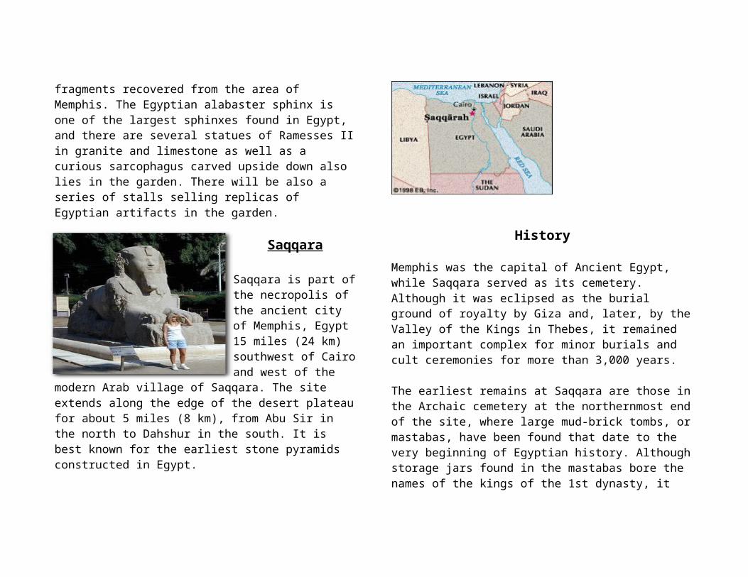
Saqqara
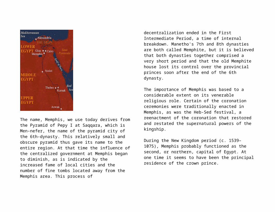
Saqqara is part of the necropolis of the ancient city of Memphis, Egypt 15 miles (24 km) southwest of Cairo and west of the modern Arab village of Saqqara. The site extends along the edge of the desert plateau for about 5
miles (8 km), from Abu Sir in the north to Dahshur in the south. It is best known for the earliest stone pyramids constructed in Egypt.
History Memphis was the capital of Ancient Egypt, while Saqqara served as its cemetery. Although it was eclipsed as the burial ground of royalty by Giza and, later, by the Valley of the Kings in Thebes, it remained an important complex for minor burials and cult ceremonies for more than 3,000 years.
The earliest remains at Saqqara are those in the Archaic cemetery at the northernmost end of the site, where large mud-brick tombs, or mastabas, have been found that date to the very beginning of Egyptian history. Although storage jars found in the mastabas bore the names of the kings of the 1st dynasty, it seems that these tombs were those of high officials of the period, because the Archaic kings were buried at Abydos in Upper Egypt.
One of the most famous tombs is Step Pyramid complex of Djoser, king of the 3rd dynasty (c. 2650–c. 2575 BC), which lies South of the Archaic cemetery. Djoser's architect Imhotep designed a new form of burial structure for the king in the shape of a pyramid in six stages which is how it became known as the Step Pyramid. At the foot, Imhotep constructed a huge complex of halls and courts in which the prototype structures of mud brick, wood, and reed were for the first time translated into fine limestone.
Next, there is Shepsekaf of the 4th dynasty who built Mastabat Fir'awn, a coffin-shaped tomb, and several kings of the 5th dynasty also constructed their pyramids at Saqqarah.
One of the last kings, Unas of the 5th dynasty, was the first to inscribe on the walls of his pyramid chambers the Pyramid Texts, which were designed to protect the dead king and to ensure him life and provisions in the afterlife.
Succeeding kings of the 6th dynasty continued the practice of inscribing Pyramid Texts in the underground chambers. With the exception of Teti, the 6th-dynasty kings built their pyramids to the south of Unas' pyramid, and the most southerly is that of a 13th-dynasty (c. 1756–c. 1630 BC) king.
Around the pyramids of their royals, the Old Kingdom (c. 2575–c. 2130 BC) nobles were buried in mastabas. The wall carvings within their tombs depict scenes of daily life.
During the Middle Kingdom period (1938–c. 1600? BC), relatively few tombs were built in the Saqqarah necropolis, for provincial cemeteries were then popular.
In the New Kingdom (1539–1075 BC), however, Memphis became a principal administrative and military centre, and a number of tombs from that period have been found, including the finely decorated tomb of the general, later king, Horemheb, discovered in 1975. Also, in that era and later the sacred Apis bulls were buried at Saqqarah in large subterranean galleries, the most famous of which is the Sarapeum.
The last imposing tombs to be built in Saqqarah were those of several rulers during the Saite and Persian periods. In the northwestern part of the necropolis, beneath a field of mastabas of the 3rd and 4th dynasties, another complex of underground
passages contains thousands of ibis mummies of the Ptolemaic period.
Sites to See
Step Pyramid:This is a pyramid complex like no other. It is the first stone pyramid to be built in Egypt, and its form imitates wood, papyrus, mud brick, and matting in limestone. The step pyramid started out as a mastaba tomb, but its design was modified six times before the final step pyramid was made. The structure was enlarged by accreting vertical faces, visible on the east side as you walk around the pyramid.
You enter the complex from a small doorway that leads through a long passage. This small passage then turns into a vast open Heb-Sed court. The Heb-Sed was a race that the pharaoh had to run every 30 years, in order to reaffirm his strength, power, and ability to rule.

Niankhkhnum and Khnumhotep’s Mastaba:This is the tomb known as the two brothers. It is known for its fine colors as well as the unusually intimate poses of the two tomb owners. The brothers worked as the pharaoh’s body servants, and they were buried together in this decorated joint tomb. The scenes in the mastaba are fairly standard showing everyday activities such as fishing, cooking, and hunting.
Mereruka’s Mastaba:This tomb was shared by Mereruka, his wife, and his son. It is the largestmastaba tomb in Saqqara and also shows some of the finest scenes of fishing hunting, metalworking, sailing, and force-feeding of animals
Kagemni’s Mastaba:This mastaba is connected to Mereruka’s tomb. It too is also very well decorated.
Teti’s Pyramid:This pyramid measures 257 ft square and originally rose to 172 ft. By looking at the pyramid today, you would not think that it was one because the casing stones were stolen and the structure has been reduced to a pile of rubble. It has two queen pyramids to the east and north, and a mortuary temple to the east.
The Serapeum: This is the site of the burials of the Apis Bull. The Apis Bull was a bull that was regarded as a manifestation of Ptah, a creator god. During the bull’s lifetime, it was worshiped, fed, washed, brushed, and sung to. When it died, it was mummified and buried, with golden grave goods, in a large basalt or granite sarcophagus. Then, the priests boarded a new quest for a new bull, who took up the position of Apis. The dusty and gloomy Serapeum galleries stretch for miles under the bedrock.

Ti’s Mastaba:This mastaba is unique from all the others because
it has a large courtyard that contains a stairway leading to Ti’s Chamber, which still holds his sarcophagus today. The rest of the tomb
is elegantly decorated and painted. It also has much of the original roof preserved throughout the tomb.
Things to Know Before-Hand
At Saqqara the main ticket booth is at the main entrance. Once you are there, you must buy camera tickets from separate booths at each area. No flash photography is allowed inside the tombs.


Cairo, EgyptBy: Kristin Anderson
GeographyLocated on the banks and islands of the Nile River in
Northern Egypt, 12 miles south of where Nile splits into two main branches. Near Giza, Saqqara, and Memphis
Map from http://www.mapsofworld.com/egypt/maps/egypt-political-map.jpg
Two Sections to the City1. New Cairo
-built on the model of Paris-Marked by Wide Boulevards, public gardens, and open spaces-Government Buildings, Modern Architecture
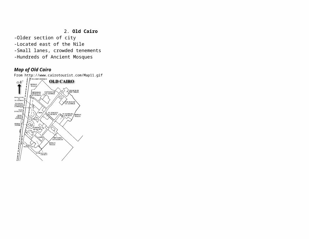
2. Old Cairo-Older section of city-Located east of the Nile-Small lanes, crowded tenements-Hundreds of Ancient Mosques
Map of Old Cairo From http://www.cairotourist.com/Map11.gif

Map of Cairo, Egypt Map from http://www.egyptologyonline.com/cairo_map.gif
History~Islamic Conquest (641-969)
During this period the Arabs decided to abandon Alexandria because there was no body of water near the city. The moved to where present day Cairo now is and founded the city of Al-Fustat. (The name comes from Arabic word for camp or tent). During this time the Mosque of Africa is built, named Amr and a new capital slowly begins to grow as other cities, such as Alexandria and Byzantine, decline in population. This new city now linked eastern and western Egypt together.
~Triumphant City (969-1168)During this era, a Fatimid general named Gawhar captures city and
renames it Al-Qahira, Cairo, which means The Triumphant. For 200 years descendents of Fatimid general Gawhar ruled city. These rulers began the construction of the Al-Azhar, which is the oldest university still in use to date. The use of slaves, which were called Mamelukes, also became popular. These slaves were seen more as civil servants rather than hard labor workers and were able to improve their status in society by converting to Islam. At the end of this era the Egypt was his by a seven year drought which caused widespread plague and a sharp decrease in population.
~Age of Salahideen and the Crusades (1168-1250)Egypt was battleground between Seljuks, who were originally from
central Asia, and Crusaders in 1168. The Seljuks were able to capture Cairo and took control of the city. The leader Shirkoh was named the first leader, but died one year later. Shirkoh’s nephew Saladin took over after his death. Saladin expelled the Fatimids and sent them into exile. During his rule he also built five colleges, hospitals and a mosque (the Citadel), all within 11 years.
~Ruled by the Mamluk (1250-1517)
After the death of Saladin in 1249 there was no strong successor to take control of the city. Shagarit El-Dorr, Saladin’s wife and the last Ayyubid Sultan, becomes Monarch. She ruled alone for 80 days until pressured into marriage by other officers.

She later Murders her husband because he wanted to marry another woman. Shortly after she is then killed by her fellow people after she had “gone to far”
During Mamelouk time, a major geographic change also took place in Cairo. The Nile used to flow further east than it does today. The railroad station is actually located where a canal once stood. In the Twelfth Century, a ship sank near the port and caused the river to change it’s course and begin flowing more to the west of it’s original path. As a result, the Elephant Island (Geziret el-Feel) which resulted from siltation around the sunken ship, and Gezira Island which emerged further west were formed. Later, the region around the Elephant Island silted further to form the area occupied today by the downtown.
~Osmaniye’s Age (1517-1798)In 1517 the Ottomans defeat Mamluks and took over Cairo. During
this time the government separated into three different divisions: Local, military, and political. The government also used the Janissaries and Azabs as soldiers to defend Cairo. These soldiers actually defeated Constantinople in 1453. Overall this was a pretty bad age for the city of Cairo because little was done to improve social and economic status city.
~European Influence (1798-1801)Napoleon conquers the city in 1798 and the French rule until 1801.
During their rule they mis-treated the Al-Azhar mosque but also brought the city out of the “dark age” by establishing many schools and colleges.
~Muhammad Ali comes into rule (1801-1882)Muhammad Ali came into rule in 1801 and rebuilt the infrastructure of
city. The Mosque of Muhammad Ali is built, cotton is introduced and construction of the first railroad also begins.
~Britain Rule (1883-1922)Britain begins to rule in 1883. Egypt was effectively ruled by the
British Consul, Lord Cromer. During this time a sense of Nationalism grew among citizens and Egypt was finally granted independence from Britain in 1922
EconomyPopulation (2005): Over 18 Million
City: 7,438,376 Metro: 11,128,000
36% of People Under Age of 15Growth Rate: 1.6%Average household Size: 4.4¼ of all Egyptians live in CairoDense city with fueled construction
1 of 5 buildings is less than 15 years old

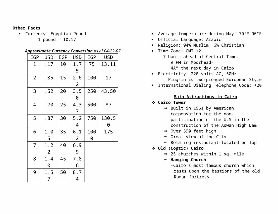
Other Facts Currency: Egyptian Pound
1 pound = $0.17
Approximate Currency Conversion as of 04-22-07EGP USD EGP USD EGP USD
1 .17 10 1.75 75 13.112 .35 15 2.62 100 173 .52 20 3.50 250 43.504 .70 25 4.37 500 875 .87 30 5.24 750 130.506 1.05 35 6.12 1000 1757 1.22 40 6.998 1.40 45 7.869 1.57 50 8.74
Average temperature during May: 70°F-90°F Official Language: Arabic Religion: 94% Muslim; 6% Christian Time Zone: GMT +2
7 hours ahead of Central Time: 9 PM in Moorhead= 4AM the next day in Cairo
Electricity: 220 volts AC, 50Hz Plug-in is two-pronged European Style
International Dialing Telephone Code: +20
Main Attractions in Cairo Cairo Tower
∞ Built in 1961 by American compensation for the non-participation of the U.S in the construction of the Aswan High Dam
∞ Over 590 feet high∞ Great view of the City∞ Rotating restaurant located on Top
Old (Coptic) Cairo∞ 25 churches within 1 sq. mile∞ Hanging Church
-Cairo’s most famous church which rests upon the bastions of the old Roman fortress
-Built in 11th century, rebuilt many times-Marble Pulpit is considered oldest lasting marble
pulpit in the country∞ Ben Ezra Synagogue
-Egypt's oldest Synagogue -Originally the Church of St. Michael
Khan al-Khalili ∞ Usually just called the Khan∞ One of Largest Markets in the World∞ Built in 1382 ∞ Many things to buy including: exotic perfume,
Arabic clothing, gold, silver, copper and spices. Islamic (Medieval) Cairo
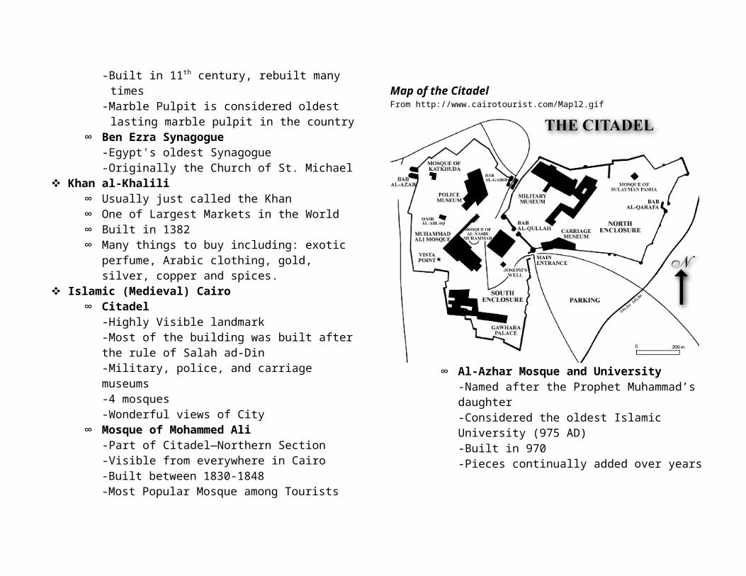
∞ Citadel-Highly Visible landmark-Most of the building was built after the rule of Salah ad-Din -Military, police, and carriage museums-4 mosques-Wonderful views of City
∞ Mosque of Mohammed Ali -Part of Citadel—Northern Section
-Visible from everywhere in Cairo-Built between 1830-1848-Most Popular Mosque among Tourists
Map of the Citadel From http://www.cairotourist.com/Map12.gif
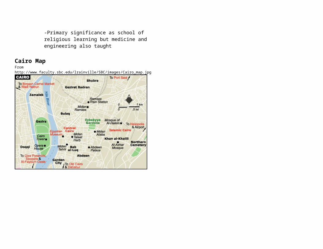
∞ Al-Azhar Mosque and University-Named after the Prophet Muhammad’s daughter-Considered the oldest Islamic University (975 AD)-Built in 970-Pieces continually added over years-Primary significance as school of religious learning but medicine and engineering also taught
Cairo Map From http://www.faculty.sbc.edu/lrainville/SBC/images/Cairo_map.jpg

The PyramidsProgression of Pyramids
The Following were the key pyramids built in the ancient times which contributed to the construction of the first true shaped
pyramid1. Step Pyramid
– Built by Djoser – Made from Matabas, which looked like square mounds,
stacked on top of each other2. Meidum Pyramid
– Built by Sneferu in the beginning of the 4th dynasty– Originally a 7 stepped pyramid—enlarged to 8 steps– Eventually filled in steps and smooth outer facing to
make it look like today’s modern pyramid3. Bent Pyramid
– Very obvious bent appearance– Built by Sneferu in Dashur– 1st attempt at a true pyramid– Lower part rises at 55 degree angle, top part built at 43
degrees1. because of structural problems2. Built on poor foundation without adequate bearing
capacity4. Red or North Pyramid
– First true pyramid– Built by Sneferu– Same slope of 43 degrees (like bent)– Designers much more careful with choice of site and
foundation– Used horizontal placement of core stones
Major Pyramids We Will See While in Egypt1. Step Pyramid2. Great Pyramid3. Pyramid of Khafre4. Pyramid of Mycerinus
Step Pyramid– Location : Saqqara– Dates built: 2800 B.C., during 3rd Dynasty– Built for: King Djoser– Built by: Imhotep, vizier and chief architect of Djoser– Characteristics:
1. Several Layers, or Steps of Stone2. No Pictures or drawings found of what it originally
looked like3. Robbed of most of its limestone centuries ago
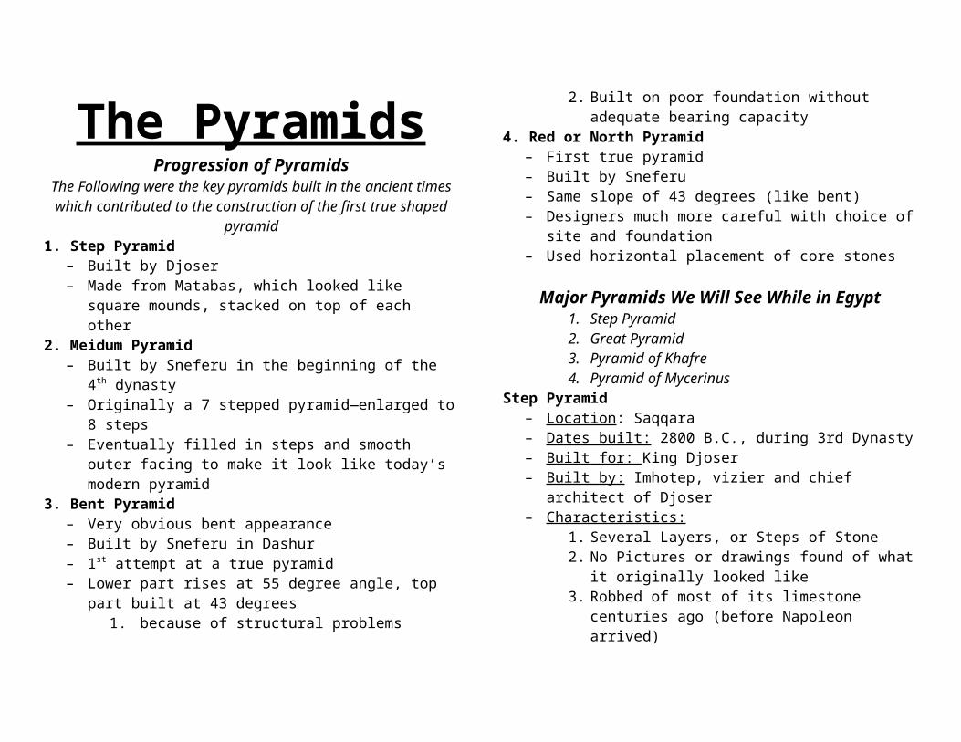
(before Napoleon arrived)4. Masonry and stonework of pyramid are poorer
quality than other pyramids like the great pyramid. 1. Smaller blocks-loosely stacked inwards2. Leaning Layers3. Backfilled with sand dirt and clay mortar
Great Pyramid– Location: Giza– Dates Built: 2579-2566 BC, 4th Dynasty– Built for: King Khufu- Son of King Sneferu who built bent
and red pyramids in Dashur– Built by: Hemiunu- Khufu’s vizier– Characteristics:
1. Largest Pyramid ever built1. 481 feet high—1 ½ football fields2. 756 feet base3. 2.3 million blocks of stone4. All corners within one inch of the cardinal
directions5. 2 Galleries & 3 Chambers Inside
2. Nicknamed “Horizon of Khufu”because built solely for the afterlife of Khufu
3. Tallest structure in the World until 1885 when the Washington Monument was built
Khafre’s Pyramid– Location: Giza– Dates Built: 2558-2532 BC– Built for: Khafre, son of Khufu– Characteristics:
1. Second greatest pyramid at Giza1. About 471 feet high—Not quite as tall as
Khufu’s (10 ft shorter)2. Made from limestone and red granite3. Attached to the Great Sphinx4. Best preserved funerary complex and mortuary
temple in Giza5. Some outer casing stones still remain

Menkaure’s Pyramid– Location: Giza– Dates Built: Undetermined – Built for: Menkaure, Son of Khafre, grandson of Khufu– Characteristics:
1. Smallest of the three pyramids in Giza1. 215 feet high2. 344 foot base
2. Great example of pyramid construction because of the red granite casing stones that were used on the lower courses
1. May Casing stones survived---allowed for great speculation on how pyramids were constructed
3. Marked the end of immense pyramid construction1. No more structures of such scale and
grandeur ever built again
Pyramid Complex at GizaMap from http://www.world-mysteries.com/alignments/gizamap.jpg
Egyptian Antiquities MuseumEllen Kramer
Entrance fee (20 LE)Mummy Hall fee (40 LE)
Not part of the tour, but encouraged to seePhotographing fee Hours: 9:00AM-2:00PM
1. Camera, without flash (10 LE)2. Video camera (100 LE)
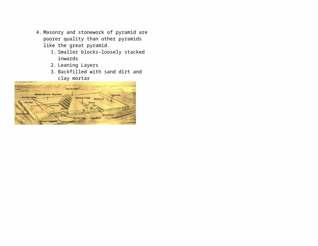
Other areas of the Museum*Bank is in southeast entrance. *Cafeteria is in right side to the main entrance.*Post office in southeast corner.*Book shop in the main entrance on your left side.*Gift shop next to the Bookshop.*Library on the southwest corner. *Toilet on the mezzanine of both stairs, the Southeastern & the southwestern. *Check room on the left side at the main entrance.
Ground Floor: History of Egypt -contains more of the big and heavy objects of the periodsFirst floor -contains more of the smaller objects from tombs and sitesSeven sections of the Museum going clockwise around the museum of both floors
*Section 1: Tutankhamen objects, Jewelry, Tanis objects*Section 2: Predynastic and Old Kingdom objects
(10,000-2130 BC)
*Section 3: Middle kingdom period and objects
-golden age of literature*Section 4: New kingdom period and objects
Akhenaton: monotheist pharaohRamesside PeriodRoom 29: contains “Books of the Dead”
*Section 5: late period and Greco-Roman period*Section 6: papyrus and coins of different periods*Section 7: sarcophagi and scarabs
Hall of Royal MummiesHouses 11 kings and queens
Saqqara*Imhotep museum
Fee: (free)
Saqqara is the site of the Step Pyramid and the funerary complex of King Djoser, the Pyramid of Unas, the Teti Pyramid, Old Kingdom tombs with scenes of daily life, and much more. Being the oldest of the 97 pyramids, Saqqara is a section of Memphis during the Old Kingdom. The Step pyramid and funerary complex of Djoser was made by Imhotep and is extremely important in the creation of the pyramids. The pyramid of Unas is famous for its pyramidal texts. These are written spells that help the pharaoh go back and forth from the heaven to the burial chamber. The Teti Pyramid was found in 1881 and is north east of Djoser’s pyramid.
Behind the Pyramids
The Step Pyramid was first created by King Djoser’s architect Imhotep. Starting out as mastabas stacked on top of one another, the ending result was the Step pyramid. Imhotep’s reasoning behind the design was to praise the gods and his pharaoh. Thus, Imhotep was also a high priest and a council member to the pharaoh. Yet because Imhotep was a high priest, he wanted a few changes to take place in the religious aspects of the pharaohs. Before the creation of the pyramids, the Egyptian’s assumed the pharaohs descended into the netherworld after they died. Imhotep wanted to change this aspect. He wanted the pharaohs to ascend into the Field of Reeds. So the pyramids are known as the “Stairway to Heaven.” Once the pharaoh’s ascended into heaven, they became the stars in the night’s sky.
Map of Saqqara
OzymandiasPercy Bysshe Shelley (1792-1822)
I met a traveller from an antique landWho said: Two vast and trunkless legs of stoneStand in the desert...Near them, on the sand,Half sunk, a shattered visage lies, whose frown,And wrinkled lip, and sneer of cold command,Tell that its sculptor well those passions readWhich yet survive, stamped on these lifeless things,The hand that mocked them, and the heart that fed;And on the pedestal these words appear:“My name is Ozymandias, king of kings:Look on my works, ye Mighty, and despair!”Nothing beside remains. Round the decayOf that colossal wreck, boundless and bareThe lone and level sands stretch far away.
Five Pillars of Islam1. There is no God but Allah, and Mohammed is His
prophet.2. Prayer five times daily, facing Mecca.3. Alms-giving to the poor and needy.4. Fasting sun-up to sun-down during Ramadan
(ninth month of lunar calendar).5. Hajj, the pilgrimage to Mecca.
Egypt
Cory R. Mueller
Egyptian Pound
Known in Arabic s the gunaih (el-Gunaih) the Egyptian Pound was first issued in 1834 by a royal decree. The royal decree stated that the currency was based on a bimetallic base- meaning the value of the monetary unit can be expressed with a certain amount of gold or silver. This led to the gold standard (1885-1914). Like the United States, the currencies are used as a unit of account and are backed by the government based on a specified weight of gold. The current exchange rate is 1 USD to 5.70 EGP or 1 EGP to .1755 USD. The inflation rate for the country is currently at 6.5%. This is more than double the United States inflation rate (based on 2006 estimates).
Cuisine
Egyptian cuisine consists of local culinary traditions such as Ful Medames, Kushari and Molokhia. Ful Medames are often eaten at breakfast. Consisting of fava beans slow cooked in a copper pot (the copper brings out a stronger flavor) that have been partially or completely mashed. The dish also consists of olive oil, onion, chopped parsley, garlic and lemon juice. It is typically eaten with an Egyptian bread or pita. Bread is accompanied with most Egyptian meals. The local word for bread is Eish Masri which means life. Though originally a peasant food, it has become a part of daily Egyptian’s diets. It is a very filling dish, with many describing it as being like “a stone in the stomach.” It is especially popular during Ramadan, or the month of fasting. Garlic and onion are used frequently in Egyptian foods.
Other popular dishes include Kebab and Kofta, consisting of lamb meat, chops and minced meat on skewers grilled on charcoal. Egyptians are famous for stuffing spicy rice in vegetables like green pepper, aubergines (eggplant), courgettes (zucchini) and tomatoes to make Mashi. Kushari is normally eaten in specialty Kushari restaurants that serve little else. It consists of base rice, black lentils, chickpeas, macaroni, and a spicy topping of Egyptian garlic, vinegar, and spicy tomato sauce. Small pieces of deeply fried onions are commonly put as an extra topping. This dish is among one of the most common and popular within the country. Tourists are drawn to its tastes, and the starches are easy and delicate on foreigner stomachs.
The Mosque of Muhammad Ali
Though certainly not one of the most ancient mosques in Cairo or even one of the most historic, but because of its shear size and location, the Mosque of Muhammad Ali is one of the most popular Islamic mosques among tourists. The mosque is situated in the Citadel of Cairo in Egypt and was built by Muhammad Ali Pasha between 1830 and 1848 and not completed until 1857. It is sometimes referred to as the Alabaster Mosque due to its extensive use of that stone on some of the exterior walls and other surfaces.
Situated on the summit of the citadel, the ottoman mosque is the largest to be built in the first half of the 19th century. The mosque was built in memory of Tusun Pasha, Muhammad Ali’s oldest son, who died at a very young age in 1816.Muhammad Ali tore down the previous remains of Mamluk palaces to make room for the mosque. The palaces were considered at one time to be the most impressive buildings in Cairo (Napoleons Scholars). It

should be noted that the mosque is not the typical structure in Cairo. The architecture comes from the Mamluk to the lake Ottoman period. The mosque would become a symbol of the city, even though it is the least Egyptian monument within the Citadel.
The complex consists of two parts; the mosque proper to the east, and the open courtyard to the west. In one of the chambers within the mosque, small lamps are hung in the middle of the praying area, as well as just above the main dome of the mosque. On the west wall of the courtyard is an iron clock, presented to Muhammad Ali by the French King Louis Philippe, with a tea salon on the upper level. The tower itself looks oriental, so don’t be surprised that it looks out of place. The clock was given as a gift in exchange for the obelisk now in the Palace de Concorde in Paris. Needless to say, the clock has never worked.
Muhammad Ali Pasha was buried in a tomb carved from marble in the courtyard of the mosque. His body was transferred here from Hawsh al-Basha in 1857.
Valley of the Kings
The Valley of the Kings is a valley in Egypt where for a period of nearly 500 years from the 16th to 11th century B.C, tombs were constructed for the kings and powerful nobles of the New Kingdom. The valley stands on the west bank of the Nile River, across from Thebes (modern day Luxor). The area has been a focus of concentrated archaeological exploration since the end of the 18th century. One of the most famous archeological discoveries is that of the tomb of King Tut (with its rumors of the Curse of the Pharaohs).
The Curse of the Pharaohs refers to the belief that any person who disturbs the mummy of an Ancient Egyptian pharaoh is placed under a curse and will die shortly after. Many tombs of the pharaohs have curses written on or around them, warning against entering. The belief was brought to attention in the 1920’s after some members of an exploration team died after opening the tomb of King Tut.
The Valley was used primarily for burials from approximately 1539 BC to 1075 BC, and contains at least 63 tombs. Despite being named Valley of the Kings, it also contains the tombs of favorite nobles as well as the wives and children of both nobles and pharaohs. The tombs were typically constructed and decorated by the workers of the village of Deir el-Medina, located in the small wadi between the Valley of the Kings and Valley of the Queeens. The usual tomb plan consisted of a long inclined rock-cut corridor, descending through one or more halls to the burial chamber. In the earlier tombs, the corridors turn through 90 degrees at least once. This layout is known as the bent axis, and after the burial the upper corridors were meant to be filled with rubble, and the entrance to the tomb hidden.
The majority of the tombs were decorated with religious texts and images. The early tombs were decorated with scenes from the Amduat (that which is the Underworld), describing the journey of the sun-god through the twelve hours of the night. From the time of Horemheb, tombs were decorated with the Book of Gates, which shows the sun-god passing through the twelve gates that divide the night time, and ensure the tomb owner’s safe passage through the night.
The tombs are numbered based on the time of discovery. For example, the first tomb discovered was tomb number one. The modern abbreviation “KV” stands for Kings Valley. Most of the

tombs are not open to the public (16 of the tombs can be opened, but they are rarely open at the same time), and officials occasionally close those that are open for restoration work. The West Valley has only one open tomb – that of Ay – and a separate ticket is needed to visit this tomb. The tour guides are no longer allowed to lecture inside the tombs and visitors are expected to proceed quietly and in single file through the tombs. This is to minimize time in the tombs, and prevent the crowds from damaging the surfaces of the decoration.
The Egyptian belief that “To speak the name of the dead is to make him live again” is certainly carried out in the building of the tombs. The king’s formal names and titles are inscribed in his tomb along with his images and statues. Beginning with the 18th dynasty and ending with the 20th, the kings abandoned the Memphis area and built their tombs in Thebes. Also abandoned was the pyramid style of building. Most of the tombs were cut into limestone and built in a similar manner: three corridors, an antechamber and a sunken sarcophagus chamber. These catacombs were harder to rob and were more easily concealed. Construction usually lasted six years, beginning with new reign. The texts in the tombs are from the Book of the Dead, the Book of the Gates and the Book of the Underworld.
The Valley of the Kings is divided into two sections: the West Valley and the East Valley. The East Valley is the area that is most visited by tourists. The West Valley contains only one tomb open to the public, Ay, the successor of Tutankhamun.
* Ramesses IV – Three white corridors descend into the sarcophagus chamber in this tomb. The chamber’s ceilings depict the goddess Nut. The lid of the pink granite sarcophagus is decorated with Isis and Nephthys, which were meant to serve as guardians over the body. Their duties fell short, however, as the
tomb was robbed in ancient times. Originally, the priests placed the sarcophagus in Amenhotep II’s tomb in order to hide the body, which was a common practice.
* Ramesses IX – Two sets lead down to the tomb door that is decorated with the Pharaoh worshipping the solar disc. Isis and Nephthys stand behind him on either side. Three corridors lead into the antechamber that opens into a pillared hall. The passage beyond leads to the sarcophagus chamber.
* Merneptah – the steep descent into the tomb is typical of the 19th dynasty. The entrance id decorated Isis and Nephthys worshipping the solar disc. Text from the Book of the Dead is located in the pillared chamber, along with scenes of the sky goddess, Nut.
* Ramesses VI – Originally built for Ramesses V, this tomb has three chambers and a fourth pillared chamber was added by Ramesses VI. Complete texts of the Book of the Gates, the Book of the Caverns and the Book of Day and Night line the chambers. Portions if the Book of the Dead are located in the pillared chamber, along with scenes of the sky goddess, Nut.
* Ramesses III – The tomb is sometimes referred to as the “Harpers Tomb” due to the two harpers praying to the gods in the four chambers. Ten small chambers branch off of the main corridors. These were for the placement of tomb furniture.
* Seti I – The longest tomb in the valley, 100 meters, contains very well preserved reliefs in all of its eleven chambers and side rooms. One of the back chambers is decorated with the Ritual of the Opening of the Mouth, which stated that mummy’s eating and drinking organs were functioning properly. Believing in the need for these functions the afterlife, this was a very important ritual. The sarcophagus is now in the Sir John Sloane Museum in London.

* Tuthmosis III – The approach to this unusual tomb is an ascent up wooden steps, crossing over a pit, and then a steep descent down into the tomb. The pit was probably as a deterrent to tomb robbers. Two small chambers, decorated with stars and a larger vestibule are in front of the sarcophagus chamber, which is uniquely rounded and decorated with only red and black.
* Amenhotep II – In this tomb, a steep flight of stairs and a long unadorned lead to the sarcophagus chamber. Three mummies, Tuthmosis IV, Amenhotep II and III, and Seti II were found in one side of the room and nine mummies were found on in another.
* Horenheb – The construction is identical to Seti I’s except for some of the inner decorations.
* Tutankhamun – The royal seal on the door was found intact. The first three chambers were unadorned with evidence of early entrance through one of the outside walls. The next chamber contained most of the funerary objects. The sarcophagus was four gilded wooden shrines, one inside the other, within which lay the stone sarcophagus, three mummified coffins, the inner one being solid gold, and then the mummy. Haste can be seen in the relief and the sarcophagus, due to the fact that Tutankhamun died at age 19 years of age following a brief reign.
KV 1 Ramesses VIIKV 2 Ramesses IVKV 3 Constructed for a son of Ramesses IIIKV 4 Ramesses XIKV 5 Sons of Ramesses IIKV 6 Ramesses IXKV 7 Ramesses IIKV 8 Merenptah
KV 9 Ramesses V/VIKV 10 AmenmesesKV 11 Ramesses IIIKV 13 BayKV 14 Tausert/SetnakhtKV 15 Seti IIKV 16 Ramesses IKV 17 Seti IKV 18 Ramesses XKV 19 MentuherkhepshefKV 20 Thutmoses I/HatshepsutKV 21 Two queensWV 22 Amenhotep IIIWV 23 AyWV 25 Akhenaten (?)KV 34 Tuthmosis IIIKV 35 Amenhotep IIKV 36 MaiherperiKV 38 Tuthmosis IKV 43 Tuthmosis IVKV 45 UserhetKV 46 Yuya and ThuyaKV 47 SiptahKV 48 AmenemopetKV 49 – 52 AnimalsKV 55 Amarna CacheKV 57 HoremhebKV 62 Tutankhamun
LuxorSometimes called the ‘Living City’ or ‘The world’s largest open air museum,’ the present day city of Luxor sits on the East bank of the Nile across from the Valley of the Kings. It has a population of around 150,000 people, and only has three main streets, (Sharia al-Mahatta, Sharia al Karnak, & Cornichehed.) Resting on the site of the ancient city of Thebes, this area was the capital of Egypt during part of the Eleventh Dynasty (Middle Kingdom) and most of the Eighteenth Dynasty (New Kingdom.) Areas of interest in or near the city include: The Temple of Luxor, the Luxor Museum, the Temple of Karnak, the Mummification Museum, and the Winter Palace Hotel.
Temple at Luxor
The earliest reference to Ipt ryst “Southern Sanctuary” comes from the reign of Ahmose around 1550 B.C. The text describes the mining of limestone for use in temples including the “Mansion of Amun in the Southern Sanctuary.” The earliest structural evidence originated during the time of Hatshepsut and Tuthmosis III in 1500 BC. Constructed most by Amenhotep III and Ramesses II, the temple of today has an overall length (from the first pylon to the rear wall) of about 623 x 181 feet. The first pylon, constructed by Ramesses II, stands 79 feet high and contains scenes from his military triumphs (especially the Battle of Kadesh). Only one of these 82-foot high red granite obelisks still remains. The other stands in the center of the Place de la Concorde, a gift from Egypt in 1835. Upon lowering this obelisk, they found Ramesses had inscribed his name on the bottom to ensure no other ruler took over his monument. The
inner sanctums of the temple begin with a dark antechamber. Roman stuccoes can still be seen covering the Egyptian carvings. At one point during Roman control, the area served as a chapel and local Christians were offered a final opportunity to renounce their faith and embrace the state religion. In A cache of 26 New Kingdom statues were found in the floor in the inner sanctum area in1989 and can be found at the Luxor Museum. To the east a small hall leads to Birth Room, so called because Amenhotop II claimed a divine birth. He alleged that Amun, disguised as Tuthmosis IV, entered the queen's chambers and breathed the child into her nostrils.

Temple at KarnakConstructed north of the city of Thebes, the Temple at Karnak was built over a span of about 1300 years. The ancient name of Ipet-isut, means “The Most Select (or Scared) of Places”. The temple complex contains three main temples and many outer temples. The main temple, the Temple of Amun, resides in the center of the complex. The Temple of Monthu is located to the north and the Temple of Mut to the south connected by an ally of ram headed sphinxes. Originally, a road of sphinxes connected this temple to the temple at Luxor. Layout:1 st Pylon - During the reconstruction by the Ptolemies the columns and façade were left unfinished.2 nd Pylon - Constructed by Ramesses II marks the entrance to the Hypostyle Hall.Hall – The construction began during the reign of Ramesses I, continued during the rule of Seti I, & was completed by Ramesses II. The hall ceiling is 82 feet high. The reliefs throughout the hall contain symbolism of Creation. The northern half are from the time period of Seti I and the southern half are from his son, Ramesses II. Transverse Hall- This hall lies beyond the Hypostyle Hall and contians the remains of the earliest sections of the complex that are still in existence. Third Pylon- This pylon was created by Tuthmosis I (father of Hatshepsut). The obelisk stands 70 feet tall and weighs around 143 tons. The next obelisk is the only remaining obelisk of Hatshepsut, which stands 97 feet tall weighing about 320 tons. Besides the Lateran Obelisk in Rome, this is the tallest standing obelisk.

6 th Pylon - Built by Tuthmosis III, this pylon marks the entrance to the Hall of records. Originally, this was the oldest part of the temple. The present sanctuary was built by the brother of Alexander the Great.
http://www.touregypt.net/karnak.htmhttp://www.virtourist.com/africa/luxor/10.htmhttp://touregypt.net/lxtmpl.htmhttp://en.wikipedia.org/wiki/Luxorhttp://www.touregypt.net/karnak.htmhttp://www.luxorguide.com/


The Nile
Iteru or Great River, the Nile allowed a successful and rich culture to develop and thrive in an otherwise inhospitable desert. Flowing 4184 miles though nine countries (White Nile: Uganda, Sudan, & Egypt; Blue Nile: Ethiopia, Zaire, Kenya, Tanzania, Rwanda, & Burundi,) the river has an average discharge of 300 million cubic meters a day. 90% of the water and 96% of the transported sediment originate in Ethiopia, and one of the two main tributaries, the Blue Nile originates in Lake Tana in the country’s Highlands. Other tributaries of the Blue Nile include Tekezé, Atbarah, Sobat. The Blue Nile or Bahr al Azraq, so named because of the water color, flows about 850 miles to Khartoum, where it merges with the White Nile to become “The Nile.” Regarded as the ultimate source of the Nile, the

Ruvyironza is an upper branch of the Kagera River. After flowing through a series of lakes, joining other bodies of water, and taking different names the Ruvyironza becomes Bahr al Abyad or White Nile.Due to the monsoon rains in Ethiopia, the Nile flooded every year during the months of June through September. Termed the akhet or inundation, this season provided the rich soil need to help this civilization thrive. The other two seasons were peret (growing season) and shemu (the drought or harvest season.) Not only did the Nile provide the water and land necessary for survival, it also played an enormous part in the Egyptian religion. The Nile held so much importance, the people created a god, Hapi to care for care of the river and the flood cycle. Together, he and the Pharaoh controlled the cycle of the river. The Nile also held religious importance because it was considered a causeway from life to death and the afterlife. Following the path of the god Ra (sun) and his cycle of birth and death, the east represented birth and growth, while the west side represented death. This belief is evident in the construction of some of their cities, Luxor for example. The living city resided on the east banks and all the tombs were placed on the side that symbolized death, the west bank.
Aswan Dam
The Aswan Dam (Lower) was built by the British to help control the flooding of the Nile. However, upon finding the damn inadequate for a third time and raising the height again (first in 1907-1912, then in 1929-1933), the decision to build a new dam was made. With construction beginning in 1960 and completion on July 21, 1970, the second dam built, called the Aswan High Dam, is 3,600 m in length, 980 m wide at the base, 40 m wide at
the crest, 111 m tall and contains 43 million m3 of material. Lake Nassar, the reservoir created behind the dam holds 111km3 of water and has a surface area of 5,250 km2. With the creation of this body of water, archaeological sites risked submergence. Under UNESCO, 24 sites were moved to safer locations, Abu Simbel to name one. With Power generation beginning in 1967, electricity was available to many Egyptian villages for the first time. The dam helped dampen the effects of two dangerous floods in 1964 and 1973 and droughts in 1972-73 and1983-84. It has provided jobs in the fishing industry in Lake Nasser; however, some worry about the fertility of the soil because the dams filter much of the silt out.
http://www.nileriver.com/nile/main.htmhttp://en.wikipedia.org/wiki/Nile