Embed Size (px)
Citation preview

1
Memories of Troopers Hill
&
Former Industrial Sites & Dwelling Houses along the
River Avon at Crews Hole Conham & Hanham

2
Introduction Friends of Troopers Hill are pleased to be able to publish this document that we are sure that will be of interest to anyone who knows the Avon Valley and East Bristol. The original was hand written by Tom Fry who also drew the various illustrations. In the late 1980s Tom handed a copy to Raymond Holland who had become interested in the history of the area through working at the Tar Works. Raymond lent his copy to Friends of Troopers Hill in 2007 and with his permission one of our members, Margaret Watson, kindly agreed to type it. Through a letter to the Bristol Evening Post we have been able to contact Tom’s family and his son has kindly given his permission for us to publish it. The illustrations have been scanned and inserted in the typed text in the positions that they appeared in the original. Tom’s hand-drawn maps are included at the end of the document and show the locations referred to in the text. This is only an extract of a larger document and we can only hope that the remainder will one day come to light. You can find out more about the Friends of Troopers Hill via our website at www.troopers-hill.org.uk From the ‘Hill History’ page on the website you can also download Raymond Holland’s account of the history of the Tar Works. Rob Acton-Campbell Friends of Troopers Hill Feb 2008

3
TROOPERS HILL Troopers Hill (Trubody’s Hill on 17 Century maps) was the foremost playground for all the boys living near it. When young we had small dens in the holes of the quarried rock faces. We called these holes “Caves” and we lit fires in them and camped in them for days on end. In the top cave a favourite sport was for some boys to get above the cave and flush heaps of loose rock over the top of it with the feet. The boys inside would enjoy this deluge of “rain” as we called. One day a boy named Arthur fell over the edge along with the loose rock. We escorted him home with a badly cut head. We also played around the chimney stack on the top of the hill, and also the long half-round flu made of iron plates which carried the smoke to it, and snaked up the surface of the hill from the Crews Hole Chemical Co’s premises at the riverside works, about two hundred and fifty feet below. Trooper’s Hill was sometimes called Donkey Island on account of the number of donkeys that used to graze there. These were used by local cottagers to pull small carts which they used in their small hawking or carrying businesses. One such resident was Mr Macey who lived in an odd shaped house called ‘The engine house’ which formerly stood half-way down Trooper’s Hill Road. Another well known donkey owner, was Charley Hadley of Cassey Bottom Lane. He used to sell red sand which he hawked around Crew’s Hole and Whites Hill. His cry of ‘Wan any sand’ could often be heard. The cottagers bought it for one penny a bucket to sand over their floors which in those days were made of local flagstone in all the downstairs rooms. At this time – around 1910, Father used to warn me of the dangers of the hill, telling me that it was all undermined. Indeed the collapse of an old sloping shaft occurred in the floor of the main quarry, the sides of which had been walled with mortared stone. It may truthfully be said that the hill is the best remaining remnant of the Kingswood coal-field. For one may still trace the sites of at least six shallow mines there. There were around four hundred such mines in the Kingswood Forest area at the beginning of the nineteenth Century – or so it has been stated.

4
The main coal seam reaches the surface along the west margin of the hill. I saw it exposed in 1968, before tipping of Corporation waste there. It was five or six feet in thickness. An eighty-five years old man told me in 1971 that his Grandfather worked the last ‘tub mine’ (ie – a shallow mine worked by means of a tub on a rope hauled up by a small windlass). The side of it was in the eastern corner of Avon View Cemetery near the top of Cosham Road close to Beaufort Road. The date was around 1870. I believe most shallow mines were worked with the aid of a horse-gin (ie a horse driven round in a circle attached to a rope and windlass for hauling up the coal). Traces of the circuits made, may still be seen on Troopers Hill. Depths of all vertical mines were restricted before the invention of the wire rope, but a recent shaft was uncovered at nearby Dundridge Gardens which was plumbed to a depth of two hundred feet (1970). At this time my father, Tom Fry senior worked at the Fire Clay company works at Crews Hole, near the bottom of Lamb Hill. Here the grinding pans, as well as the moulding shop and the kilns were situated. The company mined their clays by means of several adits driven into the valley side in a northward direction. One of these adits was at the works itself, and the other was situated near the Crews Hole road on the southwest corner of Troopers Hill. As I often took fathers lunch to him, I often saw the clay miners pushing out the trams loaded with fireclay. They wore hard hats with lighted tallow candles fixed on them. I also visited the works, and I remember picking up the clay off-cuts and keeping these as treasures. They always weighed the clay which they brought out from Troopers Hill and there was a weighbridge there for this purpose (1907). Father told me they were not allowed to take the coal they found while mining the fire clay, because they did not own the coal mining royalties – I believe these belonged to the Ecclesiastical Commissioners but I am not sure about this. Most of the working directors were local business men of more than usual acumen and ability. Among them were Messrs Slade, Evans, Lawson and Hall. The terra cotta goods produced

5
were fine examples of their kind, and one may see examples on the facings of many houses at and near St George. The works closed in 1913-14.
ACCIDENT AT TROOPERS HILL During a miners strike in 1913, many miners of the Bristol coal field spent their time in digging for coal at places where the coal seams were near the surface. One of these diggings was on the slope of Troopers Hill, near the lower end of Troopers Hill road. I was returning with four other boys from the river bank and we went up to the diggings. It was Saturday afternoon and the diggers had gone home and had taken the coal they had dug, with them. We were playing around and exploring the hole the men had made. Because the coal seam was very thin, a deep narrow hole had been dug. Suddenly the ground collapsed into the hole when C.Whittingham and W. Burfitt were inside. Hearing our shouts for help several men hurried towards us from the cottages below. Soon the men were digging and a small crowd collected including the mother of W. Burfitt. After half an hour W. Burfitt was brought out but he was dead. His body was carried down to his home, followed by his distraught mother.

6
Fifteen minutes later C. Whittingham was brought out. He recovered immediately, and insisted on walking across the hill homeward, followed by his mother, who had been fetched by some boys. It is possible that had the modern methods of resuscitation been applied W. Burfitt may had recovered. He was only twelve. As for C. Whittington who was a year older, he lived until he was aged sixty-nine after a full life and passed away in 1970.
As one may have gathered Charlie was an independent character and that is perhaps the reason we never became close friends. I always looked to go to Sunday School with him because he always had generous collection money for the plate. Half of this he spent on a tasty variety of bonbons, at Mrs Taylor’s or Mr Little’s shop. He was seemingly without scruples, and a gambler by nature. He often led a small gambling school of boys in a hollow on Trooper’s Hill, and he invariably held the “Bank” although the coins were usually halfpennies. An incident involving fireworks I have already told on page [?] Charlie was very useful to me when I took up Geology as a study when I was sixteen. We were then working at the Wagon Works together. As he was adept at woodwork, and we could buy off-cuts of timber there for sixpence a bundle, I commissioned him to make my first cabinet for specimens. When finished it held twenty-four drawers, and the “Carcase” was fashioned out of a large bacon box. It cost me five pounds altogether because I had to help Charlie buy some necessary tools. We painted it in a maroon shade with a slate-grey interior. Charlie finally entered the motor car business and became a manager for a large Bristol company.
FURTHER ADVENTURES AT TROOPER’S HILL
Rival groups of boys would resort to Trooper’s Hill to fight battles with stones, of which there was a super-abundance lying

7
about on the old quarried surface of the hill. There was the White’s Hill and Crew’s Hole gangs, and also boys from St George and Whitehall. The gangs would stand on different tumps and throw and often fight running battles. I was struck three times in one battle. The worst cracks I received, was once when I stood in front of Fred when he was throwing. I saw the hill make several complete revolutions on that occasion. Another time I was struck on the head by a boy throwing at random from above me. In revenge I ran up to him and took his toy gun away and smashed it on a rock, and walked away leaving him in tears. One of the bravest groups were the Hooper brothers of Conham Vale. They accepted myself and Charlie into their gang after they had caught us near their home and tied us up to trees there. With the Hooper’s I charged up Trooper’s Hill in the face of the Whitehall gang, who were throwing straight into us. Of course – not being so brave as the others I urged them on from the rear shouting encouragement and waving a flag which had red lions on it. The bravest boy was Walt Hooper: he fearlessly charged into our rivals, parrying the flying stones with a stick he was carrying. Other happenings on the hill included waiting for Uncle Bill – who had a poor appetite – as he returned from work across the hill. He usually kept part of his uneaten lunch for me. Although it was invariably fat ham with plenty of mustard on it, it was very welcome nevertheless. The old stack still standing on the hill top, at that time belched out smoke which was carried up the side of the hill from Crews Hole Chemical Companies works, by means of a long flue formed by large half round steel plates. The flue was a source of amusement to us, for we sat on the steel plates – which were hot during cold winters days, or else slid down them. Once they had to haul out Mr Macey’s donkey when it had slipped in the broken flue - a very precarious job because it was covered in hot soot. Other sports included catching the numerous grass hoppers and small butterflies which were abundant among the wiry grass, ragwort, and yarrow, during the summer days. We also paddled in the pools formed in the clay patches during heavy

8
storms. Sometimes the more dedicated boys played football on the small flat area on the north-east corner of the hill. This area was the site of a temporary small-pox isolation hospital (circa 1880) according to my father. During 1913 all the dangerous quarries on the hill were fenced in with wire and iron posts, as a project to relieve unemployment. All vestiges of this has since disappeared. Troopers Hill was formerly Trubodies Hill (on 1860 map), and previously Ghosthills (on 1650 map). The present course of Trooper’s Hill Road, was called “Ghosthills Gully” on 1650 map, which was later debased to Gossey Bottom by common usage. Name still preserved as Cassey Bottom on present day maps 1976. Note – Father said “Ghost” was an early term for “Gorse” – the thorny plant, which originally grew on the hill.
MR MACEY’S HOUSE “ENGINE HOUSE” HALFWAY DOWN TROOPER’S HILL ROAD 1912. DEMOLISHED IN 1960. A VERTICAL SHAFT WAS DISCLOSED BENEATH IT. Probably site of colliery shaft working the large 6 ft coal seam of the area MAP NO. 12 DRAWN FROM MEMORY

9
REMAINS OF INDUSTRY ALONG THE RIVER SIDE BETWEEN NETHAM AND HANHAM MILL
(1 South Bank)
FORMER GLASS WORKS AT CREW’S HOLE (CIRCA 1700?) PRESENT ? 1600 BUILDING TO RIGHT WAS FORMER LAMB INN
FANCIFUL SKETCH FROM FORMER RUINS MAP NO 17.
The industry has changed continuously through former centuries. I have some little knowledge from my own observation without recourse to the known records of the area. The south bank shows very little evidence of former work, previous to the present important paper and board factory which extends for one and a half miles. It is probable that the Avonside Brick and Tile Work occupied the hollow area on the south side of the Netham Bridge near the Netham railway sidings. Here the face of rock is of red Kemper marl or Sandstone. River silts would be available for use also. Messrs Pountney (more recently at Fishponds, but now closed ? 1950) had an early pottery factory (? Fifteenth century) on the slope near to the river, on the site of the present St Anne’s residential estate. I saw part of a waste tip of unglazed broken china plates, that was cut through during the construction of

10
the lower end of Guildford Road in 1928. I also found my first undoubted Palaeolithic implements of “Drift Trype” upon the aforesaid site just before and during the road construction here. They were pronounced “Mousterian” by M. C. Burkitt (see University of Brisol Spelaeological Soc.s journal for 1928. The best find was a finely chipped ovate hand-axe in patinated (Grey) Greensand Chert four and half inches in length). The St Anne’s Well is still be seen nearby near St Anne’s brook. It is near the site of St Anne’s Chapel: said to have been visited by Queen Elizabeth 1st. Also upon St Anne’s former farmland, at the river’s edge there was St. Anne’s slipway (no ). Here barges were dragged up to the sheds and repaired, along with smaller craft by a dozen or more shipwrights and their apprentices. Most of the land at St Anne’s belonged to the Birchwood estate as late as 1912, and was owned by the Sinnot family.
ST ANNES SLIPWAY (Circa 1910)
DRAWN FROM MEMORY MAP NO. 18 There are no other traces of industry that I know of on the south side of the river between Netham and Conham Ferry, apart from quarrying of Pennant.
11
I have been told by my father that on the meadow on the opposite side to the Lamb Inn, that boxing contests with bare fists took place on Sunday mornings (circa 1880).
Industry on the North side of the Avon On this side there was The United Akali Co’s premises at Netham (later acquired by Imperial Chemical Industries Ltd). They imported Copper Ore, from Rio Tinto Spain, mainly to produce Sulphuric Acid, a vast quantity of this was produced in the 1914-18 War, when the works employed 1,000 men. Other products were washing Blue, Sal ammoniac, Hydrochloric Acid, and Washing Soda. Limestone was brought to the works from the firms quarry in the Avon Gorge, (Quarry 3, Left Bank), and used to produce Bleach, builder’s mortar and for other purposes. There was a huge waste tip at Netham, which was converted into Barton Hill Playing Fields when the works closed (Circa 1950). During 1940 I saw a Colliery shaft in the works which must have been the site of the former Netham Colliery. The former Pile Marsh Colliery at nearby Pile Marsh was occupied in 1912 by Grindell and Sons horse transport hauliers, and later (circa 1922) St Patrick’s Church and school was erected there. Further upstream adjoining Netham Works, there was the Lead Works belonging to Messrs Capper Pass. Their smoke stack (off Kepler Hill, now Blackswarth Road) was the tallest in the Bristol area. They had a clock tower near the river with a Kepler Clock in it. This was dismantled by thieves in 1920, when it was said to be 200 years old. The Lead works is said to have obtained lead ore from Leadhills in Scotland. I know that the firm was recovering lead from the waste of the Roman mines at Charterhouse-on-Mendip around 1860, as I was told by a farmer there who saw the works. It is therefore possible that some of the lead ore came from there. At Crew’s Hole, the Bristol Fire Clay Co. was producing terra cotta and fire bricks around 1910 and the works closed about
12
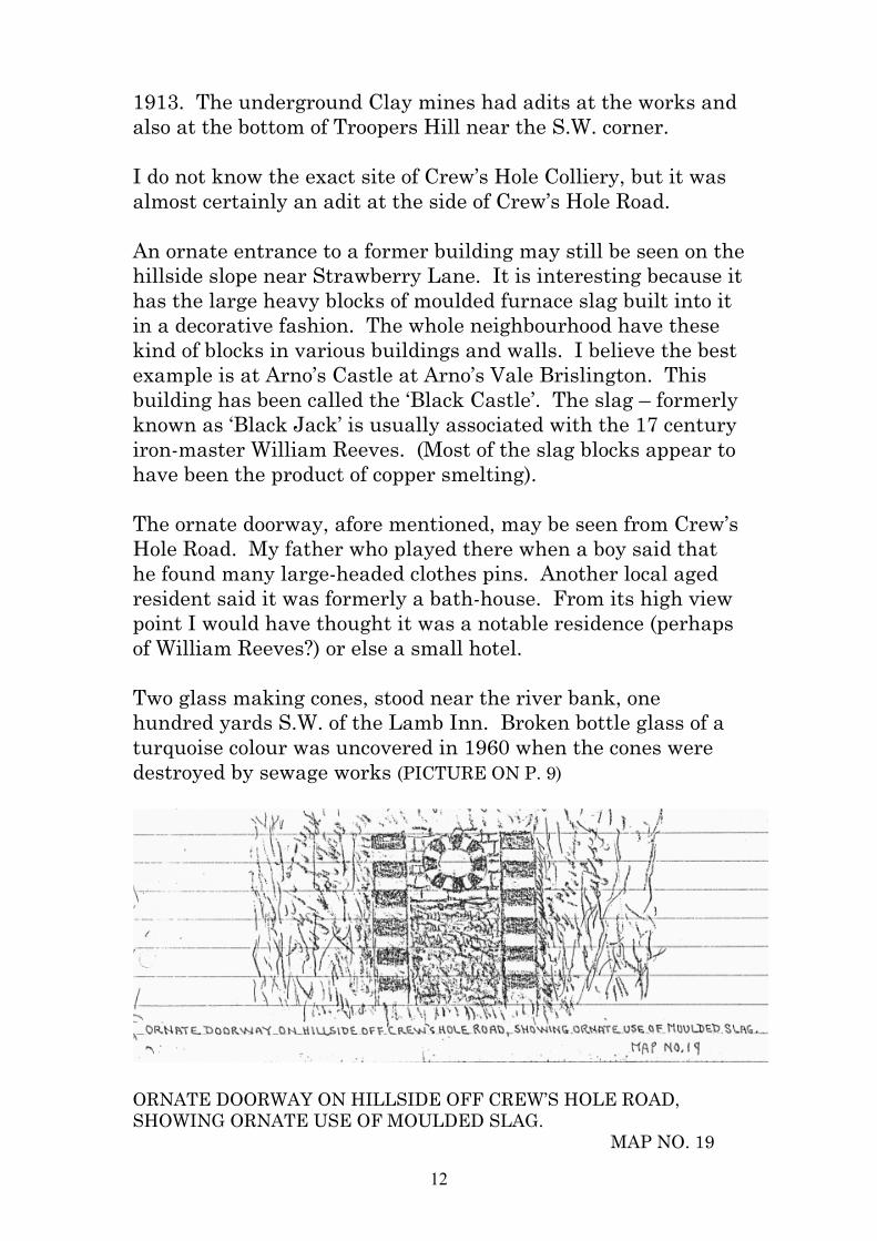
1913. The underground Clay mines had adits at the works and also at the bottom of Troopers Hill near the S.W. corner. I do not know the exact site of Crew’s Hole Colliery, but it was almost certainly an adit at the side of Crew’s Hole Road. An ornate entrance to a former building may still be seen on the hillside slope near Strawberry Lane. It is interesting because it has the large heavy blocks of moulded furnace slag built into it in a decorative fashion. The whole neighbourhood have these kind of blocks in various buildings and walls. I believe the best example is at Arno’s Castle at Arno’s Vale Brislington. This building has been called the ‘Black Castle’. The slag – formerly known as ‘Black Jack’ is usually associated with the 17 century iron-master William Reeves. (Most of the slag blocks appear to have been the product of copper smelting). The ornate doorway, afore mentioned, may be seen from Crew’s Hole Road. My father who played there when a boy said that he found many large-headed clothes pins. Another local aged resident said it was formerly a bath-house. From its high view point I would have thought it was a notable residence (perhaps of William Reeves?) or else a small hotel. Two glass making cones, stood near the river bank, one hundred yards S.W. of the Lamb Inn. Broken bottle glass of a turquoise colour was uncovered in 1960 when the cones were destroyed by sewage works (PICTURE ON P. 9)
ORNATE DOORWAY ON HILLSIDE OFF CREW’S HOLE ROAD, SHOWING ORNATE USE OF MOULDED SLAG. MAP NO. 19

13
Passing along Crew’s Hole road in an upstream direction, Trooper’s Hill rises on ones left with United Steel works formerly Butler’s Tar distillery on the right. At the junction with the bottom of Trooper’s Hill road the remaining ruin of a building known as an engine house is seen. The strongly built short smoke stack is the best preserved portion, and it has the large moulded blocks of ‘Black Jack’ slag built into it. (See further note: next page). Further along just before Crew’s Hole road runs onto the river bank some buildings incorporated into United Steels buildings, appear to have been the original Crew’s Hole church with a Church school. The later church is a small building near the “Engine House” mentioned above. The original church is now demolished. 1976. The large hollow containing storage tanks, at the eastern end of the works, was a flourishing quarry in sandstone in 1912 and it was called Abel Bruton’s Pennant Stone Works. Here one could see workers chipping the stone into kerb stones, flag stones, gate posts and other desired shapes. Soon after this time the industry declined.
Site of Colliery Crew’s Hole
FRAGMENT OF RUINED ‘ENGINE HOUSE’ AT JUNCTION OF TROOPERS HILL RD & CONHAM RD. SHOWING COURSES OF “BLACK JACK” BUILT INTO THE SMOKE STACK. MAP NO. 20

14
A second ‘Engine House’ which formerly stood at the side of Trooper’s Hill Road about one third of the distance up this road is mentioned on p 8. As I was informed recently, 1978, by Ewart Lovell of Hanham that a colliery shaft was visible and seen by his father at the bottom end of Trooper’s Hill road, it is probable that both engine houses mentioned, are on the sites of former collieries. From the end portion of the Chemical works there is no industrial sites going upstream until the point where the road diverges from the river bank (Conham Road). There was however several cottages at the foot of the wooded slope. One of these was at the halfway distance. Not only was many blocks of Black Jack in this building but the date was prominently moulded into it. It was 1729. Obviously the “Black Jack” slag was being made at that time. This building was demolished about 1960. Where the road diverges, there was once the ruin of a small factory with access to the river bank. I do not know what the use of this site could have been. Moulded ‘Black Jack’ is seen capping part of the old boundary wall.
COTTAGE FORMERLY IN CONHAM ROAD (CENTRAL PART) BUILT IN 1729. MAP NO. 21

15
A well preserved ancient house, stands at the entrance to Conham valley (a side valley). This is now the oldest building here-a-abouts. When a friend (Mrs Whiteley) saw it in 1974 she remarked that it had every appearance of a mill-house. This could very well be the case, as a small stream (now placed underground) runs alongside. There is also an area of ground which never appears to have been built upon which would have been a good site for a mill-pond (S no. ?) The small stream which runs down beneath, was larger than it is now (1977) when I was a boy. Last summer it dried completely. It rises at Kingswood where it is known as Stradbrook.
ANCIENT COTTAGE THOUGHT TO HAVE BEEN A WATER MILL (C 1700?) LOWER ENTRANCE TO CONHAM VALE CONHAM ROAD HORSE CHESTNUT TREE: OLDEST TREE IN NEIGHBOURHOOD MAP NO. 22

16
ANCIENT COPPER WORKS RUINS AT CONHAM MAP NO. 23

17
PLAN OF RIVER AVON AND ENVIRONS CONHAM BRISTOL 1977 SHOWING SITE OF ANCIENT COPPER SMELTING WORKS Continuing onward along the short lane leading to Conham Ferry, at the highest point of the lane the entrance to Conham Hall was on the right. This building, quite a plain residence built of local pennant stone, is claimed to have been one of the oldest buildings in Hanham. It was demolished (circa 1960). There is at present a rubbish tip on the site.

18
On the waste ground to the left side, there is still a considerable ruin of what was once an ancient smelting works. This may have been the Copper ore smelter said to have been worked near Hanham by ? Captain Copely who also had works at Warmley (Braine’s History of Kingswood Forest). I found what I considered to be copper ore slags when Ferry Lane was dug up a few years ago. As will be seen by the drawing on the previous page, the south building was strongly constructed with many arched openings in the outer walls and also in the parting walls of the rooms. This I believe was the foundry shop adjoining the smelter. The building on the north side was a taller structure – as much as forty feet high, and may have been of two stories. The amount of moulded “black Jack” built into the sides of the arches and in the quoins (corners) shows that these slag blocks were being produced when the building was constructed. Lower down the slope and close to the lane there is a long arch which although now buried in rubbish, was still sound when I was a boy for we used to shelter there. This arch may have been the means of access and egress for the works, as being the easiest way of conveying materials to and from the river-side wharf where the landing area is still easily made out. Conham Hall was probably the home of the owner or managerial authority of this factory. The factory shows signs of destruction and rebuilding during its existence. When I was a boy part of it was occupied by a local family named Hillier. Some of the roadside boundary walls near the Works are still capped by moulded capping of “Black Jack”. This must have been produced locally, for I cannot imagine anybody carting this extremely heavy material very far just for the purpose of capping a wall, when local pennant stone was readily available. Other minor but interesting happenings near Conham Ferry (Beeses) are – (1) The site of the quarry formerly worked on the high face of rock above the main railway line (on south bank of river) where John Chidgey was killed (1877) whilst removing a

19
large stone from the railway line. A cottage built and given to his family by the public still stands in Memorial Road Hanham. (2) A carved pennant memorial stone used to stand as part of the boundary wall by the side of the towpath about fifty yards upstream from the ferry steps (north side). The information given was thus:- This stone was laid by William Scott Lawrence to Commemorate the awfully sudden death by lightning of William Hicks of Crew’s Hole, near this spot. Sinner prepare to meet they God.
FURTHER FEATURES MOVING UPSTREAM FROM CONHAM FERRY
Traces of excavations near the river bank immediately east of the ferry house were probably old workings for coal. More obvious coal workings were formerly to be seen at the top of the step behind the ferry house. On the Hanham side, one passes “The Hundred Steps” where there are some ruins of a disused sewerage works. A distance of about 150 brings one to the traces of a ruined stone crushing plant. This marks the last of the more important stone quarries. It was reopened and worked by Hayward and Wooster, between 1918 and 1925 when it closed down. A further ancient smelting works formerly stood a little further on. The works stood on the valley slope at about 100ft higher than the towpath and were set back against the quarried face. The kilns used for roasting the ore were still tolerably well preserved up to the year 1920. They were afterwards finally destroyed by sporadic quarrying. When I was very young (circa 1910) I remember seeing a clock tower belonging to the works. Even then it was being buried by tipping by Hanham Colliery, who had previously cut the works into two parts with their tramway incline which conveyed coal down to the riverside wharf. Part of the slag tip from the works is still to be seen. Searching this I found pieces of {Smithoorite Calamitine} an ore of zinc

20
which was worked extensively at Shipham on the Mendip hills and in other places near Bristol. The site of the works are passed over at the lower end of the recently established (1976) Panorama Walk. Map No 24. A further half a mile upstream, there is the foundation of a large building on the flat ground near the tow-path. It has always been a ruin except for a portion recently re-roofed for horse stabling. It has always been called “The Powder House”. Whether it was only a distribution centre for use by the numerous quarry workers, or whether gunpowder was made here I do not know. I think the latter is most probably. Some “Black Jack” is seen in a side wall. MAP NO. 25
FORMER SMELTING WORKS STILL PARTIALLY PRESERVED UP TO 1920. THE CLOCK TOWER DESTROYED BY HANHAM COLLIERY TIPPING 1910.
FANCIFUL RE-CONSTRUCTION FROM KNOWN RUINS MAP NO. 24
A little further on another smaller building is seen in an orchard close to the tow path. The site is close to Riverside. It is obviously a kiln for drying purposes. There is a drain outlet across the tow-path into the river. The low ground on which it stands is part of the river flood plain and it was called “The Withy Beds” by local people. The kiln could have been used for drying “Withies” or willow stalks for basket making, but this is only my conjecture. (OVER). Beyond riverside further raised

21
ground where there was once foundations is visible. (For position see Map No. 26). The next site is that of Hanham Mills which was formerly 1910 still a large and impressive ruin. Now very little remains of this ancient and important mill. It was used for raising water by means of wheel engine. The water was conveyed through hollow elm pipes to Bristol. Map no. 27. (Braine’s History of Kingswood Forest).
SMALL BUILDING SHOWING FIREPLACES (SIZE AT BASE 20X10 FEET) USE NOT KNOWN. POSITION – NEAR RIVER BANK, RIVERSIDE, HANHAM MAP NO. 26 As the adjoining field, known as “Withy Beds”. May have been used for boiling purposes. A further ruined building lies just above flood level near the river below Cleeve Wood. It was possibly a dwelling house. There was however an arched basement made of stone. In this we spent two nights during Easter 1918 and Easter 1919. There were three of us boys, Fred and George Britton and myself. Map No. 28 Note re p.81 Evening Post Aug 31 1977 “Portmeiron N Wales. Removal to this place of Colonnade of Arnos Court Bathouse. 1957 Arno’s Court was owned by William Reeve 18 Century Copper Smelter.” (Was this man the owner of the Copper Works) Note re p.86

22
Mr Ewart Lovell 1977 informed me that Sanigar (Bristol mentions a mill at Netham. Was this the means of pumping water derived from Hanham lock to the reservoir said to have been near Barrow Road, Lawrence Hill by Sanigar. p.79 Mr Lovell said his grandfather told him mine shaft was uncovered here in 1850. This must have been site of colliery.
23
Further Notes on River Avon Industries
These notes were written later than the above account and were attached to the front of the document handed to Raymond Holland.
(1) THE NETHAM CHEMICAL WORKS – T. R.
FRY When house building ceased at the out-break of the 1939-45 war, I went to work at Netham Chemical Works. The Works, which had been gradually run down, received a new lease of life and everything viable had to be kept in working order. The H.C.L. Plant and the Sulphuric Acid plant, was fully operational. The salt for the former was brought to the works by barges, each carrying 60 tons. The salt was hoisted by crane, and carried to the master furnace by trams, pushed by workmen. The residual salt-cake was afterwards trammed to a large store-shed. As occasion demanded, the salt cake was transferred to barges to be sent to Holland or elsewhere for glass making. As the war continued and demand ceased, the store of salt-cake built up. Following a fire which destroyed the salt-cake shed, exposure to the elements turned the store of salt-cake into a very hard mess. The Sulphuric Acid furnaces were fed by spent oxide from the gas purification plant at the Stapleton Gas Works. Pure Sulphur crystals were added as occasion demanded. The tall lead lined chamber of this plant was constantly being repaired by the team of Lead Burners and Carpenters. About this time (1940), the Ammonia plant was ceasing production. Elsewhere, on the east side of the works, lay the unused Copper Ore shed. There had been a disastrous fire here a few years previously which had destroyed one of the large chambers.
24
There was talk by the workmen about the former ‘Blue’ section of this plant which had produced ‘Blue’ used in washing clothes. The copper Pyrites formerly used was said to have come form Rio Tinto mines. After being processed, the burnt ore left the works by barge to be dealt with elsewhere. The Soda making plant was very busy during the war. The mother liquor was prepared in a large mixing tank, and then pumped into the Soda room. Here it was run into iron basins, which were about eight feet in diameter, where it was crystallized. These basins were known as ‘Soda Coons’. Packing the crushed soda was carried out by female labour. Ladies also worked at bottling acid by filling glass carboys packed in straw filled crates. There was talk of ‘working in the muriate’ by the men, but I did not see this process. There was little remaining of the former bleach department. Although when a boy I saw it working from Feeder Road, from the south side of the Canal. I remember the lime kilns, and the trackway up which they hauled the limestone from the barges. The limestone had been quarried from a special quarry on the Leigh woods side of the Avon Gorge. This quarry was worked by the firm and the limestone was said to be the most suitable for bleach making. Beside feeding the Bleach plant, the lime was also made into builders mortar which had a good local reputation. When I went to work at Netham in 1940, the Manager was Mr Polack. He organised the local defence volunteers known as the L.D.V., later known as ‘The Home Guard’. Our first introduction to this force was to dig a trench at Purdown on weekends. A night-watch system was introduced later. Mr Polack was followed by Mr Trotters as manager. After the war Mr Swain took charge, and it was he who organized the final run down and the demolition of the works. Other jobs were found, or offered to most of the younger workers, and the remainder took early retirement.

25
During a long illness, I was grateful to the directors of Imperial Chemical Industries, to have my full wages paid. Thirty bombs fell on the works property during the Blitzes, but the damage was repaired quickly, mainly by the Works staff. One bomb fell on the steel casing of the large remaining tall stack in Netham Road, but the chimney remained standing. The greatest bomb scare was when a 500lb one, fell and failed to explode a few feet away from “The Wagon and Horses” Inn close to the upper end of the works. All the works was evacuated. When it was uncovered by the soldiers at a depth of 20 feet, our manager Mr Polack, lost no time in going down the hole to inspect it. I have seen a photograph of Netham in its heyday, with 7 or 8 tall stacks showing. I realized then, that when I worked there in 1940, Netham had become nothing but a pale shadow of its former self.
(2) THE LEAD WORKS Adjoining the Netham works on the eastern side, was the lead works, whose property extended to Blackswarth Road. Said to have been worked by Messrs Capper Pass & Co. I remember the glittering bars of lead being loaded into the barges. The lead was said to contain an appreciable amount of silver. The first sources of the lead ore was probably Charterhouse on Mendip where Messrs Capper Pass were obtaining lead ore (Galena) from waste deposits left by the Romans. Another Bristol firm Mssrs Sheldon Bush, Patent Shot Co. was said to be working at the lead works, according to the British Association report for 1875. The works was notable for its clock tower with its Kepler clock, and the road nearby was then known as Kepler Hill. Several other smelting works in the region had similar clock towers. The clock was destroyed by thieves in 1920. The lead works had a very tall chimney stack, situated close to the road.

26
Messrs Capper Pass, lead recovery works at Charterhouse on Mendip ceased about 1860 according to a farmer who lived there.
(3) The Great Western Cotton Works This establishment was an imposing block of buildings situated at the lower end of Great Western Street, Barton Hill, with the Feeder Canal on the south side. Many people who lived in the streets of terraced houses nearby were employed there. Others were drawn from all parts of the city. Around 1900, it appears to have been in its heyday. The works were noted for the production of Calico. It seems probable that Netham Works may have supplied bleach for the works there.
(4) Western Viscose Silk Mills
The Silk Mills were built on the north part of the Cotton Works after its closure around 1922. I worked for a short time here soon after it had opened, in 1927. My job was to help regulate the Acid Bath. We used R.O.V.-rectified oil of Vitriol which was brought from Netham Works by road tanker. We also used Sodium Sulphate and Zinc Sulphate. Other chemicals were used in the other departments. The Works had a short life of about ten years. The Chemical pollution of the air which caused much eye trouble was one of the difficulties encountered.
Crew’s Hole Colliery and other Coal Workings (5) There were many coal workings in the neighbourhood. One heard talk of the Pilemarsh Colliery, and the Netham Colliery. There was the site of a colliery shaft still visible at Netham in 1940. It was situated close to Netham Road on the east side, inside the lower part of the factory premises. Other shafts at Netham were said to be under what is now The Playing Field. There were a number of adits or levels driven into the base of the steep valley along Crew’s Hole Road. The entire area between Summerhill Road St George and Crews Hole was formerly marked by innumerable coal workings.

27
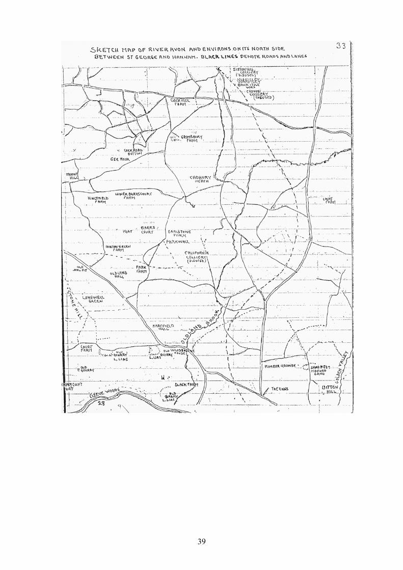
Troopers Hill (formerly Trubody’s Hill) is the best remaining area of visible coal workings still to be seen in the region. Besides adits driven into the hillsides at various angles, tub mines of no great depths were used with a rope and a windlass on the surfaces of the higher ground. The horse-whin also appears to have been used to wind up the coal by walking the horse in a circle. I met a man who claimed that his grand-father worked the last of the Tub mines, situated on what is now the eastern end of Avon View Cemetery opposite Cossham Road, St George. This would be around the year 1800. One must remember that the area spoken of was on a part of the Kingswood Forest renowned as a mining region from 1284. (See Notes on Coal Mining by D. Vintner 1964). Crew’s Hole Colliery is often spoken of. It was situated at the bottom of Trooper’s Hill road at its junction with Crew’s Hole Road. The remains of the Engine House still stands by the road side. The coal seam was worked there as late as 1880 according to a friend’s grandfather. It is no doubt the seam once intensively worked, around, and beneath the adjoining Trooper’s Hill. It is probably the thickest coal seam of the area. I saw this seam where it outcrops at the surface on the northwest corner of Trooper’s Hill close to the playing field. Here the seam was about five feet in thickness. During 1950 a shaft was uncovered al nearby Dundridge Gardens while making the road it was 200 feet in depth.
Crew’s Hole Glass Works (6) Two stone built ‘Glass Cones’ stood near the river bank in Crew’s Hole Road at the bottom of Lamb Hill. During 1960 when the main sewer was replaced they were destroyed. They cut through part of the old waste tip. The broken glass revealed looked like a heavy type of bottle glass. Much of it was a turquoise colour.

28
I took some samples to the City museum. The works were not used in my lifetime, but I heard my grandfather talk of glass making.
Bristol Fire Clay Co. Crew’s Hole (7) The Bristol Fire Clay Company obtained the clay by driving an adit at their Works near the bottom of Strawberry Lane, Crews Hole Road. They had a further adit or ‘Level’ near the South west corner of Trooper’s Hill, about 60 feet above Crew’s Hole Road. They made Furnace lining bricks, Terra Cotta facings, ornamental work and many other kinds of building and pottery work. Much of the facing work can be seen on buildings of the St George area and elsewhere. The kilns were situated near the river bank. The firm ceased work in 1914. My father and three of my uncles worked there. Crew’s Hole Chemical Company (Stone and Tinson’s) (8)
Also by Crew’s Hole Road and below Trooper’s Hill was ‘The Crew’s Hole Chemical Company’. Here my Uncle Bill worked. (1908) I don’t know what chemicals they made there. To carry away the smoke and fumes, they had a long flue cut into the surface of Trooper’s Hill, right up to a chimney stack at the top. The flue was about five feet deep and six feet across. It was covered with half-round steel plates, which could be removed to recover the soot. The stack is still standing on Trooper’s Hill (1986). These works were later taken into the Westward extension of William Butler’s Tar Distillery.

29
Note: The name Stone & Webber mentioned in the report on the Netham Works must be the above place.
Conham Chemical Company (9)
The reference to this place interests me because I think that it must have stood near the river bank, in Conham Road at the beginning of the Horseshoe bend, and near the lower end of Conham Vale. There was a ruined of works there when I was a boy and I always wondered what they made there. The ruin in now gone and the place has become the Picnic area of the Conham Leisure Park.
Ancient Copper works adjoining Conham Hall (now demolished)
(10) Near to Conham Ferry, on the left side of the lane approaching it, their was an extensive ruin, of which little now remains. Copper smelting was obviously carried on here. A strong quay wall and an arched over passage points to its river transport connection. Copper coated furnace lining bricks have been found (one was given to the City Museum). A block of ‘Black Jack’ furnace slag with the moulded in date 1729 was to be seen until recently on a cottage near the river bank in Conham Road. I have never found any Copper ore at the works, and it occurred to me that Brass may have been made here to supply the brass industry. Note: The above works must be the place referred to in the British Association report for 1875 as follows: “Brass was first made at Baptist Mills. The works were later removed to Hanham and Keynsham”. Note (T.R.F) Brass Wire was still being made at Avon Mills, Keynsham until (about) 1930.

30
Former Zinc Smelter at Hanham (11) This former works was situated on the valley side of Memorial Road Hanham. The incline tram road taking coal from Hanham Colliery down to the river barges cut through the abandoned works. During 1910 there was sufficient of the works remaining to show, what was evidently a Clock Tower, such as the one remaining at the site of a former Zinc Smelter at Warmley. This was soon obliterated by the tipping of waste from Hanham Colliery. The remainder of the works showed a line of fire-places about eight in number which were destroyed a few years later. No trace now remains except a small mass of furnace slag. From this I recovered some pieces of Calamine (Smithsonite) which I took to the City Museum. This was the kind of ore mined near Priddy in the western Mendips, toward the close of the 1?th century. It seems probable that it was taken to the previous locality near Conham ferry to make the Brass there. Note: copied from Braine’s History of Kingswood Forest relating to the above account – Hanham Hall in 1665 was bought by John Emmerson, Manager of Tower Works Warmley, he was the first to make Zinc from Calamine. He also had works at Hanham. (note by T.R.F.) It seems that the Zinc Smelter above is the one referred to by Braine.
Hanham Colliery (12) This Colliery was on the west side of Memorial Road Hanham. The date of sinking the shaft is not known to me, but it is written that there was no sign of it in 1875. A rich seam called “The Great vein” was worked. It seems possible that it was the same seam as the one occurring at Crew’s Hole. Hanham Colliery closed in 1926. Bristish Association Report for 1875.

31
The Powder House near Riverside Hanham (13)
This was a former building of considerable size situated near the river bank. As large quantities of Gun Powder was used for quarry blasting, I have often wondered whether it was brought by boat and stored here. It seems possible that it was manufactured here.
A Building of Unknown use at Riverside Hanham (14) A further building a short way upstream from the ‘Powder House’ stands in an orchard near the river bank. It shows five small fireplaces as though it was a drying kiln. The low fields nearby were called ‘The Withy Beds’ when I was a boy.
Hanham Mills (15) I know very little about this prominent place with its docks and weir. During my life-time the Mill buildings have gradually disappeared. However, Braine states in his ‘History of Kingswood Forest’ that the mill was the source of supply for the first Bristol Water Company. He states ‘The water was raised by Wheel Engine and that it flowed through hollow elm-pipes to a reservoir near Lawford’s Gate. He states that later the works were sold and turned into a Corn Mill’. Prehistoric Stone Implements found on the Brislington
side of the river near riverside Hanham (16) Stone implements (hand axes) of the Acheulean Culture of the Palaeolithic Period, have been found among surface river gravel of chert and flint. The gravel lies on the flat surfaces of the fields immediately above the railway line at Foxes Wood. The height is about 150 feet above the river, near the top of the cliff like south bank. These artifacts have obviously been carried there by the river when it flowed at this level. Prehistoric stone implements found at St Anne’s Estate
(17) Two hand axes of flint were found by myself, on the surface among river gravel during 1928.

32
These were referred to the Moustierian Culture of the Palaeolithic Period. The height of these finds was approximately 100 feet above the R. Avon. {Both of these localities together with the finds made are recorded in the University Spelaeological Proceedings for 1928 and 1956}.
Pennant Grit at Conham and Hanham (a) Quarrying The Pennant Grit, the rock which forms the steep edge of the valley between Crew’s Hole and Hanham Mills. It was formerly quarried along the entire stretch, both in large quarries near the river bank and in smaller quarries near the top of the valley sides. The larger quarries at Crew’s Hole and Conham have almost been obliterated by the tipping of household and industrial waste, but the rock is still well exposed in smaller quarries along the hill sides. Before the 1914 outbreak of war a flourishing river traffic in the stone was carried on between the quarries and Bristol. After the end of the war there was only occasional working of the stone in one or two re-opened quarries, and there was a complete cessation of barge traffic from the quarries. The rock is variable grit-stone, (a coarse variety of sandstone). The less variable type with constant grain size could be dressed or sawn as desired. The coarser varieties were used to build houses and walls, as will be seen on a visit to the district. Every construction seemed to have used Pennant stone. There were footpath stiles, gateposts, flag stones and cobbles for paving. Even tomb stones were made of it, but these latter were not good because the dressed stone often exfoliated or flaked off in continual weathering. Pennant was formerly worked underground near the southern end of Castle Farm road Hanham Green, in an area, once popular, known as “The Four Caves”. Here a bed of pennant of

33
good grain, and about 12 feet in thickness, was followed down for 100 feet below the surface, and worked out into great cavities. I once met a man, who had worked there around the year 1880. I used to watch the workmen dressing the stone in a large open shed at “Abel Brutons Pennant Stoneworks”, in a quarry at the eastern end of Crew’s Hole Road.
Colouration and minerals of pennant (b) Pennant is usually grey in colour, but faint shades blue or green can be seen especially when the stone is wet. Red and brown colouration is often seen especially in the shallower quarries near the surface. This is apparently due to staining by Iron oxide which has probably penetrated downward from the red Triassic rocks which once overlay the region. Apart from narrow veins of iron oxide – usually in the harder form called Gothite there is little mineralization to be found. Sometimes Gothite is coated by minute crystals of Barite. I have not noticed any quartz crystals and calcite is seldom found. …pebbles, usually of claystone are found as inclusions. These are almost certainly from contemporaneous reworked deposits. …… fossil wood fragments … (Gothite’s are often found) The rock generally is said to contain up to 5% of Calcium Carbonate.
Conditions of deposition of the Pennant Grit The Pennant seems to be deltaic in origin. The detritus having been transported by a river – or rivers into a subsidiary area. Grits silts and muds were carried along and deposited. Often swamp conditions prevailed, and pauses in sedimentation allowed plant growth which gave rise to - usually thick coal seams, with their under-clay. One can detect in several quarries the sequence of events. Firstly the Gritstone overlain by siltstone flags, sometimes ripple marked, - and next the underclay followed by grit again. Often a reversak if conditions sets in, and siltstone is lain followed by grit again. Lens shaped masses of shale varying from a few feet to many that have been trapped in hollows between the grits often occur. In the shale

34
one may find leaves and plant stems at several places. The best locality is the mudstone at the base of the quarry face on the west side in Buckley (Bickley?) Wood. The plants here and elsewhere are usually the seed from Neuropteris and the Equisetum Calamites. In the coarse grits and consolidated fine gravelly deposits, one may find evidence of masses of tree trunks which have been borne into the delta. The recognisable fossil tree trunks are usually of the well known coal measure plants Siyillana and Lepidodendron, but there are other lesser known genera. Fossil wood is also found, often of a worn, driftwood appearance. I once found a sterhergia (frith cast) enclosed in woody tissue, with the external bark now converted into a layer of coal. It was almost three feet long. Sometimes pieces of fossilized wood, and clay-stone pellets were found inside the gritstone by the stone-dressers. The workers were very annoyed when this happened. Animal remains must be rare in Pennant. Gritstone is not a good preserver. Only once did I find any, and these were just a few badly preserved fresh water shells, fish scales and the minute shells of Ostracods. These finds were made in a layer of shale ? inch in thickness at the foot of the vertical face of the massive gritstone exposed at the eastern side in Buckly Wood. (These were given to Professor Trueman in 1930). Contemporaneous erosion and re-deposition of the sediments is very noticeable. Layers of coal grit, coal fragments and coal pebbles are found The old quarry on Troopers Hill is a good place to study this. There is also siltstone, claystone, and other inclusions seen in the pennant. Often the coarse gritstone is strongly cross bedded. Where has all the deposits of the Pennant Grit come from? They are stated to be more than 2,000 feet in thickness. They have been said to be polygenetic in origin. According to the material studied from boreholes at Westerleigh and Somerset, they are said to be of many types of mainly igneous and metamorphic rocks from as far as I am aware, unknown areas.
35
(The Pennant grits exposed along the Avon Valley forms the southern limit of the Kingswood Anticline. The angle of dip is to the south and south east usually at an angle of 0 - 35°. (Authors – L.R.Moore and Prof. A.E. Trueman).
NETHAM WORKS, 1939 – 1947
T. R. FRY (1) Sulphuric Acid Plant The main production when I worked there (1939) was Sulphuric Acid. This was made in 100ft high wooden chambers lined with lead, situated at the N.E. end of the works. The process was to burn sulphur containing substances on small furnaces at the base of the chambers. As the gases rose they were trapped by water descending from a sprinkler system, and thus converted into sulphuric acid. The substances used were mainly spent oxide (Bog iron ore) (A waste product obtained from domestic Gas works, where it had been used in a purification process). Pure sulphur crystals were sometimes also used. The residue after extraction, a red earthy substance, was thrown on the works waste tip, which was known as the ‘Brilla’. (2) Hydrochloric Acid Plant This plant was situated at the southern end of the works near the eastern side of Netham road. The salt was brought to the works by barge, to the wharf. It was then lifted about 20 feet, by crane onto trams. The loaded trams were pushed by hand along a short tramway to the end where the salt was tipped into the master furnace situated at the roadside. After being calcined at high temperatures the resultant gases were conveyed to a fifty foot high lead lined wooden chamber to make hydrochloric acid. The salt residues called Saltcake, were pushed by tram to the salt-cake shed, at the northern [end] of the works where it was stored until it was required for re-export.

36
Note: The salt cake shed was burned down in 1945, leaving hundreds of tons of salt cake exposed to the elements. This soon became rock-hard and could not be moved. It was, I presume, removed after the Bristol Corporation took over the area to make Netham Playing Field – T.R.F. (3) Soda Making Department Also on the southern end of the works, on the east side of Netham road, was the Soda cystal making department. This was the most flourishing part of Netham in 1939, and thereafter until the plant closed down in 1945. The basic soda liquor was prepared in a large vat and then pumped into the Soda room. Here it was [put] into half round iron basins called Coons (Cones). When the crystallizing process was completed the crystals were hacked out, and then crushed and bagged for sale. (4) Sal-Ammoniac Plant This plant lay close to the middle part of Netham road on the west side where part of the playing field now lies. Production ceased when the supply of ammonia liquor brought from the Domestic Gas Works ceased (?date 1945). (5) Other Plant (Disused) Other large buildings lay on the eastern side. These were mainly called the Copper ore department. Production ceased here before I went to Netham. I believe that large quantities of acid were once made there. There was also the ‘Blue’ section where domestic washing blue was made. The copper ore was brought to the wharf by barge and the residues after burning were stored in the three stone chambers built into the wall near the wharf to be taken elsewhere. (These chambers are still visible T.R.F.). Note: re Iron Pyrites T.R.F.

37
I have never heard of Iron Pyrites being used at Netham but it appears that the ore used was Copper Pyrites (Copper Sulphide) - pieces could be picked [up] at the works. Of course Iron Pyrites may have been used, I never heard of it. Netham Mortar, made from lime and ashes was used extensively in the district around the turn of the century. It was noted for its high quality and hardness. I have heard talk about this. I would think they would have used all the surplus lime in this way. The Brilla (tip) contained all the miscellaneous waste and rubbish from the works. Is your statement of lime being sold from the tip after the works closed being confused with the huge store of salt-cake which remained there after closure? Coal. There was formerly much coal mined locally. A shaft top was to be seen in the works near the bottom end of Netham road (east side), further shafts were located where the playing field lies. There was also ‘Pilemarsh Colliery’ nearby, but I don’t know any details of this. (T.R.F.) Coal from Crew’s Hole Colliery situated at the lower end of Troopers Hill road may also have been used.

38
39