Embed Size (px)
Citation preview

STATE OF MAINE
JOHN E. BALDACCI
GOVERNOR
DEPARTMENT OF CONSERVATION LAND USE REGULATION COMMISSION
18 ELKINS LANE – HARLOW BUILDING 22 STATE HOUSE STATION AUGUSTA, ME 04333-0022
PATRICK McGOWAN COMMISSIONER
Memorandum May 20, 2008
TO: Commissioners FROM: Agnieszka Pinette, Senior Planner, Land Use Regulation Commission SUBJECT: Materials for the Commission’s May 27-28 deliberative sessions in the matter of Zoning Petition ZP
707 – Plum Creek’s proposed Concept Plan for the Moosehead Lake region
Please find enclosed with this memorandum the following materials for the Commission’s May 27-28 deliberations in the matter of Zoning Petition ZP 707 (Plum Creek’s proposed Concept Plan for the Moosehead Lake region): 1. Agenda for the Commission’s May 27-28 Deliberative Sessions (as adopted by the Commission at its May 7,
2008 meeting); 2. Staff and Consultant Recommendations for the Land Use Regulation Commission’s May 27-28 Deliberative
Sessions. The enclosed recommendations address what staff/consultants have identified as the core issues presented by Plum Creek’s Concept Plan proposal, based on the written testimony, the hearings, the party briefs and independent staff/consultant analysis of the record. During the deliberative sessions, staff/consultants will generally be seeking guidance from the Commission on what amendments to the proposed Concept Plan, if any, the Commission determines are necessary to satisfy governing review criteria and will specifically be seeking the Commission’s reactions to each of the recommendations. In order to establish a logical and efficient decision-making hierarchy, the recommendations do not attempt to address the numerous detailed sub-issues associated with each core issue (e.g., specific language recommendations to the easement documents or the proposed Chapter 10 addendum of permitted uses and land use standards). We recommend addressing those sub-issues later in the process should the Commission direct the preparation of specific Concept Plan amendment language.
Land Use Regulation Commission PHONE: (207) 287-2631 Catherine M. Carroll, Director TTY: (207) 287-2213 FAX: (207) 287-7439

Memorandum to Commission: Zoning Petition ZP 707 May 20, 2008
Page 2 of 2
Given the constraints of time and space, each individual recommendation generally does not include a detailed statement of supporting rationale. We appreciate that Commission members will likely be interested (to a greater or lesser degree) in understanding the basis for these recommendations, and will welcome such questions during the deliberations. The recommendations, taken as a whole, represent our best professional judgment about how the proposed Concept Plan might be amended to satisfy governing review criteria. However, the recommendations are not intended to bind the Commission in any way or limit its discretion to consider or develop alternative approaches to addressing any of the issues presented. We are prepared to assist the Commission both to understand these recommendations, and also to consider alternatives of interest to the Commission. Enclosures: Agenda for the Commission’s May 27-28 Deliberative Sessions
Staff and Consultant Recommendations for the Land Use Regulation Commission’s May 27-28 Deliberative Sessions XC: Zoning Petition ZP 707 File

DEPARTMENT OF CONSERVATION
LAND USE REGULATION COMMISSION 18 ELKINS LANE – HARLOW BUILDING
22 STATE HOUSE STATION AUGUSTA, ME 04333-0022
PATRICK McGOWAN
STATE OF MAINE
JOHN E. BALDACCI GOVERNOR COMMISSIONER
AGENDA
FOR THE COMMISSION’S MAY 27-28, 2008 DELIBERATIVE SESSIONS IN THE MATTER OF ZONING PETITION ZP 707
PLUM CREEK MAINE TIMBERLANDS, L.L.C. AND PLUM CREEK LAND COMPANY
(Adopted by the Land Use Regulation Commission on May 7, 2008)
Land Use Regulation Commission PHONE: (207) 287-2631 Catherine M. Carroll, Director TTY: (207) 287-2213 FAX: (207) 287-7439

Agenda for the Commission’s May 27-28 Deliberative Sessions Zoning Petition ZP 707
Page 2 of 4
1. PROPOSED DEVELOPMENT AREAS Will the review criteria for concept plans be satisfied if the Commission accepts Plum Creek’s proposal to rezone each of the following areas for development, considering, among other things, their locations, sizes, resources, character, and existing uses:
A. Beaver Cove B. Upper Wilson Pond C. Lily Bay
Residential area Resort-related area Lily Bay Mountain “low-impact” area
D. Big Moose Mountain Big Moose Mountain Moosehead Lake -- Deep Cove Burnham Pond Indian Pond “low-impact” area
E. Moose Bay Village F. D-CI Commercial Zone G. Route 6/15 Corridor H. Rockwood/Blue Ridge I. Brassua Lake
Brassua Lake south peninsula Brassua Lake northeast shore
J. Long Pond Northwest shore Northeast shore Southeast shore Southwest shore
2. PROPOSED LAND USE ZONES AND STANDARDS
A. Are Plum Creek’s proposed development zones consistent with the review criteria for concept plans? Are the lists of uses (including uses allowed without a permit, uses allowed without a permit subject to standards, uses requiring a permit, or special exception uses) within (1) each development area, and (2) the lands proposed for conservation, consistent with the review criteria for concept plans?
B. Is Plum Creek’s proposal to freeze the boundaries of protection zones located within development areas for 30 years consistent with the review criteria for concept plans?
C. Is Plum Creek’s proposal to freeze certain land use standards for the 30-year term of the concept plan in return for a grant of permanent conservation lands consistent with the review criteria for concept plans?
D. Is Plum Creek’s proposal to modify, add or delete portions of the Commission’s otherwise applicable regulations (e.g., scenic impact standards, subdivision layout and design standards) consistent with the review criteria for concept plans?

Agenda for the Commission’s May 27-28 Deliberative Sessions Zoning Petition ZP 707
Page 3 of 4
E. Is Plum Creek’s proposal to include certain land use standards in homeowner associations’ declarations of covenants, conditions and restrictions consistent with the review criteria for concept plans?
F. Are any additional or modified review processes and/or land use standards necessary for Plum Creek’s proposal to satisfy the review criteria for concept plans?
3. TOTAL NUMBER OF UNITS WITHIN THE 30-YEAR TERM OF THE CONCEPT PLAN
Is Plum Creek’s proposal to develop up to 975 residential dwelling units, 1050 resort accommodation units, affordable housing, employee housing, caretaker/manager housing, and other non-residential development consistent with the review criteria for concept plans, considering both area-specific and cumulative impacts?
4. “BALANCE” CONSERVATION EASEMENT
A. Do the (1) location and (2) amount of land included in the proposed “Balance” conservation easement satisfy the review criteria for concept plans, including for: Waivers of adjacency (comparable conservation); Mitigation to prevent undue adverse impacts to existing uses and resources (e.g., recreational
resources, wildlife resources); and Publicly beneficial balance?
B. Do the provisions contained in Plum Creek’s proposed “Balance” conservation easement satisfy the review criteria for concept plans? These provisions include, inter alia, those addressing: The type, intensity and location of permitted structures and uses; Forest practices standards; Subdivision; Enforcement; and Entities proposed as easement holder and third party.
C. Are any additional provisions not contained in Plum Creek’s proposed “Balance” conservation easement required to satisfy the review criteria for concept plans (e.g., stewardship/monitoring fund)?
D. Does the proposed timing for execution of Plum Creek’s proposed “Balance” conservation easement satisfy the review criteria for concept plans?
5. CONSERVATION FRAMEWORK
Are any components of the Conservation Framework (i.e., the Moosehead Legacy conservation easement, fee sale of the Roaches Tract, and fee sale of Number 5 Bog) required to satisfy the review criteria for concept plans? If one or more components, in whole or in part, is required: A. Has Plum Creek proposed the necessary, enforceable provisions and terms to satisfy the review criteria for
concept plans? B. Does the proposed timing for execution of these components satisfy the review criteria for concept plans?

Agenda for the Commission’s May 27-28 Deliberative Sessions Zoning Petition ZP 707
Page 4 of 4
6. ADDITIONAL CONCEPT PLAN ELEMENTS A. Do the additional plan elements proposed by Plum Creek, in combination with the proposed development
and other offset provisions, satisfy the review criteria for concept plans? These additional plan elements are: Peak-to-Peak trail easement; Hut-to-Hut trail easement; ITS trail easement; Vehicular road access easements; Affordable housing; and Community stewardship fund.
B. Do the conditions imposed by the Maine Department of Transportation’s Traffic Movement Permit satisfy the review criteria for concept plans as they relate to traffic congestion and safety?
C. Is Plum Creek’s proposal to permanently conserve any remaining land in proposed development areas on which development has not occurred by the end of 30 years (as part of the so-called “Balance Easement) consistent with the review criteria for concept plans?
7. CONCEPT PLAN IMPLEMENTATION MECHANISMS
A. Are Plum Creek’s proposed concept plan provisions governing amendment consistent with applicable review criteria?
B. Are Plum Creek’s proposed concept plan provisions governing implementation of the plan by LURC, including, inter alia, administration, enforcement and the proposed role for the Homeowner Associations’ Covenants, Conditions and Restrictions in plan implementation consistent with applicable review criteria?
C. Are Plum Creek’s proposed planning and review processes at development application stages consistent with applicable review criteria?

STATE OF MAINE
JOHN E. BALDACCI
GOVERNOR
DEPARTMENT OF CONSERVATION LAND USE REGULATION COMMISSION
18 ELKINS LANE – HARLOW BUILDING 22 STATE HOUSE STATION AUGUSTA, ME 04333-0022
PATRICK McGOWAN COMMISSIONER
ZONING PETITION ZP 707 PLUM CREEK MAINE TIMBERLANDS, L.L.C. AND PLUM CREEK LAND COMPANY
STAFF AND CONSULTANT RECOMMENDATIONS FOR THE LAND USE REGULATION COMMISSION’S
MAY 27-28 DELIBERATIVE SESSIONS
May 20, 2008
Land Use Regulation Commission PHONE: (207) 287-2631 Catherine M. Carroll, Director TTY: (207) 287-2213 FAX: (207) 287-7439

TABLE OF CONTENTS
PROPOSED DEVELOPMENT AREAS ……………………………………………………………………… 1 Beaver Cove
Upper Wilson Pond
Lily Bay
Big Moose Mountain
Moose Bay
D-CI Commercial Zone
Route 6/15 Corridor
Rockwood/Blue Ridge
Brassua Lake
Long Pond
Total Number of Units
PROPOSED LAND USE ZONES AND STANDARDS …………………………………………………… 46 Land Use Zoning (Permitted Uses)
Planning and Design Components within Development Areas
Scenic, Lighting and Noise Standards
Maine Department of Transportation Traffic Movement Permit
OFFSET CONSERVATION: BALANCE CONSERVATION EASEMENT ……………………………… 72
CONSERVATION FRAMEWORK …………………………………………………………………………… 93 Moosehead Legacy Easement
Roaches Property
Bog Properties

ADDITIONAL CONCEPT PLAN ELEMENTS ……………………………………………………………… 110 Snowmobile Trail Easements
Peak-to-Peak Trail Easement
Hut-to-Hut Trail Easement
Vehicular Road Access Easements
Community Stewardship Fund
Land Donations to BPL
Affordable Housing
CONCEPT PLAN IMPLEMENTATION MECHANISMS …………………………………………………… 118 Concept Plan Amendment
Covenants, Conditions and Restrictions (CCRs) Applicable to Subdivisions
SECOND TIER ISSUES ……………………………………………………………………………………… 126

1
PROPOSED DEVELOPMENT AREAS

BEAVER COVE DEVELOPMENT AREA
The following recommendations address Plum Creek’s proposal to rezone approximately 117 acres for development in the Town of Beaver Cove to accommodate approximately 32 residential dwelling units and municipal facilities adjacent to the Beaver Cove town office. Pertinent details of Plum Creek’s proposal for this development area are set forth in the table that follows.
2

3
RECOMMENDATIONS FOR THE BEAVER COVE DEVELOPMENT AREA
Concept Plan Proposal Recommendations
Numbers and types of units
1. Residential units Uncapped (32 planned).
2. Resort accommodation units None proposed.
3. Caretaker/manager housing Uncapped.
4. Affordable housing Uncapped.
5. Employee housing None proposed.
No recommended changes.
Ability to transfer in additional residential units, up to 975 residential unit cap
Yes (potential receiving area). No recommended changes.
Approx. size and configuration of development area(s)
Total: 127 acres.
117 acres (D-RS3M zone).
10 acres (two M-GNM zones).
No recommended changes to size or configuration of development areas.
Land use zoning D-RS3M (Residential Recreation Development) zone: Accommodates predominantly residential subdivisions comprised only of single family dwellings.
M-GNM (General Management) zone: Accommodates municipal buildings, facilities and structures in this development area.
Replace D-RS3M and M-GNM zones with new D-MH-RS1 zone to allow primarily residential development (both single and multi-family, including affordable housing) as well as public/civic uses and facilities, home occupations and other uses compatible with residential development, and to prohibit commercial or industrial uses.1
1 See recommendations, Land Use Zoning (Permitted Uses).

4
RECOMMENDATIONS FOR THE BEAVER COVE DEVELOPMENT AREA (CONTINUED) Concept Plan Proposal Recommendations
Development review process LURC subdivision/development review, subject to statutory criteria, regulatory criteria and Concept Plan addendum to Chapter 10.
LURC subdivision/development review, subject to statutory and regulatory criteria and Concept Plan addendum to Chapter 10 -- as modified by pertinent recommendations.2
Reservation of excess lands Not proposed. No recommended changes.
Disposition of undeveloped land after 30-year term
Balance easement. Subject to Commission zoning at end of 30-year term.3
2 For example, see recommendations, Land Use Zoning (Permitted Uses); Planning and Design Components within
Development Areas; and Scenic, Lighting and Noise Standards. 3 See recommendations, Planning and Design Components within Development Areas.

UPPER WILSON POND DEVELOPMENT AREA
The following recommendations address Plum Creek’s proposal to rezone approximately 184 acres for development on Upper Wilson Pond to accommodate up to 32 residential dwelling units. Pertinent details of Plum Creek’s proposal for this development area are set forth in the table that follows.
5

6
RECOMMENDATIONS FOR THE UPPER WILSON POND DEVELOPMENT AREA (CONTINUED) Concept Plan Proposal Recommendations
Numbers and types of units
1. Residential units Capped (32 units). Capped at 32 residential units.4
2. Resort accommodation units None proposed. No recommended changes.
3. Caretaker/manager housing Uncapped. No recommended changes.
4. Affordable housing None proposed. Permitted use, subject to 32 residential unit cap.
5. Employee housing None proposed. No recommended changes.
Ability to transfer in additional residential units, up to 975
No. No recommended changes.
Approx. size and configuration of development area(s)
184 acres, including 4,561 feet of shorefront on Upper Wilson Pond.
No recommended changes to size or configuration of development area.
4 The number of units within this development area would be permanently capped at 32 total units, with actual number
and location of units based on subdivision review and approval. Permanency of the cap would be accomplished not through donation of unused lands to the ‘Balance’ conservation easement following build-out of 32 units, as currently proposed by Plum Creek, but instead through restrictive covenants on land within the zone extinguishing additional development rights beyond 32 units. These restrictive covenants would be placed on the land at the time of Concept Plan approval. Thus, these restrictive covenants would permanently preclude additional development of residential units (including vertical expansion of such units) but not add acreage to the ‘Balance’ conservation easement.

7
RECOMMENDATIONS FOR THE UPPER WILSON POND DEVELOPMENT AREA (CONTINUED) Concept Plan Proposal Recommendations
Land use zoning D-RS3M (Residential Recreation Development) zone: Accommodates predominantly residential subdivisions comprised only of single family dwellings.
Replace D-RS3M zone with new D-MH-RS1 zone to allow primarily residential development (both single and multi-family, including affordable housing) as well as public/civic uses and facilities, home occupations and other uses compatible with residential development, and to prohibit commercial or industrial uses.5
Development review process LURC subdivision/development review, subject to statutory criteria, regulatory criteria and Concept Plan addendum to Chapter 10.
LURC subdivision/development review, subject to statutory and regulatory criteria and Concept Plan addendum to Chapter 10 -- as modified by pertinent recommendations.6
Reservation of excess lands Not proposed. No recommended changes.
Disposition of undeveloped land after 30-year term
Balance easement. Restrictive covenant (see footnote 4, above).
Limitations on shoreland structures
Not proposed. Limit shoreland structures (including temporary docks, moorings, and boat launches) to one common water access point that would serve the entire development area.
Management Class 4 lake requirements
Eliminate existing LURC Management Class 4 lake subdivision review requirements regarding (1) indication of landowner’s future plans for undeveloped shores and (2) Section 10.25,R clustering.
No recommended changes.
5 See recommendations, Land Use Zoning (Permitted Uses). 6 For example, see recommendations regarding Land Use Zoning (Permitted Uses); Planning and Design Components
within Development Areas; and Scenic, Lighting and Noise Standards.
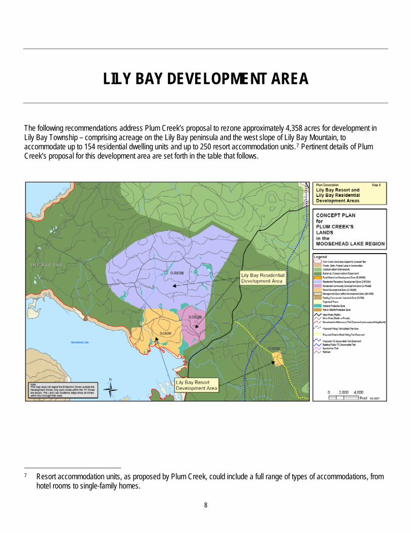
LILY BAY DEVELOPMENT AREA
The following recommendations address Plum Creek’s proposal to rezone approximately 4,358 acres for development in Lily Bay Township – comprising acreage on the Lily Bay peninsula and the west slope of Lily Bay Mountain, to accommodate up to 154 residential dwelling units and up to 250 resort accommodation units.7 Pertinent details of Plum Creek’s proposal for this development area are set forth in the table that follows.
7 Resort accommodation units, as proposed by Plum Creek, could include a full range of types of accommodations, from
hotel rooms to single-family homes.
8

9
RECOMMENDATIONS FOR THE LILY BAY DEVELOPMENT AREA Concept Plan Proposal Recommendations
Numbers and types of units
1. Residential units Capped (154 units).
2. Resort accommodation units Capped (250 units).
Capped at any combination of 404 residential units or resort accommodation units; low impact resort accommodations in 52-acre zone on Lily Bay Mountain capped at 10,000 square feet.8
3. Caretaker/manager housing Uncapped. No recommended changes.
4. Affordable housing None proposed. Permitted use, subject to 404 unit cap.
5. Employee housing Uncapped. No recommended changes.
Ability to transfer in additional residential units, up to 975
No. No recommended changes.
8 The number of units within this development area would be permanently capped at 404 total residential and/or resort
accommodation units, with actual number and location of units based on subdivision/development review and approval. The total size of low impact resort accommodations on Lily Bay Mountain would be permanently capped at 10,000 square feet. Permanency of the cap would be accomplished not through donation of unused lands to the ‘Balance’ conservation easement following build-out, as currently proposed by Plum Creek, but instead through restrictive covenants on land within the zone extinguishing additional development rights beyond 404 units and, on Lily Bay Mountain, beyond 10,000 square feet. These restrictive covenants would be placed on the land at the time of Concept Plan approval. Thus, these restrictive covenants would permanently preclude additional development of residential and resort accommodation units (including vertical expansion of such units) but not add acreage to the ‘Balance’ conservation easement.

10
RECOMMENDATIONS FOR THE LILY BAY DEVELOPMENT AREA (CONTINUED) Concept Plan Proposal Recommendations
Approx. size and configuration of development area(s)
Total: 4,358 acres, including 9,900 feet of shorefront on Moosehead Lake.
357 acres (D-RS2M zone – Lily Bay southeast).
3,224 acres (D-RS3M zone – Lily Bay highlands).
725 acres (D-GN2M zone west of Lily Bay Road).
52 acres (D-GN2M zone east of Lily Bay Road).
Remove from the D-RS3M (Lily Bay highlands) zone approximately 2,997 of the 3,224 acres proposed; add this acreage to Balance conservation easement acreage.9
Remove from the D-GN2M zone (west of Lily Bay Road) a waterfowl and wading bird habitat and its associated 250-foot buffer; add this acreage to Balance conservation easement acreage.10
No recommended changes to the size and configuration of the D-RS2M (Lily Bay southeast) zone.11
No recommended changes to the size and configuration of the 52-acre primitive resort development zone east of Lily Bay Road.
9 The approximately 227 acres of the D-RS3M zone that would remain as part of the recommended Lily Bay development
area generally are located at or below the 1240+/- foot contour and a logging road near that contour, immediately north of the lower proposed development zones, but not including an area of wetlands and wet soils located just north of the D-RS2M zone.
10 IFW/MNAP’s August 31, 2007 comments also include a recommendation to remove from the proposed Lily Bay development area a buffer along both sides of Burgess Brook. Staff/consultants recommend instead adopting a “no disturbance buffer” land use standard that would apply within 250 feet of either side of Burgess Brook. This would avoid fragmenting the development area while providing a comparable level of protection for the identified natural resource values in this area.
11 Staff/consultants note that a mapped sand and gravel aquifer exists in the southeast corner of this zone where land uses should be restricted, as recommended later in this table (see recommendation, Land Use Zoning, below).

11
RECOMMENDATIONS FOR THE LILY BAY DEVELOPMENT AREA (CONTINUED) Concept Plan Proposal Recommendations
Land use zoning D-RS2M (Community Residential Development) zone: Accommodates predominantly residential subdivisions and a range of housing types, including multi-family dwellings, as well as community facilities and major home occupations.
D-RS3M (Residential Recreation Development) zone: Accommodates predominantly residential subdivisions comprised only of single family dwellings.
D-GN2M (Resort Development) zone: Accommodates a broad mix of recreational, commercial and residential uses, and allows larger scale development associated with resort development.12 Areas described as suitable only for “low impact” development would have exact same zoning as remainder of resort development zone.13
Replace 52-acre D-GN2M zone with a new Primitive Resort Development (D-MH-PR) zone that would (1) restrict permitted uses to primitive resort uses and facilities modeled on the intensity and type characterized by LURC’s current definition for commercial sporting camps and (2) prohibit subdivision of land.14
Replace remaining recommended development area with a residential/ resort-optional development (D-MH-RS2) zone, that would allow, but not require, resort-related commercial and residential development (i.e. residential and/or resort accommodation units would be allowed without a resort core).15
If a resort core is developed, then employee housing would be required to satisfy employee housing needs (if any) created by short-term units.
Restrict development over the mapped sand and gravel aquifer in this zone to facilities and uses identified as acceptable in consultation with the Maine Geological Survey.
12 Resort development must consist of a resort core with at least 15 short-term visitor accommodations, hospitality
amenities, recreational uses and facilities, resort accommodation units, and open space; resort accommodation units are defined to include a full range of accommodations, from hotel units to single-family homes. In addition to these required resort core components, the zone permits a detailed list of other uses (e.g., forest management; public safety facilities; other public and institutional uses; a range of commercial uses; beach, shore, and water access facilities; temporary docks; public trailered ramps, etc.).
13 Plum Creek proposes to define “low impact resort accommodations” as consisting of a group of facilities functioning primarily as a destination for persons in pursuit of traditional primitive outdoor recreation that have a total floor area of no greater than 10,000 square feet for all principal buildings associated with the facility, with no single building having a floor area of greater than 2,000 square feet.
14 See recommendations, Land Use Zoning (Permitted Uses). 15 Ibid.
12
RECOMMENDATIONS FOR THE LILY BAY DEVELOPMENT AREA (CONTINUED) Concept Plan Proposal Recommendations
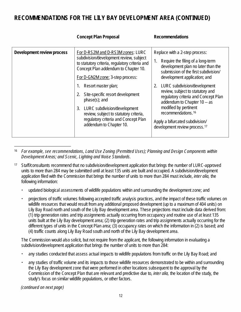
Development review process For D-RS2M and D-RS3M zones: LURC subdivision/development review, subject to statutory criteria, regulatory criteria and Concept Plan addendum to Chapter 10.
For D-GN2M zone: 3-step process:
1. Resort master plan;
2. Site-specific resort development phase(s); and
3. LURC subdivision/development review, subject to statutory criteria, regulatory criteria and Concept Plan addendum to Chapter 10.
Replace with a 2-step process:
1. Require the filing of a long-term development plan no later than the submission of the first subdivision/ development application; and
2. LURC subdivision/development review, subject to statutory and regulatory criteria and Concept Plan addendum to Chapter 10 -- as modified by pertinent recommendations.16
Apply a bifurcated subdivision/ development review process.17
16 For example, see recommendations, Land Use Zoning (Permitted Uses); Planning and Design Components within
Development Areas; and Scenic, Lighting and Noise Standards. 17 Staff/consultants recommend that no subdivision/development application that brings the number of LURC-approved
units to more than 284 may be submitted until at least 135 units are built and occupied. A subdivision/development application filed with the Commission that brings the number of units to more than 284 must include, inter alia, the following information:
updated biological assessments of wildlife populations within and surrounding the development zone; and
projections of traffic volumes following accepted traffic analysis practices, and the impact of these traffic volumes on wildlife resources that would result from any additional proposed development (up to a maximum of 404 units) on Lily Bay Road north and south of the Lily Bay development area. These projections must include data derived from: (1) trip generation rates and trip assignments actually occurring from occupancy and routine use of at least 135 units built at the Lily Bay development area; (2) trip generation rates and trip assignments actually occurring for the different types of units in the Concept Plan area; (3) occupancy rates on which the information in (2) is based; and (4) traffic counts along Lily Bay Road south and north of the Lily Bay development area.
The Commission would also solicit, but not require from the applicant, the following information in evaluating a subdivision/development application that brings the number of units to more than 284:
any studies conducted that assess actual impacts to wildlife populations from traffic on the Lily Bay Road; and
any studies of traffic volume and its impacts to those wildlife resources demonstrated to be within and surrounding the Lily Bay development zone that were performed in other locations subsequent to the approval by the Commission of the Concept Plan that are relevant and predictive due to, inter alia, the location of the study, the study’s focus on similar wildlife populations, or other factors.
(continued on next page)

13
RECOMMENDATIONS FOR THE LILY BAY DEVELOPMENT AREA (CONTINUED)
17 (continued)
The Commission would also solicit, but not require from the applicant, the following information in evaluating a subdivision/development application that brings the number of units to more than 284:
any studies conducted that assess actual impacts to wildlife populations from traffic on the Lily Bay Road; and
any studies of traffic volume and its impacts to those wildlife resources demonstrated to be within and surrounding the Lily Bay development zone that were performed in other locations subsequent to the approval by the Commission of the Concept Plan that are relevant and predictive due to, inter alia, the location of the study, the study’s focus on similar wildlife populations, or other factors.
The Commission would apply the criteria of Section 10.24 of the Commission’s Land Use Districts and Standards and other relevant statutory and regulatory criteria to the subdivision/development application, and base its review on these required studies, as well as any other relevant information produced by the applicant or interested persons. The application for this phase of subdivision/development review would be acted upon at the Commission, not staff, level.
NOTE: In recommending this bifurcated subdivision/development review process, staff/consultants are recognizing that much, although not all, of the evidence regarding impacts on wildlife resources was in the form of predictions (e.g., what would be the traffic counts north and south of the proposed Lily Bay development; what would be the reactions of, and impacts to, Canada lynx to increases in traffic on the Lily Bay Road, what would be the mitigating effect of large adjacent areas of conservation easements). While staff/consultants believe that the record is sufficient to support rezoning land on the Lily Bay peninsula sufficient to accommodate the proposed 404 units (provided that this rezoned land is properly located -- see recommendation regarding size and configuration of this development area, above), the Commission’s decision-making at the subdivision/development review stage would benefit from updated information regarding any impacts to wildlife resources in the Lily Bay development area that have occurred as a result of actual development within the Lily Bay peninsula, as well as the Concept Plan area, particularly should the Commission be presented with a subdivision/development application for more than 284 units -- the point at which the applicant’s traffic prediction methodology would project that AADT in the vicinity of the Lily Bay development area will reach 3,000 vehicles per day. Having at least 135 units – one-third of the proposed development -- in place for such studies will produce a reliable sample for the updated projections. This approach is consistent with Plum Creek’s repeated acknowledgment on the record that subdivision/development review represents an independent opportunity for the Commission to re-examine potential adverse impacts from development based upon a more detailed and specific factual record than is necessary or even possible at the rezoning stage (see, for example, Plum Creek’s Opening Brief, March. 7, 2008, pp 14-15: “The ‘no undue adverse impact’ standard is reiterated throughout the LURC statute, rules and the CLUP. It applies both to applications for rezoning, including a concept plan, and to applications for subdivision approval.” And “...the Commission expects more detailed information at the subdivision level so it can again consider the undue adverse impact analysis at that stage”). The Commission, at its discretion, could require a repeat of the studies for later phases if necessary.
14
RECOMMENDATIONS FOR THE LILY BAY DEVELOPMENT AREA (CONTINUED) Concept Plan Proposal Recommendations
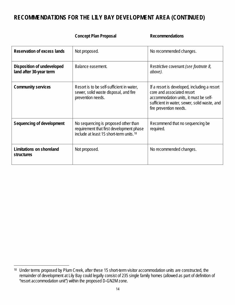
Reservation of excess lands Not proposed. No recommended changes.
Disposition of undeveloped land after 30-year term
Balance easement. Restrictive covenant (see footnote 8, above).
Community services Resort is to be self-sufficient in water, sewer, solid waste disposal, and fire prevention needs.
If a resort is developed, including a resort core and associated resort accommodation units, it must be self-sufficient in water, sewer, solid waste, and fire prevention needs.
Sequencing of development No sequencing is proposed other than requirement that first development phase include at least 15 short-term units.18
Recommend that no sequencing be required.
Limitations on shoreland structures
Not proposed. No recommended changes.
18 Under terms proposed by Plum Creek, after these 15 short-term visitor accommodation units are constructed, the
remainder of development at Lily Bay could legally consist of 235 single family homes (allowed as part of definition of “resort accommodation unit”) within the proposed D-GN2M zone.

BIG MOOSE MOUNTAIN DEVELOPMENT AREA
The following recommendations address Plum Creek’s proposal to rezone approximately 4,446 acres for development in Big Moose Township – comprising acreage on the northeast and northwest slopes of Big Moose Mountain, the north shore of Burnham Pond, the shore of Deep Cove on Moosehead Lake, and the shore of Indian Pond -- to accommodate up to 800 resort accommodation units,19 with the potential to relocate additional residential dwelling units from elsewhere in the Concept Plan to this development area. Pertinent details of Plum Creek’s proposal for this development area are set forth in the table that follows.
15
19 Resort accommodation units, as proposed by Plum Creek, could include a full range of types of accommodations, from hotel rooms to single-family homes.

16
RECOMMENDATIONS FOR THE BIG MOOSE MOUNTAIN DEVELOPMENT AREA (CONTINUED)
Concept Plan Proposal Recommendations
Numbers and types of units
1. Residential units None proposed.
2. Resort accommodation units Capped (800 units).
3. Caretaker/manager housing Uncapped.
4. Affordable housing Uncapped.
5. Employee housing Uncapped.
No recommended changes to numbers and types of units; low impact resort accommodations on Indian Pond capped at 10,000 square feet.20
Ability to transfer in additional residential units, up to 975
Yes (potential receiving area). No recommended changes.
20 The total size of low impact resort accommodations on Indian Pond would be permanently capped at 10,000 square
feet. Permanency of the cap would be accomplished not through donation of unused lands to the ‘Balance’ conservation easement following build-out, as currently proposed by Plum Creek, but instead through restrictive covenants on land within the zone extinguishing additional development rights 10,000 square feet. These restrictive covenants would be placed on the land at the time of Concept Plan approval. Thus, these restrictive covenants would permanently preclude additional development of residential and resort accommodation units (including vertical expansion of such units) but not add acreage to the ‘Balance’ conservation easement.

17
RECOMMENDATIONS FOR THE BIG MOOSE MOUNTAIN DEVELOPMENT AREA (CONTINUED)
Concept Plan Proposal Recommendations
Approx. size and configuration of development area(s)
Total: 4,446 acres, including 14,211 feet of shorefront on Burnham Pond; 7,068 feet of shorefront on Indian Pond; and 9,940 feet of shorefront on Moosehead Lake.
3,446 acres (DGN2M zone -- Big Moose Mountain).
211 acres (D-GN2M zone -- north shore of Burnham Pond).
110 acres (D-GN2M zone -- Indian Pond).
572 acres (D-GN2M zone -- Deep Cove of Moosehead Lake).
107 acres (M-GNM zone -- west of Burnham Pond).
Add acreage proposed for M-GNM zoning to Balance conservation easement acreage.
Remove from the D-GN2M zone (Big Moose Mountain) and add to Balance conservation easement acreage an area south of Burnham Brook and north of the Burnham Pond Road that includes waterfowl and wading bird habitat and its associated 250-foot buffer, a mapped deer yard, and several wetlands.21
No recommended changes to the size and configuration of the primitive resort development zone on Indian Pond.
21 IFW/MNAP’s August 31, 2007 comments include a recommendation to remove from development zoning (1) the D-
GN2M zone on the north shore of Burnham Pond in order to protect the overland movement of deer between two large mapped deer wintering areas, and (2) the D-GN2M zone on Indian Pond in order to maintain the functions of a significant habitat corridor that exists between the land east of Indian Pond and west of Big Moose Mountain. Staff/consultants believe that development in these zones can be designed to avoid impacts to wildlife travel corridors (e.g., by locating development along the northeast shore of Burnham Pond and permitting ingress and egress only from Route 6/15 immediately to the east, and thereby entirely avoiding the travel corridor). Therefore, staff/consultants recommend that development in this area must be specifically designed so as to not obstruct the overland movement of wildlife, and that such a showing must be made upon the filing of a long-term development plan (see recommendations, Planning and Design Components within Development Areas). IFW/MNAP’s August 31, 2007 comments also include a recommendation to remove from development zoning “the small DWA in higher elevations” of Moose Mountain (p. 12). However, this DWA is not mapped or zoned as such and the area in question appears to be within a relatively steep area of the mountain, where development can be designed to avoid direct impacts. Therefore, staff/consultants recommend that the long-term development plan be required to inventory this area and design development to avoid any impacts to wildlife and other natural resources.

18
RECOMMENDATIONS FOR THE BIG MOOSE MOUNTAIN DEVELOPMENT AREA (CONTINUED)
Concept Plan Proposal Recommendations
Land use zoning D-GN2M (Resort Development) zone: Accommodates a broad mix of recreational, commercial and residential uses, and allows larger scale development associated with resort development.22 Areas described as suitable only for “low impact” development would have exact same zoning as remainder of resort development zone.23
M-GNM (General Management) zone: Prohibits, inter alia, residential development.
Replace D-GN2M zone on Indian Pond with a new Primitive Resort Development (D-MH-PR) zone that would (1) restrict permitted uses to primitive resort uses and facilities modeled on the intensity and type characterized by LURC’s current definition for commercial sporting camps and (2) prohibit subdivision of land.24
Replace remaining recommended development area with new D-MH-RT zone that would (1) require nature-based resort-related development (i.e. residential and/or resort accommodation units would be allowed only with a resort core), and (2) require employee housing to satisfy employee housing needs (if any) created by short-term units.25
Add area proposed for M-GNM zoning to Balance conservation easement acreage.
22 Resort development must consist of a resort core with at least 25 short-term visitor accommodations, hospitality
amenities, recreational uses and facilities, resort accommodation units, and open space; resort accommodation units are defined to include a full range of accommodations, from hotel units to single-family homes. In addition to these required resort core components, the zone permits a detailed list of other uses (e.g., forest management; public safety facilities; other public and institutional uses; a range of commercial uses; beach, shore, and water access facilities; temporary docks; public trailered ramps, etc.); a second, similar list of allowed uses is provided for areas within the zone but outside of the planned resort area.
23 Plum Creek proposes to define “low impact resort accommodations” as consisting of a group of facilities functioning primarily as a destination for persons in pursuit of traditional primitive outdoor recreation that have a total floor area of no greater than 10,000 square feet for all principal buildings associated with the facility, with no single building having a floor area of greater than 2,000 square feet.
24 See recommendations, Land Use Zoning (Permitted Uses). 25 Staff/consultants recommend simplifying the list of permitted uses into a single, short list (that would allow, inter alia,
nature-based resort-related development, resort accommodation units, residential development, public/civic uses and facilities, and home occupations), and would allow other uses as approved by the Commission in a long-term development plan. See recommendations, Land Use Zoning (Permitted Uses).

19
RECOMMENDATIONS FOR THE BIG MOOSE MOUNTAIN DEVELOPMENT AREA (CONTINUED)
Concept Plan Proposal Recommendations
Development review process 3-step process:
1. Resort master plan;
2. Site-specific resort development phase(s); and
3. LURC subdivision/development review, subject to statutory criteria, regulatory criteria and Concept Plan addendum to Chapter 10.
Replace with a 2-step process:
1. Require the filing of a long-term development plan no later than the submission of the first subdivision/ development application; and
2. LURC subdivision/development review, subject to statutory and regulatory criteria and Concept Plan addendum to Chapter 10 -- as modified by pertinent recommendations.26
Reservation of excess lands Not proposed. No recommended changes.
Disposition of undeveloped land after 30-year term
Balance easement. Restrictive covenant in Indian Pond Primitive Resort Development (D-MH-PR) zone (see footnote 20, above); otherwise, subject to Commission zoning at end of 30-year term.27
Community services Resort will be self-sufficient in water, sewer, solid waste, and fire prevention needs.
No recommended changes.
26 For example, see recommendations regarding Land Use Zoning (Permitted Uses); Planning and Design Components
within Development Areas; and Scenic, Lighting and Noise Standards. 27 See recommendations, Planning and Design Components within Development Areas.

20
RECOMMENDATIONS FOR THE BIG MOOSE MOUNTAIN DEVELOPMENT AREA (CONTINUED)
Concept Plan Proposal Recommendations
Sequencing of development No sequencing is proposed other than requirement that first development phase include at least 25 short-term units.28
Ensure that Big Moose Mountain includes development of a nature-based resort, and that any residential development is of a scale proportional to the resort actually constructed.29
Limitations on shoreland structures
Not proposed. Limit shoreland structures (including temporary docks, moorings, and boat launches) as follows:
On Indian Pond: One common water access point developed as part of existing public boat launch; prohibit shoreland structures in D-MH-PR (Primitive Resort Development) zone.
On Burnham Pond: Up to three common water access points.
On Moosehead Lake (Deep Cove): No recommended restrictions, beyond applicable subdivision/development review criteria.
28 Under terms proposed by Plum Creek, after these 25 short-term visitor accommodation units are constructed, the
remainder of development at Big Moose Mountain could legally consist of 775 single family homes (allowed as part of definition of “resort accommodation unit”), plus additional single family homes transferred into this development area from other Concept Plan areas as part of the 975 residential dwelling units.
29 Staff/consultants recommend accomplishing this intent by:
(1) requiring that a reasonable proportion of resort accommodation units are short-term visitor accommodations (specifically, construction of a minimum ratio of one short-term visitor accommodation for every four other resort accommodation units, up to the 800-unit cap); and
(2) prohibiting the transfer of residential dwelling units from other development areas until at least 160 short-term visitor accommodation units have been approved and built, at which point additional residential units could be transferred into the zone, either as part of or separate from the resort, without a minimum ratio requirement.
Exception: If resort accommodation units are built entirely outside of the viewshed of Indian Pond (e.g. at Deep Cove, Moose Bay, and/or the portion of Big Moose Mountain within the viewshed of Moosehead Lake), the sequencing requirement would be waived.

MOOSE BAY DEVELOPMENT AREA
The following recommendations address Plum Creek’s proposal to rezone approximately 1,143 acres for development on Moosehead Lake’s Moose Bay in Big Moose Township to accommodate approximately 112 residential dwelling units. Pertinent details of Plum Creek’s proposal for this development area are set forth in the table that follows.
21

22
RECOMMENDATIONS FOR THE MOOSE BAY DEVELOPMENT AREA
Concept Plan Proposal Recommendations
Numbers and types of units
1. Residential units Uncapped (112 planned). No recommended changes.
2. Resort accommodation units None proposed. Capped (800 units, shared with Big Moose Mountain development area).
3. Caretaker/manager housing Uncapped. No recommended changes.
4. Affordable housing Uncapped. No recommended changes.
5. Employee housing None proposed. Uncapped.
Ability to transfer in additional residential units, up to 975
Yes (potential receiving area). No recommended changes.
Approx. size and configuration of development area(s)
Total: 1,143 acres, including 8,578 feet of shorefront on Moosehead Lake.
1,123 acres (D-RS2M zone).
20 acres (D-GN3M zone).
Remove the west portion of the proposed D-RS2M that includes waterfowl and wading bird habitat and its associated 250-foot buffer, a mapped deer yard, Moose Brook and several associated wetlands; add this acreage to the Balance easement acreage.30
30 IFW/MNAP’s August 31, 2007 comments also recommend removing from development the area including the Plum
Creek regional office and the existing access road. Staff/consultants recommend that these features remain in the Moose Bay development area.

23
RECOMMENDATIONS FOR THE MOOSE BAY DEVELOPMENT AREA (CONTINUED)
Concept Plan Proposal Recommendations
Land use zoning D-RS2M (Community Residential Development) zone: Accommodates predominantly residential subdivisions and a range of housing types, including multi-family dwellings, as well as community facilities and major home occupations.
D-GN3M (Rural Mixed-Use Development) zone: Accommodates both commercial and residential uses, which have a similar size, scale and character as the uses allowed in the residential zones.
Replace remaining recommended development area with a residential/ resort-optional development (D-MH-RS2) zone, that would allow, but not require, resort-related commercial and residential development (i.e. residential and/or resort accommodation units would be allowed without a resort core).31
If a resort core is developed, then employee housing would be required to satisfy employee housing needs (if any) created by short-term units.
Development review process LURC subdivision/development review, subject to statutory criteria, regulatory criteria and Concept Plan addendum to Chapter 10.
Replace with a 2-step process:
1. Require the filing of a long-term development plan no later than the submission of the first subdivision/ development application; and
2. LURC subdivision/development review, subject to statutory and regulatory criteria and Concept Plan addendum to Chapter 10 -- as modified by pertinent recommendations.32
Reservation of excess lands Not proposed. No recommended changes.
Disposition of undeveloped land after 30-year term
Balance easement. Subject to Commission zoning at end of 30-year term.33
31 See recommendations, Land Use Zoning (Permitted Uses). 32 For example, see recommendations regarding Land Use Zoning (Permitted Uses); Planning and Design Components
within Development Areas; and Scenic, Lighting and Noise Standards. 33 See recommendations, Planning and Design Components within Development Areas.

24
RECOMMENDATIONS FOR THE MOOSE BAY DEVELOPMENT AREA (CONTINUED)
Concept Plan Proposal Recommendations
Community services Not proposed. If resort is developed, including a resort core and associated resort accommodation units, it must be self-sufficient in water, sewer, solid waste, and fire prevention needs.
Sequencing of development Not proposed. No recommended changes.
Limitations on shoreland structures
Not proposed. No recommended changes.

D-CI COMMERCIAL/INDUSTRIAL DEVELOPMENT AREA
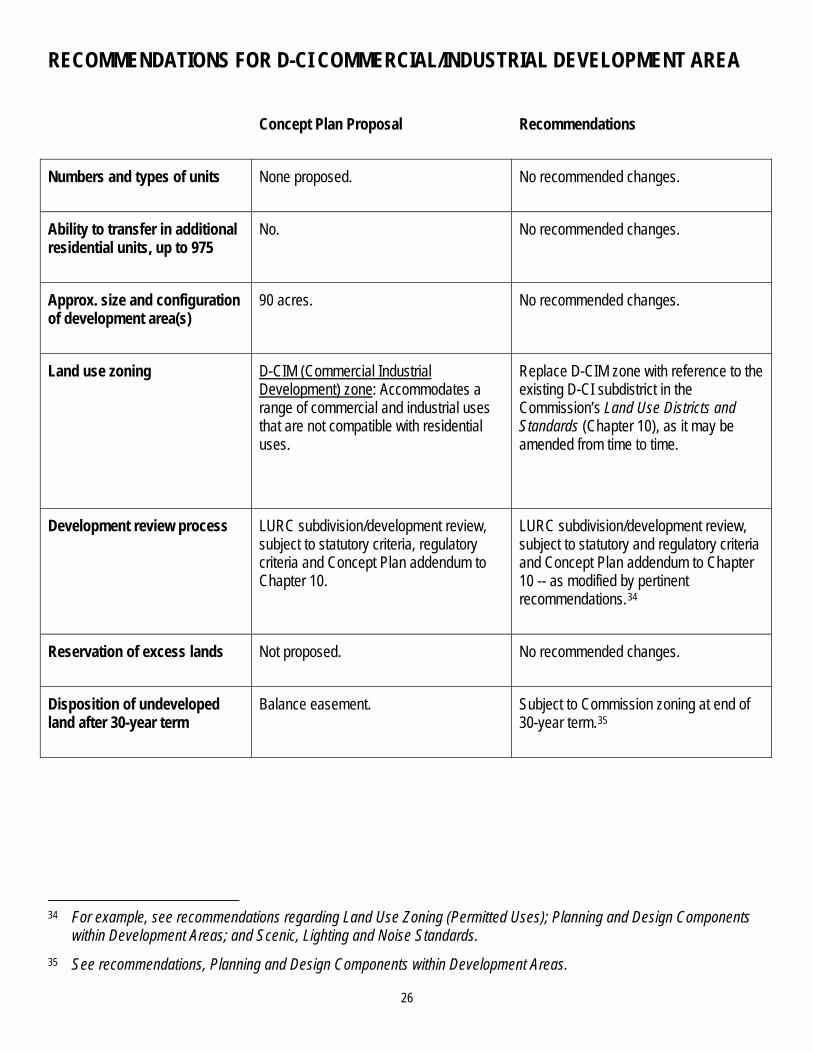
The following recommendations address Plum Creek’s proposal to rezone approximately 90 acres for commercial and industrial development in Taunton & Raynham Township. Pertinent details of Plum Creek’s proposal for this development area are set forth in the table that follows.
25
26
RECOMMENDATIONS FOR D-CI COMMERCIAL/INDUSTRIAL DEVELOPMENT AREA Concept Plan Proposal Recommendations
Numbers and types of units None proposed. No recommended changes.
Ability to transfer in additional residential units, up to 975
No. No recommended changes.
Approx. size and configuration of development area(s)
90 acres. No recommended changes.
Land use zoning D-CIM (Commercial Industrial Development) zone: Accommodates a range of commercial and industrial uses that are not compatible with residential uses.
Replace D-CIM zone with reference to the existing D-CI subdistrict in the Commission’s Land Use Districts and Standards (Chapter 10), as it may be amended from time to time.
Development review process LURC subdivision/development review, subject to statutory criteria, regulatory criteria and Concept Plan addendum to Chapter 10.
LURC subdivision/development review, subject to statutory and regulatory criteria and Concept Plan addendum to Chapter 10 -- as modified by pertinent recommendations.34
Reservation of excess lands Not proposed. No recommended changes.
Disposition of undeveloped land after 30-year term
Balance easement. Subject to Commission zoning at end of 30-year term.35
34 For example, see recommendations regarding Land Use Zoning (Permitted Uses); Planning and Design Components
within Development Areas; and Scenic, Lighting and Noise Standards. 35 See recommendations, Planning and Design Components within Development Areas.

ROUTE 6/15 DEVELOPMENT AREA
The following recommendations address Plum Creek’s proposal to rezone approximately 3,349 acres for development on Moosehead Lake in Taunton & Raynham Township to accommodate approximately 125 residential dwelling units. Pertinent details of Plum Creek’s proposal for this development area are set forth in the table that follows.
27

28
RECOMMENDATIONS FOR THE ROUTE 6/15 DEVELOPMENT AREA
Concept Plan Proposal Recommendations
Numbers and types of units
1. Residential units Uncapped (125 planned).
2. Resort accommodation units None proposed.
3. Caretaker/manager housing Uncapped.
4. Affordable housing Uncapped.
5. Employee housing None proposed.
No recommended changes.
Ability to transfer in additional residential units, up to 975
Yes (potential receiving area). No recommended changes.
Approx. size and configuration of development area(s)
Total: 3,349 acres, including 4,561 feet of shorefront on Moosehead Lake.
1,854 acres (D-RS3M zone -- north).
153 acres (D-RS3M zone -- south).
87 acres (D-GN3M zone).
No recommended changes.

29
RECOMMENDATIONS FOR THE ROUTE 6/15 DEVELOPMENT AREA (CONTINUED)
Concept Plan Proposal Recommendations
Land use zoning D-RS3M (Residential Recreation Development) zone: Accommodates predominantly residential subdivisions comprised only of single family dwellings.
D-GN3M (Rural Mixed-Use Development) zone: Accommodates both commercial and residential uses, which have a similar size, scale and character as the uses allowed in the residential zones.
Replace D-RS3M and M-GNM zones with new D-MH-RS1 zone that would:
1. allow primarily residential development (both single and multi-family, including affordable housing) as well as public/civic uses and facilities, home occupations and other uses compatible with residential development; and
2. also allow neighborhood-scale commercial facilities and uses by special exception, but would impose gross floor area restrictions on such facilities and uses, and would limit land devoted to commercial uses to 50 acres in the aggregate.36
Development review process LURC subdivision/development review, subject to statutory criteria, regulatory criteria and Concept Plan addendum to Chapter 10.
Replace with a 2-step process:
1. Require the filing of a long-term development plan no later than the submission of the first subdivision/ development application; and
2. LURC subdivision/development review, subject to statutory and regulatory criteria and Concept Plan addendum to Chapter 10 -- as modified by pertinent recommendations.37
36 Neighborhood-scale commercial uses and facilities could include, for example, a general store, restaurant, canoe/kayak
rental office, small-scale commercial marina, laundromat, day spa, artisan shop, retail stores and services, and subdivisions for such uses. See recommendations, Land Use Zoning (Permitted Uses).
37 For example, see recommendations, Land Use Zoning (Permitted Uses); Planning and Design Components within Development Areas; and Scenic, Lighting and Noise Standards.

30
RECOMMENDATIONS FOR THE ROUTE 6/15 DEVELOPMENT AREA (CONTINUED)
Concept Plan Proposal Recommendations
Reservation of excess lands Not proposed. No recommended changes.
Disposition of undeveloped land after 30-year term
Balance easement. Subject to Commission zoning at end of 30-year term.38
Limitations on shoreland structures
Not proposed. Limit shoreland structures (including temporary docks, moorings, and boat launches) to no more than four common water access points that would serve the entire development area (if a resort-related access point or commercial marina were built, this would count as one of the four).
38 See recommendations, Planning and Design Components within Development Areas.

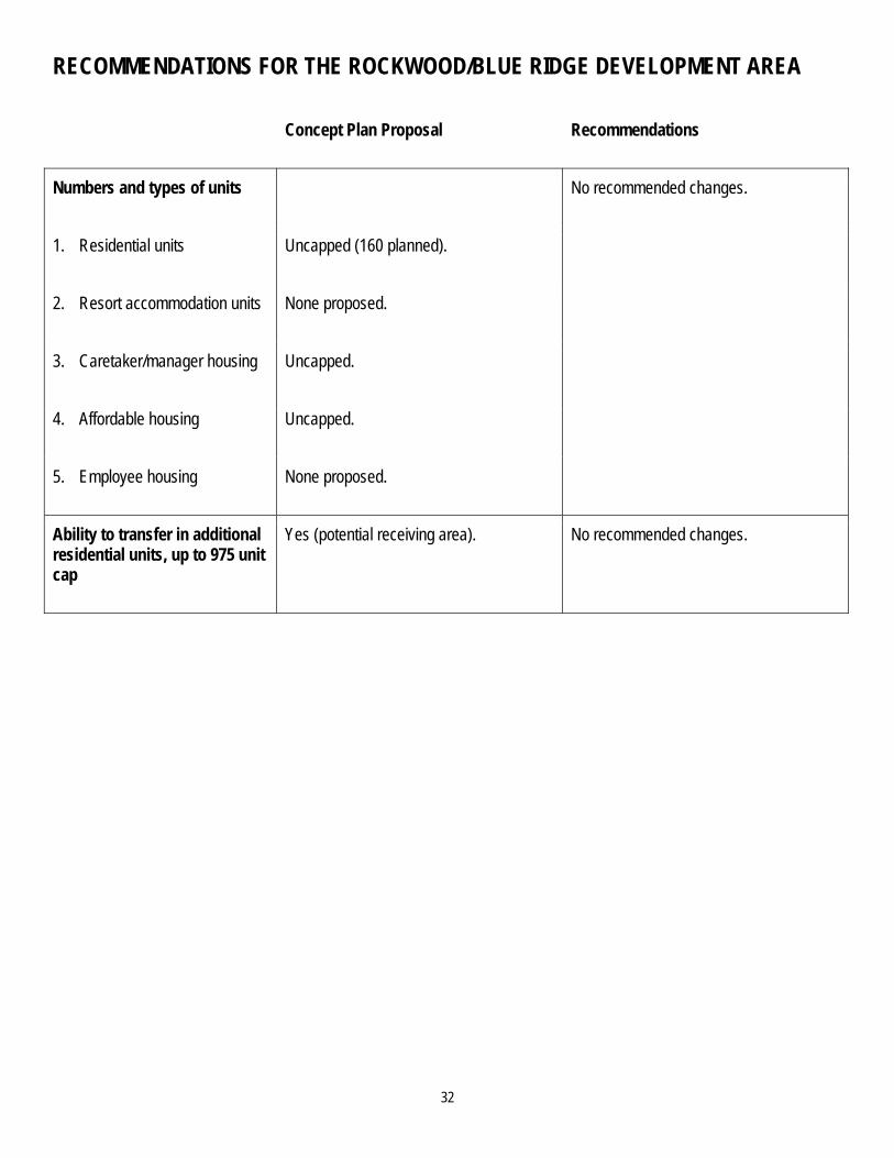
ROCKWOOD/BLUE RIDGE DEVELOPMENT AREA
The following recommendations address Plum Creek’s proposal to rezone approximately 3,902 acres for development, plus approximately 290 acres for general management, in Rockwood Strip and Taunton & Raynham Townships to accommodate approximately 160 residential dwelling units. Pertinent details of Plum Creek’s proposal for this development area are set forth in the table that follows.
31
32
RECOMMENDATIONS FOR THE ROCKWOOD/BLUE RIDGE DEVELOPMENT AREA
Concept Plan Proposal Recommendations
Numbers and types of units
1. Residential units Uncapped (160 planned).
2. Resort accommodation units None proposed.
3. Caretaker/manager housing Uncapped.
4. Affordable housing Uncapped.
5. Employee housing None proposed.
No recommended changes.
Ability to transfer in additional residential units, up to 975 unit cap
Yes (potential receiving area). No recommended changes.

33
RECOMMENDATIONS FOR THE ROCKWOOD/BLUE RIDGE DEVELOPMENT AREA (CONTINUED)
Concept Plan Proposal Recommendations
Approx. size and configuration of development area(s)
Total: 4,092 acres, including 7,754 feet of shorefront on Brassua Lake and 1,340 feet of shorefront on Moosehead Lake.
181 acres (D-RS2M zone – near Brassua Dam).
860 acres (D-RS2M zone -- near Brassua Lake).
628 acres (D-RS2M zone -- near Rockwood Village).
1,998 acres (D-RS3M zone -- Blue Ridge southeast side).
235 acres (D-GN3M zone).
190 acres (M-GNM zone).
Remove from the D-RS2M zone (near Brassua Lake) a portion of waterfowl and wading bird habitat and its associated 250-foot buffer; add this acreage to Balance conservation easement acreage.39
Add acreage proposed for M-GNM zoning to Balance conservation easement acreage.
39 IFW/MNAP’s August 31, 2007 comments state that, at full build-out, development in the Rockwood/Blue Ridge
development area “could significantly alter, restrict and possibly eliminate movement of various wildlife species along and over the ridge.” Therefore, staff/consultants recommend that development in this area must be specifically designed so as to not obstruct the overland movement of wildlife, and that such a showing must be made upon the filing of a long-term development plan (see recommendations, Planning and Design Components within Development Areas).

34
RECOMMENDATIONS FOR THE ROCKWOOD/BLUE RIDGE DEVELOPMENT AREA (CONTINUED)
Concept Plan Proposal Recommendations
Land use zoning D-RS2M (Community Residential Development) zone: Accommodates predominantly residential subdivisions and a range of housing types, including multi-family dwellings, as well as community facilities and major home occupations.
D-RS3M (Residential Recreation Development) zone: Accommodates predominantly residential subdivisions comprised only of single family dwellings.
D-GN3M (Rural Mixed-Use Development) zone: Accommodates both commercial and residential uses, which have a similar size, scale and character as the uses allowed in the residential zones.
M-GNM (General Management) zone: Prohibits, inter alia, residential development.
Replace D-RS2M, D-RS3M and D-GN3M zones with new D-MH-RS1 zone that would:
1. allow primarily residential development (both single and multi-family, including affordable housing) as well as public/civic uses and facilities, home occupations and other uses compatible with residential development; and
2. also allow neighborhood-scale commercial facilities and uses by special exception, but would impose gross floor area restrictions on such facilities and uses, and would limit land devoted to commercial uses to an area within 1,000 feet of Route 6/15 near Rockwood Village (i.e. the proposed location of the D-GN3M zone), and 25 acres in the aggregate elsewhere.40
Add acreage proposed for M-GNM zoning to Balance conservation easement acreage.
40 Neighborhood-scale commercial uses and facilities could include, for example, a general store, restaurant, canoe/kayak
rental office, small-scale commercial marina, laundromat, day spa, artisan shop, retail stores and services, and subdivisions for such uses. See recommendations, Land Use Zoning (Permitted Uses).

35
RECOMMENDATIONS FOR THE ROCKWOOD/BLUE RIDGE DEVELOPMENT AREA (CONTINUED)
Concept Plan Proposal Recommendations
Development review process LURC subdivision/development review, subject to statutory criteria, regulatory criteria and Concept Plan addendum to Chapter 10.
Replace with a 2-step process:
1. Require the filing of a long-term development plan no later than the submission of the first subdivision/ development application; and
2. LURC subdivision/development review, subject to statutory and regulatory criteria and Concept Plan addendum to Chapter 10 -- as modified by pertinent recommendations.41
Reservation of excess lands Not proposed. Require reservation of at least 50% of developable land for future community needs.42
Disposition of undeveloped land after 30-year term
Balance easement. Subject to Commission zoning at end of 30-year term.43
Limitations on shoreland structures
Not proposed. No recommended changes.
41 For example, see recommendations, Land Use Zoning (Permitted Uses); Planning and Design Components within
Development Areas; and Scenic, Lighting and Noise Standards. 42 See recommendations, Planning and Design Components within Development Areas. 43 Ibid.

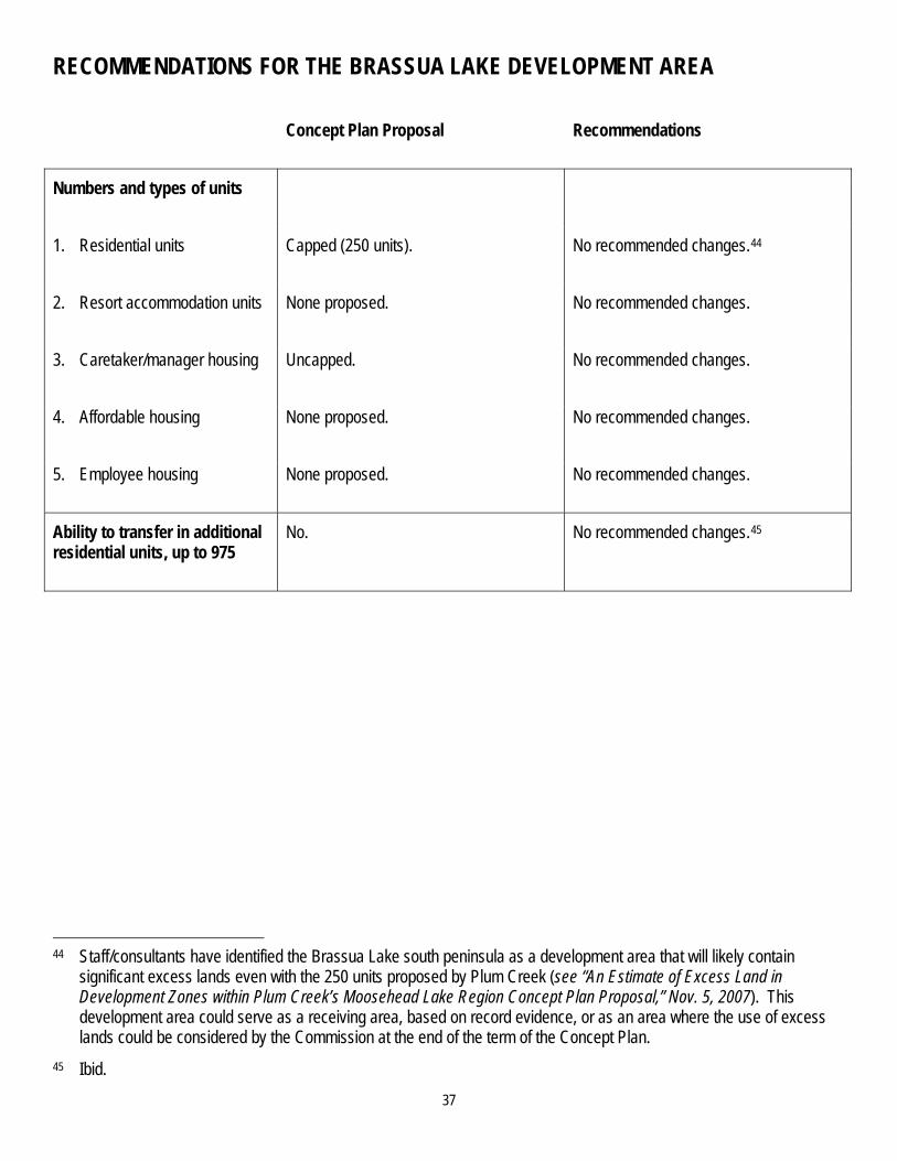
BRASSUA LAKE DEVELOPMENT AREA
The following recommendations address Plum Creek’s proposal to rezone approximately 2,872 acres for development on Brassua Lake to accommodate up to 250 residential dwelling units. Pertinent details of Plum Creek’s proposal for this development area are set forth in the table that follows.
36
37
RECOMMENDATIONS FOR THE BRASSUA LAKE DEVELOPMENT AREA
Concept Plan Proposal Recommendations
Numbers and types of units
1. Residential units Capped (250 units). No recommended changes.44
2. Resort accommodation units None proposed. No recommended changes.
3. Caretaker/manager housing Uncapped. No recommended changes.
4. Affordable housing None proposed. No recommended changes.
5. Employee housing None proposed. No recommended changes.
Ability to transfer in additional residential units, up to 975
No. No recommended changes.45
44 Staff/consultants have identified the Brassua Lake south peninsula as a development area that will likely contain
significant excess lands even with the 250 units proposed by Plum Creek (see “An Estimate of Excess Land in Development Zones within Plum Creek’s Moosehead Lake Region Concept Plan Proposal,” Nov. 5, 2007). This development area could serve as a receiving area, based on record evidence, or as an area where the use of excess lands could be considered by the Commission at the end of the term of the Concept Plan.
45 Ibid.
38
RECOMMENDATIONS FOR THE BRASSUA LAKE DEVELOPMENT AREA (CONTINUED)
Concept Plan Proposal Recommendations
Approx. size and configuration of development area(s)
Total: 2,872 acres, including 52,085 feet of shorefront on Brassua Lake.
2,721 acres (D-RS2M zone – south peninsula).
60 acres (D-RS3M zone -- northeast shore).
91 acres (two D-GN3M zones on south peninsula).
Place four waterfowl and wading bird habitats on the south peninsula and their associated 250-foot buffers off-limits to development (two of these areas, on the far southwest and the far southeast corners of the peninsula, would be added to Balance easement acreage; the other two would remain part of the development area but as no disturbance areas).46
Modify the west boundary of the south peninsula to avoid visibility of development on the peninsula from Little Brassua Lake.47
46 IFW/MNAP’s August 31, 2007 comments also include a recommendation to remove from the proposed Brassua Lake
south peninsula development area a buffer along both sides of Misery Stream as it approaches the lake. Staff/consultants instead recommend adopting a “no disturbance buffer” land use standard that would apply within 250 feet of either side of Misery Stream. This would avoid fragmenting the development area while providing a comparable level of protection for the identified natural resource values in this area.
47 See the topographic map, below, for an illustration of this recommendation.

39
RECOMMENDATIONS FOR THE BRASSUA LAKE DEVELOPMENT AREA (CONTINUED)
Concept Plan Proposal Recommendations
Land use zoning D-RS2M (Community Residential Development) zone: Accommodates predominantly residential subdivisions and a range of housing types, including multi-family dwellings, as well as community facilities and major home occupations.
D-RS3M (Residential Recreation Development) zone: Accommodates predominantly residential subdivisions comprised only of single family dwellings.
D-GN3M (Rural Mixed-Use Development) zone: Accommodates both commercial and residential uses, which have a similar size, scale and character as the uses allowed in the residential zones.
Replace D-RS2M, D-RS3M and D-GN3M zones with new D-MH-RS1 zone that would:
1. allow primarily residential development (both single and multi-family, including affordable housing) as well as public/civic uses and facilities, home occupations and other uses compatible with residential development; and
2. also allow neighborhood-scale commercial facilities and uses by special exception on the Brassua Lake south peninsula, but would impose gross floor area restrictions on such facilities and uses, and would limit land devoted to commercial uses to 50 acres in the aggregate.48
48 Neighborhood-scale commercial uses and facilities could include, for example, a general store, restaurant, canoe/kayak
rental office, small-scale commercial marina, laundromat, day spa, artisan shop, retail stores and services, and subdivisions for such uses. See recommendations, Land Use Zoning (Permitted Uses).

40
RECOMMENDATIONS FOR THE BRASSUA LAKE DEVELOPMENT AREA (CONTINUED)
Concept Plan Proposal Recommendations
Development review process LURC subdivision/development review, subject to statutory criteria, regulatory criteria and Concept Plan addendum to Chapter 10.
Replace with a 2-step process:
1. Require the filing of a long-term development plan no later than the submission of the first subdivision/ development application; and
2. LURC subdivision/development review, subject to statutory and regulatory criteria and Concept Plan addendum to Chapter 10 -- as modified by pertinent recommendations.49
Reservation of excess lands Not proposed. Require reservation of at least 25% of developable land for future community needs.50
Disposition of undeveloped land after 30-year term
Balance easement. Subject to Commission zoning at end of 30-year term.51
Limitations on shoreland structures
Not proposed. Limit shoreland structures (including temporary docks, moorings, and boat launches) to no more than ten common water access point that would serve the development area on the south peninsula; no limitations on the northeast shore.
49 For example, see recommendations, Land Use Zoning (Permitted Uses); Planning and Design Components within
Development Areas; and Scenic, Lighting and Noise Standards. 50 See recommendations, Planning and Design Components within Development Areas. 51 Ibid.

RECOMMENDATIONS FOR THE BRASSUA LAKE DEVELOPMENT AREA (CONTINUED)
Recommended configuration change to the west boundary of the Brassua Lake south peninsula development area in order to protect Little Brassua Lake from scenic impacts.
41

LONG POND DEVELOPMENT AREA
The following recommendations address Plum Creek’s proposal to rezone approximately 1,500 acres for development on Long Pond to accommodate up to 110 residential dwelling units. Pertinent details of Plum Creek’s proposal for this development area are set forth in the table that follows.
42

43
RECOMMENDATIONS FOR THE LONG POND DEVELOPMENT AREA Concept Plan Proposal Recommendations
Numbers and types of units
1. Residential units Capped (110 units). Capped at 55 residential units.52
2. Resort accommodation units None proposed. No recommended changes.
3. Caretaker/manager housing Uncapped. No recommended changes.
4. Affordable housing None proposed. Permitted use, subject to 55-unit cap.
5. Employee housing None proposed. No recommended changes.
Ability to transfer in additional residential units, up to 975
No. No recommended changes.
Approx. size and configuration of development area(s)
Total: 1,500 acres, including 32,985 feet of shorefront on Long Pond.
323 acres (D-RS3M zone - northeast shore).
250 acres (D-RS3M zone - northwest shore).
912 acres (D-RS3M zone - southeast shore).
15 acres (D-RS3M zone - southwest shore).
Remove D-RS3M northeast and northwest shore zones; add these areas to Balance conservation easement acreage.
Place waterfowl and wading bird habitat located on the southeast shore and its associated 250-foot buffer off-limits to development, keeping it part of the development zone but as a no disturbance area.
No recommended changes to southwest shore.
52 The number of units within this development area would be permanently capped at 55 total units, with actual number
and location of units based on subdivision review and approval. Permanency of the cap would be accomplished not through donation of unused lands to the ‘Balance’ conservation easement following build-out of 55 units, as currently proposed by Plum Creek, but instead through restrictive covenants on land within the zone extinguishing additional development rights beyond 55 units. These restrictive covenants would be placed on the land at the time of Concept Plan approval. Thus, these restrictive covenants would permanently preclude additional development of residential units (including vertical expansion of such units) but not add acreage to the ‘Balance’ conservation easement.

44
RECOMMENDATIONS FOR THE LONG POND DEVELOPMENT AREA (CONTINUED) Concept Plan Proposal Recommendations
Land use zoning D-RS3M (Residential Recreation Development) zone: Accommodates predominantly residential subdivisions comprised only of single family dwellings.
Replace D-RS3M zone with new D-MH-RS1 zone to allow primarily residential development (both single and multi-family, including affordable housing) as well as public/civic uses and facilities, home occupations and other uses compatible with residential development, and to prohibit commercial or industrial uses.53
Development review process LURC subdivision/development review, subject to statutory criteria, regulatory criteria and Concept Plan addendum to Chapter 10.
LURC subdivision/development review, subject to statutory and regulatory criteria and Concept Plan addendum to Chapter 10 -- as modified by pertinent recommendations.54
Reservation of excess lands Not proposed. No recommended changes.
Disposition of undeveloped land after 30-year term
Balance easement. Restrictive covenant (see footnote 52, above).
Limitations on shoreland structures
Not proposed. Limit shoreland structures (including docks, moorings, and boat launches) to no more than two common water access points in the southeast shore area.
No limitations recommended in the southwest shore area.
53 See recommendations, Land Use Zoning (Permitted Uses). 54 For example, see recommendations, Land Use Zoning (Permitted Uses); Planning and Design Components within
Development Areas; and Scenic, Lighting and Noise Standards.

45
TOTAL NUMBER OF UNITS
The Concept Plan includes the following restrictions regarding the total number of units that could be built within the plan area during the 30-year term of the Concept Plan:
Total number of residential units capped at 975.
Distribution of total units as follows:
» Beaver Cove 32 units (estimated, potential receiving area)
» Upper Wilson Pond 32 units (capped)
» Lily Bay 154 units (capped)
» Big Moose Mountain 0 units (potential receiving area)
» Moose Bay 112 units (estimated, potential receiving area)
» D-CI Zone 0 units (capped)
» Route 6/15 Corridor 125 units (estimated, potential receiving area)
» Rockwood/Blue Ridge 160 units (estimated, potential receiving area)
» Brassua Lake 250 units (capped)
» Long Pond 110 units (capped)
Total number of resort accommodation units capped at 1,050 (800 in the Big Moose Mountain development area; 250 in the Lily Bay development area).
Unlimited number of caretaker/manager, affordable and employee housing units in certain development areas.
In addition, Plum Creek proposes, at the end of the 30-year term of the Concept Plan, to increase the “Balance” conservation easement acreage by the amount of land area within the development zones that remain undeveloped and outside homeowner associations or subdivisions, “thereby eliminating all unused and potential development rights forever.”
RECOMMENDATIONS REGARDING TOTAL NUMBER OF UNITS Staff/consultants recommend that the total number of residential and resort accommodation units for the 30-year term of the Concept Plan be capped at 2,025. Detailed recommendations regarding (1) the proposed sub-caps for each development area and (2) the expansion of the “Balance” conservation easement acreage into development areas upon build-out are included in specific recommendations for Proposed Development Areas, above.

46
PROPOSED LAND USE ZONES AND STANDARDS

LAND USE ZONING (PERMITTED USES)
The following recommendations address Plum Creek’s proposal to apply to the Concept Plan area five development zones (residential D-RS2M and D-RS3M, mixed use D-GN3M, resort D-GN2M and commercial/industrial D-CIM), one management zone (M-GNM); and numerous protection zones. Pertinent details of Plum Creek’s proposed land use zones and associated permitted uses are set forth in the table that follows.
47

48
RECOMMENDATIONS REGARDING LAND USE ZONING (PERMITTED USES): OVERVIEW
Development Zoning
Staff/consultants recommend that the Commission amend Plum Creek’s proposed residential (D-RS2M, D-RS3M), mixed use (D-GN3M), resort (D-GN2M) and commercial/industrial (D-CIM) zones by adopting staff/consultants’ recommended zones (see table, below) for the following reasons:
1. To establish a clear hierarchy of permitted land uses based on the proximity of development areas to existing communities and infrastructure;
2. To allow a range of residential units (including duplexes, multi-family dwellings, and affordable housing) in most development areas;
3. To allow an appropriate range of public/civic, commercial and other non-residential uses within development areas (i.e., mixed uses); and
4. To simplify the administration of the Concept Plan by applying, where possible, established LURC vernacular and zoning approach.
Management Zoning
Staff/consultants recommend:
1. Adding several proposed M-GNM zones to either adjoining conservation easement lands or adjoining development areas;
2. Continuing to apply M-GNM zoning to all “Balance” and “Legacy” conservation easement areas; and
3. Modifying the M-GNM list of permitted uses to allow campgrounds, back country huts and potentially other uses and facilities that would be permitted uses under the terms of the conservation easements.55
Protection Zoning
Staff/consultants recommend that the Commission approve the treatment of boundaries and permitted uses of protection zones adjoining or encompassed by development areas as proposed in the Concept Plan, so long as the specific recommendations proposed herein are adopted by the Commission.
55 See recommendations, Offset Conservation: Balance Conservation Easement and Conservation Framework:
Moosehead Legacy Easement.

49
COMPARISON OF PROPOSED LAND USE ZONING TO RECOMMENDATIONS: DEVELOPMENT ZONING
Concept Plan Proposal Recommendations
Proposed residential development zones (D-RS2M, D-RS3M)
Residential development would be primarily, but not exclusively, in areas zoned as:
D-RS2M – Community Residential Development Zone: Accommodates predominantly residential subdivisions and a range of housing types, including multi-family dwellings, as well as community facilities and major home occupations. Development areas affected by this zone would be: Portions of Rockwood/Blue Ridge; Portion of Lily Bay; Brassua Lake south peninsula; and Moose Bay.
D-RS3M – Residential Recreation Development Zone: Accommodates predominantly residential subdivisions comprised only of single family dwellings. Development areas affected by this zone would be: Beaver Cove; Upper Wilson Pond; Portion of Lily Bay; Route 6/15 Corridor; Portions of Rockwood/Blue Ridge; and Brassua Lake northeast shore.
Proposed mixed-use development zone (D-GN3M)
Mixed use development would be in areas zoned as:
D-GN3M -- Rural Mixed-Use Development Zone: Located adjacent to or within some development areas; accommodates both commercial and residential uses, which have a similar size, scale and character as the uses allowed in the residential zones. Development areas affected by this zone would be: Two portions of Brassua Lake south peninsula; Portion of Rockwood/Blue Ridge; Portion of Route 6/15 Corridor; and Portion of Moose Bay.
Staff/consultants recommend the creation of one zone to accommodate residential and neighborhood-scale commercial development:
Residential development zone (D-MH-RS1)
Allows residential development (including single-family dwellings, duplexes, and multi-family dwellings -- i.e. condominiums, townhouses) and affordable housing, as well as public/civic structures and uses, home occupations and other uses compatible with residential development.
In certain development areas, also allows neighborhood-scale commercial facilities and uses (e.g., restaurant, canoe/kayak rental office, small-scale commercial marina, laundromat, day spa, artisan shop, general store) by special exception, impose gross floor area restrictions on such facilities and uses, and limit land devoted to commercial uses in each development area to a maximum aggregate acreage. Development areas affected by this zone would be: Beaver Cove Upper Wilson Pond Long Pond -- Southeast Shore Long Pond -- Southwest Shores Brassua Lake Northeast Shore Brassua Lake South Peninsula *
(land for commercial uses limited to max. aggregate size of 50 acres)
Route 6/15 Corridor * (land for commercial uses limited to max. aggregate size of 50 acres)
Rockwood/Blue Ridge * (land for commercial uses unlimited within 1000 feet of Route 6/15 near Rockwood Village, and limited to max. aggregate size of 25 acres elsewhere)
* Neighborhood-scale commercial structures and uses would be allowed uses by special exception in these development areas.
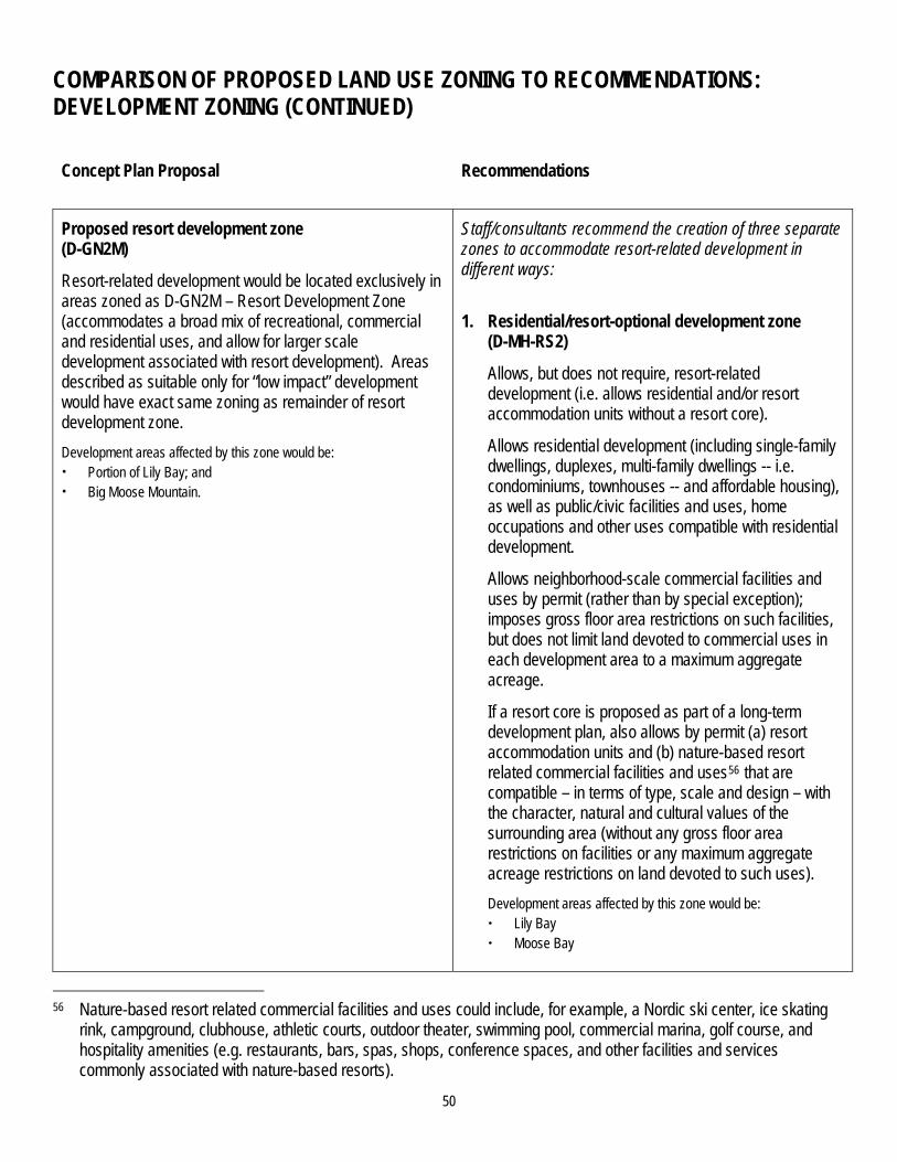
50
COMPARISON OF PROPOSED LAND USE ZONING TO RECOMMENDATIONS: DEVELOPMENT ZONING (CONTINUED)
Concept Plan Proposal Recommendations
Proposed resort development zone (D-GN2M)
Resort-related development would be located exclusively in areas zoned as D-GN2M – Resort Development Zone (accommodates a broad mix of recreational, commercial and residential uses, and allow for larger scale development associated with resort development). Areas described as suitable only for “low impact” development would have exact same zoning as remainder of resort development zone. Development areas affected by this zone would be: Portion of Lily Bay; and Big Moose Mountain.
Staff/consultants recommend the creation of three separate zones to accommodate resort-related development in different ways:
1. Residential/resort-optional development zone (D-MH-RS2)
Allows, but does not require, resort-related development (i.e. allows residential and/or resort accommodation units without a resort core).
Allows residential development (including single-family dwellings, duplexes, multi-family dwellings -- i.e. condominiums, townhouses -- and affordable housing), as well as public/civic facilities and uses, home occupations and other uses compatible with residential development.
Allows neighborhood-scale commercial facilities and uses by permit (rather than by special exception); imposes gross floor area restrictions on such facilities, but does not limit land devoted to commercial uses in each development area to a maximum aggregate acreage.
If a resort core is proposed as part of a long-term development plan, also allows by permit (a) resort accommodation units and (b) nature-based resort related commercial facilities and uses56 that are compatible – in terms of type, scale and design – with the character, natural and cultural values of the surrounding area (without any gross floor area restrictions on facilities or any maximum aggregate acreage restrictions on land devoted to such uses). Development areas affected by this zone would be: Lily Bay Moose Bay
56 Nature-based resort related commercial facilities and uses could include, for example, a Nordic ski center, ice skating
rink, campground, clubhouse, athletic courts, outdoor theater, swimming pool, commercial marina, golf course, and hospitality amenities (e.g. restaurants, bars, spas, shops, conference spaces, and other facilities and services commonly associated with nature-based resorts).

51
COMPARISON OF PROPOSED LAND USE ZONING TO RECOMMENDATIONS: DEVELOPMENT ZONING (CONTINUED)
Concept Plan Proposal Recommendations
2. Resort development zone (D-MH-RT)
Requires nature-based resort development (allows residential and/or resort accommodation units only in proportion to growth of a resort core and short-term visitor accommodations).57
Allows nature-based resort related commercial facilities and uses58 that are part of a resort core and are compatible – in terms of type, scale and design – with the character, natural and cultural values of the surrounding area (without any gross floor area restrictions on facilities or any maximum aggregate acreage restrictions on land devoted to such uses).
In addition, allows other structures, uses or services that are incorporated into a long-term development plan and determined by the Commission to be consistent with the purposes of this zone, the Concept Plan and Commission’s Comprehensive Land Use Plan. Development areas affected by this zone would be Big Moose Mountain, including Deep Cove (Moosehead Lake) and Burnham Pond north shore, but excluding Indian Pond.
3. Primitive resort development zone (D-MH-PR)
Restricts permitted uses to primitive resort accommodations, uses and structures, modeled on intensity and type characterized by LURC’s current definition for commercial sporting camps.
Prohibits subdivision of land in this zone. Development areas affected by this zone would be Big Moose Mountain – Indian Pond shore, and Lily Bay Mountain.
57 See recommendations, Proposed Development Areas: Big Moose Mountain.
58 Nature-based resort related commercial facilities and uses could include, for example, a Nordic ski center, ice skating rink, campground, clubhouse, athletic courts, outdoor theater, swimming pool, commercial marina, golf course, and hospitality amenities (e.g. restaurants, bars, spas, shops, conference spaces, and other facilities and services commonly associated with nature-based resorts).

52
COMPARISON OF PROPOSED LAND USE ZONING TO RECOMMENDATIONS: DEVELOPMENT ZONING (CONTINUED)
Concept Plan Proposal Recommendations
Commercial/industrial zone (D-CIM)
Intensive commercial or industrial uses would be located in one area currently zoned as D-CIM – Commercial Industrial Development Zone (accommodates a range of commercial and industrial uses that are not compatible with residential uses).
Commercial/industrial zone (D-CI)
Replace D-CIM zone with reference to current D-CI zone in Chapter 10, as may be amended from time to time.
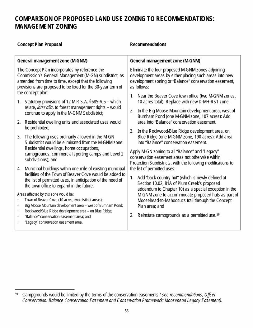
53
COMPARISON OF PROPOSED LAND USE ZONING TO RECOMMENDATIONS: MANAGEMENT ZONING
Concept Plan Proposal Recommendations
General management zone (M-GNM)
The Concept Plan incorporates by reference the Commission’s General Management (M-GN) subdistrict, as amended from time to time, except that the following provisions are proposed to be fixed for the 30-year term of the concept plan:
1. Statutory provisions of 12 M.R.S.A. §685-A,5 – which relate, inter alia, to forest management rights – would continue to apply in the M-GNM Subdistrict;
2. Residential dwelling units and associated uses would be prohibited;
3. The following uses ordinarily allowed in the M-GN Subdistrict would be eliminated from the M-GNM zone: Residential dwellings, home occupations, campgrounds, commercial sporting camps and Level 2 subdivisions); and
4. Municipal buildings within one mile of existing municipal facilities of the Town of Beaver Cove would be added to the list of permitted uses, in anticipation of the need of the town office to expand in the future.
Areas affected by this zone would be: Town of Beaver Cove (10 acres, two distinct areas); Big Moose Mountain development area – west of Burnham Pond; Rockwood/Blue Ridge development area – on Blue Ridge; “Balance” conservation easement area; and “Legacy” conservation easement area.
General management zone (M-GNM)
Eliminate the four proposed M-GNM zones adjoining development areas by either placing such areas into new development zoning or “Balance” conservation easement, as follows:
1. Near the Beaver Cove town office (two M-GNM zones, 10 acres total): Replace with new D-MH-RS1 zone.
2. In the Big Moose Mountain development area, west of Burnham Pond (one M-GNM zone, 107 acres): Add area into “Balance” conservation easement.
3. In the Rockwood/Blue Ridge development area, on Blue Ridge (one M-GNM zone, 190 acres): Add area into “Balance” conservation easement.
Apply M-GN zoning to all “Balance” and “Legacy” conservation easement areas not otherwise within Protection Subdistricts, with the following modifications to the list of permitted uses:
1. Add “back country hut” (which is newly defined at Section 10.02, 81A of Plum Creek’s proposed addendum to Chapter 10) as a special exception in the M-GNM zone to accommodate proposed huts as part of Moosehead-to-Mahoosucs trail through the Concept Plan area; and
2. Reinstate campgrounds as a permitted use.59
59 Campgrounds would be limited by the terms of the conservation easements ( see recommendations, Offset
Conservation: Balance Conservation Easement and Conservation Framework: Moosehead Legacy Easement).

54
COMPARISON OF PROPOSED LAND USE ZONING TO RECOMMENDATIONS: PROTECTION ZONING
Concept Plan Proposal Recommendations
Protection zones adjoining or encompassed by development areas
Except for portions of P-GP Subdistricts, the current classifications of all existing Protection Subdistricts that adjoin or are encompassed by development areas would be retained. The purposes, descriptions, and land uses listed in each of the Commission’s Protection Subdistricts, as amended by LURC from time to time, would be incorporated by reference, except that the following provisions would be fixed for 30 years:
1. Protection zone boundaries: The boundaries of any protection zone in place within a development area at the time of Concept Plan approval; boundaries partially within or adjacent to development areas could not expand or extend into development areas.60
2. Permitted uses: Installation or construction of (1) roads, (2) water crossings, (3) trails and (4) boat launches, as such uses were provided for within each Protection Subdistrict on August 31, 2007.
3. Land use standards: Land use standards included in the Chapter 10 addendum, which could implicate how permitted uses within protection zones would be regulated (e.g., noise standards, stream setback requirements, vegetation clearing standards).
Staff/consultants recommend that the Commission approve the treatment of boundaries and permitted uses of protection zones adjoining or encompassed by development areas as proposed in the Concept Plan, so long as the Concept Plan also explicitly acknowledges and endorses the Commission’s legal authority to:
(a) review any long-term development plans, subdivision applications, or other development-specific permit requests based upon the standards and restrictions contained in natural resources laws and regulations in effect at the time of permit request (regardless of whether the natural resource law or regulation is stricter than what exists at the time of Concept Plan approval), and
(b) require the applicant for this permit to meet these standards and restrictions, unless the applicant can affirmatively demonstrate that the protections achieved by these current laws and regulations are unnecessary given site-specific considerations, or could be achieved in another way.61
Staff/consultants further recommend that at the time of subdivision or other site-specific development application, Plum Creek agrees to submit natural resources inventory maps that depict for the proposed development area all protected natural resources and resulting protection areas, based upon natural resources laws and regulations in effect at the time of application.
60 This means that development areas could not be rezoned to a protection subdistrict for the term of the plan, either via
expansion of an existing protection zone or by creation of a new type of resource protection zone that may not exist at the time of Concept Plan approval but, based on science or evolving conditions, is subsequently created by the Commission.
61 In testimony provided to the Commission by Plum Creek’s in-house and outside legal counsel on January 24, 2008 (James Kraft and John Hempelmann), each witness stated that this was his legal view of how the review process would work, and offered Plum Creek’s support for this approach by the Commission.

55
COMPARISON OF PROPOSED LAND USE ZONING TO RECOMMENDATIONS: PROTECTION ZONING (CONTINUED)
Concept Plan Proposal Recommendations
Protection zones in easement areas
The Concept Plan would not alter existing Chapter 10 standards and practices to Protection Subdistricts located outside of development areas, meaning that amendments to Protection Subdistrict boundaries, permitted uses, and land use standards (except those standards included in the proposed addendum to Chapter 10) would occur in the same way as occurs in the rest of LURC’s jurisdiction.
No recommended changes.
56
PLANNING AND DESIGN COMPONENTS WITHIN DEVELOPMENT AREAS
SUMMARY OF KEY ELEMENTS OF CONCEPT PLAN PROPOSAL FOR PLANNING AND DESIGN WITHIN DEVELOPMENT AREAS Within proposed residential, mixed-use and commercial/industrial development areas, subdivision layout/design and placement of structures and uses would be determined at the subdivision/development review stage, subject to the provisions of:
Statutory criteria, including 12 M.R.S.A. §685-B(4) Criteria for Approval;
Sub-Chapter III of the Commission’s Land Use Districts and Standards, including Section 10.24 General Criteria for Approval of Permit Applications and Section 10.25 Development Standards; and
Concept Plan addendum (so-called “pocket part”) to the Commission’s Land Use Districts and Standards, including modifications to the Commission’s existing subdivision layout and design standards (Section 10.25,Q,3).
Within proposed resort development areas (Big Moose Mountain and Lily Bay), subdivision layout/design and placement of structures and uses would be determined by a three-step review process comprised of a Resort Master Plan, Site-Specific Resort Development Phases, and finally subdivision and/or development review.
The Resort Master Plan would be a conceptual proposal for the layout, design, and placement of structures and uses. Criteria for approval would include conformance with statutory criteria [12 M.R.S.A. §685-B(4)], the Comprehensive Land Use Plan, capacity for self-sufficiency of necessary public services, and use of appropriate technologies and contemporary planning principles.
Approvals by the Commission of the Resort Master Plan and subsequent Site-Specific Resort Development Phases are intended to provide certainty to the applicant prior to the subdivision or development review stage, but are binding on the Commission only commensurate with the level of detail provided. Subdivision and development reviews would be subject to the same standards as other subdivision and development proposals.
57
RECOMMENDATIONS FOR PLANNING AND DESIGN COMPONENTS WITHIN DEVELOPMENT AREAS: OVERVIEW
Staff/consultants recommend the addition of, or changes to, three fundamental planning and design components within the development areas:
1. The requirement of long-term development plans for certain development areas;
2. The elimination of the proposed expansion of the “Balance” conservation easement into development zones upon build-out; and
3. The elimination of certain changes to Section 10.25,Q,3 of the Commission’s Land Use Districts and Standards -- Layout and Design for all Subdivisions.
Each recommendation is presented below.

58
RECOMMENDATION #1: REQUIRE THE SUBMITTAL OF A LONG-TERM DEVELOPMENT PLAN FOR CERTAIN DEVELOPMENT AREAS Purpose – A long-term development plan would describe how proposed development in the particular development area achieves the following four objectives: 1. Promotes efficient use of land by demonstrating that (a) each development area has an interconnected circulation and
open space system within and among its subdivisions, so that the development area functions as a whole, and (b) where the size of the development area warrants, sufficient land remains both undeveloped and legally available for development in the development area to meet community needs that may exist following the termination of the Concept Plan;
2. Promotes recreational opportunities within development areas (to reduce pressure on public recreational facilities and uses -- e.g. trails, boat launches) by demonstrating that new on-site common recreation opportunities will be constructed and/or existing on-site opportunities will be preserved;
3. Promotes habitat preservation within development areas by demonstrating that proposed development avoids where possible and otherwise minimizes impacts to natural resources;62 and
4. For development areas in which resort accommodation units are proposed (i.e., Big Moose Mountain, and potentially Lily Bay and Moose Bay development areas):
a. Promotes nature-based resort development that is compatible -- in terms of type, scale and design -- with the character, natural and cultural values of the region, and
b. Meets the created demand for employee housing for temporary and seasonal employees.
Applicability – A long-term development plan would be submitted to the Commission concurrent with or no later than the filing of the first subdivision or development permit application for each of these development zones:
Brassua Lake south peninsula;
Rockwood/Blue Ridge;
Route 6/15 Corridor;
Moose Bay;
Lily Bay; and
Big Moose Mountain.
62 For example, this objective would require that an applicant demonstrate that development is specifically designed so as
to not obstruct the overland movement of wildlife, particularly in the Rockwood/Blue Ridge development area and the Indian Pond and Burnham Pond North Shore portions of the Big Moose Mountain development area.
59
Timing and effect –
Long-term development plans would be reviewed by the Commission against criteria that capture the objectives, above. Acceptance or rejection of a long-term development plan would be at the Commission, and not staff, level; the Commission would have the discretion to hold a public hearing.
Development zones could be developed in phases; the initial subdivision or development permit application for each applicable development zone would be preceded or accompanied by a long-term development plan that delineates future phases of development.
Acceptance of a long-term development plan would not constitute pre-approval of subdivisions or other development planned for future development phases; only those elements of the long-term plan necessary to meet the objectives/criteria for such plans would be binding (e.g., construction of recreation facilities proposed as part of the long-term plan could become a condition of approval at the subdivision and/or development permit step).
Long-term development plans could be amended at the time of submission of detailed plans for a given phase of development, provided that the applicant demonstrates that the amended plan continues to meet the relevant criteria.
Submission requirements – A long-term development plan would need to include at least the following:
1. Descriptions and maps of existing site conditions (e.g., property lines, topographic contours, soils suitability information and mapping, unique natural conditions, land cover types, water bodies, existing buildings, roads and other infrastructure, scenic areas and other prominent landscape features; and sensitive habitat features and resources).
2. General descriptions and locations proposed for:
a. all subdivisions, non-residential structures, and other improvements anticipated to be constructed within the 30-year concept plan timeframe;
b. circulation, infrastructure, storm water management, and utility systems;
c. open spaces;
d. on-site recreation infrastructure; and
e. connections to existing recreational and non-recreational infrastructure outside of the development area (e.g., road, pedestrian, and trail connectivity).
3. A proposal for how habitat loss will be avoided and then minimized, and how natural resources of the area will be managed and protected (e.g., placement of development and associated infrastructure to avoid sensitive areas, including to avoid obstructing the overland movement of wildlife; open space set-asides; development density restrictions; avoiding disturbance to late successional stands; avoiding fragmentation of emergent/aquatic bed habitats by docks; retiring unused woods roads upon completion of development in each area).
4. Statements from providers of community services, including solid waste, septic waste disposal, fire protection, and police protection, as to the capacity to serve the proposed long-term development and of any expansion of capacity that may be required prior to build-out; and description by the applicant of how burdens on providers may be relieved (e.g., residential sprinklers, direct transport of solid waste to licensed disposal facilities).
5. A proposal outlining how recreation resource impacts will be minimized, including, at minimum:
a. Identification of proposed on-site recreation facilities, services and infrastructure of the type, scale and location that invite regular use by the residents of the development area (by way of example only, recreational infrastructure serving a small residential subdivision might be a hand carry boat launch, picnic area and an interconnected walking trail within the development area; recreational infrastructure serving a large residential subdivision or a group of small, connected subdivisions might include a trailered boat launch with adequate parking to serve those
60
units, a meeting/recreation hall, and a well-developed walking/biking trail within the development area that is connected to existing recreational infrastructure outside the development area);
b. Identification of proposed connections to existing recreational infrastructure outside the development area; and
c. A description of the funding, construction and management mechanisms proposed to ensure these recreational elements become functional and continue to be functional over time.
6. Identification and quantification of developable land within the development area that will be located outside of proposed subdivisions and other proposed development project boundaries and that will be available to meet needs beyond the 30-year concept plan period, as may be determined by the Commission, consistent with the minimum land reservation requirements, below.
7. An estimated development schedule indicating when the phases of the plan (if phasing is proposed) will begin and be completed, including a proposed schedule for the construction of on-site recreation infrastructure and connections.
8. Evidence to satisfy the Commission that the project is realistic (viable) and can be financed and completed.
9. Information for either the proposed first phase of development or, if no phasing is proposed, the entire development area that is determined by the Commission as necessary to evaluate the proposal against the land use standards of Sub-Chapter III (i.e. subdivision/development permit application).
10. Additional submission requirements for long-term development plans within development areas where resort development is proposed (mandatory for the Big Moose Mountain development area; mandatory for the Lily Bay and Moose Bay Village development areas only if resort core is proposed):
a. A proposal for a resort core as part of the initial subdivision and/or development permit application, and the locations and approximate areas reserved for expansion of the resort core or the addition of resort cores in subsequent phases; and proposed land uses in an expanded resort core or in additional resort cores, including projected number of short-term accommodations within the resort core(s);
b. A statement of present and proposed property ownership;
c. A statement of proposed future ownership of development components, including intent to sell or lease all or portions of the development components and the general type and terms of covenants, conditions, and restrictions that are proposed to be imposed upon buyers, lessees, or tenants;
d. A proposal to provide either on-site or nearby employee housing to satisfy temporary and seasonal employee housing needs that will be generated by the resort and will not be met in the nearby area absent this proposal; and
e. A description of how the resort will achieve self-sufficiency (whether through direct provision or through acquisition) of water, sewer, solid waste disposal, and fire prevention services.
Minimum land reservation requirements – A certain amount of developable land would be reserved for future community needs (including either conservation needs or development needs) within the following two development areas:
Within the Rockwood/Blue Ridge development area, at least 50% of net developable land in contiguous blocks of no less than 100 acres each, with road and other infrastructure connectivity to Route 6/15 reserved.
Within the Brassua Lake south peninsula development area, at least 25% of net developable land in contiguous blocks of no less than 50 acres each with road and other infrastructure connectivity to Route 6/15 reserved.
To the extent that either of these areas serves as a receiving area for some of the capped 975 residential units from other development areas, the applicant may, at the time of submission of a long-term development plan, petition the Commission to reduce these reservation requirements by an amount comparable to the acreage used by such unit transfers.

61
RECOMMENDATION #2: ELIMINATE THE EXPANSION OF ‘BALANCE’ CONSERVATION EASEMENT INTO DEVELOPMENT AREAS UPON BUILDOUT Plum Creek proposes, at the end of the 30-year term of the Concept Plan, to increase the “Balance” conservation easement acreage by the amount of land area within the development zones that remain undeveloped and outside homeowner associations or subdivisions, “thereby eliminating all unused and potential development rights forever.” Staff/consultants recommend against this proposal. Staff/consultants believe that a permanent restriction of development rights upon build-out is necessary in four development areas -- in the 110-acre zone on Indian Pond at Big Moose Mountain, at Lily Bay, at Upper Wilson Pond, and at the southeast development of Long Pond -- through the placement of restrictive covenants on land within those development areas (see recommendations, Proposed Development Areas).
However, in development areas proximate to infrastructure and existing communities, such as Moose Bay and Rockwood/Blue Ridge, the perpetual preclusion of development rights would eliminate forever the ability of those communities to respond to future (beyond 30 years) needs that cannot be anticipated today. In fact, if staff/consultants’ recommendations regarding the locations and configurations of development areas and conservation easements are accepted, future development potential in the Moosehead Lake region would already be significantly constrained, even without Plum Creek’s proposal to perpetually eliminate any remaining development rights in proposed development areas, due to (1) known and potential natural resources limitations within some development areas (see staff/consultant report, “An Estimate of Excess Land in Development Zones within Plum Creek’s Moosehead Lake Region Concept Plan Proposal,” Nov. 5, 2007), (2) the almost complete absence of opportunity for development immediately adjacent to these development areas as a result of the proposed conservation easements, and (3) the limited opportunity for development outside the Plan area in the Moosehead Lake region.

62
RECOMMENDATION #3: ELIMINATE CERTAIN CHANGES REGARDING SECTION 10.25,Q,3: SUBDIVISION LAYOUT AND DESIGN Plum Creek’s proposed Concept Plan contains an addendum (so-called “pocket part”) to the Commission’s Land Use Districts and Standards, which includes modifications to the Commission’s existing subdivision layout and design standards (Section 10.25,Q,3). These modified standards include, inter alia, an expanded description and examples of community centers, prescriptions for avoiding “linear placement of lots” along roadways and shorelines, provisions to reduce road frontage for lots with shared driveways, and applicant discretion with respect to subdivision lot sizes. These modifications would be made permanent and unchangeable for the 30-year term of the Concept Plan, absent any plan amendments. The Commission’s subdivision layout and design standards serve three important purposes: (1) to promote a subdivision design that uses land efficiently, minimizes infrastructure needs and reduces habitat fragmentation; (2) to encourage designs that create a “sense of place” by requiring community centers that have both a physical and functional relationship to the surrounding subdivision lots; and (3) to encourage the preservation of shoreline so that individual subdivision proposals do not incrementally contribute to a “ring around the lake” development pattern over time. Staff/consultants believe that, in the context of this Concept Plan, purpose (3) would effectively be achieved via proposed conservation measures that permanently prohibit development on those lake shores within Plum Creek’s ownership that are not proposed for development zoning. Therefore, preservation of additional shore frontage within development areas should not per se be required at subsequent subdivision/development phases.63 Purposes (1) and (2), however, remain essential and relevant to this Concept Plan. Plum Creek’s proposed modifications to the Commission’s subdivision layout and design standards serve, in part, to enhance these purposes (e.g., by reducing minimum road frontage for individual lots with shared driveways by up to 50 percent, which could promote a clustered, more efficient subdivision design) and, in part, to weaken these purposes (e.g., by limiting the Commission’s discretion to prescribe lot sizes or by defining the avoidance of linear lot placement in a way that mandates that portions of shorelines within subdivisions remain undeveloped, which could result in less efficient use of land). Therefore, staff/consultants recommend that (1) Plum Creek’s proposed language changes to Section 10.25,Q,3 be eliminated, (2) the Commission’s existing Section 10.25,Q,3 layout and design standards be included in the Concept Plan addendum to the Commission’s Land Use Districts and Standards, and (3) the Commission direct staff/consultants to develop additional detailed Concept Plan amendment language, as necessary, to clarify and operationalize the two purposes, above, that remain essential and relevant to this Concept Plan.64
63 Note that the Commission could still require preservation of shore frontage within development areas at the subdivision/
development review phase for other purposes, such as protection of natural resources. 64 For example, staff/consultants may recommend that certain dimensional requirements (e.g., minimum shore frontage,
minimum lot size for commercial structures) be relaxed if an applicant can demonstrate to the Commission’s satisfaction that such relaxation would produce a subdivision design that uses land more efficiently.
63
SCENIC, LIGHTING AND NOISE STANDARDS
SUMMARY OF KEY ELEMENTS OF CONCEPT PLAN PROPOSAL FOR SCENIC, LIGHTING AND NOISE STANDARDS For scenic standards for shorefront lots, Plum Creek proposes to: Retain the Commission’s existing standards governing height of structures within 500 feet of lakes and within viewsheds
of lakes with scenic or outstanding scenic values (Section 10.26,F,2 of the Commission’s Land Use Districts and Standards);
Retain the Commission’s existing standards governing clearing of vegetation in shoreland areas (Section 10.27,B of the Commission’s Land Use Districts and Standards); and
Allow temporary docks to the list of uses requiring no permit, and add the newly defined “beach, shore, and water access facilities,” which includes docks and floats, to the list of uses requiring a permit in each of the following zones: Residential Recreation (D-RS3M), Community Residential Development (D-RS2M), Rural Mixed-Use Development (D-GN3M), and Resort Development (D-GN2M).
For scenic standards for back lots, Plum Creek proposes to:
Amend Section 10.25,E (Scenic Character, Natural and Historic Features) of the Commission’s Land Use Districts and Standards to add the following new standard: “Opening view corridors for residential dwelling units, resort accommodations and recreational uses and facilities shall be allowed, so long as they fit harmoniously into the existing natural environment in order to ensure there will be no undue adverse effect on scenic character” (Section 10.25,E,1,d of the Concept Plan addendum to Chapter 10);
Within the proposed Resort Development (D-GN2RM) zone, allow the opening of view corridors, subject to the new standard above and submission of designs and plans for Commission review at master planning and development review stages;
Restrict the height of residential buildings to 35 feet, but measure height from the original grade of the uphill side of the structure rather than from the downhill side; retain the maximum height of 100 feet for non-residential structures; and
As part of each subdivision, include Covenants, Conditions and Restrictions (CCRs) that prescribe non-reflective materials with natural colors for exterior siding and roofing, and offer suggestions for building design and lot clearing to minimize visual impacts.
For lighting and noise standards, Plum Creek proposes to: Add more detailed standards for exterior lighting on residential lots and relax noise standards within protection zones adjoining or surrounded by proposed development areas and exempt sounds emanating from certain activities.

64
RECOMMENDATIONS REGARDING SCENIC STANDARDS: OVERVIEW Staff/consultants make the following recommended changes to the Concept Plan concerning scenic impact standards in order to achieve these objectives:
1. Develop a set of enforceable, prescriptive standards that will (a) screen the appearance of, but not block from view, development from areas with public values, while allowing for filtered views from the developments, and (b) minimize exterior lighting impacts on the night sky;
2. Base such standards on the Commission’s existing vegetation clearing standards, to the extent practicable; and
3. Balance the desire for shoreland structures (e.g., docks and floats) with the need to preserve primitive recreational opportunities.
RECOMMENDATIONS REGARDING SCENIC STANDARDS: FOR SHOREFRONT LOTS
Concept Plan Proposal Recommendations
Maximum height of structures Retain maximum height of 30 feet within 500 feet of high water mark, from original grade at downhill side.
No recommended changes.
Vegetation clearing Retain existing standards for vegetation clearing in shoreland areas (Section 10.27,B of the Commission’s Land Use Districts and Standards -- Vegetation Clearing).
No recommended changes.
Shoreland structures Allow temporary docks without a permit in D-RS2M, D-RS3M, D-GN2M, and D-GN3M zones; allow newly defined “beach, shore, and access facilities” with a permit in each of these zones.
Limit temporary docks to the number of common docks per development area specified in the recommendations for each development area.65
Require docks and floats to be built of non-reflective material.
Eliminate the definition for “beach, shore, and access facilities,” and fit the uses within this definition into uses already defined in Chapter 10.
65 See recommendations, Proposed Development Areas.

65
RECOMMENDATIONS REGARDING SCENIC STANDARDS: FOR BACK LOTS
Concept Plan Proposal Recommendations
View corridors New standard requiring that opening of view corridors be allowed so long as they “harmoniously fit” without “undue adverse effect on scenic character” (Section 10.25,E,1,d of proposed addendum to Chapter 10).
Delete this standard.
View corridors in Resort Development (D-GN3RM) zone
Opening of view corridors allowed as part of Resort Master Plan per proposed new standard, above.
Delete this provision.
Visual standards in Resort Development (D-GN3RM) zone
Require as part of a Resort Master Plan “design guidelines and development standards defining visual and aesthetic parameters” for resort development (Section 10.21,D-1,5,h-1 of proposed addendum to Chapter 10).
Require as part Site-Specific Resort Development Phase Applications “maps, drawings and general descriptions of proposed landscaping, including clearing, thinning or utilization of natural vegetation for all development purposes, including creation of view corridors …” (Section 10.21,D-1,6,b-7 of proposed addendum to Chapter 10).
Change the resort master planning process to a long-term development planning process.66
Adopt scenic impact standards for back lots, to apply in all Concept Plan development areas (see Vegetation Clearing and related footnote 67, below).
66 For details, see recommendations, Proposed Development Areas: Big Moose Mountain, and Planning and Design
Components within Development Areas.
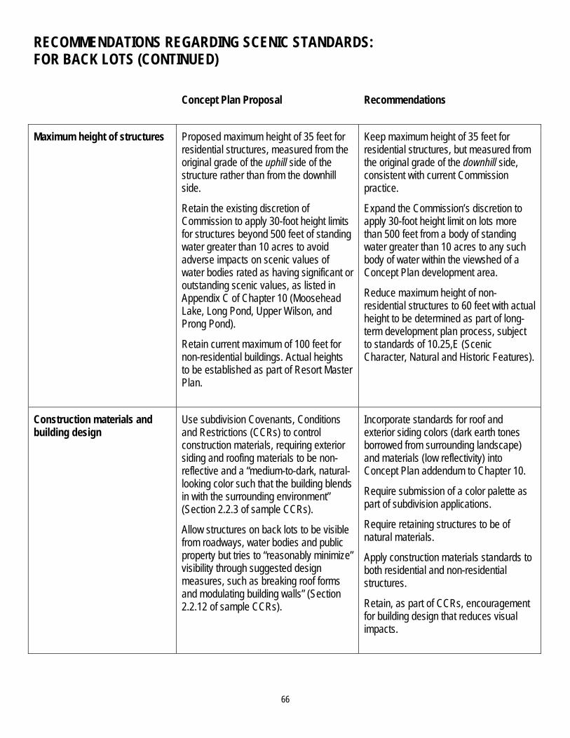
66
RECOMMENDATIONS REGARDING SCENIC STANDARDS: FOR BACK LOTS (CONTINUED)
Concept Plan Proposal Recommendations
Maximum height of structures Proposed maximum height of 35 feet for residential structures, measured from the original grade of the uphill side of the structure rather than from the downhill side.
Retain the existing discretion of Commission to apply 30-foot height limits for structures beyond 500 feet of standing water greater than 10 acres to avoid adverse impacts on scenic values of water bodies rated as having significant or outstanding scenic values, as listed in Appendix C of Chapter 10 (Moosehead Lake, Long Pond, Upper Wilson, and Prong Pond).
Retain current maximum of 100 feet for non-residential buildings. Actual heights to be established as part of Resort Master Plan.
Keep maximum height of 35 feet for residential structures, but measured from the original grade of the downhill side, consistent with current Commission practice.
Expand the Commission’s discretion to apply 30-foot height limit on lots more than 500 feet from a body of standing water greater than 10 acres to any such body of water within the viewshed of a Concept Plan development area.
Reduce maximum height of non-residential structures to 60 feet with actual height to be determined as part of long-term development plan process, subject to standards of 10.25,E (Scenic Character, Natural and Historic Features).
Construction materials and building design
Use subdivision Covenants, Conditions and Restrictions (CCRs) to control construction materials, requiring exterior siding and roofing materials to be non-reflective and a “medium-to-dark, natural-looking color such that the building blends in with the surrounding environment” (Section 2.2.3 of sample CCRs).
Allow structures on back lots to be visible from roadways, water bodies and public property but tries to “reasonably minimize” visibility through suggested design measures, such as breaking roof forms and modulating building walls” (Section 2.2.12 of sample CCRs).
Incorporate standards for roof and exterior siding colors (dark earth tones borrowed from surrounding landscape) and materials (low reflectivity) into Concept Plan addendum to Chapter 10.
Require submission of a color palette as part of subdivision applications.
Require retaining structures to be of natural materials.
Apply construction materials standards to both residential and non-residential structures.
Retain, as part of CCRs, encouragement for building design that reduces visual impacts.
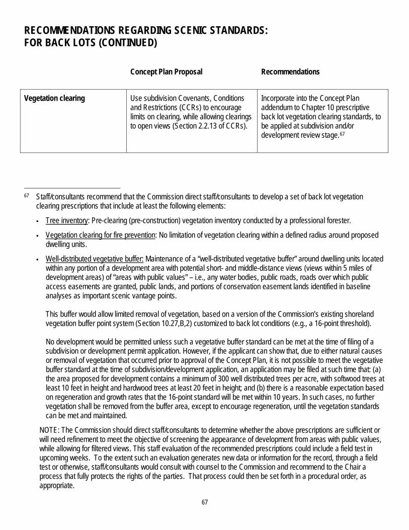
67
RECOMMENDATIONS REGARDING SCENIC STANDARDS: FOR BACK LOTS (CONTINUED)
Concept Plan Proposal Recommendations
Vegetation clearing Use subdivision Covenants, Conditions and Restrictions (CCRs) to encourage limits on clearing, while allowing clearings to open views (Section 2.2.13 of CCRs).
Incorporate into the Concept Plan addendum to Chapter 10 prescriptive back lot vegetation clearing standards, to be applied at subdivision and/or development review stage.67
67 Staff/consultants recommend that the Commission direct staff/consultants to develop a set of back lot vegetation
clearing prescriptions that include at least the following elements:
Tree inventory: Pre-clearing (pre-construction) vegetation inventory conducted by a professional forester.
Vegetation clearing for fire prevention: No limitation of vegetation clearing within a defined radius around proposed dwelling units.
Well-distributed vegetative buffer: Maintenance of a “well-distributed vegetative buffer” around dwelling units located within any portion of a development area with potential short- and middle-distance views (views within 5 miles of development areas) of “areas with public values” – i.e., any water bodies, public roads, roads over which public access easements are granted, public lands, and portions of conservation easement lands identified in baseline analyses as important scenic vantage points. This buffer would allow limited removal of vegetation, based on a version of the Commission’s existing shoreland vegetation buffer point system (Section 10.27,B,2) customized to back lot conditions (e.g., a 16-point threshold). No development would be permitted unless such a vegetative buffer standard can be met at the time of filing of a subdivision or development permit application. However, if the applicant can show that, due to either natural causes or removal of vegetation that occurred prior to approval of the Concept Plan, it is not possible to meet the vegetative buffer standard at the time of subdivision/development application, an application may be filed at such time that: (a) the area proposed for development contains a minimum of 300 well distributed trees per acre, with softwood trees at least 10 feet in height and hardwood trees at least 20 feet in height; and (b) there is a reasonable expectation based on regeneration and growth rates that the 16-point standard will be met within 10 years. In such cases, no further vegetation shall be removed from the buffer area, except to encourage regeneration, until the vegetation standards can be met and maintained.
NOTE: The Commission should direct staff/consultants to determine whether the above prescriptions are sufficient or will need refinement to meet the objective of screening the appearance of development from areas with public values, while allowing for filtered views. This staff evaluation of the recommended prescriptions could include a field test in upcoming weeks. To the extent such an evaluation generates new data or information for the record, through a field test or otherwise, staff/consultants would consult with counsel to the Commission and recommend to the Chair a process that fully protects the rights of the parties. That process could then be set forth in a procedural order, as appropriate.

68
RECOMMENDATIONS REGARDING SCENIC STANDARDS: FOR BACK LOTS (CONTINUED)
Concept Plan Proposal Recommendations
Vegetation clearing (continued) Provide for potential modification of the vegetation clearing standard under certain circumstances documented as part of a long-term development plan.68
Lily Bay Mountain and Indian Pond Shore Low Impact Zones
Subject to same scenic standards as other zones.
Indian Pond Shore Primitive Resort Development Zone: Adhere to existing shoreland vegetation clearing standards.
Lily Bay Mountain Primitive Resort Development Zone: Impose a “no visibility” standard – i.e., the development may not be visible from “areas with public values.”
Note recommendations to separate these areas into a Primitive Resort Development Zone – see recommendations, Land Use Zones (Permitted Uses).
Ridgeline protection Retains the existing standard (Section 10.25,E,1,c) that preserves the natural character of ridgelines.
No recommended changes.
68 Such modifications could apply to:
(a) Non-residential structures that are part of a long-term development plan, if the applicant can show that (1) the standard is not practicable when applied to non-residential uses, and (2) the location, design, landscaping, and other measures proposed will satisfy the Commission’s general scenic impact standards (Section 10.25,E); and
(b) Either residential or non-residential structures if, as part of a long-term development plan, the applicant is able to show to the Commission’s satisfaction, based on a comprehensive, area-specific scenic impact assessment, that (1) well-defined parts of the viewshed(s) are already developed or are not sensitive to change and that greater protection will be focused on more sensitive parts of the viewshed(s); or (2) topographic and other natural conditions or the layout of the development create buffering conditions as effective as lot-by-lot vegetative screening; and (3) that in any case the totality of measures will provide for an equal or greater level of protection of scenic values.

69
RECOMMENDATIONS REGARDING SCENIC STANDARDS: FOR BACK LOTS (CONTINUED)
Concept Plan Proposal Recommendations
Placement of roads, driveways, and utility corridors
Does not explicitly address. Include as part of the addendum to Chapter 10, in Section 10.25,E, a requirement that roads, driveways, utility corridors, trails and other linear elements will not be placed so as to circumvent the intent of the scenic impact standards.
RECOMMENDATIONS REGARDING LIGHTING AND NOISE STANDARDS
Concept Plan Proposal Recommendations
Lighting Retains existing lighting standards (Section 10.25,F,2) and adds more detailed standards for exterior lighting on residential lots; in sample CCRs, prohibits spot lights.
No recommended changes.
Noise Modifies existing noise standards (Section 10.25,F,1) by relaxing the noise standard for protection zones located entirely within development zones, and by exempting sounds emanating from motorized vehicles and even-related activities such as concerts and fireworks.
Delete the changes to existing noise standards.
70
MAINE DEPARTMENT OF TRANSPORTATION TRAFFIC MOVEMENT PERMIT
On March 6, 2008 Plum Creek requested leave of the Commission Chair to submit into the record the Maine Department of Transportation’s (“MDOT”) final Traffic Movement Permit for the Concept Plan. No party responded to this request, which the Chair granted in the Twelfth Procedural Order.
On May 8, 2008, Maine Audubon/Natural Resources Council of Maine (“MA/NRCM”) submitted comments on the MDOT permit and its relevance to the Commission’s review criteria. MA/NRCM asserts that the permit is “neither relevant nor conclusive on any of the issues” before the Commission in this proceeding, including especially impacts to wildlife and wildlife habitat, because MDOT did not purport to analyze or address these issues in its permit.
71
RECOMMENDATIONS REGARDING CONSIDERATION OF THE MDOT TRAFFIC MOVEMENT PERMIT
The Traffic Movement Permit addresses those issues uniquely within MDOT’s jurisdiction, namely traffic safety and congestion. On those issues, staff/consultants recommend that Commission should consider the Permit to be dispositive. MDOT did not address or purport to address the Concept Plan’s potential impacts to wildlife, wildlife habitat or recreation in the Permit, which are issues within the Commission’s jurisdiction. To the extent that the Traffic Movement Permit may include conditions that the Commission finds incidentally relevant to issues within its jurisdiction, the Commission should take those conditions into account as binding obligations on Plum Creek. For example, where the Permit addresses road maintenance though illumination, shoulder widening and signage, the Commission should take notice of these requirements for whatever potential relevance they may have to its review criteria. However, the Commission should not consider the mere issuance of the Permit to have resolved any issues within the Commission’s jurisdiction, and must conduct its own independent review and enter its own findings on all such issues.
While MDOT’s Traffic Movement Permit is concerned with safe traffic movement and did not purport to address the Concept Plan’s potential impacts to recreation, its permit conditions concerning pedestrian and bicycle accommodations overlap the Commission’s concerns for recreation. Specifically, MDOT requires that:
Each dwelling unit or resort accommodation unit within any subdivision shall make bicycle/pedestrian accommodations for use by the owners of the subdivision, either on the subdivision roadway or via a path;
If a subdivision is within a half-mile of an established activity center in Rockwood, with commercial or public services or of a D-GN3M subdistrict, as identified in the applicant’s Concept Plan, the accommodation on the subdivision road or path shall also connect to the center or district;
Upon the first 200 peak hour trips as a result of the Concept Plan, the applicant shall pay the Town of Greenville a one-time $40,000 fee to work with a consultant to design and implement bicycle and pedestrian facilities in the downtown area; and
Once a Master Plan is approved for Lily Bay resort, the applicant must provide a bicycle/pedestrian connection from the Greenville/Beaver Cover Town Line to Lily Bay State Park and from Lily Bay State Park to Lily Bay resort (via roadways, abandoned or current woods roads, and/or single track type trail).
Staff/consultants acknowledge that these requirements, while aimed at safe traffic movement, will enhance recreational opportunities as well. Staff/consultants recommend that, if the Commission approves a Concept Plan, the applicant be required to petition MDOT to amend the permit to assure that the language of the permit aligns with the approved terms of the Concept Plan (for example, references to Master Plans, the D-GN3M zone and to certain driveways such as Driveway 22 could become obsolete if the Commission accepts certain recommendations).

72
OFFSET CONSERVATION: BALANCE CONSERVATION EASEMENT
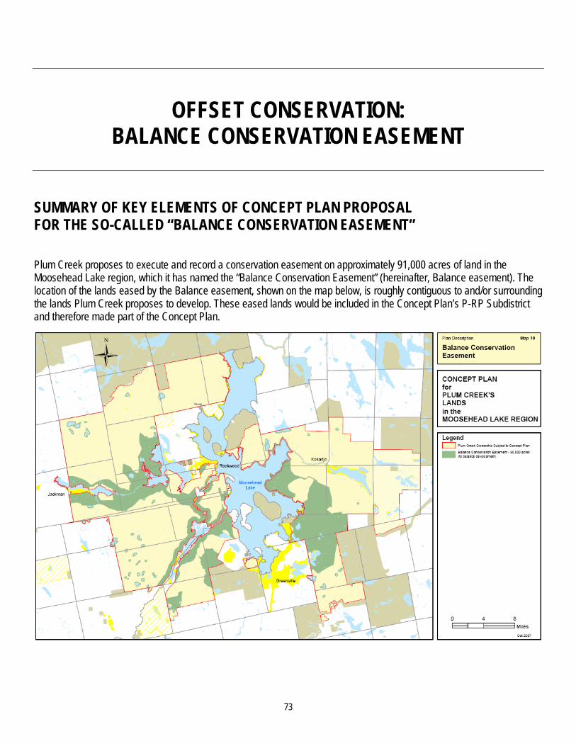
OFFSET CONSERVATION: BALANCE CONSERVATION EASEMENT
SUMMARY OF KEY ELEMENTS OF CONCEPT PLAN PROPOSAL FOR THE SO-CALLED “BALANCE CONSERVATION EASEMENT” Plum Creek proposes to execute and record a conservation easement on approximately 91,000 acres of land in the Moosehead Lake region, which it has named the “Balance Conservation Easement” (hereinafter, Balance easement). The location of the lands eased by the Balance easement, shown on the map below, is roughly contiguous to and/or surrounding the lands Plum Creek proposes to develop. These eased lands would be included in the Concept Plan’s P-RP Subdistrict and therefore made part of the Concept Plan.
73

74
The Forest Society of Maine (FSM) is proposed as the holder of the easement; the Maine Bureau of Parks and Lands (BPL) is proposed as the third-party backup holder. The easement would be executed upon Commission approval of the Concept Plan.
The text of the proposed easement has undergone several amendments, with the current proposed text submitted to the Commission on October 27, 2007. Since that submission, both FSM and The Nature Conservancy (TNC) have proposed additional, identical amendments to the text of both the Balance easement and the Legacy easement, in response to testimony provided to the Commission by governmental agencies and intervenors.69
RECOMMENDATIONS REGARDING BALANCE EASEMENT: OVERVIEW
Staff/consultants believe that the terms of the Balance easement and the Legacy easement should be essentially identical, and that the Holder of each easement should be the same party. These terms are more fully described in the following table. The Balance and Legacy easements, if effectuated, would in combination apply to more land area than does any existing easement in Maine and most any existing easement in the United States.
The actual language used in these easements and their accompanying documents, and how this language is subsequently interpreted, will play a critical role in determining, over time, whether these easements accomplish the mitigation and other regulatory purposes for which they are being proposed by the petitioner and potentially accepted by the Commission. Because this language will last “in perpetuity” and likely will be complicated if not near-impossible to amend, it is essential that it be very carefully scrutinized now to ensure that the Commission fully understands its meaning and implications, and that the language itself be as internally consistent and free of interpretive complexities as possible.
In the specific recommendations that follow, staff/consultants have proposed changes to a number of terms in the easement and the documents appended thereto. (These recommendations apply to both the Balance and the Legacy easements, but for conciseness the listing of recommendations is presented to the Commission just once, in this Balance easement document.) Some of these recommendations are very specific (such as changing the number of subdivisions allowed); others are necessarily broader (such as eliminating many paragraphs in the proposed “Multi-Purpose Management Plan” and otherwise ensuring that this appended document focuses on providing a complete list of required forest management programs and practices set forth with sufficient specificity to be enforceable). The implementing language for the recommendations adopted by the Commission will need to be carefully drafted subsequent to the deliberative sessions and once the Commission’s governing intent is understood by staff/consultants and legal counsel.
While a number of specific recommendations are made below, staff/consultants as well as legal counsel to the Commission believe that additional specific recommendations may emerge as further review occurs. For instance, based on both record evidence and their own review of the easements, staff/consultants as well as legal counsel to the Commission have noted a number of provisions of these easements in which the meaning, consistency or implications of language used (or excluded) appear unclear and require further evaluation before a determination can be made whether a specific recommendation to the Commission is appropriate. As such, the last specific recommendation listed below is for the Commission to direct staff/consultants and legal counsel to Commission to undertake a thorough review of all text of the Balance and Legacy Easements and make any further recommended language changes to the Commission as a result of this review.70
69 See, e.g., Opening Post Hearing Brief of The Nature Conservancy, March 7, 2008 at pp 2-4; Post Hearing Brief of the
Forest Society of Maine, March 7, 2008 at p 1. 70 All language changes resulting from Commission adoption of recommendations below (or changes thereto) would be
presented by staff/consultants and legal counsel to the Commission as part of the Commission’s review of final language of any proposed amended Concept Plan. A Commission decision on this proposed final language will then be subject to notice and comment by all parties.

75
RECOMMENDATIONS REGARDING BALANCE EASEMENT: LOCATION, AMOUNT OF LAND, AND ZONING
Concept Plan Proposal Recommendations
Location, size of easement 91,000 +/- acres in Moosehead Lake region, as shown on accompanying map, above.
Other than the additions listed below, no further additions of land to Balance easement required, as long as all recommendations regarding the Legacy easement and Roaches property are adopted by the Commission.71
Add limited acreage to Balance easement due to recommendations to:
1. Eliminate two Long Pond north shore development zones;
2. Scale down Lily Bay development acreage;
3. Protect certain large significant wildlife habitat areas identified by IFW/MNAP that adjoin the Balance easement lands; and
4. Remove proposed M-GNM zones from Rockwood/Blue Ridge and Big Moose Mountain development areas.
Inclusion in P-RP Subdistrict Included in rezoning to P-RP Subdistrict, therefore part of Concept Plan boundary.
No recommended changes.
71 Staff/consultants are not recommending the Commission adopt IFW/MNAP’s request to remove from the Balance
and/or the Legacy easement certain lands these agencies deem to be particularly ecologically valuable, and instead require their donation, in fee, to the State. Staff/consultants’ recommendation is to achieve added protection of these lands through language changes in the Balance and Legacy easements that: (1) require these lands be identified in the Baseline documentation and then on an ongoing basis; (2) receive special management protection, in terms of limits on forest management and harvesting practices; and (3) that the nature of this special management protection be set forth in detail in language in the accompanying Management Plan, and reviewed and approved by the Commission as part of its review of final language of any proposed amended Concept Plan.

76
RECOMMENDATIONS REGARDING BALANCE EASEMENT: LOCATION, AMOUNT OF LAND, AND ZONING (CONTINUED)
Concept Plan Proposal Recommendations
Land use zoning Except for land otherwise zoned as a Protection Subdistrict, both the Balance and Legacy easement lands are proposed to be zoned M-GNM. The Concept Plan incorporates by reference the Commission’s General Management (M-GN) subdistrict, as amended from time to time, with certain provisions (e.g. no residential development) fixed for 30 years.72
Concept Plan specific General Management (M-GNM) zone, as modified by recommendations for permitted uses.73
72 See recommendations, Land Use Zoning (Permitted Uses). 73 Ibid.

77
RECOMMENDATIONS REGARDING BALANCE EASEMENT: HOLDER AND THIRD-PARTY BACKUP HOLDER
Concept Plan Proposal Recommendations
Holder of easement Forest Society of Maine. Holder of the Balance easement and the Legacy easement should be the same entity.74
Making the Holder a State of Maine agency, preferably DOC’s Bureau of Parks and Lands, is consistent with the purpose of creating the easement, and its very large scale.75 However, the Commission could determine that a private organization (e.g., FSM) could be the Holder (based upon the organization’s mission and focus), so long as the private organization is capable of monitoring and enforcing the easement, and a meaningful mechanism for making a private Holder publicly accountable in perpetuity could be developed.76
74 Testimony from TNC states that TNC intends to transfer its Legacy easement holder status to BPL, based upon TNC’s
desire to receive funds from the federal Forest Legacy program in compensation for purchasing the easement and TNC’s understanding that receipt of these funds depends upon a federal or state agency being the holder of the easement. There is no record evidence to date regarding whether FSM or another non-governmental entity would or would not qualify as the Holder under the Forest Legacy program if a state agency (such as BPL) is a third-party holder and possesses significant residual monitoring and enforcement rights.
75 The easement terms proposed by Plum Creek as well as the changes thereto recommended by staff/consultants grant substantial authority and autonomy to the Holder to make decisions that significantly affect the public rights and protections that are granted through the easement. These public rights and protections are being granted by the landowner in exchange for LURC granting certain extraordinary development rights to the landowner. Given this, the issue is whether in this particular situation – a landscape-scale easement resulting from a regulatory process -- only a public entity (and not a private organization) should be responsible for ensuring that these public values and protections are achieved.
76 Should the Commission wish to allow FSM or another private organization to be the easement Holder, staff/consultants recommend that new easement language must be developed and presented to the Commission that provides ongoing third-party BPL oversight of the Holder’s work (e.g., possibly similar to BPL’s oversight of its contractors now doing easement monitoring), and enables BPL to replace the Holder if BPL determines that the Holder is not adequately performing. Whether such language would be an effective means of providing long-term public accountability on a large-scale easement has not been tested in Maine, to the best of the staff/consultant’s knowledge.

78
RECOMMENDATIONS REGARDING BALANCE EASEMENT: HOLDER AND THIRD-PARTY BACKUP HOLDER (CONTINUED)
Concept Plan Proposal Recommendations
Third-party backup holder Bureau of Parks and Lands. Third-party backup holder of the Balance easement and the Legacy easement should be the same entity.
Ensure third-party backup holder has rights consistent with those granted to the Holder.
RECOMMENDATIONS REGARDING BALANCE EASEMENT: TIMING OF CONVEYANCE OF BALANCE EASEMENT, RELATIONSHIP TO DEVELOPMENT
Concept Plan Proposal Recommendations
When is Balance easement conveyed to Holder?
Upon Commission approval of the Concept Plan.
Upon an approved Concept Plan becoming final (Concept Plan approval no longer subject to appeal).
Ability of subdivision and other development permitting to go forward prior to Concept Plan becoming final
Not addressed. If the Commission is not presented with evidence that the Balance easement has been conveyed and recorded within 45 days of finalization of the Concept Plan, it will cease processing all Concept Plan development-related applications until this evidence has been presented.

79
RECOMMENDATIONS REGARDING BALANCE EASEMENT: RELATIONSHIP OF BALANCE EASEMENT TERMS TO LEGACY EASEMENT TERMS
Concept Plan Proposal Recommendations
Consistency of Balance easement terms with Legacy easement terms
Some inconsistencies exist; however, Plum Creek has stated its desire and intent that all terms of the Balance and Legacy easements be consistent.
Direct staff/consultants to:
1. Ensure that Plum Creek’s desire and intent for consistency is achieved in both easements, except where minor differences between the two easements may be appropriate (e.g., allowance for different amounts of gravel extraction in the two easements to account for different acreage amounts of the easements); and
2. Report back to the Commission with specific language changes, if any, to achieve this intent.

80
RECOMMENDATIONS REGARDING BALANCE EASEMENT: FUNDING FOR EASEMENT MONITORING AND ENFORCEMENT
Concept Plan Proposal Recommendations
Funding for easement monitoring, “stewardship”, and enforcement of terms
By an undated letter provided to the Commission and accepted into the record on January 22, 2008, Plum Creek stated its intent to “memorialize the agreement reached between Plum Creek and the Forest Society of Maine” regarding “the creation of a stewardship endowment for the Balance Easement”.77
A single monitoring, stewardship and enforcement fund should be created for both the Balance and Legacy easements, consistent with a single Holder for both easements. Direct Plum Creek, the Holder of each easement (as determined by the Commission), and the third-party backup holder of each easement (also as determined by the Commission) to propose to the Commission (either through separate filings or, if possible, through mutual agreement) the financial, fiduciary and administrative terms and conditions that would govern creation, endowment and administration of a single monitoring, stewardship and enforcement fund (hereinafter “fund”) for both the Balance and the Legacy easements. These proposed terms and conditions must be sufficient to ensure that, in perpetuity, proper monitoring, enforcement and stewardship can be fully accomplished on an ongoing basis. The Commission should allow the parties a reasonable opportunity to comment on these filings.
77 Key terms of this agreement are:
“a contribution of $750,000 to endow an easement stewardship fund”; a “one time $30,000 contribution to FSM to cover FSM’s first year start up costs”; an annual contribution “by Plum Creek or successor(s)” of $5,000 per year increased by cost of living index “to
address increased needs anticipated if third-party certification were to be discontinued”; an annual $5,000 contribution increased by cost of living index, made by separate owners “for each separate
ownership not under third-party certification” if the easement lands have been divided. Funds are held and disbursed by the Maine Community Foundation. Funds will go to new Holder if FSM is no longer Holder.

81
RECOMMENDATIONS REGARDING BALANCE EASEMENT: FUNDING FOR EASEMENT MONITORING AND ENFORCEMENT (CONTINUED)
Concept Plan Proposal Recommendations
Timing of creating, endowing the Fund
Upon grant of easement. Plum Creek must demonstrate that this approved fund has been established, endowed and is in operation simultaneous to Plum Creek’s demonstration that the Balance and Legacy conservation easements are in effect and have been duly recorded.
RECOMMENDATIONS REGARDING BALANCE EASEMENT: TERMS GOVERNING ALLOWED ACTIVITIES
Concept Plan Proposal Recommendations
Purpose of easement Language includes both conservation purposes and the purpose of allowing “continued operation as a working forest with the perpetual ability to commercially produce forest products”.
Clarify and conform “Purpose”, “Whereas” clauses, and language in other sections of easement78 so that, when read together and in comparison with other easement language, these sections cannot be interpreted as subordinating or eliminating protection of conservation values when in conflict with Forest Management Activities.
78 See, e.g., section 1, paragraph 2, introductory clause.

82
RECOMMENDATIONS REGARDING BALANCE EASEMENT: TERMS GOVERNING ALLOWED ACTIVITIES (CONTINUED)
Concept Plan Proposal Recommendations
General land uses, excluding forest management activities
1. Construction material removal (“quarrying or otherwise” and “storage” of “rock, gravel, aggregate, sand other similar construction materials”)
Allowed for forest management activities, road maintenance, supplying to “development of areas zoned for development in the vicinity” of the easement. Siting of these activities made by landowner “in consultation with Holder."
Limit removal allowed for development activities (short term and total) to only that needed for nearby communities (which would be mapped and attached to easement).
Require sufficient Holder notice for pre-removal; for any proposed removal that Holder believes would adversely impact conservation values, require Landowner showing to Holder of no reasonable alternative location for obtaining needed materials.
2. Septic fields
Permitted up to 100 acres at any time; no cap; landowner must “minimize impact on the conservation values”; holder approval of siting required.
Limit spreading to only acreage needed (short term and total allowed) to serve nearby communities (which would be mapped and attached to easement).
3. Mining activities Allowed if mineral rights exist at time of grant of easement; Plum Creek contends its title searches have produced no evidence of existing rights.
Mining activities should not occur. Require Plum Creek to insure that no pre-existing rights exist or insure that any claim of a pre-existing right will not result in any mining activity occurring (i.e., Commission should shift liability to Plum Creek, rather than the public assuming the risk of amine being developed due to incomplete title search, etc.).
4. Wind power Allows structures and improvements (e.g., transmission lines) needed to allow wind generation; Legacy easement allows turbine siting.
Allow only if Holder determines that such structures and improvements will not adversely impact conservation values of easements.

83
RECOMMENDATIONS REGARDING BALANCE EASEMENT: TERMS GOVERNING ALLOWED ACTIVITIES (CONTINUED)
Concept Plan Proposal Recommendations
General land uses, excluding forest management activities (continued)
5. Water extraction
Permitted but not for commercial or “bottled water purposes.”
Limit activity to only that needed by nearby community (which would be mapped and attached to easement).
Require sufficient Holder notice prior to planned extraction; for any proposed extraction that Holder believes would adversely impact conservation values, require Landowner showing to Holder of no reasonable alternative location for obtaining needed water.
6. Campgrounds Prohibited.
Allow so long as size is limited, locations are determined by BPL, and campgrounds are operated by BPL or its agent.
7. Permitted easement rights for all lawful purposes (e.g., roads for wind activities and for gravel extraction)
Grantor has full authority to grant such rights. Holder has only notice and comment rights on decision to grant easements.
Require same level of Holder review and approval of grant of easement rights as required for specific permitted activity for which easement is needed; remove language waiving consideration of conservation values.
Grant rights to BPL for trail building, hut building, campgrounds and other related activities.

84
RECOMMENDATIONS REGARDING BALANCE EASEMENT: TERMS GOVERNING ALLOWED ACTIVITIES (CONTINUED)
Concept Plan Proposal Recommendations
General land uses, excluding forest management activities (continued)
8. Subdivisions / “parcelization” of easement lands
Up to 5 subdivisions of no less than 5,000 acres per subdivision; 2 in 5 subdivision lot creation eliminated.
Allowed to gift or sell “no more than 50 acres...in the aggregate to a governmental or quasi-governmental entity...”
For the Balance and Legacy easements combined, limit to no more than 5 to 10 subdivisions (Commission to decide exact number) of no less than 5,000 acres; subdivision boundaries can cross over the boundaries of the two easements.79
Limit significantly the size of any one parcel making up part of 50 acres; allow gift or sale only upon finding by the Holder that the legally-stipulated use of the acreage will not adversely impact conservation values of easement and is located near development areas.
Ensure appropriate acreage granted to BPL for public campgrounds and campsites.
79 Staff/consultants recommend that the Commission significantly reduce the combined total of twenty-five (25)
subdivisions allowed by the Balance and Legacy easements. Staff/consultants contend that it is untenable for any easement Holder to effectively monitor easement performance of 25 separate property owners. In addition, legally permitting up to 25 subdivisions of this 357,000 +/- acres (Balance and Legacy combined) means that the easement lands, over time, could involve separately-owned 15,000 acre parcels, making consistent, cross-boundary landscape-scale management for wildlife and recreation very challenging if not impossible. Allowing a total of five subdivisions of no less than 5,000 acres, and therefore the prospect of the Holder monitoring the activities of five different owners of sizeable parcels (even if some of these parcels were closer to the minimum permitted 5,000 acres) appears to staff/consultants to be both quite manageable and preserving of the ability to manage at a landscape scale. Allowing the staff/consultant-proposed upper limit of ten subdivisions appears to also preserve the ability for landscape-scale management, although the ability of a Holder to monitor the activities of ten separate landowners is somewhat less clear, and likely dependent on the nature of the landowner and the activities performed on those ten separate tracts (for example, ten owners performing timber harvesting operations of varying quality and approach could present different demands than ten owners, five of whom were conducting timber harvesting operations and five of whom were conducting minimum harvesting operations).

85
RECOMMENDATIONS REGARDING BALANCE EASEMENT: TERMS GOVERNING ALLOWED ACTIVITIES (CONTINUED)
Concept Plan Proposal Recommendations
Structures and improvements Structures and improvements allowed for permitted activities such as forestry, wind power, septic fields, construction material removal, trails, nature observation, etc. Grantor has full authority to grant.
Direct staff/consultants and legal counsel to carefully review the open-ended nature of this language and, if required, make recommendations to the Commission to ensure that significant commercial and industrial structures (e.g., sawmills) are prohibited, and to develop limits on proliferation of structures and improvements and resulting compromise of conservation values.
Holder has notice and comment rights only on decision to grant easements. Includes “roads, utilities, and telecommunication facilities (two cell towers in the Balance easement) and/or public fire and safety buildings...”
Require the same level of Holder review and approval of structures and improvements as required for specific permitted activity for which structure/ improvement is needed.
Public boat launches allowed.
Allow public boat launches only if Holder determines that boat launches will not adversely impact conservation values of easements.
Backcountry huts (up to 5,000 sq. feet/40 ft. height limit; up to three in the Balance easement) allowed if non-profit operation, open to public, and used by persons engaged in primitive recreation.
Consistent with protecting conservation values, Holder and landowner shall determine the appropriate maximum number and size of huts in the Balance and Legacy easements, combined.

86
RECOMMENDATIONS REGARDING BALANCE EASEMENT: TERMS GOVERNING ALLOWED ACTIVITIES (CONTINUED)
Concept Plan Proposal Recommendations
Forest management activities
1. Definition of allowed activities Broadly written; “include but not be limited to”; “any similar activity Grantor deems useful or expedient in connection with foregoing..."
Direct staff/consultants and legal counsel to carefully review the open-ended nature of this language and, if required, make recommendations to the Commission to ensure that this language is not overly broad, in comparison to similar easements that permit forest management activities.
2. Management Advisory Team (MAT)
Intended to advise landowner and Holder on appropriate forest management activities.
Structure MAT so that IFW is responsible for its operations and functioning.
Remove Plum Creek (and all subsequent landowners) from membership on MAT.
Redraft language to make clear that MAT has the authority to provide ongoing written advice to Holder and to landowner(s) on outcomes and proposed changes in forest management activities, as well as advise audit team and Holder during any forest certification process.
Require timely written response from landowner(s), Holder, and forest certification audit team to all such MAT written advice.
Require all MAT and response documents to be public.
Provide opportunity for MAT input to Holder on certain significant proposed non-forestry landowner activities and structures for which Holder review is either allowed or required.

87
RECOMMENDATIONS REGARDING BALANCE EASEMENT: TERMS GOVERNING ALLOWED ACTIVITIES (CONTINUED)
Concept Plan Proposal Recommendations
Forest management activities (continued)
3. Qualifying certification programs
Three “Qualifying Forest Certification Program[s]” predetermined as qualifying in perpetuity; Holder has ability to add additional certification programs. Landowner chooses which program to use, and may choose to not be certified.
Establish right of Holder to remove pre-qualified program, based on demonstration of inadequacy of audit standards or procedures.
Eliminate American Tree Farm System certification program as pre-qualified in easement.
Alternative certification approach:
Adopt LMF model easement language, in which Holder is given ongoing authority to independently approve an independent, third-party certification agent.80
80 This alternative language is contained in LMF Policies for Working Forest Easements, p15, and was submitted to the
Commission as an attachment to comments filed by the State Planning Office (Tim Glidden) on November 20, 2007.

88
RECOMMENDATIONS REGARDING BALANCE EASEMENT: TERMS GOVERNING ALLOWED ACTIVITIES (CONTINUED)
Concept Plan Proposal Recommendations
Forest management activities (continued)
4. Impact of third-party certification Creates very high presumption of compliance by landowner with forest management activities required by easement.81 Holder must take disagreements through a multi-step process, including the certification appeals process, before taking action.
Amend language so that certification shall be evidence, but not near-unchangeable conclusion, that landowner is in compliance with forestry principles and management plan.82
Decouple Holder enforcement timing from certification appeals process conclusion or set time limit on waiting on appeals process.
Alternative approach to weighing certification findings: Adopt LMF model easement language, in which certification from Holder-selected certifying program given stated weight and authority.
Availability to public of audit results not stated.
Summary of audit results must be provided to the MAT by the auditors in a timely manner.
No stated requirement that audit include review of compliance with Forestry Principles and Management Plan.
Require audit to address these issues.
81 This language is found in the Balance easement, section 5.D.(ii). 82 Staff/consultants believe the current language of the easement in section 5.D.(ii) compels the finding that the landowner
is “in full compliance with the Forestry Principles and the Management Plan” so long as certification is granted regardless of whether an audit has, for instance, identified significant nonconformities by the landowner in its implementation of one particular aspect of its Management Plan. In this situation, Plum Creek’s proposed language essentially removes any ability of the Holder to either attempt to stop continuation of such practices or to take enforcement action.

89
RECOMMENDATIONS REGARDING BALANCE EASEMENT: TERMS GOVERNING ALLOWED ACTIVITIES (CONTINUED)
Concept Plan Proposal Recommendations
Forest management activities (continued)
5. Multi-Resource Management Plan
Attached to easement and incorporated by reference; all forest management activities to be conducted consistent with it.
Eliminate language that is: (a) written for purposes of federal Forest Legacy funding requirements; (b) inconsistent with or needlessly repetitious of language in the easement; (c) irrelevant to purpose of document; and/or (d) prejudicial to ability of Holder and third-party to enforce easement.
Remove language on Management Advisory Team structure and role; place MAT provisions in easement.
Direct staff/consultants to determine whether stated “programs and practices” contained in Management Plan are complete listing of programs and practices necessary to ensure conservation values are achieved (particularly wildlife values), and whether the programs and practices contain standards of conduct that can be measured and enforced, and make appropriate recommendations to the Commission.
6. Documents attached to Management Plan (entitled “Plum Creek Maine and New Hampshire Environmental Action Plan” and “Maine Forest Products Council Conservation Strategy for the Canada Lynx in Maine”)
These two documents (50+/- pages) contain a range of information regarding, inter alia, internal Plum Creek’s current forest practices, its goals, history, and a general description of forest condition.
Eliminate documents as attachments and direct staff/consultants to recommend to the Commission whether to incorporate discrete, relevant portions into easement or management plan as enforceable terms and conditions.
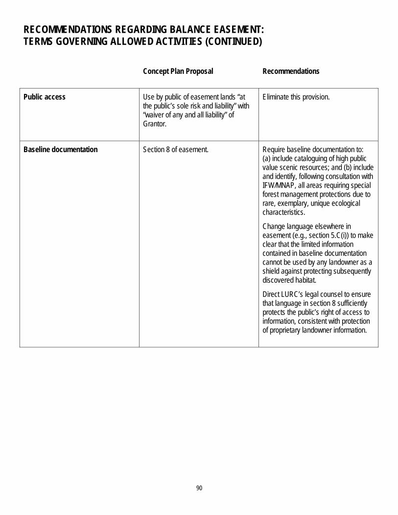
90
RECOMMENDATIONS REGARDING BALANCE EASEMENT: TERMS GOVERNING ALLOWED ACTIVITIES (CONTINUED)
Concept Plan Proposal Recommendations
Public access Use by public of easement lands “at the public’s sole risk and liability” with “waiver of any and all liability” of Grantor.
Eliminate this provision.
Baseline documentation Section 8 of easement. Require baseline documentation to: (a) include cataloguing of high public value scenic resources; and (b) include and identify, following consultation with IFW/MNAP, all areas requiring special forest management protections due to rare, exemplary, unique ecological characteristics.
Change language elsewhere in easement (e.g., section 5.C(i)) to make clear that the limited information contained in baseline documentation cannot be used by any landowner as a shield against protecting subsequently discovered habitat.
Direct LURC’s legal counsel to ensure that language in section 8 sufficiently protects the public’s right of access to information, consistent with protection of proprietary landowner information.
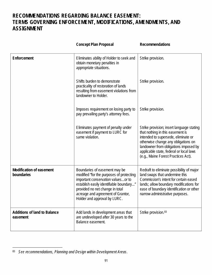
91
RECOMMENDATIONS REGARDING BALANCE EASEMENT: TERMS GOVERNING ENFORCEMENT, MODIFICATIONS, AMENDMENTS, AND ASSIGNMENT
Concept Plan Proposal Recommendations
Enforcement Eliminates ability of Holder to seek and obtain monetary penalties in appropriate situations.
Strike provision.
Shifts burden to demonstrate practicality of restoration of lands resulting from easement violations from landowner to Holder.
Strike provision.
Imposes requirement on losing party to pay prevailing party’s attorney fees.
Strike provision.
Eliminates payment of penalty under easement if payment to LURC for same violation.
Strike provision; insert language stating that nothing in this easement is intended to supersede, eliminate or otherwise change any obligations on landowner from obligations imposed by applicable state, federal or local laws (e.g., Maine Forest Practices Act).
Modification of easement boundaries
Boundaries of easement may be modified “for the purposes of protecting important conservation values...or to establish easily identifiable boundary...” provided no net change in total acreage and agreement of Grantor, Holder and approval by LURC.
Redraft to eliminate possibility of major land swaps that undermine this Commission’s intent for certain eased lands; allow boundary modifications for ease of boundary identification or other narrow administrative purposes.
Additions of land to Balance easement
Add lands in development areas that are undeveloped after 30 years to the Balance easement.
Strike provision.83
83 See recommendations, Planning and Design within Development Areas.

92
RECOMMENDATIONS REGARDING BALANCE EASEMENT: TERMS GOVERNING ENFORCEMENT, MODIFICATIONS, AMENDMENTS, AND ASSIGNMENT (CONTINUED)
Concept Plan Proposal Recommendations
Amendments of easement Holder has broad discretion to accept amendments that involve “uses or proposed improvements not contemplated by or addressed” in easement, and alterations to existing uses or structures, so long as Holder determines amendments are consistent with purpose of easement and does not “materially increase the adverse impact.” LURC must approve amendments.
Direct staff/consultants and legal counsel to Commission to evaluate whether this degree of latitude to amend provisions of easement is appropriate, as well as who should be allowed to approve, and then make subsequent recommendation to LURC.
Assignment of holder rights to another holder
Approval of Grantor required. Strike requirement of Grantor approval.
RECOMMENDATIONS REGARDING BALANCE EASEMENT: ADDITIONAL RECOMMENDATIONS
Concept Plan Proposal Recommendations
Meaning, consistency or implications of language used (or excluded)
Direct staff/consultants and the legal counsel to Commission to undertake a thorough review of all text of the Balance and Legacy Easements and make any recommended language changes to the Commission as a result of this review.

93
CONSERVATION FRAMEWORK
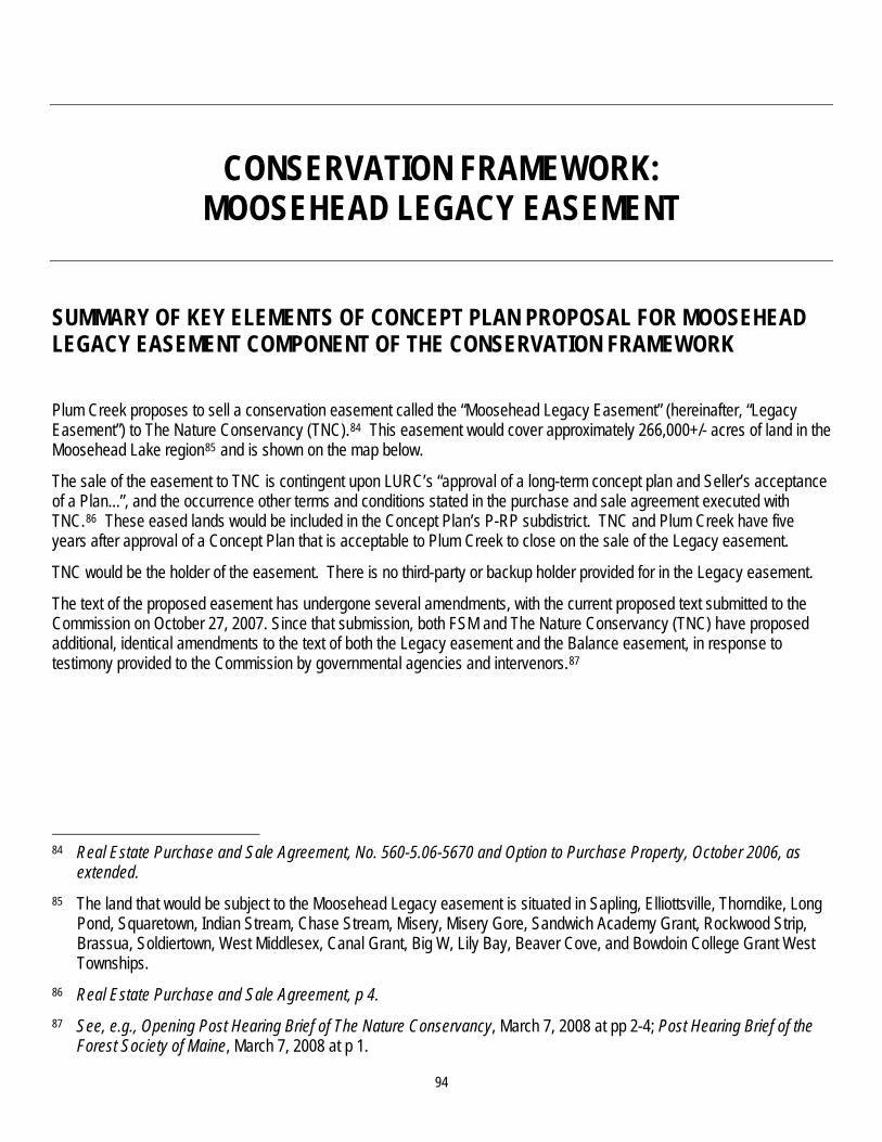
94
CONSERVATION FRAMEWORK: MOOSEHEAD LEGACY EASEMENT
SUMMARY OF KEY ELEMENTS OF CONCEPT PLAN PROPOSAL FOR MOOSEHEAD LEGACY EASEMENT COMPONENT OF THE CONSERVATION FRAMEWORK
Plum Creek proposes to sell a conservation easement called the “Moosehead Legacy Easement” (hereinafter, “Legacy Easement”) to The Nature Conservancy (TNC).84 This easement would cover approximately 266,000+/- acres of land in the Moosehead Lake region85 and is shown on the map below.
The sale of the easement to TNC is contingent upon LURC’s “approval of a long-term concept plan and Seller’s acceptance of a Plan...”, and the occurrence other terms and conditions stated in the purchase and sale agreement executed with TNC.86 These eased lands would be included in the Concept Plan’s P-RP subdistrict. TNC and Plum Creek have five years after approval of a Concept Plan that is acceptable to Plum Creek to close on the sale of the Legacy easement.
TNC would be the holder of the easement. There is no third-party or backup holder provided for in the Legacy easement.
The text of the proposed easement has undergone several amendments, with the current proposed text submitted to the Commission on October 27, 2007. Since that submission, both FSM and The Nature Conservancy (TNC) have proposed additional, identical amendments to the text of both the Legacy easement and the Balance easement, in response to testimony provided to the Commission by governmental agencies and intervenors.87
84 Real Estate Purchase and Sale Agreement, No. 560-5.06-5670 and Option to Purchase Property, October 2006, as
extended. 85 The land that would be subject to the Moosehead Legacy easement is situated in Sapling, Elliottsville, Thorndike, Long
Pond, Squaretown, Indian Stream, Chase Stream, Misery, Misery Gore, Sandwich Academy Grant, Rockwood Strip, Brassua, Soldiertown, West Middlesex, Canal Grant, Big W, Lily Bay, Beaver Cove, and Bowdoin College Grant West Townships.
86 Real Estate Purchase and Sale Agreement, p 4. 87 See, e.g., Opening Post Hearing Brief of The Nature Conservancy, March 7, 2008 at pp 2-4; Post Hearing Brief of the
Forest Society of Maine, March 7, 2008 at p 1.

95

96
RECOMMENDATIONS REGARDING LEGACY EASEMENT: LOCATION, AMOUNT OF LAND, AND ZONING
Concept Plan Proposal Recommendations
Location, size of easement 266,000 +/- acres in Moosehead Lake region, as shown on accompanying map, above.
No recommended changes.88
Inclusion in P-RP Subdistrict Included in rezoning to P-RP subdistrict, therefore part of Concept Plan boundary.
No recommended changes.
Land use zoning Except for land otherwise zoned as a Protection Subdistrict, both the Balance and Legacy easement lands are proposed to be zoned M-GNM. The Concept Plan incorporates by reference the Commission’s General Management (M-GN) subdistrict, as amended from time to time, with certain provisions (e.g. no residential development) fixed for 30-years.89
Concept Plan specific General Management (M-GNM) zone, as modified by staff/consultant recommendations for permitted uses.90
88 As discussed in the recommendations regarding Offset Conservation: Balance Conservation Easement,
staff/consultants are not recommending the Commission adopt IFW/MNAP’s request to remove from the Balance and/or the Legacy easement certain lands these agencies deem to be particularly ecologically valuable, and instead require their donation, in fee, to the State. Staff/consultants’ recommendation is to achieve added protection of these lands through language changes in the Balance and Legacy easements that: (1) require these lands be identified in the Baseline documentation and then on an on-going basis; (2) receive special management protection, in terms of limits on forest management and harvesting practices; and (3) that the nature of this special management protection be set forth in detail in language in the accompanying Management Plan, and reviewed and approved by the Commission as part of its review of final language of any proposed amended Concept Plan.
89 See recommendations, Land Use Zoning (Permitted Uses). 90 Ibid.
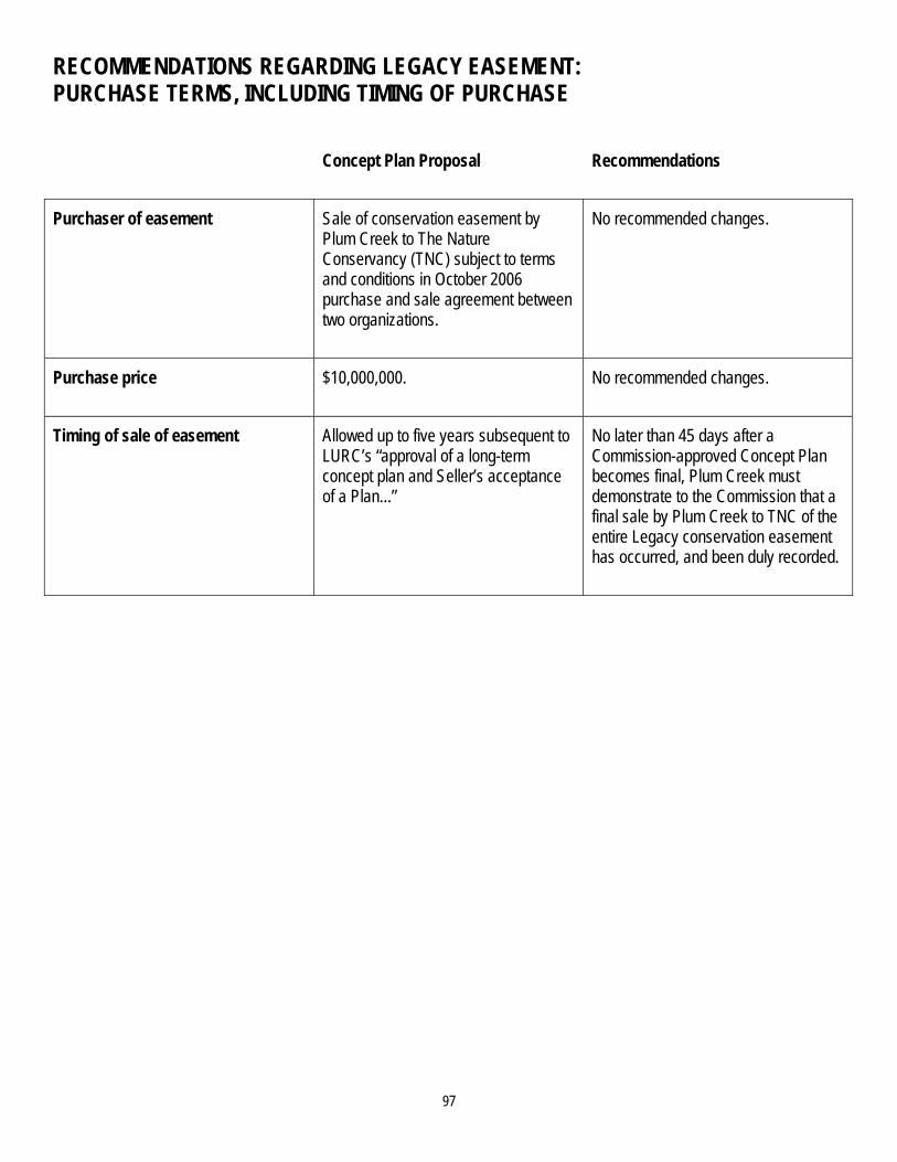
97
RECOMMENDATIONS REGARDING LEGACY EASEMENT: PURCHASE TERMS, INCLUDING TIMING OF PURCHASE
Concept Plan Proposal Recommendations
Purchaser of easement Sale of conservation easement by Plum Creek to The Nature Conservancy (TNC) subject to terms and conditions in October 2006 purchase and sale agreement between two organizations.
No recommended changes.
Purchase price $10,000,000. No recommended changes.
Timing of sale of easement Allowed up to five years subsequent to LURC’s “approval of a long-term concept plan and Seller’s acceptance of a Plan...”
No later than 45 days after a Commission-approved Concept Plan becomes final, Plum Creek must demonstrate to the Commission that a final sale by Plum Creek to TNC of the entire Legacy conservation easement has occurred, and been duly recorded.

98
RECOMMENDATIONS REGARDING LEGACY EASEMENT: PURCHASE TERMS, INCLUDING TIMING OF PURCHASE (CONTINUED)
Concept Plan Proposal Recommendations
Ability of subdivision and other development permitting to go forward absent sale of easement to TNC
No relationship; development approvals not affected by when, or even whether, easement sale takes place.
Until the Commission is presented with evidence that the Legacy easement, as amended, has been sold and recorded, no permits for development in the Concept Plan area will be granted by the Commission or its staff.
Further, if the Commission is not presented with evidence that these actions have been accomplished within 45 days of finalization of the Concept Plan, it will cease processing all Concept Plan development-related applications until this evidence has been presented.91
91 This provision is recommended by staff/consultants because staff/consultants believe that the protections provided to
certain land areas covered by the Legacy easement, as amended, are required (1) to partially mitigate for adverse recreation and wildlife impacts that will occur elsewhere in the Concept Plan area from the development rights granted by the Commission, and (2) to satisfy the requirements of subparagraphs 6(d),(f),and (g) of Section 10.23,H (P-RP) of the Commission’s Land Use Districts and Standards. The specific acreage required for recreation and wildlife mitigation may be less than the total acreage proposed by Plum Creek and TNC for Legacy easement coverage; it is not clear from the record what lesser portion of the Legacy easement, if any, is required for this mitigation. However, staff/consultants believe that what is clear is that, with the Legacy easement (as amended by staff/consultant recommendations) in place, in combination with other mitigation measures recommended by staff/consultants, Plum Creek will have provided adequate recreation and wildlife mitigation. Therefore, staff/consultants believe that securing the protections provided by the Legacy easement as amended is a critical component of an approvable Concept Plan.

99
RECOMMENDATIONS REGARDING LEGACY EASEMENT: HOLDER AND THIRD-PARTY BACKUP HOLDER
Concept Plan Proposal Recommendations
Holder of easement The Nature Conservancy. Same party as Commission decides should be holder of the Balance easement.
Third-party backup holder None proposed. Same party as Commission decides should be third-party backup holder of the Balance easement.
RECOMMENDATIONS REGARDING LEGACY EASEMENT: RELATIONSHIP OF LEGACY EASEMENT TERMS TO BALANCE EASEMENT TERMS
Concept Plan Proposal Recommendations
Consistency of Legacy easement terms with Balance easement terms
Some inconsistencies exist; however, Plum Creek has stated its desire and intent that all terms of the Balance and Legacy easements be consistent.
Direct staff/consultants to:
1. Ensure that Plum Creek’s desire and intent for consistency are achieved in both easements, except where minor differences between the two easements may be appropriate (e.g., allowance for different amounts of gravel extraction in the two easements to account for different acreage amounts of the easements); and
2. Report back to the Commission with specific language changes, if any, to achieve this intent.92
92 In addition to staff/consultants’ understanding that Plum Creek supports these recommended changes, staff/consultants
believe these recommended changes are required for the reasons stated in footnote 91, above. Record evidence demonstrates that to achieve required recreation and particularly wildlife mitigation, uniform easement terms are important.

100
RECOMMENDATIONS REGARDING LEGACY EASEMENT: FUNDING FOR EASEMENT MONITORING AND ENFORCEMENT
Concept Plan Proposal Recommendations
Funding for easement monitoring, “stewardship”, and enforcement of terms
None provided in Legacy easement terms or side-agreement. In oral testimony, both FSM and TNC stated that the funds offered by Plum Creek for monitoring and stewardship of the Balance easement (via January 2008 letter to Forest Society of Maine) are insufficient to also pay for monitoring and stewardship obligations for the Legacy easement, and TNC stated that its agreement with Plum Creek at the time the purchase and sale agreement was executed was that TNC would be responsible for raising the funds needed for monitoring and stewardship of the Legacy easement lands.93
A single monitoring, stewardship and enforcement fund should be created for both the Balance and Legacy easements, consistent with a single Holder for both easements.
Direct Plum Creek, the Holder of each easement (as determined by the Commission), and the third-party backup holder of each easement (also as determined by the Commission) to propose to the Commission (either through separate filings or, if possible, through mutual agreement) the financial, fiduciary and administrative terms and conditions that would govern creation, endowment and administration of a single monitoring, stewardship and enforcement fund (hereinafter “fund”) including both the Balance and the Legacy easements.
These proposed terms and conditions must be sufficient to ensure that, in perpetuity, proper monitoring, enforcement and stewardship can be fully accomplished on an ongoing basis. The Commission should allow the parties a reasonable opportunity to comment on these filings.
Timing of creating, endowing the Fund
Not addressed. Plum Creek must demonstrate that this approved fund has been established, endowed and is in operation simultaneous to Plum Creek’s demonstration that the Balance and Legacy conservation easements are in effect and have been duly recorded.
93 See Transcript of oral testimony from Alan Hutchinson, Thomas Rumpf, Michael Tetreault, January 23, 2008, at pp 183-
194.

101
RECOMMENDATIONS REGARDING LEGACY EASEMENT: SUBDIVISIONS
Concept Plan Proposal Recommendations
Subdivisions, “parcelization” of easement lands
Up to 20 subdivisions of no less than 5,000 acres per subdivision; 2 in 5 subdivision lot creation right eliminated.
For the Balance and Legacy easements combined, limit to no more than 5 to 10 subdivisions (Commission to decide exact number) of no less than 5,000 acres; subdivision boundaries can cross over the boundaries of the two easements.94
RECOMMENDATIONS REGARDING LEGACY EASEMENT: ADDITIONAL RECOMMENDATIONS
Concept Plan Proposal Recommendations
Meaning, consistency or implications of language used (or excluded)
Direct staff/consultants and the legal counsel to Commission to undertake a thorough review of all text of the Balance and Legacy Easements and make any recommended language changes to the Commission as a result of this review.
94 Staff/consultants recommend that the Commission significantly reduce the combined total of twenty-five (25)
subdivisions allowed by the Balance and Legacy easements. Staff/consultants contend that it is untenable for any easement Holder to effectively monitor easement performance of twenty-five separate property owners. In addition, legally permitting up to 25 involve separately-owned 15,000 acre parcels, making consistent, cross-boundary landscape-scale management for wildlife and recreation very challenging if not impossible. Allowing a total of five subdivisions of no less than 5,000 acres, and therefore the prospect of the Holder monitoring the activities of five different owners of sizeable parcels (even if some of these parcels were to be closer to the minimum permitted 5000 acres) appears to staff/consultants to be both quite manageable and preserving of the ability to manage at a landscape scale. Allowing the staff/consultant-proposed upper limit of ten subdivisions appears to also preserve the ability for landscape-scale management, although the ability of a Holder to monitor the activities of ten separate landowners is somewhat less clear, and likely dependent on the nature of the landowner and the activities performed on those ten separate tracts (for example, ten owners performing timber harvesting operations of varying quality and approach could present different demands than ten owners, five of whom were conducting timber harvesting operations and five of whom were conducting minimum harvesting operations).

102
CONSERVATION FRAMEWORK: THE ROACHES PROPERTY
SUMMARY OF KEY ELEMENTS OF CONCEPT PLAN PROPOSAL FOR THE ROACHES PROPERTY COMPONENT OF THE CONSERVATION FRAMEWORK Plum Creek proposes to make part of the Concept Plan’s P-RP Subdistrict a 30,000+/- tract of land in Bowdoin College Grant East, T1 12 WELS and Shawtown Townships, known as the Roaches property 95 and as shown on the map, below (“Roach Ponds Acquisition”).
Further, conditioned upon approval by the Commission of a Concept Plan that is acceptable to Plum Creek, Plum Creek has agreed to sell this Roaches property to The Nature Conservancy (TNC), pursuant to the terms and conditions stated in a purchase and sale agreement executed with TNC.96 TNC, in turn, has assigned to the Appalachian Mountain Club (AMC) its rights to the Roaches property (as set forth in the purchase and sale agreement), pursuant to the terms and conditions of an assignment agreement with AMC.97
TNC and Plum Creek have five years after approval of a Concept Plan that is acceptable to Plum Creek to close on the sale of the Roaches property to TNC. The date after this closing by which the property must then be assigned and transferred to AMC through the assignment provisions is not stated explicitly in the assignment agreement provided to the Commission. However, because AMC has agreed in the assignment agreement to be bound “in all respects to the terms and conditions of the Purchase Agreement” (between Plum Creek and TNC), an argument could be made that the same 5-year window governing the initial purchase by TNC also applies to effectuating the assignment to AMC.
95 Real Estate Purchase and Sale Agreement, No. 560-5.06-5670 and Option to Purchase Property, October 2006, as
extended. 96 Ibid. 97 Assignment and Assumption of Rights and Obligations and Agreement of the Parties, October 2006, as extended.

103
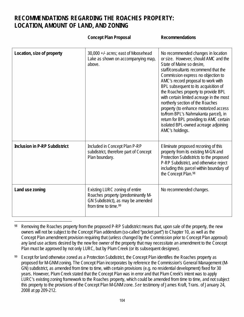
104
RECOMMENDATIONS REGARDING THE ROACHES PROPERTY: LOCATION, AMOUNT OF LAND, AND ZONING
Concept Plan Proposal Recommendations
Location, size of property 30,000 +/- acres; east of Moosehead Lake as shown on accompanying map, above.
No recommended changes in location or size. However, should AMC and the State of Maine so desire, staff/consultants recommend that the Commission express no objection to AMC’s record proposal to work with BPL subsequent to its acquisition of the Roaches property to provide BPL with certain limited acreage in the most northerly section of the Roaches property (to enhance motorized access to/from BPL’s Nahmakanta parcel), in return for BPL providing to AMC certain isolated BPL-owned acreage adjoining AMC’s holdings.
Inclusion in P-RP Subdistrict Included in Concept Plan P-RP subdistrict, therefore part of Concept Plan boundary.
Eliminate proposed rezoning of this property from its existing M-GN and Protection Subdistricts to the proposed P-RP Subdistrict, and otherwise reject including this parcel within boundary of the Concept Plan.98
Land use zoning Existing LURC zoning of entire Roaches property (predominantly M-GN Subdistrict), as may be amended from time to time.99
No recommended changes.
98 Removing the Roaches property from the proposed P-RP Subdistrict means that, upon sale of the property, the new
owners will not be subject to the Concept Plan addendum (so-called “pocket part”) to Chapter 10, as well as the Concept Plan amendment provision requiring that (unless changed by the Commission prior to Concept Plan approval) any land use actions desired by the new fee owner of the property that may necessitate an amendment to the Concept Plan must be approved by not only LURC, but by Plum Creek (or its subsequent designee).
99 Except for land otherwise zoned as a Protection Subdistrict, the Concept Plan identifies the Roaches property as proposed for M-GNM zoning. The Concept Plan incorporates by reference the Commission’s General Management (M-GN) subdistrict, as amended from time to time, with certain provisions (e.g. no residential development) fixed for 30 years. However, Plum Creek stated that the Concept Plan was in error and that Plum Creek’s intent was to apply LURC’s existing zoning framework to the Roaches property, which could be amended from time to time, and not subject this property to the provisions of the Concept Plan M-GNM zone. See testimony of James Kraft, Trans. of January 24, 2008 at pp 209-212.

105
RECOMMENDATIONS REGARDING THE ROACHES PROPERTY: PURCHASE TERMS, INCLUDING TIMING OF PURCHASE
Concept Plan Proposal Recommendations
Purchaser of Roaches property Sale of entire property in fee by Plum Creek to The Nature Conservancy (TNC) subject to terms and conditions in October 2006 purchase and sale agreement between two organizations.
Assignment and sale of property to Appalachian Mountain Club (AMC) by TNC.
No recommended changes.
Purchase price $14,750,000. No recommended changes.
Timing of sale of property to TNC and assignment to AMC; conditions on sale
Allowed up to five years subsequent to LURC’s “approval of a long-term concept plan and Seller’s acceptance of a Plan...”
No later than 45 days after a Commission-approved Concept Plan becomes final, PC must demonstrate to the Commission that (a) a final fee sale by Plum Creek to TNC of the entire Roaches property, followed by a complete transfer of ownership to AMC of the entire Roaches property has occurred; and (b) a conservation easement containing LURC-approved terms and conditions has been placed and recorded on the entire Roaches property, either contemporaneous to the closing of the fee sale or immediately thereafter (see Post-Sale Restrictions on use of the Roaches property, below).
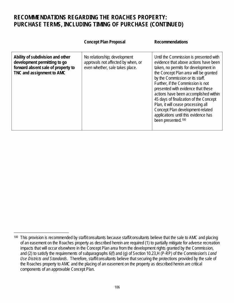
106
RECOMMENDATIONS REGARDING THE ROACHES PROPERTY: PURCHASE TERMS, INCLUDING TIMING OF PURCHASE (CONTINUED)
Concept Plan Proposal Recommendations
Ability of subdivision and other development permitting to go forward absent sale of property to TNC and assignment to AMC
No relationship; development approvals not affected by when, or even whether, sale takes place.
Until the Commission is presented with evidence that above actions have been taken, no permits for development in the Concept Plan area will be granted by the Commission or its staff. Further, if the Commission is not presented with evidence that these actions have been accomplished within 45 days of finalization of the Concept Plan, it will cease processing all Concept Plan development-related applications until this evidence has been presented.100
100 This provision is recommended by staff/consultants because staff/consultants believe that the sale to AMC and placing
of an easement on the Roaches property as described herein are required (1) to partially mitigate for adverse recreation impacts that will occur elsewhere in the Concept Plan area from the development rights granted by the Commission, and (2) to satisfy the requirements of subparagraphs 6(f) and (g) of Section 10.23,H (P-RP) of the Commission’s Land Use Districts and Standards. Therefore, staff/consultants believe that securing the protections provided by the sale of the Roaches property to AMC and the placing of an easement on the property as described herein are critical components of an approvable Concept Plan.

107
RECOMMENDATIONS REGARDING THE ROACHES PROPERTY: POST-SALE RESTRICTIONS ON USE OF THE ROACHES PROPERTY Concept Plan Proposal Recommendations
Post-sale restrictions on use of property by AMC and any subsequent owner(s)
No restrictions other than specified ATV and snowmobile easement, and certain limited reserved rights by Plum Creek to gravel extraction in small portion of the property. Consequently, subdivision for residential development, either by petition for rezoning to LURC or via the use of 2-in-5 subdivision lot creation could occur.
In addition to specified easements/restrictions stipulated in the purchase and sale agreement, a conservation easement, held by an appropriate party capable of monitoring and enforcement, must be placed on Roaches property and recorded at closing or immediately thereafter to ensure that the Roaches property will, in perpetuity, provide for mitigation of certain primitive recreation values that will be adversely impacted by the development rights granted by the Commission in the Concept Plan.
Easement shall guarantee public access to the entire Roaches property, and ensure protection of remote, undeveloped, primitive and non-motorized backcountry recreational opportunities, consistent with easements conveyed at time of sale and necessary management of public access by AMC or its designee.101
101 This requirement would make binding and enforceable AMC’s stated intent contained in its oral and written testimony
before the Commission -- namely, that AMC intends that the usage of the Roaches property will be solely for remote, undeveloped, primitive and non-motorized backcountry recreational opportunities, open and available to all persons. Specific conservation easement measures to ensure this general purpose is achieved would include:
Guaranteed non-motorized public access to all portions of the parcel, except where easement terms contained in the P&S provided to the Commission during the hearings specify areas of limited motorized access;
Elimination entirely of all residential, commercial or industrial development on the parcel, except for development and maintenance of a limited number of primitive campsites and shelters, self-service cabins and sporting camps and minor structures necessary to support these uses, and forest practices and related required structures;
Protections of remote backcountry experience, including protections of scenic values from harvesting and other activities on trails and public waters;
Elimination of subdivisions of the parcel, except what might be required to allow a future lands trade with BPL; and
Prohibition on sale or assignment of parcel to buyer who does not have the demonstrated capability and stated intent to manage the parcel consistent with the purposes of the easement and its restrictions.

CONSERVATION FRAMEWORK: BOG PROPERTIES
SUMMARY OF KEY ELEMENTS OF CONCEPT PLAN PROPOSAL FOR THE BOG PROPERTIES COMPONENT OF THE CONSERVATION FRAMEWORK Conditioned upon approval by the Commission of a Concept Plan that is acceptable to Plum Creek, Plum Creek has agreed to sell a 45,000 +/- tract of land south of the Moosehead Lake region known as the Bog Properties (as shown on the map, below as “Number Five Bog Acquisition”)102 to The Nature Conservancy (TNC), pursuant to the terms and conditions stated in a purchase and sale agreement executed with TNC.103 TNC and Plum Creek have five years after approval of a Concept Plan that is acceptable to Plum Creek to close on the sale of the Bog Properties.
102 This land is located in Bradstreet, Raytown and Appleton and Hobbstown Townships. 103 Real Estate Purchase and Sale Agreement, No. 560-5.06-5670 and Option to Purchase Property, October 2006, as
extended. The Purchase and Sale agreement allows purchase by TNC of approximately 4,821 designated acres that are part of the Bog Properties for the price of $1,387,000, even if the P&S is terminated with respect to all other portions of the Bog Properties, in recognition of the previous receipt by TNC of Land for Maine’s Future funding assistance for this 4,821 acres.
108
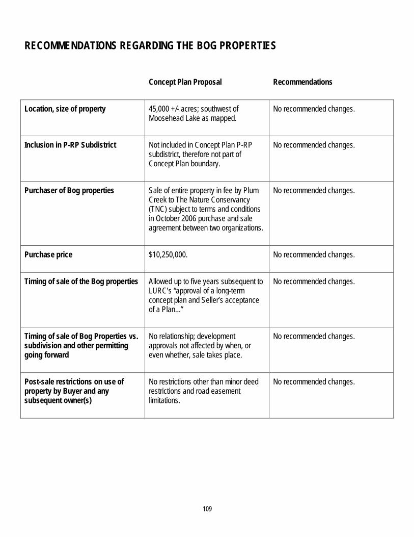
109
RECOMMENDATIONS REGARDING THE BOG PROPERTIES
Concept Plan Proposal Recommendations
Location, size of property 45,000 +/- acres; southwest of Moosehead Lake as mapped.
No recommended changes.
Inclusion in P-RP Subdistrict Not included in Concept Plan P-RP subdistrict, therefore not part of Concept Plan boundary.
No recommended changes.
Purchaser of Bog properties
Sale of entire property in fee by Plum Creek to The Nature Conservancy (TNC) subject to terms and conditions in October 2006 purchase and sale agreement between two organizations.
No recommended changes.
Purchase price $10,250,000. No recommended changes.
Timing of sale of the Bog properties Allowed up to five years subsequent to LURC’s “approval of a long-term concept plan and Seller’s acceptance of a Plan...”
No recommended changes.
Timing of sale of Bog Properties vs. subdivision and other permitting going forward
No relationship; development approvals not affected by when, or even whether, sale takes place.
No recommended changes.
Post-sale restrictions on use of property by Buyer and any subsequent owner(s)
No restrictions other than minor deed restrictions and road easement limitations.
No recommended changes.

110
ADDITIONAL CONCEPT PLAN ELEMENTS

111
ADDITIONAL CONCEPT PLAN ELEMENTS
In addition to the proposed development and conservation elements within the Concept Plan, Plum Creek has proposed the following Concept Plan elements:
Snowmobile trail easements;
Peak-to-Beak trail easement;
Hut-to-Hut trail easement;
Vehicular road access easements;
Land donations to BPL; and
Affordable housing.
Pertinent details of Plum Creek’s proposal for these additional Concept Plan elements are set forth in the table that follows.
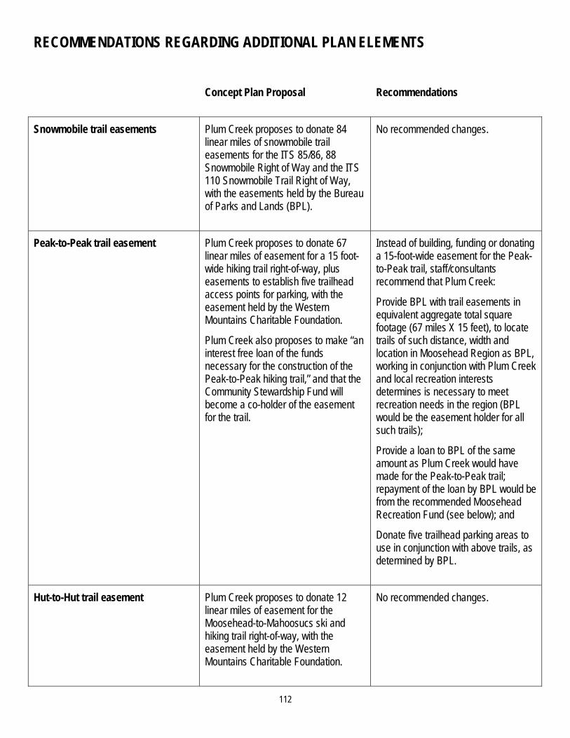
112
RECOMMENDATIONS REGARDING ADDITIONAL PLAN ELEMENTS
Concept Plan Proposal Recommendations
Snowmobile trail easements
Plum Creek proposes to donate 84 linear miles of snowmobile trail easements for the ITS 85/86, 88 Snowmobile Right of Way and the ITS 110 Snowmobile Trail Right of Way, with the easements held by the Bureau of Parks and Lands (BPL).
No recommended changes.
Peak-to-Peak trail easement
Plum Creek proposes to donate 67 linear miles of easement for a 15 foot-wide hiking trail right-of-way, plus easements to establish five trailhead access points for parking, with the easement held by the Western Mountains Charitable Foundation.
Plum Creek also proposes to make “an interest free loan of the funds necessary for the construction of the Peak-to-Peak hiking trail,” and that the Community Stewardship Fund will become a co-holder of the easement for the trail.
Instead of building, funding or donating a 15-foot-wide easement for the Peak-to-Peak trail, staff/consultants recommend that Plum Creek:
Provide BPL with trail easements in equivalent aggregate total square footage (67 miles X 15 feet), to locate trails of such distance, width and location in Moosehead Region as BPL, working in conjunction with Plum Creek and local recreation interests determines is necessary to meet recreation needs in the region (BPL would be the easement holder for all such trails);
Provide a loan to BPL of the same amount as Plum Creek would have made for the Peak-to-Peak trail; repayment of the loan by BPL would be from the recommended Moosehead Recreation Fund (see below); and
Donate five trailhead parking areas to use in conjunction with above trails, as determined by BPL.
Hut-to-Hut trail easement Plum Creek proposes to donate 12 linear miles of easement for the Moosehead-to-Mahoosucs ski and hiking trail right-of-way, with the easement held by the Western Mountains Charitable Foundation.
No recommended changes.

113
RECOMMENDATIONS REGARDING ADDITIONAL PLAN ELEMENTS (CONTINUED) Concept Plan Proposal Recommendations
Vehicular road access easements Plum Creek proposes to donate to BPL approximately 57 miles of road easements granting to the public the right of vehicular access to major forest management roads for public recreational use, including use for commercial recreation, such as rafting, outfitters, and traditional outdoor guides.
The grant of these easements would be sequenced, based on LURC approvals of specific resort master plan and residential subdivision approvals. The proposed sequencing of easements is:
Upon approval of all proposed Lily Bay development: Sias Hill Road, two connecting roads between Casey’s Road and Moosehead Lake, a portion of the Kokadjo to Nahmakanta Road, a portion of the Kokadjo to West Branch Ponds Road, and the Greenville to Hedgehog Checkpoint Road (a.k.a. KI Road)
Upon approval of Upper Wilson Pond subdivision: Prong Pond Road from Lily Bay Road to Upper Wilson Pond.
Upon approval of Big Moose Mountain Resort Master Plan: Capital Road to Somerset Road (Route 201) and Chase Stream Pond area.
Upon approval of Big Moose Mountain Resort Master Plan and Brassua Lake subdivision: 20 Mile Road across Soldiertown.
No recommended changes to the location of proposed vehicular road access easements.
Amend sequencing as follows:
Concurrent with LURC subdivision/ development approval for the first 200 residential and/or resort accommodation units on the east side of Moosehead Lake, execute easements for the following road segments: Sias Hill Road; two connecting roads between Casey’s Road and Moosehead Lake; a portion of the Kokadjo to Nahmakanta Road; a portion of the Kokadjo to West Branch Ponds Road; and Greenville to Hedgehog Checkpoint Road (a.k.a. KI Road).
Concurrent with LURC subdivision/ development approval for the first 200 residential and/or resort accommodation units on the east side of Moosehead Lake, execute easements for the following road segments: 20 Mile Road across Soldiertown.
Concurrent with LURC subdivision/ development approval for the second 200 residential and/or resort accommodation units on the east side of Moosehead Lake, execute easements for the following road segments: Capital Road to Somerset Road (Route 201) and Chase Stream Pond area.
(Continued on next page)

114
RECOMMENDATIONS REGARDING ADDITIONAL PLAN ELEMENTS (CONTINUED)
Concept Plan Proposal Recommendations
Vehicular road access easements (continued)
If, at the end of the 30-year term of the Concept Plan, Plum Creek has not sought subdivision or development approval for at least 200 units on the east side of Moosehead Lake and at least 400 units on the west side of Moosehead Lake, these easements will nevertheless be executed. If, however, Plum Creek seeks such approvals and is denied at the subdivision/ development review stage so that these unit thresholds cannot be met at the end of the 30-year term, the easements would not be executed.
Confirm that as of the date of Concept Plan approval, easements to BPL currently under development (outside of this Concept Plan proceeding) for Spencer Bay Road, Casey’s Road, and Hardwood Valley Road (parallel to and south of Roach River) have been or will be executed.
Direct staff/consultants and the legal counsel to Commission to undertake a thorough review of all text of the proposed vehicular access easements and make any recommended language changes to the Commission as a result of this review.
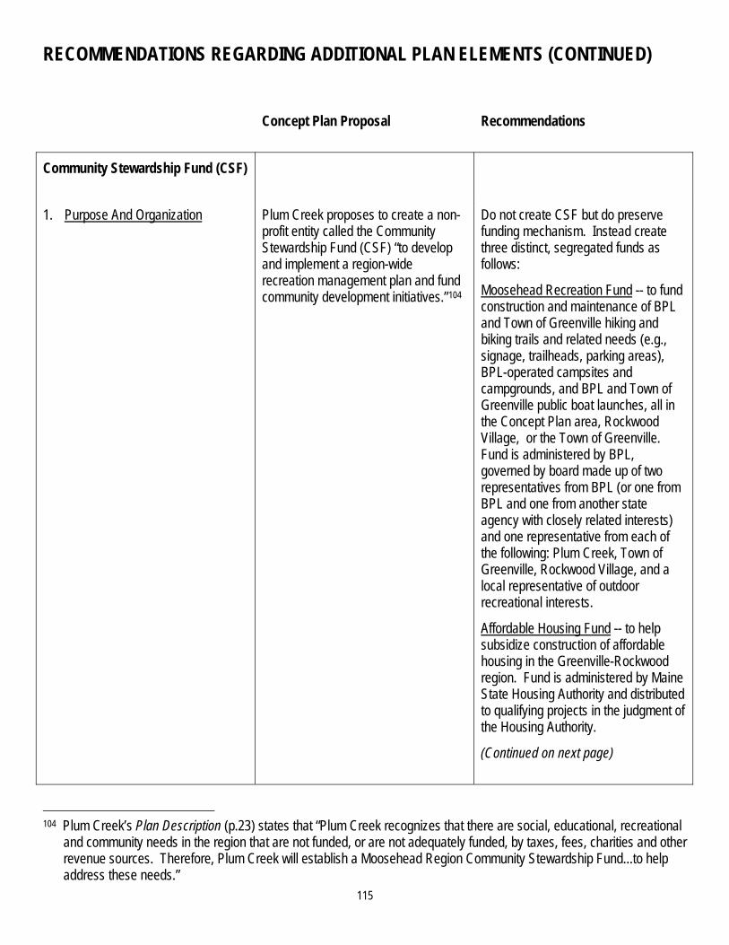
115
RECOMMENDATIONS REGARDING ADDITIONAL PLAN ELEMENTS (CONTINUED)
Concept Plan Proposal Recommendations
Community Stewardship Fund (CSF)
1. Purpose And Organization
Plum Creek proposes to create a non-profit entity called the Community Stewardship Fund (CSF) “to develop and implement a region-wide recreation management plan and fund community development initiatives.”104
Do not create CSF but do preserve funding mechanism. Instead create three distinct, segregated funds as follows:
Moosehead Recreation Fund -- to fund construction and maintenance of BPL and Town of Greenville hiking and biking trails and related needs (e.g., signage, trailheads, parking areas), BPL-operated campsites and campgrounds, and BPL and Town of Greenville public boat launches, all in the Concept Plan area, Rockwood Village, or the Town of Greenville. Fund is administered by BPL, governed by board made up of two representatives from BPL (or one from BPL and one from another state agency with closely related interests) and one representative from each of the following: Plum Creek, Town of Greenville, Rockwood Village, and a local representative of outdoor recreational interests.
Affordable Housing Fund -- to help subsidize construction of affordable housing in the Greenville-Rockwood region. Fund is administered by Maine State Housing Authority and distributed to qualifying projects in the judgment of the Housing Authority.
(Continued on next page)
104 Plum Creek’s Plan Description (p.23) states that “Plum Creek recognizes that there are social, educational, recreational
and community needs in the region that are not funded, or are not adequately funded, by taxes, fees, charities and other revenue sources. Therefore, Plum Creek will establish a Moosehead Region Community Stewardship Fund...to help address these needs.”

116
RECOMMENDATIONS REGARDING ADDITIONAL PLAN ELEMENTS (CONTINUED)
Concept Plan Proposal Recommendations
Purpose And Organization (continued)
Wildlife and Invasive Species Fund – to help fund loon nesting and other wildlife needs and control the spread of invasive species resulting from Concept Plan development. Fund is administered jointly by IFW, MNAP and Maine DEP. Funds are distributed to qualifying projects in the judgment of these agencies.
2. Funding for CSF activities To fund this entity, Plum Creek proposes to donate 2% of the sales price from the sale of the residential lots proposed in the Concept Plan and ½ % of the sales price of subsequent sales of these 975 residential dwelling units. From funds collected by the CSF, Plum Creek proposes to pay expenses incurred by Florida Power and Light (FPL) due to increased obligations that FPL may face for meeting public needs under its federal hydropower licenses as a result of Plum Creek’s development.
Funding mechanism preserved but distribution/allocation changed as follows:
No funding allocated to fulfilling Plum Creek’s responsibilities to FPL; responsibility rests exclusively with Plum Creek; and
Funding from lot sales evenly distributed as received as follows: 45% of funds to Moosehead Recreation Fund; 45% of funds to Affordable Housing Fund; and 10% of funds to Wildlife and Invasive Species Fund.
3. Land donations to BPL Plum Creek proposes to donate “up to 50 acres in the aggregate of property protected by the Balance Easement and the Legacy Easement to BPL to address future recreation needs identified by BPL and the Moosehead Region Community Stewardship Fund.” 105
50 acres donation used for new BPL campsites and campgrounds or public boat launches in the easement areas, and for additional trailhead parking areas over and above five areas donated above if needed by BPL.
105 Plan Description, Section 2, p 20 (October 2007).

117
RECOMMENDATIONS REGARDING ADDITIONAL PLAN ELEMENTS (CONTINUED)
Concept Plan Proposal Recommendations
4. Affordable housing Plum Creek has donated 25 acres of land and made a reduced-interest loan of $800,000 to Coastal Enterprises, Inc. to create affordable housing in the Moosehead Lake Region.
Upon Concept Plan approval, Plum Creek proposes to make one or more additional land donations totaling 75 acres, and make an additional reduced-interest loan of $950,000.
Plum Creek proposes that affordable housing within the Concept Plan area can be located in the following development areas: Rockwood/Blue Ridge, Route 6/15 Corridor, Moose Bay, Beaver Cove, and Big Moose Mountain.
The number of housing units that may be built would be uncapped in each development area and in addition to the 975 residential dwelling units and 1,025 resort accommodation units.
Allow second phase of Plum Creek-Coastal Enterprises, Inc. arrangement to proceed.
Change permitted land uses in zones so that multi-unit housing allowed in all development areas.106
Require demonstration of adequate employee housing on-site or off-site as part of long-term development plans for resorts.
Create Affordable Housing Fund, per recommendation, above.
106 For details, see recommendation, Land Use Zones (Permitted Uses).

118
CONCEPT PLAN IMPLEMENTATION MECHANISMS

119
CONCEPT PLAN AMENDMENT
SUMMARY OF KEY ELEMENTS OF CONCEPT PLAN PROPOSAL GOVERNING PLAN AMENDMENT If the Commission approves the Concept Plan, its terms would remain in effect for the 30-year term of the Plan unless
amended.
The terms of the Concept Plan could only be amended by agreement between Plum Creek or its assignee, and the Commission. Either party could propose an amendment, but neither could amend the Plan unilaterally. The Commission could not alter the terms of the Concept Plan in any way without the consent of Plum Creek or its assignee.
Plum Creek has proposed alternative approaches for Plan amendment following the sale of individual subdivision lots. Under the first approach, Plum Creek would retain the sole right to consent to Concept Plan amendments during the 30-year term of the plan, regardless of whether it has sold land within the Plan area to other parties.107 Under the second approach, Plum Creek would create a parliamentary/representative system of decision-making on amendments through by-laws of homeowner associations.108 This system could provide individual property owners influence over the amendment process proportionate to their ownership, though Plum Creek has not specified precisely how it would be designed.
All land identified in the Concept Plan as development zones, including all protection and management zones adjoining or surrounded by such zones, would be governed by the terms of the Concept Plan for the Plan’s 30-year term. In the case of protection zones adjoining or surrounded by development zones, their boundaries and several of their presently allowable uses would be fixed for the term of the Concept Plan.109 All other land within the Concept Plan boundaries would be governed by Chapter 10, as the Commission may amend it, as well as the terms of the Balance and Legacy easements.
The boundaries of the Concept Plan include both the Roaches Property and the Balance and Legacy easements. Therefore, limitations on amending the Plan would affect this land, as well as land within development zones.
107 The Concept Plan itself does not address this directly, but Plum Creek stated this position in a written response to a
LURC staff information request dated June 25, 2007. 108 See testimony of James Kraft and John Hemplemann, Trans. of January 24, 2008 at pp 166-175. 109 For more detail, see recommendations on Land Use Zoning (Permitted Uses).
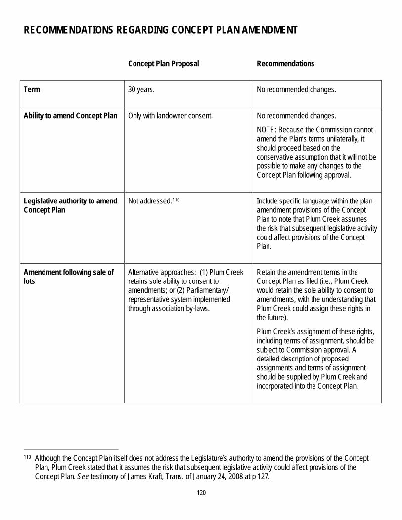
120
RECOMMENDATIONS REGARDING CONCEPT PLAN AMENDMENT
Concept Plan Proposal Recommendations
Term 30 years. No recommended changes.
Ability to amend Concept Plan Only with landowner consent. No recommended changes.
NOTE: Because the Commission cannot amend the Plan’s terms unilaterally, it should proceed based on the conservative assumption that it will not be possible to make any changes to the Concept Plan following approval.
Legislative authority to amend Concept Plan
Not addressed.110 Include specific language within the plan amendment provisions of the Concept Plan to note that Plum Creek assumes the risk that subsequent legislative activity could affect provisions of the Concept Plan.
Amendment following sale of lots
Alternative approaches: (1) Plum Creek retains sole ability to consent to amendments; or (2) Parliamentary/ representative system implemented through association by-laws.
Retain the amendment terms in the Concept Plan as filed (i.e., Plum Creek would retain the sole ability to consent to amendments, with the understanding that Plum Creek could assign these rights in the future).
Plum Creek’s assignment of these rights, including terms of assignment, should be subject to Commission approval. A detailed description of proposed assignments and terms of assignment should be supplied by Plum Creek and incorporated into the Concept Plan.
110 Although the Concept Plan itself does not address the Legislature’s authority to amend the provisions of the Concept
Plan, Plum Creek stated that it assumes the risk that subsequent legislative activity could affect provisions of the Concept Plan. See testimony of James Kraft, Trans. of January 24, 2008 at p 127.

121
RECOMMENDATIONS REGARDING CONCEPT PLAN AMENDMENT (CONTINUED)
Concept Plan Proposal Recommendations
Applicability of Concept Plan standards (so-called “pocket part” to Chapter 10) vs. LURC’s Chapter 10 standards
All land designated as development zones within the Concept Plan would be governed by the fixed standards set forth in the Plan and supplemented by LURC’s Chapter 10 (the fixed Concept Plan standards would control in the event of any inconsistencies); all other land within the Plan boundaries would be governed by LURC’s Chapter 10, as may be amended from time to time.
See recommendation, Land Use Zoning (Permitted Uses).
Applicability of amendment limitations to Roaches property and Balance and Legacy easement lands
Amendment limitations apply. Exclude the Roaches property from Concept Plan boundaries (see recommendations, Conservation Framework: The Roaches Property and Conservation Framework: Moosehead Legacy Easement). Therefore, limitations on amendment would not apply to the Roaches property, but would apply to the Balance and Legacy easement lands.

122
COVENANTS, CONDITIONS AND RESTRICTIONS (CCRs) APPLICABLE TO SUBDIVISIONS
SUMMARY OF KEY ELEMENTS OF CONCEPT PLAN PROPOSAL GOVERNING CCRs Plum Creek included with its proposed Concept Plan a sample Declaration of Covenants, Conditions and Restrictions (“CCRs”) that could apply to lots and common areas within residential subdivisions for single-family homes and, it appears (although not explicitly stated), to subdivisions associated with resort-related development in the Lily Bay and Big Moose Mountain development areas. Generally these CCRs set forth requirements and limitations on the use, improvement and maintenance of lots, common areas, roads and driveways within subdivisions. The CCRs also describe members’ procedural rights and responsibilities, including those relating to the payment of association dues, voting rights and enforcement procedures.

123
RECOMMENDATIONS REGARDING CCRs Generally, any regulatory requirement that is important to the Commission as a measure to protect or promote the public health, safety or welfare should be included in the proposed Concept Plan addendum (so-called “pocket part”) to Chapter 10, regardless of whether Plum Creek also chooses to include it in CCRs. Ensuring that all such standards appear in the Chapter 10 addendum provides the Commission with a direct means of enforcement independent of homeowner associations.
Further, staff/consultants make the following specific recommendations regarding CCRs:
Required elements of the CCRs: As an exception, there are two elements of the proposed CCRs that are relevant to public health safety and welfare, but which are uniquely appropriate to be included in the CCRs and therefore need not also be restated verbatim in Chapter 10 addendum. These should be required elements of the CCRs for each subdivision:
Section 2.2.11, Inspection and Reporting 111 This provision should be modified to state that the report regarding compliance or non-compliance must include a statement of the inspector’s qualifications. The Chapter 10 addendum should be modified to include a corresponding provision stating that the submission of the report is an enforceable Commission requirement, and that the report and the inspector’s qualifications are subject to Commission approval. This provision should also be modified to clarify that inspection shall occur annually, rather than biannually.
Section 2.2.12, Minimizing Visibility of Structures on Non-Shorefront Lots 112 This provision governs building design within the subdivision. It is not necessary to include it separately in the Chapter 10 addendum, but given its relevance to minimizing scenic impacts, it should be a required element of the CCRs.
111 This provision reads as follows: “2.2.11 Inspection and Reporting: The Association shall, at a minimum of biannually,
hire an independent qualified third party inspector to perform an on-site survey of all lots within the Association and prepare a report regarding compliance and noncompliance with all standards and requirements applicable to the vegetative clearing and water quality within the Land Use Zones and Standards set forth in Chapter 10 of the Commission’s Rules and Standards as modified by the Concept Plan, and within these Declaration of Covenants, Conditions and Restrictions. Such inspector shall have the specific expertise to determine compliance with clearing standards and water quality. The report will be delivered to the Land Use Regulation Commission to ensure compliance.” (Volume 2 – Plan Description, October 27, 2007)
112 This provision reads as follows: “2.2.12 Minimizing Visibility of Structures on Non Shore Front Lots: While these provisions are intended to reasonably minimize the visibility of structures on back lots, some portion of structures will be visible from traveled roadways, water bodies and public property. Some design measures that may be employed for achieving the standard include, but are not limited to: Varying the floor elevations and heights of buildings. Breaking roof forms and rooflines into a series of smaller components to reflect the irregular forms of the
surrounding mountain or hillside. Sloping the roof in the direction and general angle of the natural slope of the lot. Modulating building walls to avoid a single monolithic shape and/or to reduce the visual scale of buildings.
(Volume 2 – Plan Description, October 27, 2007)

124
RECOMMENDATIONS REGARDING CCRs (CONTINUED) Required elements of Chapter 10: Two elements of the proposed CCRs should be moved to the Chapter 10 addendum. To the extent Plum Creek decides to retain parallel requirements in the CCRs, staff/consultants recommend that the parallel requirements be revised to reflect the corresponding language in the Chapter 10 addendum:
Section 2.2.3, Exterior Siding and Building Materials. The elements of this provision dealing with non-reflective materials and natural colors must be separately included in Chapter 10.113
Section 2.2.13, Lot Clearing for Structures and Opening Views. A new prescriptive vegetation clearing standard should be included in the Chapter 10 addendum, as described in Staff/consultants’ Recommendation on Scenic, Lighting and Noise Standards. To the extent Plum Creek chooses to retain a parallel provision in the CCRs, it must be consistent with, and no less protective than, the Chapter 10 provision. Any parallel CCR provision may include additional guidelines or requirements.
Consistency with Chapter 10: The following three elements of the proposed CCRs should be amended to be consistent with existing Chapter 10 requirements and certain staff/consultant recommendations, should the Commission adopt such recommendations:
Section 2.2.6, Maximum Building Height. This provision should be amended to reflect both the existing requirements in Chapter 10, (including measurement from original grade on the downhill side of the structure, a maximum height of 30 feet within 500 feet of lakes, and discretion of the Commission to limit height to 30 feet beyond 500 feet from lakes with significant or outstanding scenic values, as listed in Appendix C of Chapter 10), and new language recommended for the Chapter 10 addendum (see recommendations, Scenic, Lighting and Noise Standards) regarding Commission discretion to impose 30 foot maximum building height within viewsheds of other lakes affected by development areas).
Section 2.2.7, Docks. This provision should be amended to reflect that there will be a finite number of common docks, and no individual docks for each development area (see recommendations, Proposed Development Areas).
Section 2.2.10, Walking Trails. This provision should be amended to include a required bend in each walking path to divert channelized runoff, consistent with Section 10.27,B of the Commission’s Land Use Districts and Standards.
LURC approval of CCR amendment/modification: Section 9 of the proposed CCRs, Amendments and Supplemental Declarations, should be revised to prevent homeowners associations from repealing or otherwise modifying the CCRs without LURC consent.114
Liability: Staff/consultants recommend holding homeowners associations liable for violations on common property within the subdivision, but not jointly and severally liable for violations occurring on privately owned lots within the subdivision. As noted above, the homeowners association should also be liable for non-compliance with the reporting obligation set forth in Section 2.2.11 of the CCRs, and the corresponding provision to be included in the Chapter 10 addendum.
113 See recommendations regarding Scenic, Lighting and Noise Standards. 114 Plum Creek agrees with this recommendation. See testimony of James Kraft, January 25, 2008, p 125.

125
RECOMMENDATIONS REGARDING CCRs (CONTINUED) Minimum required CCR elements: Staff/consultants recommend that the Commission direct staff/consultants to develop a fixed list of minimally required CCR elements, consistent with the above recommendations, that must be contained in the CCRs for any subsequent subdivisions (including subdivisions for residential dwelling units, resort accommodation units, caretaker/manager housing, affordable housing and employee housing), rather than the “sample” CCRs presently included in the Concept Plan.

126
SECOND TIER ISSUES

127
SECOND TIER ISSUES
RECOMMENDATIONS REGARDING SECOND TIER ISSUES The recommendations in this document address what staff/consultants have identified as the core issues presented by Plum Creek’s Concept Plan proposal. In order to establish a logical and efficient decision-making hierarchy, these recommendations intentionally do not address the many secondary issues that will need to be resolved if and when the Commission determines that amendments to the Concept Plan are appropriate and what these amendments would be. Thus, these recommendations do not present the exact Concept Plan language that would be required to implement these recommendations. 115 Staff/consultants believe such issues either cannot or should not be addressed until resolution of the recommendations presented herein has been completed.
Therefore, staff/consultants recommend that second tier, implementing issues not be addressed at this time and that the Commission determine at a later date, after consideration of comments from the petitioner and parties on the preliminary decisions made by the Commission during the deliberative sessions, whether it wishes to direct staff/consultants to prepare Concept Plan amendment language that includes recommendations addressing second tier, implementing issues.
115 By way of example only, exact language would have to be developed to address (1) provisions of the Balance and
Legacy easements and other legal documents (e.g., CCRs, vehicular access easements, trail easements, etc.) in which the meaning, consistency or implications of language used (or excluded) appear unclear and require further evaluation; (2) additions, deletions and modifications included in the Concept Plan addendum (so-called “pocket part”) to Chapter 10 (e.g. changes to definitions, new definitions, edits to Sub-Chapter III land use standards); and (3) submission requirements at the subdivision/development permit review stage.