Embed Size (px)
Citation preview
STATE OF TENNESSEE
DEPARTMENT OF TRANSPORTATION ENVIRONMENTAL DIVISION
SUITE 900, JAMES K. POLK BUILDING 505 DEADERICK STREET
NASHVILLE, TENNESSEE 37243-0334
MEMORANDUM To:
Lia Obaid Design Division
From:
Matt Richards Environmental Division
Date:
March 28, 2012
Subject: ENVIRONMENTAL BOUNDARIES AND MITIGATION DESIGN FOR: Fayette County, Interstate 40 Interchange at State Route 222 P.E. 24001-0147-44 PIN 114219.00
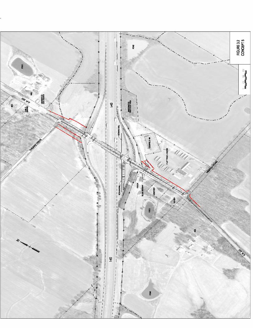
An ecological evaluation of the subject project has been conducted with the following results: X_Wetlands present: Three wetland areas are present within the project limits. Refer to attachments for locations and potential mitigation. __ No wetlands identified X Streams are present: One stream is present within the project limits. Refer to attachments for locations and potential mitigation. __No streams present in project impact area __Protected species present: X No protected species identified in project impact area __ Special haul road provisions needed: THE FOLLOWING ITEMS ARE ATTACHED FOR YOUR USE:
X
Environmental Boundaries
Mitigation Design Sketches
Narrative Mitigation Plan
Other : Marked present layout sheet

Fayette County, Interstate 40 Interchange at State Route 222 Page 2. Your assistance is appreciated. If you have any questions or comments, please contact Matt Richards in the Environmental Division at 615-532-3880 or [email protected]. xc: Jennifer Lloyd w/ attachments
Shane Hester w/ attachments Freddy Miller w/ attachments John Hewitt w/ attachments Joe Matlock w/ attachments Michael Horlacher w/ attachments Construction Rep. w/ attachments Jon Zirkle w/ attachments Project File
Reading File

WTL-3 WTL-2
WTL-1
STR-1
SPG-1
Fayette County I-40 Interchange at SR-222
P.E. 24001-0147-44PIN 114219.00
.
0 0.04 0.08 0.12 0.160.02Miles

Ecology Field Data Sheet: Water Resources
Project: Fayette County, I-40 at SR-222 P.E. 24001-0147-44 PIN 114219.00 Date of survey: 3/22/2012 Biologist: Matt Richards Affiliation: TDOT
1-Station: from plans None provided 2-Map label and name STR-1 3-Latitude/Longitude 89 24’41.27”W 35 23’40.18”N 4-Potential impact Crossing 5-Feature description: what is it Intermittent stream blue-line on topo? (y/n) No defined channel (y/n) Yes straight or meandering Straight channel bottom width 1’ top of bank width 6’ bank height and slope ratio 3’ avg. gradient of stream (%) substratum Soil, leaves riffle/run/pool 20/0/80 width of buffer zone LB: 7’ RB: 7’ water flow Slight water depth 2”-1’ water width 1’ general water quality Clear, flowing OHWM indicators Bed and bank, vegetation absent, deposition groundwater connection Yes bank stability: LB, RB Eroding dominant species: LB, RB
Black willow, box elder, honeysuckle
overhead canopy (%) 85%
benthos
No
fish No algae or other aquatic life Algae habitat assessment score photo number (s) 1 Looking D/S from farm road crossing; 2 looking U/S from farm road crossing rainfall information 4.69” in previous two weeks
6- HUC code & name (12-digit) 080102080402, Big Muddy Creek, Lower
7-Confirmed by: Unnecessary 8-Mitigation No_____ Yes_____ : (include on Form J)
9-ETW No__X___ Yes_____
10-303 (d) List
No __X___ Yes_____: Habitat_____ Siltation_____
11-Notes Estimate size (acres) of lake or pond if applicable; provide any pertinent information needed to better describe feature; indicate if hydrologic determination form completed
Hydrology supplied by SPG-1.
Form G

2
1-Station: from plans None provided 2-Map label and name SPG-1 3-Latitude/Longitude 89 24’42.28”W 35 23’40.22”N 4-Potential impact Unknown 5-Feature description: what is it Spring blue-line on topo? (y/n) No defined channel (y/n) No straight or meandering n/a channel bottom width n/a top of bank width n/a bank height and slope ratio n/a avg. gradient of stream (%) n/a substratum Soil riffle/run/pool n/a width of buffer zone LB: 0’ RB:0’ water flow Slight water depth 1’ water width 4’ general water quality Muddy OHWM indicators n/a groundwater connection Yes bank stability: LB, RB Eroding dominant species: LB, RB
Honeysuckle, sycamore, boxelder
overhead canopy (%) 3%
benthos
No
fish No algae or other aquatic life Frogs habitat assessment score photo number (s) 3 looking SW rainfall information 4.69” in previous two weeks
6- HUC code & name (12-digit) 080102080402, Big Muddy Creek, Lower
7-Confirmed by: Unnecessary 8-Mitigation No_____ Yes_____ : (include on Form J)
9-ETW No__X___ Yes_____
10-303 (d) List
No __X___ Yes_____: Habitat_____ Siltation_____
11-Notes Estimate size (acres) of lake or pond if applicable; provide any pertinent information needed to better describe feature; indicate if hydrologic determination form completed
Unknown if proposed spur road will impact SPG-1, a spring box will be required if so. SPG-1 is the hydrology source for STR-1 and WTL-1.
US Army Corps of Engineers Atlantic and Gulf Coastal Plain Region – Interim Version
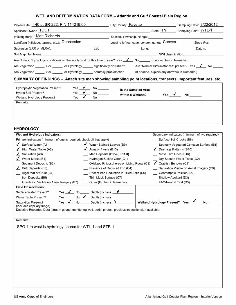
WETLAND DETERMINATION DATA FORM – Atlantic and Gulf Coastal Plain Region
Project/Site: City/County: Sampling Date:
Applicant/Owner: State: Sampling Point:
Investigator(s): Section, Township, Range:
Landform (hillslope, terrace, etc.): Local relief (concave, convex, none): Slope (%):
Subregion (LRR or MLRA): Lat: Long: Datum:
Soil Map Unit Name: NWI classification:
Are climatic / hydrologic conditions on the site typical for this time of year? Yes No (If no, explain in Remarks.)
Are Vegetation , Soil , or Hydrology significantly disturbed? Are “Normal Circumstances” present? Yes No
Are Vegetation , Soil , or Hydrology naturally problematic? (If needed, explain any answers in Remarks.)
SUMMARY OF FINDINGS – Attach site map showing sampling point locations, transects, important features, etc.
Hydrophytic Vegetation Present? Yes No Hydric Soil Present? Yes No Wetland Hydrology Present? Yes No
Is the Sampled Area within a Wetland? Yes No
Remarks:
HYDROLOGY Wetland Hydrology Indicators: Secondary Indicators (minimum of two required)Primary Indicators (minimum of one is required; check all that apply) Surface Soil Cracks (B6)
Surface Water (A1) Water-Stained Leaves (B9) Sparsely Vegetated Concave Surface (B8) High Water Table (A2) Aquatic Fauna (B13) Drainage Patterns (B10) Saturation (A3) Marl Deposits (B15) (LRR U) Moss Trim Lines (B16) Water Marks (B1) Hydrogen Sulfide Odor (C1) Dry-Season Water Table (C2) Sediment Deposits (B2) Oxidized Rhizospheres on Living Roots (C3) Crayfish Burrows (C8) Drift Deposits (B3) Presence of Reduced Iron (C4) Saturation Visible on Aerial Imagery (C9) Algal Mat or Crust (B4) Recent Iron Reduction in Tilled Soils (C6) Geomorphic Position (D2) Iron Deposits (B5) Thin Muck Surface (C7) Shallow Aquitard (D3) Inundation Visible on Aerial Imagery (B7) Other (Explain in Remarks) FAC-Neutral Test (D5)
Field Observations: Surface Water Present? Yes No Depth (inches): Water Table Present? Yes No Depth (inches): Saturation Present? Yes No Depth (inches): (includes capillary fringe)
Wetland Hydrology Present? Yes No
Describe Recorded Data (stream gauge, monitoring well, aerial photos, previous inspections), if available:
Remarks:
I-40 at SR-222, PIN 114219.00 Fayette 3/22/2012
TDOT TN WTL-1
Matt Richards
Depression Convex
✔
✔
✔
✔✔
✔
✔✔✔✔
✔
✔✔ ✔
✔
SPG-1 to west is hydrology source for WTL-1 and STR-1
✔
✔
✔1-6
0 ✔

US Army Corps of Engineers Atlantic and Gulf Coastal Plain Region – Interim Version
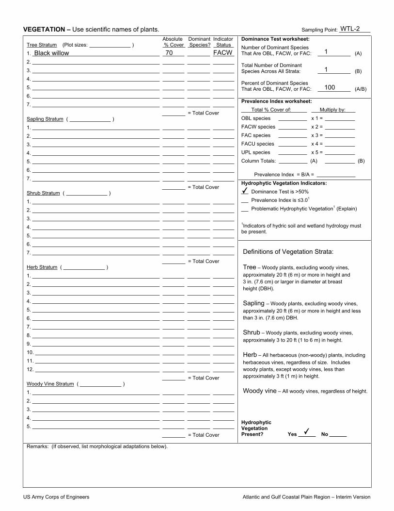
VEGETATION – Use scientific names of plants. Sampling Point:
Dominance Test worksheet: Number of Dominant Species That Are OBL, FACW, or FAC: (A)
Total Number of Dominant Species Across All Strata: (B)
Percent of Dominant Species That Are OBL, FACW, or FAC: (A/B)
Prevalence Index worksheet: Total % Cover of: Multiply by: OBL species x 1 = FACW species x 2 = FAC species x 3 = FACU species x 4 = UPL species x 5 = Column Totals: (A) (B)
Prevalence Index = B/A = Hydrophytic Vegetation Indicators:
Dominance Test is >50% Prevalence Index is 3.01
Problematic Hydrophytic Vegetation1 (Explain)
1Indicators of hydric soil and wetland hydrology must be present.
Absolute Dominant Indicator Tree Stratum (Plot sizes: ) % Cover Species? Status1. 2. 3. 4. 5. 6. 7.
= Total Cover Sapling Stratum ( ) 1. 2. 3. 4. 5. 6. 7.
= Total Cover Shrub Stratum ( ) 1. 2. 3. 4. 5. 6. 7.
= Total Cover Herb Stratum ( ) 1. 2. 3. 4. 5. 6. 7. 8. 9. 10. 11. 12.
= Total Cover Woody Vine Stratum ( ) 1. 2. 3. 4. 5.
= Total Cover
Hydrophytic Vegetation Present? Yes No
Remarks: (If observed, list morphological adaptations below).
Definitions of Vegetation Strata:
Tree – Woody plants, excluding woody vines, approximately 20 ft (6 m) or more in height and 3 in. (7.6 cm) or larger in diameter at breast height (DBH).
Sapling – Woody plants, excluding woody vines,approximately 20 ft (6 m) or more in height and lessthan 3 in. (7.6 cm) DBH.
Shrub – Woody plants, excluding woody vines,approximately 3 to 20 ft (1 to 6 m) in height.
Herb – All herbaceous (non-woody) plants, includingherbaceous vines, regardless of size. Includeswoody plants, except woody vines, less thanapproximately 3 ft (1 m) in height.
Woody vine – All woody vines, regardless of height.
black willow
boxelder
honeysuckel
60
10
5
yes
yes
yes
FACW
FACW
2
3
66
✔
✔
WTL-1
US Army Corps of Engineers Atlantic and Gulf Coastal Plain Region – Interim Version
SOIL Sampling Point:
Profile Description: (Describe to the depth needed to document the indicator or confirm the absence of indicators.) Depth Matrix Redox Features (inches) Color (moist) % Color (moist) % Type1 Loc2 Texture Remarks
1Type: C=Concentration, D=Depletion, RM=Reduced Matrix, CS=Covered or Coated Sand Grains. 2Location: PL=Pore Lining, M=Matrix.Hydric Soil Indicators: Indicators for Problematic Hydric Soils3:
Histosol (A1) Polyvalue Below Surface (S8) (LRR S, T, U) 1 cm Muck (A9) (LRR O) Histic Epipedon (A2) Thin Dark Surface (S9) (LRR S, T, U) 2 cm Muck (A10) (LRR S) Black Histic (A3) Loamy Mucky Mineral (F1) (LRR O) Reduced Vertic (F18) (outside MLRA 150A,B) Hydrogen Sulfide (A4) Loamy Gleyed Matrix (F2) Piedmont Floodplain Soils (F19) (LRR P, S, T) Stratified Layers (A5) Depleted Matrix (F3) Anomalous Bright Loamy Soils (F20) Organic Bodies (A6) (LRR P, T, U) Redox Dark Surface (F6) (MLRA 153B) 5 cm Mucky Mineral (A7) (LRR P, T, U) Red Parent Material (TF2) Muck Presence (A8) (LRR U) Redox Depressions (F8)
Other (Explain in Remarks) 1 cm Muck (A9) (LRR P, T) Marl (F10) (LRR U) Depleted Below Dark Surface (A11) Depleted Ochric (F11) (MLRA 151)
3Indicators of hydrophytic vegetation and Thick Dark Surface (A12) Iron-Manganese Masses (F12) (LRR O, P, T)
wetland hydrology must be present. Coast Prairie Redox (A16) (MLRA 150A) Umbric Surface (F13) (LRR P, T, U) Sandy Mucky Mineral (S1) (LRR O, S) Delta Ochric (F17) (MLRA 151) Sandy Gleyed Matrix (S4) Reduced Vertic (F18) (MLRA 150A, 150B) Sandy Redox (S5) Piedmont Floodplain Soils (F19) (MLRA 149A) Stripped Matrix (S6) Anomalous Bright Loamy Soils (F20) (MLRA 149A, 153C, 153D) Dark Surface (S7) (LRR P, S, T, U)
Restrictive Layer (if observed): Type: Depth (inches): Hydric Soil Present? Yes No Remarks:
Very Shallow Dark Surface (TF12) (LRR T, U) Depleted Dark Surface (F7)
10 10YR 6/1 90 7.5YR 5/6 5
WTL-1
✔
✔

US Army Corps of Engineers Atlantic and Gulf Coastal Plain Region – Interim Version
WETLAND DETERMINATION DATA FORM – Atlantic and Gulf Coastal Plain Region
Project/Site: City/County: Sampling Date:
Applicant/Owner: State: Sampling Point:
Investigator(s): Section, Township, Range:
Landform (hillslope, terrace, etc.): Local relief (concave, convex, none): Slope (%):
Subregion (LRR or MLRA): Lat: Long: Datum:
Soil Map Unit Name: NWI classification:
Are climatic / hydrologic conditions on the site typical for this time of year? Yes No (If no, explain in Remarks.)
Are Vegetation , Soil , or Hydrology significantly disturbed? Are “Normal Circumstances” present? Yes No
Are Vegetation , Soil , or Hydrology naturally problematic? (If needed, explain any answers in Remarks.)
SUMMARY OF FINDINGS – Attach site map showing sampling point locations, transects, important features, etc.
Hydrophytic Vegetation Present? Yes No Hydric Soil Present? Yes No Wetland Hydrology Present? Yes No
Is the Sampled Area within a Wetland? Yes No
Remarks:
HYDROLOGY Wetland Hydrology Indicators: Secondary Indicators (minimum of two required)Primary Indicators (minimum of one is required; check all that apply) Surface Soil Cracks (B6)
Surface Water (A1) Water-Stained Leaves (B9) Sparsely Vegetated Concave Surface (B8) High Water Table (A2) Aquatic Fauna (B13) Drainage Patterns (B10) Saturation (A3) Marl Deposits (B15) (LRR U) Moss Trim Lines (B16) Water Marks (B1) Hydrogen Sulfide Odor (C1) Dry-Season Water Table (C2) Sediment Deposits (B2) Oxidized Rhizospheres on Living Roots (C3) Crayfish Burrows (C8) Drift Deposits (B3) Presence of Reduced Iron (C4) Saturation Visible on Aerial Imagery (C9) Algal Mat or Crust (B4) Recent Iron Reduction in Tilled Soils (C6) Geomorphic Position (D2) Iron Deposits (B5) Thin Muck Surface (C7) Shallow Aquitard (D3) Inundation Visible on Aerial Imagery (B7) Other (Explain in Remarks) FAC-Neutral Test (D5)
Field Observations: Surface Water Present? Yes No Depth (inches): Water Table Present? Yes No Depth (inches): Saturation Present? Yes No Depth (inches): (includes capillary fringe)
Wetland Hydrology Present? Yes No
Describe Recorded Data (stream gauge, monitoring well, aerial photos, previous inspections), if available:
Remarks:
I-40 at SR-222 PIN 114219.00 Fayette 3/22/2012
TDOT TN WTL-2
Matt Richards
Depression Convex
✔
✔
Photo 5 looking east
✔
✔✔
✔
Water held between I-40 ramp and berm to north.
✔
✔
✔2-4
0 ✔
US Army Corps of Engineers Atlantic and Gulf Coastal Plain Region – Interim Version
VEGETATION – Use scientific names of plants. Sampling Point:
Dominance Test worksheet: Number of Dominant Species That Are OBL, FACW, or FAC: (A)
Total Number of Dominant Species Across All Strata: (B)
Percent of Dominant Species That Are OBL, FACW, or FAC: (A/B)
Prevalence Index worksheet: Total % Cover of: Multiply by: OBL species x 1 = FACW species x 2 = FAC species x 3 = FACU species x 4 = UPL species x 5 = Column Totals: (A) (B)
Prevalence Index = B/A = Hydrophytic Vegetation Indicators:
Dominance Test is >50% Prevalence Index is 3.01
Problematic Hydrophytic Vegetation1 (Explain)
1Indicators of hydric soil and wetland hydrology must be present.
Absolute Dominant Indicator Tree Stratum (Plot sizes: ) % Cover Species? Status1. 2. 3. 4. 5. 6. 7.
= Total Cover Sapling Stratum ( ) 1. 2. 3. 4. 5. 6. 7.
= Total Cover Shrub Stratum ( ) 1. 2. 3. 4. 5. 6. 7.
= Total Cover Herb Stratum ( ) 1. 2. 3. 4. 5. 6. 7. 8. 9. 10. 11. 12.
= Total Cover Woody Vine Stratum ( ) 1. 2. 3. 4. 5.
= Total Cover
Hydrophytic Vegetation Present? Yes No
Remarks: (If observed, list morphological adaptations below).
Definitions of Vegetation Strata:
Tree – Woody plants, excluding woody vines, approximately 20 ft (6 m) or more in height and 3 in. (7.6 cm) or larger in diameter at breast height (DBH).
Sapling – Woody plants, excluding woody vines,approximately 20 ft (6 m) or more in height and lessthan 3 in. (7.6 cm) DBH.
Shrub – Woody plants, excluding woody vines,approximately 3 to 20 ft (1 to 6 m) in height.
Herb – All herbaceous (non-woody) plants, includingherbaceous vines, regardless of size. Includeswoody plants, except woody vines, less thanapproximately 3 ft (1 m) in height.
Woody vine – All woody vines, regardless of height.
Black willow 70 FACW 1
1
100
✔
✔
WTL-2

US Army Corps of Engineers Atlantic and Gulf Coastal Plain Region – Interim Version
SOIL Sampling Point:
Profile Description: (Describe to the depth needed to document the indicator or confirm the absence of indicators.) Depth Matrix Redox Features (inches) Color (moist) % Color (moist) % Type1 Loc2 Texture Remarks
1Type: C=Concentration, D=Depletion, RM=Reduced Matrix, CS=Covered or Coated Sand Grains. 2Location: PL=Pore Lining, M=Matrix.Hydric Soil Indicators: Indicators for Problematic Hydric Soils3:
Histosol (A1) Polyvalue Below Surface (S8) (LRR S, T, U) 1 cm Muck (A9) (LRR O) Histic Epipedon (A2) Thin Dark Surface (S9) (LRR S, T, U) 2 cm Muck (A10) (LRR S) Black Histic (A3) Loamy Mucky Mineral (F1) (LRR O) Reduced Vertic (F18) (outside MLRA 150A,B) Hydrogen Sulfide (A4) Loamy Gleyed Matrix (F2) Piedmont Floodplain Soils (F19) (LRR P, S, T) Stratified Layers (A5) Depleted Matrix (F3) Anomalous Bright Loamy Soils (F20) Organic Bodies (A6) (LRR P, T, U) Redox Dark Surface (F6) (MLRA 153B) 5 cm Mucky Mineral (A7) (LRR P, T, U) Red Parent Material (TF2) Muck Presence (A8) (LRR U) Redox Depressions (F8)
Other (Explain in Remarks) 1 cm Muck (A9) (LRR P, T) Marl (F10) (LRR U) Depleted Below Dark Surface (A11) Depleted Ochric (F11) (MLRA 151)
3Indicators of hydrophytic vegetation and Thick Dark Surface (A12) Iron-Manganese Masses (F12) (LRR O, P, T)
wetland hydrology must be present. Coast Prairie Redox (A16) (MLRA 150A) Umbric Surface (F13) (LRR P, T, U) Sandy Mucky Mineral (S1) (LRR O, S) Delta Ochric (F17) (MLRA 151) Sandy Gleyed Matrix (S4) Reduced Vertic (F18) (MLRA 150A, 150B) Sandy Redox (S5) Piedmont Floodplain Soils (F19) (MLRA 149A) Stripped Matrix (S6) Anomalous Bright Loamy Soils (F20) (MLRA 149A, 153C, 153D) Dark Surface (S7) (LRR P, S, T, U)
Restrictive Layer (if observed): Type: Depth (inches): Hydric Soil Present? Yes No Remarks:
Very Shallow Dark Surface (TF12) (LRR T, U) Depleted Dark Surface (F7)
10 10YR 6/1 80 10YR 4/6 8
WTL-2
✔
✔

US Army Corps of Engineers Atlantic and Gulf Coastal Plain Region – Interim Version
WETLAND DETERMINATION DATA FORM – Atlantic and Gulf Coastal Plain Region
Project/Site: City/County: Sampling Date:
Applicant/Owner: State: Sampling Point:
Investigator(s): Section, Township, Range:
Landform (hillslope, terrace, etc.): Local relief (concave, convex, none): Slope (%):
Subregion (LRR or MLRA): Lat: Long: Datum:
Soil Map Unit Name: NWI classification:
Are climatic / hydrologic conditions on the site typical for this time of year? Yes No (If no, explain in Remarks.)
Are Vegetation , Soil , or Hydrology significantly disturbed? Are “Normal Circumstances” present? Yes No
Are Vegetation , Soil , or Hydrology naturally problematic? (If needed, explain any answers in Remarks.)
SUMMARY OF FINDINGS – Attach site map showing sampling point locations, transects, important features, etc.
Hydrophytic Vegetation Present? Yes No Hydric Soil Present? Yes No Wetland Hydrology Present? Yes No
Is the Sampled Area within a Wetland? Yes No
Remarks:
HYDROLOGY Wetland Hydrology Indicators: Secondary Indicators (minimum of two required)Primary Indicators (minimum of one is required; check all that apply) Surface Soil Cracks (B6)
Surface Water (A1) Water-Stained Leaves (B9) Sparsely Vegetated Concave Surface (B8) High Water Table (A2) Aquatic Fauna (B13) Drainage Patterns (B10) Saturation (A3) Marl Deposits (B15) (LRR U) Moss Trim Lines (B16) Water Marks (B1) Hydrogen Sulfide Odor (C1) Dry-Season Water Table (C2) Sediment Deposits (B2) Oxidized Rhizospheres on Living Roots (C3) Crayfish Burrows (C8) Drift Deposits (B3) Presence of Reduced Iron (C4) Saturation Visible on Aerial Imagery (C9) Algal Mat or Crust (B4) Recent Iron Reduction in Tilled Soils (C6) Geomorphic Position (D2) Iron Deposits (B5) Thin Muck Surface (C7) Shallow Aquitard (D3) Inundation Visible on Aerial Imagery (B7) Other (Explain in Remarks) FAC-Neutral Test (D5)
Field Observations: Surface Water Present? Yes No Depth (inches): Water Table Present? Yes No Depth (inches): Saturation Present? Yes No Depth (inches): (includes capillary fringe)
Wetland Hydrology Present? Yes No
Describe Recorded Data (stream gauge, monitoring well, aerial photos, previous inspections), if available:
Remarks:
I-40 at SR-222 PIN 114219.00 Fayette 3/22/2012
TDOT TN WTL-3
Matt Richards
Depression Convex
✔
✔
✔✔
✔
Photo 6 looking west
✔
✔✔
✔
Water held between I-40 ramp and field road to the north.
✔
✔
✔1-6
0 ✔

US Army Corps of Engineers Atlantic and Gulf Coastal Plain Region – Interim Version
VEGETATION – Use scientific names of plants. Sampling Point:
Dominance Test worksheet: Number of Dominant Species That Are OBL, FACW, or FAC: (A)
Total Number of Dominant Species Across All Strata: (B)
Percent of Dominant Species That Are OBL, FACW, or FAC: (A/B)
Prevalence Index worksheet: Total % Cover of: Multiply by: OBL species x 1 = FACW species x 2 = FAC species x 3 = FACU species x 4 = UPL species x 5 = Column Totals: (A) (B)
Prevalence Index = B/A = Hydrophytic Vegetation Indicators:
Dominance Test is >50% Prevalence Index is 3.01
Problematic Hydrophytic Vegetation1 (Explain)
1Indicators of hydric soil and wetland hydrology must be present.
Absolute Dominant Indicator Tree Stratum (Plot sizes: ) % Cover Species? Status1. 2. 3. 4. 5. 6. 7.
= Total Cover Sapling Stratum ( ) 1. 2. 3. 4. 5. 6. 7.
= Total Cover Shrub Stratum ( ) 1. 2. 3. 4. 5. 6. 7.
= Total Cover Herb Stratum ( ) 1. 2. 3. 4. 5. 6. 7. 8. 9. 10. 11. 12.
= Total Cover Woody Vine Stratum ( ) 1. 2. 3. 4. 5.
= Total Cover
Hydrophytic Vegetation Present? Yes No
Remarks: (If observed, list morphological adaptations below).
Definitions of Vegetation Strata:
Tree – Woody plants, excluding woody vines, approximately 20 ft (6 m) or more in height and 3 in. (7.6 cm) or larger in diameter at breast height (DBH).
Sapling – Woody plants, excluding woody vines,approximately 20 ft (6 m) or more in height and lessthan 3 in. (7.6 cm) DBH.
Shrub – Woody plants, excluding woody vines,approximately 3 to 20 ft (1 to 6 m) in height.
Herb – All herbaceous (non-woody) plants, includingherbaceous vines, regardless of size. Includeswoody plants, except woody vines, less thanapproximately 3 ft (1 m) in height.
Woody vine – All woody vines, regardless of height.
Boxelder
Sweetgum
Juncus effusus
35
5
5
yes
yes
yes
FACW
FAC
OBL
3
3
100
✔
✔
WTL-3

US Army Corps of Engineers Atlantic and Gulf Coastal Plain Region – Interim Version
SOIL Sampling Point:
Profile Description: (Describe to the depth needed to document the indicator or confirm the absence of indicators.) Depth Matrix Redox Features (inches) Color (moist) % Color (moist) % Type1 Loc2 Texture Remarks
1Type: C=Concentration, D=Depletion, RM=Reduced Matrix, CS=Covered or Coated Sand Grains. 2Location: PL=Pore Lining, M=Matrix.Hydric Soil Indicators: Indicators for Problematic Hydric Soils3:
Histosol (A1) Polyvalue Below Surface (S8) (LRR S, T, U) 1 cm Muck (A9) (LRR O) Histic Epipedon (A2) Thin Dark Surface (S9) (LRR S, T, U) 2 cm Muck (A10) (LRR S) Black Histic (A3) Loamy Mucky Mineral (F1) (LRR O) Reduced Vertic (F18) (outside MLRA 150A,B) Hydrogen Sulfide (A4) Loamy Gleyed Matrix (F2) Piedmont Floodplain Soils (F19) (LRR P, S, T) Stratified Layers (A5) Depleted Matrix (F3) Anomalous Bright Loamy Soils (F20) Organic Bodies (A6) (LRR P, T, U) Redox Dark Surface (F6) (MLRA 153B) 5 cm Mucky Mineral (A7) (LRR P, T, U) Red Parent Material (TF2) Muck Presence (A8) (LRR U) Redox Depressions (F8)
Other (Explain in Remarks) 1 cm Muck (A9) (LRR P, T) Marl (F10) (LRR U) Depleted Below Dark Surface (A11) Depleted Ochric (F11) (MLRA 151)
3Indicators of hydrophytic vegetation and Thick Dark Surface (A12) Iron-Manganese Masses (F12) (LRR O, P, T)
wetland hydrology must be present. Coast Prairie Redox (A16) (MLRA 150A) Umbric Surface (F13) (LRR P, T, U) Sandy Mucky Mineral (S1) (LRR O, S) Delta Ochric (F17) (MLRA 151) Sandy Gleyed Matrix (S4) Reduced Vertic (F18) (MLRA 150A, 150B) Sandy Redox (S5) Piedmont Floodplain Soils (F19) (MLRA 149A) Stripped Matrix (S6) Anomalous Bright Loamy Soils (F20) (MLRA 149A, 153C, 153D) Dark Surface (S7) (LRR P, S, T, U)
Restrictive Layer (if observed): Type: Depth (inches): Hydric Soil Present? Yes No Remarks:
Very Shallow Dark Surface (TF12) (LRR T, U) Depleted Dark Surface (F7)
10 10YR 6/2 70 10YR 3/6 20
WTL-3
✔
✔

Form J Natural Resources Mitigation Sketches/Information
Project: P.E. PIN Date of survey: Biologist: Affiliation:
Station Map label Attachments: Marked-up plans
sheet (A); notes (B); mitigation plan (C)
attached
Calculate permanent & temporary wetland
impacts & provide to (name of regional
biologist) and John Hewitt (“X”)
Apply “standard” stream relocation configuration &
instructions (“X”)
Survey boundaries as flagged in field
(“X”)
General notes and/or specific changes requested
None Provided
STR-1 A, B, C X Unknown if STR-1 will require relocation or culvert extension. In-lieu fee payment required if culvert exceeds 200’. Standard stream relocation (attached) applies if a required relocation exceeds 50’ in length.
None Provided
WTL-1 A, B, C X X Unknown if WTL-1 will be impacted. If permanent project wetland impacts exceed 0.10 acres, mitigation will be required at 2:1 ratio in the Hatchie Mitigation Bank. Temporary wetland impact instructions are attached if necessary.
None Provided
SPG-1 A Unknown if SPG-1 will be impacted. A spring box will be required to maintain flow to STR-1 if fill will cover SPG-1.
None Provided
WTL-2 A B, C X X Unknown if WTL-1 will be impacted. If permanent project wetland impacts exceed 0.10 acres, mitigation will be required at 2:1 ratio in the Hatchie Mitigation Bank. Temporary wetland impact instructions are attached if necessary.
None Provided
WTL-3 A, B, C X X Unknown if WTL-1 will be impacted. If permanent project wetland impacts exceed 0.10 acres, mitigation will be required at 2:1 ratio in the Hatchie Mitigation Bank. Temporary wetland impact instructions are attached if necessary.

Form J
Plan View Cross-Section – View Upstream
Standard Stream Mitigation (if required) Apply these measures to all applicable streams listed in Form J. Duplicate the length, bottom channel width, elevations, side slopes, meander wavelength, and curvature of the existing channels to the extent possible. Each channel should transition smoothly from its beginning elevation to its tie-in elevation in the receiving stream, without profile drops or jumps. Locate the new channels in as flat an area as possible to avoid unusually high side slopes; this may require some additional right-of-way. Channel length placed in spring-boxes or culverts counts as part of the new channel length (but may require off-site compensatory mitigation that would not be required for an open channel). Channel side slopes should mimic existing channel side slopes, unless otherwise indicated, and be stabilized using appropriate BMPs – the use of rip-rap should be avoided if possible. If rip-rap is required, the rip-rap should be embedded into the soil such that (1) the top of the rip-rap is flush with the bottom and sides of the channel, (2) the voids are filled with material similar to the original channel bottom, and (3) water will flow on top of the embedded riprap and soil material to enable the water to be visible. Plant two alternating rows of tree or shrub species on both sides of the new channels; the first row shall be bare root seedlings that are planted on the channel slope, centered on the midpoint of the slope. Along top of bank, two- to five-foot (2-5 ft) container grown trees are to be planted within one foot of the top of bank. If needed, black willow (Salix nigra) stakes will be installed along the edge of water in the new channel. The stakes will be fresh material cut in approximately foot lengths. The stakes will be installed on approximately five foot centers at the edge of water in the new channel. The stakes are to be driven in such that approximately six inches of the stake are left above ground. The bare root seedlings will be the same species as the trees, unless otherwise indicated. Rip-rap, if required, should be limited to ends of culverts. All relocated channels and their accompanying mitigation features, including trees, are to be placed in right-of-way rather than easements; this may require acquisition of additional right-of-way. Use the following specifications for planted species. SPACING FOR PLANTING ALONG RELOCATED STREAM top of bank width = ~' RELOCATED STREAM bank height = ~ bottom width = ~ * container-grown
Stream Bottom
Channel Slope
Channel Slope
Top of Bank
10’
10’
Seedlings planted midway down slope
Seedling 2-5' trees *
1’

Form J
Plan View
Tree species for stream: Item # Description Unit
Acer rubrum (red maple) 2-5' in height, containerized Each Fraxinus pennsylvanica (green ash) 2-5' in height, containerized Each Platanus occidentalis (sycamore) 2-5' in height, containerized Each Salix nigra (black willow) 18”-24" Ht, BR Each Quercus alba (white oak) 2-5' in height, containerized Each Acer negundo (boxelder) 18”-24" Ht, BR Each
Standard On-site Mitigation for Temporary Wetland Impact Areas (if required) Apply these measures to all applicable temporary wetland impact areas listed in Form J. For temporary wetland impact areas, remove the top 12" of topsoil and stockpile it until construction is complete. Once construction activities are completed, restore all temporary wetland impact areas to pre-construction conditions. This includes removing haul roads (if applicable), restoring the site to the original (pre-construction) elevation and spreading stockpiled topsoil back over the wetland site. The area of temporary impacts will be stabilized according to standard practices. Planting will be based on notes provided by Ecology. Wetland areas located outside of proposed right-of-way and construction easements are to be clearly marked and not disturbed. Tree species for temporary wetland impacts:
Item # Description Unit Seedling: Acer rubrum (red maple) 18”-24" Ht, BR Each Seedling: Fraxinus pennsylvanica (green ash) 18”-24" Ht, BR Each Seedling: Platanus occidentalis (sycamore) 18”-24" Ht, BR Each Seedling: Liquidambar styraciflua (sweetgum)18”-24" Ht, BR Each Seedling: Acer negundo (box elder) 18”-24” Ht, BR Each
Ht = Height, BR = Bare Root Tree planting scheme for temporary wetland impact areas Roadway Area of permanent wetland impacts Toe of fill slope 10’ Area of temporary 10’ 10’ wetland impacts
Proposed Right-of-way
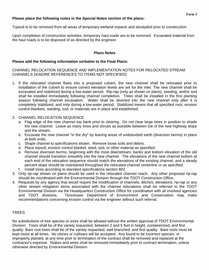
Form J Please place the following notes in the Special Notes section of the plans: Topsoil is to be removed from all areas of temporary wetland impacts and stockpiled prior to construction. Upon completion of construction activities, temporary haul roads are to be removed. Excavated material from the haul roads is to be disposed of as directed by the engineer.
Plans Notes Please add the following information verbatim to the Final Plans: CHANNEL RELOCATION SEQUENCE AND IMPLEMENTATION NOTES FOR RELOCATED STREAM CHANNELS (IGNORE REFERENCES TO ITEMS NOT SPECIFIED) 1. If the relocated channel flows into a proposed culvert, the new channel shall be relocated prior to
installation of the culvert to ensure correct elevation levels are set for the inlet. The new channel shall be excavated and stabilized during a low-water period. Rip-rap (only as shown on plans), seeding, and/or sod shall be installed immediately following channel completion. Trees shall be installed in the first planting season following channel excavation. Water shall be diverted into the new channel only after it is completely stabilized, and only during a low-water period. Stabilized means that all specified rock, erosion control blankets, seeding, sod, or materials are in place and established.
2. CHANNEL RELOCATION SEQUENCE
a. Flag edge of the new channel top bank prior to clearing. Do not clear large trees in position to shade the new channel. Leave as many trees and shrubs as possible between toe of the new highway slope and the stream.
b. Excavate the new channel "in the dry" by leaving areas of undisturbed earth (diversion berms) in place at both ends.
c. Shape channel to specifications shown. Remove loose soils and debris. d. Place topsoil, erosion control blanket. seed, sod, or other material as specified. e. Remove diversion berms, beginning with the most downstream; banks and bottom elevation of the old
channel should transition smoothly into the new channel. The elevations of the new channel bottom at each end of the relocation sequence should match the elevations of the existing channel, and a steady percent slope should be maintained throughout the relocated channel centerline or as specified.
f. Install trees according to standard specifications section 802. 3. Only rip-rap shown on plans should be used in the relocated channel reach. Any other proposed rip-rap
should be coordinated with the Environmental Division through the TDOT Construction Office. 4. Requests by any agency that would require the modification of channels, ditches, elevations, rip-rap or any
other stream mitigation items associated with the channel relocations shall be referred to the TDOT Environmental Division via the Headquarters Construction Office for coordination with all involved agencies and TDOT divisions. Tennessee Department of Environment and Conservation may make recommendations concerning erosion control via the engineer without such referral.
TREES No substitutions of tree species or sizes shall be allowed without the written approval of TDOT Environmental Division. Trees shall be of the variety requested, between 2 and 5 feet in height, containerized, and first quality. Bare root trees shall be of the variety requested, well branched, and first quality. Bare roots must be kept moist at all times. No clones or cultivars will be accepted. Any found to be incorrect species, or improperly planted, at any time prior to termination of the contract shall be removed and replaced at the contractor's expense. Stakes and wires shall be removed immediately prior to contract termination, unless otherwise directed by Environmental Division.

Form J The contractor should arrange several months ahead of time to obtain the correct tree species, as some may require some time to locate. All trees planted shall be wrapped as per section 802.07 of TDOT standard specifications for the road and bridge construction. Trees shall be watered as required through the period of establishment to ensure survival.

STATE OF TENNESSEE DEPARTMENT OF TRANSPORTATION
ENVIRONMENTAL DIVISION SUITE 900 - JAMES K. POLK BUILDING
505 DEADERICK STREET NASHVILLE, TENNESSEE 37243-0334
March 7, 2012
Mary Jennings U.S. Department of Interior Fish and Wildlife Service 446 Neal Street Cookeville, TN 38501 SUBJECT: Fayette County, I-40 Interchange at SR-22 P.E. 24001-1147-44 PIN 114219.00 Dear Ms. Jennings: The Tennessee Department of Transportation proposes to construct the subject project. A Project Location Map is attached. In compliance with the Fish and Wildlife Act of 1958, and the Endangered Species Act of 1973 (as amended), we are requesting a list of threatened or endangered species that may be present in the vicinity of the proposed construction. Please include in your reply the entire project description as listed in the subject line of this request. Your assistance in the preparation of this project is greatly appreciated. If you need additional information, please contact me at 615-532-3880. Sincerely, Matt Richards TDOT Biologist xc: Reading File Project File
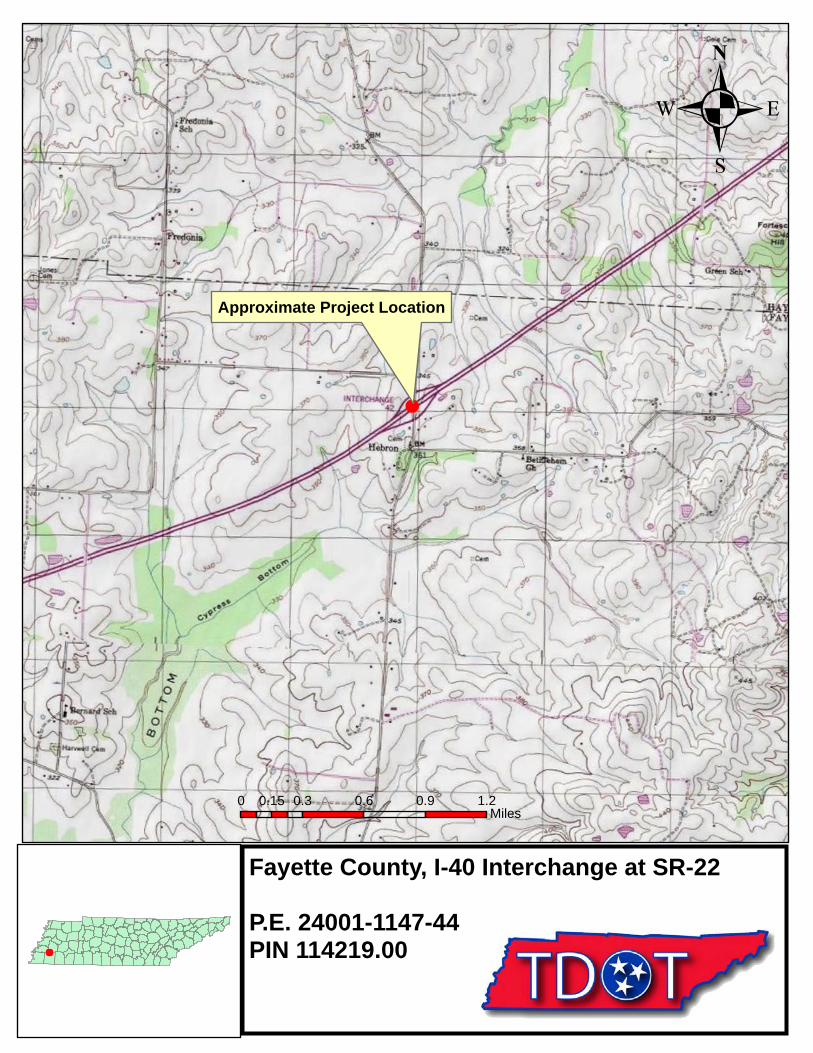
Approximate Project Location
Fayette County, I-40 Interchange at SR-22
P.E. 24001-1147-44PIN 114219.00
.
0 0.3 0.6 0.9 1.20.15Miles
.
United States Department of the Interior FISH AND WILDLIFE SERVICE
3 446 Neal Street Cookeville, TN 38501
March 22, 2012
Mr. Matt Richards Tennessee Department of Transportation Environmental Planning and Permits James K. Polk Building, Suite 900 505 Deaderick Street Nashville, Tennessee 37243-0334
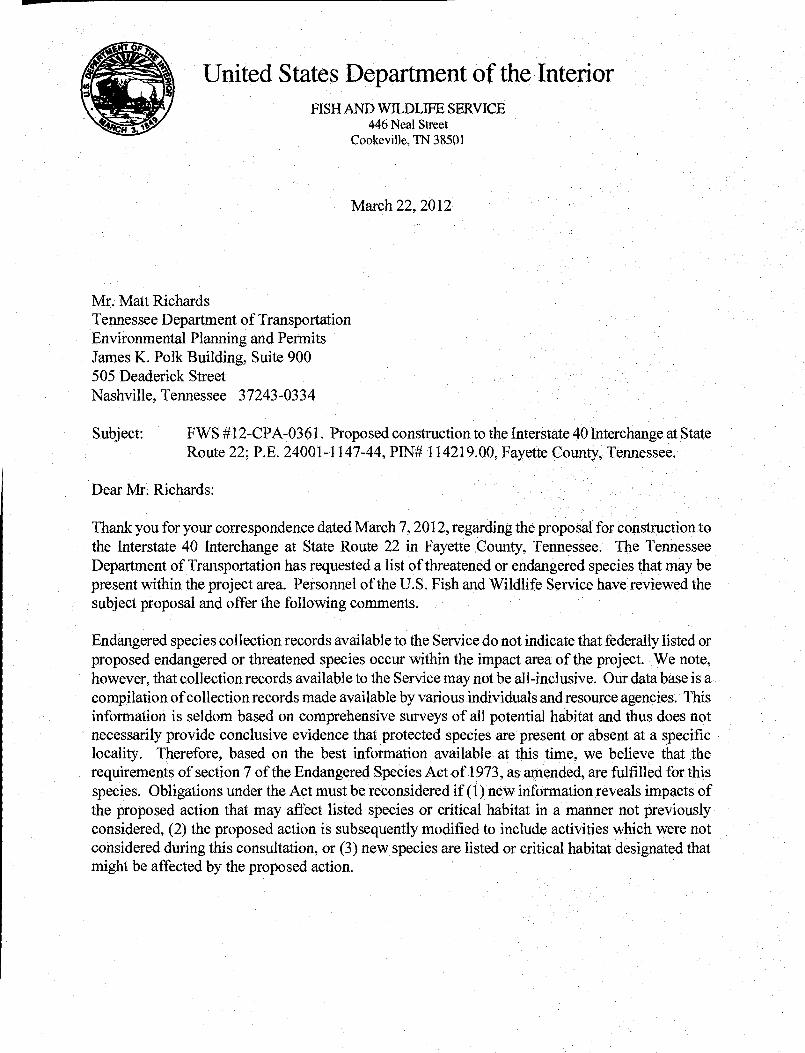
Subject: FWS #1 2-CPA-036 1. Proposed construction to the Interstate 40 Interchange at State Route 22; P.E. 24001-1147-44, PIN# 114219.00, Fayette county, Tennessee.
Dear Mr. Richards:
Thank you for your correspondence dated March 7, 2012, regarding the proposal for construction to the Interstate 40 Interchange at State Route 22 in Fayette County, Tennessee. The Tennessee Department of Transportation has requested a list of threatened or endangered species that may be present within the project area. Personnel of the U.S. Fish and Wildlife Service have reviewed the subject proposal and offer the following comments.
Endangered species collection records available to the Service do not indicate that federally listed or proposed endangered or threatened species occur within the impact area of the project. We note, however, that collection records available to the Service may not be all-inclusive. Our data base is a compilation of collection records made available by various individuals and resource agencies. This information is seldom based on comprehensive surveys of all potential habitat and thus does not necessarily provide conclusive evidence that protected species are present or absent at a specific locality. Therefore, based on the best information available at this time, we believe that the requirements of section 7 of the Endangered Species Act of 1973, as amended, are fulfilled for this species. Obligations under the Act must be reconsidered if (1) new information reveals impacts of the proposed action that may affect listed species or critical habitat in a manner not previously considered, (2) the proposed action is subsequently modified to include activities which were not considered during this consultation, or (3) new species are listed or critical habitat designated that might be affected by the proposed action.

Information available to the Service does not indicate that wetlands exist in the vicinity of the proposed project. However, our wetland determination has been made in the absence of a field inspection and does not constitute a wetland delineation for the purposes of Section 404 of the Clean Water Act. The Corps of Engineers should be contacted if other evidence, particularly that obtained during an on-site inspection, indicates the potential presence of wetlands.
If you have any questions regarding our comments, please contact John Griffith of my staff at 931/528-6481 (ext. 228) or by email atjohngrjfflthçJws.gov .
Sincerely,
Mary E. Jennings Field Supervisor

Species Review Form N Project: Fayette County, I-40 at SR-222 P.E. 24001-0147-44 PIN 114219.00
Page 1 of 2
Date of field study: 3/22/2012 Date TDEC database checked: 3/28/2012 Completed by: Matt Richards, TDOT Species reported within 1 mile radius of project:
Species
Scientific and common names,
followed by (A) for animal or (P) for
plant
Status Species is potentially present in R-O-W because: (A) it is listed by
TDEC within ROW
(B) habitat is present (C) observed during
site visit (D) critical habitat
present within ROW
Species is considered likely NOT present in R-O-W because: (A) Present habitat
unsuitable (B) Not observed
during site visit (C) Original record
questionable (D) Considered
extinct/extirpated
Accommodations to minimize impacts: (A) BMPs are
sufficient to protect species
(B) Special Notes are included on project plans
(C) Individuals will be impacted.
(D) Accommodations not practical due to broad habitat description or mobility of species
Habitat (include blooming, breeding or other information; where found according to TDEC
database; year last observed; reference)
Notes
Fed TN
None
Species reported within 1-mile to 4-mile radius of project:
Species
Scientific and common names,
followed by (A) for animal or (P) for
plant
Status Species is potentially present in R-O-W because: (A) it is listed by
TDEC within ROW
(B) habitat is present (C) observed during
site visit (D) critical habitat
present within ROW
Species is considered likely NOT present in R-O-W because: (A) Present habitat
unsuitable (B) Not observed
during site visit (C) Original record
questionable (D) Considered
extinct/extirpated
Accommodations to minimize impacts: (A) BMPs are
sufficient to protect species
(B) Special Notes are included on project plans
(C) Individuals will be impacted.
(D) Accommodations not practical due to broad habitat description or mobility of species
Habitat (include blooming, breeding or other information; where found according to TDEC
database; year last observed; reference)
Notes
Fed TN
None
Species Review Form N Project: Fayette County, I-40 at SR-222 P.E. 24001-0147-44 PIN 114219.00
Page 2 of 2
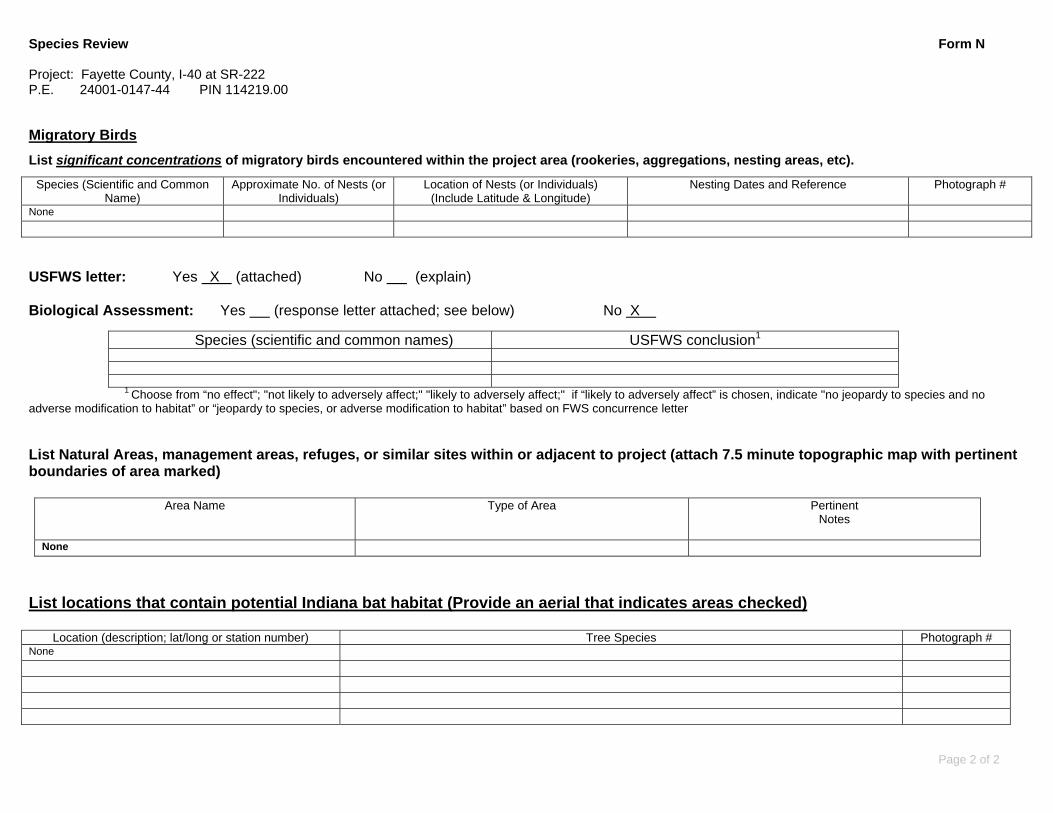
Migratory Birds
List significant concentrations of migratory birds encountered within the project area (rookeries, aggregations, nesting areas, etc).
Species (Scientific and Common Name)
Approximate No. of Nests (or Individuals)
Location of Nests (or Individuals) (Include Latitude & Longitude)
Nesting Dates and Reference Photograph #
None USFWS letter: Yes X (attached) No (explain) Biological Assessment: Yes (response letter attached; see below) No X
Species (scientific and common names) USFWS conclusion1
1 Choose from “no effect"; "not likely to adversely affect;" "likely to adversely affect;" if “likely to adversely affect” is chosen, indicate "no jeopardy to species and no adverse modification to habitat” or “jeopardy to species, or adverse modification to habitat” based on FWS concurrence letter List Natural Areas, management areas, refuges, or similar sites within or adjacent to project (attach 7.5 minute topographic map with pertinent boundaries of area marked)
Area Name Type of Area Pertinent Notes
None
List locations that contain potential Indiana bat habitat (Provide an aerial that indicates areas checked)
Location (description; lat/long or station number) Tree Species Photograph # None

STR‐1 looking downstream from farm road crossing
SPG‐1 looking west

WTL‐2 looking east
WTL‐3 looking west