Embed Size (px)
Citation preview

APPD
Sheet No.
RevDrawing No.
A1C
REVISION DATE
Drawn
Surveyed
Approved
Checked
0
Scale SMEC Australia Pty Ltd ABN 47 065 475 149
- Preliminary drawings
1 2 3 4 5 6
1900s65.dwg
G
F
E
D
C
B
A
Melbourne Survey T 9869 0813 F 9869 0901
Water
Melbourne
Feature And Level Survey
Little River Road
Little River
Melbourne Water Corporation Ref. SVY170022
SVY170022/10 -
10 of 14
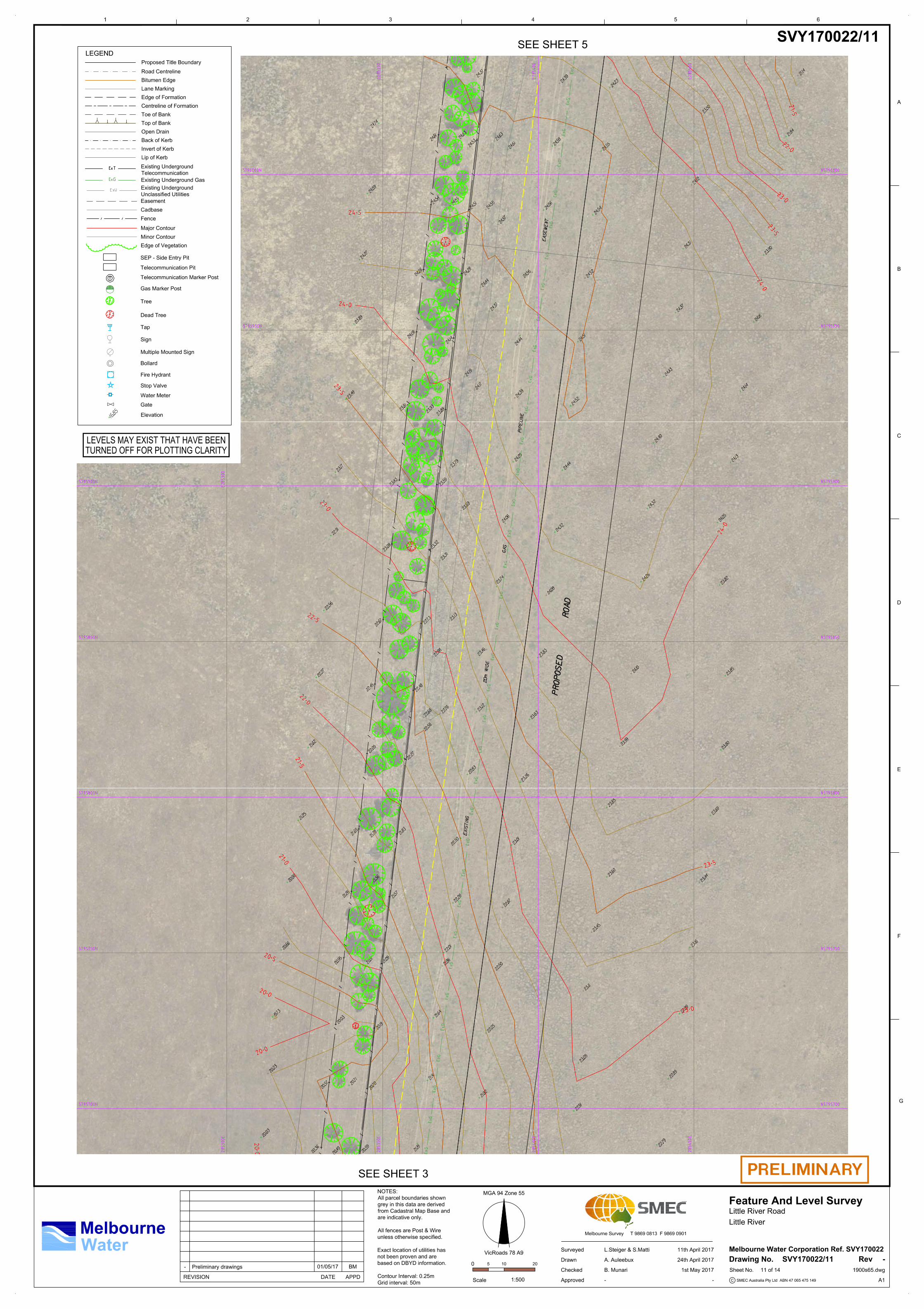
SVY170022/10
L.Steiger & S.Matti 11th April 2017
A. Auleebux 24th April 2017
MGA 94 Zone 55
VicRoads 78 A9
BM01/05/17
B. Munari 1st May 2017
- -
205 10
1:500
SEE SHEET 4
SEE SHEET 2
LEGEND
Road Centreline
Cadbase
Fence
Major Contour
Minor Contour
Tree
Elevation
Bitumen Edge
Lane Marking
Proposed Title Boundary
Easement
Telecommunication Marker Post
Gas Marker Post
Telecommunication Pit
Edge of Formation
Toe of Bank
Top of Bank
Open Drain
Sign
Multiple Mounted Sign
Back of Kerb
Invert of Kerb
Lip of Kerb
SEP - Side Entry Pit
Bollard
Centreline of Formation
Fire Hydrant
Stop Valve
Water Meter
Gate
Dead Tree
Tap
Existing Underground Gas
Existing Underground
Telecommunication
Existing Underground
Unclassified Utilities
Edge of Vegetation
LEVELS MAY EXIST THAT HAVE BEEN
TURNED OFF FOR PLOTTING CLARITY
NOTES:
All parcel boundaries shown
grey in this data are derived
from Cadastral Map Base and
are indicative only.
All fences are Post & Wire
unless otherwise specified.
Exact location of utilities has
not been proven and are
based on DBYD information.
Contour Interval: 0.25m
Grid interval: 50m
APPD
Sheet No.
RevDrawing No.
A1C
REVISION DATE
Drawn
Surveyed
Approved
Checked
0
Scale SMEC Australia Pty Ltd ABN 47 065 475 149
- Preliminary drawings
1 2 3 4 5 6
1900s65.dwg
G
F
E
D
C
B
A
Melbourne Survey T 9869 0813 F 9869 0901
Water
Melbourne
Feature And Level Survey
Little River Road
Little River
Melbourne Water Corporation Ref. SVY170022
SVY170022/11 -
11 of 14
SVY170022/11
L.Steiger & S.Matti 11th April 2017
A. Auleebux 24th April 2017
MGA 94 Zone 55
VicRoads 78 A9
BM01/05/17
B. Munari 1st May 2017
- -
205 10
1:500
SEE SHEET 5
SEE SHEET 3
LEGEND
Road Centreline
Cadbase
Fence
Major Contour
Minor Contour
Tree
Elevation
Bitumen Edge
Lane Marking
Proposed Title Boundary
Easement
Telecommunication Marker Post
Gas Marker Post
Telecommunication Pit
Edge of Formation
Toe of Bank
Top of Bank
Open Drain
Sign
Multiple Mounted Sign
Back of Kerb
Invert of Kerb
Lip of Kerb
SEP - Side Entry Pit
Bollard
Centreline of Formation
Fire Hydrant
Stop Valve
Water Meter
Gate
Dead Tree
Tap
Existing Underground Gas
Existing Underground
Telecommunication
Existing Underground
Unclassified Utilities
Edge of Vegetation
LEVELS MAY EXIST THAT HAVE BEEN
TURNED OFF FOR PLOTTING CLARITY
NOTES:
All parcel boundaries shown
grey in this data are derived
from Cadastral Map Base and
are indicative only.
All fences are Post & Wire
unless otherwise specified.
Exact location of utilities has
not been proven and are
based on DBYD information.
Contour Interval: 0.25m
Grid interval: 50m
APPD
Sheet No.
RevDrawing No.
A1C
REVISION DATE
Drawn
Surveyed
Approved
Checked
0
Scale SMEC Australia Pty Ltd ABN 47 065 475 149
- Preliminary drawings
1 2 3 4 5 6
1900s65.dwg
G
F
E
D
C
B
A
Melbourne Survey T 9869 0813 F 9869 0901
Water
Melbourne
Feature And Level Survey
Little River Road
Little River
Melbourne Water Corporation Ref. SVY170022
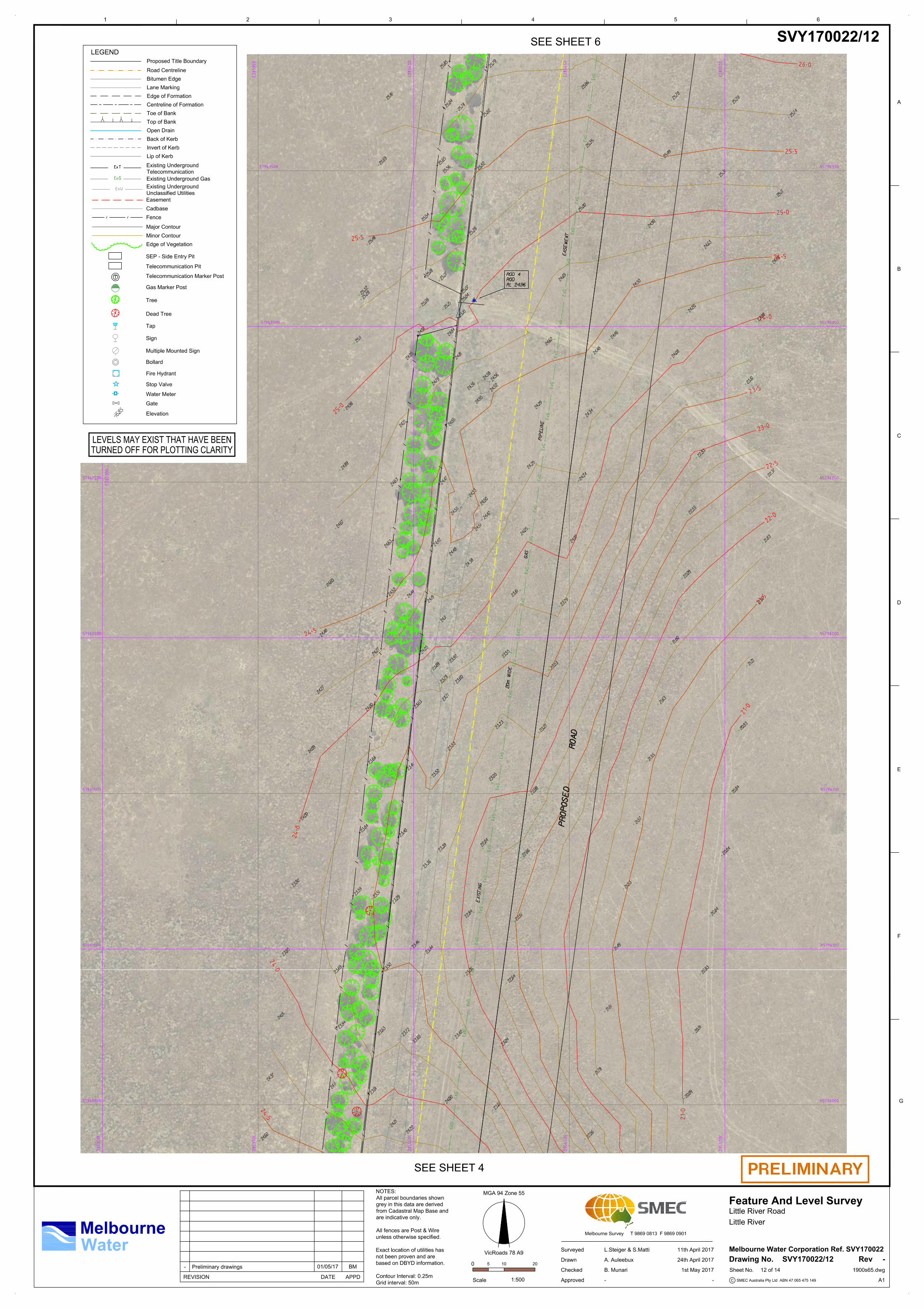
SVY170022/12 -
12 of 14
SVY170022/12
L.Steiger & S.Matti 11th April 2017
A. Auleebux 24th April 2017
MGA 94 Zone 55
VicRoads 78 A9
BM01/05/17
B. Munari 1st May 2017
- -
205 10
1:500
SEE SHEET 6
SEE SHEET 4
LEGEND
Road Centreline
Cadbase
Fence
Major Contour
Minor Contour
Tree
Elevation
Bitumen Edge
Lane Marking
Proposed Title Boundary
Easement
Telecommunication Marker Post
Gas Marker Post
Telecommunication Pit
Edge of Formation
Toe of Bank
Top of Bank
Open Drain
Sign
Multiple Mounted Sign
Back of Kerb
Invert of Kerb
Lip of Kerb
SEP - Side Entry Pit
Bollard
Centreline of Formation
Fire Hydrant
Stop Valve
Water Meter
Gate
Dead Tree
Tap
Existing Underground Gas
Existing Underground
Telecommunication
Existing Underground
Unclassified Utilities
Edge of Vegetation
LEVELS MAY EXIST THAT HAVE BEEN
TURNED OFF FOR PLOTTING CLARITY
NOTES:
All parcel boundaries shown
grey in this data are derived
from Cadastral Map Base and
are indicative only.
All fences are Post & Wire
unless otherwise specified.
Exact location of utilities has
not been proven and are
based on DBYD information.
Contour Interval: 0.25m
Grid interval: 50m

APPD
Sheet No.
RevDrawing No.
A1C
REVISION DATE
Drawn
Surveyed
Approved
Checked
0
Scale SMEC Australia Pty Ltd ABN 47 065 475 149
- Preliminary drawings
1 2 3 4 5 6
1900s65.dwg
G
F
E
D
C
B
A
Melbourne Survey T 9869 0813 F 9869 0901
Water
Melbourne
Feature And Level Survey
Little River Road
Little River
Melbourne Water Corporation Ref. SVY170022
SVY170022/13 -
13 of 14
SVY170022/13
L.Steiger & S.Matti 11th April 2017
A. Auleebux 24th April 2017
MGA 94 Zone 55
VicRoads 78 A9
BM01/05/17
B. Munari 1st May 2017
- -
205 10
1:500
SE
E S
HE
ET
7
SEE SHEET 5
LEGEND
Road Centreline
Cadbase
Fence
Major Contour
Minor Contour
Tree
Elevation
Bitumen Edge
Lane Marking
Proposed Title Boundary
Easement
Telecommunication Marker Post
Gas Marker Post
Telecommunication Pit
Edge of Formation
Toe of Bank
Top of Bank
Open Drain
Sign
Multiple Mounted Sign
Back of Kerb
Invert of Kerb
Lip of Kerb
SEP - Side Entry Pit
Bollard
Centreline of Formation
Fire Hydrant
Stop Valve
Water Meter
Gate
Dead Tree
Tap
Existing Underground Gas
Existing Underground
Telecommunication
Existing Underground
Unclassified Utilities
Edge of Vegetation
LEVELS MAY EXIST THAT HAVE BEEN
TURNED OFF FOR PLOTTING CLARITY
NOTES:
All parcel boundaries shown
grey in this data are derived
from Cadastral Map Base and
are indicative only.
All fences are Post & Wire
unless otherwise specified.
Exact location of utilities has
not been proven and are
based on DBYD information.
Contour Interval: 0.25m
Grid interval: 50m